EP1930741A2 - Verfahren und Vorrichtung zur Erhaltung der Integrität von Langzeitbahnen in einem Fernempfänger - Google Patents
Verfahren und Vorrichtung zur Erhaltung der Integrität von Langzeitbahnen in einem Fernempfänger Download PDFInfo
- Publication number
- EP1930741A2 EP1930741A2 EP20070023669 EP07023669A EP1930741A2 EP 1930741 A2 EP1930741 A2 EP 1930741A2 EP 20070023669 EP20070023669 EP 20070023669 EP 07023669 A EP07023669 A EP 07023669A EP 1930741 A2 EP1930741 A2 EP 1930741A2
- Authority
- EP
- European Patent Office
- Prior art keywords
- receiver
- term
- long
- orbit information
- executable instructions
- Prior art date
- Legal status (The legal status is an assumption and is not a legal conclusion. Google has not performed a legal analysis and makes no representation as to the accuracy of the status listed.)
- Withdrawn
Links
- 238000000034 method Methods 0.000 title claims abstract description 116
- 230000007774 longterm Effects 0.000 title claims description 15
- 230000006870 function Effects 0.000 claims description 28
- 230000001502 supplementing effect Effects 0.000 abstract description 10
- 230000008569 process Effects 0.000 description 89
- 238000005259 measurement Methods 0.000 description 36
- 238000010586 diagram Methods 0.000 description 22
- 238000004891 communication Methods 0.000 description 17
- 239000013589 supplement Substances 0.000 description 12
- 230000007704 transition Effects 0.000 description 12
- 230000004044 response Effects 0.000 description 9
- 230000005540 biological transmission Effects 0.000 description 8
- 238000012545 processing Methods 0.000 description 7
- 230000001934 delay Effects 0.000 description 6
- 102100034112 Alkyldihydroxyacetonephosphate synthase, peroxisomal Human genes 0.000 description 3
- 101000799143 Homo sapiens Alkyldihydroxyacetonephosphate synthase, peroxisomal Proteins 0.000 description 3
- 230000008859 change Effects 0.000 description 3
- 230000036541 health Effects 0.000 description 3
- 238000012544 monitoring process Methods 0.000 description 3
- 230000001960 triggered effect Effects 0.000 description 3
- 230000003416 augmentation Effects 0.000 description 2
- 230000001413 cellular effect Effects 0.000 description 2
- 230000003862 health status Effects 0.000 description 2
- 238000012935 Averaging Methods 0.000 description 1
- 241001125831 Istiophoridae Species 0.000 description 1
- 241000251131 Sphyrna Species 0.000 description 1
- 230000015572 biosynthetic process Effects 0.000 description 1
- 230000008878 coupling Effects 0.000 description 1
- 238000010168 coupling process Methods 0.000 description 1
- 238000005859 coupling reaction Methods 0.000 description 1
- 230000007812 deficiency Effects 0.000 description 1
- 238000005516 engineering process Methods 0.000 description 1
- 230000001360 synchronised effect Effects 0.000 description 1
Images






Classifications
-
- G—PHYSICS
- G01—MEASURING; TESTING
- G01S—RADIO DIRECTION-FINDING; RADIO NAVIGATION; DETERMINING DISTANCE OR VELOCITY BY USE OF RADIO WAVES; LOCATING OR PRESENCE-DETECTING BY USE OF THE REFLECTION OR RERADIATION OF RADIO WAVES; ANALOGOUS ARRANGEMENTS USING OTHER WAVES
- G01S19/00—Satellite radio beacon positioning systems; Determining position, velocity or attitude using signals transmitted by such systems
- G01S19/01—Satellite radio beacon positioning systems transmitting time-stamped messages, e.g. GPS [Global Positioning System], GLONASS [Global Orbiting Navigation Satellite System] or GALILEO
- G01S19/13—Receivers
- G01S19/24—Acquisition or tracking or demodulation of signals transmitted by the system
- G01S19/27—Acquisition or tracking or demodulation of signals transmitted by the system creating, predicting or correcting ephemeris or almanac data within the receiver
-
- G—PHYSICS
- G01—MEASURING; TESTING
- G01S—RADIO DIRECTION-FINDING; RADIO NAVIGATION; DETERMINING DISTANCE OR VELOCITY BY USE OF RADIO WAVES; LOCATING OR PRESENCE-DETECTING BY USE OF THE REFLECTION OR RERADIATION OF RADIO WAVES; ANALOGOUS ARRANGEMENTS USING OTHER WAVES
- G01S19/00—Satellite radio beacon positioning systems; Determining position, velocity or attitude using signals transmitted by such systems
- G01S19/01—Satellite radio beacon positioning systems transmitting time-stamped messages, e.g. GPS [Global Positioning System], GLONASS [Global Orbiting Navigation Satellite System] or GALILEO
- G01S19/03—Cooperating elements; Interaction or communication between different cooperating elements or between cooperating elements and receivers
- G01S19/05—Cooperating elements; Interaction or communication between different cooperating elements or between cooperating elements and receivers providing aiding data
-
- G—PHYSICS
- G01—MEASURING; TESTING
- G01S—RADIO DIRECTION-FINDING; RADIO NAVIGATION; DETERMINING DISTANCE OR VELOCITY BY USE OF RADIO WAVES; LOCATING OR PRESENCE-DETECTING BY USE OF THE REFLECTION OR RERADIATION OF RADIO WAVES; ANALOGOUS ARRANGEMENTS USING OTHER WAVES
- G01S19/00—Satellite radio beacon positioning systems; Determining position, velocity or attitude using signals transmitted by such systems
- G01S19/01—Satellite radio beacon positioning systems transmitting time-stamped messages, e.g. GPS [Global Positioning System], GLONASS [Global Orbiting Navigation Satellite System] or GALILEO
- G01S19/13—Receivers
- G01S19/20—Integrity monitoring, fault detection or fault isolation of space segment
-
- G—PHYSICS
- G01—MEASURING; TESTING
- G01S—RADIO DIRECTION-FINDING; RADIO NAVIGATION; DETERMINING DISTANCE OR VELOCITY BY USE OF RADIO WAVES; LOCATING OR PRESENCE-DETECTING BY USE OF THE REFLECTION OR RERADIATION OF RADIO WAVES; ANALOGOUS ARRANGEMENTS USING OTHER WAVES
- G01S19/00—Satellite radio beacon positioning systems; Determining position, velocity or attitude using signals transmitted by such systems
- G01S19/01—Satellite radio beacon positioning systems transmitting time-stamped messages, e.g. GPS [Global Positioning System], GLONASS [Global Orbiting Navigation Satellite System] or GALILEO
- G01S19/13—Receivers
- G01S19/24—Acquisition or tracking or demodulation of signals transmitted by the system
- G01S19/25—Acquisition or tracking or demodulation of signals transmitted by the system involving aiding data received from a cooperating element, e.g. assisted GPS
- G01S19/258—Acquisition or tracking or demodulation of signals transmitted by the system involving aiding data received from a cooperating element, e.g. assisted GPS relating to the satellite constellation, e.g. almanac, ephemeris data, lists of satellites in view
-
- G—PHYSICS
- G01—MEASURING; TESTING
- G01S—RADIO DIRECTION-FINDING; RADIO NAVIGATION; DETERMINING DISTANCE OR VELOCITY BY USE OF RADIO WAVES; LOCATING OR PRESENCE-DETECTING BY USE OF THE REFLECTION OR RERADIATION OF RADIO WAVES; ANALOGOUS ARRANGEMENTS USING OTHER WAVES
- G01S19/00—Satellite radio beacon positioning systems; Determining position, velocity or attitude using signals transmitted by such systems
- G01S19/01—Satellite radio beacon positioning systems transmitting time-stamped messages, e.g. GPS [Global Positioning System], GLONASS [Global Orbiting Navigation Satellite System] or GALILEO
- G01S19/13—Receivers
- G01S19/24—Acquisition or tracking or demodulation of signals transmitted by the system
- G01S19/25—Acquisition or tracking or demodulation of signals transmitted by the system involving aiding data received from a cooperating element, e.g. assisted GPS
- G01S19/254—Acquisition or tracking or demodulation of signals transmitted by the system involving aiding data received from a cooperating element, e.g. assisted GPS relating to Doppler shift of satellite signals
Definitions
- the present invention generally relates to position-location systems, and more particularly, to monitoring the integrity of satellite-navigation data for a Global-Navigation-Satellite System.
- a Global-Navigation-Satellite-System (GNSS) receiver needs satellite-navigation data, such as satellite orbits and clock models, to compute distances to each of several satellites, which in turn, may be used to compute a position of the GNSS receiver.
- the distances are formed by computing time delays between transmission and reception of satellite signals broadcast from satellites in view of the GNSS receiver and received by the GNSS receiver on or near the surface of the earth. The time delays multiplied by the speed of light yield the distances from the GNSS receiver to each of the satellites that are in view.
- the type of satellite-navigation data acquired by the GNSS receiver is broadcast ephemeris data (or simply broadcast ephemeris) and broadcast satellite time, which are obtained by decoding satellite-navigation messages contained within the satellite signals.
- This broadcast ephemeris includes standard satellite orbits and clock models, and the broadcast satellite time is an absolute time associated with the entire constellation of satellites.
- the GNSS receiver uses the broadcast satellite time to unambiguously determine exact time of broadcast (e.g., by time tagging the transmission and reception) for each of the satellite signals.
- the GNSS receiver uses the broadcast ephemeris to calculate a satellite position for each of the satellites (i.e., where each of the satellites was) when it broadcast its corresponding satellite signals.
- the satellite positions along with the distances to the each of the satellites allow the position of the GNSS receiver to be determined.
- a Global Positioning System (GPS) receiver may receive from each orbiting GPS satellites in view of the GPS receiver a number of GPS signals that are formed using unique pseudo-random noise (PN) codes.
- PN codes are commonly known as C/A codes, and each is used by the GPS receiver to uniquely identify which of the GPS satellites broadcast such the GPS signals.
- the GPS receiver determines the aforementioned time delays by comparing time shifts between or otherwise correlating sequences of (i) the PN codes of the broadcast GPS signals received at the GPS receiver and (ii) replicas of the PN codes locally generated by the GPS receiver.
- the GPS receiver may obtain the PN codes of the broadcast GPS signals to provide unambiguous time delays by processing, and essentially averaging, many frames of the sequences of the PN codes. These time delays are called “sub-millisecond pseudoranges" because they are known modulo of the 1 millisecond boundaries of these frames. By resolving the integer number of milliseconds associated with each of the time delays to each of the satellite, then true, unambiguous pseudoranges may be determined. The process of resolving the unambiguous pseudoranges is commonly known as “integer millisecond ambiguity resolution.”
- a set of four pseudoranges together with knowledge of (i) the absolute times of transmissions of the GPS signals, and (ii) satellite positions at such absolute times is sufficient to solve for the position of the GPS receiver.
- the absolute times of transmission are used for determining the positions of the satellites at the times of transmission, and hence, for determining the position of the GPS receiver.
- each of the GPS satellites move at approximately 3.9 km/s, and thus, the range of such satellite, as observed from the earth, changes at a rate of at most ⁇ 800 m/s.
- Errors in absolute may result in range errors of up to 0.8 m for each millisecond of timing error. These range errors produce a similarly sized error in the GPS receiver position.
- absolute time accuracy of 10 ms is sufficient for position accuracy of approximately 10 m.
- Errors in the absolute timing of much more than 10 ms result in large position errors, and so, current and prior implementations have typically required the absolute time to have a minimum accuracy of approximately 10 milliseconds.
- Downloading the broadcast ephemeris from one or more of the satellites is always slow (i.e., no faster than 18 seconds given that the GPS satellite-navigation message is 900 bits in length and broadcast in a 50 bit-per-second (bps) data stream).
- downloading the broadcast ephemeris is frequently difficult and sometimes impossible.
- some prior and current GPS implementations make use of a terrestrial wireless or wired communication medium for transmitting the broadcast ephemeris to a GPS. These GPS implementations are commonly known as "Assisted-Global-Positioning Systems" or, simply, AGPSs.
- This assistance information may include acquisition-assistance information to assist in acquiring the satellite signals; one or more types of the satellite-navigation data, including, for example, long-term orbit and clock models (collectively LTO information), and any other information that the may be used to acquire the satellite signals and/or determine the position of the GNSS receiver.
- acquisition-assistance information to assist in acquiring the satellite signals
- satellite-navigation data including, for example, long-term orbit and clock models (collectively LTO information)
- LTO information long-term orbit and clock models
- the GNSS receiver uses the assistance data only while it is valid.
- the assistance data (regardless of its type) is valid for a given amount of time or "validity period.”
- the validity period for acquisition-assistance information is generally several minutes.
- the validity period for the broadcast ephemeris is a few (i.e., 2-4) hours.
- the validity period for the LTO information is any amount of time greater than the validity period for the broadcast ephemeris, and may be a few days, a week or more.
- the assistance data When the validity period expires, the assistance data has to be retired and replaced with "fresh" assistance data. Using the assistance data after its validity period expires may prevent acquisition of the satellites and/or cause a significant amount of error in a computed position of the GNSS receiver. Similarly, the satellite-navigation data, such as the ephemeris and the LTO information, may become invalid despite having an unexpired validity period.
- a clock within a given satellite may have drifted outside the expected range or an orbit of a given satellite may have changed beyond an expected range (i) between the time that the assistance data is delivered and used by the GNSS receiver, and/or (ii) during the validity period of the assistance data.
- Using such assistance data may prevent acquisition of the satellites and/or cause a significant amount of error in a computed position of the GNSS receiver.
- the method may include obtaining a predicted pseudorange from a first set of long-term-orbit information possessed by a positioning receiver; obtaining, at the positioning receiver from at least one satellite, a measured pseudorange; determining validity of the predicted pseudorange as a function of the predicted pseudorange and the measured pseudorange; and excluding from the long-term-orbit information at least a portion thereof when the validity of the predicted pseudorange is deemed invalid.
- the method may comprise updating or otherwise supplementing the long-term-orbit information with other orbit information if the validity of the predicted pseudorange is deemed invalid.
- FIG. 1 is a block diagram depicting an example of a position location system
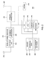
- FIG. 2 is a block diagram depicting an example of a receiver for use with a Global-Navigation-Satellite System
- FIG. 3 is a block diagram depicting an example of a server for use with a Global-Navigation-Satellite System
- FIG. 4 is a flow diagram depicting an example of a process for monitoring the integrity of assistance data in use by one or more receivers of a Global-Navigation-Satellite System;
- FIG. 5 is a flow diagram depicting an example of a process for identifying unhealthy satellites
- FIG. 6 is a flow diagram depicting another example of a process for identifying unhealthy satellites
- FIG. 7 is a flow diagram depicting yet another example of a process for identifying unhealthy satellites
- FIG. 8 is a flow diagram depicting an example of a process for obtaining from a server integrity data and/or fresh aiding data
- FIG. 9 is a flow diagram depicting another example of a process for identifying unhealthy satellites.
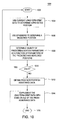
- FIG. 10 is a flow diagram illustrating an example of a process for obtaining and using fresh aiding data.
- FIG. 11 is a flow diagram illustrating another example of a process for obtaining and using fresh aiding data.
- a method comprises :
- the method may comprise excluding at least a portion of the long-term orbit information comprises: discarding long-term orbit information associated with the at least one satellite from which the measured pseudorange is obtained.
- the method may comprise determining validity of the predicted pseudorange comprises: determining a difference between the predicted pseudorange and the measured pseudorange, and wherein excluding at least a portion of the long-term-orbit information occurs when the difference satisfies a given threshold.
- the method may further comprise performing the functions of claim 1 periodically.
- the method may further comprise supplementing the long-term-orbit information with other orbit information when the validity of the predicted pseudorange is deemed invalid.
- the other orbit information comprises information selected from the group consisting of broadcast ephemeris, and long-term-orbit information.
- Advantageously supplementing the long-term-orbit information with orbit information comprises: discarding the long-term-orbit information in lieu of broadcast ephemeris.
- Advantageously determining validity of the predicted pseudorange comprises: determining a difference between the predicted pseudorange and the measured pseudorange, and wherein supplementing the long-term-orbit information with other orbit information occurs when the difference satisfies a given threshold.
- the method may further comprise sending from the first receiver a request for the other orbit information when the validity of the predicted pseudorange is deemed invalid; and receiving at the first receiver, in response to the request, the other orbit information.
- the other orbit information is more current than the long-term-orbit information.
- the other orbit information comprises broadcast ephemeris obtained from the at least one satellite.
- Advantageously supplementing the long-term-orbit information with the other orbit information comprises: replacing all of the long-term-orbit information with other long-term-orbit information.
- the first receiver is a remote receiver, and wherein the second receiver is a reference receiver.
- first and second receivers are the same receiver.
- the same receiver is a remote receiver.
- a method comprises:
- the at least one first location parameter comprises a first parameter and a second parameter, wherein the at least one second location parameter comprises a third parameter and a fourth parameter; wherein the difference comprises a first difference and a second difference; wherein the first difference comprises a difference between the first and third parameters, wherein the second difference comprises a difference between the second and fourth parameters, and wherein confirming that the long-term-orbit information is valid comprises confirming that the first and second differences satisfy respective thresholds.
- the first parameter is a first altitude and the second parameter is any of first longitude and first latitude
- the third parameter is a second altitude and the second parameter is any of a second longitude and second latitude
- the method may further comprise performing (c) and (d) responsive to a deviation between the first and second positions.
- the at least one first location parameter comprises any of a first longitude, first latitude, first altitude and first common-mode error obtained from the long-term-orbit information
- the at least one second location parameter comprises any of a second longitude, second latitude, second altitude and second common-mode error obtained from the satellite-navigation data transmitted from at least one satellite.
- the at least one first location parameter comprises a plurality of first locations parameters
- the at least one second location parameter comprises a plurality of second location parameters, and further comprising: performing (c) and (d) using each of the pluralities of first and second location parameters.
- the method may further comprise excluding from the long-term orbit information at least a portion of thereof when the long-term orbit information is deemed invalid; obtaining other orbit information from a device remotely located from the receiver; and supplementing the long-term-orbit information with the other orbit information when the validity of the predicted pseudorange is deemed invalid.
- the other orbit information comprises information selected from the group consisting of broadcast ephemeris, and long-term-orbit information.
- Advantageously supplementing the long-term-orbit information with the other orbit information comprises: replacing the long-term-orbit information with the other orbit information.
- the method may further comprise sending from the receiver a request for the other orbit information when the difference between satisfies the given threshold; and receiving at the satellite-signal receiver, in response to the request, the other orbit information.
- Advantageously supplementing the long-term-orbit information with the other orbit information comprises: replacing the at least one first location parameter with a third location parameter obtained from the other orbit information when the difference satisfies a given threshold.
- a receiver comprises :
- the executable instructions to exclude at least a portion of the long-term orbit information comprises: executable instructions to discard long-term orbit information associated with the at least one satellite from which the measured pseudorange is obtained.
- the receiver may further comprise executable instructions to supplement the long-term-orbit information with other orbit information when the validity of the predicted pseudorange is deemed invalid.
- the other orbit information comprises information selected from the group consisting of broadcast ephemeris, and long-term-orbit information.
- Advantageously executable instructions to supplement the long-term-orbit information comprise: executable instructions to discard the long-term-orbit information in lieu of broadcast ephemeris.
- the executable instructions to determine validity of the predicted pseudorange comprises executable instructions to determine a difference between the predicted pseudorange and the measured pseudorange, and wherein the processor is operable to execute the executable instructions to exclude at least a portion of the long-term-orbit information when the difference satisfies a given threshold.
- the receiver may further comprise a transceiver for sending from the receiver a request for the other orbit information when the validity of the predicted pseudorange is deemed invalid; and for receiving at the receiver, in response to the request, the other orbit information.
- a system comprises:
- the other orbit information comprises information selected from the group consisting of broadcast ephemeris, and long-term-orbit information.
- executable instructions to supplement the long-term-orbit information with the other orbit information comprise: executable instructions to replace the long-term-orbit information with the other orbit information.
- the first parameter is a first altitude and the second parameter is any of first longitude and first latitude
- the third parameter is a second altitude and the second parameter is any of a second longitude and second latitude
- the first processor is further operable to execute the executable instructions to determine the difference and to confirm that the long-term-orbit information is valid responsive to a deviation between the first and second positions.
- the first processor is further operable to execute the executable instructions to supplement the at least one first location parameter with a third location parameter obtained from the orbit information when the difference satisfies a given threshold.
- a system comprises:
- a system comprises:
- the executable instructions to determine validity of the predicted pseudorange comprise: executable instructions to determine a difference between the predicted pseudorange and the measured pseudorange, and wherein the executable instructions to send to the first receiver the second set of long-term-other orbit information occurs when the difference satisfies a given threshold.
- the first receiver is a remote receiver, and wherein the second receiver is a reference receiver.
- first and second receivers are the same receiver.
- the same receiver is a remote receiver.
- FIG. 1 is a block diagram depicting an example of a Global Navigation Satellite System (“GNSS”) 100.
- the GNSS 100 includes a plurality or constellation of satellites for transmitting satellite signals, as represented satellites 105, a GNSS receiver 104 for receiving the satellite signals, and a server 102.
- GPS Global Positioning System
- GALILEO Global System
- GLONASS Global System
- SBAS Space Based Augmentation System
- QZSS Quadazi-Zenith Satellite System
- LAAS Local Area Augmentation System
- the GNSS receiver 104 may be in communication with the server 102 via a communication link.
- This communication link may be formed, for example, by communicatively coupling one or more nodes of a network, such as a wireless communication system 106 (e.g., cellular telephone network) and/or other type of network 108, including a packet-data network, such as the Internet, a circuit-switched network, such as a PSTN, or a convergence of both.
- a network such as a wireless communication system 106 (e.g., cellular telephone network) and/or other type of network 108, including a packet-data network, such as the Internet, a circuit-switched network, such as a PSTN, or a convergence of both.
- system 100 is shown with only one GNSS receiver 104 and only one server 102. It is to be understood, however, that the system 100 may include and/or be deployed with a plurality of GNSS receivers and servers, and that each of these additional GNSS receivers and servers may communicate with the server 102 (and/or the additional servers) via respective communication links.
- a position of the GNSS receiver 102 may be determined, computed or otherwise formed as a function of the satellite signals received from the satellites 105.
- the GNSS receiver 104 may acquire satellite signals broadcast by a one or more satellites in a constellation (shown collectively as the "satellites 105"), and may measure pseudoranges to one or more (and typically four) of the satellites 105 to locate its unknown position ("receiver position").
- the GNSS receiver 104 may, for example, measure pseudoranges to a plurality of GPS satellites in the GPS constellation.
- the GNSS receiver 104 may receive from the server 102 assistance data, which is formed from, contains, derived from and/or is associated with or otherwise garnered from the satellite signals.
- the GNSS receiver 104 may (i) use the assistance data, including one or more expected or predicted pseudoranges (hereinafter "predicted pseudoranges"), to assist in acquisition of the satellite signals; (ii) measure actual pseudoranges from the satellite signals ("measured pseudoranges"); and (iii) transmit the measured pseudoranges to the server 102 over the communication link, e.g., the wireless communication system 106.
- predicted pseudoranges expected or predicted pseudoranges
- the server 102 may use the measured pseudoranges to solve for the unknown position of the GNSS receiver 104 (i.e., the "receiver position").
- the receiver position may be thereafter transmitted to the GNSS receiver 104 via the communication link, or made available to a third-party requester 199 via another manner, such as through the Internet.
- the GNSS receiver 104 may use the measured pseudoranges to compute its own position (i.e., the receiver position) without transmitting the pseudoranges to the server 102.
- the GNSS receiver 104 uses the assistance data to assist in acquisition of the satellite signals and/or the computation of the receiver position.
- the server 102 uses various broadcasted measurements and information associated with the constellation, including for example, broadcast ephemeris, code phase measurements, carrier phase measurements; Doppler measurements, and the like.
- the broadcasted measurements and information may be obtained directly from the satellite signals and/or by decoding one or more satellite-navigation messages that are broadcast from the satellites 105.
- the server 102 may have to obtain or receive the various broadcasted measurements and information from an external source.
- This external source may be any device that obtains and distributes the broadcasted measurements and information, and may be, for example, embodied as reference network 110; a satellite control station 112, such as a Master Control Station ("MCS") in GPS; or other source of such information, such as a data store communicatively coupled to the Internet.
- MCS Master Control Station
- the reference network 110 may include a plurality of tracking stations; each of which may include a satellite-signal receiver (also known as a reference receiver).
- the plurality of tracking stations collect and distribute, in one form or another, the broadcasted measurements and information from all the satellites in the constellation.
- the reference network 110 may include a one or more tracking stations that collect and distribute, in one form or another, such measurements and information (i) from a subset of all the satellites in the constellation or (ii) for one or more particular regions of the world.
- Each of the aforementioned tracking stations is typically at a known location.
- the assistance information generated by the server 102 may include (i) acquisition-assistance information to assist in acquiring the satellite signals such as code phase measurements, carrier phase measurements; Doppler measurements, and the like; (ii) one or more types of the satellite-navigation data, including, for example, broadcast ephemeris and/or long-term orbit and clock models (collectively LTO information), and (iii) any other information that the may be used to acquire the satellite signals and/or determine the receiver position.
- acquisition-assistance information to assist in acquiring the satellite signals
- the satellite signals such as code phase measurements, carrier phase measurements; Doppler measurements, and the like
- one or more types of the satellite-navigation data including, for example, broadcast ephemeris and/or long-term orbit and clock models (collectively LTO information), and (iii) any other information that the may be used to acquire the satellite signals and/or determine the receiver position.
- the satellite-navigation data may include one or more of the predicted pseudoranges and/or a model of such predicted pseudoranges ("pseudorange model").
- the server 102 may obtain and distribute the predicted pseudoranges and/or the pseudorange model. Details of one or more examples of a system for distributing and using predicted pseudoranges and/or a pseudorange model to acquire satellite signals is described in United States patent 6,453,237, issued September 17, 2002 , which is incorporated by reference herein in its entirety.
- the server 102 and/or the external source may obtain the broadcast ephemeris from the satellites 105 (directly or indirectly), process the broadcast ephemeris (if at all), and distribute the broadcast ephemeris and/or LTO information to the GNSS receiver 104. Details of one or more examples of systems and methods for obtaining, processing, distributing and/or using the broadcast ephemeris and LTO information, such as an LTO model, are described in co-pending U.S. Patent Application Serial Nos. 11/333,787, filed January 17, 2006 ; 09/993,335, filed November 6, 2001 ; and U.S. Patent Nos. 6,560,534 and 6,542,820 , which as noted above, are incorporated herein by reference in their entirety.
- the assistance data (regardless of its type) is valid for its "validity period," which may be a short, medium, or long amount or duration of time.
- the validity period for acquisition-assistance information is generally several minutes.
- the validity period for the broadcast ephemeris is a few (i.e., 2-4) hours.
- the validity period for the LTO information is any amount of time greater than the validity period for the broadcast ephemeris, and may be a few days, a week or more.
- the assistance data may also become invalid unexpectedly during its validity period. This typically occurs when a satellite orbit or satellite clock is adjusted during the validity period of the assistance data.
- the GNSS receiver 104 might not be able to adequately, if at all, acquire the satellite signals and/or compute the receiver position using such current assistance data. If, however, the GNSS receiver 104 is able to acquire the satellite signals and/or compute the receiver position using the invalid assistance data then accuracy of the receiver position is more likely than not to be severely degraded. To detect and potentially compensate for such situation, the server 102 and/or the GNSS receiver 104 may monitor and adjust for deficiencies in the integrity of the assistance data in use by the GNSS receiver 104 ("current assistance data").
- the server 102 may obtain the broadcasted measurements and information, and generate, using such broadcasted measurements and information, integrity data for use with the assistance data.
- the GNSS receiver 104 may obtain from the server 102 (usually responsive to one or more requests from the GNSS receiver 104) more recent or "fresh" assistance data when the GNSS receiver 104 determines that the current assistance data lacks integrity or is no longer valid, as described below with respect to Figures 8 , 10 and 11 , for example.
- the GNSS receiver 104 may do so notwithstanding that the broadcasted measurements and information upon which the current assistance data is deemed valid.
- the broadcasted measurements and information obtained by the server 102 is more up to date than the current assistance data.
- the integrity data produced by the server 102 may reflect this condition, and as such, may be transmitted to the GNSS receiver 104, accordingly.
- FIG. 2 is a block diagram depicting an example of a GNSS receiver 200 for a GNSS.
- the GNSS receiver 200 may be used as the GNSS receiver 104 shown in FIG. 1 .
- the GNSS receiver 200 illustratively comprises a satellite signal receiver 202, a wireless transceiver 204, a processor 206, a memory 208, and optionally, a modem 210 (or other communication port or device).
- the combination of the satellite signal receiver 202, the wireless transceiver 204, and memory 208 may be contained within a mobile station, such as a cellular phone, pager, laptop computer, personal-digital assistant (PDA) and like type wireless device known in the art.
- PDA personal-digital assistant
- the satellite signal receiver 202 comprises circuitry to facilitate receiving and processing satellite signals in a well-known manner.
- the satellite signal receiver 202 comprises a radio frequency (RF) front end 203 coupled to a baseband processor 205.
- the satellite signal receiver 202 acquires the satellite signals via the RF front end 203 and uses the baseband processor 205 to generate pseudorange measurements (i.e., clock errors plus distances between the GNSS receiver 200 and the satellites 105). Any form of a positioning module is useful in this role. Examples of the satellite signal receiver 202 may be found in any of the GL20000, Hammerhead and Marlin available from Global Locate Inc. of San Jose, California, or the SiRFStarlll available from SiRF Technology Holdings Inc. of San Jose, California. An exemplary AGPS receiver that may be used with the invention is described in United States patent 6,453,237 .
- the pseudoranges measurements may be coupled to the wireless transceiver 204 through the processor 206.
- the processor 206 comprises a central processing unit (“CPU") 212, an input/output ("I/O") interface 214, support circuits 218, and at least one bus or serial communication link 216.
- the CPU 210 may be one or more well-known processors or microprocessors.
- the support circuits 216 comprise well known circuits that facilitate operation of the CPU 212.
- the support circuits 216 may comprise at least one of cache, power supplies, clock circuits, and the like.
- the bus or serial communication link 218 provides for transmissions of digital information, including information relating to determining the receiver position, among the CPU 212, support circuits 216, memory 208, I/O interface 214, and other portions of the GNSS receiver 200 (not shown).
- the I/O interface 214 provides an interface to control the transmissions of digital information to and from the GNSS receiver 200.
- the I/O interface 214 may interface with one ore more I/O devices, such as the modem 210, a keyboard, touch screen, and/or other device.
- the transceiver 204 may be used to communicate with the wireless communication system 106 and/or the other type of network 108. Using the transceiver 204, the GNSS receiver 200 may obtain from an external source, such as the server 102, assistance information to assist in acquiring and processing the satellite signals.
- an external source such as the server 102
- the wireless transceiver 204 may transmit, using its antenna 220, the measured pseudoranges for computing the receiver position at a server, such as server 102.
- the measured pseudoranges may be stored within the memory 208 and later used by the GNSS receiver 200 to compute the receiver position.
- the GNSS receiver 200 may perform processing to compute the receiver position using the pseudoranges that are generated by the satellite signal receiver 202. That is, the GNSS receiver 200 may use its processor 206, which is capable of performing functions other than the computation of receiver position, to (i) load from the memory 208 (or obtain directly from the satellite signal receiver 202) the pseudoranges that are generated by the satellite signal receiver 202, and (ii) compute the receiver position using these measured pseudoranges.
- the memory 208 may be embodied as random access memory, read only memory, an erasable programmable read only memory and variations thereof, content addressable memory and variations thereof, flash memory, disk drive storage, removable storage, hard disc storage etc., and any combination thereof.
- the memory 208 may be loaded with and store the current assistance data 222, which can be used to assist in the acquisition of satellite signals or the computation of position or both.
- the current assistance data 222 may be received from the server 102 via the communication link using the wireless transceiver 204 or via the other type computer network 108 (e.g., Internet) using the modem 210 (or other communication port or device that connects the device to a computer network).
- the memory 208 may be loaded with and store executable instructions or other code (e.g., software) for some or all of the process or function described herein.
- executable instructions may include, for example, assistance-data-maintenance software 228 for performing some or all of the processes 800, 1000 and 100 illustrated in Figures 8 , 10 and 11 (below).
- the server 300 may be used as the server 102 shown in FIG. 1 .
- the server 300 illustratively comprises a central processing unit (CPU) 302, input/output (I/O) circuits 304, support circuits 306, a memory 308, and a server clock 310.
- CPU central processing unit
- I/O input/output
- support circuits 306 support circuits
- memory 308 memory
- server clock 310 server clock
- the server 300 may include or be coupled to a device database 312.
- the support circuits 306 comprise well-known circuits that facilitate operation of the CPU 202, such as clock circuits, cache, power supplies, and the like.
- the server clock 310 may be used to provide a time tag to indicate the time-of-arrival of measured pseudoranges transmitted by a GNSS receiver, such as GNSS receiver 104 and/or 200.
- the memory 308 may be embodied as random access memory, read only memory, an erasable programmable read only memory and variations thereof, content addressable memory and variations thereof, flash memory, disk drive storage, removable storage, hard disc storage etc., and any combination thereof.
- the memory 308 may be loaded with and store executable instructions or other code (e.g., software) for any process or function described herein.
- These executable instructions may include, for example, integrity-monitoring software 320 for performing process 400 illustrated in Figure 4 (below), satellite-health-monitoring software 322 for performing any of the processes 500, 600, 700 and 900 illustrated in Figures 5 , 6 , 7 and 9 (below); assistance-data-maintenance software 324 for performing some or all of the process 800 illustrated in Figure 8 (below).
- the server 300 via its I/O circuits 304 may receive the broadcasted measurements and information (e.g., ephemeris, code phase measurements, carrier phase measurements, Doppler measurements, etc.) from the external source (e.g., reference network, satellite control station, Internet).
- the server 300 may use the broadcasted measurements and information to generate or compute the current assistance data and/or one or more previous or future versions of the assistance data.
- the server 300 keeps track of the type of assistance data distributed to each of a plurality of remote receivers (not shown), a time of delivery of the current assistance data, and a time of expiration of the current assistance data.
- this information may be stored in a table 350 within a device database 312.
- the table 350 may have entries (e.g., three are shown) defined by, for example, a remote device ID, the time-of-day that the current assistance data was delivered to each of the remote devices listed in the table, the type of assistance data delivered, and the expiration time of the aiding data.
- an entry 352 indicates that (i) acquisition assistance information was delivered, at time t1, to one of the remote devices having an ID of "1,” and (ii) the acquisition assistance data is set to expire 10 minutes from time t1.
- An entry 354 indicates that (i) broadcast ephemeris was delivered, at time t2, to one of the remote devices having an ID of "2,” and (ii) the broadcast ephemeris data is set to expire four hours from time t2.
- An entry 356 indicates that (i) LTO information was delivered, at time t3, to a device having an ID of "3,” and (ii) the LTO information is set to expire two days from time t3.
- the server 300 monitors the integrity of the current assistance data in use by the remote devices identified in the device database 312, and responsively, produces integrity data 314.
- the integrity data 314 may be stored in the memory 308 and transmitted to one or more remote devices, as described below.
- FIG. 4 is a flow diagram depicting an example of a process 400 for monitoring the integrity of current assistance data used by one or more GNSS receivers of a GNSS.
- the process 400 may be executed by a server of a GNSS, such as the server 300, to monitor the integrity of the current assistance data in use by the GNSS receivers.
- the process 400 begins at step 402 where unhealthy satellites associated with current assistance data used by GNSS receivers are identified. As described by way of example, any of the example processes 500, 600, 700, and 900 (below) may be used to identify unhealthy satellites.
- a period of outage is determined for each of the identified unhealthy satellites.
- a period of outage for each of the identified unhealthy satellites may be obtained from outage notification data generated by a satellite control station, as discussed below with respect to the process 900 of FIG. 9 .
- integrity data is generated. This integrity data includes an identity of each of the unhealthy satellites and a corresponding period of outage, if known. If outage periods are unknown, then the integrity data may include no period of outage or the period of outage may be set to a pre-defined value or to a value based on the particular type of aiding data in use.
- the period of outage may be set to any time between two to four hours when the current assistance data is based on or uses the broadcast ephemeris.
- the period of outage may be set to a time greater than such validity period when the current assistance data is based on or uses the LTO information.
- the integrity data may then be transmitted to the GNSS receivers that are using the current assistance data.
- the integrity data may be transmitted to affected GNSS receivers in response to identified unhealthy satellites. That is, if any satellites were identified as being unhealthy, the integrity data is transmitted to the GNSS receivers having current assistance data that is affected by such unhealthy satellites. Thus, the integrity data is only sent when unhealthy satellites are identified and only sent to the GNSS receivers affected by such identified unhealthy satellites.
- the integrity data may be transmitted to some or all of the GNSS receivers in response to unhealthy satellites being identified.
- the integrity data is transmitted to GNSS receivers in accordance with a pre-defined transmission schedule.
- the integrity data may be periodically broadcast to some or all of the GNSS receivers using the current assistance data; whether or not unhealthy satellites have been identified.
- the integrity data may be transmitted to one or more of the GNSS receivers in response to requests from such GNSS receivers.
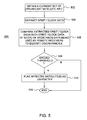
- FIG. 5 is a flow diagram depicting an example of a process 500 for identifying unhealthy satellites.
- the process 500 begins at step 502, where a current set of the broadcasted measurements and information is obtained. This current set of measurements and information may be received over the communication link from a reference network, a satellite control station and/or other source of information.
- satellite orbit data, satellite clock data or both (hereinafter generally referred to as "orbit/clock data") is extracted from the current set of the measurements and information.
- the orbit/clock data is compared with orbit/clock data of one or more sets of the current assistance data being used by GNSS receivers so as to identify discrepancies.
- Such discrepancies may arise, for example, from a change in one or more of the satellites' orbits or a drift in one or more of the satellites' clocks since the time the current assistance data was generated.
- These discrepancies manifest may themselves as differences between the orbit/clock data extracted from the current set of the measurements and information and orbit/clock data underlying or otherwise part of the current assistance data.
- FIG. 6 is a flow diagram depicting another example of a process 600 for identifying unhealthy satellites.
- the process 600 begins at step 602, where a current set of the broadcasted measurements and information is obtained. This current set of measurements and information may be received over the communication link from a reference network, a satellite control station, and/or other source of information.
- satellite health data is extracted from the current set of measurements and information.
- the broadcast ephemeris from each of the satellites contains precise satellite orbit and time model information for such satellite.
- the broadcast ephemeris may contain an indication of satellite health ("health status").
- the MCS In GPS, for example, changes in ephemeris are announced by the MCS by changing the health status in the broadcast ephemeris.
- the satellite health data is analyzed to identify the presence of unhealthy satellites.
- FIG. 7 is a flow diagram depicting yet another example of a process 700 for identifying unhealthy satellites.
- the process 700 begins at step 702, where satellite signals are received at one or more tracking stations having known positions.
- positions of each of the tracking stations are computed using one or more sets of current assistance data being used by the GNSS receivers.
- these positions are compared to the known positions of the tracking stations. If, for example, a given set of the current assistance data that is used to compute one or more of the computed positions of the tracking stations is invalid due to an unhealthy satellite, then these computed positions will be in error (and/or be identified as having discrepancies).
- step 708 a determination is made as to whether any or each of the computed positions exceeds the respective known positions by a pre-defined threshold. If so, the process 700 proceeds to step 710. Otherwise, the process 700 ends at step 712. At step 710, the affected satellites associated with the identified discrepancies are flagged as being unhealthy.
- FIG. 8 is a flow diagram depicting an example of a process 800 for obtaining (e.g., requesting and receiving) from a server integrity data and/or fresh assistance data.
- the process 800 begins at step 802, where measured pseudoranges are measured from between a GNSS receiver, such as the GNSS receiver 104 or 200, and one or more (and typically four) of a plurality of satellites, respectively.
- a GNSS receiver such as the GNSS receiver 104 or 200
- a computed position of the GNSS receiver is computed using the measured pseudoranges and the current assistance data.
- a validity of the computed position is estimated.
- the validity of the computed position may be estimated in any number of various ways. For example, the validity of the computed position may be estimated using a-posteriori residuals, which may be formed as a function of the measured pseudoranges. After formation, these a-posteriori residuals may be analyzed to identify, which, if any, of the measured pseudoranges are erroneous. If any of the measured pseudoranges are identified to be erroneous, then the validity of the computed position may be estimated as being invalid.
- a-posteriori residuals which may be formed as a function of the measured pseudoranges. After formation, these a-posteriori residuals may be analyzed to identify, which, if any, of the measured pseudoranges are erroneous. If any of the measured pseudoranges are identified to be erroneous, then the validity of the computed position may be estimated as being invalid.
- the validity of the computed position may be estimated as a function of the computed position with an a-priori position.
- the a-priori position may be obtained, formed or otherwise garnered from the current assistance data (including any broadcast ephemeris and/or LTO information).
- the validity may be estimated as invalid.
- the validity may be estimated as valid if the difference does not satisfy the particular threshold.
- the particular threshold may be statically set to accommodate for or, alternatively, dynamically set to adjust for one or more of myriad of conditions, including, for example, an actual location of the GNSS receiver, a time since last obtaining the current assistance data, basis and/or type of the current assistance data (e.g., whether the current assistance data includes broadcast ephemeris and/or LTO information), etc.
- the particular threshold may include one or more thresholds, and may be applied as one or more boundaries to the difference. The boundaries may function as one or more upper bounds, one or more lower bounds or some combination thereof.
- the validity of the computed position may be estimated as a function of one or more a-priori pseudorange residuals. That is, the computed position may be estimated as a function of a comparison between respective predicted and measured pseudoranges.
- the predicted pseudorange may be based on the a-priori position and time, and/or other satellite-tracking data.
- the a-priori position and time, and/or any other satellite-tracking data may be garnered from or be part of the current assistance data, including the LTO information, or alternatively, from the broadcast ephemeris garnered from the satellite signals.
- the validity when one or more of the a-priori pseudorange residuals satisfy respective thresholds, the validity may be estimated as invalid. Alternatively, when the a-priori pseudorange residuals do not satisfy respective particular thresholds, the validity may be estimated as valid.
- Each of these respective thresholds may be statically set to accommodate for or, alternatively, dynamically set to adjust for one or more of a myriad of conditions, including, for example, an actual location of the GNSS receiver, a time since last obtaining the current assistance data, basis and/or type of the current assistance data (e.g., whether including broadcast ephemeris and/or LTO information), etc.
- Each of the particular thresholds may include one or more thresholds, and may be applied as boundaries to the a-priori pseudorange residuals. These boundaries may function as one or more upper bounds, one or more lower bounds or some combination thereof.
- estimating the validity of the computed position may use variations and/or combinations of the foregoing, including, for example, comparing computed and predicted altitudes, times, etc.
- the excluded assistance data may be, for example, the current assistance data associated with satellite or satellites from which the measured pseudorange is determined.
- the GNSS receiver obtains from the server, usually in response to one or more requests thereto, the integrity data. After receipt, the GNSS receiver may use the integrity data to determine whether the current assistance data possessed thereby is still valid, as shown in step 812. If the current assistance data is not valid, then the GNSS receiver may use the integrity data to update or otherwise supplement the current assistance data (including, for example, replacing or otherwise modifying the excluded assistance data). Alternatively, the GNSS receiver may transition to step 814 to obtain fresh assistance data. If, on the other hand, the current assistance data is valid, then the process 800 transitions to step 802, at which point the process 800 may be repeated.
- the GNSS receiver obtains from the server, usually in response to one or more requests thereto, the fresh assistance data.
- This fresh assistance data may be formed from and include acquisition-assistance information ("fresh-acquisition-assistance information”) and/or satellite-navigation data (“fresh-satellite-navigation data”) that is more recent than the acquisition-assistance information and/or the satellite-navigation data of the current assistance data.
- the fresh-acquisition-assistance information may include information for acquiring the satellites, which may include at least one of code phase measurements, carrier phase measurements; Doppler measurements, and the like that are garnered from one or more satellite navigation messages broadcast from at least one of the satellites in the constellation.
- the fresh-satellite-navigation data may include broadcast ephemeris, one or more of the predicted pseudoranges, a pseudorange model, LTO information etc. that are more recent than such parameters of the current assistance data.
- the GNSS receiver may use some or all of the fresh assistance data to update or otherwise supplement the current assistance data (including, for example, replacing or otherwise modifying the excluded assistance data), as shown in step 816.
- the GNSS receiver may replace one or more of the predicted pseudoranges of the current assistance data with respective predicted pseudoranges of the fresh assistance data.
- the GNSS receiver may replace one or more of the predicted pseudoranges of the current assistance data with respective predicted pseudoranges of the fresh assistance data, which may be also formed from LTO information, such as an LTO model.
- the GNSS receiver may replace all of the current assistance data with some or all of the fresh assistance data. If, like above, the current assistance data is formed from LTO information, then the GNSS receiver may replace all of the current assistance data with some or all the fresh assistance data, which may also be formed from LTO information. The GNSS receiver may replace all of the current assistance data as such notwithstanding that only a portion of, e.g., only one of the predicted pseudoranges, is estimated (step 808) or determined (step 812) invalid.
- process 800 may transition from step 808 to step 818 as an alternative.
- the GNSS receiver may decode and then use broadcast ephemeris obtained directly from the satellite-navigation messages contained within satellite signals received at the GNSS receiver to update or otherwise supplement the current assistance data (including, for example, replacing or otherwise modifying the excluded assistance data).
- the GNSS receiver may appropriately do so when (i) attenuation of the satellite signals allows for successful decoding of the broadcast ephemeris, and/or (ii) the GNSS receiver is unable to obtain the integrity data and/or fresh assistance data from the server. With respect to the latter, the GNSS receiver may not be able to obtain the integrity data and/or fresh assistance data because, for example, it lacks, cannot maintain or looses connectivity with the server.
- the process 800 may transition to step 802, at which point the process 800 may be repeated.
- the process 800 may be repeated periodically, in continuous fashion, or upon being triggered as a result a condition, such as detecting an error in the receiver position or a satellite position.
- the 800 may be repeated for other reasons as well.
- the GNSS receiver may obtain the integrity data and/or the fresh assistance data without making a request for such data.
- the integrity data and/or the fresh assistance data may be obtained from messages broadcasted from the server.
- the process 800 may transition to step 814 from step 812. This may occur when the a current set of the broadcasted measurements and information and the current assistance data are both based on common information, yet between the time of computing the receiver position and obtaining the current assistance data, the actual positions of the satellites changed. While such changes may be reflected in the fresh-acquisition-assistance information and/or fresh-satellite-navigation data at the server, the integrity data sent to or at the GNSS receiver may not yet reflect such change.
- the integrity data may not yet reflect the changes or the time for triggering replacement may not be reached because the current assistance data is formed from LTO information, such as an LTO model.
- the server may not check and/or compute the integrity data for the current assistance data because its validity period has not expired or is not close to expiring. Other possibilities for this are likely as well.
- FIG. 9 is a flow diagram depicting another example of a process 900 for identifying unhealthy satellites in accordance with the invention.
- the process 900 begins at step 902, where outage notification data generated by a satellite control station is received.
- the outage notification data may be received directly from the satellite control station, or via some other source, such as over the Internet.
- the satellite constellation is monitored by stations around the world under control of a Master Control Station (MCS).
- MCS Master Control Station
- the MCS announces satellite outages that are either planned for the future, or unplanned and immediate, by providing Notice Advisories to Navstar Users (NANUs) via the Internet.
- NANUs Notice Advisories to Navstar Users
- the outage notification data is parsed to identify unhealthy satellites.
- a period of outage for each identified unhealthy satellite is determined. For example, a period of outage for an identified unhealthy satellite may be obtained from NANUs.
- FIG. 10 is a flow diagram illustrating an example of a process 1000 for obtaining and using fresh assistance data.
- the process 1000 is described herein with respect to the architecture shown in Figures 1 and 2 .
- the process 1000 begins at termination block 1002, after the GNSS receiver 104 (i) obtains from the server 102 the current assistance data, which includes LTO information, such as an LTO model, and (ii) acquires the satellite signals from one or more (and typically four) of a plurality of satellites.
- LTO information such as an LTO model
- the current assistance data is referred to as "current LTO information" with respect to process 1000.
- the process 1000 transitions to process block 1004.
- the current LTO information is used to determine a predicted position of the GNSS receiver 104 ("predicted-position fix").
- the predicted-position fix may be determined, for example, by the GNSS receiver 104 and/or the server 102.
- the GNSS receiver 104 and/or server 102 may do so, for instance, by applying the current LTO information and measured pseudoranges to a first recursive or other type filter, and detecting the predicted-position fix from an output of the first filter.
- the predicted-position fix may include one or more respective location parameters, including, for example, latitude, longitude, altitude and/or a common-mode error.
- the server 102 may obtain the measured pseudoranges and current LTO information from the GNSS receiver 104. Alternatively, the server 102 may determine the predicted-position fix using the measured pseudoranges obtained from the GNSS receiver 104 and the current LTO information known by the server 102 to be in use by the GNSS receiver 104. After process block 1004, the process 1000 transitions to process block 1006.
- broadcast ephemeris obtained from satellites signals is used to determine a measured position of the GNSS receiver 104 ("measured-position fix").
- the measured-position fix may be determined by the GNSS receiver 104 and/or one or more of the tracking stations of the reference network 110.
- the GNSS receiver 104 and/or the tracking stations may do so, for instance, by applying the broadcast ephemeris obtained from signals of the satellites (garnered directly from the satellites or indirectly from the server 102) and measured pseudoranges to a second recursive or other type filter, and detecting the measured-position fix from an output of the second filter.
- the measured-position fix like the first position fix, may include one or more respective location parameters, including, for example, latitude, longitude, altitude and/or a common-mode error.
- validity of at least one of the predicted location parameters is determined as a function of such predicted location parameter ("first-location parameter") and a respective one of the measured location parameters (“second-location parameter").
- the validity may be determined, for example, by the GNSS receiver 104 and/or the server 102.
- the GNSS receiver 104 and/or server 102 may do so, for instance, by forming a difference between the first and second location parameters, and then determining if the difference satisfies a given threshold. If, for example, the difference satisfies the given threshold, then the validity of the first-location parameter may be deemed valid, otherwise, the validity of the first-location parameter may be deemed invalid.
- the given threshold may be statically set to accommodate for or, alternatively, dynamically set to adjust for one or more of myriad of conditions, including, for example, an actual location of the GNSS receiver 104, a time since last obtaining the current LTO information, basis and/or type of the current LTO information, etc.
- the particular threshold may include one or more thresholds, and may be applied as boundaries to the difference. These boundaries may function as one or more upper bounds, one or more lower bounds or some combination thereof.
- the same functions may be performed for one or more of the remaining predicted location parameters, as desired. Alternatively, the same functions may be performed for each of the remaining predicted location parameters unless one of them is deemed invalid.
- the server 102 may have to obtain the predicted-position fix from the GNSS receiver 104. Using the predicted-position fix, the server 102 can obtain the first-location parameter. Similarly, the server 102 may have to obtain the measured-position fix from the GNSS receiver 104 or the tracking stations, depending of course, on which determined the measured-position fix. Using the measured-position fix, the server 102 can obtain the second-location parameter.
- the GNSS receiver 104 may have to obtain the predicted-position fix from the server 102. Using the predicted-position fix, the GNSS receiver 104 can obtain the first-location parameter. As shown in decision block 1010, if the GNSS receiver 104 and/or the server 102 determine that the predicted location parameters are valid, then the process returns to termination block 1002 to repeat the process 1000 as desired.
- the GNSS receiver 104 may exclude (e.g., mark to prevent use, remove, delete, etc.) at least a portion of the current LTO information from the current LTO information ("excluded LTO information").
- the excluded LTO information may be, for example, the current LTO information associated with satellite or satellites from which the measured pseudoranges are determined.
- the GNSS receiver 104 may obtain fresh assistance data or "fresh LTO information" from the server 102, as shown in process block 1012.
- the GNSS receiver 104 may obtain the fresh LTO information from the server 102 with or without a request from the GNSS receiver 104 for such fresh LTO information.
- the GNSS receiver 104 may update or otherwise supplement, as noted above with respect to Figure 8 , some or all of the current LTO information with the fresh LTO information, as shown in process block 1014. This may include replacing one or more of the predicted location parameters. As above, the GNSS receiver 104 may update or otherwise supplement some or all of the current LTO information with the fresh LTO information notwithstanding that some or all of the current LTO information (and location parameters thereof) is estimated or determined invalid.
- process 1000 transitions to termination block 1016, at which point the process 1000 ends.
- process 1000 may be repeated periodically, in continuous fashion, or upon being triggered as a result of a condition, such as an error in receiver or satellite position.
- FIG. 11 is a flow diagram illustrating an example of a process 1100 for obtaining and using fresh assistance data. For convenience, the process 1100 is described herein with respect to the architecture shown in Figures 1 and 2 .
- the process 1100 begins at termination block 1102, after the GNSS receiver 104 (i) obtains from the server 102 the current assistance data, which includes LTO information, such as an LTO model, and (ii) acquires the satellite signals from one or more (and typically four) of a plurality of satellites.
- LTO information such as an LTO model
- the current assistance data is referred to as "current LTO information" with respect to process 1100.
- the process 1100 transitions to process block 1104.
- broadcast ephemeris obtained from satellites signals is used to determine a measured position of the GNSS receiver 104 ("measured-position fix").
- the measured-position fix may be determined, for example, by the GNSS receiver 104 and/or one or more of the tracking stations of the reference network 110.
- the GNSS receiver 104 and/or the tracking stations may do so, for instance, by applying the broadcast ephemeris (garnered directly from the satellites or indirectly from the server 102) and measured pseudoranges to a second recursive or other type filter, and detecting the measured-position fix from an output of the second filter.
- the measured-position fix may include one or more respective location parameters, including, for example, latitude, longitude, altitude and/or a common-mode error.
- the current LTO information is used to generate, for each of the location parameters, a respective parameter threshold.
- These parameter thresholds may be generated, for example, by the GNSS receiver 104 and/or the server 102. To facilitate generating the parameter thresholds, the GNSS receiver 104 and the server 102 may have to obtain the measured-position fix from the other.
- the parameter thresholds may be statically set to accommodate for or, alternatively, dynamically set to adjust for one or more of myriad of conditions, including, for example, an actual location of the GNSS receiver 104, a time since last obtaining the current LTO information, basis and/or type of the current LTO information, etc.
- Each of the parameter thresholds may include one or more thresholds, and may be applied as boundaries to the location parameters. The boundaries may function as one or more upper bounds, one or more lower bounds or some combination thereof.
- process block 1108 validity of the current assistance data as a function of at least one of the parameter thresholds and a respective one of the measured location parameters is determined.
- the validity of the current assistance data may be determined, for example, by the GNSS receiver 104 and/or the server 102.
- the GNSS receiver 104 and/or the server 102 may do so, for instance, by determining if such measured location parameter satisfies its respective parameter threshold. If the measured location parameter satisfies its respective parameter threshold, then the validity of the measured location parameter may be deemed valid. Otherwise, the validity of the measured location parameter may be deemed invalid.
- the process block 1108 may be performed for one or more of the remaining measured location parameters, as desired. Alternatively, the same functions may be performed for each of the remaining measured location parameters unless one of them is deemed invalid. To facilitate determining the validity of the current LTO information, the GNSS receiver 104 and the server 102 may have to obtain from the other the respective parameter thresholds and measured location parameters, depending of course, on which maintains such parameter thresholds and measured location parameters.
- the process returns to termination block 1102 to repeat the process 1100 as desired. If, on the other hand, any of the predicted location parameters are deemed invalid, then the GNSS receiver 104 may exclude (e.g., mark to prevent use, remove, delete, etc.) at least a portion of the current LTO information from the current LTO information ("excluded LTO information").
- the excluded LTO information may be, for example, the current LTO information associated with satellite or satellites from which the measured pseudoranges are determined.
- the GNSS receiver 104 may obtain from the server 102 fresh assistance data or "fresh LTO information", as shown in process block 1112.
- the GNSS receiver 104 may obtain the fresh LTO information from the server 102 with or without a request from the GNSS receiver 104.
- the GNSS receiver 104 may update or otherwise supplement, as noted above with respect to Figure 8 , some or all of the current LTO information with the fresh LTO information, as shown in process block 1114. This may include replacing one or more of the predicted location parameters. As above, the GNSS receiver 104 may update or otherwise supplement some or all of the current LTO information with the fresh LTO information notwithstanding that some or all of the current LTO information (and location parameters thereof) is determined invalid.
- process 1100 transitions to termination block 1116, at which point the process 1100 ends.
- process 1100 may be repeated periodically, in continuous fashion, or upon being triggered as a result of a condition, such as an error in receiver or satellite position.
- Pseudolites are ground-based transmitters that broadcast a PN code (similar to the GPS signal) that may be modulated on an L-band carrier signal, generally synchronized with GPS time.
- PN code similar to the GPS signal
- L-band carrier signal generally synchronized with GPS time.
- PN code similar to the GPS signal
- GPS signals is intended to include GPS-like signals from pseudolites or equivalents of pseudolites.
- GPS Global Positioning System
Landscapes
- Engineering & Computer Science (AREA)
- Radar, Positioning & Navigation (AREA)
- Remote Sensing (AREA)
- Computer Networks & Wireless Communication (AREA)
- Physics & Mathematics (AREA)
- General Physics & Mathematics (AREA)
- Power Engineering (AREA)
- Computer Security & Cryptography (AREA)
- Position Fixing By Use Of Radio Waves (AREA)
Applications Claiming Priority (1)
| Application Number | Priority Date | Filing Date | Title |
|---|---|---|---|
| US11/567,629 US20070200752A1 (en) | 2001-06-06 | 2006-12-06 | Method and apparatus for maintaining integrity of long-term orbits in a remote receiver |
Publications (2)
| Publication Number | Publication Date |
|---|---|
| EP1930741A2 true EP1930741A2 (de) | 2008-06-11 |
| EP1930741A3 EP1930741A3 (de) | 2008-07-30 |
Family
ID=39167410
Family Applications (1)
| Application Number | Title | Priority Date | Filing Date |
|---|---|---|---|
| EP20070023669 Withdrawn EP1930741A3 (de) | 2006-12-06 | 2007-12-06 | Verfahren und Vorrichtung zur Erhaltung der Integrität von Langzeitbahnen in einem Fernempfänger |
Country Status (2)
| Country | Link |
|---|---|
| US (3) | US20070200752A1 (de) |
| EP (1) | EP1930741A3 (de) |
Cited By (5)
| Publication number | Priority date | Publication date | Assignee | Title |
|---|---|---|---|---|
| CN102346254A (zh) * | 2010-07-26 | 2012-02-08 | 联发科技股份有限公司 | 更新转换信息参数的方法与装置 |
| CN103499349A (zh) * | 2013-09-29 | 2014-01-08 | 桂林电子科技大学 | 基于广播星历参数外推的卫星轨道中长期预报方法和系统 |
| CN105044740A (zh) * | 2008-04-15 | 2015-11-11 | 高通股份有限公司 | 通过混合sps轨道数据进行定位的方法和装置 |
| CN108226962A (zh) * | 2016-12-22 | 2018-06-29 | 法国国家太空研究中心 | Gnss无线接收机中的多径抑制 |
| CN111290006A (zh) * | 2020-03-06 | 2020-06-16 | Oppo(重庆)智能科技有限公司 | 定位方法和装置 |
Families Citing this family (33)
| Publication number | Priority date | Publication date | Assignee | Title |
|---|---|---|---|---|
| US20070200752A1 (en) | 2001-06-06 | 2007-08-30 | Global Locate, Inc. | Method and apparatus for maintaining integrity of long-term orbits in a remote receiver |
| US8212719B2 (en) * | 2001-06-06 | 2012-07-03 | Global Locate, Inc. | Method and apparatus for background decoding of a satellite navigation message to maintain integrity of long term orbit information in a remote receiver |
| US20080129588A1 (en) | 2001-06-06 | 2008-06-05 | David Albert Lundgren | Method and apparatus for determining location information of a mobile device |
| US8358245B2 (en) * | 2001-06-06 | 2013-01-22 | Broadcom Corporation | Method and system for extending the usability period of long term orbit (LTO) |
| US6651000B2 (en) | 2001-07-25 | 2003-11-18 | Global Locate, Inc. | Method and apparatus for generating and distributing satellite tracking information in a compact format |
| TW200726991A (en) * | 2006-01-11 | 2007-07-16 | Mitac Int Corp | Satellite positioning support system and method thereof |
| US7436355B2 (en) | 2006-04-18 | 2008-10-14 | Andrew Corporation | Method and apparatus for geolocation determination |
| US7468694B2 (en) * | 2006-04-21 | 2008-12-23 | Broadcom Corporation | Communication system with assisted GPS and SBAS |
| US7548200B2 (en) | 2006-04-24 | 2009-06-16 | Nemerix Sa | Ephemeris extension method for GNSS applications |
| JP5657192B2 (ja) * | 2006-06-23 | 2015-01-21 | クゥアルコム・インコーポレイテッドQualcomm Incorporated | Gnssアプリケーションのためのエフェメリス拡張方法及び機器 |
| US8493267B2 (en) | 2006-11-10 | 2013-07-23 | Qualcomm Incorporated | Method and apparatus for position determination with extended SPS orbit information |
| US8676501B2 (en) * | 2006-12-22 | 2014-03-18 | The Boeing Company | Satellite navigation using long-term navigation information |
| US8099186B2 (en) * | 2006-12-22 | 2012-01-17 | The Boeing Company | Satellite navigation using long-term navigation information and autonomous orbit control |
| US8497801B2 (en) * | 2007-02-05 | 2013-07-30 | Qualcomm Incorporated | Prediction refresh method for ephemeris extensions |
| US7786929B2 (en) | 2007-11-26 | 2010-08-31 | Mediatek Inc. | Method and device for predicting GNSS satellite trajectory extension data used in mobile apparatus |
| JP5453722B2 (ja) * | 2008-02-26 | 2014-03-26 | セイコーエプソン株式会社 | 測位システム、測位装置、サーバ及び測位方法 |
| CA2718988C (en) * | 2008-04-15 | 2014-01-28 | Qualcomm Incorporated | Method and apparatus for position determination with hybrid sps orbit data |
| JP5359188B2 (ja) * | 2008-10-24 | 2013-12-04 | セイコーエプソン株式会社 | 長期予測軌道データの信頼性判定方法、長期予測軌道データの提供方法及び情報提供装置 |
| GB2483713B (en) * | 2010-09-20 | 2016-04-06 | St Microelectronics Res & Dev | Signal verification |
| US9423505B2 (en) * | 2010-12-15 | 2016-08-23 | Qualcomm Incorporated | Recovery from position and time outliers in positioning |
| US9354324B2 (en) * | 2011-10-20 | 2016-05-31 | Qualcomm Incorporated | Techniques for affecting a wireless signal-based positioning capability of a mobile device based on one or more onboard sensors |
| KR101981082B1 (ko) * | 2012-05-09 | 2019-05-22 | 삼성전자주식회사 | 전자장치의 위치측정을 위한 방법 및 장치 |
| WO2014108212A1 (en) * | 2013-01-14 | 2014-07-17 | Nokia Corporation | Ephemeris extension |
| JP6322893B2 (ja) * | 2013-03-21 | 2018-05-16 | カシオ計算機株式会社 | 測位処理装置、測位処理方法及びプログラム |
| EP3082574B1 (de) | 2013-12-16 | 2023-07-12 | Dexcom, Inc. | Systeme und verfahren zur überwachung und verwaltung der lebensdauer einer batterie in einem von einem benutzer getragenen analytsensorsystem |
| CN104459732A (zh) * | 2014-12-02 | 2015-03-25 | 北京临近空间飞艇技术开发有限公司 | 一种卫星位置获取方法和系统 |
| CN105758427A (zh) * | 2016-02-26 | 2016-07-13 | 南京航空航天大学 | 一种基于动力学模型辅助的卫星完好性监测方法 |
| CN106468774B (zh) * | 2016-09-09 | 2019-04-09 | 北京航空航天大学 | 一种应用于星基增强系统的星历星钟改正参数及空间信号完好性参数方法 |
| WO2018102146A1 (en) | 2016-12-01 | 2018-06-07 | Google Llc | Methods and systems for location determination |
| WO2020180282A1 (en) | 2019-03-01 | 2020-09-10 | Google Llc | Determining velocity using a reflected positioning signal |
| WO2021006866A1 (en) | 2019-07-08 | 2021-01-14 | Google Llc | Enhancing sensitivity to reflected gnss signals |
| EP3805800B1 (de) | 2019-10-10 | 2024-04-24 | HERE Global B.V. | Identifizierung potenziell manipulierter gnss-navigationsdaten zumindest teilweise auf basis von gnss-referenzdaten. |
| CN113536547B (zh) * | 2021-06-25 | 2023-07-14 | 北京控制工程研究所 | 一种可靠的多源轨道外推自主选用方法 |
Citations (1)
| Publication number | Priority date | Publication date | Assignee | Title |
|---|---|---|---|---|
| US5631838A (en) | 1993-08-02 | 1997-05-20 | Aisin Seiki Kabushiki Kaisha | Apparatus for verifying GPS satellite data |
Family Cites Families (123)
| Publication number | Priority date | Publication date | Assignee | Title |
|---|---|---|---|---|
| US4445118A (en) * | 1981-05-22 | 1984-04-24 | The United States Of America As Represented By The Administrator Of The National Aeronautics And Space Administration | Navigation system and method |
| US4894662A (en) * | 1982-03-01 | 1990-01-16 | Western Atlas International, Inc. | Method and system for determining position on a moving platform, such as a ship, using signals from GPS satellites |
| US4895662A (en) * | 1988-05-31 | 1990-01-23 | The Dow Chemical Company | Purification of effluent from wood pulp bleach plant |
| GB8814456D0 (en) | 1988-06-17 | 1988-08-17 | Cleveland Innovative Technolog | Road vehicle locating system |
| US5390125A (en) * | 1990-02-05 | 1995-02-14 | Caterpillar Inc. | Vehicle position determination system and method |
| US5119504A (en) * | 1990-07-19 | 1992-06-02 | Motorola, Inc. | Position aided subscriber unit for a satellite cellular system |
| US5043736B1 (en) * | 1990-07-27 | 1994-09-06 | Cae Link Corp | Cellular position location system |
| US5845227A (en) * | 1991-02-01 | 1998-12-01 | Peterson; Thomas D. | Method and apparatus for providing shortest elapsed time route and tracking information to users |
| US5225842A (en) * | 1991-05-09 | 1993-07-06 | Navsys Corporation | Vehicle tracking system employing global positioning system (gps) satellites |
| JP3133404B2 (ja) * | 1991-08-20 | 2001-02-05 | ジーイー横河メディカルシステム株式会社 | 超音波診断装置 |
| DE69216112T2 (de) * | 1991-11-08 | 1997-06-12 | Calling Communications Corp | Strahlkompensationsverfahren für satellitenkommunikationssystem |
| US5223844B1 (en) * | 1992-04-17 | 2000-01-25 | Auto Trac Inc | Vehicle tracking and security system |
| US5430657A (en) * | 1992-10-20 | 1995-07-04 | Caterpillar Inc. | Method and apparatus for predicting the position of a satellite in a satellite based navigation system |
| US5418537A (en) * | 1992-11-18 | 1995-05-23 | Trimble Navigation, Ltd. | Location of missing vehicles |
| US5726893A (en) * | 1992-12-17 | 1998-03-10 | Stanford Telecommunications, Inc. | Cellular telephone with voice-in-data modem |
| US5365450A (en) * | 1992-12-17 | 1994-11-15 | Stanford Telecommunications, Inc. | Hybrid GPS/data line unit for rapid, precise, and robust position determination |
| USRE37408E1 (en) * | 1993-05-21 | 2001-10-16 | Trimble Navigation Ltd. | Reduction of time to first fix in an SATPS receiver |
| US5917444A (en) * | 1995-05-22 | 1999-06-29 | Trimble Navigation Ltd. | Reduction of time to first fix in an SATPS receiver |
| US5506781A (en) * | 1994-06-03 | 1996-04-09 | Itt Corporation | RF link control of satellite clocks |
| US5504492A (en) * | 1994-08-01 | 1996-04-02 | Honeywell Inc. | Look ahead satellite positioning system position error bound monitoring system |
| US5786789A (en) * | 1994-11-14 | 1998-07-28 | Trimble Navigation Limited | GPS and cellphone unit having add-on modules |
| US5913170A (en) * | 1994-11-16 | 1999-06-15 | Highwaymaster Communications, Inc. | Locating system and method using a mobile communications network |
| US5589833A (en) * | 1995-04-21 | 1996-12-31 | University Corporation For Atmospheric Research | Radar acquisition system |
| CA2177310A1 (en) | 1995-05-30 | 1996-12-01 | Farshad Mohamadi | Gps ready digital cellular telephone |
| US5673256A (en) * | 1995-07-25 | 1997-09-30 | Motorola, Inc. | Apparatus and method for sending data messages at an optimum time |
| US5736960A (en) * | 1995-09-19 | 1998-04-07 | Northrop Grumman Corporation | Atomic clock augmented global positioning system receivers and global positioning system incorporating same |
| US5884214A (en) * | 1996-09-06 | 1999-03-16 | Snaptrack, Inc. | GPS receiver and method for processing GPS signals |
| US5841396A (en) * | 1996-03-08 | 1998-11-24 | Snaptrack, Inc. | GPS receiver utilizing a communication link |
| US5874914A (en) * | 1995-10-09 | 1999-02-23 | Snaptrack, Inc. | GPS receiver utilizing a communication link |
| US6131067A (en) * | 1995-10-09 | 2000-10-10 | Snaptrack, Inc. | Client-server based remote locator device |
| US6272316B1 (en) * | 1995-11-17 | 2001-08-07 | Globalstar L.P. | Mobile satellite user information request system and methods |
| GB2307812A (en) | 1995-12-02 | 1997-06-04 | Plessey Semiconductors Ltd | GPS Receiver |
| US5808581A (en) * | 1995-12-07 | 1998-09-15 | Trimble Navigation Limited | Fault detection and exclusion method for navigation satellite receivers |
| US6133874A (en) * | 1996-03-08 | 2000-10-17 | Snaptrack, Inc. | Method and apparatus for acquiring satellite positioning system signals |
| US5945944A (en) * | 1996-03-08 | 1999-08-31 | Snaptrack, Inc. | Method and apparatus for determining time for GPS receivers |
| US5963167A (en) * | 1996-03-13 | 1999-10-05 | California Institute Of Technology | Analyzing system for global positioning system and general satellite tracking |
| US5828336A (en) * | 1996-03-29 | 1998-10-27 | The United States Of America As Represented By The Administrator Of The National Aeronautics And Space Administration | Robust real-time wide-area differential GPS navigation |
| US5663735A (en) * | 1996-05-20 | 1997-09-02 | Trimble Navigation Limited | GPS receiver using a radio signal for improving time to first fix |
| US5943014A (en) * | 1996-06-06 | 1999-08-24 | Qualcom Incorporated | Using a signal with increased power for determining the position of a mobile subscriber in a CDMA cellular telephone system |
| US5889492A (en) * | 1996-07-31 | 1999-03-30 | Motorola, Inc. | Method and apparatus for an acquisition-aided Geo-locating subscriber unit |
| GB9618067D0 (en) | 1996-08-29 | 1996-10-09 | Philips Electronics Nv | Combination of a GPS receiver and a telecommunications apparatus |
| US5760737A (en) * | 1996-09-11 | 1998-06-02 | Honeywell Inc. | Navigation system with solution separation apparatus for detecting accuracy failures |
| US6411899B2 (en) * | 1996-10-24 | 2002-06-25 | Trimble Navigation Ltd. | Position based personal digital assistant |
| US5938721A (en) * | 1996-10-24 | 1999-08-17 | Trimble Navigation Limited | Position based personal digital assistant |
| US5893044A (en) * | 1997-01-21 | 1999-04-06 | Motorola Inc. | Real time clock apparatus for fast acquisition or GPS signals |
| US6215442B1 (en) * | 1997-02-03 | 2001-04-10 | Snaptrack, Inc. | Method and apparatus for determining time in a satellite positioning system |
| US5812087A (en) * | 1997-02-03 | 1998-09-22 | Snaptrack, Inc. | Method and apparatus for satellite positioning system based time measurement |
| US5983109A (en) * | 1997-02-03 | 1999-11-09 | Northern Telecom Limited | Method and apparatus for using advanced positioning systems in cellular communications networks |
| CA2283904C (en) * | 1997-03-21 | 2007-01-09 | The Board Of Trustees Of The Leland Stanford Junior University | A system using leo satellites for centimeter-level navigation |
| US5877724A (en) * | 1997-03-25 | 1999-03-02 | Trimble Navigation Limited | Combined position locating and cellular telephone system with a single shared microprocessor |
| US6215441B1 (en) | 1997-04-15 | 2001-04-10 | Snaptrack, Inc. | Satellite positioning reference system and method |
| US6411254B1 (en) * | 1997-04-15 | 2002-06-25 | Snaptrack, Inc. | Satellite positioning reference system and method |
| US6118977A (en) * | 1997-09-11 | 2000-09-12 | Lucent Technologies, Inc. | Telecommunications-assisted satellite positioning system |
| US6070078A (en) | 1997-10-15 | 2000-05-30 | Ericsson Inc. | Reduced global positioning system receiver code shift search space for a cellular telephone system |
| US6097974A (en) * | 1997-12-12 | 2000-08-01 | Ericsson Inc. | Combined GPS and wide bandwidth radiotelephone terminals and methods |
| US6084544A (en) * | 1997-12-18 | 2000-07-04 | Ericsson Inc. | Method for determining the location of a GPS receiver using an estimated reference time |
| US6107960A (en) * | 1998-01-20 | 2000-08-22 | Snaptrack, Inc. | Reducing cross-interference in a combined GPS receiver and communication system |
| AU2866899A (en) * | 1998-02-06 | 1999-08-23 | Government Of The United States Of America, As Represented By The Secretary Of The Navy, The | Orbit/covariance estimation and analysis (ocean) determination for satellites |
| US6081229A (en) * | 1998-03-17 | 2000-06-27 | Qualcomm Incorporated | System and method for determining the position of a wireless CDMA transceiver |
| US6067484A (en) * | 1998-03-23 | 2000-05-23 | Airsys Atm, Inc. | Differential GPS landing system |
| US5999124A (en) * | 1998-04-22 | 1999-12-07 | Snaptrack, Inc, | Satellite positioning system augmentation with wireless communication signals |
| US6122506A (en) * | 1998-05-04 | 2000-09-19 | Trimble Navigation Limited | GSM cellular telephone and GPS receiver combination |
| US6178195B1 (en) * | 1998-05-14 | 2001-01-23 | Motorola, Inc. | Method and apparatus for detecting spread spectrum signals using a signal from a secondary source |
| US6377585B1 (en) * | 1998-06-05 | 2002-04-23 | Datum, Inc. | Precision reference generation system and method |
| US6636740B1 (en) * | 1998-06-16 | 2003-10-21 | Ericsson Inc. | Apparatus and methods for position computation based on broadcast initialization data |
| US6016117A (en) * | 1998-06-26 | 2000-01-18 | Trimble Navigation Limited | Method for the efficient determination of GPS satellite orbital position |
| US6313786B1 (en) * | 1998-07-02 | 2001-11-06 | Snaptrack, Inc. | Method and apparatus for measurement processing of satellite positioning system (SPS) signals |
| US6204808B1 (en) * | 1998-08-13 | 2001-03-20 | Ericsson Inc. | Method and system for aiding GPS receivers via a cellular or PCS network |
| US6188351B1 (en) * | 1998-08-13 | 2001-02-13 | Ericsson Inc. | Method for improving signal acquistion in a global positioning system receiver |
| US6067045A (en) * | 1998-09-01 | 2000-05-23 | Hughes Electronics Corporation | Communication network initialization apparatus and method for fast GPS-based positioning |
| US6222483B1 (en) * | 1998-09-29 | 2001-04-24 | Nokia Mobile Phones Limited | GPS location for mobile phones using the internet |
| JP2000155163A (ja) * | 1998-11-20 | 2000-06-06 | Sony Computer Entertainment Inc | 測位システム、測位方法、測位装置 |
| US6138074A (en) * | 1998-12-23 | 2000-10-24 | Lockheed Martin Corporation | Monitoring station location determination for a satellite navigation system |
| US6693882B1 (en) * | 1999-01-26 | 2004-02-17 | International Business Machines Corporation | Frequency correction burst detection |
| US6058338A (en) * | 1999-02-12 | 2000-05-02 | Qualcomm Incorporated | Method and apparatus for efficient GPS assistance in a communication system |
| GB2347035B (en) * | 1999-02-16 | 2003-10-08 | Symmetricom Inc | Positioning system |
| US6121923A (en) * | 1999-02-19 | 2000-09-19 | Motorola, Inc. | Fixed site and satellite data-aided GPS signal acquisition method and system |
| US6453237B1 (en) * | 1999-04-23 | 2002-09-17 | Global Locate, Inc. | Method and apparatus for locating and providing services to mobile devices |
| US6411892B1 (en) * | 2000-07-13 | 2002-06-25 | Global Locate, Inc. | Method and apparatus for locating mobile receivers using a wide area reference network for propagating ephemeris |
| US7053824B2 (en) * | 2001-11-06 | 2006-05-30 | Global Locate, Inc. | Method and apparatus for receiving a global positioning system signal using a cellular acquisition signal |
| WO2000075685A1 (en) | 1999-06-07 | 2000-12-14 | Telia Ab | Method and arrangement for correcting positioning information |
| US6211819B1 (en) * | 1999-08-27 | 2001-04-03 | Motorola, Inc. | Mobile station location determination in a radio communication system |
| KR100733997B1 (ko) * | 1999-10-20 | 2007-06-29 | 소니 가부시끼 가이샤 | 범지구 측위시스템의 신호수신장치 및 휴대무선단말장치 |
| US6313787B1 (en) * | 1999-11-12 | 2001-11-06 | Motorola, Inc. | Method and apparatus for assisted GPS protocol |
| US6429808B1 (en) * | 1999-11-12 | 2002-08-06 | Motorola, Inc. | Method and apparatus for assisted GPS integrity maintenance |
| US6603978B1 (en) | 2000-03-24 | 2003-08-05 | Ericsson Inc. | Accurate GPS time estimate based on information from a wireless communications system |
| US6839547B2 (en) | 2000-03-30 | 2005-01-04 | Cellguide Ltd. | Enhanced GPS receiver utilizing wireless infrastructure |
| US6642884B2 (en) * | 2000-05-08 | 2003-11-04 | Sigtec Navigation Pty Ltd. | Satellite-based positioning system receiver for weak signal operation |
| US7970412B2 (en) * | 2000-05-18 | 2011-06-28 | Sirf Technology, Inc. | Aided location communication system |
| US6427120B1 (en) * | 2000-08-14 | 2002-07-30 | Sirf Technology, Inc. | Information transfer in a multi-mode global positioning system used with wireless networks |
| US6323804B1 (en) * | 2000-06-06 | 2001-11-27 | Motorola, Inc. | Method and apparatus for GPS time determination |
| US6466846B2 (en) | 2000-07-10 | 2002-10-15 | United Parcel Service Of America, Inc. | Method, apparatus, system, and computer software program product for determining position integrity in a system having a global navigation satellite system (GNSS) component |
| US6775802B2 (en) * | 2000-08-08 | 2004-08-10 | Qualcomm Incorporated | Method, apparatus, and system for signal prediction |
| US6437735B1 (en) * | 2000-09-07 | 2002-08-20 | Ericsson Inc. | Position detection system integrated into mobile terminal |
| US6437734B1 (en) | 2000-10-11 | 2002-08-20 | Seiko Epson Corporation | Satellite navigation receiver and method |
| US6420999B1 (en) * | 2000-10-26 | 2002-07-16 | Qualcomm, Inc. | Method and apparatus for determining an error estimate in a hybrid position determination system |
| US6560534B2 (en) * | 2001-06-06 | 2003-05-06 | Global Locate, Inc. | Method and apparatus for distributing satellite tracking information |
| US20070200752A1 (en) * | 2001-06-06 | 2007-08-30 | Global Locate, Inc. | Method and apparatus for maintaining integrity of long-term orbits in a remote receiver |
| US6992617B2 (en) * | 2003-11-13 | 2006-01-31 | Global Locate, Inc. | Method and apparatus for monitoring the integrity of satellite tracking data used by a remote receiver |
| US6417801B1 (en) * | 2000-11-17 | 2002-07-09 | Global Locate, Inc. | Method and apparatus for time-free processing of GPS signals |
| US6542820B2 (en) * | 2001-06-06 | 2003-04-01 | Global Locate, Inc. | Method and apparatus for generating and distributing satellite tracking information |
| US7196660B2 (en) * | 2000-11-17 | 2007-03-27 | Global Locate, Inc | Method and system for determining time in a satellite positioning system |
| US6424890B1 (en) * | 2000-11-30 | 2002-07-23 | Nokia Mobile Phones, Ltd. | Method and apparatus for satellite orbit interpolation using piecewise hermite interpolating polynomials |
| US6799116B2 (en) * | 2000-12-15 | 2004-09-28 | Trimble Navigation Limited | GPS correction methods, apparatus and signals |
| US6433735B1 (en) * | 2000-12-26 | 2002-08-13 | Telefonaktiebolaget (Lme) | Mobile terminal and system and method for determining the geographic location of a mobile terminal |
| US6570530B2 (en) * | 2001-03-05 | 2003-05-27 | Qualcomm Incorporated | Method and apparatus providing improved position estimate based on an initial coarse position estimate |
| CA2440750C (en) * | 2001-03-15 | 2011-04-26 | Qualcomm Incorporated | Time acquisition in a wireless position determination system |
| US6782330B1 (en) * | 2001-03-22 | 2004-08-24 | Lockheed Martin Corporation | Satellite signal waveform monitor |
| US6563893B2 (en) * | 2001-05-17 | 2003-05-13 | Ut-Battelle, Llc | Carrier-frequency synchronization system for improved amplitude modulation and television broadcast reception |
| US20080186229A1 (en) * | 2001-06-06 | 2008-08-07 | Van Diggelen Frank | Method and Apparatus for Monitoring Satellite-Constellation Configuration To Maintain Integrity of Long-Term-Orbit Information In A Remote Receiver |
| US6651000B2 (en) | 2001-07-25 | 2003-11-18 | Global Locate, Inc. | Method and apparatus for generating and distributing satellite tracking information in a compact format |
| KR100422502B1 (ko) * | 2001-11-23 | 2004-03-11 | 한국전자통신연구원 | 위성의 정밀 궤도 결정 시스템 및 그 방법 |
| US6856282B2 (en) * | 2002-02-08 | 2005-02-15 | Qualcomm Incorporated | Directly acquiring precision code GPS signals |
| US7623871B2 (en) * | 2002-04-24 | 2009-11-24 | Qualcomm Incorporated | Position determination for a wireless terminal in a hybrid position determination system |
| US20030212821A1 (en) * | 2002-05-13 | 2003-11-13 | Kiyon, Inc. | System and method for routing packets in a wired or wireless network |
| US7349390B2 (en) * | 2002-05-28 | 2008-03-25 | Ntt Docomo, Inc. | Packet transmission method and communication system |
| US7158080B2 (en) * | 2002-10-02 | 2007-01-02 | Global Locate, Inc. | Method and apparatus for using long term satellite tracking data in a remote receiver |
| US6826476B2 (en) * | 2002-11-01 | 2004-11-30 | Honeywell International Inc. | Apparatus for improved integrity of wide area differential satellite navigation systems |
| US20040203915A1 (en) * | 2003-01-22 | 2004-10-14 | Van Diggelen Frank | Method and apparatus for locating a mobile receiver having a position cache |
| US6856905B2 (en) * | 2003-04-29 | 2005-02-15 | Garmin At, Inc. | Systems and methods for fault detection and exclusion in navigational systems |
| US20040263386A1 (en) * | 2003-06-26 | 2004-12-30 | King Thomas M. | Satellite positioning system receivers and methods |
| US7020555B1 (en) * | 2003-12-23 | 2006-03-28 | Trimble Navigation Limited | Subscription GPS information service system |
| JP2006084426A (ja) * | 2004-09-17 | 2006-03-30 | Seiko Epson Corp | 測位システム、情報提供装置、情報提供装置の制御プログラム、端末装置、端末装置の制御プログラム |
-
2006
- 2006-12-06 US US11/567,629 patent/US20070200752A1/en not_active Abandoned
-
2007
- 2007-12-06 EP EP20070023669 patent/EP1930741A3/de not_active Withdrawn
-
2010
- 2010-08-16 US US12/857,295 patent/US20110133985A1/en not_active Abandoned
-
2013
- 2013-06-21 US US13/924,069 patent/US8963773B2/en not_active Expired - Fee Related
Patent Citations (1)
| Publication number | Priority date | Publication date | Assignee | Title |
|---|---|---|---|---|
| US5631838A (en) | 1993-08-02 | 1997-05-20 | Aisin Seiki Kabushiki Kaisha | Apparatus for verifying GPS satellite data |
Cited By (7)
| Publication number | Priority date | Publication date | Assignee | Title |
|---|---|---|---|---|
| CN105044740A (zh) * | 2008-04-15 | 2015-11-11 | 高通股份有限公司 | 通过混合sps轨道数据进行定位的方法和装置 |
| CN102346254A (zh) * | 2010-07-26 | 2012-02-08 | 联发科技股份有限公司 | 更新转换信息参数的方法与装置 |
| CN103499349A (zh) * | 2013-09-29 | 2014-01-08 | 桂林电子科技大学 | 基于广播星历参数外推的卫星轨道中长期预报方法和系统 |
| CN103499349B (zh) * | 2013-09-29 | 2016-06-01 | 桂林电子科技大学 | 基于广播星历参数外推的卫星轨道中长期预报方法和系统 |
| CN108226962A (zh) * | 2016-12-22 | 2018-06-29 | 法国国家太空研究中心 | Gnss无线接收机中的多径抑制 |
| CN108226962B (zh) * | 2016-12-22 | 2021-11-02 | 法国国家太空研究中心 | Gnss无线接收机中的多径抑制 |
| CN111290006A (zh) * | 2020-03-06 | 2020-06-16 | Oppo(重庆)智能科技有限公司 | 定位方法和装置 |
Also Published As
| Publication number | Publication date |
|---|---|
| US8963773B2 (en) | 2015-02-24 |
| US20110133985A1 (en) | 2011-06-09 |
| EP1930741A3 (de) | 2008-07-30 |
| US20130285851A1 (en) | 2013-10-31 |
| US20070200752A1 (en) | 2007-08-30 |
Similar Documents
| Publication | Publication Date | Title |
|---|---|---|
| US8963773B2 (en) | Method and apparatus for maintaining integrity of long-term orbits in a remote receiver | |
| EP2063283B1 (de) | Verfahren und Vorrichtung zur Überwachung der Satellitenkonstellationskonfiguration zur Erhaltung der Integrität einer Langzeitbahninformation in einem Fernempfänger | |
| US8212719B2 (en) | Method and apparatus for background decoding of a satellite navigation message to maintain integrity of long term orbit information in a remote receiver | |
| EP1697756B1 (de) | Verfahren und vorrichtung zum überwachen der integrität von satellitenverfolgungsdaten, die von einem fernempfänger verwendet werden | |
| EP2088448A2 (de) | Verfahren und Vorrichtung zur Verbesserung der Genauigkeit und/oder Integrität der Langzeitbahninformation für ein globales Satelliten-Navigationssystem | |
| EP1851564B1 (de) | Verfahren und vorrichtung für ein verbessertes autonomes gps | |
| HK1142408B (en) | A method, receiver, and system for maintaining integrality of satellite navigation data | |
| EP1835300B1 (de) | Verfahren und Vorrichtung um Langzeit-Satellitenbeobachtungsdaten in einem entfernten Empfänger zu nutzen | |
| HK1134137A (en) | A navigation method, a receiver and a server for global navigation satellite | |
| MXPA06005288A (en) | Method and apparatus for monitoring the integrity of satellite tracking data used bya remote receiver |
Legal Events
| Date | Code | Title | Description |
|---|---|---|---|
| PUAI | Public reference made under article 153(3) epc to a published international application that has entered the european phase |
Free format text: ORIGINAL CODE: 0009012 |
|
| AK | Designated contracting states |
Kind code of ref document: A2 Designated state(s): AT BE BG CH CY CZ DE DK EE ES FI FR GB GR HU IE IS IT LI LT LU LV MC MT NL PL PT RO SE SI SK TR |
|
| AX | Request for extension of the european patent |
Extension state: AL BA HR MK RS |
|
| PUAL | Search report despatched |
Free format text: ORIGINAL CODE: 0009013 |
|
| AK | Designated contracting states |
Kind code of ref document: A3 Designated state(s): AT BE BG CH CY CZ DE DK EE ES FI FR GB GR HU IE IS IT LI LT LU LV MC MT NL PL PT RO SE SI SK TR |
|
| AX | Request for extension of the european patent |
Extension state: AL BA HR MK RS |
|
| 17P | Request for examination filed |
Effective date: 20090130 |
|
| 17Q | First examination report despatched |
Effective date: 20090306 |
|
| AKX | Designation fees paid |
Designated state(s): DE FR GB |
|
| STAA | Information on the status of an ep patent application or granted ep patent |
Free format text: STATUS: THE APPLICATION IS DEEMED TO BE WITHDRAWN |
|
| 18D | Application deemed to be withdrawn |
Effective date: 20140701 |