EP1906339B1 - Verfahren zur Erkennung eines Objekts auf einem Bild und Bilderkennungsvorrichtung - Google Patents
Verfahren zur Erkennung eines Objekts auf einem Bild und Bilderkennungsvorrichtung Download PDFInfo
- Publication number
- EP1906339B1 EP1906339B1 EP06018335.7A EP06018335A EP1906339B1 EP 1906339 B1 EP1906339 B1 EP 1906339B1 EP 06018335 A EP06018335 A EP 06018335A EP 1906339 B1 EP1906339 B1 EP 1906339B1
- Authority
- EP
- European Patent Office
- Prior art keywords
- digital map
- image
- map information
- image data
- information
- Prior art date
- Legal status (The legal status is an assumption and is not a legal conclusion. Google has not performed a legal analysis and makes no representation as to the accuracy of the status listed.)
- Not-in-force
Links
Images


Classifications
-
- G—PHYSICS
- G01—MEASURING; TESTING
- G01C—MEASURING DISTANCES, LEVELS OR BEARINGS; SURVEYING; NAVIGATION; GYROSCOPIC INSTRUMENTS; PHOTOGRAMMETRY OR VIDEOGRAMMETRY
- G01C21/00—Navigation; Navigational instruments not provided for in groups G01C1/00 - G01C19/00
- G01C21/26—Navigation; Navigational instruments not provided for in groups G01C1/00 - G01C19/00 specially adapted for navigation in a road network
- G01C21/28—Navigation; Navigational instruments not provided for in groups G01C1/00 - G01C19/00 specially adapted for navigation in a road network with correlation of data from several navigational instruments
- G01C21/30—Map- or contour-matching
-
- G—PHYSICS
- G06—COMPUTING OR CALCULATING; COUNTING
- G06T—IMAGE DATA PROCESSING OR GENERATION, IN GENERAL
- G06T7/00—Image analysis
- G06T7/70—Determining position or orientation of objects or cameras
- G06T7/73—Determining position or orientation of objects or cameras using feature-based methods
-
- G—PHYSICS
- G06—COMPUTING OR CALCULATING; COUNTING
- G06V—IMAGE OR VIDEO RECOGNITION OR UNDERSTANDING
- G06V10/00—Arrangements for image or video recognition or understanding
- G06V10/40—Extraction of image or video features
- G06V10/44—Local feature extraction by analysis of parts of the pattern, e.g. by detecting edges, contours, loops, corners, strokes or intersections; Connectivity analysis, e.g. of connected components
-
- G—PHYSICS
- G06—COMPUTING OR CALCULATING; COUNTING
- G06V—IMAGE OR VIDEO RECOGNITION OR UNDERSTANDING
- G06V20/00—Scenes; Scene-specific elements
- G06V20/50—Context or environment of the image
- G06V20/56—Context or environment of the image exterior to a vehicle by using sensors mounted on the vehicle
- G06V20/588—Recognition of the road, e.g. of lane markings; Recognition of the vehicle driving pattern in relation to the road
Definitions
- the present invention relates to a method for recognizing an object in an image and a corresponding image recognition device, in particular to a method and device that may be employed for identifying elements related to navigation purposes, such as roads or related structures, in an image.
- Image recognition is widely practiced, including in automotive environments.
- image recognition in automotive systems may be advantageously employed for various purposes including navigation or aiding the driver in controlling a vehicle.
- images of a neighborhood of the vehicle are recorded, frequently by a camera onboard a vehicle, and/or analyzed in order to identify objects, such as roads or road edges, that may be of relevance for navigation purposes or for controlling the vehicle.
- identifying an object includes identifying an object type and an object position, but may also include identifying additional object parameters, such as object size or object orientation.
- specific processes may be invoked based on the type and position of the recognized object. For example, the driver of a vehicle may be alerted of an upcoming junction or intersection once the junction or intersection has been identified in the image.
- EP 1 304 607 A1 describes a lane recognition system. Information on lane marker types is stored in a database and is used for lane marker recognition.
- WO 2006/080547 A1 which serves as basis for the preamble of the independent claims, describes an image recognizing apparatus which uses stored land object information for object recognition and position determination.
- a method for recognizing an object in an image comprises the steps of retrieving image data corresponding to the image, retrieving digital map information which comprises map information on at least a portion of an area represented by the image and which comprises information on the object, and analyzing the image data and the digital map information to recognize the object.
- the image data may be retrieved directly from a camera or a video camera or may be read from a storage unit or a memory unit on which the image data is stored.
- the digital map information may be retrieved from any suitable storage unit or memory unit. Since both the image data and the digital map information are analyzed to recognize the object, it is, in particular, possible to analyze the image data to recognize the object and subsequently verify, based on the digital map information, that the object has been identified correctly, thereby improving recognition accuracy. Further, it is also possible to make a prediction, based on the digital map information, on where in the image an object having a specific shape or size or similar may be found. Thereby, the speed and accuracy of identifying an object in an image is improved.
- the step of evaluating the image data and the digital map information may include a step of evaluating the image data to first preliminarily recognize the object and, subsequently, verifying based on the digital map information that the object has been correctly recognized.
- the information on the object comprised by the digital map information may include information on at least one property of the object
- the step of evaluating the image data and the digital map information may include a step of evaluating the image data to recognize the object, then determining the property of the object recognized in the image data, and subsequently comparing the property of the object recognized in the image data with the digital map information.
- the property of the object may, e.g., be one or several of a position, a shape or an orientation of the object.
- the object identification may be verified. Since, according to these embodiments, the digital map information is employed for verifying an object that has previously preliminarily been recognized in the image data, it is possible for the image data to be evaluated by any standard algorithm known in the art. It is to be understood that the term "evaluating the image data" as used herein includes any standard algorithm used for analyzing image data and may, e.g., include filtering the image data in various ways, for example by calculating the convolution of the image data and a suitable filter.
- An example of prediction of at least one property of the object does not form part of the present invention.
- the step of evaluating the image data and the digital map information may also include employing the digital map information to facilitate evaluating the image data to recognize the object.
- the digital map information may be employed to predict at least one property of the object in the image, and the evaluation of the image data may consequently be focused or concentrated according to the property predicted based on the digital map information.
- the predicted property of the object may be employed to assign probabilities that structures in the image are the object to be recognized.
- the property of the object may, e.g., be one or several of a position, a shape or an orientation of the object in the image. Since a specific property of the object is predicted based on the digital map information, the evaluation of the image data may be sped up, thus increasing the speed and accuracy of recognizing the object in the image.
- the information on the object comprised by the digital map information includes information on the position of the object, such that the evaluation of the image data is restricted to a sub-portion or a specific region of the image data that is selected based on the information on the object position.
- the digital map information may be harnessed to predict the likelihood that specific types of objects, such as roads, lane markers, road junctions or road crossings may be found in specific portions of the image, so that it is sufficient to analyze only those portions of the image in which the respective object is found with high probability.
- the information on the object comprised by the digital map information may also include information on a shape and/or an orientation of the object, and the evaluation of the image data may be restricted to identifying objects having shapes and/or orientations selected based on the information on the shape and/or orientation of the object provided by the digital map information.
- the evaluation of the image data and the digital map information to recognize the object may also include comparing a model of the object with the image data.
- the model of the object may have at least one variable parameter, based on which the shape, position, orientation or any other property of the object in the image may be varied, in which case the evaluation of the image data includes finding an optimum value or a close to optimum value for the at least one variable parameter.
- Typical parameters for a straight section of a road include the width of the road and the offset position of the camera taking the image relative to the center of the road.
- the optimum value for the at least one variable parameter may be found using any suitable algorithm. In particular, if not only a single image is to be analyzed, but rather a quasi-continuous stream of images recorded by a video camera is to be analyzed, it being desirable to track a structure once recognized, Bayes filtering or particle filtering may be employed to determine the optimum value for the at least one variable parameter.
- the digital map information may advantageously be retrieved from a navigation system that naturally includes a digital map, e.g., stored on a CD-ROM, a DVD, an internal hard disk of the navigation system or any other suitable storage unit.
- a digital map e.g., stored on a CD-ROM, a DVD, an internal hard disk of the navigation system or any other suitable storage unit.
- the digital map information stored in a navigation system may include information on the shape and/or orientation of specific objects, e.g., on the orientation of individual road segments, for many other objects included in the digital map, such as traffic signs
- the digital map information only includes a qualifier specifying the type of the object, e.g. stop sign. It is to be understood that, even in the latter case, the digital map information at least implicitly includes information on the shape of the object, since the information on the object type stored in the digital map information may be combined with additional information so as to predict the shape of the object in the image.
- the method may further comprise the step of determining a current vehicle position and a current vehicle orientation, and the retrieving of the digital map information is then based on the current vehicle position and the current vehicle orientation. Since the vehicle position and the vehicle orientation are sufficient to predict a portion of the map in which the field of view of the camera will be contained, at least if the position and orientation of the camera relative to the longitudinal and transversal axes of the vehicle are known, it is thereby possibly to retrieve the portion of the digital map only that is indeed required for recognizing the object in the image.
- the method may further comprise the step of recording the image that is to be analyzed, the image showing a neighborhood of a vehicle. This may conveniently be achieved, e.g., by a camera that is installed onboard a vehicle. Thereby, the method according to the present invention may be harnessed for navigation purposes, since images may be analyzed immediately after recording.
- the method further includes the step of providing a result of the recognizing the object to a navigation system.
- a navigation system provides the results of the image recognition for navigation purposes, such as providing driving instructions to a driver, alerting a driver, or controlling a vehicle based on the result of the evaluation of the image data and the digital map information.
- the provision of driving instructions to the driver of the vehicle may be improved based on the results of the image recognition.
- the results of recognizing the object in the image may be also employed for a wide variety of other applications.
- the object to be recognized in the image may be selected from a wide variety of different objects.
- the object is selected from a group comprising a road intersection, a road turnoff, and a traffic sign.
- an image recognition device for recognizing an object in an image
- the memory means for storing the image data and the digital map information may be a single physical storage device, or may be two or several different storage entities.
- the image data could be stored in a first storage unit
- the digital map information could be stored in a second storage unit.
- one or both of the first and second storage units may be integrated with another system or device provided onboard a vehicle, such as a navigation system.
- a navigation system such as a navigation system
- the digital map information that is retrieved by the processing means may be stored in the storage unit of a navigation system
- the image data may be stored in a separately provided storage unit that is a dedicated unit for the image recognition device.
- the memory means include both the storage unit of the navigation system and the dedicated storage unit of the image recognition device, which latter stores the image data.
- the processing means evaluate both the image data and the digital map information in order to recognize the object. Since the digital map information is taken into consideration for evaluating the image data, the advantages described with reference to the method according to the present invention may be harnessed.
- the image recognition device according to the present invention allows both the accuracy and the speed of image recognition to be enhanced.
- the processing means may be adapted such that it evaluates the image data to preliminarily recognize the object and subsequently verifies, based on the digital map information, that the object has been correctly recognized. I.e., the results of evaluating the image data are cross-checked based on the digital map information. By contrast, if the digital map information is not consistent with the preliminarily identified object, the preliminarily identified object will be discarded.
- the information on the object comprised by the digital map information may include information on at least one property of the object
- the processing means may analyze the image data to preliminarily recognize the object, may then determine the corresponding property of the preliminarily recognized object from the image data, and may subsequently compare the corresponding property of the preliminarily identified object of the image data with the corresponding property stored in the digital map information.
- probabilities may be assigned that preliminarily recognized objects indeed are the object to be recognized, based on the result of the comparison.
- the property of the object may be one or several of a position, a shape or an orientation of the object.
- the processing means may also employ the digital map information to facilitate evaluating the image data to recognize the object.
- the processing means may employ the digital map information to predict a property of the object in the image and may subsequently analyze the image data based on the predicted property of the object. This analysis may include assigning probabilities that structures in the image having a specific property indeed correspond to the object to be recognized, based on the predicted property.
- the property of the object may be, e.g., one or several of a position, a shape, or an orientation of the object.
- the information on the object comprised by the digital map information includes information on the position of the object, and the processing means then analyzes a sub-portion of the image data that is selected based on the information on the position of the object comprised by the digital map information.
- the processing means may first determine from the digital map information in which portions of the image it is likely to retrieve an object having this specific object type, and may subsequently analyze only those sub-portions of the image data in which the likelihood of finding an object having the specific object type exceeds a predetermined threshold. Since the amount of data to be analyzed is thereby reduced, the speed at which the task of identifying the object may be carried out is enhanced.
- the processing means may therefore analyze the image data in view of identifying objects having specific shapes and/or orientations that are selected based on the information on the shape and/or orientation of the object.
- the speed and accuracy of image recognition may be further improved.
- the processing means may compare a model of the object with the image data to recognize the object.
- the data required for characterizing the model may also be stored in the memory means, or yet another storage unit may be provided for this purpose.
- the model of the object may have at least one variable parameter, in which case the processing means finds an optimum or close to optimum value for the at least one variable parameter by comparing the model with the image data.
- a Bayes filter or a particle filter may be employed to determine this optimum value for the at least one variable parameter.
- the device may also comprise position determining means for determining a current vehicle position and orientation determining means for determining a current vehicle orientation, which position and orientation determining means are coupled to the processing means, which latter is adapted to select a portion of the digital map information based on the current vehicle position and orientation.
- position and orientation determining means are coupled to the processing means, which latter is adapted to select a portion of the digital map information based on the current vehicle position and orientation.
- the current vehicle position and orientation are sufficient to identify the portion of a digital map that corresponds to the field of view shown by the image.
- dedicated position and orientation determining means may be provided in the image recognition device, it is anticipated that the image recognition device may also be coupled to position and orientation determining means provided in another system or device onboard the vehicle.
- the processing means of the image recognition device is coupled to the position and orientation determining means of the navigation system, so that no separate orientation and position determining means have to be provided in the image recognition device.
- the image recognition device may form an autonomous unit.
- the image recognition device also comprises a camera unit installed in a vehicle for recording the image in which the object is to be recognized, the camera unit being coupled to the memory means and, possibly, the processing means, for providing the image.
- a camera unit installed in a vehicle for recording the image in which the object is to be recognized, the camera unit being coupled to the memory means and, possibly, the processing means, for providing the image.
- the term "camera” is understood to include not only cameras suitable for taking individual pictures, but also video cameras.
- the image recognition device is adapted to perform the method for recognizing an object in an image according to the various embodiments of the present invention, as described above.
- a navigation system and image recognition device assembly which comprises the image recognition device according to any one aspect or embodiment of the present invention as described above.
- the image recognition device may readily access digital map information that is stored in most navigation systems.
- the image recognition device may also readily access information that is provided by other componentry of the navigation system, such as position determining means that may include, e.g., a GPS receiver or a gyroscopic device.
- position determining means may include, e.g., a GPS receiver or a gyroscopic device.
- several features and functionalities of the navigation system may also benefit from the information provided by the image recognition device, so that by integrating the image recognition device into the navigation system, the functionality of the navigation system may be improved.
- the navigation system may comprise a storage unit for storing a digital map, and the image recognition device may be coupled to the storage unit of the navigation system to retrieve at least a portion of the digital map therefrom.
- the storage unit of the navigation system may form a portion of the memory means of the image recognition device as defined above.
- the navigation system may further comprise an optical or acoustical output unit for outputting driving instructions or warning signals to a driver, and the driving instructions or warning signals may be output in dependence on the object recognized by the image recognition device. For example, when the road on which the vehicle is presently traveling is recognized in the image recorded by a camera onboard a vehicle, it may be possible to identify whether the vehicle approaches the edge of the road, for example because the driver of the vehicle is falling asleep. In this case, a respective warning signal may be output to the driver.
- the navigation system may further comprise a position determining means for determining a current vehicle position, the image recognition device providing information on the recognized object to the position determining means, which position determining means improves the accuracy for position determining based on the information on the recognized object.
- the rationale underlying this construction is that information obtained by the image recognition device may be advantageously fed back into the position determining means, after the determined vehicle position of the position determining means has previously been employed for identifying the relevant map portion and has thus been harnessed for identifying the object in the image. More specifically, it is anticipated that the image recognition device is well suited for determining the distance of the vehicle from an object that is close to the vehicle with high accuracy.
- image data not only image data, but also digital map information is evaluated in order to recognize an object in an image.
- digital map information which is frequently available in convenient form; e.g., in navigation systems onboard vehicles, it is possible to enhance both the speed and the accuracy of image recognition.
- the present invention is not restricted thereto. Rather, the various principles of the present invention as described herein may advantageously be employed in different technical fields as well.
- the present invention may be applied with equal facility to any image recognition method or device in which not only an image, but also a map corresponding to the image is available for analysis.
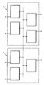
- Fig. 1 is a schematic block diagram showing an image recognition device according to an embodiment of the invention that is coupled to a navigation system.
- Fig. 2 is a schematic view showing a car in which an image recognition device according to the invention is installed.
- Fig. 3 serves to illustrate the principles of a method according to an embodiment of the present invention, in which Fig. 3a shows an exemplary image, Fig. 3b shows a corresponding exemplary digital map, and Fig. 3c serves to illustrate the evaluation of image data based on digital map information.
- Fig. 4 serves to further illustrate the method according to the embodiment of the invention for another exemplary image shown in Fig. 4a and corresponding digital map shown in Fig. 4b .
- Fig. 5 serves to illustrate the method according to the embodiment of the invention for yet another exemplary image shown in Fig. 5a and corresponding digital map shown in Fig. 5b .
- Fig. 6 is a flowchart schematically representing a method which may be used in an embodiment of the present invention.
- Fig. 7 is a flowchart schematically representing a specific implementation of the method of Fig. 6 in more detail.
- Fig. 8 is a flowchart schematically representing a method according to an example.
- Fig. 9 is a flowchart representing a specific implementation of the method of Fig. 8 according to an embodiment of the invention.
- Fig. 10 is a flowchart representing a method for improving position determining accuracy that may be carried out by a navigation system according to an embodiment of the invention.
- Fig. 1 shows a schematic block diagram of an image recognition device 1 according to an embodiment of the invention that is coupled to a navigation system 2.
- the image recognition device 1 includes processing means 3, e.g., any standard processor.
- the processing means 3 are coupled to a camera unit 4 and a memory means 5.
- the camera unit 4 comprises a video camera that provides images at regular time intervals, such as 25 images per second.
- the memory means 5 may be any suitable memory or storage unit that allows for both read and write accesses, such as RAM-type memories of DRAM or SRAM type or a hard disk.
- the memory means 5 preferably has sufficient storage capacity for storing both at least one image provided by the camera unit 4 and a portion of a digital map that corresponds to the region represented by the image.
- Navigation system 2 includes all standard componentry of a navigation system, such as a processing unit or CPU 6, a storage unit 7, e.g., in the form of a CD-ROM, DVD, hard disk or other suitable storage medium, for storing a digital map, an input unit (not shown), such as a keypad, a touchscreen or a microphone, a position and orientation determining means 8 for determining a current vehicle position and orientation that may comprise, e.g., a GPS receiver and a gyroscopic device, and an output unit 9 that may provide optical or acoustical information to a driver and may comprise a display and/or a loudspeaker.
- a navigation system such as a processing unit or CPU 6, a storage unit 7, e.g., in the form of a CD-ROM, DVD, hard disk or other suitable storage medium, for storing a digital map, an input unit (not shown), such as a keypad, a touchscreen or a microphone, a position and orientation determining means 8 for determining a
- a video camera of the camera unit 4 is preferably installed at an elevated position within the car close to an upper position of the windshield, such as close to the rear view mirror or the sun visor.
- All other componentry schematically indicated in Fig. 1 may be installed in an arbitrary position in the car, but is preferably installed close to or in the instrument panel.
- the position and orientation of the video camera of the camera unit 4 is chosen in such a way that, for characteristic road width, a substantial portion of the road on which the vehicle is driving is imaged by the camera.
- Exemplary images taken by camera unit 4 are shown in Figs. 3a , 4a and 5a , respectively, based on which the fundamental operation principles will be explained based on which image recognition device 1 is operated.
- the fundamental principle underlying the operation of image recognition device 1 is that digital map information is employed in order to facilitate the recognition of an object in the image.
- Fig. 3a an exemplary image 20 is shown that is recorded by camera unit 4 when the vehicle is traveling on a straight road segment.
- Road segment 21 is laterally bounded by road edges 24 and is provided with road markings 23 close to the road edges 24 and a central road marking 22.
- Typical tasks in image recognition for image 20 include identifying the road segment 21 itself, or specific structures contained in the image, such as the road edges 24 or the road markings 22, 23. In conventional methods, this task would be solved by analyzing the full image 20 in view of structures having specific geometries, such as straight lines. The task is frequently facilitated by manipulating image 20 in various ways, for example by filtering the image data.
- a grayscale representation of the image may be convoluted with a specific filtering function, such as the second derivative of a Gaussian curve in the horizontal direction. After this filtering, vertical structures such as the road markings 22, 23 and road edges 24 are more clearly visible and may be more readily identified.
- a specific filtering function such as the second derivative of a Gaussian curve in the horizontal direction.
- Fig. 3b a portion 25 of a digital map is schematically shown.
- the portion 25 corresponds to the field of view shown in the image 20 of Fig. 3a , i.e., there is just one straight road segment 26.
- Fig. 3b is only a schematic representation indicating the information that may be available from the digital map, since digital maps are typically stored in a form in which straight road segments are represented by vectors having a given starting point, orientation, and length, as well as additional attributes.
- the width w of the road segment may be explicitly stored in the digital map information. Assuming further that the uncertainty of the current vehicle position determined by the position determining means 8 is small compared to the width w of the road segment 26, the output of the position determining means 8 and the digital map information may be combined to provide an estimate for the offset x 0 of the vehicle relative to the center of the road segment. Based on the quantitative values for the width w of road segment 26 and the offset x 0 , image recognition is greatly facilitated.
- the processing means 3 of the image recognition device 1 is adapted to identify the regions 29 in the image 20 in which specific elements indicating the road edge, such as the road edges 24 and the road markings 23, are expected to be found. If both the offset x 0 and the road width w were precisely known, it would be possible to precisely predict the position of the road edge 24 in image 20 based on simple geometrical optics relations that involve, among other things, the position of the camera unit 4 relative to the vehicle as well as the optical characteristics of the camera unit 4, such as its focal length.
- processing means 3 are adapted to determine the regions 29 in image 20 in which specific objects are likely to be found, recognizing these objects in the image is greatly facilitated.
- two different modes of operation for the image recognition device 1 are conceivable.
- the processing means 3 analyzes the full image data 20 using conventional methods in order to preliminarily identify objects such as road edges 24 and road markings 23.
- identifying an object includes, at least, identifying an object type and identifying an object position in the image. Therefore, if based on the conventional image recognition, road markings and road edges have been preliminarily identified, i.e., their position in the image has been determined, this preliminary identification is verified against the digital map information. For this purpose, the position of the preliminarily identified road edges and road markings are compared with the regions 29 in which such objects are expected to be located based on the digital map information. Objects that are found to lie outside regions 29 are discarded. Therefore, in the first mode of operation, the digital map information is employed to cross-check or verify results of a preliminary image recognition, which latter is based on the image data only.
- the processing means 3 first determines the regions 29 in which the road edges 24 and road markings 23 are expected to be located. In the subsequent image recognition, portions of the image that are located outside regions 29 will be discarded, as is schematically indicated in the modified image 28 of Fig. 3c , in which these discarded regions are indicated with a diagonal line pattern. While standard image recognition algorithms may still be employed to identify the road edges 24 and road markings 23 in regions 29, the restriction to regions 29 greatly reduces the amount of data to be analyzed, thereby enhancing image recognition speed.
- the digital map information may be advantageously employed to predict the position or the regions, in which objects having a specific object type may be found in image 20.
- regions 29 having "hard boundaries" are employed in the above exemplary description, i.e., all structures outside these regions are discarded, more general probability distributions having no sharp cut-off may also be employed in order to quantify the likelihood that a structure in the image having a specific position, shape or orientation indeed is the object to be identified.
- the position of the road edges or road markings is predicted based on the digital map, and the position of a structure identified in the image is compared with this position.
- the structure is assigned a probability in dependence on the comparison, i.e., the closer the position of the structure in the image to the position determined from the digital map, the higher the assigned probability that the structure indeed is the object to be recognized.
- the assigning of probabilities may be employed in both the first mode of operation ( Figs. 6 and 7 ) and the second mode of operation ( Figs. 8 und 9 ).
- digital maps comprise road segment attributes that may advantageously be harnessed for the purposes outlined above.
- road segments typically have an attribute specifying a road segment type, such as highway, or specifying the number of lanes in each direction. While typically not allowing one to establish the precise width of the road segment, these road segment attributes may be evaluated in order to obtain an estimate for width w.
- FIG. 4 another exemplary image 30 provided by the camera unit 4 is shown, in which a road 31 comprises a straight portion 32 and a bend 33.
- the corresponding digital map information is schematically shown in plan view 34 of Fig. 4b , reference numeral 35 denoting the road segment in general, while 36 and 37 denote the straight portion and the bend, respectively.
- the vehicle position 38 has, again, only been schematically indicated. From the vehicle position determined by the position determining means 38 and the digital map information comprising information on the geometrical shape of the road 36, it is possible to determine the distance d of the vehicle from the bend.
- the digital map typically includes fairly accurate information as to the direction of the road along its longitudinal direction
- the uncertainty in d is mainly due to the uncertainty in determining the vehicle position by the position determining means 8. From the distance d and the position of the camera unit relative to the vehicle, it is again possible to establish in which regions of image 30 the road edges of road segment 31 are to be expected. More specifically, it is possible to establish not only the regions in which the road edges of the straight portion 32 of road segment 31 are likely located, but to also establish in which regions of image 30 the road edges of the curved portion 33 are to be expected. Still further, with the curvature of bend 37 being known from digital map information, it is even possible to predict the shape of the road edges of curve section 33.
- the processing means 3 of the image recognition device 1 may employ both modes of operation outlined above for, e.g., recognizing the edges of road segment 31 in image 30.
- the digital map information 34 may be used to verify that a preliminarily identified road edge, that has been determined based only on image data 30, has been correctly recognized with a specific probability.
- the digital map information, schematically indicated at 34 may also be used to identify regions of image data 30 that need to be analyzed, since road edges are likely to be found in these regions, thereby predicting the position and shape of road edges in image 30 and facilitating the task of image recognition.
- model of road edges of a straight section of a road segment will be, in plan view, a pair of essentially parallel lines having a distance corresponding to the width of the road segment.
- the distance of the road edges is an unknown parameter that has to be established by analyzing the image data.
- Other model parameters for modeling the road edges of a straight road segment may include, e.g., the direction of the road segment relative to the direction of view of camera unit 4, and an offset position of the road edges relative to camera unit 4.
- recognizing road edges of a road segment in image data 20, 30 then involves determining the set of parameters such that the model optimally describes the image data. For this purpose, a figure of merit is determined for a specific set of parameters, which figure of merit describes the similarity of the model with the image data, and the set of parameters for which the corresponding model has the maximum figure of merit is established. While this may, in principle, be achieved by sampling over many different sets of parameters, the task is frequently facilitated by employing Bayes filtering or particle filtering. It should be noted that, in such cases, the digital map information frequently may provide natural constraints to the range of parameters that has to be investigated. For example, the width w of the road segment in Fig. 3 or the distance d of the vehicle from the bend in Fig. 4 allow one to restrict the corresponding model parameters substantially to a small neighborhood around the parameters established from digital map information.
- a straight road or straight road segments may be approximated by a pair of essentially parallel lines, in plan view, for a curved road as shown in Fig. 4 more complex models are required.
- a curved road may be approximated by a series of essentially straight road segment portions, the longitudinal axes of which may be tilted relative to one another.
- more complex models for curved roads may be employed, e.g., by approximating portions of the road as clothoid curves.
- the digital map information is employed to facilitate evaluating the image data, it may be suitable to select the type of model employed based on the data format provided by the digital map.
- modeling the road as series of straight road segment portions may be suitable, while, if the digital map also employs a clothoid parameter format, modeling in terms of clothoid curves may be preferable.
- FIG. 5 yet another example of image data 40 is shown, showing a road turnoff, with road 42 turning off from road 41 on which the vehicle is currently traveling.
- the corresponding digital map information 43 is schematically shown in Fig. 5b in plan view, in which the various parameters that may be established from the digital map in combination with the current vehicle position 46 are schematically indicated.
- the roads are designated by 44 and 45.
- Parameters that are relevant for identifying both roads in image data 40 include the width w of road 44, the width w t of road 45, the distance d of the vehicle, schematically indicated at 46, from the turnoff, and the angle ⁇ at which the longitudinal axes of road 44, 45 intersect at the position of the turnoff.
- all parameters schematically indicated in the digital map information 43 may advantageously be employed to facilitate the task of recognizing road edges in image data 40, based on either one of the operation modes of the image recognition device 3 described above, namely cross-checking and prediction.
- the image data i.e., only the image data
- the analysis of image data at step 51 may include all methods that are employed in conventional image recognition devices.
- the analysis will typically include filtering the image in various ways, including calculating a convolution of the image with, e.g., a Laplace of Gaussian filter kernel or a Gaussian filter kernel, calculating color probability distributions, or applying the Canny-operator to the image.
- the parameters of a model for the object to be identified are determined so as to establish the model that is most consistent with the image data.
- the latter step typically will involve calculating a figure of merit that quantifies whether a model having a specific set of parameters is consistent with the image data.
- the figure of merit may be calculated based on one of or, typically, a combination of several cues that may be selected from a lane marker cue indicative of road markings, a road edge cue indicative of a road edge structure, a road color cue indicative of the typical road color, a non-road color cue indicative of image regions having colors different from the road color, a road width cue indicative of the road width and an elastic lane cue that is useful in forcing the vehicle onto the correct lane in a road having a plurality of lanes.
- one of the cues may also be derived from a comparison of the predicted object position, shape or orientation, which has been established from the digital map, and of the position, shape or orientation of the structure in the image currently investigated, thereby assigning a probability to this structure.
- the preliminarily recognized object is verified by comparison with digital map information at step 53.
- the verifying in step 53 may be implemented in various ways, as will be explained next.
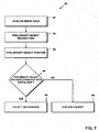
- Fig. 7 an exemplary method, generally indicated at 60, is shown in which the verifying step of the method 50 of Fig. 6 is implemented by cross-checking whether the position of the preliminarily recognized object is consistent with digital map information.
- the steps 61 and 62 of analyzing image data and preliminary object recognition are identical to steps 51 and 52, respectively.
- step 63 the object position of the preliminarily recognized object is determined. For extended objects, this step may include determining the area covered by the preliminarily recognized object.
- processing means 3 of the image recognition device 1 verifies whether the preliminary object position is consistent with the digital map. For this purpose, the processing means 3 determines in which regions of the image the object is expected to be located, as explained with reference to Fig.
- the preliminarily recognized object is verified and recognized at step 65, and the result of the image recognition may be output, e.g., to navigation system 2.
- the preliminarily recognized object is discarded at step 66. In this case, the image may be re-analyzed, i.e., process 60 may be started again.
- the width of the road determined from image data may be compared with a corresponding information stored in the digital map information, such as a width of the road or a road type, which latter typically allows one to establish a bound on the road width.
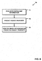
- Fig. 8 another mode of operation for image recognition device 1 will be explained next.
- the method is generally indicated at 70.
- step 71 digital map information is evaluated in order to predict a property of an object to be identified at step 72.
- This object property may be one or a combination of several of a variety of properties, including the position of the object in the image, the shape of the object in the image, or the orientation of the object in the image. If the analysis of the image data is based on fitting a model of the object to the image data, the object property may also be a prediction for one of the parameters of the model. Subsequently, at step 73, the image data is analyzed based on the predicted object property. The specific implementation of step 73 will be dependent on the object property that is predicted at step 72, and the method generally used for image data analysis.
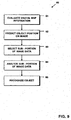
- the object to be recognized in the image is identified in the digital map, and information corresponding to the object is extracted from the digital map information. Based on this information, at step 82, the position of the object on the image is predicted. For an extended object, such as a lane marker or a road edge, the prediction of the object position will typically include identifying an extended region or area in the image in which the object is likely to be found.
- a sub-portion of the image data is selected for subsequent analysis, which sub-portion of the image data corresponds to the portion of the image in which the object is likely to be located. Referring again to Fig. 3 , these regions are schematically indicated at 29.
- the sub-portion of the image data that has been selected at step 83 is analyzed in order to recognize the object at step 85.
- the result of the image recognition i.e., the precise position and type of the recognized object, may subsequently be output to other devices, such as navigation system 2.
- the digital map information is employed to facilitate a subsequent analysis of the image data. In this way, not only the accuracy, but also the speed of the image recognition task may be improved.
- the operation of the image recognition device 1 is not restricted thereto.
- other object properties such as the shape and/or orientation of the object or an object boundary may additionally be employed to facilitate image recognition.
- the processing means 3 may then subsequently be analyzed with particular view to structures having such orientation.
- information on the object extracted from the digital map information may be used to restrict the range of possible model parameters.
- information on the distance d from the road turnoff, the angle ⁇ of the road turnoff, and the width w t of road 42 may all be employed to restrict corresponding parameters that are used for modeling the road edges of road 42 in image 40.
- the method of Fig. 9 only harnesses the prediction of the object position to facilitate the analysis of the image data
- a combination of object parameters may be employed for this purpose.
- the digital map information may allow the processing means 3 of image recognition device 1 to both predict an object position on the image and a likely shape of the object.
- the analysis of image data may not only be restricted to a sub-portion of the image data, but may further be restricted to objects located within this sub-portion and having specific shapes.
- Identifying such a relevant portion of a digital map is one of the standard features of navigation systems. More specifically, based on the output of the position determining means 8, the processing unit 6 of navigation system 2 is adapted to determine the relevant portion of the digital map that corresponds to a neighborhood of the vehicle. Further, the orientation of the vehicle relative to the map is also frequently established automatically, since the navigation system checks the motion of the vehicle.
- the relevant map portion that corresponds to the field of view of camera unit 4 may be selected and, e.g., stored in the memory means 5 of the image recognition device 1.
- the results of image recognition will be output from image recognition device 1 to a navigation system 2 in order to facilitate various navigation functionalities.
- the results provided by image recognition device 1 may in particular be employed for improving the accuracy with which the position of the vehicle is determined.
- a position determining means may include, e.g., a GPS receiver and/or a gyroscopic device.
- the accuracy of position determination achievable by these devices may, however, be insufficient in some cases.
- an analysis of the image data that leads to determining a distance of the object from the current vehicle position may be a more precise way of determining the vehicle position than the routine of the standard position determining means 8 of the navigation system.
- a precise value of the distance of the vehicle from the road turnoff may be established based on the recognized turnoff.
- the relative position is fed back into the navigation system.
- the position determining means may be recalibrated. This method, generally indicated at 90, is shown schematically in Fig. 10 .
- the position determining means 8 of the navigation system 2 determines a current vehicle position, and the navigation system 2 provides digital map information selected based on the current vehicle position to the image recognition device at step 92.
- the image recognition device identifies an object in the image according to one of the methods described above, and provides the object position to the navigation system which receives the information at step 93.
- the position determined by navigation system 2 may be recalibrated based on the input of the image recognition device.
- the image recognition device 1 of the present invention may be a modular device that comprises its own processing means and memory means as well as camera unit.
- the processing means 3 may be adapted to access a memory unit of the navigation system, in which case it is not necessary to provide a separate memory or storage unit in the image recognition device.
- the memory means could also be partially integrated with the camera unit 4, i.e., the portion of the memory means that stores image data could be a part of the camera unit.
- the image recognition device does not necessarily have to be a separate device, but may also be fully integrated, e.g., with the navigation system 2.
- the processing unit 6 of the navigation system is adapted to perform both standard navigation tasks and image recognition tasks.
- image recognition for navigation systems onboard of vehicles is anticipated to be one important field of application of the present invention
- the present invention is not restricted to this field, either. Rather, it may be applied to any situation in which objects have to be recognized in an image, and map information corresponding to at least a portion of the image is available.
Landscapes
- Engineering & Computer Science (AREA)
- Radar, Positioning & Navigation (AREA)
- Physics & Mathematics (AREA)
- General Physics & Mathematics (AREA)
- Remote Sensing (AREA)
- Theoretical Computer Science (AREA)
- Multimedia (AREA)
- Computer Vision & Pattern Recognition (AREA)
- Automation & Control Theory (AREA)
- Navigation (AREA)
- Traffic Control Systems (AREA)
- Image Analysis (AREA)
- Instructional Devices (AREA)
- Image Processing (AREA)
Claims (27)
- Verfahren zur Erkennung eines Objekts auf einem Bild, das unter Verwendung einer in einem Fahrzeug installierten Kameraeinheit (4) aufgenommen wurde, wobei das Verfahren die folgenden Schritte umfasst:Abrufen von Bilddaten, die dem Bild (20; 30; 40) entsprechen,Abrufen von digitalen Abbildungsinformationen, wobei die digitalen Abbildungsinformationen Abbildungsinformationen (25; 34; 43) auf mindestens einem Abschnitt eines Bereichs umfassen, der von dem Bild wiedergegeben wird, und wobei die digitalen Abbildungsinformationen Informationen (w; d; w, wt, d, α) zu dem Objekt (33; 45) umfassen, wobei die von den digitalen Abbildungsinformationen umfassten Informationen (w; d; w, wt, d, α) zu dem Objekt (33; 45) Informationen zu einer Position des Objekts (33;45) enthalten,Auswertung der Bilddaten und der digitalen Abbildungsinformationen (25; 34; 43) zur Erkennung des Objekts (33; 45), wobei sowohl die Bilddaten als auch die digitalen Abbildungsinformationen zur Erkennung des Objekts (33; 45) ausgewertet werden, undBereitstellen eines Ergebnisses der Auswertung der Bilddaten und der digitalen Abbildungsinformationen für ein Navigationssystem (2),dadurch gekennzeichnet, dass das Ergebnis der Auswertung, das dem Navigationssystem (2) bereitgestellt wird, Informationen zu einem Abstand des Objekts (33; 45) von einer derzeitigen Fahrzeugposition des Fahrzeugs beinhaltet, unddass die Auswertung der Bilddaten auf einen Unterabschnitt (29) der Bilddaten beschränkt ist, der basierend auf den Informationen zur Position des Objekts (33; 45) ausgewählt wird.
- Verfahren nach Anspruch 1, dadurch gekennzeichnet, dass die Auswertung der Bilddaten und der digitalen Abbildungsinformationen die Auswertung der Bilddaten zur Erkennung des Objekts (33; 45) und das anschließende Überprüfen, basierend auf den digitalen Abbildungsinformationen, ob das Objekt (33; 45) richtig erkannt wurde, beinhaltet.
- Verfahren nach Anspruch 1 oder 2, dadurch gekennzeichnet, dass die von den digitalen Abbildungsinformationen umfassten Informationen (w; d; w, wt, d, α) zu dem Objekt (33; 45) Informationen zu einer Gestalt und/oder zu einer Ausrichtung des Objekts (33; 45) beinhalten, und
dass die Auswertung der Bilddaten und der digitalen Abbildungsinformationen die Auswertung der Bilddaten zur Erkennung des Objekts (33; 45), das Bestimmen einer Gestalt und/oder einer Ausrichtung des Objekts (33; 45) anhand der Bilddaten und das Vergleichen der anhand der Bilddaten bestimmten Gestalt und/oder Ausrichtung des Objekts (33; 45) mit den digitalen Abbildungsinformationen beinhaltet. - Verfahren nach einem der vorhergehenden Ansprüche, dadurch gekennzeichnet, dass die von den digitalen Abbildungsinformationen umfassten Informationen (w; d; w, wt, d, α) zu dem Objekt (33; 45) Informationen zu der Gestalt und/oder der Ausrichtung des Objekts (33; 45) beinhalten,
wobei die Auswertung der Bilddaten auf das Identifizieren von Objekten (33; 45) beschränkt ist, die Gestalten und/oder Ausrichtungen aufweisen, die basierend auf den Informationen zu Gestalt und/oder Ausrichtung des Objekts (33; 45) ausgewählt wurden. - Verfahren nach einem der vorhergehenden Ansprüche, dadurch gekennzeichnet, dass die Auswertung der Bilddaten und der digitalen Abbildungsinformationen das Vergleichen eines Modells des Objekts (33; 45) mit den Bilddaten beinhaltet.
- Verfahren nach Anspruch 5, dadurch gekennzeichnet, dass das Modell des Objekts (33; 45) mindestens einen variablen Parameter aufweist und dass die Auswertung der Bilddaten und der digitalen Abbildungsinformationen das Finden eines optimalen Werts für den mindestens einen variablen Parameter beinhaltet.
- Verfahren nach Anspruch 6, dadurch gekennzeichnet, dass das Finden des optimalen Werts für den mindestens einen variablen Parameter bayessches Filtern oder Teilchenfiltern beinhaltet.
- Verfahren nach einem der vorhergehenden Ansprüche, dadurch gekennzeichnet, dass die digitalen Abbildungsinformationen aus dem Navigationssystem (2) abgerufen werden.
- Verfahren nach einem der vorhergehenden Ansprüche, dadurch gekennzeichnet, dass das Verfahren das Bestimmen der derzeitigen Fahrzeugposition (27; 38; 46) umfasst, wobei das Abrufen der digitalen Abbildungsinformationen auf der derzeitigen Fahrzeugposition (27; 38; 46) basiert.
- Verfahren nach Anspruch 9, dadurch gekennzeichnet, dass das Verfahren das Bestimmen einer derzeitigen Fahrzeugausrichtung umfasst, wobei das Abrufen der digitalen Abbildungsinformationen auf der derzeitigen Fahrzeugausrichtung basiert.
- Verfahren nach einem der vorhergehenden Ansprüche, dadurch gekennzeichnet, dass das Verfahren das Aufnehmen des Bilds (20; 30; 40) umfasst, wobei das Bild (20; 30; 40) eine Umgebung eines Fahrzeugs zeigt.
- Verfahren nach einem der vorhergehenden Ansprüche, dadurch gekennzeichnet, dass das Verfahren das Nachkalibrieren eines Positionsbestimmungsmittels (8) der Navigationsvorrichtung (2) basierend auf einem Vergleich eines anhand der digitalen Abbildungsinformationen festgelegten Abstands und der Ausgabe des Positionsbestimmungsmittels (8) mit dem anhand der Bilddaten festgelegten Abstand umfasst.
- Verfahren nach einem der vorhergehenden Ansprüche, dadurch gekennzeichnet, dass das Verfahren das Bereitstellen von Fahranweisungen für einen Fahrer oder das Warnen eines Fahrers oder das Steuern eines Fahrzeugs basierend auf einem Ergebnis der Auswertung der Bilddaten und der digitalen Abbildungsinformationen umfasst.
- Verfahren nach einem der vorhergehenden Ansprüche, dadurch gekennzeichnet, dass das Objekt (33; 45) aus einer Gruppe ausgewählt ist, die eine Straßenkreuzung, eine Straßenabbiegung (42, 45) und ein Verkehrsschild umfasst.
- Bilderkennungsvorrichtung zur Erkennung eines Objekts (33; 45) in einem Bild, umfassend
eine in einem Fahrzeug (10) installierte Kameraeinheit (4), die dazu ausgelegt ist, das Bild (20; 30; 40) aufzunehmen,
ein Speichermittel (5) zum Speichern von dem Bild (20; 30; 40) entsprechenden Bilddaten und zum Speichern von digitalen Abbildungsinformationen, wobei die digitalen Abbildungsinformationen Abbildungsinformationen (25; 34; 43) auf mindestens einem Abschnitt eines Bereichs umfassen, der von dem Bild wiedergegeben wird, und wobei die digitalen Abbildungsinformationen Informationen (w; d; w, wt, d, α) zu dem Objekt (33; 45) umfassen, wobei die von den digitalen Abbildungsinformationen umfassten Informationen (w; d; w, wt, d, α) zu dem Objekt (33; 45) Informationen zu einer Position des Objekts (33; 45) beinhalten, und
ein Verarbeitungsmittel (3), das an das Speichermittel (5) gekoppelt ist und das dazu ausgelegt ist, eine Auswertung der Bilddaten und der digitalen Abbildungsinformationen zur Erkennung des Objekts (33; 45) durchzuführen, wobei sowohl die Bilddaten als auch die digitalen Abbildungsinformationen zur Erkennung des Objekts (33; 45) ausgewertet werden, wobei die Bilderkennungsvorrichtung (1) dazu ausgelegt ist, einem Navigationssystem (2) ein Ergebnis der Auswertung der Bilddaten und der digitalen Abbildungsinformationen bereitzustellen,
dadurch gekennzeichnet, dass das dem Navigationssystem (2) bereitgestellte Ergebnis der Auswertung Informationen zu einem Abstand des Objekts (33; 45) von einer derzeitigen Fahrzeugposition des Fahrzeugs beinhaltet, und
dass das Verarbeitungsmittel (3) dazu ausgelegt ist, die Auswertung nur an einem Unterabschnitt (29) der Bilddaten basierend auf den Informationen zu der Position des Objekts (33; 45) durchzuführen. - Bilderkennungsvorrichtung nach Anspruch 15, dadurch gekennzeichnet, dass das Verarbeitungsmittel (3) die Bilddaten zur Erkennung des Objekts (33; 45) auswertet und anschließend basierend auf den digitalen Abbildungsinformationen überprüft, ob das Objekt (33; 45) richtig erkannt wurde.
- Bilderkennungsvorrichtung nach Anspruch 15 oder 16, dadurch gekennzeichnet, dass die von den digitalen Abbildungsinformationen umfassten Informationen (w; d; w, wt, d, α) zu dem Objekt (33; 45) Informationen zu einer Gestalt und/oder Ausrichtung des Objekts (33; 45) beinhalten, und
das Verarbeitungsmittel (3) die Bilddaten zur Erkennung des Objekts (33; 45) auswertet, eine Gestalt und/oder Ausrichtung des Objekts (33; 45) anhand der Bilddaten bestimmt und eine anhand der Bilddaten bestimmte Gestalt und/oder Ausrichtung des Objekts (33; 45) mit den digitalen Abbildungsinformationen vergleicht. - Bilderkennungsvorrichtung nach einem der Ansprüche 15-17, dadurch gekennzeichnet, dass das Verarbeitungsmittel (3) ein Modell des Objekts (33; 45) mit den Bilddaten zur Erkennung des Objekts (33; 45) vergleicht.
- Bilderkennungsvorrichtung nach Anspruch 18, dadurch gekennzeichnet, dass das Modell des Objekts (33; 45) mindestens einen variablen Parameter aufweist und dass das Verarbeitungsmittel (3) einen optimalen Wert für den mindestens einen variablen Parameter findet.
- Bilderkennungsvorrichtung nach Anspruch 19, dadurch gekennzeichnet, dass das Verarbeitungsmittel (3) einen bayesschen Filter oder Teilchenfilter zum Finden des optimalen Werts für den mindestens einen variablen Parameter verwendet.
- Bilderkennungsvorrichtung nach einem der Ansprüche 15-20, dadurch gekennzeichnet, dass die Vorrichtung ein Positionsbestimmungsmittel (8) zum Bestimmen der derzeitigen Fahrzeugposition (27; 38; 46) umfasst,
wobei das Positionsbestimmungsmittel (8) an das Verarbeitungsmittel (3) gekoppelt ist und das Verarbeitungsmittel (3) dazu ausgelegt ist, einen Teil der digitalen Abbildungsinformationen basierend auf der derzeitigen Fahrzeugposition auszuwählen. - Bilderkennungsvorrichtung nach Anspruch 21, dadurch gekennzeichnet, dass die Vorrichtung Ausrichtungsbestimmungsmittel (6, 8) zum Bestimmen einer derzeitigen Fahrzeugausrichtung umfasst,
wobei die Ausrichtungsbestimmungsmittel (6, 8) an das Verarbeitungsmittel (3) gekoppelt sind und das Verarbeitungsmittel (3) dazu ausgelegt ist, einen Teil der digitalen Abbildungsinformationen basierend auf der derzeitigen Fahrzeugausrichtung auszuwählen. - Bilderkennungsvorrichtung nach einem der Ansprüche 15-22, dadurch gekennzeichnet, dass die Kameraeinheit an das Speichermittel (5) gekoppelt ist, um dem Speichermittel (5) das Bild bereitzustellen.
- Navigationssystem und Bilderkennungsvorrichtungsaufbau, umfassend die Bilderkennungsvorrichtung (1) nach einem der Ansprüche 15-23.
- Navigationssystem und Bilderkennungsvorrichtungsaufbau nach Anspruch 24, umfassend
eine Speichereinheit (7) zum Speichern einer digitalen Abbildung, wobei die Bilderkennungsvorrichtung (1) an die Speichereinheit (7) gekoppelt ist, um mindestens einen Teil der digitalen Abbildung daraus abzurufen. - Navigationssystem und Bilderkennungsvorrichtungsaufbau nach Anspruch 24 oder 25, umfassend
eine optische oder akustische Ausgabeeinheit (9) zur Ausgabe von Fahranweisungen oder Warnsignalen an einen Fahrer,
wobei die Fahranweisungen oder Warnsignale in Abhängigkeit von dem Objekt (33; 45), das von der Bilderkennungsvorrichtung (1) erkannt wird, ausgegeben werden. - Navigationssystem und Bilderkennungsvorrichtungsaufbau nach einem der Ansprüche 24-26,
wobei das Navigationssystem (2) ein Positionsbestimmungsmittel (8) zum Bestimmen der derzeitigen Fahrzeugposition umfasst,
wobei die Bilderkennungsvorrichtung (1) dem Positionsbestimmungsmittel (8) Positionsinformationen zu dem erkannten Objekt (33; 45) bereitstellt und das Positionsbestimmungsmittel (8) die Genauigkeit der Positionsbestimmung basierend auf den Positionsinformationen zu dem erkannten Objekt (33; 45) verbessert.
Priority Applications (6)
| Application Number | Priority Date | Filing Date | Title |
|---|---|---|---|
| EP06018335.7A EP1906339B1 (de) | 2006-09-01 | 2006-09-01 | Verfahren zur Erkennung eines Objekts auf einem Bild und Bilderkennungsvorrichtung |
| CA2598162A CA2598162C (en) | 2006-09-01 | 2007-08-21 | Method for recognizing an object in an image and image recognition device |
| JP2007225633A JP2008059593A (ja) | 2006-09-01 | 2007-08-31 | 画像における対象物を認識する方法および画像認識デバイス |
| CN2007101676609A CN101159014B (zh) | 2006-09-01 | 2007-08-31 | 在图像中识别对象的方法和图像识别设备 |
| KR1020070088708A KR20080020971A (ko) | 2006-09-01 | 2007-09-01 | 이미지에서 물체를 인식하기 위한 방법 및 이미지 인식 장치 |
| US11/849,641 US8311274B2 (en) | 2006-09-01 | 2007-09-04 | Image recognition system |
Applications Claiming Priority (1)
| Application Number | Priority Date | Filing Date | Title |
|---|---|---|---|
| EP06018335.7A EP1906339B1 (de) | 2006-09-01 | 2006-09-01 | Verfahren zur Erkennung eines Objekts auf einem Bild und Bilderkennungsvorrichtung |
Publications (2)
| Publication Number | Publication Date |
|---|---|
| EP1906339A1 EP1906339A1 (de) | 2008-04-02 |
| EP1906339B1 true EP1906339B1 (de) | 2016-01-13 |
Family
ID=37885931
Family Applications (1)
| Application Number | Title | Priority Date | Filing Date |
|---|---|---|---|
| EP06018335.7A Not-in-force EP1906339B1 (de) | 2006-09-01 | 2006-09-01 | Verfahren zur Erkennung eines Objekts auf einem Bild und Bilderkennungsvorrichtung |
Country Status (6)
| Country | Link |
|---|---|
| US (1) | US8311274B2 (de) |
| EP (1) | EP1906339B1 (de) |
| JP (1) | JP2008059593A (de) |
| KR (1) | KR20080020971A (de) |
| CN (1) | CN101159014B (de) |
| CA (1) | CA2598162C (de) |
Families Citing this family (83)
| Publication number | Priority date | Publication date | Assignee | Title |
|---|---|---|---|---|
| US7881497B2 (en) * | 2007-03-08 | 2011-02-01 | Honeywell International Inc. | Vision based navigation and guidance system |
| US9200901B2 (en) | 2008-06-19 | 2015-12-01 | Microsoft Technology Licensing, Llc | Predictive services for devices supporting dynamic direction information |
| US8700301B2 (en) * | 2008-06-19 | 2014-04-15 | Microsoft Corporation | Mobile computing devices, architecture and user interfaces based on dynamic direction information |
| US20090315775A1 (en) * | 2008-06-20 | 2009-12-24 | Microsoft Corporation | Mobile computing services based on devices with dynamic direction information |
| US20090319166A1 (en) * | 2008-06-20 | 2009-12-24 | Microsoft Corporation | Mobile computing services based on devices with dynamic direction information |
| US8467991B2 (en) | 2008-06-20 | 2013-06-18 | Microsoft Corporation | Data services based on gesture and location information of device |
| US8391615B2 (en) * | 2008-12-02 | 2013-03-05 | Intel Corporation | Image recognition algorithm, method of identifying a target image using same, and method of selecting data for transmission to a portable electronic device |
| FR2939325B1 (fr) * | 2008-12-04 | 2015-10-16 | Parrot | Systeme de drones munis de balises de reconnaissance |
| US8319666B2 (en) | 2009-02-20 | 2012-11-27 | Appareo Systems, Llc | Optical image monitoring system and method for vehicles |
| US8319665B2 (en) * | 2009-02-20 | 2012-11-27 | Appareo Systems, Llc | Adaptive instrument and operator control recognition |
| US20100228612A1 (en) * | 2009-03-09 | 2010-09-09 | Microsoft Corporation | Device transaction model and services based on directional information of device |
| US20100332324A1 (en) * | 2009-06-25 | 2010-12-30 | Microsoft Corporation | Portal services based on interactions with points of interest discovered via directional device information |
| US8872767B2 (en) | 2009-07-07 | 2014-10-28 | Microsoft Corporation | System and method for converting gestures into digital graffiti |
| DE102009049849B4 (de) * | 2009-10-19 | 2020-09-24 | Apple Inc. | Verfahren zur Bestimmung der Pose einer Kamera, Verfahren zur Erkennung eines Objekts einer realen Umgebung und Verfahren zur Erstellung eines Datenmodells |
| KR101117239B1 (ko) * | 2010-01-12 | 2012-03-20 | 키위플 주식회사 | 객체 인식시스템 및 이를 이용하는 객체 인식 방법 |
| US8791996B2 (en) * | 2010-03-31 | 2014-07-29 | Aisin Aw Co., Ltd. | Image processing system and position measurement system |
| JP5832432B2 (ja) * | 2010-06-15 | 2015-12-16 | 株式会社ナビタイムジャパン | ナビゲーションシステム、ナビゲーション方法、および、プログラム |
| WO2011158352A1 (ja) * | 2010-06-16 | 2011-12-22 | 株式会社ナビタイムジャパン | ナビゲーションシステム、端末装置、ナビゲーションサーバ、ナビゲーション装置、ナビゲーション方法、および、プログラム |
| WO2011160672A1 (en) * | 2010-06-21 | 2011-12-29 | Centre De Visió Per Computador | Method for obtaining drivable road area |
| US8509982B2 (en) | 2010-10-05 | 2013-08-13 | Google Inc. | Zone driving |
| EP2450667B1 (de) | 2010-11-09 | 2016-11-02 | Harman Becker Automotive Systems GmbH | Visionssystem und Verfahren zur Analysierung eines Bilds |
| DE102010062633A1 (de) * | 2010-12-08 | 2012-06-14 | Robert Bosch Gmbh | Verfahren und Vorrichtung zur Erkennung von Verkehrszeichen in der Umgebung eines Fahrzeuges und Abgleich mit Verkehrszeicheninformationen aus einer digitalen Karte |
| CN102955931B (zh) * | 2011-08-19 | 2015-11-25 | 株式会社理光 | 识别图像中特定对象的方法以及使用该方法的系统 |
| DE102011112404B4 (de) * | 2011-09-03 | 2014-03-20 | Audi Ag | Verfahren zum Bestimmen der Position eines Kraftfahrzeugs |
| DE102011118161B3 (de) | 2011-11-10 | 2013-03-28 | Audi Ag | Verfahren zur Positionsbestimmung |
| US20130128050A1 (en) * | 2011-11-22 | 2013-05-23 | Farzin Aghdasi | Geographic map based control |
| US9043133B2 (en) * | 2011-12-29 | 2015-05-26 | Intel Corporation | Navigation systems and associated methods |
| US10607424B2 (en) | 2012-02-10 | 2020-03-31 | Appareo Systems, Llc | Frequency-adaptable structural health and usage monitoring system (HUMS) and method with smart sensors |
| WO2013120103A1 (en) | 2012-02-10 | 2013-08-15 | Appareo Systems, Llc | Frequency-adaptable structural health and usage monitoring system |
| DE102012207203A1 (de) * | 2012-04-30 | 2013-10-31 | Robert Bosch Gmbh | Verfahren und Vorrichtung zur Bestimmung eines Umfelds |
| JP5960506B2 (ja) * | 2012-05-25 | 2016-08-02 | 株式会社デンソー | 交差点認識装置及び道路種別認識装置 |
| US8988556B1 (en) * | 2012-06-15 | 2015-03-24 | Amazon Technologies, Inc. | Orientation-assisted object recognition |
| US9056395B1 (en) | 2012-09-05 | 2015-06-16 | Google Inc. | Construction zone sign detection using light detection and ranging |
| US8996228B1 (en) | 2012-09-05 | 2015-03-31 | Google Inc. | Construction zone object detection using light detection and ranging |
| US9195914B2 (en) | 2012-09-05 | 2015-11-24 | Google Inc. | Construction zone sign detection |
| US9221461B2 (en) * | 2012-09-05 | 2015-12-29 | Google Inc. | Construction zone detection using a plurality of information sources |
| CN103090875A (zh) * | 2012-11-26 | 2013-05-08 | 华南理工大学 | 一种基于双摄像头的实时实景匹配车载导航方法及装置 |
| WO2014115563A1 (ja) | 2013-01-28 | 2014-07-31 | 日本電気株式会社 | 運転支援装置、運転支援方法、および運転支援プログラムを記憶する記録媒体 |
| DE102013011827A1 (de) | 2013-07-15 | 2015-01-15 | Audi Ag | Verfahren zum Betrieb einer Navigationseinrichtung, Navigationseinrichtung und Kraftfahrzeug |
| SE538984C2 (sv) * | 2013-07-18 | 2017-03-14 | Scania Cv Ab | Fastställande av körfältsposition |
| US9597002B2 (en) * | 2013-08-21 | 2017-03-21 | Gsacore, Llc | Systems, methods, and uses of a Bayes-optimal nonlinear filtering algorithm |
| JP5892129B2 (ja) * | 2013-08-29 | 2016-03-23 | 株式会社デンソー | 道路形状認識方法、道路形状認識装置、プログラムおよび記録媒体 |
| US9495602B2 (en) | 2013-10-23 | 2016-11-15 | Toyota Motor Engineering & Manufacturing North America, Inc. | Image and map-based detection of vehicles at intersections |
| WO2015077766A1 (en) * | 2013-11-25 | 2015-05-28 | Pcms Holdings, Inc. | Systems and methods for providing augmenting reality information associated with signage |
| US9395192B1 (en) * | 2013-12-20 | 2016-07-19 | Google Inc. | Methods and systems for road and lane boundary tracing |
| US9081383B1 (en) * | 2014-01-22 | 2015-07-14 | Google Inc. | Enhancing basic roadway-intersection models using high intensity image data |
| EP3147629B1 (de) * | 2014-05-20 | 2019-07-10 | Nissan Motor Co., Ltd | Objekterkennungsvorrichtung und objekterkennungsverfahren |
| KR20160006909A (ko) | 2014-07-10 | 2016-01-20 | 김진곤 | 이미지 처리 방법과 이를 저장하는 저장 매체 |
| US9321461B1 (en) | 2014-08-29 | 2016-04-26 | Google Inc. | Change detection using curve alignment |
| US9248834B1 (en) | 2014-10-02 | 2016-02-02 | Google Inc. | Predicting trajectories of objects based on contextual information |
| EP3032221B1 (de) * | 2014-12-09 | 2022-03-30 | Volvo Car Corporation | Verfahren und Vorrichtung zum Erhöhen der Genauigkeit von digitalen Kartendaten, die von einem Fahrzeug verwendet werden |
| CN105760390B (zh) * | 2014-12-17 | 2021-09-28 | 富泰华工业(深圳)有限公司 | 图片检索系统及方法 |
| US11370422B2 (en) * | 2015-02-12 | 2022-06-28 | Honda Research Institute Europe Gmbh | Method and system in a vehicle for improving prediction results of an advantageous driver assistant system |
| JP6519355B2 (ja) * | 2015-06-30 | 2019-05-29 | 株式会社デンソー | カメラ装置及び車載システム |
| DE102015214743A1 (de) * | 2015-08-03 | 2017-02-09 | Audi Ag | Verfahren und Vorrichtung in einem Kraftfahrzeug zur verbesserten Datenfusionierung bei einer Umfelderfassung |
| CN105678257A (zh) * | 2016-01-06 | 2016-06-15 | 北京卓视智通科技有限责任公司 | 一种交通调查车型识别方法、装置及其系统 |
| US10291348B2 (en) | 2016-02-02 | 2019-05-14 | Bao Tran | Systems and methods for control of drones |
| US9835709B2 (en) | 2016-02-02 | 2017-12-05 | Bao Tran | Systems and methods for permission based control of robots |
| US10034066B2 (en) | 2016-05-02 | 2018-07-24 | Bao Tran | Smart device |
| KR20160085742A (ko) | 2016-07-11 | 2016-07-18 | 김진곤 | 이미지 처리 방법 |
| EP3285203A1 (de) * | 2016-08-19 | 2018-02-21 | Continental Automotive GmbH | Verfahren zum detektion einer strasse in einer umgebung eines fahrzeugs |
| US10739142B2 (en) | 2016-09-02 | 2020-08-11 | Apple Inc. | System for determining position both indoor and outdoor |
| CN106323323B (zh) * | 2016-11-14 | 2019-02-15 | 深圳市深水水务咨询有限公司 | 一种区域确定方法和装置 |
| KR20180068578A (ko) * | 2016-12-14 | 2018-06-22 | 삼성전자주식회사 | 복수의 센서를 이용하여 객체를 인식하는 전자 기기 및 방법 |
| KR102751144B1 (ko) * | 2016-12-16 | 2025-01-08 | 현대자동차주식회사 | 차량 및 차량의 제어방법 |
| DE102016015513A1 (de) * | 2016-12-23 | 2018-06-28 | Lucas Automotive Gmbh | Fahrassistenz-System eines Kraftfahrzeugs |
| US20180270413A1 (en) * | 2017-03-15 | 2018-09-20 | Kabushiki Kaisha Toshiba | Processing apparatus and processing system |
| US10509409B2 (en) * | 2017-04-27 | 2019-12-17 | Aptiv Technologies Limited | Local traffic customs learning system for automated vehicle |
| US10289115B2 (en) * | 2017-06-01 | 2019-05-14 | Aptiv Technologies Limited | Automated vehicle map localization based on observed geometries of roadways |
| JP7037317B2 (ja) * | 2017-09-28 | 2022-03-16 | 株式会社Subaru | 自車位置検出装置 |
| US10895460B2 (en) * | 2017-11-06 | 2021-01-19 | Cybernet Systems Corporation | System and method for generating precise road lane map data |
| US11126846B2 (en) * | 2018-01-18 | 2021-09-21 | Ebay Inc. | Augmented reality, computer vision, and digital ticketing systems |
| DE102018204500A1 (de) * | 2018-03-23 | 2019-09-26 | Continental Automotive Gmbh | System zur Erzeugung von Konfidenzwerten im Backend |
| US20190354781A1 (en) * | 2018-05-17 | 2019-11-21 | GM Global Technology Operations LLC | Method and system for determining an object location by using map information |
| CN110648545A (zh) * | 2018-06-26 | 2020-01-03 | 上海擎感智能科技有限公司 | 一种新交通规则的提醒方法、系统及车载终端 |
| DE102018119026A1 (de) * | 2018-08-06 | 2020-02-06 | Knorr-Bremse Systeme für Nutzfahrzeuge GmbH | Kameraüberwachungssystem |
| CN110942603B (zh) * | 2018-09-21 | 2021-09-17 | 北汽福田汽车股份有限公司 | 车辆碰撞报警方法、装置、车辆和服务器 |
| JP7254664B2 (ja) * | 2019-08-27 | 2023-04-10 | 日立Astemo株式会社 | 演算装置 |
| CN110717395A (zh) * | 2019-09-06 | 2020-01-21 | 平安城市建设科技(深圳)有限公司 | 图片物体处理方法、装置及存储介质 |
| CN111775953A (zh) * | 2019-12-16 | 2020-10-16 | 王忠亮 | 驾驶状态即时修正系统及方法 |
| JP7248957B2 (ja) * | 2020-02-10 | 2023-03-30 | トヨタ自動車株式会社 | 車両制御装置 |
| IT202100033116A1 (it) * | 2021-12-30 | 2023-06-30 | Prinoth Spa | Veicolo cingolato e metodo di localizzazione di un veicolo cingolato |
| EP4224433A1 (de) * | 2022-02-03 | 2023-08-09 | Zenseact AB | Trainieren eines wahrnehmungsmodells für ein fahrzeug |
Citations (1)
| Publication number | Priority date | Publication date | Assignee | Title |
|---|---|---|---|---|
| WO2006080547A1 (en) * | 2005-01-28 | 2006-08-03 | Aisin Aw Co., Ltd. | Image recognizing apparatus and method, and position determining apparatus, vehicle controlling apparatus and navigation apparatus using the image recognizing apparatus or method |
Family Cites Families (14)
| Publication number | Priority date | Publication date | Assignee | Title |
|---|---|---|---|---|
| JPH0935198A (ja) * | 1995-07-14 | 1997-02-07 | Mitsubishi Electric Corp | 車両用走行路検出装置 |
| DE19842176A1 (de) * | 1998-09-15 | 2000-03-16 | Bosch Gmbh Robert | Verfahren und Vorrichtung zur Verkehrszeichenerkennung und Navigation |
| US6671615B1 (en) * | 2000-05-02 | 2003-12-30 | Navigation Technologies Corp. | Navigation system with sign assistance |
| JP2004507724A (ja) * | 2000-08-24 | 2004-03-11 | シーメンス アクチエンゲゼルシヤフト | 目標情報を表示させるための方法、地図画面内でナビゲーションを行う方法、コンピュータプログラム製品及びナビゲーション装置 |
| JP4236372B2 (ja) * | 2000-09-25 | 2009-03-11 | インターナショナル・ビジネス・マシーンズ・コーポレーション | 空間情報利用システムおよびサーバシステム |
| JP2002243469A (ja) * | 2001-02-19 | 2002-08-28 | Alpine Electronics Inc | ナビゲーション装置および地図データベース更新システム |
| JP4327389B2 (ja) * | 2001-10-17 | 2009-09-09 | 株式会社日立製作所 | 走行レーン認識装置 |
| JP3958133B2 (ja) * | 2002-07-12 | 2007-08-15 | アルパイン株式会社 | 車両位置測定装置および方法 |
| JP4370869B2 (ja) * | 2003-09-25 | 2009-11-25 | トヨタ自動車株式会社 | 地図データ更新方法および地図データ更新装置 |
| JP2005315851A (ja) * | 2004-03-31 | 2005-11-10 | Denso Corp | カーナビゲーション装置 |
| JP4292250B2 (ja) * | 2004-07-02 | 2009-07-08 | トヨタ自動車株式会社 | 道路環境認識方法及び道路環境認識装置 |
| JP2006151014A (ja) * | 2004-11-25 | 2006-06-15 | Denso Corp | 安全運転支援システム |
| JP2006164197A (ja) * | 2004-12-10 | 2006-06-22 | Equos Research Co Ltd | 走行支援装置 |
| JP2006226824A (ja) * | 2005-02-17 | 2006-08-31 | Toyota Motor Corp | 車両用情報報知装置 |
-
2006
- 2006-09-01 EP EP06018335.7A patent/EP1906339B1/de not_active Not-in-force
-
2007
- 2007-08-21 CA CA2598162A patent/CA2598162C/en active Active
- 2007-08-31 CN CN2007101676609A patent/CN101159014B/zh active Active
- 2007-08-31 JP JP2007225633A patent/JP2008059593A/ja active Pending
- 2007-09-01 KR KR1020070088708A patent/KR20080020971A/ko not_active Ceased
- 2007-09-04 US US11/849,641 patent/US8311274B2/en active Active
Patent Citations (1)
| Publication number | Priority date | Publication date | Assignee | Title |
|---|---|---|---|---|
| WO2006080547A1 (en) * | 2005-01-28 | 2006-08-03 | Aisin Aw Co., Ltd. | Image recognizing apparatus and method, and position determining apparatus, vehicle controlling apparatus and navigation apparatus using the image recognizing apparatus or method |
Also Published As
| Publication number | Publication date |
|---|---|
| JP2008059593A (ja) | 2008-03-13 |
| US8311274B2 (en) | 2012-11-13 |
| EP1906339A1 (de) | 2008-04-02 |
| KR20080020971A (ko) | 2008-03-06 |
| CN101159014A (zh) | 2008-04-09 |
| CN101159014B (zh) | 2013-04-17 |
| CA2598162A1 (en) | 2008-03-01 |
| US20080056535A1 (en) | 2008-03-06 |
| CA2598162C (en) | 2013-07-16 |
Similar Documents
| Publication | Publication Date | Title |
|---|---|---|
| EP1906339B1 (de) | Verfahren zur Erkennung eines Objekts auf einem Bild und Bilderkennungsvorrichtung | |
| CN110174856B (zh) | 车辆的驾驶模式切换控制设备和方法以及车辆系统 | |
| CN110210280B (zh) | 一种超视距感知方法、系统、终端和存储介质 | |
| US10380890B2 (en) | Autonomous vehicle localization based on walsh kernel projection technique | |
| CN106043293B (zh) | 用于安全地停放车辆的方法和装置 | |
| US20220270358A1 (en) | Vehicular sensor system calibration | |
| US8620032B2 (en) | System and method for traffic signal detection | |
| US20090248284A1 (en) | Travel support system and travel support method | |
| CN105807762A (zh) | 在虚拟环境中改进的自主驾驶 | |
| WO2011053335A1 (en) | System and method of detecting, populating and/or verifying condition, attributions, and/or objects along a navigable street network | |
| JP2003123197A (ja) | 道路標示等認識装置 | |
| KR102266996B1 (ko) | 이미지센서와 함께 회전 감지용 센서 또는 위치 센서를 장착한 모바일 시스템에서의 객체인식영역 제한 방법 및 장치 | |
| CN115082536B (zh) | 一种适用于非结构化道路场景下高精度地图的构建方法 | |
| CN113942503B (zh) | 一种车道保持方法和装置 | |
| CN112124304B (zh) | 一种库位定位方法、装置及车载设备 | |
| CN115917619A (zh) | 信息处理装置 | |
| CN115050203B (zh) | 地图生成装置以及车辆位置识别装置 | |
| JP4296287B2 (ja) | 車両認識装置 | |
| JP5888275B2 (ja) | 道路端検出システム、方法およびプログラム | |
| JP6611315B2 (ja) | 映像基準点決定システム、映像基準点決定方法および映像基準点決定プログラム | |
| JP5874602B2 (ja) | 退出道路案内システム、方法およびプログラム | |
| JPH07271978A (ja) | 画像処理装置 | |
| JP7686990B2 (ja) | 道路区画線認識装置及び方法、電子機器 | |
| CN116894871A (zh) | 地图生成装置 | |
| JP3081788B2 (ja) | 局地的位置把握装置 |
Legal Events
| Date | Code | Title | Description |
|---|---|---|---|
| PUAI | Public reference made under article 153(3) epc to a published international application that has entered the european phase |
Free format text: ORIGINAL CODE: 0009012 |
|
| 17P | Request for examination filed |
Effective date: 20070907 |
|
| AK | Designated contracting states |
Kind code of ref document: A1 Designated state(s): AT BE BG CH CY CZ DE DK EE ES FI FR GB GR HU IE IS IT LI LT LU LV MC NL PL PT RO SE SI SK TR |
|
| AX | Request for extension of the european patent |
Extension state: AL BA HR MK YU |
|
| AKX | Designation fees paid |
Designated state(s): AT BE BG CH CY CZ DE DK EE ES FI FR GB GR HU IE IS IT LI LT LU LV MC NL PL PT RO SE SI SK TR |
|
| 17Q | First examination report despatched |
Effective date: 20121113 |
|
| REG | Reference to a national code |
Ref country code: DE Ref legal event code: R079 Ref document number: 602006047703 Country of ref document: DE Free format text: PREVIOUS MAIN CLASS: G06K0009460000 Ipc: G01C0021300000 |
|
| RIC1 | Information provided on ipc code assigned before grant |
Ipc: G06K 9/00 20060101ALI20150119BHEP Ipc: G06T 7/00 20060101ALI20150119BHEP Ipc: G06K 9/46 20060101ALI20150119BHEP Ipc: G01C 21/30 20060101AFI20150119BHEP |
|
| GRAP | Despatch of communication of intention to grant a patent |
Free format text: ORIGINAL CODE: EPIDOSNIGR1 |
|
| INTG | Intention to grant announced |
Effective date: 20150716 |
|
| RIN1 | Information on inventor provided before grant (corrected) |
Inventor name: MOHR, ULRICH Inventor name: BERGMANN, STEPHAN |
|
| GRAS | Grant fee paid |
Free format text: ORIGINAL CODE: EPIDOSNIGR3 |
|
| GRAA | (expected) grant |
Free format text: ORIGINAL CODE: 0009210 |
|
| AK | Designated contracting states |
Kind code of ref document: B1 Designated state(s): AT BE BG CH CY CZ DE DK EE ES FI FR GB GR HU IE IS IT LI LT LU LV MC NL PL PT RO SE SI SK TR |
|
| REG | Reference to a national code |
Ref country code: GB Ref legal event code: FG4D |
|
| REG | Reference to a national code |
Ref country code: CH Ref legal event code: EP |
|
| REG | Reference to a national code |
Ref country code: IE Ref legal event code: FG4D |
|
| REG | Reference to a national code |
Ref country code: AT Ref legal event code: REF Ref document number: 770826 Country of ref document: AT Kind code of ref document: T Effective date: 20160215 |
|
| REG | Reference to a national code |
Ref country code: DE Ref legal event code: R096 Ref document number: 602006047703 Country of ref document: DE |
|
| REG | Reference to a national code |
Ref country code: LT Ref legal event code: MG4D |
|
| REG | Reference to a national code |
Ref country code: NL Ref legal event code: MP Effective date: 20160113 |
|
| REG | Reference to a national code |
Ref country code: AT Ref legal event code: MK05 Ref document number: 770826 Country of ref document: AT Kind code of ref document: T Effective date: 20160113 |
|
| PG25 | Lapsed in a contracting state [announced via postgrant information from national office to epo] |
Ref country code: NL Free format text: LAPSE BECAUSE OF FAILURE TO SUBMIT A TRANSLATION OF THE DESCRIPTION OR TO PAY THE FEE WITHIN THE PRESCRIBED TIME-LIMIT Effective date: 20160113 |
|
| PG25 | Lapsed in a contracting state [announced via postgrant information from national office to epo] |
Ref country code: ES Free format text: LAPSE BECAUSE OF FAILURE TO SUBMIT A TRANSLATION OF THE DESCRIPTION OR TO PAY THE FEE WITHIN THE PRESCRIBED TIME-LIMIT Effective date: 20160113 Ref country code: FI Free format text: LAPSE BECAUSE OF FAILURE TO SUBMIT A TRANSLATION OF THE DESCRIPTION OR TO PAY THE FEE WITHIN THE PRESCRIBED TIME-LIMIT Effective date: 20160113 Ref country code: IT Free format text: LAPSE BECAUSE OF FAILURE TO SUBMIT A TRANSLATION OF THE DESCRIPTION OR TO PAY THE FEE WITHIN THE PRESCRIBED TIME-LIMIT Effective date: 20160113 Ref country code: GR Free format text: LAPSE BECAUSE OF FAILURE TO SUBMIT A TRANSLATION OF THE DESCRIPTION OR TO PAY THE FEE WITHIN THE PRESCRIBED TIME-LIMIT Effective date: 20160414 |
|
| PG25 | Lapsed in a contracting state [announced via postgrant information from national office to epo] |
Ref country code: IS Free format text: LAPSE BECAUSE OF FAILURE TO SUBMIT A TRANSLATION OF THE DESCRIPTION OR TO PAY THE FEE WITHIN THE PRESCRIBED TIME-LIMIT Effective date: 20160513 Ref country code: PL Free format text: LAPSE BECAUSE OF FAILURE TO SUBMIT A TRANSLATION OF THE DESCRIPTION OR TO PAY THE FEE WITHIN THE PRESCRIBED TIME-LIMIT Effective date: 20160113 Ref country code: AT Free format text: LAPSE BECAUSE OF FAILURE TO SUBMIT A TRANSLATION OF THE DESCRIPTION OR TO PAY THE FEE WITHIN THE PRESCRIBED TIME-LIMIT Effective date: 20160113 Ref country code: PT Free format text: LAPSE BECAUSE OF FAILURE TO SUBMIT A TRANSLATION OF THE DESCRIPTION OR TO PAY THE FEE WITHIN THE PRESCRIBED TIME-LIMIT Effective date: 20160513 Ref country code: LT Free format text: LAPSE BECAUSE OF FAILURE TO SUBMIT A TRANSLATION OF THE DESCRIPTION OR TO PAY THE FEE WITHIN THE PRESCRIBED TIME-LIMIT Effective date: 20160113 Ref country code: LV Free format text: LAPSE BECAUSE OF FAILURE TO SUBMIT A TRANSLATION OF THE DESCRIPTION OR TO PAY THE FEE WITHIN THE PRESCRIBED TIME-LIMIT Effective date: 20160113 Ref country code: SE Free format text: LAPSE BECAUSE OF FAILURE TO SUBMIT A TRANSLATION OF THE DESCRIPTION OR TO PAY THE FEE WITHIN THE PRESCRIBED TIME-LIMIT Effective date: 20160113 |
|
| REG | Reference to a national code |
Ref country code: FR Ref legal event code: PLFP Year of fee payment: 11 |
|
| REG | Reference to a national code |
Ref country code: DE Ref legal event code: R097 Ref document number: 602006047703 Country of ref document: DE |
|
| PG25 | Lapsed in a contracting state [announced via postgrant information from national office to epo] |
Ref country code: DK Free format text: LAPSE BECAUSE OF FAILURE TO SUBMIT A TRANSLATION OF THE DESCRIPTION OR TO PAY THE FEE WITHIN THE PRESCRIBED TIME-LIMIT Effective date: 20160113 Ref country code: EE Free format text: LAPSE BECAUSE OF FAILURE TO SUBMIT A TRANSLATION OF THE DESCRIPTION OR TO PAY THE FEE WITHIN THE PRESCRIBED TIME-LIMIT Effective date: 20160113 |
|
| PLBE | No opposition filed within time limit |
Free format text: ORIGINAL CODE: 0009261 |
|
| STAA | Information on the status of an ep patent application or granted ep patent |
Free format text: STATUS: NO OPPOSITION FILED WITHIN TIME LIMIT |
|
| PG25 | Lapsed in a contracting state [announced via postgrant information from national office to epo] |
Ref country code: CZ Free format text: LAPSE BECAUSE OF FAILURE TO SUBMIT A TRANSLATION OF THE DESCRIPTION OR TO PAY THE FEE WITHIN THE PRESCRIBED TIME-LIMIT Effective date: 20160113 Ref country code: RO Free format text: LAPSE BECAUSE OF FAILURE TO SUBMIT A TRANSLATION OF THE DESCRIPTION OR TO PAY THE FEE WITHIN THE PRESCRIBED TIME-LIMIT Effective date: 20160113 Ref country code: SK Free format text: LAPSE BECAUSE OF FAILURE TO SUBMIT A TRANSLATION OF THE DESCRIPTION OR TO PAY THE FEE WITHIN THE PRESCRIBED TIME-LIMIT Effective date: 20160113 |
|
| 26N | No opposition filed |
Effective date: 20161014 |
|
| PG25 | Lapsed in a contracting state [announced via postgrant information from national office to epo] |
Ref country code: BE Free format text: LAPSE BECAUSE OF FAILURE TO SUBMIT A TRANSLATION OF THE DESCRIPTION OR TO PAY THE FEE WITHIN THE PRESCRIBED TIME-LIMIT Effective date: 20160113 |
|
| PG25 | Lapsed in a contracting state [announced via postgrant information from national office to epo] |
Ref country code: BG Free format text: LAPSE BECAUSE OF FAILURE TO SUBMIT A TRANSLATION OF THE DESCRIPTION OR TO PAY THE FEE WITHIN THE PRESCRIBED TIME-LIMIT Effective date: 20160413 Ref country code: SI Free format text: LAPSE BECAUSE OF FAILURE TO SUBMIT A TRANSLATION OF THE DESCRIPTION OR TO PAY THE FEE WITHIN THE PRESCRIBED TIME-LIMIT Effective date: 20160113 |
|
| PG25 | Lapsed in a contracting state [announced via postgrant information from national office to epo] |
Ref country code: MC Free format text: LAPSE BECAUSE OF FAILURE TO SUBMIT A TRANSLATION OF THE DESCRIPTION OR TO PAY THE FEE WITHIN THE PRESCRIBED TIME-LIMIT Effective date: 20160113 |
|
| REG | Reference to a national code |
Ref country code: CH Ref legal event code: PL |
|
| GBPC | Gb: european patent ceased through non-payment of renewal fee |
Effective date: 20160901 |
|
| REG | Reference to a national code |
Ref country code: IE Ref legal event code: MM4A |
|
| PG25 | Lapsed in a contracting state [announced via postgrant information from national office to epo] |
Ref country code: LI Free format text: LAPSE BECAUSE OF NON-PAYMENT OF DUE FEES Effective date: 20160930 Ref country code: GB Free format text: LAPSE BECAUSE OF NON-PAYMENT OF DUE FEES Effective date: 20160901 Ref country code: CH Free format text: LAPSE BECAUSE OF NON-PAYMENT OF DUE FEES Effective date: 20160930 Ref country code: IE Free format text: LAPSE BECAUSE OF NON-PAYMENT OF DUE FEES Effective date: 20160901 |
|
| REG | Reference to a national code |
Ref country code: FR Ref legal event code: PLFP Year of fee payment: 12 |
|
| PG25 | Lapsed in a contracting state [announced via postgrant information from national office to epo] |
Ref country code: LU Free format text: LAPSE BECAUSE OF NON-PAYMENT OF DUE FEES Effective date: 20160901 |
|
| PG25 | Lapsed in a contracting state [announced via postgrant information from national office to epo] |
Ref country code: CY Free format text: LAPSE BECAUSE OF FAILURE TO SUBMIT A TRANSLATION OF THE DESCRIPTION OR TO PAY THE FEE WITHIN THE PRESCRIBED TIME-LIMIT Effective date: 20160113 Ref country code: HU Free format text: LAPSE BECAUSE OF FAILURE TO SUBMIT A TRANSLATION OF THE DESCRIPTION OR TO PAY THE FEE WITHIN THE PRESCRIBED TIME-LIMIT; INVALID AB INITIO Effective date: 20060901 |
|
| PG25 | Lapsed in a contracting state [announced via postgrant information from national office to epo] |
Ref country code: TR Free format text: LAPSE BECAUSE OF FAILURE TO SUBMIT A TRANSLATION OF THE DESCRIPTION OR TO PAY THE FEE WITHIN THE PRESCRIBED TIME-LIMIT Effective date: 20160113 |
|
| REG | Reference to a national code |
Ref country code: FR Ref legal event code: PLFP Year of fee payment: 13 |
|
| PGFP | Annual fee paid to national office [announced via postgrant information from national office to epo] |
Ref country code: FR Payment date: 20190820 Year of fee payment: 14 |
|
| PG25 | Lapsed in a contracting state [announced via postgrant information from national office to epo] |
Ref country code: FR Free format text: LAPSE BECAUSE OF NON-PAYMENT OF DUE FEES Effective date: 20200930 |
|
| P01 | Opt-out of the competence of the unified patent court (upc) registered |
Effective date: 20230526 |
|
| PGFP | Annual fee paid to national office [announced via postgrant information from national office to epo] |
Ref country code: DE Payment date: 20230822 Year of fee payment: 18 |
|
| REG | Reference to a national code |
Ref country code: DE Ref legal event code: R119 Ref document number: 602006047703 Country of ref document: DE |
|
| PG25 | Lapsed in a contracting state [announced via postgrant information from national office to epo] |
Ref country code: DE Free format text: LAPSE BECAUSE OF NON-PAYMENT OF DUE FEES Effective date: 20250401 |