EP1281933A1 - Verfahren und System zum Auffinden eines Ortes in einer digitalen Karte - Google Patents
Verfahren und System zum Auffinden eines Ortes in einer digitalen Karte Download PDFInfo
- Publication number
- EP1281933A1 EP1281933A1 EP02016544A EP02016544A EP1281933A1 EP 1281933 A1 EP1281933 A1 EP 1281933A1 EP 02016544 A EP02016544 A EP 02016544A EP 02016544 A EP02016544 A EP 02016544A EP 1281933 A1 EP1281933 A1 EP 1281933A1
- Authority
- EP
- European Patent Office
- Prior art keywords
- map
- coordinate system
- location
- searched
- digital map
- Prior art date
- Legal status (The legal status is an assumption and is not a legal conclusion. Google has not performed a legal analysis and makes no representation as to the accuracy of the status listed.)
- Granted
Links
- 238000000034 method Methods 0.000 title claims abstract description 54
- 238000004364 calculation method Methods 0.000 claims description 11
- 238000004891 communication Methods 0.000 claims description 9
- 230000003287 optical effect Effects 0.000 claims description 5
- 238000003860 storage Methods 0.000 claims description 4
- 230000008901 benefit Effects 0.000 description 6
- 230000003993 interaction Effects 0.000 description 4
- 230000005540 biological transmission Effects 0.000 description 3
- 238000011161 development Methods 0.000 description 3
- 230000018109 developmental process Effects 0.000 description 3
- 229920001817 Agar Polymers 0.000 description 2
- 238000010276 construction Methods 0.000 description 2
- 238000013499 data model Methods 0.000 description 2
- 238000004519 manufacturing process Methods 0.000 description 2
- 238000002360 preparation method Methods 0.000 description 2
- 230000008569 process Effects 0.000 description 2
- 238000012546 transfer Methods 0.000 description 2
- 230000004888 barrier function Effects 0.000 description 1
- 230000006399 behavior Effects 0.000 description 1
- 230000009286 beneficial effect Effects 0.000 description 1
- 230000008859 change Effects 0.000 description 1
- 238000013461 design Methods 0.000 description 1
- 230000009897 systematic effect Effects 0.000 description 1
Images




Classifications
-
- G—PHYSICS
- G01—MEASURING; TESTING
- G01C—MEASURING DISTANCES, LEVELS OR BEARINGS; SURVEYING; NAVIGATION; GYROSCOPIC INSTRUMENTS; PHOTOGRAMMETRY OR VIDEOGRAMMETRY
- G01C21/00—Navigation; Navigational instruments not provided for in groups G01C1/00 - G01C19/00
- G01C21/38—Electronic maps specially adapted for navigation; Updating thereof
- G01C21/3863—Structures of map data
- G01C21/387—Organisation of map data, e.g. version management or database structures
- G01C21/3874—Structures specially adapted for data searching and retrieval
-
- G—PHYSICS
- G09—EDUCATION; CRYPTOGRAPHY; DISPLAY; ADVERTISING; SEALS
- G09B—EDUCATIONAL OR DEMONSTRATION APPLIANCES; APPLIANCES FOR TEACHING, OR COMMUNICATING WITH, THE BLIND, DEAF OR MUTE; MODELS; PLANETARIA; GLOBES; MAPS; DIAGRAMS
- G09B29/00—Maps; Plans; Charts; Diagrams, e.g. route diagram
- G09B29/10—Map spot or coordinate position indicators; Map reading aids
- G09B29/106—Map spot or coordinate position indicators; Map reading aids using electronic means
Definitions
- the invention relates to a method for finding a location in a digital map and a system for running the Process.
- a searched map element which is a location, given in geographical coordinates
- additional Information includes, with stored in a reference file Map elements of the digital map compared and the sought Map element is determined by means of a plausibility check determined.
- EP 1 020 832 A1 discloses a method for finding special map elements, objects, in a digital map described.
- Objects are according to the principles of Object-oriented data modeling specified map elements and consist of a place and other attributes.
- An object belongs to exactly one object class and can consist of several others Consist of objects.
- To find the searched object in the digital map will surround the location of the searched object around Search area generated.
- the searched object becomes by comparison the attributes of the searched object with the attributes of all Objects of the search area that are the object class of the searched Belonging to objects, determined.
- RDS / TMC Radio Data System / Traffic Message Channel
- Their Assignment to geographical locations becomes reference tables used to assign a code to a location.
- the Traffic news will then be together with the code transmitted and in the vehicle by the in the reference table given assignment to a geographical location this place in assigned to the digital map.
- Information can only be assigned to places in the Reference table with code are available. Sender and receiver must have the same reference table, as well must be updated at the same time. A code does not allow one Conclusion on the geographical location of the place.
- GATS Global Automotive Telematics Standard
- GATS became the Transmission of traffic information, especially in GSM networks developed.
- GATS Geocodes defined, which are comparable with the codes from RDS / TMC.
- the GATS method also works table-oriented.
- the Tables of the GATS procedure can be "on the fly” be updated and the GATS geocode allows conclusions on the location of the searched map element.
- the number of Map items that can be found is through the Geocode coordinate system limited.
- the tables must regularly updated on the transmitter side and the GATS Geocodes of the map elements must be partially automatic with the Objects of the digital maps are coupled. So far GATS geocodes defined only in Germany.
- places in digital maps are in geographic Coordinates, ie given in latitude and longitude.
- the Specification of geographic coordinates is but u. Not precise enough, as map elements such as road intersections, Branches etc. in different digital maps u. U. different places are assigned, which are also z. B. at Update the map can change.
- the invention is the provision as a technical problem a method and system of the type mentioned underlying where a location in a digital map is accurate can be found.
- the invention solves this problem by providing a Method with the features of claim 1 and a system with the features of claim 18.
- the method according to the invention is used to find a Place in a digital map, first a second Coordinate system defined and the desired location Coordinate data determined in the second coordinate system. After that becomes the second coordinate system in the digital map found and the coordinate data of the searched place in the plotted second coordinate system and thus the place in the found digital map.
- second coordinate system By a suitable choice of second coordinate system, certain sources of error in the Locating the place can be avoided because z.
- the Information with regard to a limited Transfer medium compactly and are generic, d. H. only related to card contents and independent of other Codes or specific data models or structures.
- the second coordinate system is suitably replaced by a Reference point, namely the origin of the coordinate system, and further information defined.
- Map elements include places and additional ones Information.
- the method can be carried out advantageously by the second coordinate system defined by a map element is, where as a reference point of the other coordinate system of Location of the map element of the digital map is chosen and further information of the card element the rest of Define coordinate system. Ideally, this will be one Card element selected, which is an essential element for the intended use of the card and shown in a relationship with the sought map element. in this connection can be assumed with high probability that the map element, whose place is the reference point, already present in the digital map.
- the searched places are in a table and / or another digital map.
- the Table and / or the other digital map will be the place determined, which is to be found in the digital map.
- One possibility of execution is that in the Table and / or the other digital card stored Places are already stored in the second coordinate system, with each location based on a specific second Coordinate system with a specific second reference point or all locations related to the same second coordinate system can be stored. Another possible execution This is only when selecting a location in the table and / or the other digital map, this according to to transform an advantageous second coordinate system.
- Another advantageous embodiment of the method comes if the card element that the second Coordinate system defined in the map should be missing.
- the Map element which forms the second coordinate system becomes, if it should be missing in the digital map, of the other digital map into the digital map.
- the second coordinate system is always is present in the digital map.
- the additional information of the Map element compared.
- This can be applied in the following example find: The user is looking for a hotel, one or more places The additional information hotel will be in the table and / or the other digital card determines, in the digital map searched, found, if necessary with the current information of the Map element from the table and / or the other digital Maps provided and possibly further processed, for. B. optically highlighted.
- step c) the map element is searched, which forms the second coordinate system.
- An advantageous embodiment of the invention also allows the Associate map items in the digital map that are present the assignment in the digital map was missing. For this is the sought map element in the digital map, if it is is found, it is z. B. supplemented, updated, visually highlighted or in any other appropriate way processed. On the other hand, it will not be in the digital map found, it becomes from the further digital map in the transferred digital map and stored there.
- This allows the interaction of digital maps of different Production data, different topicality and above all the assignment of dynamic map elements that only are temporarily available, for. For example, events such as concerts, Festivals or traffic jams.
- the further coordinate system is selected one-dimensional, then can be the location searched by specifying a single coordinate be found.
- the one-dimensional reference coordinate system can be specified, its location and other information, eg. B. then the direction the defining elements of the further coordinate system are. This is done by specifying compact Information that when transmitted over a medium with little Transmission capacity, fast and inexpensive to transfer are that achieved a location in a digital map precisely can be found.
- the further, one-dimensional Coordinate system defined by a map element, where two-dimensional map elements, such. B. edges especially are suitable. Edges have their nature a place and a direction, which are then the defining elements of the further coordinate system. Roads are in digital maps used for the purpose of navigation are represented as edges and intersections as nodes. Edges are therefore essential for these digital maps Elements of the purpose of use. They will become a route built, which leads a vehicle to a defined destination.
- the edge be the defining Map element of the further coordinate system is chosen so that it lies on a calculated route of a vehicle, so is also sure that it is present in the digital map, or already in the course of the route calculation was transferred there. This ensures that the other Coordinate system on a known, relevant map element refers without any additional effort in the digital map is present. It does not have to be special for the rest Coordinate system will be generated, nor is it in the digital card superfluous, as it anyway for their actual purpose, namely the route guidance is needed.
- the choice of one edge as a defining element of the other Coordinate system also has the advantage that the edge is so can be chosen that the searched place over this edge can be achieved. So lies next to the information about the also searched the information before, as this place too reach is. This is especially true in the application Connection with a navigation system of great advantage, since it the route calculation to the searched place as a destination or Intermediate goal relieved.
- a search area is generated around the approximate location, in which is searched for the suitable places.
- the additional Information of the map elements in the search area with the additional information of the searched map element compared and in agreement or more Agreement decided that the searched element found has been.
- an object-oriented data model for Showing the card elements is achieved that of the advantages the object orientation such.
- the one Map element represents, from a place and other attributes.
- An object belongs to exactly one object class and can consist of several consist of other objects.
- the system according to the invention comprises a first memory for Storage of the digital card, a second memory for Storage of the table and / or the second digital map and at least one processor for performing the method according to features of one of the method claims.
- the first Memory is arranged in a vehicle and those in it stored digital map is also used for other purposes, in particular for navigation and map display in Vehicle used. For use by the user this includes System continues to have a user interface that visually and / or can be carried out acoustically. Through the optical User interface, for example, the map display are displayed for navigation and / or the user the Operation of the system by destination inputs, desired Interim goals and / or desired destination or Make intermediate categories.
- the second memory be arranged in the vehicle.
- it may be a portable, removable memory element with current data act that the user brings into the vehicle and in Connection to the first memory in the vehicle and in particular in conjunction with the existing navigation system in the vehicle uses.
- the storage medium has the user in advance z. B. for Preparation of a trip purchased, or made from one other medium, eg. As the Internet, the current data downloaded.
- This embodiment is also without headquarters, without communication facilities and thus without infrastructure functional, giving a cheap design of the system allowed.
- maneuvering hints of the Navigation system via the optical and / or acoustic User interface in the vehicle output It is possible, that the route calculation takes place in the vehicle, what the autonomous operation of the vehicle system allowed.
- the Route calculation in the headquarters has the advantage that in the Headquarters always have the most up-to-date data on the basis of which then the route calculation can be done. If z. B. the Central office is overloaded, communication is not possible etc. is an autonomous operation of the on-board system on vorteilhaftesten. If the digital map in the vehicle a old state, then it is better to calculate the route based on the current data in the center.
- the division whether the calculation of the route in the headquarters or in the vehicle, or partly in the vehicle and partly in The control center can be adapted to the situation dynamically and take into account changing boundary conditions.
- the z. B. be the case when the communication link to the headquarters breaks off.
- the method will be explained with reference to an embodiment. It should be in the digital card 10 with the edge 12 between the Nodes 14 and 16 runs, a place 20 found become. As the starting point of the edge 12 is 14 defined as Endpoint 16. The requested location 20 is not directly in Geographical coordinates - latitude and longitude - indicated, in Step a) of the procedure, becomes the second coordinate system Are defined. In the example, the second coordinate system is the Edge 12 defined. The second coordinate system corresponds So a one-dimensional coordinate system with reference point 14, which runs in the same direction as the edge 12. The Coordinate data of the searched location 20 in the second Coordinate system is specified as "x meters" in step b).
- step c) of the method becomes the second Coordinate system, so the edge 12 in the digital map found and in step d) the coordinates ablated.
- step d) the desired location 20 is then entered and x meters from the reference point 14 of the one-dimensional Coordinate system, edge 12, removed.
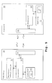
- Fig. 4 shows a schematic overview of a autonomous system with a memory 40 in which the digital map 10 is stored, a second memory 50, in which the searched places in a table or another digital card 15 are stored, a processor 60 and a user interface 70.
- the user gives over here User interface 70 criteria for a desired destination or intermediate destination, stored in the memory 50 digital map 15 or table is searched for a place that meets the criteria. This place is now the one you are looking for Place in the digital map 10, which is stored in memory 40 is.
- the location is according to the method of the invention discovered. He will then be through the user interface 70, over which the digital map 10 is displayed, in the digital map 10 marked, displayed and as a destination or Intermediate destination used for a route calculation.
- FIG. 5 shows a schematic overview of the system in FIG Vehicle 30 with the processor 60, the memory 50 with the digital card 10, the user interface 70 and one Communication device 80.
- About the Communication devices 80 and 85 communicate this Vehicle system with a system in a control center 90, the one Processor 65 and a memory 55, in which another digital card 15 is stored.
- About the Communication devices 80 and 85 are the criteria of User for a destination or interim destination to the central office 90 transferred, places and / or map elements are in the digital map 15 selected according to the criteria and and vehicle 30 transmitted. There the places and / or Map elements by means of the method locations and / or card elements found in the digital map 10 and further processed.
- FIG. 6 shows the structure of an object 100 shown Map element using the example of an edge.
- a place 102 of the Map element becomes the starting point of the edge taken.
- the southernmost or the westernmost point of the edge taken. at one-dimensional elements corresponds to the location of the Map element the place the object.
- the southernmost point of the object taken as a place Alternatively, it is also possible at multi-dimensional map elements as a place z. B. the lines or Area of focus.
- the height gives the height of the Edge above sea level (NN). Is that the Height information of an edge is not available Value z. B. be filled with the hex value "FFF" to make it clear that the altitude information is not for Available.
- the object class 104 denotes in present example a federal highway and the descriptive Information 106 identifies the present object in this Example as the Visualstrasse.
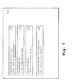
- an object searched in the digital map 110 is shown 105 shown in a transformed form.
- the transformed place 112 gives the distance to the reference point of the new one Coordinate system.
- the object, which defines the new coordinate system to be specified with In the example, this would be object 100 of FIG. 6, object 110 over the edge defined by the object 100 too to reach.
- the transformed location 112 thus indicates the distance the starting point 102 of the edge passing through object 100 is defined. From this point 102, the position of each Object on the edge 110 with a one-dimensional size - namely the distance 112 - be clearly described, regardless of the display type (traverse, splines ...) edges on the digital map 10. With distance 112 the position of the searched object 110 becomes unique described. As the starting point 102 of an edge can For example, the point of the edge taken by the has lower house numbers.
- the object class 116 allows hiding objects of other classes in the environment of the searched object, to reduce the number of objects in the final selection.
- the descriptive information 118 allows hiding other objects that belong to the same object class 116.
- the information road side 114 finally allows the Assignment of the object to a specific street side (for Building) or to a direction of travel (for traffic events), to come from the right side of a street, if z. B. the two directions by crash barriers or The like are separated from each other. This can be z. B. by a 1-bit value can be specified. "1" would then z. B. mean “from the starting point in the direction of travel and” 0 "would mean “from the starting point opposite to the direction of travel", d. H. across the street. Thus, too movable objects related to the associated roadside be clearly indicated.
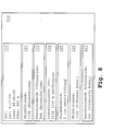
- the searched transformed object 120 is again represented with its reference coordinate system. This according to the schematic structure, the searched object of the headquarters are transmitted to the vehicle.
- the object with its reference system consists of the specification of the Location of the reference edge 121, with the object class of the reference edge 122, the descriptive information of the reference edge 123, the Reference to the reference edge location of the object 124, the statement street side 125, object class 126 and descriptive Information 127 of the object.
- a Search area generated, the center by the length and Width specification of the location 121 is given.
- Half the diagonal of the square search area is larger than the transformed place 124.
- the descriptive information 123 serves the corresponding Edge from the set of edges, the same object class belong to determine.
- the height is used at several Road sections with the same descriptive information 123 to distinguish between intersecting tracks.
- a route to this can Object 120 calculates or this object at the Route calculation are taken into account, z. B. at Traffic events.
- the searched object 120 is not present on the digital map 10, since the central-side digital map 15 is usually updated much more frequently than the vehicle-side digital map 10. If the searched object 120 is missing in the digital map 10, with the help of appropriate information, eg. B. version number, the digital card 10 centrally determined the difference of the digital map 10 to the digital map 15 and sent to the vehicle. For this purpose, the received difference is combined with the digital map 10 in the vehicle, so that the received map data together with the original digital map 10 result in a navigable map base. Conveniently, the information on the digital map 10 is sent to the center during the user's request for a searched object as a destination or intermediate destination along with the request or in a separate block.
- appropriate information eg. B. version number
- step b1 the schematic representation in FIG. 1 of the method . If this is the case, ie the object 100 is also contained in the digital map 10, only the object information of the object 120 is transmitted to the vehicle. Otherwise, that is, if the edge 100 is not included in the map 10, the center 90 creates a corresponding map section with the required / necessary detailing and sends this information to the vehicle 30 - this is done in step c2) of the schematic representation in Fig. 1 of process. The central unit 90 then sends the object information 120.
- the received map data is merged with the existing map base 10, so that a navigable map base is created in the vehicle 30.
- the map section can be z.
- "real" map information can also be transmitted in the form of detailed map information.
- object Klas Description level 1 Description level 2 Description level 3 Description level 4 se 1000 Roads & Ferries 1100 Street elements t 1110 European Route (E) 1120 Highway (A) 1130 Federal highway (B) 1140 Street 1141 Country road (L) 1142 County Road (K) 1143 connection 1144 residential street 1145 Private 1146 sidewalk 1147 driveway 1200 Ferries ... 3000 traffic incidents 3100 accidents 3110 Rear-end collisions 3111 ... 3120 Accidents on the roadside 3200 traffic congestion 3300 construction sites ...
- To determine the distance of the object 110 from the reference point of the object 100 may be the difference of the two geo coordinates the locations of object 110 and object 100 with the aid of digital card 15 are formed.
- the invention also makes that possible Finding objects that are three-dimensional - eg. B. intersecting entrances / exits of motorway junctions leading to the same edge or the same section of motorway.
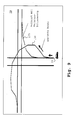
- Fig. 9 shows the map representation of a motorway intersection as such an example.
- the two driveways 130 and 135 have the same descriptive information. If the traffic is now jammed on one of the two ramps, it can not be determined in the vehicle 30 on which of the two ramps the obstacle is present.
- Another example is when with two intersecting streets with similar names, z. B. Ulmer Straße, Ulmer Allee, an object to be found at the crossroads. Here, no distinction between the two objects is possible without height information.
- the method allows locating these objects in the map 10 and thus allows the objects to be further processed as targets or intermediate destinations for onboard navigation. This optimizes the interaction between the onboard navigation system and the central station 90.
- Dynamic objects are objects that are locally bound, such as As city festivals that represent localized traffic disruptions, z. B. Accident, construction site, and the slowly moving objects represent how. z. B. traffic congestion.
- the position information for traffic disruption of any kind is very blurred today, the blur is but with today's allocation procedures, eg. B. TMC, still increased.
- the method according to the invention takes into account that the position information for traffic disruptions will become more accurate in the future, and that the exact position can then be transmitted from the center 90 to the vehicle 30 with the present method.
- one and the same object class catalog contains all objects of a digital map 10 or 15. It makes no difference whether an object is a searched object or a navigation-relevant object. This saves twice the effort of creating two separate object class catalogs.
- an optimized behavior of the processors 60 and 65 is achieved.
- Another advantage of the system is that with the searched object 110 equal to the edge 100, via which the searched object can be approached, is also transmitted, so that the interaction with the navigation is further improved.
- the use in the navigation system is possible without elaborate preparation, so that there is the possibility of optimal route guidance to the object.
- a searched Object is located on an edge in the digital Map 10 is not available.
- the navigation system takes the edge on the itself the object is located in the digital map 10.
- the object must but not necessarily in the digital map 10 right edge. It may also happen that Object 140 is between two edges 170 and 180. Of the Access 160 to the object 140 is in the example of Fig. 10 on the Edge 180 possible. Because the navigation system, the edge over the the access to the object 140 is possible, not transferred was, it may happen that the navigation system to the object 140 assigns access 150 via edge 170. In reality this access is not possible.
- the inventive method provides a remedy by together with the searched object 140 the edge over which the object can be achieved, is transmitted. In the present Example would then be the object 140, the edge 180 mitauertragen and thus calculates the route over the edge 180.
Landscapes
- Engineering & Computer Science (AREA)
- Physics & Mathematics (AREA)
- Radar, Positioning & Navigation (AREA)
- Remote Sensing (AREA)
- General Physics & Mathematics (AREA)
- Theoretical Computer Science (AREA)
- Automation & Control Theory (AREA)
- Databases & Information Systems (AREA)
- Mathematical Physics (AREA)
- Business, Economics & Management (AREA)
- Educational Administration (AREA)
- Educational Technology (AREA)
- Navigation (AREA)
- Traffic Control Systems (AREA)
- Instructional Devices (AREA)
Abstract
Description
- Fig. 1
- ein Ablaufdiagramm des Verfahrens,
- Fig. 2
- eine digitale Karte mit Knoten und Kanten,
- Fig. 3
- eine digitale Karte mit Knoten und Kanten und dem aufgefundenen Ort,
- Fig. 4
- einen Überblick über ein fahrzeugautonomes System,
- Fig. 5
- einen Überblick über ein System mit Zentrale,
- Fig. 6
- Aufbau eines als Objekt dargestellten Kartenelementes, am Beispiel einer als Bezugssystem dienenden Kante,
- Fig. 7
- ein gesuchtes Objekt in transformierter Form,
- Fig. 8
- Aufbau eines gesuchten Objektes mit Bezugssystem,
- Fig. 9
- die Kartendarstellung eines Autobahnkreuzes und
- Fig. 10
- ein Objekt mit einem Zugang über eine Kante.
Manöverpunkten/Manöverhinweisen bestehen, deren Startpunkt auf der im Fahrzeug 30 vorhandenen Kartendatenbank 10 enthalten sein muss, um die empfangenen und die vorhandenen Kartendaten zusammenzuführen. Es können aber auch "echte" Karteninformationen in Form von detaillierten Karteninformationen übertragen werden.
| Objektklas | Beschreibungsebene 1 | Beschreibungsebene 2 | Beschreibungsebene 3 | Beschreibungsebene 4 |
| se | ||||
| 1000 | Straßen & Fähren | |||
| 1100 | Straßenelement | |||
| 1110 | Europastraße (E) | |||
| 1120 | Autobahn (A) | |||
| 1130 | Bundesstraße (B) | |||
| 1140 | Straße | |||
| 1141 | Landstraße (L) | |||
| 1142 | Kreisstraße (K) | |||
| 1143 | Verbindung | |||
| 1144 | Wohnstraße | |||
| 1145 | Privat | |||
| 1146 | Fußgängerweg | |||
| 1147 | Zufahrt | |||
| 1200 | Fähren | |||
| ... | ||||
| 3000 | Verkehrsereignisse | |||
| 3100 | Unfälle | |||
| 3110 | Auffahrunfälle | |||
| 3111 | ... | |||
| 3120 | Unfälle am Straßenrand | |||
| 3200 | Verkehrsstaus | |||
| 3300 | Baustellen | |||
| ... | ||||
| 4000 | Verkehrsereignisse | |||
| 5000 | Polizei / | |||
| Feuerwehr / Ärzte / Krankenhäuser | ||||
| 6000 | Sehenswürdigkeiten | |||
| 7000 | Hotels / Restaurants / Bars | |||
| 8000 | Banken / Geschäfte | |||
| 7100 | Hotels & Pensionen | |||
| 7110 | Pensionen | |||
| 7111 | ... | |||
| 7120 | 1* Hotels | |||
| 7130 | 2* Hotels | |||
| 7160 | 5* Hotels | |||
| 7170 | Appartements | |||
| 7200 | Restaurants | |||
| 7300 | Bars | |||
| ... | ||||
| 8000 | Sonstige Veranstaltungen | |||
| ... |
Unter dynamischen Objekten werden Objekte verstanden, die örtlich gebunden sind, wie z. B. Stadtfestivals, die örtlich gebundene Verkehrsstörungen darstellen, z. B. Unfall, Baustelle, und die langsam bewegliche Objekte darstellen, wie. z. B. Verkehrsstaus. Die Positionsangabe für Verkehrsstörungen jeglicher Art ist heute sehr unscharf, die Unschärfe wird aber mit heutigen Zuordnungsverfahren, z. B. TMC, noch erhöht. Das erfindungsgemäße Verfahren berücksichtigt, dass die Positionsangabe für Verkehrsstörungen in Zukunft genauer werden wird, und dass dann mit dem vorliegenden Verfahren auch die genaue Position von der Zentrale 90 ans Fahrzeug 30 übermittelt werden kann. Vorteilhaft ist weiter, dass ein und derselbe Objektklassenkatalog alle Objekte einer digitalen Karte 10 oder 15 enthält. Es wird kein Unterschied gemacht, ob es sich bei einem Objekt um ein gesuchtes Objekt oder um ein navigationsrelevantes Objekt handelt. Dies erspart den doppelten Aufwand, um zwei getrennte Objektklassenkataloge zu erstellen. Außerdem wird ein optimiertes Verhalten der Prozessoren 60 und 65 erreicht. Ein weiterer Vorteil des Systems besteht darin, dass mit dem gesuchten Objekt 110 gleich die Kante 100, über die das gesuchte Objekt angefahren werden kann, mit übertragen wird, so dass das Zusammenspiel mit der Navigation weiter verbessert wird. Die Verwendung im Navigationssystem ist ohne aufwendige Aufbereitung möglich, so dass sich die Möglichkeit einer optimalen Zielführung zum Objekt ergibt.
Claims (21)
- Verfahren zum Auffinden eines Ortes (20, 112, 124) in einer digitalen Karte (10), deren Orte bezogen auf ein erstes Koordinatensystem angegeben sind, mit den folgenden Schritten:a) Bestimmung eines zweiten Koordinatensystems, das bezogen auf das erste Koordinatensystem angegeben ist,b) Bestimmung der Koordinatendaten des gesuchten Ortes (20, 112, 124) bezogen auf das zweite Koordinatensystem,c) Auffinden des zweiten Koordinatensystems in der digitalen Karte (10),d) Auffinden des gesuchten Ortes (20, 112, 124) in der digitalen Karte (10) durch Auftragen der Koordinatendaten des gesuchten Ortes (20, 112, 124) im zweiten Koordinatensystem.
- Verfahren nach Anspruch 1,
dadurch gekennzeichnet, dass die bestimmenden Daten des zweiten Koordinatensystems einen Bezugspunkt (14, 102) und weitere Informationen (104, 106) umfassen. - Verfahren nach Anspruch 1 oder 2,
dadurch gekennzeichnet, dass Kartenelemente (12, 100, 110, 120, 130, 135, 140, 150, 160, 170, 180) Orte (102, 20, 112, 124) und zusätzliche Informationen (104, 106, 114, 116, 118, 122, 123, 125, 126, 127) umfassen. - Verfahren nach Anspruch 3,
dadurch gekennzeichnet, dass das zweite Koordinatensystem durch ein Kartenelement (100) in der digitalen Karte (10) definiert ist, wobei der Bezugspunkt (102) des zweiten Koordinatensystems dem Ort (102) des Kartenelements (100) entspricht. - Verfahren nach einem der vorhergehenden Ansprüche,
dadurch gekennzeichnet, dass die gesuchten Orte (20, 112, 124) in einer Tabelle und/oder einer weiteren digitalen Karte (15) gespeichert sind. - Verfahren nach Anspruch 5,
dadurch gekennzeichnet, dass nach Schritt b) und vor Schritt c)
im Schritt b1) überprüft wird, ob das das zweite Koordinatensystems definierende Kartenelement (100) in der digitalen Karte (10) vorhanden ist,
und falls es fehlt, im Schritt b2) das das zweite Koordinatensystems definierende Kartenelement (100) von der weiteren digitalen Karte (15) in die digitale Karte (10) übertragen und dort gespeichert wird. - Verfahren nach einem der vorhergehenden Ansprüche,
dadurch gekennzeichnet, dass
der Schritt c) zum Auffinden des das zweite Koordinatensystem definierenden Kartenelementes (100) sich in die folgenden Teilschritte untergliedert: der Ort (102) des Kartenelementes wird aufgefunden, dann wird geprüft, ob sich Kartenelemente am Ort oder in der Nähe des Ortes des Kartenelementes (102) befinden, und dann werden ausgewählte zusätzliche Informationen des Kartenelementes (100) mit zusätzlichen Informationen von Kartenelementen verglichen, die sich in der digitalen Karte am Ort oder in der Nähe des Ortes des Kartenelementes (102) befinden. - Verfahren nach einem der vorhergehenden Ansprüche,
dadurch gekennzeichnet, dass auch ein Kartenelement (110, 120, 140) aufgefunden werden kann, indem der Ort des Kartenelementes (112, 124) gemäß zumindest der Schritt a), b), c) und d) aufgefunden wird, dann geprüft wird, ob sich Kartenelemente am Ort oder in der Nähe des Ortes des Kartenelementes (110, 120, 140) befinden,
und dann ausgewählte zusätzliche Informationen des Kartenelementes (110, 120, 140) mit zusätzlichen Informationen von Kartenelementen verglichen werden, die sich in der digitalen Karte am Ort oder in der Nähe des Ortes des Kartenelementes (112, 124) befinden. - Verfahren nach Anspruch 8,
dadurch gekennzeichnet, dass falls festgestellt wird, dass das gesuchte Kartenelement (110, 120, 140) in der digitalen Karte (10) fehlt,
es in einem weiteren Schritt von der Tabelle und/oder von der weiteren digitalen Karte (15) in die digitale Karte (10) übertragen und dort gespeichert wird. - Verfahren nach einem der vorhergehenden Ansprüche, dadurch gekennzeichnet, dass der gesuchte Ort (20, 112, 124) bzw. das gesuchte Kartenelement (110, 120, 140) als Ziel oder Zwischenziel für eine Routenberechnung dient.
- Verfahren nach einem der vorhergehenden Ansprüche, dadurch gekennzeichnet, dass das zweite Koordinatensystem eindimensional ist.
- Verfahren nach Anspruch 11,
dadurch gekennzeichnet, dass das das weitere Koordinatensystem definierende Kartenelement (100) eine Kante ist. - Verfahren nach Anspruch 12,
dadurch gekennzeichnet, dass die Kante auf einer berechneten Route für ein Fahrzeug (30) liegt. - Verfahren nach Anspruch 12 oder 13,
dadurch gekennzeichnet, dass der gesuchte Ort (20, 112, 124) bzw. das gesuchte Kartenelement (110, 120, 140) über die Kante erreicht werden kann. - Verfahren nach einem der vorhergehenden Ansprüche,
dadurch gekennzeichnet, dass zum Auffinden des gesuchten (110, 120, 140) Kartenelementes auf der digitalen Karte (10) ein Suchgebiet generiert wird. - Verfahren nach einem der Ansprüche 3 bis 15,
dadurch gekennzeichnet, dass die Kartenelemente als Objekte (100, 110, 120) angegeben sind, wobei die weiteren Informationen (104, 106, 114, 116, 118, 122, 123, 125, 126, 127) der Kartenelemente den Attributen der Objekte (104, 106, 114, 116, 118, 122, 123, 125, 126, 127) entsprechen. - Verfahren nach Anspruch 16,
dadurch gekennzeichnet, dass Attribute der Objekte (104, 106, 114, 116, 118, 122, 123, 125, 126, 127) dazu verwendet werden, das gesuchte Objekt (110, 120) unter den Objekten der gleichen Klasse (104, 116, 122, 126) im Suchgebiet zu ermitteln. - System mit einem ersten Speicher (40) zur Speicherung der digitalen Karte (10), einem zweiten Speicher (50, 55) zur Speicherung der weiteren digitalen Karte (15) und/oder der Tabelle, mindestens einem Prozessor (60) zum Durchführen des Verfahrens nach einem der vorhergehenden Ansprüche oder nach Merkmalen mindestens eines der vorhergehenden Ansprüche, und einer optischen und/oder akustischen Benutzerschnittstelle (70), wobei zumindest der erste Speicher (40), der mindestens eine Prozessor (60) und die optische und/oder akustische Benutzerschnittstelle (70) in einem Fahrzeug (30) angeordnet sind.
- System nach Anspruch 18,
dadurch gekennzeichnet, dass im Fahrzeug Kommunikationseinrichtungen (80) vorhanden sind. - System nach Anspruch 18 oder 19,
dadurch gekennzeichnet, dass der zweite Speicher im Fahrzeug (50) und/oder in einer Zentrale (55) angeordnet ist. - System nach Anspruch 20,
dadurch gekennzeichnet, dass im Fahrzeug (30) und/oder in der Zentrale (90) eine Routenberechnung erfolgt und Manöverhinweise über die optische und/oder akustische Benutzerschnittstelle (70) ausgegeben werden.
Applications Claiming Priority (2)
| Application Number | Priority Date | Filing Date | Title |
|---|---|---|---|
| DE10137632 | 2001-08-03 | ||
| DE10137632A DE10137632A1 (de) | 2001-08-03 | 2001-08-03 | Verfahren und System zum Auffinden eines Ortes in einer digitalen Karte |
Publications (2)
| Publication Number | Publication Date |
|---|---|
| EP1281933A1 true EP1281933A1 (de) | 2003-02-05 |
| EP1281933B1 EP1281933B1 (de) | 2005-10-05 |
Family
ID=7693956
Family Applications (1)
| Application Number | Title | Priority Date | Filing Date |
|---|---|---|---|
| EP02016544A Expired - Lifetime EP1281933B1 (de) | 2001-08-03 | 2002-07-24 | Verfahren und System zum Auffinden eines Ortes in einer digitalen Karte |
Country Status (4)
| Country | Link |
|---|---|
| US (1) | US6847886B2 (de) |
| EP (1) | EP1281933B1 (de) |
| DE (2) | DE10137632A1 (de) |
| ES (1) | ES2249517T3 (de) |
Families Citing this family (16)
| Publication number | Priority date | Publication date | Assignee | Title |
|---|---|---|---|---|
| US5839088A (en) * | 1996-08-22 | 1998-11-17 | Go2 Software, Inc. | Geographic location referencing system and method |
| JP4080785B2 (ja) * | 2002-04-30 | 2008-04-23 | パイオニア株式会社 | 情報提供装置及び情報提供方法 |
| DE102007013561A1 (de) * | 2007-03-21 | 2008-09-25 | Continental Automotive Gmbh | Verfahren und Vorrichtung zum Betreiben eines Navigationssystems |
| US9179292B2 (en) | 2007-08-27 | 2015-11-03 | Microsoft Technology Licensing, Llc | Creation and management of RFID device versions |
| US20100145963A1 (en) * | 2008-12-04 | 2010-06-10 | Morris Robert P | Methods, Systems, And Computer Program Products For Resolving A Network Identifier Based On A Geospatial Domain Space Harmonized With A Non-Geospatial Domain Space |
| US20100146132A1 (en) * | 2008-12-04 | 2010-06-10 | Morris Robert P | Methods, Systems, And Computer Program Products For Accessing A Resource Having A Network Address Associated With A Location On A Map |
| US20100146114A1 (en) * | 2008-12-04 | 2010-06-10 | Morris Robert P | Methods, Systems, And Computer Program Products For Accessing A Resource Based On Metadata Associated With A Location On A Map |
| US20100162124A1 (en) * | 2008-12-19 | 2010-06-24 | Morris Robert P | Methods, Systems, And Computer Program Products For Presenting A Map In Correspondence With A Presented Resource |
| US20100161732A1 (en) * | 2008-12-19 | 2010-06-24 | Morris Robert P | Methods, Systems, And Computer Program Products For Maintaining Consistency Between Non-Geospatial And Geospatial Network Directory Systems |
| US8724834B2 (en) * | 2010-01-06 | 2014-05-13 | Honeywell International Inc. | Acoustic user interface system and method for providing spatial location data |
| EP2556339B8 (de) * | 2010-04-09 | 2018-12-26 | TomTom Navigation B.V. | Verfahren und vorrichtung zur erzeugung einer kostenfunktion |
| US9581994B2 (en) | 2011-04-05 | 2017-02-28 | Fisher-Rosemount Systems, Inc. | Methods and apparatus to manage process control resources |
| US11481091B2 (en) * | 2013-05-15 | 2022-10-25 | Google Llc | Method and apparatus for supporting user interactions with non- designated locations on a digital map |
| CN106323303A (zh) * | 2016-09-29 | 2017-01-11 | 汤晓庆 | 一种在地图中沿道路标记位置的系统及其方法 |
| JP7627816B2 (ja) * | 2020-11-20 | 2025-02-07 | 深▲ジェン▼引望智能技術有限公司 | I/oデバイス・アクセス方法及び装置 |
| CN112632208B (zh) * | 2020-12-25 | 2022-12-16 | 际络科技(上海)有限公司 | 一种交通流轨迹变形方法及装置 |
Citations (5)
| Publication number | Priority date | Publication date | Assignee | Title |
|---|---|---|---|---|
| DE19539367A1 (de) * | 1995-10-23 | 1997-04-24 | Siemens Ag | Verfahren zum Transformieren eines Koordinatensystems |
| EP0798540A1 (de) * | 1996-03-25 | 1997-10-01 | MANNESMANN Aktiengesellschaft | Verfahren zur Referenzierung von ortsfesten Objekten |
| DE19750786A1 (de) * | 1996-11-28 | 1998-06-04 | Mannesmann Ag | Verfahren und Endgerät zur räumlichen Zuordnung von auf einen Ort bezogenen Informationen |
| DE19911676A1 (de) * | 1998-12-14 | 2000-06-29 | Mannesmann Ag | Duales Übertragungssystem |
| EP1028405A2 (de) * | 1999-02-10 | 2000-08-16 | Robert Bosch Gmbh | Verfahren zur Übertragung von auf Orte bezogenen Informationen |
Family Cites Families (15)
| Publication number | Priority date | Publication date | Assignee | Title |
|---|---|---|---|---|
| DE4028214C2 (de) * | 1990-09-06 | 1996-05-30 | Nuclear Cargo & Service Gmbh | Verfahren zur Umsetzung von in Werten eines geographischen Koordinatensystems erzeugten Standortdaten in eine auf einem karthesischen Koordinatensystem beruhende Rasterform |
| JP3275190B2 (ja) * | 1993-11-19 | 2002-04-15 | 本田技研工業株式会社 | 地図情報再生装置 |
| US5802492A (en) * | 1994-06-24 | 1998-09-01 | Delorme Publishing Company, Inc. | Computer aided routing and positioning system |
| DE69526825T2 (de) * | 1994-09-08 | 2002-11-07 | Matsushita Electric Industrial Co., Ltd. | Verfahren und System zur Routenauswahl |
| US5839088A (en) * | 1996-08-22 | 1998-11-17 | Go2 Software, Inc. | Geographic location referencing system and method |
| JP3375258B2 (ja) * | 1996-11-07 | 2003-02-10 | 株式会社日立製作所 | 地図表示方法及び装置並びにその装置を備えたナビゲーション装置 |
| US5978733A (en) * | 1996-12-09 | 1999-11-02 | Xanavi Informatics Corporation | Route search apparatus |
| JP3798489B2 (ja) * | 1997-01-14 | 2006-07-19 | 株式会社ザナヴィ・インフォマティクス | 車載用ナビゲーション装置 |
| EP1531319A3 (de) * | 1997-01-29 | 2006-05-03 | Matsushita Electric Industrial Co., Ltd. | Routensuchverfahren und -vorrichtung |
| JP3500928B2 (ja) * | 1997-09-17 | 2004-02-23 | トヨタ自動車株式会社 | 地図データ処理装置、地図データ処理方法および地図データ処理システム |
| JP3771044B2 (ja) * | 1998-04-20 | 2006-04-26 | アイシン・エィ・ダブリュ株式会社 | ナビゲーション装置 |
| EP1020832A1 (de) * | 1998-04-28 | 2000-07-19 | Robert Bosch Gmbh | Verfahren zur Generierung von Positionsreferenz für eine digitale Karte |
| DE19829538A1 (de) * | 1998-07-02 | 2000-01-05 | Bosch Gmbh Robert | Verfahren zur Beeinflussung von Quelldaten zur Bestimmung einer Route bei einem Navigationssystem |
| DE19928295A1 (de) * | 1999-06-22 | 2000-12-28 | Bosch Gmbh Robert | Verfahren und Vorrichtung zum Bestimmen einer Route von einem Ausgangsort zu einem Zielort |
| DE10009149A1 (de) * | 1999-09-07 | 2001-03-08 | Bosch Gmbh Robert | Verfahren zur Codierung und Decodierung von Objekten in einem Verkehrswegenetz |
-
2001
- 2001-08-03 DE DE10137632A patent/DE10137632A1/de not_active Withdrawn
-
2002
- 2002-07-24 ES ES02016544T patent/ES2249517T3/es not_active Expired - Lifetime
- 2002-07-24 DE DE50204445T patent/DE50204445D1/de not_active Expired - Lifetime
- 2002-07-24 EP EP02016544A patent/EP1281933B1/de not_active Expired - Lifetime
- 2002-08-02 US US10/209,976 patent/US6847886B2/en not_active Expired - Lifetime
Patent Citations (5)
| Publication number | Priority date | Publication date | Assignee | Title |
|---|---|---|---|---|
| DE19539367A1 (de) * | 1995-10-23 | 1997-04-24 | Siemens Ag | Verfahren zum Transformieren eines Koordinatensystems |
| EP0798540A1 (de) * | 1996-03-25 | 1997-10-01 | MANNESMANN Aktiengesellschaft | Verfahren zur Referenzierung von ortsfesten Objekten |
| DE19750786A1 (de) * | 1996-11-28 | 1998-06-04 | Mannesmann Ag | Verfahren und Endgerät zur räumlichen Zuordnung von auf einen Ort bezogenen Informationen |
| DE19911676A1 (de) * | 1998-12-14 | 2000-06-29 | Mannesmann Ag | Duales Übertragungssystem |
| EP1028405A2 (de) * | 1999-02-10 | 2000-08-16 | Robert Bosch Gmbh | Verfahren zur Übertragung von auf Orte bezogenen Informationen |
Also Published As
| Publication number | Publication date |
|---|---|
| DE10137632A1 (de) | 2003-02-27 |
| ES2249517T3 (es) | 2006-04-01 |
| DE50204445D1 (de) | 2006-02-16 |
| US6847886B2 (en) | 2005-01-25 |
| EP1281933B1 (de) | 2005-10-05 |
| US20030083811A1 (en) | 2003-05-01 |
Similar Documents
| Publication | Publication Date | Title |
|---|---|---|
| DE3854785T2 (de) | Navigationssystem | |
| EP1281933B1 (de) | Verfahren und System zum Auffinden eines Ortes in einer digitalen Karte | |
| EP0798540B1 (de) | Verfahren zur Referenzierung von ortsfesten Objekten | |
| DE69828339T2 (de) | Programm zum Erzeugen von Manövern | |
| DE69835055T2 (de) | Verfahren und Vorrichtung zur Anzeige der momentanen Position eines Fahrzeugs | |
| EP1030166B1 (de) | Verfahren zur Navigation eines Objekts | |
| DE69819337T2 (de) | Fahrzeuginformationssystem | |
| DE69732015T2 (de) | Karthographisches Datenbankgerät | |
| DE60019951T2 (de) | Echtzeitverteilte navigationsverfahren | |
| EP1198696B1 (de) | Verfahren und vorrichtung zur übermittlung von navigations-informationen von einer datenzentrale an ein fahrzeug-basiertes navigationssystem | |
| DE69719694T2 (de) | Wegsuchgerät | |
| EP1224645B2 (de) | Verfahren zur codierung und decodierung von objekten in einem verkehrswegenetz | |
| EP0941533B1 (de) | Verfahren und endgerät zur räumlichen zuordnung von auf einen ort bezogenen informationen | |
| EP1159585B1 (de) | Verfahren zum betrieb eines navigationssystems | |
| DE19651146A1 (de) | Verfahren und Anordnung zur Information mobiler Teilnehmer | |
| DE69617172T2 (de) | System zum verbinden von elementen mit komplizierten kreuzungen und einmündungen in einer strassennetzdarstellung für fahrzeuge | |
| DE102020105313A1 (de) | Verfahren, Recheneinrichtung und System zum Kartographieren von Landmarken eines Straßennetzes in einer Straßenkarte | |
| DE102018218436A1 (de) | Fahrzeugparkassistenz | |
| EP1062481B1 (de) | Verfahren zur ausgabe von verkehrsinformationen | |
| DE112004001740T5 (de) | Fahrzeuginternes Informationsendgerät, Routeneigenschaften-Gewinnungsvorrichtung und Routeneigenschaften-Anzeigeverfahren | |
| DE102019103671A1 (de) | Steuerung eines Kraftfahrzeugs | |
| EP1245017B1 (de) | Verfahren zum beschreiben und erzeugen von strassennetzen und strassennetz | |
| DE69326114T2 (de) | Verfahren und Vorrichtung zur Fahrzeugführung auf Verkehrsstrassen | |
| DE19750786C2 (de) | Verfahren und Endgerät zur räumlichen Zuordnung von auf einen Ort bezogenen Informationen | |
| DE10128517A1 (de) | Verfahren zum Erzeugen von Navigationsdaten für eine Routenführung sowie Navigationssystem |
Legal Events
| Date | Code | Title | Description |
|---|---|---|---|
| PUAI | Public reference made under article 153(3) epc to a published international application that has entered the european phase |
Free format text: ORIGINAL CODE: 0009012 |
|
| 17P | Request for examination filed |
Effective date: 20021115 |
|
| AK | Designated contracting states |
Designated state(s): AT BE BG CH CY CZ DE DK EE ES FI FR GB GR IE IT LI LU MC NL PT SE SK TR |
|
| AX | Request for extension of the european patent |
Extension state: AL LT LV MK RO SI |
|
| AKX | Designation fees paid |
Designated state(s): DE ES FR GB IT NL |
|
| 17Q | First examination report despatched |
Effective date: 20041014 |
|
| GRAP | Despatch of communication of intention to grant a patent |
Free format text: ORIGINAL CODE: EPIDOSNIGR1 |
|
| RIC1 | Information provided on ipc code assigned before grant |
Ipc: 7G 01C 21/32 A Ipc: 7G 09B 29/10 B Ipc: 7G 01C 21/30 B |
|
| GRAS | Grant fee paid |
Free format text: ORIGINAL CODE: EPIDOSNIGR3 |
|
| GRAA | (expected) grant |
Free format text: ORIGINAL CODE: 0009210 |
|
| AK | Designated contracting states |
Kind code of ref document: B1 Designated state(s): DE ES FR GB IT NL |
|
| REG | Reference to a national code |
Ref country code: GB Ref legal event code: FG4D Free format text: NOT ENGLISH |
|
| GBT | Gb: translation of ep patent filed (gb section 77(6)(a)/1977) |
Effective date: 20060119 |
|
| REF | Corresponds to: |
Ref document number: 50204445 Country of ref document: DE Date of ref document: 20060216 Kind code of ref document: P |
|
| REG | Reference to a national code |
Ref country code: ES Ref legal event code: FG2A Ref document number: 2249517 Country of ref document: ES Kind code of ref document: T3 |
|
| ET | Fr: translation filed | ||
| PLBE | No opposition filed within time limit |
Free format text: ORIGINAL CODE: 0009261 |
|
| STAA | Information on the status of an ep patent application or granted ep patent |
Free format text: STATUS: NO OPPOSITION FILED WITHIN TIME LIMIT |
|
| 26N | No opposition filed |
Effective date: 20060706 |
|
| NLT1 | Nl: modifications of names registered in virtue of documents presented to the patent office pursuant to art. 16 a, paragraph 1 |
Owner name: DAIMLER AG |
|
| PGFP | Annual fee paid to national office [announced via postgrant information from national office to epo] |
Ref country code: ES Payment date: 20080729 Year of fee payment: 7 |
|
| PGFP | Annual fee paid to national office [announced via postgrant information from national office to epo] |
Ref country code: IT Payment date: 20080723 Year of fee payment: 7 Ref country code: NL Payment date: 20080716 Year of fee payment: 7 |
|
| REG | Reference to a national code |
Ref country code: FR Ref legal event code: CD Ref country code: FR Ref legal event code: CA |
|
| NLV4 | Nl: lapsed or anulled due to non-payment of the annual fee |
Effective date: 20100201 |
|
| REG | Reference to a national code |
Ref country code: FR Ref legal event code: TP |
|
| REG | Reference to a national code |
Ref country code: ES Ref legal event code: FD2A Effective date: 20090725 |
|
| PG25 | Lapsed in a contracting state [announced via postgrant information from national office to epo] |
Ref country code: ES Free format text: LAPSE BECAUSE OF NON-PAYMENT OF DUE FEES Effective date: 20090725 |
|
| PG25 | Lapsed in a contracting state [announced via postgrant information from national office to epo] |
Ref country code: IT Free format text: LAPSE BECAUSE OF NON-PAYMENT OF DUE FEES Effective date: 20090724 |
|
| PG25 | Lapsed in a contracting state [announced via postgrant information from national office to epo] |
Ref country code: NL Free format text: LAPSE BECAUSE OF NON-PAYMENT OF DUE FEES Effective date: 20100201 |
|
| PGFP | Annual fee paid to national office [announced via postgrant information from national office to epo] |
Ref country code: DE Payment date: 20120731 Year of fee payment: 11 |
|
| PGFP | Annual fee paid to national office [announced via postgrant information from national office to epo] |
Ref country code: GB Payment date: 20130624 Year of fee payment: 12 |
|
| PGFP | Annual fee paid to national office [announced via postgrant information from national office to epo] |
Ref country code: FR Payment date: 20130712 Year of fee payment: 12 |
|
| PG25 | Lapsed in a contracting state [announced via postgrant information from national office to epo] |
Ref country code: DE Free format text: LAPSE BECAUSE OF NON-PAYMENT OF DUE FEES Effective date: 20140201 |
|
| REG | Reference to a national code |
Ref country code: DE Ref legal event code: R119 Ref document number: 50204445 Country of ref document: DE Effective date: 20140201 |
|
| GBPC | Gb: european patent ceased through non-payment of renewal fee |
Effective date: 20140724 |
|
| REG | Reference to a national code |
Ref country code: FR Ref legal event code: ST Effective date: 20150331 |
|
| PG25 | Lapsed in a contracting state [announced via postgrant information from national office to epo] |
Ref country code: FR Free format text: LAPSE BECAUSE OF NON-PAYMENT OF DUE FEES Effective date: 20140731 Ref country code: GB Free format text: LAPSE BECAUSE OF NON-PAYMENT OF DUE FEES Effective date: 20140724 |