EP1146315A2 - Lane guidance display method, and navigation device and recording medium for realizing the method - Google Patents
Lane guidance display method, and navigation device and recording medium for realizing the method Download PDFInfo
- Publication number
- EP1146315A2 EP1146315A2 EP01102854A EP01102854A EP1146315A2 EP 1146315 A2 EP1146315 A2 EP 1146315A2 EP 01102854 A EP01102854 A EP 01102854A EP 01102854 A EP01102854 A EP 01102854A EP 1146315 A2 EP1146315 A2 EP 1146315A2
- Authority
- EP
- European Patent Office
- Prior art keywords
- lane
- guidance
- intersection
- recommended
- target
- Prior art date
- Legal status (The legal status is an assumption and is not a legal conclusion. Google has not performed a legal analysis and makes no representation as to the accuracy of the status listed.)
- Withdrawn
Links
Images


Classifications
-
- G—PHYSICS
- G01—MEASURING; TESTING
- G01C—MEASURING DISTANCES, LEVELS OR BEARINGS; SURVEYING; NAVIGATION; GYROSCOPIC INSTRUMENTS; PHOTOGRAMMETRY OR VIDEOGRAMMETRY
- G01C21/00—Navigation; Navigational instruments not provided for in groups G01C1/00 - G01C19/00
- G01C21/26—Navigation; Navigational instruments not provided for in groups G01C1/00 - G01C19/00 specially adapted for navigation in a road network
- G01C21/34—Route searching; Route guidance
- G01C21/36—Input/output arrangements for on-board computers
- G01C21/3626—Details of the output of route guidance instructions
- G01C21/3658—Lane guidance
-
- G—PHYSICS
- G08—SIGNALLING
- G08G—TRAFFIC CONTROL SYSTEMS
- G08G1/00—Traffic control systems for road vehicles
- G08G1/09—Arrangements for giving variable traffic instructions
- G08G1/0962—Arrangements for giving variable traffic instructions having an indicator mounted inside the vehicle, e.g. giving voice messages
- G08G1/0968—Systems involving transmission of navigation instructions to the vehicle
- G08G1/0969—Systems involving transmission of navigation instructions to the vehicle having a display in the form of a map
Definitions
- the present invention relates to a lane guidance display method, and a navigation device and a recording medium for realizing the method. More specifically, the lane guidance display method is employed by the navigation device mounted in a vehicle, for example, and used to guide the vehicle on a display which lane to take to enter an intersection or exit therefrom.
- the recording medium contains a program for executing this method.
- navigation devices which are of a type mounted in a vehicle, for example, to guide a vehicle from a departure point to a destination or a stopover.
- Displayed by such conventional navigation device is a map covering a driving route with heading direction by voice, optionally, when needed. For example, before an intersection at where the vehicle is supposed to turn left, the driver hears such voice as "please take a left turn at the next intersection".
- the driver may need to follow lane control when turning right or left, or going straight. If this is the case, such guidance as "take a left turn at the next intersection" is not helpful enough for the driver to decide which lane to take.
- the driver has to look for traffic signs and road markings, for example, for information relating such lane control.
- the problem herein is, if the driver is unfamiliar with the road, he/she may often find it difficult to decide which lane to take until the last minute. The reason lies in the fact that such information relating lane control (traffic signs, and the like) is often presented in the very close vicinity of the intersection. Therefore, when the driver is unfamiliar with the road, such conventional route guidance does not provide him/her with much assistance, and consequently results in sudden lane change or failure in lane change, preventing the driver from keeping track of the searched route.
- Japanese Patent Laid-Open Publication No. 2000-18956 discloses such vehicle-mounted navigation device, providing a lane guidance by voice for every intersection on a driving route between a departure point and a destination or a stopover in consideration of heading direction. For example, when the vehicle is supposed to turn left at the next intersection, the driver hears a voice saying "please move into a far left lane, and keep going" before hearing "please take a left turn at the next intersection".
- the driver is unskilled in driving or unfamiliar with the area, he/she may also want to know on which lane he/she is supposed to be when exiting the intersection. That is, in a case where the vehicle needs to make turns in a row, for example first left and then right, in a short distance on the roads with several lanes, the most preferred is taking a far right lane after turning left.
- lane guidance is offered by voice as appropriate together with the map of running route on the display.
- the issue here is, the driver needs to correctly understand what the voice is saying (for example, distinguish between "left turn” and "right turn"), and such lane guidance by voice is not understandable at a glance and intuitive as map display. Further, if the driver fails to hear the lane guidance (for example, due to loud music or the driver being on the cellular phone), the lane guidance does not provide him/her much assistance.
- an object of the present invention is to provide a lane guidance display method for displaying a map of running route and guiding a vehicle which lane to take both at entering an intersection and exiting therefrom, a navigation device for employing the method, and a recording medium containing a program for executing the method.
- the present invention has the following features to attain the object above.
- a first aspect of the present invention is directed to a lane guidance display method for guiding, on a screen, a vehicle which lane to take to go through an intersection, the method comprising the steps of:
- lanes recommended respectively for entering into and exiting from a target intersection on a guidance route are determined, and then guidance is preformed. Accordingly, a vehicle can be guided with such lanes helpful for smooth travel, and therefore lane guidance offered thereby is driver friendly.
- the guiding step comprises the steps of:
- the lanes recommended for entering into and exiting from the intersection are represented by a running path connecting the recommended lanes on an intersection image (simplified, for example) of the target intersection. Accordingly, guidance can be visually offered on a map covering the running route on a screen. Thus, a driver of the vehicle can understand at a glance how to go through the intersection by taking which lane, and lane guidance made thereby is driver friendly.
- the intersection image generated in the intersection image generating step is a combination of the target intersections in proximity, and the running path generated in the running path generating step passes through the target intersections in proximity.
- specified as the target intersection in the specifying step are all of the intersections found on the guidance route; and displayed plurally and collectively in the displaying step is the lane guidance intersection image in order of the target intersections on the guidance route.
- the driver can grasp recommended lanes for the entire route in advance with no consideration for the distance between the actual intersections and direction.
- the running path generated in the running path generating step may be represented by one or more successive arrows directing from the recommended enter lane to the recommended exit lane.
- lane guidance offered thereby is driver friendly as allowing the driver to understand how to go through the intersection by taking which lane at a glance.
- additionally calculated for each exit lane may be a lane level of recommendation, which is represented by discrete or successive numbers, and the running path generated in the running path generating step may be represented, in various manners depending on the lane level of recommendation, by one or more successive arrows directed from the recommended enter lane to the recommended exit lane.
- the running path can be represented by such successive arrows in various manners depending on the lane level of recommendation. This leaves lane selection to the driver's discretion by showing him/her the level of recommendation for each exit lane, and in this sense, lane guidance offered thereby is driver friendly.
- a ground for the recommended enter and exit lanes may be additionally found, and in the displaying step, an image based on the ground may be displayed together with the lane guidance intersection image.
- a second aspect of the present invention is directed to a navigation device for guiding a vehicle on a screen from a departure point to a destination or a stopover, the device comprising:
- the guidance part As the lane guidance data, the guidance part
- the intersection image generated by the guidance part is a combination of the target intersections in proximity, and the running path generated thereby passes through the target intersections in proximity.
- the target intersection operation part specifies all of the intersections found on the guidance route as the target intersection, and the guidance part outputs the lane guidance data to the output part to plurally and collectively display the lane guidance intersection image in order of the target intersections on the guidance route.
- the running path generated by the guidance part may be represented by one or more successive arrows directing from the recommended enter lane to the recommended exit lane.
- additionally calculated by the recommended lane operation part may be a lane level of recommendation for each exit lane represented by discrete or successive numbers, and the running path generated by the guidance part may be represented, in various manners depending on the lane level of recommendation, by one or more successive arrows directed from the recommended enter lane to the recommended exit lane.
- the recommended lane operation part may additionally find a ground for the recommended enter and exit lanes, and the guidance part may output the lane guidance data to the output part to display an image based on the ground together with the lane guidance intersection image.
- a navigation device is so structured as to execute the lane guidance display method of the above first aspect, thereby performing the effective lane guidance of the present invention.
- a third aspect of the present invention is directed to a recording medium on which a lane guidance display method for guiding, on a screen, a vehicle which lane to take to go through an intersection is recorded as a program executable on a computer, the program at least carries out the steps of:
- the running path generated in the running path generating step may be represented by one or more successive arrows directing from the recommended enter lane to the recommended exit lane.
- additionally calculated for each exit lane may be a lane level of recommendation, which is represented by discrete or successive numbers, and the running path generated in the running path generating step may be represented, in various manners depending on the lane level of recommendation, by one or more successive arrows directed from the recommended enter lane to the recommended exit lane.
- a ground for the recommended enter and exit lanes may be additionally found, and in the displaying step, an image based on the ground may be displayed together with the lane guidance intersection image.
- a program carrying out the lane guidance display method of the first aspect is recorded on a medium, whereby the method can be supplied to an existing device in the form of software.
- FIG. 1 is a block diagram showing the structure of a navigation device employing a lane guidance display method according to an embodiment of the present invention.
- the navigation device includes an input part 1, a map data storage part 2 , a route search part 3, a position detection part 4, a target intersection operation part 5, the recommended lane operation part 6, a guidance part 7, and an output part 8.
- the lane guidance display method of the present invention is basically realized by the target intersection operation part 5, the recommended lane operation part 6, and the guidance part 7.
- the entire navigation device employing the lane guidance display method will be first outlined.
- the constructions of the input part 1, the map data storage part 2, the route search part 3, the position detection part 4, and the output part 8 are not restricted to those exemplified in the following description, and any construction used in known navigation device may be adopted.
- the known navigation device is not restricted to a vehicle-mounted type, and may be in the form of navigation software operable on computer devices.
- the input part 1 includes a remote controller, a touch sensor, a keyboard, a mouse, and the like, operated by a user, for example, and is used to input instructions such as selection of functions of a map display unit (change of the item to be processed, switch of the map, change of the hierarchical level, and the like), setting of a departure point and a destination (including a stopover, the same is applicable hereinafter), and selection of a route search mode. Instruction information outputted from the input part 1 is supplied to the route search part 3 and the guidance part 7.
- the map data storage part 2 includes an optical disk (CD, DVD, and the like) , a hard disk, a large-capacity memory, and the like, for storing information relating a road network (map data) such as the connection status, coordinates, shapes, attributes, and information about lane control for respective intersections and roads.
- map data is assumed to include information about the number of lanes and lane control of roads connected to the respective intersections.
- the map data may be two-dimensional map data or three-dimensional map data.
- the map data stored in the map data storage part 2 is read and used as appropriate by the route research part 3, the target intersection operation part 5, the recommended lane operation part 6, and the guidance part 7.
- the position detection part 4 includes a GPS, a radio beacon receiver, a vehicle speed sensor, various speed sensors, an absolute bearing sensor, and the like, for detecting the current position of a vehicle. Information about the vehicle's current position provided by the position detection part 4 is supplied to the route search part 3 and the guidance part 7.
- the route search part 3 reads map data in a necessary range from the map data storage part 2 according to the instruction information received from the input part 1. The route search part 3 then determines the departure point and the destination based on the received instruction information such as location information, and searches for a minimum-cost route from the departure point to the destination in consideration of intersection traffic control and one-way traffic control if any.
- the route search part 3 upon receipt of an instruction of executing the route search mode from the input part 1, the route search part 3 sets, as the departure point of the search, either the departure point inputted into the input part 1 or the vehicle's current position detected by the position detection part 4, and sets the destination inputted into the input part 1 as the destination of the search.
- the route search part 3 also reads map data in a range covering the area from the departure point to the destination from the map data storage part 2. Then, the route search part 3 searches for a guidance route (for example, a shortest-time route or a shortest-distance route) from the departure point to the destination on the read map data.
- a guidance route for example, a shortest-time route or a shortest-distance route
- the route search part 3 Upon completion of the route search, the route search part 3 outputs the resultant route information to the target intersection operation part 5, the recommended lane operation part 6, and the guidance part 7.
- the target intersection operation part 5 searches and specifies any intersection on the searched route based on the route information received from the route search part 3 and the map data (the same map data as the one read by the route search part 3) received from the map data storage part 2 (hereinafter, thus specified intersection is referred to as target intersection).
- specified may be every intersection found on the searched route, or only any specific intersection required to be guided in a predetermined manner.
- the specific intersection includes that where roads with several lanes intersect with one another or where the vehicle is supposed to turn right or left. Information about those specified target intersections is outputted to the recommended lane operation part 6 and the guidance part 7.
- the recommended lane operation part 6 determines which lane to recommend the driver respectively for entering and exiting, and generates information about thus determined recommended lanes. This determination is made based on the map data (the number of lanes, lane control information, and the like) received from the map data storage part 2, the route information from the route search part 3, and the information about those target intersections provided by the target intersection operation part 5. Thus generated recommended lane information is outputted to the guidance part 7.
- the guidance part 7 Upon receipt of an instruction of executing a route guidance mode from the input part 1, the guidance part 7 generates guidance information for directional guidance on the map. This is done based on the route information provided by the route search part 3, the information about the vehicle's current position received from the position detection part 4, and the map data received from the map data storage part 2. The guidance part 7 also executes a predetermined operation to be described later, based on the map data, the target intersection information received from the target intersection operation part 5, and the recommended lane information provided by the recommended lane operation part 6, and generates lane guidance information for each of the target intersections. The guidance part 7 then outputs the guidance information and the lane guidance information to the output part 8 with a predetermined timing.
- the output part 8 includes a display device (a liquid crystal display, a CRT display, and the like) and displays an image for guidance on a screen based on the guidance information and the lane guidance information received from the guidance part 7.
- a display device a liquid crystal display, a CRT display, and the like
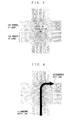
- FIG. 2 is a flowchart showing an example of the operation executed by the target intersection operation part 5, the recommended lane operation part 6, and the guidance part 7 of FIG. 1.
- FIG. 3 is an exemplary illustration of an intersection image generated by the guidance part 7.
- FIGS. 4 to 6 are illustrations of intersection images each generated by combining the intersection image of FIG. 3 with a running path, which is generated under later-described first to third techniques, respectively.
- FIG. 7 is an illustration demonstrating a case where two successive target intersections are in close proximity.
- FIG. 8 is an exemplary illustration of an intersection image generated under a fourth technique.
- FIGS. 9 and 10 are exemplary illustrations of intersection images displayed under a fifth technique.
- the target intersection operation part 5 searches and specifies any target intersection for guidance based on the route information received from the route search part 3 and the map data received from the map data storage part 2 (step S11). Then, for each of those specified target intersections, the recommended lane operation part 6 reads data relating the number of lanes of roads to be connected, the lane control, and the like (hereinafter, lane data) from the map data storage part 2, and generates recommended lane information (step S12). This recommended lane information indicates which lanes are recommended for the driver's entering into and exiting from the intersection.
- the recommended lane information to be generated for the target intersection A is "to enter (road M): far-right lane, to exit (road N): far-left lane”.
- the guidance part 7 Based on the target intersection information provided by the target intersection operation part 5 and the lane data read from the map data storage part 2, the guidance part 7 generates an intersection image for each of the target intersections (step S13).
- the intersection image is simplified optimally for lane guidance, and referred to here is information about the number of lanes on roads to be connected to the intersection and the bearings at which the roads are connected thereto.
- FIG. 3 shows an exemplary simplified intersection image generated thereby.
- the guidance part 7 For each of the target intersections, the guidance part 7 then generates, based on the recommended lane information received from the recommended lane operation part 6, a running path which passes through the recommended enter and exit lanes. Thus generated running paths are each combined with the corresponding intersection image (step S14).
- the guidance part 7 then outputs the lane guidance information to the output device 8 with a predetermined timing (for example, 500m before the target intersection) to display thus generated intersection image on a display thereof (step S15).
- steps S11 to S15 displayed for lane guidance are such simplified images of the target intersections.
- step S14 the techniques, in more concrete manner, for generating a running path and combining the path with an intersection image.
- the recommended enter lane is a far right, and the recommended exit lane a far left.
- First, with a first technique, generated is a running path represented by one arrow directing from the recommended enter lane to the recommended exit lane (FIG. 4).
- the first technique allows the driver to understand at a glance how to go through the intersection by taking which lane. In this sense, lane guidance offered thereby is driver friendly.
- the recommended lane operation part 6 needs to calculate, in step S12, the level of recommendation for each exit lane.
- the level of recommendation may be represented by discrete or consecutive numbers.
- the level of recommendation can be freely set depending on conditions such as a distance to the next target intersection, any decrease in road width, or the presence or absence of a bus stop.
- the second technique also allows the driver to understand at a glance how to go through the intersection by taking which lane, and furthermore, leaves lane selection to the driver's discretion by showing him/her the level of recommendation for each exit lane. In this sense, lane guidance offered thereby is more driver friendly.
- a third technique displayed are grounds for lane recommendation in addition to the running path generated based on the above first and second techniques (FIGS. 6a and 6b) .
- the recommended lane operation part 6 needs to calculate and find, in step S12, the grounds for the lane recommendation for each target intersection based on the searched route and the lane data.
- icons are used to show the driver the distance and the heading direction to the next intersection, thereby succeeding in explicitly indicating the driver the grounds for the lane recommendation.
- the driver can additionally see the grounds for the lane recommendation, therefore can rest assured.
- FIG. 7 Displayed in such case is one intersection image which is the combination of these target intersection images (see FIG. 8).
- FIGS. 7 and 8 two target intersections x and y are exemplarily in close proximity.
- the target intersection operation part 5 determines whether two or more target intersections among those specified in step S11 are located in a row in close proximity. If determined yes, a flag is set in the target intersection information. The guidance part 7 then refers to the flag, and generated in step S13 thereby becomes a simplified intersection image which is the combination of those target intersections (combined intersection image) . Lastly, the guidance part 7 represents a running path between the recommended enter lane and the recommended exit lane by one or more arrows. In FIG. 8. the running path is exemplarily represented by two arrows.
- the fourth technique is effective for a case where guidance has to be continuously displayed at short intervals, for example, where the vehicle successively makes left and right turns in a short distance by displaying one combined intersection image. Therefore, the driver can figure out at a glance what is coming and how to go through the intersections ahead in advance.
- a fifth technique which displays all of the target intersections on the searched route in order (see FIG. 9).
- every intersection image generated by the guidance part 7 for each target intersection is outputted to the output part 8 in order from the departure point.
- the driver can grasp the entire route in advance with the information about the recommended lanes for intersections ahead.
- the information is presented with no consideration for the distance between the intersections and direction. If all intersection images do not fit in a screen, the screen may be scrolled up manually by the user or automatically. As shown in FIG. 10, the information may be displayed additionally with the distance between the intersections, the intersections by name, roads by number, and the like.
- a lane image representing only the lane control information in a simplified manner may be presented together with the intersection image.
- a running path between recommended lanes for entering into and exiting from a target intersection is represented by one or more arrows, achieving visual guidance on a map which covers the running path.
- the lane guidance offered thereby is driver friendly as the driver can understand at a glance how to go through a target intersection by taking which lane.
- a running path is presumably represented by one or more arrows directing from the recommended enter lane to the recommended exit lane, that is, by a solid line (FIGS. 4 to 6, and 8 to 10).
- This is not restrictive, and may be a broken or dotted line as long as it serves as a running path, may be an arrow structured by small-sized arrows, or may be represented by successively arranged objects such as circle (dot) and triangle.
Landscapes
- Engineering & Computer Science (AREA)
- Radar, Positioning & Navigation (AREA)
- Remote Sensing (AREA)
- Automation & Control Theory (AREA)
- Physics & Mathematics (AREA)
- General Physics & Mathematics (AREA)
- Navigation (AREA)
- Traffic Control Systems (AREA)
- Instructional Devices (AREA)
Abstract
Description
- The present invention relates to a lane guidance display method, and a navigation device and a recording medium for realizing the method. More specifically, the lane guidance display method is employed by the navigation device mounted in a vehicle, for example, and used to guide the vehicle on a display which lane to take to enter an intersection or exit therefrom. The recording medium contains a program for executing this method.
- There have been developed various navigation devices which are of a type mounted in a vehicle, for example, to guide a vehicle from a departure point to a destination or a stopover. Displayed by such conventional navigation device is a map covering a driving route with heading direction by voice, optionally, when needed. For example, before an intersection at where the vehicle is supposed to turn left, the driver hears such voice as "please take a left turn at the next intersection".
- At an intersection on a road with several lanes, the driver may need to follow lane control when turning right or left, or going straight. If this is the case, such guidance as "take a left turn at the next intersection" is not helpful enough for the driver to decide which lane to take. The driver has to look for traffic signs and road markings, for example, for information relating such lane control. The problem herein is, if the driver is unfamiliar with the road, he/she may often find it difficult to decide which lane to take until the last minute. The reason lies in the fact that such information relating lane control (traffic signs, and the like) is often presented in the very close vicinity of the intersection. Therefore, when the driver is unfamiliar with the road, such conventional route guidance does not provide him/her with much assistance, and consequently results in sudden lane change or failure in lane change, preventing the driver from keeping track of the searched route.
- To get around such problem, the recent type of navigation device has started to guide the vehicle on the lane basis for additional guidance. For example, Japanese Patent Laid-Open Publication No. 2000-18956 discloses such vehicle-mounted navigation device, providing a lane guidance by voice for every intersection on a driving route between a departure point and a destination or a stopover in consideration of heading direction. For example, when the vehicle is supposed to turn left at the next intersection, the driver hears a voice saying "please move into a far left lane, and keep going" before hearing "please take a left turn at the next intersection".
- Here, if the driver is unskilled in driving or unfamiliar with the area, he/she may also want to know on which lane he/she is supposed to be when exiting the intersection. That is, in a case where the vehicle needs to make turns in a row, for example first left and then right, in a short distance on the roads with several lanes, the most preferred is taking a far right lane after turning left.
- In such conventional navigation device as offering the lane guidance only when the vehicle comes in close vicinity of an intersection ahead, if the lane guidance cannot catch up with such successive turns, one mistake of exiting from a wrong lane at the first intersection will lead to failure in entering an appropriate lane at the next intersection. This is because, the driver is more likely to miss information relating lane control when exiting from the intersection than entering. As a result, as described above, this leads to sudden lane change or failure in lane change, preventing the driver from keeping track of the searched route.
- In the above conventional navigation device, lane guidance is offered by voice as appropriate together with the map of running route on the display. The issue here is, the driver needs to correctly understand what the voice is saying (for example, distinguish between "left turn" and "right turn"), and such lane guidance by voice is not understandable at a glance and intuitive as map display. Further, if the driver fails to hear the lane guidance (for example, due to loud music or the driver being on the cellular phone), the lane guidance does not provide him/her much assistance.
- Therefore, an object of the present invention is to provide a lane guidance display method for displaying a map of running route and guiding a vehicle which lane to take both at entering an intersection and exiting therefrom, a navigation device for employing the method, and a recording medium containing a program for executing the method.
- The present invention has the following features to attain the object above.
- A first aspect of the present invention is directed to a lane guidance display method for guiding, on a screen, a vehicle which lane to take to go through an intersection, the method comprising the steps of:
- searching for a guidance route from a departure point to a destination or a stopover based on map data including lane data, which is regarding the number of lanes and lane control of roads to be connected to the intersection;
- specifying an intersection for guidance (target intersection) located on the guidance route;
- determining, based on the guidance route and the lane data, the recommended enter lane for entering the target intersection and the recommended exit lane for exiting therefrom; and
- guiding the vehicle by displaying the recommended enter and exit lanes on the screen.
-
- As described above, in the first aspect, lanes recommended respectively for entering into and exiting from a target intersection on a guidance route are determined, and then guidance is preformed. Accordingly, a vehicle can be guided with such lanes helpful for smooth travel, and therefore lane guidance offered thereby is driver friendly.
- Preferably, the guiding step comprises the steps of:
- generating an intersection image of the target intersection for lane guidance based on the lane data;
- generating a running path for the target intersection which passes through both the recommended enter lane and the recommended exit lane; and
- displaying, on the screen, a lane guidance intersection image which is a combination of the intersection image and the running path.
-
- As such, the lanes recommended for entering into and exiting from the intersection (recommended lanes) are represented by a running path connecting the recommended lanes on an intersection image (simplified, for example) of the target intersection. Accordingly, guidance can be visually offered on a map covering the running route on a screen. Thus, a driver of the vehicle can understand at a glance how to go through the intersection by taking which lane, and lane guidance made thereby is driver friendly.
- Also preferably, when the target intersection is plurally in proximity in a row, the intersection image generated in the intersection image generating step is a combination of the target intersections in proximity, and
the running path generated in the running path generating step passes through the target intersections in proximity. - As such, by generating and displaying an intersection image which is a combination of several target intersections, even if a vehicle successively makes left and right turns in a short distance and thus guidance cannot catch up therewith, the driver can figure out at a glance how to go through the intersection by taking which lane in advance.
- Also preferably, specified as the target intersection in the specifying step are all of the intersections found on the guidance route; and
displayed plurally and collectively in the displaying step is the lane guidance intersection image in order of the target intersections on the guidance route. - As such, the driver can grasp recommended lanes for the entire route in advance with no consideration for the distance between the actual intersections and direction.
- Here, the running path generated in the running path generating step may be represented by one or more successive arrows directing from the recommended enter lane to the recommended exit lane.
- In this manner, lane guidance offered thereby is driver friendly as allowing the driver to understand how to go through the intersection by taking which lane at a glance.
- Further, in the determining step, additionally calculated for each exit lane may be a lane level of recommendation, which is represented by discrete or successive numbers, and
the running path generated in the running path generating step may be represented, in various manners depending on the lane level of recommendation, by one or more successive arrows directed from the recommended enter lane to the recommended exit lane. - In this manner, the running path can be represented by such successive arrows in various manners depending on the lane level of recommendation. This leaves lane selection to the driver's discretion by showing him/her the level of recommendation for each exit lane, and in this sense, lane guidance offered thereby is driver friendly.
- Still further, in the determining step, a ground for the recommended enter and exit lanes may be additionally found, and
in the displaying step, an image based on the ground may be displayed together with the lane guidance intersection image. - In this manner, together with the running path represented by such successive arrows, the driver can see the grounds for the lane recommendation, therefore can rest assured in addition to the effects achieved in the foregoing.
- A second aspect of the present invention is directed to a navigation device for guiding a vehicle on a screen from a departure point to a destination or a stopover, the device comprising:
- a map data storage part for storing map data including lane data, which is regarding the number of lanes and lane control of roads to be connected to an intersection;
- a route search part for searching for, based on the map data, a guidance route from the departure point to the destination or the stopover;
- a vehicle position detection part for detecting a vehicle position on the map data;
- a target intersection operation part for searching for and specifying, based on the guidance route and the map data, an intersection for guidance on the guidance route (target intersection) ;
- the recommended lane operation part for determining, based on the guidance route, the lane data, and the target intersection, the recommended enter lane and the recommended exit lane for the target intersection;
- a guidance part for generating, based on the recommended enter and exit lanes and the lane data, lane guidance data required for display on the screen; and
- an output part for displaying guidance on the screen according to the lane guidance data.
-
- Preferably, as the lane guidance data, the guidance part
- generates an intersection image for lane guidance based on the lane data for the target intersection,
- generates a running path which passes through the recommended enter lane and the recommended exit lane for the target intersection, and
- generates a lane guidance intersection image which is a combination of the intersection image and the running path.
-
- Also preferably, when the target intersection is plurally in proximity in a row, the intersection image generated by the guidance part is a combination of the target intersections in proximity, and the running path generated thereby passes through the target intersections in proximity.
- Also preferably, the target intersection operation part specifies all of the intersections found on the guidance route as the target intersection, and
the guidance part outputs the lane guidance data to the output part to plurally and collectively display the lane guidance intersection image in order of the target intersections on the guidance route. - Here, the running path generated by the guidance part may be represented by one or more successive arrows directing from the recommended enter lane to the recommended exit lane.
- Further, additionally calculated by the recommended lane operation part may be a lane level of recommendation for each exit lane represented by discrete or successive numbers, and
the running path generated by the guidance part may be represented, in various manners depending on the lane level of recommendation, by one or more successive arrows directed from the recommended enter lane to the recommended exit lane. - Still further, the recommended lane operation part may additionally find a ground for the recommended enter and exit lanes, and
the guidance part may output the lane guidance data to the output part to display an image based on the ground together with the lane guidance intersection image. - As is the second aspect, a navigation device is so structured as to execute the lane guidance display method of the above first aspect, thereby performing the effective lane guidance of the present invention.
- A third aspect of the present invention is directed to a recording medium on which a lane guidance display method for guiding, on a screen, a vehicle which lane to take to go through an intersection is recorded as a program executable on a computer, the program at least carries out the steps of:
- searching for a guidance route from a departure point to a destination or a stopover based on map data including lane data, which is regarding the number of lanes and lane control of roads to be connected to the intersection;
- specifying an intersection for guidance (hereinafter, refers to as a target intersection) located on the guidance route;
- determining, based on the guidance route and the lane data, the recommended enter lane for entering the target intersection and the recommended exit lane for exiting therefrom;
- generating an intersection image of the target intersection for lane guidance based on the lane data;
- generating a running path for the target intersection which passes through both the recommended enter lane and the recommended exit lane; and
- displaying, on the screen, a lane guidance intersection image which is a combination of the intersection image and the running path.
-
- Here, the running path generated in the running path generating step may be represented by one or more successive arrows directing from the recommended enter lane to the recommended exit lane.
- Further, in the determining step, additionally calculated for each exit lane may be a lane level of recommendation, which is represented by discrete or successive numbers, and
the running path generated in the running path generating step may be represented, in various manners depending on the lane level of recommendation, by one or more successive arrows directed from the recommended enter lane to the recommended exit lane. - Still further, in the determining step, a ground for the recommended enter and exit lanes may be additionally found, and
in the displaying step, an image based on the ground may be displayed together with the lane guidance intersection image. - As is the third aspect, a program carrying out the lane guidance display method of the first aspect is recorded on a medium, whereby the method can be supplied to an existing device in the form of software.
- These and other objects, features, aspects and advantages of the present invention will become more apparent from the following detailed description of the present invention when taken in conjunction with the accompanying drawings.
-
- FIG. 1 is a block diagram of the construction of a navigation device employing a lane guidance display method according to an embodiment of the present invention;
- FIG. 2 is a flowchart showing an example of the operation of a target intersection operation part, the recommended lane operation part, and a guidance part;
- FIG. 3 is an exemplary illustration of an
intersection image generated by the
guidance part 7; - FIG. 4 is an exemplary illustration of an intersection image generated by combining the running path generated under a first technique with the intersection image of FIG. 3;
- FIG. 5 is an exemplary illustration of an intersection image generated by combining the running path generated under a second technique with the intersection image of FIG. 3;
- FIG. 6 is an exemplary illustration of an intersection image generated by combining the running path generated under a third technique with the intersection image of FIG. 3;
- FIG. 7 is an illustration demonstrating a case where two successive target intersections are in close proximity;
- FIG. 8 is an exemplary illustration of an intersection image generated under a fourth technique;
- FIG. 9 is an exemplary illustration of an intersection image displayed under a fifth technique; and
- FIG. 10 is another exemplary illustration of an intersection image displayed under the fifth technique.
-
- FIG. 1 is a block diagram showing the structure of a navigation device employing a lane guidance display method according to an embodiment of the present invention. In FIG. 1, the navigation device includes an
input part 1, a mapdata storage part 2 , aroute search part 3, aposition detection part 4, a targetintersection operation part 5, the recommendedlane operation part 6, aguidance part 7, and anoutput part 8. - The lane guidance display method of the present invention is basically realized by the target
intersection operation part 5, the recommendedlane operation part 6, and theguidance part 7. For easy understanding, the entire navigation device employing the lane guidance display method will be first outlined. Note that the constructions of theinput part 1, the mapdata storage part 2, theroute search part 3, theposition detection part 4, and theoutput part 8 are not restricted to those exemplified in the following description, and any construction used in known navigation device may be adopted. Here, the known navigation device is not restricted to a vehicle-mounted type, and may be in the form of navigation software operable on computer devices. - The
input part 1 includes a remote controller, a touch sensor, a keyboard, a mouse, and the like, operated by a user, for example, and is used to input instructions such as selection of functions of a map display unit (change of the item to be processed, switch of the map, change of the hierarchical level, and the like), setting of a departure point and a destination (including a stopover, the same is applicable hereinafter), and selection of a route search mode. Instruction information outputted from theinput part 1 is supplied to theroute search part 3 and theguidance part 7. - The map
data storage part 2 includes an optical disk (CD, DVD, and the like) , a hard disk, a large-capacity memory, and the like, for storing information relating a road network (map data) such as the connection status, coordinates, shapes, attributes, and information about lane control for respective intersections and roads. The map data is assumed to include information about the number of lanes and lane control of roads connected to the respective intersections. The map data may be two-dimensional map data or three-dimensional map data. The map data stored in the mapdata storage part 2 is read and used as appropriate by theroute research part 3, the targetintersection operation part 5, the recommendedlane operation part 6, and theguidance part 7. - The
position detection part 4 includes a GPS, a radio beacon receiver, a vehicle speed sensor, various speed sensors, an absolute bearing sensor, and the like, for detecting the current position of a vehicle. Information about the vehicle's current position provided by theposition detection part 4 is supplied to theroute search part 3 and theguidance part 7. - The
route search part 3 reads map data in a necessary range from the mapdata storage part 2 according to the instruction information received from theinput part 1. Theroute search part 3 then determines the departure point and the destination based on the received instruction information such as location information, and searches for a minimum-cost route from the departure point to the destination in consideration of intersection traffic control and one-way traffic control if any. - To state a specific example, upon receipt of an instruction of executing the route search mode from the
input part 1, theroute search part 3 sets, as the departure point of the search, either the departure point inputted into theinput part 1 or the vehicle's current position detected by theposition detection part 4, and sets the destination inputted into theinput part 1 as the destination of the search. Theroute search part 3 also reads map data in a range covering the area from the departure point to the destination from the mapdata storage part 2. Then, theroute search part 3 searches for a guidance route (for example, a shortest-time route or a shortest-distance route) from the departure point to the destination on the read map data. As an algorithm for the route search executed by theroute search part 3, known Dijkstra algorithm, for example, is used. - Upon completion of the route search, the
route search part 3 outputs the resultant route information to the targetintersection operation part 5, the recommendedlane operation part 6, and theguidance part 7. - The target
intersection operation part 5 searches and specifies any intersection on the searched route based on the route information received from theroute search part 3 and the map data (the same map data as the one read by the route search part 3) received from the map data storage part 2 (hereinafter, thus specified intersection is referred to as target intersection). Here, specified may be every intersection found on the searched route, or only any specific intersection required to be guided in a predetermined manner. The specific intersection includes that where roads with several lanes intersect with one another or where the vehicle is supposed to turn right or left. Information about those specified target intersections is outputted to the recommendedlane operation part 6 and theguidance part 7. - For each of those target intersections, the recommended
lane operation part 6 then determines which lane to recommend the driver respectively for entering and exiting, and generates information about thus determined recommended lanes. This determination is made based on the map data (the number of lanes, lane control information, and the like) received from the mapdata storage part 2, the route information from theroute search part 3, and the information about those target intersections provided by the targetintersection operation part 5. Thus generated recommended lane information is outputted to theguidance part 7. - Upon receipt of an instruction of executing a route guidance mode from the
input part 1, theguidance part 7 generates guidance information for directional guidance on the map. This is done based on the route information provided by theroute search part 3, the information about the vehicle's current position received from theposition detection part 4, and the map data received from the mapdata storage part 2. Theguidance part 7 also executes a predetermined operation to be described later, based on the map data, the target intersection information received from the targetintersection operation part 5, and the recommended lane information provided by the recommendedlane operation part 6, and generates lane guidance information for each of the target intersections. Theguidance part 7 then outputs the guidance information and the lane guidance information to theoutput part 8 with a predetermined timing. - The
output part 8 includes a display device (a liquid crystal display, a CRT display, and the like) and displays an image for guidance on a screen based on the guidance information and the lane guidance information received from theguidance part 7. - Hereinafter, with reference to FIGS. 2 to 10, the lane guidance display method of this embodiment will be described in a concrete manner.
- FIG. 2 is a flowchart showing an example of the operation executed by the target
intersection operation part 5, the recommendedlane operation part 6, and theguidance part 7 of FIG. 1. FIG. 3 is an exemplary illustration of an intersection image generated by theguidance part 7. FIGS. 4 to 6 are illustrations of intersection images each generated by combining the intersection image of FIG. 3 with a running path, which is generated under later-described first to third techniques, respectively. FIG. 7 is an illustration demonstrating a case where two successive target intersections are in close proximity. FIG. 8 is an exemplary illustration of an intersection image generated under a fourth technique. FIGS. 9 and 10 are exemplary illustrations of intersection images displayed under a fifth technique. - First, referring to FIG. 2, the target
intersection operation part 5 searches and specifies any target intersection for guidance based on the route information received from theroute search part 3 and the map data received from the map data storage part 2 (step S11). Then, for each of those specified target intersections, the recommendedlane operation part 6 reads data relating the number of lanes of roads to be connected, the lane control, and the like (hereinafter, lane data) from the mapdata storage part 2, and generates recommended lane information (step S12). This recommended lane information indicates which lanes are recommended for the driver's entering into and exiting from the intersection. For example, in a case where a vehicle on a 4-lane road M turns right at an arbitrary target intersection A to enter a 3-lane road N, and then turns left at the next target intersection B, the recommended lane information to be generated for the target intersection A is "to enter (road M): far-right lane, to exit (road N): far-left lane". - Next, based on the target intersection information provided by the target
intersection operation part 5 and the lane data read from the mapdata storage part 2, theguidance part 7 generates an intersection image for each of the target intersections (step S13). Here, the intersection image is simplified optimally for lane guidance, and referred to here is information about the number of lanes on roads to be connected to the intersection and the bearings at which the roads are connected thereto. FIG. 3 shows an exemplary simplified intersection image generated thereby. For each of the target intersections, theguidance part 7 then generates, based on the recommended lane information received from the recommendedlane operation part 6, a running path which passes through the recommended enter and exit lanes. Thus generated running paths are each combined with the corresponding intersection image (step S14). Theguidance part 7 then outputs the lane guidance information to theoutput device 8 with a predetermined timing (for example, 500m before the target intersection) to display thus generated intersection image on a display thereof (step S15). - Upon completion of steps S11 to S15, displayed for lane guidance are such simplified images of the target intersections.
- With reference to FIGS. 4 to 10, next to be described is the techniques, in more concrete manner, for generating a running path and combining the path with an intersection image (step S14 described above). In the description below, presumably, the recommended enter lane is a far right, and the recommended exit lane a far left.
- First, with a first technique, generated is a running path represented by one arrow directing from the recommended enter lane to the recommended exit lane (FIG. 4).
- The first technique allows the driver to understand at a glance how to go through the intersection by taking which lane. In this sense, lane guidance offered thereby is driver friendly.
- Next, with a second technique, generated are several running paths each represented by an arrow, sharing the same recommended enter lane but directing to each different exit lane. Here, those arrows are differently colored depending on their level of recommendation, indicating from which lane the driver is more advised to exit the intersection (FIG. 5a). The arrows may be changed in width depending on their level of recommendation (FIG. 5b). With the second technique, the recommended
lane operation part 6 needs to calculate, in step S12, the level of recommendation for each exit lane. The level of recommendation may be represented by discrete or consecutive numbers. Here, the level of recommendation can be freely set depending on conditions such as a distance to the next target intersection, any decrease in road width, or the presence or absence of a bus stop. - The second technique also allows the driver to understand at a glance how to go through the intersection by taking which lane, and furthermore, leaves lane selection to the driver's discretion by showing him/her the level of recommendation for each exit lane. In this sense, lane guidance offered thereby is more driver friendly.
- Under a third technique, displayed are grounds for lane recommendation in addition to the running path generated based on the above first and second techniques (FIGS. 6a and 6b) . With the third technique, the recommended
lane operation part 6 needs to calculate and find, in step S12, the grounds for the lane recommendation for each target intersection based on the searched route and the lane data. In FIGS. 6a and 6b, icons are used to show the driver the distance and the heading direction to the next intersection, thereby succeeding in explicitly indicating the driver the grounds for the lane recommendation. - With the third technique, together with the effects achieved under the first and second techniques, the driver can additionally see the grounds for the lane recommendation, therefore can rest assured.
- Next, a fourth technique is applied to a case where two or more successive target intersections are in close proximity (see FIG. 7). Displayed in such case is one intersection image which is the combination of these target intersection images (see FIG. 8). In FIGS. 7 and 8, two target intersections x and y are exemplarily in close proximity.
- With the fourth technique, the target
intersection operation part 5 determines whether two or more target intersections among those specified in step S11 are located in a row in close proximity. If determined yes, a flag is set in the target intersection information. Theguidance part 7 then refers to the flag, and generated in step S13 thereby becomes a simplified intersection image which is the combination of those target intersections (combined intersection image) . Lastly, theguidance part 7 represents a running path between the recommended enter lane and the recommended exit lane by one or more arrows. In FIG. 8. the running path is exemplarily represented by two arrows. - The fourth technique is effective for a case where guidance has to be continuously displayed at short intervals, for example, where the vehicle successively makes left and right turns in a short distance by displaying one combined intersection image. Therefore, the driver can figure out at a glance what is coming and how to go through the intersections ahead in advance.
- Described next is a fifth technique, which displays all of the target intersections on the searched route in order (see FIG. 9). With the fifth technique, every intersection image generated by the
guidance part 7 for each target intersection is outputted to theoutput part 8 in order from the departure point. - In this manner, the driver can grasp the entire route in advance with the information about the recommended lanes for intersections ahead. Here, the information is presented with no consideration for the distance between the intersections and direction. If all intersection images do not fit in a screen, the screen may be scrolled up manually by the user or automatically. As shown in FIG. 10, the information may be displayed additionally with the distance between the intersections, the intersections by name, roads by number, and the like. Under the fifth technique, a lane image representing only the lane control information in a simplified manner may be presented together with the intersection image.
- As described in the foregoing, with the lane guidance display method of the present invention, a running path between recommended lanes for entering into and exiting from a target intersection is represented by one or more arrows, achieving visual guidance on a map which covers the running path.
- Accordingly, the lane guidance offered thereby is driver friendly as the driver can understand at a glance how to go through a target intersection by taking which lane.
- With the first to fifth techniques, a running path is presumably represented by one or more arrows directing from the recommended enter lane to the recommended exit lane, that is, by a solid line (FIGS. 4 to 6, and 8 to 10). This is not restrictive, and may be a broken or dotted line as long as it serves as a running path, may be an arrow structured by small-sized arrows, or may be represented by successively arranged objects such as circle (dot) and triangle.
- While the invention has been described in detail, the foregoing description is in all aspects illustrative and not restrictive. It is understood that numerous other modifications and variations can be devised without departing from the scope of the invention.
Claims (21)
- A lane guidance display method for guiding, on a screen, a vehicle which lane to take to go through an intersection, said method comprising the steps of:searching for a guidance route from a departure point to a destination or a stopover based on map data including lane data, which is regarding the number of lanes and lane control of roads to be connected to the intersection;specifying an intersection for guidance (hereinafter, refers to as a target intersection) located on said guidance route (S11) ;determining, based on said guidance route and said lane data, the recommended enter lane for entering said target intersection and the recommended exit lane for exiting therefrom (S12) ; andguiding the vehicle by displaying said recommended enter and exit lanes on the screen.
- The lane guidance display method according to claim 1, wherein said guiding step comprises the steps of:generating an intersection image of said target intersection for lane guidance based on said lane data (S13) ;generating a running path for said target intersection which passes through both said recommended enter lane and said recommended exit lane (S14) ; anddisplaying, on the screen, a lane guidance intersection image which is a combination of said intersection image and said running path (S14, S15).
- The lane guidance display method according to claim 2, wherein,when said target intersection is plurally in proximity in a row, said intersection image generated in said intersection image generating step (S13) is a combination of the target intersections in proximity, andsaid running path generated in said running path generating step (S14) passes through said target intersections in proximity.
- The lane guidance display method according to claim 2, wherein,specified as said target intersection in said specifying step (S11) are all of the intersections found on said guidance route; anddisplayed plurally and collectively in said displaying step (S14, S15) is said lane guidance intersection image in order of said target intersections on said guidance route.
- The lane guidance display method according to claim 2, wherein
said running path generated in said running path generating step (S14) is represented by one or more successive arrows directing from said recommended enter lane to said recommended exit lane. - The lane guidance display method according to claim 2, wherein,in said determining step (S12), additionally calculated for each exit lane is a lane level of recommendation, which is represented by discrete or successive numbers, andsaid running path generated in said running path generating step (S14) is represented, in various manners depending on said lane level of recommendation, by one or more successive arrows directed from said recommended enter lane to said recommended exit lane.
- The lane guidance display method according to claim 5, wherein,in said determining step (S12), a ground for said recommended enter and exit lanes is additionally found, andin said displaying step (S14, S15) , an image based on said ground is displayed together with said lane guidance intersection image.
- The lane guidance display method according to claim 6, wherein,in said determining step (S12), a ground for said recommended enter and exit lanes is additionally found, andin said displaying step (S14, S15), an image based on said ground is displayed together with said lane guidance intersection image.
- A navigation device for guiding a vehicle on a screen from a departure point to a destination or a stopover, said device comprising:a map data storage part (2) for storing map data including lane data, which is regarding the number of lanes and lane control of roads to be connected to an intersection;a route search part (3) for searching for, based on said map data, a guidance route from the departure point to the destination or the stopover;a vehicle position detection part (4) for detecting a vehicle position on said map data;a target intersection operation part (5) for searching for and specifying, based on said guidance route and said map data, an intersection for guidance on said guidance route (hereinafter, refers to as a target intersection) ;the recommended lane operation part (6) for determining, based on said guidance route, said lane data, and said target intersection, the recommended enter lane and the recommended exit lane for said target intersection;a guidance part (7) for generating, based on said recommended enter and exit lanes and said lane data, lane guidance data required for display on the screen; andan output part (8) for displaying guidance on the screen according to said lane guidance data.
- The navigation device according to claim 9, wherein, as said lane guidance data, said guidance part (7)generates an intersection image for lane guidance based on said lane data for said target intersection,generates a running path which passes through said recommended enter lane and said recommended exit lane for said target intersection, andgenerates a lane guidance intersection image which is a combination of said intersection image and said running path.
- The navigation device according to claim 10, wherein,
when said target intersection is plurally in proximity in a row, said intersection image generated by said guidance part (7) is a combination of the target intersections in proximity, and said running path generated thereby passes through said target intersections in proximity. - The navigation device according to claim 10, whereinsaid target intersection operation part (5) specifies all of the intersections found on said guidance route as said target intersection, andsaid guidance part (7) outputs said lane guidance data to said output part (8) to plurally and collectively display said lane guidance intersection image in order of said target intersections on said guidance route.
- The navigation device according to claim 10, wherein
said running path generated by said guidance part (7) is represented by one or more successive arrows directing from said recommended enter lane to said recommended exit lane. - The navigation device according to claim 10, whereinadditionally calculated by said recommended lane operation part (6) is a lane level of recommendation for each exit lane represented by discrete or successive numbers, andsaid running path generated by said guidance part (7) is represented, in various manners depending on said lane level of recommendation, by one or more successive arrows directed from said recommended enter lane to said recommended exit lane.
- The navigation device according to claim 13, whereinsaid recommended lane operation part (6) additionally finds a ground for said recommended enter and exit lanes, andsaid guidance part (7) outputs said lane guidance data to said output part (8) to display an image based on said ground together with said lane guidance intersection image.
- The navigation device according to claim 14, whereinsaid recommended lane operation part (6) additionally finds a ground for said recommended enter and exit lanes, andsaid guidance part (7) outputs said lane guidance data to said output part (8) to display an image based on said ground together with said lane guidance intersection image.
- A recording medium on which a lane guidance display method for guiding, on a screen, a vehicle which lane to take to go through an intersection is recorded as a program executable on a computer, said program at least carries out the steps of:searching for a guidance route from a departure point to a destination or a stopover based on map data including lane data, which is regarding the number of lanes and lane control of roads to be connected to the intersection;specifying an intersection for guidance (hereinafter, refers to as a target intersection) located on said guidance route (S11) ;determining, based on said guidance route and said lane data, the recommended enter lane for entering said target intersection and the recommended exit lane for exiting therefrom (S12) ;generating an intersection image of said target intersection for lane guidance based on said lane data (S13) ;generating a running path for said target intersection which passes through both said recommended enter lane and said recommended exit lane (S14) ; anddisplaying, on the screen, a lane guidance intersection image which is a combination of said intersection image and said running path (S14, S15).
- The recording medium according to claim 17, wherein
said running path generated in said running path generating step (S14) is represented by one or more successive arrows directing from said recommended enter lane to said recommended exit lane. - The recording medium according to claim 17, wherein,in said determining step (S12), additionally calculated for each exit lane is a lane level of recommendation, which is represented by discrete or successive numbers, andsaid running path generated in said running path generating step (S14) is represented, in various manners depending on said lane level of recommendation, by one or more successive arrows directed from said recommended enter lane to said recommended exit lane.
- The recording medium according to claim 18, wherein,in said determining step (S12), a ground for said recommended enter and exit lanes is additionally found, andin said displaying step (S14, S15), an image based on said ground is displayed together with said lane guidance intersection image.
- The recording medium according to claim 19, wherein,in said determining step (S12), a ground for said recommended enter and exit lanes is additionally found, andin said displaying step (S14, S15), an image based on said ground is displayed together with said lane guidance intersection image.
Applications Claiming Priority (2)
| Application Number | Priority Date | Filing Date | Title |
|---|---|---|---|
| JP2000037873 | 2000-02-16 | ||
| JP2000037873A JP3455153B2 (en) | 2000-02-16 | 2000-02-16 | Lane guidance display method at intersection, navigation device thereof, and recording medium |
Publications (2)
| Publication Number | Publication Date |
|---|---|
| EP1146315A2 true EP1146315A2 (en) | 2001-10-17 |
| EP1146315A3 EP1146315A3 (en) | 2005-01-19 |
Family
ID=18561697
Family Applications (1)
| Application Number | Title | Priority Date | Filing Date |
|---|---|---|---|
| EP01102854A Withdrawn EP1146315A3 (en) | 2000-02-16 | 2001-02-13 | Lane guidance display method, and navigation device and recording medium for realizing the method |
Country Status (3)
| Country | Link |
|---|---|
| US (2) | US6388582B2 (en) |
| EP (1) | EP1146315A3 (en) |
| JP (1) | JP3455153B2 (en) |
Cited By (2)
| Publication number | Priority date | Publication date | Assignee | Title |
|---|---|---|---|---|
| DE102006039634A1 (en) * | 2006-08-24 | 2008-03-13 | Bayerische Motoren Werke Ag | navigation system |
| WO2019206301A1 (en) * | 2018-04-27 | 2019-10-31 | Beijing Didi Infinity Technology And Development Co., Ltd. | Systems and methods for lane broadcast |
Families Citing this family (106)
| Publication number | Priority date | Publication date | Assignee | Title |
|---|---|---|---|---|
| JP4380026B2 (en) * | 2000-06-05 | 2009-12-09 | 株式会社デンソー | Navigation device and recording medium |
| US7552008B2 (en) * | 2001-07-18 | 2009-06-23 | Regents Of The University Of Minnesota | Populating geospatial database for onboard intelligent vehicle applications |
| DE10146744A1 (en) * | 2001-09-22 | 2003-04-17 | Bosch Gmbh Robert | Method and system for providing lane recommendations |
| EP1308695A1 (en) * | 2001-11-06 | 2003-05-07 | Matsushita Electric Industrial Co., Ltd. | Vehicle mounted display system |
| JP3864846B2 (en) * | 2002-05-21 | 2007-01-10 | 株式会社デンソー | Navigation device |
| KR20040001979A (en) * | 2002-06-29 | 2004-01-07 | 현대자동차주식회사 | Variable traffic line alarm controlling device of navigation system for vehicle |
| JP2004239740A (en) * | 2003-02-05 | 2004-08-26 | Aisin Aw Co Ltd | Navigation device |
| JP4013797B2 (en) * | 2003-03-10 | 2007-11-28 | 株式会社デンソー | Navigation device |
| JP2004286559A (en) * | 2003-03-20 | 2004-10-14 | Mitsubishi Electric Corp | Vehicle navigation system and route guidance method |
| JP4261967B2 (en) * | 2003-04-18 | 2009-05-13 | アイシン・エィ・ダブリュ株式会社 | Vehicle navigation apparatus, program for the apparatus, and recording medium |
| JP4138574B2 (en) * | 2003-05-21 | 2008-08-27 | 株式会社日立製作所 | Car navigation system |
| US9341485B1 (en) * | 2003-06-19 | 2016-05-17 | Here Global B.V. | Method and apparatus for representing road intersections |
| KR100811232B1 (en) * | 2003-07-18 | 2008-03-07 | 엘지전자 주식회사 | Turn-by-turn navigation system and how to guide |
| JP4145756B2 (en) * | 2003-09-02 | 2008-09-03 | アルパイン株式会社 | NAVIGATION DEVICE, NAVIGATION METHOD, PROGRAM THEREOF, AND RECORDING MEDIUM CONTAINING THE PROGRAM |
| EP1544829B1 (en) * | 2003-12-19 | 2017-02-15 | Samsung Electronics Co., Ltd. | Navigation system and navigation method |
| JP4211620B2 (en) * | 2004-01-30 | 2009-01-21 | 株式会社デンソー | Car navigation system |
| JP4459668B2 (en) * | 2004-03-12 | 2010-04-28 | クラリオン株式会社 | Navigation device, method and program |
| JP2005292040A (en) * | 2004-04-02 | 2005-10-20 | Matsushita Electric Ind Co Ltd | Navigation device |
| JP4466238B2 (en) * | 2004-07-07 | 2010-05-26 | 株式会社デンソー | Vehicle navigation device |
| JP4049131B2 (en) * | 2004-07-07 | 2008-02-20 | 株式会社デンソー | Vehicle navigation device |
| JP4059232B2 (en) * | 2004-07-13 | 2008-03-12 | 株式会社デンソー | Navigation device |
| JP4466277B2 (en) * | 2004-08-18 | 2010-05-26 | 株式会社デンソー | Navigation device and program |
| JP2006064661A (en) * | 2004-08-30 | 2006-03-09 | Denso Corp | Navigation device |
| JP2006119120A (en) * | 2004-09-27 | 2006-05-11 | Denso Corp | Car navigation system |
| JP2006153757A (en) * | 2004-11-30 | 2006-06-15 | Denso Corp | Route guidance apparatus and program |
| JP4246693B2 (en) | 2004-12-24 | 2009-04-02 | 富士通テン株式会社 | Driving assistance device |
| JP4581674B2 (en) * | 2004-12-24 | 2010-11-17 | アイシン・エィ・ダブリュ株式会社 | Route guidance system and route guidance method |
| KR101047719B1 (en) * | 2005-02-16 | 2011-07-08 | 엘지전자 주식회사 | Method and device for driving route guidance of moving object in navigation system |
| JP2006273230A (en) * | 2005-03-30 | 2006-10-12 | Aisin Aw Co Ltd | Vehicle controller and vehicle control method |
| US8788192B2 (en) * | 2005-05-18 | 2014-07-22 | International Business Machines Corporation | Navigation method, system or service and computer program product |
| JP2007024691A (en) * | 2005-07-15 | 2007-02-01 | Denso Corp | Lane guide device |
| JP4501840B2 (en) * | 2005-10-31 | 2010-07-14 | アイシン・エィ・ダブリュ株式会社 | Route guidance system and route guidance method |
| JP4506688B2 (en) * | 2006-02-28 | 2010-07-21 | アイシン・エィ・ダブリュ株式会社 | Navigation device |
| JP4495237B2 (en) * | 2006-03-24 | 2010-06-30 | パイオニア株式会社 | Information generating apparatus, information generating method, etc. |
| JP2008009915A (en) * | 2006-06-30 | 2008-01-17 | Pioneer Electronic Corp | Road sign determination apparatus, method and program |
| JP4770702B2 (en) * | 2006-10-31 | 2011-09-14 | アイシン・エィ・ダブリュ株式会社 | Route guidance system and route guidance method |
| KR100786023B1 (en) * | 2006-11-08 | 2007-12-17 | 팅크웨어(주) | Method for providing a plurality of lane information and a terminal for performing the method |
| WO2008062721A1 (en) * | 2006-11-20 | 2008-05-29 | Aisin Aw Co., Ltd. | Method and device for judging traveling state of vehicle |
| JP4869106B2 (en) * | 2007-02-28 | 2012-02-08 | アルパイン株式会社 | Navigation apparatus, intersection enlarged view display method, and map information creation method |
| US8467962B2 (en) * | 2007-03-23 | 2013-06-18 | Mitsubishi Electric Corporation | Navigation system and lane information display method |
| JP4825722B2 (en) * | 2007-04-27 | 2011-11-30 | アイシン・エィ・ダブリュ株式会社 | Route guidance system, navigation device, and route guidance method |
| US20080300776A1 (en) * | 2007-06-01 | 2008-12-04 | Petrisor Gregory C | Traffic lane management system |
| JP5035842B2 (en) * | 2007-11-02 | 2012-09-26 | アルパイン株式会社 | Navigation device |
| JP4985362B2 (en) * | 2007-11-30 | 2012-07-25 | アイシン・エィ・ダブリュ株式会社 | Navigation device, navigation method, and navigation program |
| US8346465B2 (en) * | 2008-02-26 | 2013-01-01 | Apline Electronics, Inc | Method and apparatus for determining and displaying meaningful cross street for navigation system |
| US20090216431A1 (en) | 2008-02-26 | 2009-08-27 | Tien Vu | Method and apparatus for adjusting distance for generating maneuver instruction for navigation system |
| JP2010026326A (en) * | 2008-07-22 | 2010-02-04 | Asahi Koyo Kk | Road network data generating device, vehicle guide path generating device, and method and program for them |
| JP5353097B2 (en) * | 2008-07-22 | 2013-11-27 | 朝日航洋株式会社 | Road network data generation device, intersection lane generation device, and method and program thereof |
| US20100131481A1 (en) * | 2008-11-26 | 2010-05-27 | Honeywell International Inc. | Methods for locating an item when a search mode is not selected |
| JP4435274B1 (en) * | 2009-08-04 | 2010-03-17 | キャンバスマップル株式会社 | Navigation device, navigation method, and navigation program |
| US20110153266A1 (en) * | 2009-12-23 | 2011-06-23 | Regents Of The University Of Minnesota | Augmented vehicle location system |
| US9026353B2 (en) * | 2010-02-26 | 2015-05-05 | Alpine Electronics, Inc. | Method and apparatus for displaying guidance for navigation system |
| DE102010014499B4 (en) * | 2010-04-10 | 2012-01-26 | Audi Ag | Method for operating a lane keeping assistance system for multi-lane turning in a motor vehicle |
| JP5663946B2 (en) * | 2010-05-13 | 2015-02-04 | トヨタ自動車株式会社 | Vehicle travel control device |
| DE102010029822A1 (en) | 2010-06-08 | 2011-12-08 | Bayerische Motoren Werke Aktiengesellschaft | Motor vehicle with a navigation system |
| US8374792B2 (en) * | 2010-07-30 | 2013-02-12 | Primordial Inc. | System and method for multi-resolution routing |
| JP5541103B2 (en) * | 2010-11-15 | 2014-07-09 | アイシン・エィ・ダブリュ株式会社 | Travel guidance device, travel guidance method, and computer program |
| DE102010052000A1 (en) * | 2010-11-19 | 2012-05-24 | Bayerische Motoren Werke Aktiengesellschaft | Method for issuing navigation instructions |
| JP5140864B2 (en) * | 2010-11-22 | 2013-02-13 | 株式会社小松製作所 | Unmanned vehicle travel system and travel route generation method |
| JP5565296B2 (en) * | 2010-12-21 | 2014-08-06 | アイシン・エィ・ダブリュ株式会社 | Route guidance device, route guidance method and computer program |
| DE102011006347B4 (en) * | 2011-03-29 | 2023-02-09 | Bayerische Motoren Werke Aktiengesellschaft | Process for outputting graphical driving instructions |
| US20120303265A1 (en) * | 2011-05-23 | 2012-11-29 | Microsoft Corporation | Navigation system with assistance for making multiple turns in a short distance |
| JP5724864B2 (en) * | 2011-12-13 | 2015-05-27 | アイシン・エィ・ダブリュ株式会社 | Display system, display method, and display program |
| WO2013113010A1 (en) * | 2012-01-26 | 2013-08-01 | Telecommunication Systems, Inc. | Navigational lane guidance |
| CN103245342A (en) * | 2012-02-06 | 2013-08-14 | 北京四维图新科技股份有限公司 | Navigation implementation method and navigation implementation apparatus |
| US8930139B2 (en) | 2012-06-21 | 2015-01-06 | Telecommunication Systems, Inc. | Dynamically varied map labeling |
| CN102788591B (en) * | 2012-08-07 | 2015-05-13 | 郭磊 | Visual information-based robot line-walking navigation method along guide line |
| US8676500B1 (en) | 2012-08-30 | 2014-03-18 | Mitac International Corp. | Method of providing intersection assistance and related portable electronic device |
| US20140207377A1 (en) * | 2013-01-18 | 2014-07-24 | International Business Machines Corporation | Lane determination based on spatial data from local sources |
| US9243925B2 (en) | 2013-08-27 | 2016-01-26 | Google Inc. | Generating a sequence of lane-specific driving directions |
| GB201318049D0 (en) * | 2013-10-11 | 2013-11-27 | Tomtom Int Bv | Apparatus and methods of displaying navigation instructions |
| US10697790B2 (en) | 2014-06-10 | 2020-06-30 | Clarion Co., Ltd. | Lane selecting device, vehicle control system and lane selecting method |
| US10533863B2 (en) * | 2014-10-10 | 2020-01-14 | Here Global B.V. | Apparatus and associated methods for use in lane-level mapping of road intersections |
| US9816830B2 (en) | 2015-05-20 | 2017-11-14 | Uber Technologies, Inc. | Navigation lane guidance |
| US10074275B2 (en) * | 2015-07-21 | 2018-09-11 | Nissan Motor Co., Ltd. | Scene determination device, travel assistance apparatus, and scene determination method |
| DE102015012648B4 (en) | 2015-09-30 | 2017-07-20 | Audi Ag | Method for operating at least one vehicle system of a motor vehicle and motor vehicle |
| JP6532394B2 (en) * | 2015-12-04 | 2019-06-19 | アルパイン株式会社 | Navigation device and continuous intersection guidance method |
| JP2016119099A (en) * | 2015-12-22 | 2016-06-30 | 株式会社ゼンリン | Data structure of map data and guidance system |
| JP2017146131A (en) * | 2016-02-16 | 2017-08-24 | パイオニア株式会社 | Route display control device, control method, program, and storage medium |
| JP2017181472A (en) * | 2016-03-31 | 2017-10-05 | アルパイン株式会社 | Navigation device |
| US9672734B1 (en) | 2016-04-08 | 2017-06-06 | Sivalogeswaran Ratnasingam | Traffic aware lane determination for human driver and autonomous vehicle driving system |
| US9799218B1 (en) | 2016-05-09 | 2017-10-24 | Robert Gordon | Prediction for lane guidance assist |
| JP6583185B2 (en) | 2016-08-10 | 2019-10-02 | トヨタ自動車株式会社 | Automatic driving system and automatic driving vehicle |
| US10274331B2 (en) | 2016-09-16 | 2019-04-30 | Polaris Industries Inc. | Device and method for improving route planning computing devices |
| CN108240821B (en) * | 2016-12-27 | 2023-05-09 | 沈阳美行科技股份有限公司 | Voice prompt method and device for recommending car line |
| US9911329B1 (en) | 2017-02-23 | 2018-03-06 | Robert Gordon | Enhanced traffic sign information messaging system |
| US11486717B1 (en) * | 2017-03-13 | 2022-11-01 | Mapbox, Inc. | Generating navigation instructions based on digital map context |
| CN110476038A (en) * | 2017-03-29 | 2019-11-19 | 三菱电机株式会社 | Display control device and display control method |
| US10488214B2 (en) | 2017-06-28 | 2019-11-26 | Here Global B.V. | Method, apparatus, and computer program product for dynamic lane guidance |
| WO2019016931A1 (en) * | 2017-07-21 | 2019-01-24 | 三菱電機株式会社 | Display control device and display control method |
| US10429846B2 (en) | 2017-08-28 | 2019-10-01 | Uber Technologies, Inc. | Systems and methods for communicating intent of an autonomous vehicle |
| US11060881B2 (en) | 2017-11-01 | 2021-07-13 | Ford Global Technologies, Llc | Method and apparatus for navigation instructions including enhanced lane guidance |
| US11333516B2 (en) * | 2017-11-06 | 2022-05-17 | Aisin Corporation | Lane guidance system and lane guidance program |
| US11360475B2 (en) * | 2017-12-05 | 2022-06-14 | Waymo Llc | Real-time lane change selection for autonomous vehicles |
| JP2019105684A (en) * | 2017-12-11 | 2019-06-27 | 株式会社デンソー | Running orbit data generation device in intersection, running orbit data generation program in intersection, and storage medium |
| JP2020008681A (en) * | 2018-07-06 | 2020-01-16 | パイオニア株式会社 | data structure |
| CN111174801B (en) * | 2018-11-09 | 2023-08-22 | 阿里巴巴集团控股有限公司 | Method and device for generating navigation guideline, and electronic device |
| JP7245041B2 (en) * | 2018-12-18 | 2023-03-23 | 株式会社アイシン | Mobile guidance device and computer program |
| JP2021004885A (en) * | 2020-09-11 | 2021-01-14 | パイオニア株式会社 | Route display control device, control method, program and storage medium |
| JP7150900B2 (en) * | 2021-01-12 | 2022-10-11 | 本田技研工業株式会社 | Vehicle system for determining recommended lanes |
| CN114863047B (en) * | 2022-05-06 | 2025-06-27 | 高德软件有限公司 | Method, device, electronic device and computer program product for drawing virtual lines at intersections |
| US12372366B2 (en) | 2022-06-27 | 2025-07-29 | Waymo Llc | Lane changes for autonomous vehicles involving traffic stacks at intersection |
| CN115797887A (en) * | 2022-11-01 | 2023-03-14 | 北京百度网讯科技有限公司 | Method and device for determining communication path of lane |
| WO2024247160A1 (en) * | 2023-05-31 | 2024-12-05 | 日産自動車株式会社 | Trajectory generation method and trajectory generation device |
| CN117091620B (en) * | 2023-10-20 | 2024-02-06 | 腾讯科技(深圳)有限公司 | Navigation method, navigation device, computer equipment and computer readable storage medium |
| US20250304115A1 (en) * | 2024-03-29 | 2025-10-02 | Zoox, Inc. | Determining dynamic route data |
Citations (5)
| Publication number | Priority date | Publication date | Assignee | Title |
|---|---|---|---|---|
| DE19531822A1 (en) * | 1994-10-07 | 1996-04-11 | Mannesmann Ag | Method and display device for route guidance of a vehicle |
| JPH08313291A (en) * | 1995-05-24 | 1996-11-29 | Matsushita Electric Ind Co Ltd | Car navigation system |
| EP0803853A1 (en) * | 1996-04-24 | 1997-10-29 | Aisin Aw Co., Ltd. | Navigation system for vehicles |
| WO1999064821A1 (en) * | 1998-06-12 | 1999-12-16 | Mitsubishi Denki Kabushiki Kaisha | Navigation device |
| EP1041528A2 (en) * | 1999-03-30 | 2000-10-04 | Matsushita Electric Industrial Co., Ltd. | Navigation device |
Family Cites Families (21)
| Publication number | Priority date | Publication date | Assignee | Title |
|---|---|---|---|---|
| JPH0820265B2 (en) * | 1987-07-10 | 1996-03-04 | アイシン・エィ・ダブリュ株式会社 | Vehicle navigation system |
| DE3853719T2 (en) * | 1987-12-28 | 1995-10-05 | Aisin Aw Co | SEARCH PROCEDURE FOR NAVIGATION SYSTEM. |
| JPH01173824A (en) * | 1987-12-28 | 1989-07-10 | Aisin Aw Co Ltd | Navigation device for vehicle with help function |
| US5206811A (en) * | 1989-11-10 | 1993-04-27 | Nissan Motor Company, Limited | Navigation system for automotive vehicle |
| JP2715597B2 (en) * | 1989-11-10 | 1998-02-18 | 日産自動車株式会社 | Route guidance device for vehicles |
| US5323321A (en) * | 1990-06-25 | 1994-06-21 | Motorola, Inc. | Land vehicle navigation apparatus |
| JPH0634384A (en) * | 1992-07-16 | 1994-02-08 | Zexel Corp | Vehicular navigation device |
| US5459667A (en) * | 1993-01-22 | 1995-10-17 | Sumitomo Electric Industries, Ltd. | Navigation apparatus for informing vehicle driver of information regarding travel route |
| JP3203399B2 (en) * | 1993-05-13 | 2001-08-27 | 松下電器産業株式会社 | Route search device |
| JP3514324B2 (en) * | 1993-10-29 | 2004-03-31 | 株式会社エクォス・リサーチ | Navigation device |
| JP3430602B2 (en) * | 1993-12-27 | 2003-07-28 | 株式会社デンソー | Vehicle route guidance device |
| KR100352049B1 (en) * | 1994-07-01 | 2006-03-30 | 만네스만 파우데오 아게 | Navigation system |
| JPH0886662A (en) * | 1994-07-18 | 1996-04-02 | Sumitomo Electric Ind Ltd | In-vehicle traveling route display device, road information transmission device, route guidance system, and display method for navigation system |
| EP0703434B1 (en) * | 1994-09-20 | 2003-03-12 | Aisin Aw Co., Ltd. | Vehicular navigation system |
| JP3632706B2 (en) * | 1994-09-22 | 2005-03-23 | アイシン・エィ・ダブリュ株式会社 | Vehicle navigation device |
| FI971419L (en) * | 1994-10-07 | 1997-04-04 | Mannesmann Ag | Entering a destination for the navigation system |
| JPH08201088A (en) * | 1995-01-24 | 1996-08-09 | Pioneer Electron Corp | Car navigation system having route searching function |
| US5874905A (en) * | 1995-08-25 | 1999-02-23 | Aisin Aw Co., Ltd. | Navigation system for vehicles |
| JPH09147292A (en) * | 1995-11-17 | 1997-06-06 | Matsushita Electric Ind Co Ltd | Driving lane guidance device |
| JP3557902B2 (en) * | 1997-07-24 | 2004-08-25 | トヨタ自動車株式会社 | Vehicle traveling guidance apparatus and method, and medium recording program |
| JP3301386B2 (en) | 1998-07-03 | 2002-07-15 | 株式会社デンソー | Car navigation system |
-
2000
- 2000-02-16 JP JP2000037873A patent/JP3455153B2/en not_active Expired - Lifetime
-
2001
- 2001-02-13 EP EP01102854A patent/EP1146315A3/en not_active Withdrawn
- 2001-02-14 US US09/782,040 patent/US6388582B2/en not_active Expired - Lifetime
-
2002
- 2002-01-04 US US10/035,181 patent/US6700505B2/en not_active Expired - Lifetime
Patent Citations (6)
| Publication number | Priority date | Publication date | Assignee | Title |
|---|---|---|---|---|
| DE19531822A1 (en) * | 1994-10-07 | 1996-04-11 | Mannesmann Ag | Method and display device for route guidance of a vehicle |
| JPH08313291A (en) * | 1995-05-24 | 1996-11-29 | Matsushita Electric Ind Co Ltd | Car navigation system |
| EP0803853A1 (en) * | 1996-04-24 | 1997-10-29 | Aisin Aw Co., Ltd. | Navigation system for vehicles |
| WO1999064821A1 (en) * | 1998-06-12 | 1999-12-16 | Mitsubishi Denki Kabushiki Kaisha | Navigation device |
| EP1008834A1 (en) * | 1998-06-12 | 2000-06-14 | Mitsubishi Denki Kabushiki Kaisha | Navigation device |
| EP1041528A2 (en) * | 1999-03-30 | 2000-10-04 | Matsushita Electric Industrial Co., Ltd. | Navigation device |
Cited By (4)
| Publication number | Priority date | Publication date | Assignee | Title |
|---|---|---|---|---|
| DE102006039634A1 (en) * | 2006-08-24 | 2008-03-13 | Bayerische Motoren Werke Ag | navigation system |
| US7840349B2 (en) | 2006-08-24 | 2010-11-23 | Bayerische Motoren Werke Aktiengesellschaft | Navigation system and method |
| CN101490509B (en) * | 2006-08-24 | 2012-08-29 | 宝马股份公司 | Navigation system |
| WO2019206301A1 (en) * | 2018-04-27 | 2019-10-31 | Beijing Didi Infinity Technology And Development Co., Ltd. | Systems and methods for lane broadcast |
Also Published As
| Publication number | Publication date |
|---|---|
| US20010013837A1 (en) | 2001-08-16 |
| US20020053984A1 (en) | 2002-05-09 |
| JP2001227970A (en) | 2001-08-24 |
| US6388582B2 (en) | 2002-05-14 |
| JP3455153B2 (en) | 2003-10-14 |
| US6700505B2 (en) | 2004-03-02 |
| EP1146315A3 (en) | 2005-01-19 |
Similar Documents
| Publication | Publication Date | Title |
|---|---|---|
| US6700505B2 (en) | Lane guidance display method, and navigation device and recording medium for realizing the method | |
| US8467962B2 (en) | Navigation system and lane information display method | |
| US6836725B2 (en) | Vehicle navigation system with off-road navigation | |
| US6732049B2 (en) | Vehicle navigation system and method | |
| JP4808050B2 (en) | Navigation device and multi-path fusion method | |
| US6529822B1 (en) | Navigation system with zoomed maneuver instruction | |
| JP3322268B2 (en) | Multiple navigation route device for land vehicles | |
| US6859724B2 (en) | Method of searching for guidance route in navigation device | |
| JP4424961B2 (en) | Navigation device and navigation method | |
| JP4622676B2 (en) | Car navigation system | |
| US7970536B2 (en) | Navigation system | |
| JP5393785B2 (en) | Route peripheral facility search device | |
| JPWO2008059586A1 (en) | Navigation device, map display method, and map display program | |
| JP2004286496A (en) | Travel track display method of vehicle-mounted navigation system | |
| JP4461041B2 (en) | Guide route generation device, vehicle navigation system, and guide route generation method | |
| JP4019489B2 (en) | Navigation device | |
| JP4128444B2 (en) | Guidance display method in in-vehicle navigator | |
| JP2001264083A (en) | Nearest facility display method for navigation system | |
| JP3596704B2 (en) | Vehicle navigation device and navigation method | |
| JP2005283395A (en) | On-vehicle navigation device, navigation system | |
| JP3418804B2 (en) | Vehicle guidance system | |
| JP2006003328A (en) | On-vehicle navigation system | |
| JP2007333654A (en) | Navigation system | |
| JP2984645B2 (en) | Vehicle navigation system | |
| JP2008116262A (en) | On-vehicle navigation apparatus and display method of roundabout |
Legal Events
| Date | Code | Title | Description |
|---|---|---|---|
| PUAI | Public reference made under article 153(3) epc to a published international application that has entered the european phase |
Free format text: ORIGINAL CODE: 0009012 |
|
| AK | Designated contracting states |
Kind code of ref document: A2 Designated state(s): AT BE CH CY DE DK ES FI FR GB GR IE IT LI LU MC NL PT SE TR |
|
| AX | Request for extension of the european patent |
Free format text: AL;LT;LV;MK;RO;SI |
|
| PUAL | Search report despatched |
Free format text: ORIGINAL CODE: 0009013 |
|
| AK | Designated contracting states |
Kind code of ref document: A3 Designated state(s): AT BE CH CY DE DK ES FI FR GB GR IE IT LI LU MC NL PT SE TR |
|
| AX | Request for extension of the european patent |
Extension state: AL LT LV MK RO SI |
|
| RIC1 | Information provided on ipc code assigned before grant |
Ipc: 7G 08G 1/0969 B Ipc: 7G 01C 21/36 A |
|
| 17P | Request for examination filed |
Effective date: 20050421 |
|
| AKX | Designation fees paid |
Designated state(s): DE FR GB |
|
| 17Q | First examination report despatched |
Effective date: 20080613 |
|
| RAP1 | Party data changed (applicant data changed or rights of an application transferred) |
Owner name: PANASONIC CORPORATION |
|
| RAP1 | Party data changed (applicant data changed or rights of an application transferred) |
Owner name: PANASONIC INTELLECTUAL PROPERTY MANAGEMENT CO., LT |
|
| RAP1 | Party data changed (applicant data changed or rights of an application transferred) |
Owner name: PANASONIC INTELLECTUAL PROPERTY MANAGEMENT CO., LT |
|
| STAA | Information on the status of an ep patent application or granted ep patent |
Free format text: STATUS: THE APPLICATION IS DEEMED TO BE WITHDRAWN |
|
| 18D | Application deemed to be withdrawn |
Effective date: 20151110 |