EP1136788A1 - Tragbares GPS-Gerät, welches einen barometrischen Höhemesser verwendet - Google Patents
Tragbares GPS-Gerät, welches einen barometrischen Höhemesser verwendet Download PDFInfo
- Publication number
- EP1136788A1 EP1136788A1 EP00201021A EP00201021A EP1136788A1 EP 1136788 A1 EP1136788 A1 EP 1136788A1 EP 00201021 A EP00201021 A EP 00201021A EP 00201021 A EP00201021 A EP 00201021A EP 1136788 A1 EP1136788 A1 EP 1136788A1
- Authority
- EP
- European Patent Office
- Prior art keywords
- receiver
- altimeter
- processing unit
- height
- data
- Prior art date
- Legal status (The legal status is an assumption and is not a legal conclusion. Google has not performed a legal analysis and makes no representation as to the accuracy of the status listed.)
- Withdrawn
Links
Images


Classifications
-
- G—PHYSICS
- G01—MEASURING; TESTING
- G01S—RADIO DIRECTION-FINDING; RADIO NAVIGATION; DETERMINING DISTANCE OR VELOCITY BY USE OF RADIO WAVES; LOCATING OR PRESENCE-DETECTING BY USE OF THE REFLECTION OR RERADIATION OF RADIO WAVES; ANALOGOUS ARRANGEMENTS USING OTHER WAVES
- G01S19/00—Satellite radio beacon positioning systems; Determining position, velocity or attitude using signals transmitted by such systems
- G01S19/01—Satellite radio beacon positioning systems transmitting time-stamped messages, e.g. GPS [Global Positioning System], GLONASS [Global Orbiting Navigation Satellite System] or GALILEO
- G01S19/13—Receivers
- G01S19/35—Constructional details or hardware or software details of the signal processing chain
- G01S19/37—Hardware or software details of the signal processing chain
-
- G—PHYSICS
- G01—MEASURING; TESTING
- G01C—MEASURING DISTANCES, LEVELS OR BEARINGS; SURVEYING; NAVIGATION; GYROSCOPIC INSTRUMENTS; PHOTOGRAMMETRY OR VIDEOGRAMMETRY
- G01C5/00—Measuring height; Measuring distances transverse to line of sight; Levelling between separated points; Surveyors' levels
- G01C5/06—Measuring height; Measuring distances transverse to line of sight; Levelling between separated points; Surveyors' levels by using barometric means
-
- G—PHYSICS
- G01—MEASURING; TESTING
- G01S—RADIO DIRECTION-FINDING; RADIO NAVIGATION; DETERMINING DISTANCE OR VELOCITY BY USE OF RADIO WAVES; LOCATING OR PRESENCE-DETECTING BY USE OF THE REFLECTION OR RERADIATION OF RADIO WAVES; ANALOGOUS ARRANGEMENTS USING OTHER WAVES
- G01S19/00—Satellite radio beacon positioning systems; Determining position, velocity or attitude using signals transmitted by such systems
- G01S19/01—Satellite radio beacon positioning systems transmitting time-stamped messages, e.g. GPS [Global Positioning System], GLONASS [Global Orbiting Navigation Satellite System] or GALILEO
- G01S19/13—Receivers
- G01S19/34—Power consumption
-
- G—PHYSICS
- G01—MEASURING; TESTING
- G01S—RADIO DIRECTION-FINDING; RADIO NAVIGATION; DETERMINING DISTANCE OR VELOCITY BY USE OF RADIO WAVES; LOCATING OR PRESENCE-DETECTING BY USE OF THE REFLECTION OR RERADIATION OF RADIO WAVES; ANALOGOUS ARRANGEMENTS USING OTHER WAVES
- G01S19/00—Satellite radio beacon positioning systems; Determining position, velocity or attitude using signals transmitted by such systems
- G01S19/38—Determining a navigation solution using signals transmitted by a satellite radio beacon positioning system
- G01S19/39—Determining a navigation solution using signals transmitted by a satellite radio beacon positioning system the satellite radio beacon positioning system transmitting time-stamped messages, e.g. GPS [Global Positioning System], GLONASS [Global Orbiting Navigation Satellite System] or GALILEO
- G01S19/42—Determining position
- G01S19/45—Determining position by combining measurements of signals from the satellite radio beacon positioning system with a supplementary measurement
- G01S19/47—Determining position by combining measurements of signals from the satellite radio beacon positioning system with a supplementary measurement the supplementary measurement being an inertial measurement, e.g. tightly coupled inertial
-
- G—PHYSICS
- G01—MEASURING; TESTING
- G01S—RADIO DIRECTION-FINDING; RADIO NAVIGATION; DETERMINING DISTANCE OR VELOCITY BY USE OF RADIO WAVES; LOCATING OR PRESENCE-DETECTING BY USE OF THE REFLECTION OR RERADIATION OF RADIO WAVES; ANALOGOUS ARRANGEMENTS USING OTHER WAVES
- G01S19/00—Satellite radio beacon positioning systems; Determining position, velocity or attitude using signals transmitted by such systems
- G01S19/38—Determining a navigation solution using signals transmitted by a satellite radio beacon positioning system
- G01S19/39—Determining a navigation solution using signals transmitted by a satellite radio beacon positioning system the satellite radio beacon positioning system transmitting time-stamped messages, e.g. GPS [Global Positioning System], GLONASS [Global Orbiting Navigation Satellite System] or GALILEO
- G01S19/42—Determining position
- G01S19/50—Determining position whereby the position solution is constrained to lie upon a particular curve or surface, e.g. for locomotives on railway tracks
Definitions
- the invention relates to a portable device for determining positions horizontal and vertical including an altimeter with pressure sensor calibrated at one predetermined initial height, a GPS signal receiver arranged to receive signals from multiple satellites to calculate data from positions of the device, a processing unit receiving the position data of the receiver and an altimeter height value based on pressure measurements of the pressure sensor relative to the predetermined height, and means display of the horizontal and vertical positions of the device processed and provided by the processing unit, as well as a method for activating said device.
- the altimeter can be calibrated using data provided by the GPS receiver according to a known geographical point recorded for example in a memory which can be associated with it.
- the pressure sensor is capable of providing measurements of pressure variations to be able to give altitude precisely during a period time determined also depending on weather conditions by example if the device is used for a hike.
- GOLD code a specific code defining its position precisely. All satellites send their own code at the same time each clocked atomic calibrated. However, there may be a slight time difference. produce between one and the other clocks, because they were not calibrated at the same time before each satellite goes into orbit. However, these time differences are insignificant in relation to the errors of calculated positions of the GPS systems put at the available to the public.
- Any GPS receiver device can receive signals from satellites in orbit, the distance to the ground of which can be between 20,000 km, when one of these satellites is at the Zenith, and 26,000 km, when one of these satellites is at a point of the tangent with the surface of the Earth.
- an altimeter with a GPS receiver in such a device gives the advantage of providing more precise values at altitude than those calculated only by the GPS receiver according to the radio waves it has received, to as long as the altimeter has been previously calibrated to a known height.
- the document US 5,210,540 describes such a device for determining the horizontal position X, Y and the altitude Z.
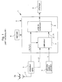
- the device 1 comprises a GPS receiver 3 receiving at a antenna 2 of radio waves 2a emitted by several satellites, a sensor altimeter pressure 4 calculating an altitude value as a function of a pressure measurement, a processing unit 5 receiving position data from the GPS receiver 3 and from altimeter 4 in order to process the data received in order to be able to display a position in X, Y and Z on a display means 9, and storage means 6 comprising cartographic data.
- a calibrator 7 for be able to calibrate the height provided by the altimeter in order to use this value of reference for subsequent position determination.
- the receiver GPS only calculates the data corresponding to positions X and Y, and therefore to pass from a three-dimensional mode to a two-dimensional mode.
- a disadvantage of such a device which is intended to equip a vehicle in the purpose of giving navigation information basically lies in the fact that it consumes a lot of electrical energy.
- this device can be powered by the vehicle battery without affecting its supply energy to other electrical parts of the vehicle.
- such a device does not cannot be used in a low power device such as a phone wearable or wrist watch.
- An object which the object of the invention proposes to resolve consists of a device for determining the horizontal and vertical positions in which a altimeter with pressure sensor calibrated at a predetermined initial height for the height measurement is used in combination with data provided by the GPS receiver in order to overcome the drawbacks of the devices of the prior art.
- Another object which the object of the invention proposes to resolve consists in a method of determining horizontal and vertical positions for actuation of said device.
- Another object which the object of the invention proposes to resolve consists in a use of the device to be able to assess weather forecasts.
- the processing unit sends a signal to the GPS receiver corresponding to the height value of the altimeter calibrated to allow means of calculation of the receiver to determine, using the height value, the device position data.
- the method for the activation of the device which is characterized in that it comprises the stages of calibrate the pressure sensor altimeter to a predetermined initial height using of data processed and supplied by the processing unit, transmit a value of height of the altimeter calibrated to the processing unit, send a corresponding signal to the height value of the calibrated altimeter from the processing unit to the receiver GPS to allow the receiver to determine, using the height value, the position data as a function of radio waves received from several satellites, and transmit the position data calculated by the receiver to the unit of processing so that they are processed and displayed on display means.
- the pressure sensor altimeter calibrated at a predetermined initial height is arranged to provide, at a height equivalent to a height stored in a previous time period, pressure changes converted to changes in height transmitted to the processing unit to determine conditions weather to display.
- An advantage of the device for determining the horizontal and vertical according to the invention resides in that it consumes little electrical energy thanks in particular to the reduction of the computation time in the GPS receiver with the data precise altitude supplied, in a return loop, by the processing unit on the base the precise height value from the calibrated altimeter, and using Low power microprocessors such as 8-bit microprocessors.
- the receiver will be able to do fewer iterations in the calculation operations to converge more quickly to the data of positions to be provided to the processing unit.
- the calculation error gives an incorrect result which can be much higher than inherent inaccuracy in GPS receiver devices, such as an error greater than ⁇ 150m for a vertical position.
- the low consumption of electrical energy thus makes it possible to envisage a integration of all the elements of the device, powered by a battery or a accumulator for low currents, in a timepiece, such as a wristwatch, or even in a small device, such as a phone portable.
- Another advantage of the device according to the invention consists in that it can be used to give weather conditions thanks to the altimeter with sensor of pressure.
- the variations of the altimeter sensor are used to define weather conditions for the day. If the altimeter reads + 50m by example, it means low pressure, on the other hand if it indicates -50m, it means high pressure.
- the altimeter sensor needs to be recalibrated at an precise predetermined height to serve, as previously described, for receiver calculation operations.
- FIG. 2 schematically represents the portable device 10 for the determination of horizontal and vertical positions, i.e. along the X, Y and Z.
- Horizontal positions are generally defined by longitude and latitude, and the vertical position is defined by the height above sea level.
- the portable device can be incorporated as well in a wristwatch with electronic timepiece, phone or other device electronic on a human scale which is easy to transport.
- the device is powered by a battery or accumulator for low currents of the watch, phone or device.
- the device comprises a GPS receiver 12 which receives at an antenna 11 radio waves from several satellites 20, storage means 13 of cartographic data associated in this case with the GPS receiver 12, a altimeter with pressure sensor 15 intended to measure pressure variations converted into a height value, a processing unit 14 receiving information to be processed from the receiver and the altimeter, and display means 16 for display at least the horizontal and vertical positions processed by the processing unit.
- the device 10 is incorporated in a wristwatch with analog or digital display
- all the components mentioned above are in principle fixed on a common support which is a printed circuit with metallic tracks connecting each component produced on one or two faces of an insulating substrate and connecting the battery for power supply.
- the support carrying all components is housed in the watch case leaving at least one opening towards the outside for pressure measurement by the altimeter sensor.
- Three satellites are sufficient to precisely determine the horizontal positions and vertical of the device provided that the clock of the receiver 12 is synchronized to that of the atomic clocks of said satellites. Otherwise, it is the receiver must be connected to at least four satellites, the fourth allowing the updating of the time base of the receiver, that is to say the synchronization of its internal clock.
- the determination of the position is relative to the determination of the intervals of time between radio signals received by the receiver of each of the four satellites questioned who each emitted at the same time their specific message with their ephemeris (GOLD code).
- the reception time of each radio signal therefore determines the distance from the reception point to the corresponding satellite since the code received from each of the satellites contains information about its position in orbit.
- the time taken by the signal from the satellite to the receiver multiplied by the speed of light gives the distance between the receiver and the satellite, which allows using the four satellites to deduce the position of the device in relation to so-called satellites.
- the altimeter 15 of the device 10 must be calibrated precisely at a predetermined height h in order to be able to base it on the value of precise height given by the altimeter especially for the operations of calculating the receiver when using the device as will be explained more detailed below with reference to Figure 3.
- the pressure sensor used in the altimeter 15 can be a piezoresistive sensor of known type made on a micro-machined silicon element having a membrane one side of which is exposed to ambient pressure and the other side of which carries resistors arranged in Wheatstone bridge. Any variation in pressure creates a unbalance of the bridge giving a voltage variation between the output terminals of said bridge.
- the sensor can be of the AM761 type which is marketed by the company Intersema Sensoric in Bevaix, Switzerland.
- the altimeter with pressure sensor When starting a hike, the altimeter with pressure sensor is therefore calibrated to a predetermined height which usually comes from the receiver GPS 12 in combination with precise cartographic data of a region of use of the device recorded for example in a memory 13.
- the height precise known from the starting location taken for example from memory 13 is brought to the processing unit 14 which returns it to the altimeter with pressure sensor 15 for a calibration operation.
- a comparison is normally made between the position data calculated by the GPS receiver and the precise data of several points of reference of a geographic map recorded in said memory. If the position horizontal (X, Y) or the horizontal and vertical positions (X, Y, Z) correspond to a precise data recorded, then at least the precise value of the height drawn memory is transmitted to the unit for the altimeter calibration.
- the memory 13 used in association with the GPS receiver 12 is by example EEPROM memory.
- EEPROM memory In this memory, it is possible to program electrically map data of a specific region in order to have in said memory precise values in X, Y and Z of a starting place or during a getaway, or also contour lines. Usually this is the given in Z which is communicated to the processing unit 14 by the receiver 12 of a specific location.
- calibrating the altimeter at a predetermined height can also be carried out in any other way than that described above, for example in entering the height value using a keyboard or by downloading directly in the processing unit.
- altimeter 15 is intended to make pressure measurements converted into height data relating to the predetermined height following the calibration during the hike and depending on weather conditions, i.e. during a period, for example 5 to 6 hours, when said conditions do not not vary too much.
- weather conditions i.e. during a period, for example 5 to 6 hours
- altitude difference i.e. for a change of 10 hectoPascal in change pressure corresponds to an altitude difference of 100m.
- the precise height value h of the calibrated altimeter 15 is transmitted to the unit 14 which sends a signal corresponding to this precise height value to the GPS 12 receiver in order to facilitate the data calculation operations horizontal and vertical as explained above. Taking into account the height of the altimeter 15 therefore makes it possible to reduce the iterations of the receiver for the calculation position values X, Y (longitude and latitude) and Z.
- the device 10 can provide on display means and on request, for example by pressing a button dedicated device control, or automatically at regular intervals, the value of the altitude Z, or h of the altimeter, and of the position in X and Y (longitude and latitude) by the data from the receiver 12 supplied to the processing unit 14.
- the signals transmitted to the processing 14 from GPS receiver 12 and altimeter15 include also parameters or quality factor of the data transmitted.
- DOPG quality parameters called DOPG defining a generalized reduction in precision are transmitted at the same time as position data (X, Y, Z). These parameters are also taken from signals received from satellites 20 where they can be broken down for example into HDOP for the horizontal position and in VDOP for the vertical position. These parameters allow the processing unit to know how accurate the position data calculated by the receiver. If this factor is 20, this means that the accuracy is poor, however if this factor approaches 1, this means that the accuracy is good. The processing unit transmits this data additional to display on the display means 16 to warn the user of the the quality of the measurement carried out.
- the quality factor QUAL is transmitted at the same time than the height value h at the processing unit.
- This factor can be for example representative of the height accuracy provided by the altimeter as a function of time flowing since the previous calibration of the pressure sensor of said altimeter 15. It has a value of 1 just after calibration and decreases almost linearly as function of the time which passes in a period of 5 to 6 hours as indicated above.
- the unit of treatment may decide whether to recalibrate the sensor so that it can subsequently provide a height value based on a new height predetermined at the GPS receiver for all subsequent calculation operations positions.
- the horizontal accuracy will always remain within ⁇ 100m even if the height is very precise.
- the time taken to calculate the receiver is greatly reduced, resulting in limited consumption of the receiver.
- X, Y positions calculated by the GPS 12 receiver, as well as the precise height value can be recorded in memory 13 to increase the number of place reference points listed.
- the device 10 can also be used to evaluate forecasts weather. At the same known and recorded altitude, any variation in pressure of altimeter 15 pressure sensor relative to a pressure value from a previous calibration may reflect barometric trends.
- the unit of processing in this case, will take the height value transmitted by the altimeter and the compare with a previous value recorded at the same altitude.
- This information processed by the processing unit can be displayed by the device to give an indication of the weather conditions to his user before going on a hike and before having to calibrate again the altimeter to a precise height memorized.
- EP 0 670 532 From the applicant describing a weather watch.
- a climatic variation is measured between 0.6 to 1.6 mbar / h between a low and a strong climatic disturbance, while the measurement of a variation in altitude is around 30 mbar / h for a height of 300 m which can be much higher than climatic variation during a hike.
- the height given by the altimeter can be considered as precise even with a slight influence of climatic variation.
- climatic variations can be controlled by the unit for the weather forecast for the coming day.
- FIG 3 shows in more detail the electronic blocks of the GPS receiver associated with storage means, such as a memory EEPROM 13 described previously with reference to Figure 2.
- Said receiver comprises an antenna 11 for receiving the radio signals to carrier frequency of 1.57542 GHz from several satellites 20, a first radio frequency conversion circuit 21 receiving the signals 31 from the antenna 11 for operate the signal frequency 31 to provide signals 32 at a frequency of the order of 180 MHz, a second conversion circuit 22 receiving the signals 32 to operate a reduction in the frequency of the signals 32 to supply signals 33 at a frequency of the order of 4 MHz, a correlator 23 receiving signals 33 and comprising a series of reduction stages for ability to derive radio codes received from the antenna specific codes for each satellite, an 8-bit microcontroller 24 in communication with the correlator 23 by the lines 34 to receive information from said correlator and impose orders.
- the data transmitted by the lines 34 of the correlator 23 to the microcontroller 24 are normally at a frequency of 50 Hz, while the microcontroller works with a clock signal of the order of 8 MHz and also allows the synchronization of the correlator 23. As described above, this time base must be synchronized with the time base of the satellites.
- the first radio frequency conversion circuit 21 consumes more of electrical energy than the other components of said receiver, it is only engaged for the reception of each radio signal and the transmission to the second circuit of conversion.
- Each specific satellite code modulated on the carrier frequency of 1.57542 GHz is called the Gold code.
- This code is a code at a frequency of 1.023MHz (1023 bits) which repeats every milliseconds (1ms).
- the microcontroller 24 also controls the correlator 23 to impose it to connect according to such a channel on such or such satellite insofar as a communication can take place. If a satellite on demand from the microcontroller cannot be reached within a period of time the microcontroller 24 gives another order to the correlator 23 to be able to connect to another of the available satellites. More the greater the number of satellites questioned, the greater the precision, but four satellites at least are essential.
- the 8-bit microcontroller can be the one sold under the name CooIRISC-816 from EM Microelectronic-Marin SA in Switzerland.
- the input and output block 41 receives the position data (X, Y, Z) of the GPS receiver, DOPG quality parameters of position data, value height h of the altimeter and the quality factor QUAL of the altimeter.
- a comparison circuit can be provided in particular between the DOPG quality parameters and the QUAL quality factor as described above.
- the RAM memory 46 it can be stored for example values of height received from the calibrated altimeter or receiver so that it can also be used the weather forecast to display.
- the microprocessor is advantageously an 8-bit PUNCH microprocessor supplied by EM Microelectronic-Marin SA in Switzerland.
Priority Applications (9)
| Application Number | Priority Date | Filing Date | Title |
|---|---|---|---|
| EP00201021A EP1136788A1 (de) | 2000-03-22 | 2000-03-22 | Tragbares GPS-Gerät, welches einen barometrischen Höhemesser verwendet |
| JP2001569223A JP2004500573A (ja) | 2000-03-22 | 2001-02-20 | 水平位置と垂直位置を決定する携帯装置およびそれを動作させるための方法 |
| AT01903784T ATE297008T1 (de) | 2000-03-22 | 2001-02-20 | Tragbarer gps-empfänger, welcher einen barometrischen höhenmesser verwendet |
| DE60111206T DE60111206T2 (de) | 2000-03-22 | 2001-02-20 | Tragbarer gps-empfänger, welcher einen barometrischen höhenmesser verwendet |
| EP01903784A EP1269116B1 (de) | 2000-03-22 | 2001-02-20 | Tragbarer gps-empfänger, welcher einen barometrischen höhenmesser verwendet |
| PCT/EP2001/001891 WO2001071281A1 (fr) | 2000-03-22 | 2001-02-20 | Recepteur gps portable utilisant un altimetre barometrique |
| CNB018069630A CN1325876C (zh) | 2000-03-22 | 2001-02-20 | 用于确定水平和竖直位置的便携设备及操作该设备的方法 |
| US10/245,124 US6882308B2 (en) | 2000-03-22 | 2002-09-17 | Portable device for determining horizontal and vertical positions and method for operating the same |
| HK03108827A HK1056391A1 (en) | 2000-03-22 | 2003-12-03 | Portable gps receiver using a barometric altimeter |
Applications Claiming Priority (1)
| Application Number | Priority Date | Filing Date | Title |
|---|---|---|---|
| EP00201021A EP1136788A1 (de) | 2000-03-22 | 2000-03-22 | Tragbares GPS-Gerät, welches einen barometrischen Höhemesser verwendet |
Publications (1)
| Publication Number | Publication Date |
|---|---|
| EP1136788A1 true EP1136788A1 (de) | 2001-09-26 |
Family
ID=8171232
Family Applications (2)
| Application Number | Title | Priority Date | Filing Date |
|---|---|---|---|
| EP00201021A Withdrawn EP1136788A1 (de) | 2000-03-22 | 2000-03-22 | Tragbares GPS-Gerät, welches einen barometrischen Höhemesser verwendet |
| EP01903784A Expired - Lifetime EP1269116B1 (de) | 2000-03-22 | 2001-02-20 | Tragbarer gps-empfänger, welcher einen barometrischen höhenmesser verwendet |
Family Applications After (1)
| Application Number | Title | Priority Date | Filing Date |
|---|---|---|---|
| EP01903784A Expired - Lifetime EP1269116B1 (de) | 2000-03-22 | 2001-02-20 | Tragbarer gps-empfänger, welcher einen barometrischen höhenmesser verwendet |
Country Status (8)
| Country | Link |
|---|---|
| US (1) | US6882308B2 (de) |
| EP (2) | EP1136788A1 (de) |
| JP (1) | JP2004500573A (de) |
| CN (1) | CN1325876C (de) |
| AT (1) | ATE297008T1 (de) |
| DE (1) | DE60111206T2 (de) |
| HK (1) | HK1056391A1 (de) |
| WO (1) | WO2001071281A1 (de) |
Cited By (3)
| Publication number | Priority date | Publication date | Assignee | Title |
|---|---|---|---|---|
| WO2004003472A1 (en) * | 2002-07-01 | 2004-01-08 | Nokia Corporation | Mobile communication terminal |
| WO2009153212A1 (fr) * | 2008-06-16 | 2009-12-23 | Em Microelectronic-Marin Sa | Instrument de calibration d'un dispositif altimetrique |
| EP2574962A3 (de) * | 2011-09-30 | 2015-05-20 | Maishi Electronic (Shanghai) Ltd. | Anordnung zur Bestimmung von Bewegungs-Information, Empfänger und Verfahren dazu |
Families Citing this family (43)
| Publication number | Priority date | Publication date | Assignee | Title |
|---|---|---|---|---|
| FR2815501B1 (fr) * | 2000-10-13 | 2004-07-02 | Sagem | Perfectionnements aux terminaux mobiles de telecommunication |
| US6522298B1 (en) * | 2001-04-12 | 2003-02-18 | Garmin Ltd. | Device and method for calibrating and improving the accuracy of barometric altimeters with GPS-derived altitudes |
| US10185455B2 (en) | 2012-10-04 | 2019-01-22 | Zonar Systems, Inc. | Mobile computing device for fleet telematics |
| US9563869B2 (en) | 2010-09-14 | 2017-02-07 | Zonar Systems, Inc. | Automatic incorporation of vehicle data into documents captured at a vehicle using a mobile computing device |
| US7353139B1 (en) * | 2002-12-13 | 2008-04-01 | Garmin Ltd. | Portable apparatus with performance monitoring and audio entertainment features |
| US7035733B1 (en) | 2003-09-22 | 2006-04-25 | Navteq North America, Llc | Method and system for obtaining road grade data |
| US7305303B2 (en) * | 2004-03-02 | 2007-12-04 | Honeywell International Inc. | Personal navigation using terrain-correlation and/or signal-of-opportunity information |
| US7706977B2 (en) * | 2004-10-26 | 2010-04-27 | Honeywell International Inc. | Personal navigation device for use with portable device |
| US20070282565A1 (en) * | 2006-06-06 | 2007-12-06 | Honeywell International Inc. | Object locating in restricted environments using personal navigation |
| US20130164715A1 (en) | 2011-12-24 | 2013-06-27 | Zonar Systems, Inc. | Using social networking to improve driver performance based on industry sharing of driver performance data |
| US20130164713A1 (en) | 2011-12-23 | 2013-06-27 | Zonar Systems, Inc. | Method and apparatus for gps based slope determination, real-time vehicle mass determination, and vehicle efficiency analysis |
| US10056008B1 (en) | 2006-06-20 | 2018-08-21 | Zonar Systems, Inc. | Using telematics data including position data and vehicle analytics to train drivers to improve efficiency of vehicle use |
| DE102006037674A1 (de) * | 2006-08-11 | 2008-02-14 | Töteberg, Andreas | System zur Höhenortung |
| EP1980867A3 (de) * | 2007-04-10 | 2009-11-25 | Qualcomm Incorporated | Mehrwegkompensation unter Verwendung von Sensoren |
| WO2008148785A1 (en) * | 2007-06-08 | 2008-12-11 | Qualcomm Incorporated | Satellite radiolocalization receiver |
| US20080303663A1 (en) * | 2007-06-08 | 2008-12-11 | Nemerix Sa | Method for verifying the integrity of a container |
| WO2008148794A2 (en) * | 2007-06-08 | 2008-12-11 | Qualcomm Incorporated | Gnss positioning using pressure sensors |
| US8332137B2 (en) * | 2007-12-04 | 2012-12-11 | Qualcomm Incorporated | Navigation system with dynamically calibrated pressure sensor |
| US20110205115A1 (en) * | 2008-02-25 | 2011-08-25 | Sirf Technology, Inc. | Always on GPS Device |
| US8188917B2 (en) * | 2008-02-25 | 2012-05-29 | CSR Technology Holdings Inc. | System and method for operating a GPS device in a micro power mode |
| CN101280681B (zh) * | 2008-05-29 | 2012-04-04 | 北京金禾创业科技发展有限公司 | 采用gps定位技术的油井憋压试验记录仪 |
| IT1396970B1 (it) * | 2008-10-21 | 2012-12-20 | Venturi | Dispositivo portatile di soccorso. |
| JP4892695B2 (ja) * | 2009-01-16 | 2012-03-07 | 防衛省技術研究本部長 | キネマティックgpsを活用した計器校正飛行試験方法 |
| WO2011026530A1 (en) * | 2009-09-07 | 2011-03-10 | Tomtom International B.V. | Navigation apparatus and method of supporting hands-free voice communication |
| US20110199257A1 (en) * | 2010-02-18 | 2011-08-18 | David Lundgren | Method and system for updating altitude information for a location by using terrain model information to prime altitude sensors |
| CN102445700A (zh) * | 2010-10-14 | 2012-05-09 | 环达电脑(上海)有限公司 | Nmea信息的gps高度数据修正系统及方法 |
| US9527515B2 (en) | 2011-12-23 | 2016-12-27 | Zonar Systems, Inc. | Vehicle performance based on analysis of drive data |
| US10431020B2 (en) | 2010-12-02 | 2019-10-01 | Zonar Systems, Inc. | Method and apparatus for implementing a vehicle inspection waiver program |
| JP5652418B2 (ja) * | 2012-03-27 | 2015-01-14 | カシオ計算機株式会社 | 高度情報取得装置、及び、高度情報取得システム |
| US20130261939A1 (en) | 2012-04-01 | 2013-10-03 | Zonar Systems, Inc. | Method and apparatus for matching vehicle ecu programming to current vehicle operating conditions |
| US9599632B2 (en) * | 2012-06-22 | 2017-03-21 | Fitbit, Inc. | Fitness monitoring device with altimeter |
| US9424696B2 (en) | 2012-10-04 | 2016-08-23 | Zonar Systems, Inc. | Virtual trainer for in vehicle driver coaching and to collect metrics to improve driver performance |
| CN102910254A (zh) * | 2012-11-09 | 2013-02-06 | 江苏吉信远望船舶设备有限公司 | 便携式水尺画线装置 |
| KR101851836B1 (ko) * | 2012-12-03 | 2018-04-24 | 나비센스, 인크. | 물체의 움직임을 추정하기 위한 시스템 및 방법 |
| JP2016515210A (ja) * | 2013-03-15 | 2016-05-26 | ローベルト ボツシユ ゲゼルシヤフト ミツト ベシユレンクテル ハフツングRobert Bosch Gmbh | 屋内ナビゲーション支援用の分散型気圧計ネットワーク |
| US9521508B2 (en) | 2013-06-19 | 2016-12-13 | Blackberry Limited | Architecture and method to 4G-mobile positioning |
| US20150133171A1 (en) * | 2013-11-12 | 2015-05-14 | Blackberry Limited | Method and system for implementing a dual-mode dual-band gnss/m-lms pseudolites receiver |
| US9507010B2 (en) | 2013-12-20 | 2016-11-29 | Blackberry Limited | Method for improving clock accuracy in a wide area positioning pseudolite receiver system architecture |
| WO2016054390A1 (en) * | 2014-10-01 | 2016-04-07 | Intel Corporation | Methods and systems for vertical trajectory determination |
| DE102014115913A1 (de) * | 2014-10-31 | 2016-05-04 | Deutsche Telekom Ag | Verfahren und mobiles Endgerät zur Höhenmessung |
| US9952354B2 (en) | 2015-09-11 | 2018-04-24 | At&T Intellectual Property I, L.P. | User equipment local barometric calibration |
| JP6829108B2 (ja) * | 2017-02-24 | 2021-02-10 | セイコーインスツル株式会社 | 高度計、及び高度検出方法 |
| EP3598178A1 (de) * | 2018-07-20 | 2020-01-22 | Trimble Nantes S.A.S. | Tragbare positionierungsvorrichtungen und verfahren zum erhalt einer geospatialen position |
Citations (5)
| Publication number | Priority date | Publication date | Assignee | Title |
|---|---|---|---|---|
| US5210540A (en) * | 1991-06-18 | 1993-05-11 | Pioneer Electronic Corporation | Global positioning system |
| EP0670532A1 (de) * | 1994-03-04 | 1995-09-06 | Asulab S.A. | Uhr mit Wettervorhersage |
| JPH09145814A (ja) * | 1995-11-21 | 1997-06-06 | Harada Ind Co Ltd | 携帯形gps測位表示装置 |
| US5646857A (en) * | 1995-03-31 | 1997-07-08 | Trimble Navigation Limited | Use of an altitude sensor to augment availability of GPS location fixes |
| JPH11166827A (ja) * | 1997-10-01 | 1999-06-22 | Seiko Instruments Inc | 携帯型高度計およびgps受信装置の電源供給制御方法 |
Family Cites Families (18)
| Publication number | Priority date | Publication date | Assignee | Title |
|---|---|---|---|---|
| JPH071174B2 (ja) * | 1986-07-18 | 1995-01-11 | 日本無線株式会社 | Gps受信機の高度補正方式 |
| JP2859277B2 (ja) * | 1988-12-16 | 1999-02-17 | シチズン時計株式会社 | 高度測定装置 |
| US4977509A (en) * | 1988-12-09 | 1990-12-11 | Campsport, Inc. | Personal multi-purpose navigational apparatus and method for operation thereof |
| JPH0470584A (ja) * | 1990-07-11 | 1992-03-05 | Mitsubishi Electric Corp | 衛星航法装置 |
| JPH04134281A (ja) * | 1990-09-26 | 1992-05-08 | Aisin Seiki Co Ltd | 移動体位置表示装置 |
| JPH04204281A (ja) * | 1990-11-30 | 1992-07-24 | Toshiba Corp | Gpsを用いた現在位置表示装置 |
| JPH0627215A (ja) * | 1992-07-08 | 1994-02-04 | Matsushita Electric Ind Co Ltd | 携帯型gps受信機 |
| CN1155663A (zh) * | 1995-05-30 | 1997-07-30 | 休斯电子公司 | 利用现成的全球定位系统的数字式蜂窝电话 |
| US6133874A (en) * | 1996-03-08 | 2000-10-17 | Snaptrack, Inc. | Method and apparatus for acquiring satellite positioning system signals |
| CH691337A5 (de) * | 1996-06-10 | 2001-06-29 | Asulab Sa | Tragbare Präzisionsuhr mit Zusatzfunktionen. |
| US5890090A (en) * | 1996-11-20 | 1999-03-30 | Trimble Navigation Limited | Half-dead-reckoning capable GPS navigation receiver |
| US5949812A (en) * | 1996-12-12 | 1999-09-07 | Trimble Navigation Limited | Method and system for conserving battery reserves in a navigation receiver by slowing and/or stopping the system clock during low demand |
| US6016606A (en) * | 1997-04-25 | 2000-01-25 | Navitrak International Corporation | Navigation device having a viewer for superimposing bearing, GPS position and indexed map information |
| US5977909A (en) * | 1998-03-13 | 1999-11-02 | General Electric Company | Method and apparatus for locating an object using reduced number of GPS satellite signals or with improved accuracy |
| US6061018A (en) * | 1998-05-05 | 2000-05-09 | Snaptrack, Inc. | Method and system for using altitude information in a satellite positioning system |
| US6205377B1 (en) * | 1999-04-27 | 2001-03-20 | Trimble Navigation Ltd | Method for navigation of moving platform by using satellite data supplemented by satellite-calibrated baro data |
| US6529827B1 (en) * | 1999-11-01 | 2003-03-04 | Garmin Corporation | GPS device with compass and altimeter and method for displaying navigation information |
| US6552681B1 (en) * | 2000-10-02 | 2003-04-22 | Skynetix, Llc | Method for determining vertical and horizontal GPS position using altitude information |
-
2000
- 2000-03-22 EP EP00201021A patent/EP1136788A1/de not_active Withdrawn
-
2001
- 2001-02-20 WO PCT/EP2001/001891 patent/WO2001071281A1/fr active IP Right Grant
- 2001-02-20 EP EP01903784A patent/EP1269116B1/de not_active Expired - Lifetime
- 2001-02-20 JP JP2001569223A patent/JP2004500573A/ja active Pending
- 2001-02-20 CN CNB018069630A patent/CN1325876C/zh not_active Expired - Fee Related
- 2001-02-20 DE DE60111206T patent/DE60111206T2/de not_active Expired - Lifetime
- 2001-02-20 AT AT01903784T patent/ATE297008T1/de not_active IP Right Cessation
-
2002
- 2002-09-17 US US10/245,124 patent/US6882308B2/en not_active Expired - Lifetime
-
2003
- 2003-12-03 HK HK03108827A patent/HK1056391A1/xx not_active IP Right Cessation
Patent Citations (5)
| Publication number | Priority date | Publication date | Assignee | Title |
|---|---|---|---|---|
| US5210540A (en) * | 1991-06-18 | 1993-05-11 | Pioneer Electronic Corporation | Global positioning system |
| EP0670532A1 (de) * | 1994-03-04 | 1995-09-06 | Asulab S.A. | Uhr mit Wettervorhersage |
| US5646857A (en) * | 1995-03-31 | 1997-07-08 | Trimble Navigation Limited | Use of an altitude sensor to augment availability of GPS location fixes |
| JPH09145814A (ja) * | 1995-11-21 | 1997-06-06 | Harada Ind Co Ltd | 携帯形gps測位表示装置 |
| JPH11166827A (ja) * | 1997-10-01 | 1999-06-22 | Seiko Instruments Inc | 携帯型高度計およびgps受信装置の電源供給制御方法 |
Non-Patent Citations (2)
| Title |
|---|
| PATENT ABSTRACTS OF JAPAN vol. 1997, no. 10 31 October 1997 (1997-10-31) * |
| PATENT ABSTRACTS OF JAPAN vol. 1999, no. 11 30 September 1999 (1999-09-30) * |
Cited By (5)
| Publication number | Priority date | Publication date | Assignee | Title |
|---|---|---|---|---|
| WO2004003472A1 (en) * | 2002-07-01 | 2004-01-08 | Nokia Corporation | Mobile communication terminal |
| US7263442B2 (en) | 2002-07-01 | 2007-08-28 | Nokia Corporation | Mobile communication terminal |
| WO2009153212A1 (fr) * | 2008-06-16 | 2009-12-23 | Em Microelectronic-Marin Sa | Instrument de calibration d'un dispositif altimetrique |
| EP2136179A1 (de) * | 2008-06-16 | 2009-12-23 | EM Microelectronic-Marin SA | Gerät zur Eichung einer Höhenmessvorrichtung |
| EP2574962A3 (de) * | 2011-09-30 | 2015-05-20 | Maishi Electronic (Shanghai) Ltd. | Anordnung zur Bestimmung von Bewegungs-Information, Empfänger und Verfahren dazu |
Also Published As
| Publication number | Publication date |
|---|---|
| CN1325876C (zh) | 2007-07-11 |
| DE60111206T2 (de) | 2006-04-27 |
| ATE297008T1 (de) | 2005-06-15 |
| DE60111206D1 (de) | 2005-07-07 |
| EP1269116B1 (de) | 2005-06-01 |
| WO2001071281A1 (fr) | 2001-09-27 |
| JP2004500573A (ja) | 2004-01-08 |
| HK1056391A1 (en) | 2004-02-13 |
| CN1426528A (zh) | 2003-06-25 |
| US6882308B2 (en) | 2005-04-19 |
| EP1269116A1 (de) | 2003-01-02 |
| US20040054470A1 (en) | 2004-03-18 |
Similar Documents
| Publication | Publication Date | Title |
|---|---|---|
| EP1269116B1 (de) | Tragbarer gps-empfänger, welcher einen barometrischen höhenmesser verwendet | |
| EP1839070B1 (de) | Satellitenortungsempfänger mit verbesserter integrität und kontinuität | |
| CA2461595C (fr) | Centrale de navigation inertielle hybride a integrite amelioree | |
| EP1724604B1 (de) | Vorrichtung und Verfahren um die Position mit einem GPS-Empfänger und einem Kompass zu bestimmen | |
| EP0875002B1 (de) | Flugzeugsteuerhilfssystem mit head-up anzeigevorrichtung | |
| US8188916B2 (en) | Position/time detecting apparatus and timepiece including the apparatus | |
| EP1466139B1 (de) | Hybride trägheitsnavigationszentrale mit verbesserter höhenintegrität | |
| EP1503220A2 (de) | Positionsbestimmung einer Mobilendgerät mittels auf Anfrage gesendeten Hilfsdaten | |
| WO2005096106A1 (fr) | Dispositif électronique portable avec fonction variomètre à affichage analogique | |
| EP3379347B1 (de) | Verfahren zur regulierung der gangfrequenz einer elektronischen uhr | |
| FR3023922A1 (fr) | Recepteur de positionnement et de navigation a indicateur de confiance | |
| FR2892193A1 (fr) | Dispositif et procede de correction des effets du vieillissement d'un capteur de mesure | |
| FR2858510A1 (fr) | Determination de positions de terminaux mobiles a l'aide de donnees d'assistance transmises sur requete | |
| JP5657564B2 (ja) | イベント位置の決定 | |
| CH686469B5 (fr) | Pièce d'horlogerie permettant de faire le point. | |
| EP2291607B1 (de) | Gerät zur eichung einer höhenmessvorrichtung | |
| EP1462885A1 (de) | Driftkompensationsverfahren für eine Uhr in einem Kraftfahrzeug | |
| CN114252894A (zh) | 信息处理装置、定位方法以及存储介质 | |
| EP2068168A1 (de) | Verfahren zur Positionsbestimmung eines Low-Power-Funksignalempfängers | |
| EP2265045A1 (de) | Elektronische Einheit und Mikrochip-Karte für elektronische Einheit | |
| JP2010217004A (ja) | 電子機器および電子機器の制御方法 | |
| JP6992360B2 (ja) | 位置計測装置、電子時計、位置補正方法及びプログラム | |
| KR100723198B1 (ko) | 네비게이션 메시지의 업데이트 방법 | |
| EP1223675A1 (de) | Verfahren und Vorrichtung zum Kompensieren von durch einen Referenztaktgenerator hervorgerufenen Messfehlern | |
| CH698599B1 (fr) | Dispositif électronique portable à récepteur de signaux radiofréquences, et procédé de détermination de position d'un tel dispositif. |
Legal Events
| Date | Code | Title | Description |
|---|---|---|---|
| PUAI | Public reference made under article 153(3) epc to a published international application that has entered the european phase |
Free format text: ORIGINAL CODE: 0009012 |
|
| AK | Designated contracting states |
Kind code of ref document: A1 Designated state(s): AT BE CH CY DE DK ES FI FR GB GR IE IT LI LU MC NL PT SE |
|
| AX | Request for extension of the european patent |
Free format text: AL;LT;LV;MK;RO;SI |
|
| STAA | Information on the status of an ep patent application or granted ep patent |
Free format text: STATUS: THE APPLICATION HAS BEEN WITHDRAWN |
|
| 18W | Application withdrawn |
Withdrawal date: 20020118 |