EP1102399A2 - Verfahren und Vorrichtung zur Filterung von Messungen in einem verallgemeinerten Positionierungssystem - Google Patents
Verfahren und Vorrichtung zur Filterung von Messungen in einem verallgemeinerten Positionierungssystem Download PDFInfo
- Publication number
- EP1102399A2 EP1102399A2 EP00309542A EP00309542A EP1102399A2 EP 1102399 A2 EP1102399 A2 EP 1102399A2 EP 00309542 A EP00309542 A EP 00309542A EP 00309542 A EP00309542 A EP 00309542A EP 1102399 A2 EP1102399 A2 EP 1102399A2
- Authority
- EP
- European Patent Office
- Prior art keywords
- measurement
- state
- measurements
- filter
- positioning system
- Prior art date
- Legal status (The legal status is an assumption and is not a legal conclusion. Google has not performed a legal analysis and makes no representation as to the accuracy of the status listed.)
- Withdrawn
Links
- 238000005259 measurement Methods 0.000 title claims abstract description 203
- 238000000034 method Methods 0.000 title claims description 43
- 238000001914 filtration Methods 0.000 title claims description 14
- 230000001413 cellular effect Effects 0.000 claims abstract description 36
- 238000010200 validation analysis Methods 0.000 claims abstract description 24
- 238000004891 communication Methods 0.000 claims description 11
- 238000009826 distribution Methods 0.000 claims description 7
- 238000001514 detection method Methods 0.000 claims description 4
- 230000001419 dependent effect Effects 0.000 claims 1
- 230000004043 responsiveness Effects 0.000 abstract description 3
- 238000004364 calculation method Methods 0.000 abstract 1
- 230000008569 process Effects 0.000 description 31
- 239000011159 matrix material Substances 0.000 description 10
- 239000013598 vector Substances 0.000 description 10
- 238000010586 diagram Methods 0.000 description 9
- 101000802640 Homo sapiens Lactosylceramide 4-alpha-galactosyltransferase Proteins 0.000 description 6
- 102100035838 Lactosylceramide 4-alpha-galactosyltransferase Human genes 0.000 description 6
- 238000013459 approach Methods 0.000 description 2
- 230000001143 conditioned effect Effects 0.000 description 2
- 238000012986 modification Methods 0.000 description 2
- 230000004048 modification Effects 0.000 description 2
- 230000001133 acceleration Effects 0.000 description 1
- 230000008859 change Effects 0.000 description 1
- 238000010276 construction Methods 0.000 description 1
- 230000007123 defense Effects 0.000 description 1
- 230000000694 effects Effects 0.000 description 1
- 230000007613 environmental effect Effects 0.000 description 1
- 230000001771 impaired effect Effects 0.000 description 1
- 230000002452 interceptive effect Effects 0.000 description 1
- 230000007257 malfunction Effects 0.000 description 1
- 238000007781 pre-processing Methods 0.000 description 1
- 238000013139 quantization Methods 0.000 description 1
Images


Classifications
-
- G—PHYSICS
- G01—MEASURING; TESTING
- G01S—RADIO DIRECTION-FINDING; RADIO NAVIGATION; DETERMINING DISTANCE OR VELOCITY BY USE OF RADIO WAVES; LOCATING OR PRESENCE-DETECTING BY USE OF THE REFLECTION OR RERADIATION OF RADIO WAVES; ANALOGOUS ARRANGEMENTS USING OTHER WAVES
- G01S19/00—Satellite radio beacon positioning systems; Determining position, velocity or attitude using signals transmitted by such systems
- G01S19/38—Determining a navigation solution using signals transmitted by a satellite radio beacon positioning system
- G01S19/39—Determining a navigation solution using signals transmitted by a satellite radio beacon positioning system the satellite radio beacon positioning system transmitting time-stamped messages, e.g. GPS [Global Positioning System], GLONASS [Global Orbiting Navigation Satellite System] or GALILEO
-
- G—PHYSICS
- G01—MEASURING; TESTING
- G01S—RADIO DIRECTION-FINDING; RADIO NAVIGATION; DETERMINING DISTANCE OR VELOCITY BY USE OF RADIO WAVES; LOCATING OR PRESENCE-DETECTING BY USE OF THE REFLECTION OR RERADIATION OF RADIO WAVES; ANALOGOUS ARRANGEMENTS USING OTHER WAVES
- G01S19/00—Satellite radio beacon positioning systems; Determining position, velocity or attitude using signals transmitted by such systems
- G01S19/38—Determining a navigation solution using signals transmitted by a satellite radio beacon positioning system
- G01S19/39—Determining a navigation solution using signals transmitted by a satellite radio beacon positioning system the satellite radio beacon positioning system transmitting time-stamped messages, e.g. GPS [Global Positioning System], GLONASS [Global Orbiting Navigation Satellite System] or GALILEO
- G01S19/42—Determining position
- G01S19/45—Determining position by combining measurements of signals from the satellite radio beacon positioning system with a supplementary measurement
- G01S19/46—Determining position by combining measurements of signals from the satellite radio beacon positioning system with a supplementary measurement the supplementary measurement being of a radio-wave signal type
-
- H—ELECTRICITY
- H03—ELECTRONIC CIRCUITRY
- H03H—IMPEDANCE NETWORKS, e.g. RESONANT CIRCUITS; RESONATORS
- H03H17/00—Networks using digital techniques
- H03H17/02—Frequency selective networks
- H03H17/0248—Filters characterised by a particular frequency response or filtering method
- H03H17/0255—Filters based on statistics
- H03H17/0257—KALMAN filters
Definitions
- the present invention relates generally to positioning systems. More particularly, the present invention pertains to the application of a filter, such as the extended Kalman filter, in such positioning systems, or in systems that provide estimates of one or another aspect besides position of the motion of an object, using information acquired from cellular base stations and from satellites.
- a filter such as the extended Kalman filter
- a satellite positioning system (SATPS) receiver generally determines its positions by triangulating its Line of Sight (LOS) range to several satellites or space vehicles.
- LOS Line of Sight
- a GPS receiver for example, computes a 4-dimensional solution involving latitude, longitude, altitude, and time using the LOS ranges to as few as four satellites. The accuracy of the solution is a direct function of the accuracy of the range measurements.
- SATPS receivers are growing rapidly in popularity and application.
- GPS receivers for example, are now common in aviation, marine, and terrestrial applications.
- An increasingly common terrestrial application for GPS receivers is in automobiles.
- the vehicle's location is typically displayed on an electronic display of a street map. It is vital in this context, therefore, to provide the driver with continuously updated position solutions, collectively called a "ground track," that accurately track the vehicle's movement from one moment to the next.
- ground track collectively called a "ground track”
- consumers consider ground-track fidelity as one of the most important criteria in choosing a receiver. It is extremely important, therefore, that the ground-track displayed on the GPS receiver's electronic map not have spurious jumps, stair steps, spikes, jigs, or jogs that are unrelated to the vehicle's actual path.
- SA Selective Availability
- DOD Department of Defense
- multi-path Another common source of position solution discontinuity is due to the phenomenon known as multi-path, where the true LOS signal from a given satellite reaches the GPS receiver's antenna, along with additional signals providing supposedly the same information, the additional signals caused by reflection from nearby objects, such as buildings or cliffs.
- the multi-path phenomenon is particularly troublesome for automotive receivers because they are frequently used in cities and surrounded by tall buildings. This environment is sometimes called an "urban canyon” due to the canyon-like setting it resembles.
- multi-path can be a very vexing problem because the additional signals may be very strong, but very wrong.
- Yet another source of position solution discontinuity is that the constellation of satellites used by a SATPS receiver can change; the SATPS receiver may see a different constellation of satellites from one moment to the next. If the GPS receiver is located in an urban canyon environment, for example, individual satellites may become blocked and later unblocked as the receiver moves past different buildings. The discontinuity arises in this situation because the error in a position solution is based on the constellation of satellites used. (Two satellites located in approximately the same direction will provide position information with larger error than two satellites in very different directions, all other things being equal.) If the position solution provided by a GPS receiver is suddenly based on a different constellation, the different error may cause a jump or discontinuity in position.
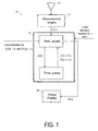
- Fig. 1 is a simplified flow diagram of a conventional GPS-type positioning system 10 including an RF antenna 11, a measurement engine 12 and a Kalman filter 14, providing a position estimate x and ( k ) for position at time instant k.
- the measurement engine 12 receives RF signals from a plurality of orbiting satellites via the antenna 11 and provides the Kalman filter 14 with measured position and velocity, i.e. measured state information as opposed to the predicted state information provided by the Kalman filter based on the measured values.
- the measurement engine 12 varies from application to application.
- the measurement engine 12 contains the analog electronics (e.g. preamplifiers, amplifiers, frequency converters, etc.) needed to pull in the RF signal, and further includes a code correlator for detecting a particular GPS code corresponding to a particular satellite.
- the measurement engine 12 estimates the line of sight (LOS) range to a detected satellite using a local, onboard GPS clock and data from the satellite indicating when the satellite code was transmitted.
- the LOS ranges determined this way are called pseudo-ranges because they are only estimates of the actual ranges, based on the local detection time.
- the measurement engine 12 converts the pseudo-ranges it acquires over time to measurements z(k) of the state of the process, i.e. to a position and velocity of the moving object whose position is being determined.
- a standard Kalman filter cannot be used, or at least not used without first deriving from information provided (by e.g. satellites) about the process measurement data that is, at least approximately, linearly related to the state of the process, and at least not without taking measurements at close enough intervals that the effects of any non-linearity in the evolution of the process does not become important from one measurement to the next.
- the satellite provides a pseudo-range: in which x i (k) is, e.g. the i th component of the three-dimensional position of the vehicle, x s / i is the same for the satellite, t o is a clock offset between the positioning system clock in the vehicle and the satellite clock, and c is used to designate the speed of light.
- This linearizing makes possible the use of a Kalman-type filter in estimating the state of a process, an approach that is recursive (the solution at a preceding instant, along with a current measurement, leading to the solution at the next instant), as compared with other approaches, such as iterative or direct solution, that rely on the current measurement (alone) for solution.
- What is further needed is a way for a positioning system to combine multiple such measurements, at any instant of time, so as to further increase the reliability of the positioning system.
- cellular base station data does not suffer from the same errors as affect satellite data
- a positioning system can be made more reliable if it uses both kinds of data separately and simultaneously, providing therefore at least two measurements at the same instant of time, one purely based on satellite data and one purely based on cellular data.
- the main sources of noise and inaccuracy in cellular data are not the same as for satellites; instead of atmosphere, multi-path, and selective availability, error in a cellular system is caused by obstacles in the signal path, range measurement quantization, and interfering frequencies.
- the present invention provides a filter for a generalized positioning system, and also a corresponding generalized positioning system and method. All of these are based on using information from cellular base stations, at least part of the time, in providing a succession of estimates of one or another aspect of the state of motion of an object, such as estimates of position or velocity or both.
- the generalized positioning system includes: a filter, responsive to an initial estimate of a state of motion of the object, and an initial value of state covariance, and further responsive to a succession of measurements of the state, each corresponding to a different instant of time, for statistically determining the succession of state estimates; and a measurement engine, responsive to information provided by cellular base stations, from which a measurement of the state can be determined, for providing the succession of measurements of the state.
- the filter is a non-linear filter, such as an extended Kalman filter, and in other aspects of the invention the filter is a linear filter.
- the generalized positioning system also includes: means for determining association probabilities for a plurality of state measurements all at a same instant of time, each association probability corresponding to a particular state measurement at the instant of time, and also means for determining an association probability providing a value for the probability that none of the plurality of measurements is correct; means for combining into a single measurement innovation each individual innovation using the association probabilities as weightings; and means for determining the covariance of the updated state based on the individual association probabilities, the association probability for providing a value for the probability that none of the measurements is correct, and the combined measurement innovation.
- the filter of the generalized positioning system is responsive to measurements provided by a measurement engine receiving information from both satellites and cellular base stations.
- the generalized positioning system also includes an output display, wherein both the measurement engine and the output display are co-located with the object for which the state information is to be measured, and further wherein the filter, the means for determining association probabilities, the means for combining into a single measurement innovation each individual innovation, and the means for determining the covariance of the updated state are all hosted by a non-local facility, one that is separate and remote from the object for which the state information is to be measured, and wherein the non-local facility and the measurement engine and the output display are in radio communication.
- the generalized positioning system filter is responsive to a finite gate width ⁇ of a validation region, and rejects a measurement if it falls outside the validation region.
- the generalized positioning system also includes: an output display, wherein both the measurement engine and the output display are co-located with the object for which the state information is to be measured, and further wherein the filter is hosted by a non-local facility, one that is separate and remote from the object for which the state information is to be measured, and wherein the non-local facility and the measurement engine and the output display are in radio communication.
- the generalized positioning system filter is an extended Kalman filter (EKF).
- EKF extended Kalman filter
- the present invention involves the use of an extended Kalman filter (EKF) as part of a positioning (navigation) system.
- EKF extended Kalman filter
- the present invention is not restricted to using only an EKF or any other non-linear filter in such a system, but instead can use any kind of filter in a position-measuring system, or in a system that measures another aspect of the motion of an object, such as velocity, and so is here called a generalized positioning system (because it does not necessarily measure position).
- a Kalman filter 24 is sometimes used to estimate the state x ( k ) of a process, such as the position and velocity of a vehicle in motion, based on measurements related to the process.
- the (unknown and never perfectly knowable) state x ( k ) of a discrete-time controlled process is assumed governed by equation (1), and measurement z(k) is assumed to correspond to the state x(k) according to equation (2).
- the measurement z(k) is provided by a measurement engine 22 based on information received by an antenna 21.
- the Kalman filter uses the measurements z(k), along with knowledge of the dynamical equation (eq. 1), to determine an a posteriori estimate x and ( k
- k - 1) is said to be a posteriori in that it is made after the measurements z(k), taking those measurements into account.
- a central assumption in using a Kalman filter is that the process noise and the measurement noise are both white, and with normal probability distributions: p(w(k)) ⁇ N(0,Q(k)) p(s (k)) ⁇ N(0,R(k)) where Q(k) is the process noise covariance (matrix), and R(k) is the measurement error covariance (matrix).
- Q(k) is the process noise covariance (matrix)
- R(k) is the measurement error covariance (matrix).
- N( a,b ) is the normal distribution with mean a and covariance b .
- the R(k) and Q(k) for the filter are sometimes measured, or values are assumed, once and for all before using the filter.
- the selection of values to be used for R(k) and Q(k) is said to constitute "tuning" the filter, and is sometimes performed off-line, using another Kalman filter.
- R(k) and Q(k) are
- the operation of a Kalman filter in general, is in two parts: a time update part and a measurement update part.
- the output of the Kalman filter i.e. the a posteriori estimated state x and ( k )
- the assumed dynamical equation (1) is used in the assumed dynamical equation (1) to determine an a priori estimate x and ( k+ 1
- k ) A(k) x ( k ) +Bu(k).
- k ) is used to show expressly that the value obtained is based on assuming the a posteriori estimate x and ( k ) .
- the time update part also determines the so-called a priori estimate error covariance using the equation: P(k
- k-1) A (k)P(k)A T (k) +Q(k) .
- k-1) is based on the a priori estimate error x(k)- x and ( k
- k-1) E[(x(k) - x ( k
- k)H T (k+1)+R(k+1)] -1 and is then used to determine the a posteriori state estimate x and ( k + 1) , according to: x ( k +1) x ( k + 1
- k ) +K(k+1) ⁇ (k+1), where ⁇ (k+1) is the so-called measurement innovation (or measurement residual), defined as: ⁇ (k+1) z (k+1) -H(k+1) x ( k +1
- P(k+1) [I-K(k+1)H(k+1)]P(k+1(k).
- a positioning system 20 is based on an extended Kalman filter 24 (EKF), so as to enable using as a (single) measurement at an instant of time, information acquired from cellular base stations, and preferably, also from satellites. From such information, as in a standard Kalman filter, a time update of the state of the system (i.e. the position and, optionally, velocity of the object hosting the positioning system) and then a measurement update is performed.
- EKF extended Kalman filter 24
- Measurement z(k) is provided by a heterogeneous measurement engine 22 at an instant k of time, based on information received by different antennae 21a and 21b, which are different in kind in that one is intended to receive information from one kind of source of information, such as satellites, and the other is intended to receive information from another kind of source of information, such as cellular base stations.
- information from cellular bases stations may be so less reliable than information from satellites that it is advantageous to use only satellite data.
- a positioning system according to the present invention besides having the ability to automatically choose to disregard the cellular data (or the satellite data), would allow a user to command that the cellular data (or the satellite data) not be used.
- Equation (12) and (13) Equation (12) and (13) but using a value of zero for both the process and measurement noise, w and s, i.e. and asserting that the approximated state vector is the a priori (predicted) state vector, i.e.
- the state x can have more than three, spatial coordinates; it can e.g. have six components, three for spatial position and three for velocity.
- an EKF operates as follows. Referring again to Fig. 2, first an initial estimate is provided for x and ( k
- the prior art includes suggestions for how to select initial values.
- K(k) P(k
- k-1)H T (k)+V(K)R(k)V T (k)] -1 and is then used to determine the a posteriori state estimate x and ( k + 1) , according to: x ( k ) x ( k
- k - 1) +K(k) ⁇ (k), where ⁇ (k) is the measurement innovation (or measurement residual), which for the EKF is calculated using: ⁇ (k) z(k) -h[ x ( k
- the estimate x and ( k ) is then output to an output display 16 as the Kalman filter's estimate of the state of the process as the time corresponding to k+1, and is also used in the next first, time update part of the operation of the Kalman filter.
- the matrix V is the identity matrix in the case that the noise is assumed to be white.
- the output of the Kalman filter i.e. the a posteriori estimated state x and ( k )
- equation (14) is used in equation (14) and using the asserted equation (16), to determine an a priori estimate x and ( k + 1
- the time update part also again (as in the standard Kalman filter) determines the so-called a priori estimate error covariance, here using the equation: P(k
- k-1) A (k)P(k)A T (k) +W (k)Q(k)W T (k) where the a priori estimate error covariance P(k
- k-1) E [(x(k) - x ( k
- the matrix W is the identity matrix in the case that the
- the single measurement z(k) uses information from several sources, at least some of them cellular base stations.
- the positioning system can be made more reliable by combining several measurements z i (k) at each instant of time, at least some of which are based on information provided by cellular base stations.
- Such a positioning system is here called a multi-source positioning system.
- a positioning system 30 uses an EKF 34 modified to use probabilistic data association (PDA), so as to enable using a combination of measurements at each instant of time, at least one measurement being based at least partially on information received from a cellular base station.
- PDA probabilistic data association
- a modified heterogeneous measurement engine 32 at each instant k of time, based on information received by different antennae 21a and 21b, which are different in kind in that one is intended to receive information from one kind of source of information, such as satellites, and the other is intended to receive information from another kind of source of information, such as cellular base stations.
- the modified heterogeneous measurement engine 32 here in this multi-source positioning system that is based on what is here called a multi-source EKF , is fundamentally the same as the heterogeneous measurement engine 22 of the single-measurement-at-a-time EKF 24, except that it provides the m measurements at each instant k of time.
- the probability density function of the object's state estimate x and ( k ) (i.e. the object's position and velocity), as provided by the EKF of the present invention, is normally distributed when conditioned on the set Z(k-1) of all previous measurements up to the (k-1)th instant of time, i.e. that p[ x ( k )
- Z(k-1)] N[ x ( k ); x ( k
- k -1) H T ( k ) + R ( k ), as K ( k ) P ( k
- the quantity P D is the so-called probability of detection, and is pre-determined; it is the probability that the correct measurement is obtained. It is specified a priori by a user of the positioning system. There are many ways to evaluate P D ; it can be evaluated statistically, analytically, or heuristically (trial and error). Since a measurement will always have some error associated with a condition impeding the measurement, such as an inability to see all of the satellites or base stations all of the time because of blockage or equipment failures including receiver malfunctions, in practice P D will never be equal to unity.
- the quantity P G in equations (30) and (31) is a so-called gate probability. It is a factor used to restrict the normal distribution of the measurement innovation based on the width of a validation gate. If there is no pre-validation of measurements, so that any measurement is provided to the EKF, then P G has a value of one, corresponding to a gate of infinite width. P G has a value of less than one when measurements too far from a predicted measurement are ejected. Using such a value for P G amounts to eliminating the edges of the normal distribution of the measurements. Values of P G of less than one are found from a chi-square tail probability tables as a function of the measurement dimension n z (i.e.
- g can be pre-determined to have a value limiting the accepted measurement to only 2/3 of any set of measurements, on average. In the present invention, as indicated in Fig. 2, it is the value of g that is pre-determined, and from which the value of P G is inferred.
- the weighting of measurements in a Kalman filter is different in the PDA-modified EKF of the present invention, given by equation (11).
- the weighting differs from the standard Kalman filter weighting in that it is more responsive to changes in the reliability of the measurements. This greater responsiveness by a PDA-modified EKF is prudent because the PDA-modified EKF will reject measurements that are too far from what is expected, so that giving greater credence to the remaining measurements is sensible.
- the modified weighting is thus more appropriate for measurements provided by different measurement sources, such as both satellites and cellular base stations.
- the cost of the greater responsiveness is a slightly greater computational load, compared to a standard EKF.
- a pre-validation of measurements is performed by a pre-validation module using a pre-determined (finite) value of g corresponding to a finite gate width ⁇ , using the same notation as above.
- the measurements are assumed to be normally distributed, having a probability density function, p(z(k+1)
- (Z(k)) N[z(k+1); z (k+1
- S -1 (k+1) is the inverse of the innovation covariance
- ⁇ is again, as above, a pre-defined threshold obtained from the one-sided chi square distribution.
- equation (40) is also sometimes written as, ⁇ T ( k +1) S -1 ⁇ ( k +1) ⁇ g 2 where, as above, ⁇ ( k +1) is the measurement innovation, i.e. z(k+1) - z and (k+1
- the value of g is pre-determined to affect such a probability: the greater the value of g, the greater the probability that a measurement will fall in the validation region. If, for a particular measurement, the left-hand side of equation (41) evaluates to an amount greater than g 2 , the measurement is declared an outlier, and is not used by the EKF in making its next estimate of position (state of the process).
- Gaussian probability density function for measurements, with a width determined by the value of g, a value that can be set based on one or more of various considerations, as discussed above.
- PDA weighting does not exclude using signal to nose ratios (SNRs), bit error rates (BERs), or other inputs for outlier rejection or measurement weighting.
- SNRs signal to nose ratios
- BERs bit error rates
- the filtering is performed in the positioning system itself, it is also important and in fact in some implementations desirable to have one or more components of the filter implemented in a computing facility that is separate and apart from the positioning system components moving with the object being tracked, and may be in only radio communication with those positioning system components.
- a distributed positioning system is shown as including local components 41 moving with the object being tracked and also including non-local components 34, the filtering hardware modules, hosted by a remote facility.
- the non-local components 34 perform the filtering computations of the present invention, and are in only radio communication with the local modules 41 of the positioning system, the heterogeneous measurement engine 22 and the output display 16.
- the radio communication is indicated by the dashed lines 42 representing radio communication signals by which the outputs of the heterogeneous measurement system are provided to the filter modules 34 (i.e. the non-local components), and by the dashed lines 43 representing radio communication signals by which the outputs of the filter modules 34 are provided to the output display 16. (The antennae and associated receiver and transmitter hardware needed to accomplish the indicated radio communications are implied.)
- the non-local components 34 perform the filtering computations for not only a particular positioning system with local components 41, but also for other positioning systems, not shown, also having only some components on-board the object making use of the positioning system.
- the non-local components 34 would be part of a telecommunications network that would communicate with each different positioning system using a protocol similar to what is used in cellular telephone communications.
- FIG. 5 a flowchart of a method, according to the present invention, of filtering measurements in a generalized positioning system is shown.
- the present invention comprehends not only filters that might be referred to as extended Kalman filters, but any kind of filter in a position-measuring system, e.g. any kind of filter that accepts measurements of state information for a process that is governed by a non-linear stochastic difference equation (equation 12).
- a positioning system according to the present invention will not, of course, always yield an estimate of position, since in some situations there will not be adequate measurement data due, for example, to environmental affects that temporarily prevent receiving data from the number of sources needed to estimate position. In such a case, the positioning system might temporarily estimate only a heading and a clock bias.
- the present invention applies equally well to systems that are not, strictly, positioning systems, but instead are systems that in general estimate one or another aspect of the motion of an object, position being only one aspect.
- the system may aptly be called a "positioning system," even though it may estimate values for other aspects of the motion.
- the aspect of the motion that is most important may be other than position; it may, for example, be angular velocity, or linear or angular acceleration, or simply linear velocity.
- the present invention is for use as part of a system that is most aptly described as a generalized positioning system, and is to be understood to encompass estimating, in some applications; position, but in other applications, other aspects of motion, not necessarily including position.
Landscapes
- Engineering & Computer Science (AREA)
- Radar, Positioning & Navigation (AREA)
- Remote Sensing (AREA)
- Physics & Mathematics (AREA)
- Computer Networks & Wireless Communication (AREA)
- General Physics & Mathematics (AREA)
- Probability & Statistics with Applications (AREA)
- Computer Hardware Design (AREA)
- Mathematical Physics (AREA)
- Position Fixing By Use Of Radio Waves (AREA)
- Navigation (AREA)
Priority Applications (1)
| Application Number | Priority Date | Filing Date | Title |
|---|---|---|---|
| EP06115708A EP1744454A3 (de) | 1999-11-22 | 2000-10-30 | Verfahren und Vorrichtung zur Filterung von Messungen in einem verallgemeinerten Positionierungssystem |
Applications Claiming Priority (2)
| Application Number | Priority Date | Filing Date | Title |
|---|---|---|---|
| US444880 | 1999-11-22 | ||
| US09/444,880 US6535833B1 (en) | 1999-11-22 | 1999-11-22 | Method and apparatus for filtering measurements used in a generalized positioning system |
Related Child Applications (1)
| Application Number | Title | Priority Date | Filing Date |
|---|---|---|---|
| EP06115708A Division EP1744454A3 (de) | 1999-11-22 | 2000-10-30 | Verfahren und Vorrichtung zur Filterung von Messungen in einem verallgemeinerten Positionierungssystem |
Publications (2)
| Publication Number | Publication Date |
|---|---|
| EP1102399A2 true EP1102399A2 (de) | 2001-05-23 |
| EP1102399A3 EP1102399A3 (de) | 2002-05-02 |
Family
ID=23766725
Family Applications (2)
| Application Number | Title | Priority Date | Filing Date |
|---|---|---|---|
| EP06115708A Ceased EP1744454A3 (de) | 1999-11-22 | 2000-10-30 | Verfahren und Vorrichtung zur Filterung von Messungen in einem verallgemeinerten Positionierungssystem |
| EP00309542A Withdrawn EP1102399A3 (de) | 1999-11-22 | 2000-10-30 | Verfahren und Vorrichtung zur Filterung von Messungen in einem verallgemeinerten Positionierungssystem |
Family Applications Before (1)
| Application Number | Title | Priority Date | Filing Date |
|---|---|---|---|
| EP06115708A Ceased EP1744454A3 (de) | 1999-11-22 | 2000-10-30 | Verfahren und Vorrichtung zur Filterung von Messungen in einem verallgemeinerten Positionierungssystem |
Country Status (3)
| Country | Link |
|---|---|
| US (1) | US6535833B1 (de) |
| EP (2) | EP1744454A3 (de) |
| JP (1) | JP2001194444A (de) |
Cited By (7)
| Publication number | Priority date | Publication date | Assignee | Title |
|---|---|---|---|---|
| US7053830B2 (en) | 2003-06-30 | 2006-05-30 | Microsoft Corproration | System and methods for determining the location dynamics of a portable computing device |
| US7233286B2 (en) | 2003-04-25 | 2007-06-19 | Microsoft Corporation | Calibration of a device location measurement system that utilizes wireless signal strengths |
| US7873375B2 (en) | 2003-06-17 | 2011-01-18 | Telecom Italia S.P.A. | Method for the location of mobile terminals, related systems and terminal, computer program products thereof |
| US7917156B2 (en) * | 2002-04-24 | 2011-03-29 | Qualcomm Incorporated | Position determination for a wireless terminal in a hybrid position determination system |
| CN102576078A (zh) * | 2009-10-12 | 2012-07-11 | 高通股份有限公司 | 选择性地验证卫星定位系统测量信息的方法和装置 |
| CN103292812A (zh) * | 2013-05-10 | 2013-09-11 | 哈尔滨工程大学 | 一种微惯性sins/gps组合导航系统的自适应滤波方法 |
| CN116009041A (zh) * | 2023-03-27 | 2023-04-25 | 太原理工大学 | 一种基于卡方检验的鲁棒自适应gnss高精度定位方法 |
Families Citing this family (18)
| Publication number | Priority date | Publication date | Assignee | Title |
|---|---|---|---|---|
| JP3505463B2 (ja) | 2000-03-23 | 2004-03-08 | 株式会社東芝 | 測位衛星標定装置及び方法 |
| US7062478B1 (en) * | 2002-03-20 | 2006-06-13 | Resolutionebs, Inc. | Method and apparatus using automated rule processing to configure a product or service |
| EP1480384A1 (de) * | 2003-05-21 | 2004-11-24 | Swisscom AG | System für die dynamische Zuweisung von Trägerfrequenzen zu Zugriffspunkten eines lokalen Funknetzes (WLAN) |
| US6975266B2 (en) * | 2003-06-17 | 2005-12-13 | Global Locate, Inc. | Method and apparatus for locating position of a satellite signal receiver |
| JP2005017047A (ja) * | 2003-06-24 | 2005-01-20 | Nec Corp | 位置測位機能付き端末 |
| US8031112B2 (en) * | 2004-03-19 | 2011-10-04 | Purdue Research Foundation, Office Of Technology Commercialization | System and method for high dynamic acquisition and tracking of signals from the global positioning system |
| US7668655B2 (en) * | 2004-12-07 | 2010-02-23 | Honeywell International Inc. | Navigation component modeling system and method |
| US7640148B2 (en) * | 2005-01-07 | 2009-12-29 | Gm Global Technology Operations, Inc. | Method of modeling vehicle parameter cycles |
| RU2413959C2 (ru) * | 2006-03-06 | 2011-03-10 | Квэлкомм Инкорпорейтед | Способ определения положения путем сшивания измерений |
| US8725327B2 (en) * | 2008-04-22 | 2014-05-13 | Exelis Inc. | Navigation system and method of obtaining accurate navigational information in signal challenging environments |
| US8416129B2 (en) | 2009-04-20 | 2013-04-09 | The Boeing Company | Positioning determinations of receivers |
| US9074897B2 (en) * | 2009-06-15 | 2015-07-07 | Qualcomm Incorporated | Real-time data with post-processing |
| US8704707B2 (en) | 2010-06-02 | 2014-04-22 | Qualcomm Incorporated | Position determination using measurements from past and present epochs |
| KR101189697B1 (ko) | 2010-08-31 | 2012-10-10 | 서울대학교산학협력단 | 우주비행체의 자세제어시스템을 위한 고장 검출기 및 고장 검출 방법 |
| US20120326926A1 (en) * | 2011-06-24 | 2012-12-27 | Mayflower Communications Company, Inc. | High sensitivity gps/gnss receiver |
| US9429660B2 (en) * | 2012-01-03 | 2016-08-30 | Mayflower Communications Company, Inc. | Single antenna GPS measurement of roll rate and roll angle of spinning platform |
| JP6175775B2 (ja) | 2013-01-18 | 2017-08-09 | セイコーエプソン株式会社 | タイミング信号生成装置、電子機器及び移動体 |
| US10222482B2 (en) * | 2013-01-18 | 2019-03-05 | Seiko Epson Corporation | Position information generation device, timing signal generation device, electronic apparatus, and moving object |
Family Cites Families (22)
| Publication number | Priority date | Publication date | Assignee | Title |
|---|---|---|---|---|
| US4535625A (en) * | 1984-02-06 | 1985-08-20 | Mobil Oil Corporation | Method of increasing the vertical resolution of well log data |
| US5600706A (en) * | 1992-04-08 | 1997-02-04 | U S West, Inc. | Method and system for determining the position of a mobile receiver |
| US5390133A (en) * | 1992-09-30 | 1995-02-14 | Martin Marietta Corporation | Image processor for target detection and tracking |
| US5381095A (en) * | 1993-06-21 | 1995-01-10 | Rockwell International Corporation | Method of estimating location and orientation of magnetic dipoles using extended Kalman filtering and Schweppe likelihood ratio detection |
| US5602903A (en) * | 1994-09-28 | 1997-02-11 | Us West Technologies, Inc. | Positioning system and method |
| US5768686A (en) * | 1994-09-28 | 1998-06-16 | U S West, Inc. | Method and system for position determination using video dial tone |
| US5774829A (en) * | 1995-12-12 | 1998-06-30 | Pinterra Corporation | Navigation and positioning system and method using uncoordinated beacon signals in conjunction with an absolute positioning system |
| US5890068A (en) | 1996-10-03 | 1999-03-30 | Cell-Loc Inc. | Wireless location system |
| US5883595A (en) * | 1997-09-15 | 1999-03-16 | Rockwell International Corporation | Method and apparatus for mitigating multipath effects and smoothing groundtracks in a GPS receiver |
| US6278945B1 (en) * | 1997-11-24 | 2001-08-21 | American Gnc Corporation | Fully-coupled positioning process and system thereof |
| US6243587B1 (en) * | 1997-12-10 | 2001-06-05 | Ericsson Inc. | Method and system for determining position of a mobile transmitter |
| US6127968A (en) * | 1998-01-28 | 2000-10-03 | Trimble Navigation Limited | On-the-fly RTK positioning system with single frequency receiver |
| US6243588B1 (en) * | 1998-03-10 | 2001-06-05 | Ericsson Inc. | Mobile positioning method for a portable communications device using shortened repetitive bursts |
| JPH11257982A (ja) * | 1998-03-13 | 1999-09-24 | Japan Radio Co Ltd | ナビゲーション装置 |
| US6268824B1 (en) * | 1998-09-18 | 2001-07-31 | Topcon Positioning Systems, Inc. | Methods and apparatuses of positioning a mobile user in a system of satellite differential navigation |
| US6167347A (en) * | 1998-11-04 | 2000-12-26 | Lin; Ching-Fang | Vehicle positioning method and system thereof |
| US6246960B1 (en) * | 1998-11-06 | 2001-06-12 | Ching-Fang Lin | Enhanced integrated positioning method and system thereof for vehicle |
| US6240367B1 (en) * | 1998-11-27 | 2001-05-29 | Ching-Fang Lin | Full fusion positioning method for vehicle |
| US6205400B1 (en) * | 1998-11-27 | 2001-03-20 | Ching-Fang Lin | Vehicle positioning and data integrating method and system thereof |
| US6266533B1 (en) * | 1998-12-11 | 2001-07-24 | Ericsson Inc. | GPS assistance data for positioning of mobiles with built-in GPS |
| GB2347035B (en) * | 1999-02-16 | 2003-10-08 | Symmetricom Inc | Positioning system |
| JP3522581B2 (ja) * | 1999-04-22 | 2004-04-26 | 富士通株式会社 | Gps測位装置およびgps測位方法ならびにgps測位プログラムを記録したコンピュータ読み取り可能な記録媒体 |
-
1999
- 1999-11-22 US US09/444,880 patent/US6535833B1/en not_active Expired - Lifetime
-
2000
- 2000-10-30 EP EP06115708A patent/EP1744454A3/de not_active Ceased
- 2000-10-30 EP EP00309542A patent/EP1102399A3/de not_active Withdrawn
- 2000-11-13 JP JP2000345762A patent/JP2001194444A/ja active Pending
Cited By (13)
| Publication number | Priority date | Publication date | Assignee | Title |
|---|---|---|---|---|
| US7917156B2 (en) * | 2002-04-24 | 2011-03-29 | Qualcomm Incorporated | Position determination for a wireless terminal in a hybrid position determination system |
| US7411549B2 (en) | 2003-04-25 | 2008-08-12 | Microsoft Corporation | Calibration of a device location measurement system that utilizes wireless signal strengths |
| US7233286B2 (en) | 2003-04-25 | 2007-06-19 | Microsoft Corporation | Calibration of a device location measurement system that utilizes wireless signal strengths |
| US7873375B2 (en) | 2003-06-17 | 2011-01-18 | Telecom Italia S.P.A. | Method for the location of mobile terminals, related systems and terminal, computer program products thereof |
| US7250907B2 (en) * | 2003-06-30 | 2007-07-31 | Microsoft Corporation | System and methods for determining the location dynamics of a portable computing device |
| US7532113B2 (en) | 2003-06-30 | 2009-05-12 | Microsoft Corporation | System and methods for determining the location dynamics of a portable computing device |
| US7053830B2 (en) | 2003-06-30 | 2006-05-30 | Microsoft Corproration | System and methods for determining the location dynamics of a portable computing device |
| US7199754B2 (en) | 2003-06-30 | 2007-04-03 | Microsoft Corporation | System and methods for determining the location dynamics of a portable computing device |
| CN102576078A (zh) * | 2009-10-12 | 2012-07-11 | 高通股份有限公司 | 选择性地验证卫星定位系统测量信息的方法和装置 |
| CN102576078B (zh) * | 2009-10-12 | 2014-04-30 | 高通股份有限公司 | 选择性地验证卫星定位系统测量信息的方法和装置 |
| US8981992B2 (en) | 2009-10-12 | 2015-03-17 | Qualcomm Incorporated | Methods and apparatuses for selectively validating satellite positioning system measurement information |
| CN103292812A (zh) * | 2013-05-10 | 2013-09-11 | 哈尔滨工程大学 | 一种微惯性sins/gps组合导航系统的自适应滤波方法 |
| CN116009041A (zh) * | 2023-03-27 | 2023-04-25 | 太原理工大学 | 一种基于卡方检验的鲁棒自适应gnss高精度定位方法 |
Also Published As
| Publication number | Publication date |
|---|---|
| EP1744454A3 (de) | 2007-05-02 |
| JP2001194444A (ja) | 2001-07-19 |
| US6535833B1 (en) | 2003-03-18 |
| EP1102399A3 (de) | 2002-05-02 |
| EP1744454A2 (de) | 2007-01-17 |
Similar Documents
| Publication | Publication Date | Title |
|---|---|---|
| US6535833B1 (en) | Method and apparatus for filtering measurements used in a generalized positioning system | |
| US6618690B1 (en) | Generalized positioning system based on use of a statistical filter | |
| US5883595A (en) | Method and apparatus for mitigating multipath effects and smoothing groundtracks in a GPS receiver | |
| US5416712A (en) | Position and velocity estimation system for adaptive weighting of GPS and dead-reckoning information | |
| US5740048A (en) | Method and apparatus for GPS positioning, filtering and integration | |
| US6577952B2 (en) | Position and heading error-correction method and apparatus for vehicle navigation systems | |
| US10194269B2 (en) | Systems and methods for using doppler measurements to estimate a position of a receiver | |
| US7839329B2 (en) | Positioning system and method thereof | |
| US7577526B2 (en) | Method for determining an initial position in a navigation system | |
| AU687215B2 (en) | Assured-integrity monitored-extrapolation navigation apparatus | |
| EP0507845B1 (de) | Integriertes fahrzeugpositionier- und -navigationssystem dessen vorrichtung und verfahren | |
| US8412456B2 (en) | Loosely-coupled integration of global navigation satellite system and inertial navigation system: speed scale-factor and heading bias calibration | |
| US8600660B2 (en) | Multipath modeling for deep integration | |
| US8082099B2 (en) | Aircraft navigation using the global positioning system and an attitude and heading reference system | |
| EP1014104A2 (de) | Inertial gestütztes GPS Landesystem | |
| US6609080B1 (en) | Multiple-model navigation filter with hybrid positioning | |
| EP0900362B1 (de) | Verfahren und vorrichtung zur kalibrierung des differentiellen skalenfaktors in differentiellen gps-integrierten odometersystemen | |
| US6240368B1 (en) | Positioning system for a motor vehicle having a satellite receiver | |
| US9384667B2 (en) | Scalar product based spacing calculation | |
| WO2004018969A1 (en) | Remote velocity sensor slaved to an integrated gps/ins | |
| US20120176270A1 (en) | Method for providing reliability of reckoning location and mobile terminal therefor | |
| CA2771852A1 (en) | Method and device for calibrating a receiver | |
| US5928295A (en) | Method and apparatus for automatic calibration of the wheel track of a movable vehicle | |
| HK1037803A (en) | Method and apparatus for filtering measurements used in a generalised positioning system | |
| KR102584796B1 (ko) | Gis 정보를 이용한 위치 추정 방법 및 그 장치 |
Legal Events
| Date | Code | Title | Description |
|---|---|---|---|
| PUAI | Public reference made under article 153(3) epc to a published international application that has entered the european phase |
Free format text: ORIGINAL CODE: 0009012 |
|
| AK | Designated contracting states |
Kind code of ref document: A2 Designated state(s): AT BE CH CY DE DK ES FI FR GB GR IE IT LI LU MC NL PT SE |
|
| AX | Request for extension of the european patent |
Free format text: AL;LT;LV;MK;RO;SI |
|
| RAP1 | Party data changed (applicant data changed or rights of an application transferred) |
Owner name: NOKIA CORPORATION |
|
| PUAL | Search report despatched |
Free format text: ORIGINAL CODE: 0009013 |
|
| AK | Designated contracting states |
Kind code of ref document: A3 Designated state(s): AT BE CH CY DE DK ES FI FR GB GR IE IT LI LU MC NL PT SE |
|
| AX | Request for extension of the european patent |
Free format text: AL;LT;LV;MK;RO;SI |
|
| RIC1 | Information provided on ipc code assigned before grant |
Free format text: 7H 03H 17/02 A, 7G 01S 1/04 B |
|
| 17P | Request for examination filed |
Effective date: 20021004 |
|
| AKX | Designation fees paid |
Free format text: AT BE CH CY DE DK ES FI FR GB GR IE IT LI LU MC NL PT SE |
|
| 17Q | First examination report despatched |
Effective date: 20040622 |
|
| STAA | Information on the status of an ep patent application or granted ep patent |
Free format text: STATUS: THE APPLICATION HAS BEEN WITHDRAWN |
|
| 18W | Application withdrawn |
Effective date: 20060627 |
|
| REG | Reference to a national code |
Ref country code: HK Ref legal event code: WD Ref document number: 1037803 Country of ref document: HK |