EP1026649A2 - Method and device to prepare traffic information - Google Patents
Method and device to prepare traffic information Download PDFInfo
- Publication number
- EP1026649A2 EP1026649A2 EP99125603A EP99125603A EP1026649A2 EP 1026649 A2 EP1026649 A2 EP 1026649A2 EP 99125603 A EP99125603 A EP 99125603A EP 99125603 A EP99125603 A EP 99125603A EP 1026649 A2 EP1026649 A2 EP 1026649A2
- Authority
- EP
- European Patent Office
- Prior art keywords
- traffic
- route
- data
- cost function
- vehicle
- Prior art date
- Legal status (The legal status is an assumption and is not a legal conclusion. Google has not performed a legal analysis and makes no representation as to the accuracy of the status listed.)
- Granted
Links
Images


Classifications
-
- G—PHYSICS
- G08—SIGNALLING
- G08G—TRAFFIC CONTROL SYSTEMS
- G08G1/00—Traffic control systems for road vehicles
- G08G1/09—Arrangements for giving variable traffic instructions
- G08G1/0962—Arrangements for giving variable traffic instructions having an indicator mounted inside the vehicle, e.g. giving voice messages
- G08G1/0968—Systems involving transmission of navigation instructions to the vehicle
- G08G1/096805—Systems involving transmission of navigation instructions to the vehicle where the transmitted instructions are used to compute a route
- G08G1/096811—Systems involving transmission of navigation instructions to the vehicle where the transmitted instructions are used to compute a route where the route is computed offboard
-
- G—PHYSICS
- G01—MEASURING; TESTING
- G01C—MEASURING DISTANCES, LEVELS OR BEARINGS; SURVEYING; NAVIGATION; GYROSCOPIC INSTRUMENTS; PHOTOGRAMMETRY OR VIDEOGRAMMETRY
- G01C21/00—Navigation; Navigational instruments not provided for in groups G01C1/00 - G01C19/00
- G01C21/26—Navigation; Navigational instruments not provided for in groups G01C1/00 - G01C19/00 specially adapted for navigation in a road network
- G01C21/34—Route searching; Route guidance
- G01C21/3453—Special cost functions, i.e. other than distance or default speed limit of road segments
- G01C21/3492—Special cost functions, i.e. other than distance or default speed limit of road segments employing speed data or traffic data, e.g. real-time or historical
Definitions
- the invention relates to a method for providing of traffic information for a particular vehicle on a Traffic network according to the preamble of claim 1 as well a device suitable for carrying out such a method according to the preamble of claim 5.
- Methods and devices of this type are used, for example used for road vehicles that have a given road network can drive, traffic information, i.e. to provide information characterizing the traffic condition, around them for route guidance, route selection, travel time estimation etc. to use.
- traffic information i.e. to provide information characterizing the traffic condition, around them for route guidance, route selection, travel time estimation etc. to use.
- traffic information i.e. to provide information characterizing the traffic condition
- route selection i.e. to provide information characterizing the traffic condition
- travel time estimation etc.
- Distinguish the dynamic route guidance systems differ from static in that they calculate the optimal Take route data into account, i.e. Data about the Traffic situation in the traffic network.
- a traffic center calculates optimal routes and related routes Transfer data to the vehicle. Under "optimal" is thereby In the present case understood a route for which one of the optimization procedures an optimal value, e.g. a minimum, assuming the travel time as a cost function is used.
- An optimal value e.g. a minimum, assuming the travel time as a cost function is used.
- a special algorithm for calculation fastest routes in a traffic network is in the journal article E.W. Dijkstra, A note on two problems in connection with graphs, number. Math. 1, page 269.
- another cost function can also be used, e.g. the energy consumption required to drive each one Section of the route, hereinafter also the edge of the route or short Edge is required.
- the optimal route is on the vehicle side on the Based on current traffic information calculated by a Traffic control center to the vehicle, e.g. in Form of conventional TMC traffic reports.
- Such traffic forecasting methods are used because of the associated Computing effort in a respective traffic center carried out, which then predicted the vehicles involved in addition to current traffic data can put.
- One problem here is the amount of data because on the one hand traffic information can be limited capacity of the available communication channels only in very limited quantities from the head office to the respective one Vehicle are transmitted, and on the other hand is in the Head office often does not know exactly what traffic information a vehicle-based route guidance system for calculation depending on traffic optimal routes with an existing vehicle Route search algorithm needed.
- Methods and devices with which the lowest possible amount of data to be transferred reliably and on the vehicle side traffic information that can be easily evaluated can be provided, the current as well as for the relevant route sections timely predicted data about the expected Take traffic conditions into account.
- the published patent application DE 198 06 197 A1 describes methods and Devices of the type mentioned in which from a traffic center current and forecast traffic data arranged according to so-called reference areas and via an associated communication channel to the Vehicle can be transferred.
- reference areas are consecutive from a start time Predicted times and each as a reference area assigned a route network section that describes an area, in which the vehicle is in the period between considered and probably the next forecast time located.
- route network section that describes an area, in which the vehicle is in the period between considered and probably the next forecast time located.
- To determine the reference areas it is proposed that to take the expected vehicle distance from the starting point, how they are derived from stored speed data at the relevant time about the average assumed vehicle speed in the considered route network area results in the fixed or can be specified differently depending on the road type.
- the invention is a technical problem of providing a method and a device of the aforementioned Kind of basis, comparatively with those with relatively little effort reliable and accurate traffic information for further Use for a particular vehicle on a traffic network can be provided, in particular for a vehicle side existing, autonomous dynamic route guidance system for Route guidance, route planning etc.
- the invention solves this problem by providing a Method with the features of claim 1 and one for the same Carrying out suitable device with the features of Claim 5.
- Characteristically includes the provision traffic information in this method and apparatus first a central one, carried out by the respective Starting location and start time based on determination of a predefined, traffic-dependent cost function, such as the travel time, optimal routes to the route edges at least of a route network section containing the starting point.
- the route search method used is dependent on traffic data taking into account existing in the traffic center, current and forecast traffic data, which the current and forecast function values of the cost function for the individual route edges of the route network and depending on Use case further data about the current and the future Traffic condition include.
- the traffic data about the state at the current time as well as the various predefined forecast times for the considered route edges are already available in the traffic control center or can at least by a conventional traffic forecasting process to be provided. From that for the respective Line edge calculated optimal route immediately follows the associated estimated time of arrival at which one at the start location starting at the start time and driving the optimal route The vehicle is expected to reach the line edge in question.
- Cost function value for the cost function that belongs to the optimal route at the time of arrival.
- cost function value depending on Need more in the traffic control center for the given route edge and traffic data available at the given time of arrival to be selected.
- Cost function values for the individual track edges of the considered route network sub-area are those that are transferable Traffic data processed and provided at the headquarters become or at least part of it for transmission form processed traffic data.
- one suitable trained device for its implementation according to claim 6 includes the preparation of the to be provided Traffic information that the transmission-relevant traffic data brought into a data format used by the vehicle become, i.e. into a data format that is in the vehicle side Terminal is used, which the traffic information received and processed after transmission.
- Traffic information that the transmission-relevant traffic data brought into a data format used by the vehicle become, i.e. into a data format that is in the vehicle side Terminal is used, which the traffic information received and processed after transmission.
- the traffic data preparation a generation of traffic events as individual traffic objects, accordingly are identifiable.
- traffic events can, for example recognized, special traffic flow conditions, such as traffic jams, more viscous Traffic, etc., or an excessive deviation detected of the selected cost function value of one normally assigned to the expected reference cost function value with the reference cost function value e.g. the one for undisturbed, represent free movement functional cost value can.
- the traffic data preparation includes one Generation of deletion messages with which specific traffic information, the provided earlier indexed as currently no longer valid and can be deleted. This prevents a due meanwhile changed traffic situation, Earlier traffic information stored in the vehicle terminal too long remains and possibly other, dependent traffic information adulterated, causing it in the vehicle due to it resulting incorrect cost function values for calculating a not optimal route can come.
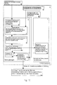
- Fig. 1 illustrates a first embodiment of an inventive Method and an apparatus according to the invention to provide traffic information for a particular Vehicle on a road traffic network
- the invention alternatively in the same way to different types of traffic networks is applicable as for the air, rail and Shipping traffic or combinations thereof.
- the basic idea is there each in vehicle-related, i.e. on respective initial conditions a vehicle in the form of a starting location and one Traffic information stored in a traffic control center at the start to be provided in such a way that on the one hand if possible good the current and forecast traffic situation on the central side at least in a relevant area of the environment Represent vehicle and on the other hand in their Data size is sufficiently small so that it is over conventional communication channels available for this purpose from the data processing center to the respective vehicle can be.
- the optimal one Route is done at the headquarters using a conventional one traffic-dependent route search method, also routing algorithm designated, determined from the point of view that a given, traffic-dependent cost function an optimal value assumes.
- the required travel time is selected as a cost function, i.e. as optimal route will be the one with the shortest travel time from Starting point calculated up to the respective route edge.
- Analog can however any other, conventionally for this purpose used cost function, e.g.
- the traffic data to be selected includes in particular the respective edge for the associated time of arrival predicted function value available in the control center for the route search used cost function. More in this Way according to the optimal route timely for each Track edge selected traffic data can be as needed are also taken into account.
- a vehicle-related part 2 as relevant components here and a vehicle-independent, on the entire traffic network related part 3 and a conventional, parent Travel time calculation part 4, in which continuously Travel time profiles for the different track edges the given traffic network for the current and for predefined forecast periods can be determined.
- Another Unit 19 provides other, current, as required and predicted traffic information is available that e.g. can be obtained from external information sources.
- Such a request contains in particular the information about the starting point, often the current one Vehicle location or information, of which in the headquarters the location is estimated and then a nearby edge in the Network can be assigned, and about the start time, often the current time, as a starting point for which the traffic information is desired.
- estimating the vehicle location if any, can provide information about the current location Direction of travel of the vehicle to be included the right choice between two parallel, opposing ones Hitting edges that e.g. the two directions of travel one Represent highway.
- the request is sent to headquarters 1 to a start condition setting unit 6, which is derived therefrom the mentioned starting conditions for the provision of the Traffic information extracted, i.e. especially the starting point and the start time.
- the routing module 7 receives the required traffic data from the higher-level travel time calculation unit 4.
- the calculation of the optimal route in this case the route with the shortest travel time, from the starting point to the respective road edge serves to determine the time of arrival at which the start time t 0 at the starting point S the vehicle driving off reaches the relevant edge of the road with an optimal route.
- the associated travel time value for the relevant road edge is selected from the travel time data available in the control center 1, in particular in the travel time calculation unit 4, for the different forecasting times, both for further route calculation and for further processing according to the invention as traffic information to be provided.
- the edge-specific travel time is usually subject to considerable fluctuations, on average depending on the time of day, day of the week, etc., and due to special traffic events, such as temporary traffic jams, construction sites, etc.
- each selected travel time value R i (t (j) ) of the route edges of the take-off surrounding area considered is explicitly taken into account as traffic information, ie as part of a traffic report to be transmitted.
- traffic information ie as part of a traffic report to be transmitted.
- variants with better adapted and / or less amount of data to be transmitted are possible.
- 5 and 6 illustrate a variant in which individualizable and thus identifiable traffic events are derived from the selected edge-specific travel times, which can then be tracked over time and reported as a whole in traffic information.
- individual traffic events can be derived directly from measured traffic data instead of travel times.
- the time axes are expediently discretized both for the current point in time and for the forecasting points in time, as is also common in conventional systems.
- a discretization interval of 10 minutes has been selected for the current time axis and a forecast interval of 5 minutes for the forecast time axis.
- the generated traffic events can on the one hand be distinguishable traffic objects, such as traffic jams, viscous traffic, free traffic, etc.
- FIG. 6 illustrates a possible procedure for archiving traffic events generated in this way with a identifiable event number.
- Each painted circle point in FIG. 6 symbolizes a point in time within a predefined forecast horizon h of, for example, 20 minutes, at which the generated event numbers for the traffic events are stored.
- the corresponding traffic events are calculated periodically at the current time t and remain valid for the selected forecast time increment t p of, for example, 5 minutes.
- the points lying on the diagonal D represent current traffic data.
- the discretization of the current time axis can be determined by a fixed interval of, for example, 10 minutes, additionally or alternatively also event-controlled.
- the current time 15:15 represents an additional determination time for which an additional process for determining traffic information to be provided is carried out due to the event.
- Deletion messages for previously forecast traffic information generated that are no longer traffic events at the current time include than they are in the same way in the current Traffic information occurs, whatever for any current time is repeated.
- the Deletion messages for each Traffic event whose traffic data is no longer in the current traffic data exist a corresponding one Deletion message generated. This is the case in the diagram of Fig. 7, the filled squares and the unfilled Circles above the diagonal on Fig. 7.
- the Deletion messages for the current time in the current Traffic information is included, a set of to be formed Deletion messages added, which again for each current time is repeated, i.e. the deletion messages are accepted from the current traffic data.
- deletion messages for a future Events associated with the forecast are then generated, if the events are generated in an earlier determination cycle were, but no longer in the current determination cycle available. Examples of this are shown in FIG. 7 with the filled in squares.
- Deletion message generator 10 is provided, in the example 1 in the vehicle-independent, network-related part 3 of Head office 1.
- This part 3 also contains a transformation unit 11, which data on current and forecasted by travel time data independent of the vehicle positions from the travel time calculation unit 4 receives and used in a vehicle side Converted data format.
- the transformed data will from the transformation unit 11 into an associated memory 12 registered, the current and forecast travel time data in the data format used by the vehicle for various Includes departure times and from the deletion message generator 10 can be read.
- the Deletion message generator 10 for the respective calculation time the disappearance of previously existing traffic conditions and to recognize the corresponding traffic information and generate the associated deletion messages.
- the list creation module generates from the information supplied 13 a total forecast list of all for the inquiring Vehicle, i.e. the specified starting location and the specified Relevant traffic data start time. These are then called Traffic report in the form of an overall forecast list to the requesting Vehicle transmitted where from a vehicle terminal there 14 on the basis of those included in the overall forecast list Traffic data and data stored in the vehicle individually an optimal route can be determined.
- the on-board system is capable of one for each Desired destination based on the timely transmitted edge-specific travel time information or equivalent information as well as any other traffic information an optimal route from the central unit 19 to find a desired destination, which of the central 1 for the provision of the relevant traffic information does not need to be known.
- This destination independence of the Provision of traffic information by the head office 1 according to the present process is essential since the transmission of a destination from the vehicle to a central office is often undesirable.
- the procedure according to the invention also has the advantage that the traffic information provided for the planned, at the specified starting time on The specified starting point of the start of the journey remains unchanged remain valid if a possibly envisaged Destination changes at short notice.
- the deletion message generator 10 is arranged in the vehicle-related part 2 of the control center 1 and Accordingly, the deletion messages are only vehicle-related, i.e. switched off to those applicable to the respective traffic data request Generated initial conditions, in which case he compared with the example of FIG. 1 additionally the traffic data information from the vehicle-related data transformation unit 9 receives and recycles.
- Fig. 9 shows an interpretation of the traffic center 1, which differs from differs from that according to FIG. 1 in that on the one hand vehicle-related system part 2, the data transformation unit 9 is eliminated and on the other hand that in the vehicle-independent system part 3 of the control center 1 provided memory 12 in addition to Storage of the delete messages generated by the delete message generator 10 is set up and also serves everyone other relevant for the creation of the overall forecast list Keep data from the list creation module 13 and supplied to the unit 19 and stored there independently of the vehicle can be.
- Fig. 10 corresponds to that of Fig. 8 with the exception that not only the Deletion report generation, but also the data transformation is purely vehicle-related, which is why the transformation unit 11 in the vehicle-independent system part 3 of the control center 1 is omitted and instead the memory 12 arranged in this system part 3 Traffic information to be stored in the vehicle-related System part 2 arranged data transformation unit 9 receives.
- Fig. 11 corresponds to that of Fig. 1 with the exceptions that here both the generation of deletion messages as well as all other data transformations is purely vehicle-related and secondly in the modified to form a customer database Memory 12 vehicle-specific saved messages sent be filed. Therefore all relevant units are in the Vehicle-dependent system part 2 of the control center arranged.
- the included for Transmission traffic information provided according to the invention in each case at least the information about the route-optimized specific time of arrival from the total forecast Travel time data belonging to travel times, or more generally Cost function values for the different sections of the route at least one containing the given starting location Part of the entire underlying traffic network or information derived from this selected travel time data.
- the amount of data to be transferred can be kept relatively low, and they are conventional on-board navigation systems can be used because they are with the forecasted, selected, edge-specific cost function value data (travel time data) through a conventional traffic-dependent route search method determining the optimal route to a variable Predeterminable, desired destination taking into account the current and expected future traffic conditions is possible.
- the selection can the current and forecast values of the cost function, e.g. Edge travel times, according to the invention by a
- the route is calculated when the route is calculated in the vehicle lead to the same optimal route that in the case of central-based Route guidance systems would be calculated.
- the inventive selection of the cost function values caused by the routing algorithm in the central office that the quality of route selection in autonomous route guidance systems achieved the quality of the central-based route guidance.
- the advantage of autonomous route guidance systems remains centralized systems that the destination of the vehicle at data processing in the head office is not necessary.
Abstract
Description
Die Erfindung bezieht sich auf ein Verfahren zur Bereitstellung
von Verkehrsinformationen für ein jeweiliges Fahrzeug auf einem
Verkehrswegenetz nach dem Oberbegriff des Anspruchs 1 sowie auf
eine zur Durchführung eines derartigen Verfahrens geeignete Vorrichtung
nach dem Oberbegriff des Anspruchs 5.The invention relates to a method for providing
of traffic information for a particular vehicle on a
Traffic network according to the preamble of
Verfahren und Vorrichtungen dieser Art werden beispielsweise dazu verwendet, für Straßenfahrzeuge, die ein gegebenes Straßenverkehrswegenetz befahren können, Verkehrsinformationen, d.h. den Verkehrszustand charakterisierende Informationen, bereitzustellen, um sie zur Zielführung, Routenwahl, Reisezeitschätzung etc. zu verwenden. Je nachdem, ob die Verarbeitung der Verkehrsinformationen primär fahrzeugseitig oder in einer Verkehrszentrale erfolgt, wird zwischen autonomen Systemen einerseits und zentralenbasierten Systemen andererseits unterschieden, wobei dynamische Zielführungssysteme einen wichtigen Anwendungsfall darstellen. Die dynamischen Zielführungssysteme unterscheiden sich von statischen dadurch, daß sie bei der Berechnung der optimalen Route Verkehrsdaten berücksichtigen, d.h. Daten über die Verkehrslage im Verkehrswegenetz.Methods and devices of this type are used, for example used for road vehicles that have a given road network can drive, traffic information, i.e. to provide information characterizing the traffic condition, around them for route guidance, route selection, travel time estimation etc. to use. Depending on whether the processing of traffic information primarily on the vehicle side or in a traffic control center takes place between autonomous systems on the one hand and central-based systems, on the other hand, where dynamic route guidance systems an important application represent. Distinguish the dynamic route guidance systems differ from static in that they calculate the optimal Take route data into account, i.e. Data about the Traffic situation in the traffic network.
In zentralenbasierten dynamischen Zielführungssystemen werden in einer Verkehrszentrale optimale Routen berechnet und diesbezügliche Daten zum Fahrzeug übertragen. Unter "optimal" wird dabei vorliegend eine Route verstanden, für die eine der Optimierungsprozedur zugrundegelegte Kostenfunktion einen Optimalwert, z.B. ein Minimum, annimmt, wobei als Kostenfunktion häufig die Reisezeit benutzt wird. Ein spezieller Algorithmus zur Berechnung schnellster Routen in einem Verkehrswegenetz ist in dem Zeitschriftenaufsatz E.W. Dijkstra, A note on two problems in connection with graphs, Numer. Math. 1, Seite 269 beschrieben. Alternativ ist jedoch auch eine andere Kostenfunktion verwendbar, z.B. der Energieverbrauch, der zum Befahren eines jeweiligen Streckenabschnittes, nachfolgend auch Streckenkante oder kurz Kante bezeichnet, benötigt wird. In autonomen dynamischen Zielführungssystemen wird die optimale Route fahrzeugseitig auf der Basis von aktuellen Verkehrsinformationen berechnet, die von einer Verkehrszentrale zum Fahrzeug übertragen werden, z.B. in Form herkömmlicher TMC-Verkehrsmeldungen.In central-based dynamic route guidance systems, in a traffic center calculates optimal routes and related routes Transfer data to the vehicle. Under "optimal" is thereby In the present case understood a route for which one of the optimization procedures an optimal value, e.g. a minimum, assuming the travel time as a cost function is used. A special algorithm for calculation fastest routes in a traffic network is in the journal article E.W. Dijkstra, A note on two problems in connection with graphs, number. Math. 1, page 269. Alternatively however, another cost function can also be used, e.g. the energy consumption required to drive each one Section of the route, hereinafter also the edge of the route or short Edge is required. In autonomous dynamic route guidance systems the optimal route is on the vehicle side on the Based on current traffic information calculated by a Traffic control center to the vehicle, e.g. in Form of conventional TMC traffic reports.
Die meisten bekannten dynamischen Zielführungssysteme beschränken sich auf die Bereitstellung und Berücksichtigung aktueller Verkehrsinformationen, d.h. von Informationen über die aktuelle Verkehrslage im Verkehrswegenetz, wie sie vor allem durch über das Verkehrswegenetz verteilt angeordnete Verkehrslagedetektoren gewonnen werden. Nun kann sich jedoch die Verkehrslage, insbesondere verkehrsflußrelevante Zustände wie Verkehrsstaus und dergleichen, und damit die jeweils optimale Route zwischen zwei Punkten des Wegenetzes im Lauf der Zeit sehr schnell gravierend ändern. Dadurch kann es zu drastischen Abweichungen des sich für eine tatsächliche Fahrt ergebenden Wertes der Kostenfunktion, wie der Reisezeit oder des Fahrzeugenergieverbrauchs, von dem zur berechneten optimalen Route gehörigen, geschätzten Kostenfunktionswert kommen.Limit most known dynamic route guidance systems focus on the provision and consideration of current Traffic information, i.e. of information about the current Traffic situation in the traffic network, especially as a result of the traffic route network distributes traffic situation detectors be won. Now, however, the traffic situation, in particular Conditions relevant to traffic flow such as traffic jams and the like, and thus the optimal route between two Points in the route network quickly became serious over time to change. This can lead to drastic deviations for an actual trip of the value of the cost function, such as travel time or vehicle energy consumption, from which Estimated cost function value associated with the calculated optimal route come.
Um hier eine Verbesserung zu erreichen, wurde bereits verschiedentlich die Durchführung von Verkehrslageprognosen und die Berücksichtigung daraus gewonnener, prognostizierter Verkehrsdaten zusätzlich zu aktuellen Verkehrsdaten bei der Fahrzeugzielführung, Routenfindung und/oder Reisezeitschätzung vorgeschlagen, siehe die Patentschrift DE 195 26 148 C2, die Offenlegungsschriften DE 196 47 127 A1 und DE 198 06 197 A1 sowie die nicht vorveröffentlichte, ältere deutsche Patentanmeldung 198 35 979.9. In order to achieve an improvement here, has been various the implementation of traffic situation forecasts and the consideration predicted traffic data obtained therefrom in addition to current traffic data for vehicle route guidance, Suggested route determination and / or travel time estimation, see patent specification DE 195 26 148 C2, the published documents DE 196 47 127 A1 and DE 198 06 197 A1 and the not Pre-published, older German patent application 198 35 979.9.
Derartige Verkehrsprognoseverfahren werden wegen des damit verbundenen Rechenaufwandes in einer jeweiligen Verkehrszentrale durchgeführt, die dann den beteiligten Fahrzeugen die prognostizierten zusätzlich zu aktuellen Verkehrsdaten zur Verfügung stellen kann. Eine Schwierigkeit stellt hierbei die Datenmenge dar, denn einerseits können Verkehrsinformationen aufgrund der beschränkten Kapazität der zur Verfügung stehenden Kommunikationskanäle nur in sehr begrenzter Menge von der Zentrale zum jeweiligen Fahrzeug übertragen werden, und andererseits ist in der Zentrale oft nicht genau bekannt, welche Verkehrsinformationen ein fahrzeugseitiges Zielführungssystem zur Berechnung verkehrsabhängig optimaler Routen mit einem fahrzeugseitig vorhandenen Routensuchalgorithmus benötigt. Es besteht daher Bedarf nach Verfahren und Vorrichtungen, mit denen in einer möglichst geringen, zu übertragenden Datenmenge zuverlässige und fahrzeugseitig gut auswertbare Verkehrsinformationen bereitgestellt werden können, die sowohl aktuelle als auch für die relevanten Streckenabschnitte zeitrichtig prognostizierte Daten über die zu erwartende Verkehrslage berücksichtigen.Such traffic forecasting methods are used because of the associated Computing effort in a respective traffic center carried out, which then predicted the vehicles involved in addition to current traffic data can put. One problem here is the amount of data because on the one hand traffic information can be limited capacity of the available communication channels only in very limited quantities from the head office to the respective one Vehicle are transmitted, and on the other hand is in the Head office often does not know exactly what traffic information a vehicle-based route guidance system for calculation depending on traffic optimal routes with an existing vehicle Route search algorithm needed. There is therefore a need for Methods and devices with which the lowest possible amount of data to be transferred reliably and on the vehicle side traffic information that can be easily evaluated can be provided, the current as well as for the relevant route sections timely predicted data about the expected Take traffic conditions into account.
In der Offenlegungsschrift DE 198 06 197 A1 sind Verfahren und Vorrichtungen der eingangs genannten Art beschrieben, bei denen von einer Verkehrszentrale aktuelle und prognostizierte Verkehrsdaten geordnet nach sogenannten Bezugsgebieten bereitgestellt und über einen zugehörigen Kommunikationskanal an das Fahrzeug übertragen werden. Zur Konstruktion der Bezugsgebiete werden ausgehend von einem Startzeitpunkt aufeinanderfolgende Prognosezeitpunkte festgelegt und diesen jeweils als Bezugsgebiet ein Wegenetz-Teilbereich zugeordnet, der ein Gebiet beschreibt, in welchem sich das Fahrzeug im Zeitraum zwischen dem betrachteten und dem nächsten Prognosezeitpunkt voraussichtlich befindet. Zur Bestimmung der Bezugsgebiete wird vorgeschlagen, die voraussichtliche Fahrzeugentfernung vom Startort heranzuziehen, wie sie sich zum betreffenden Zeitpunkt aus abgelegten Geschwindigkeitsdaten über die mittlere angenommene Fahrzeuggeschwindigkeit im betrachteten Wegenetzbereich ergibt, die fest oder straßentypabhängig unterschiedlich vorgegeben werden können.The published patent application DE 198 06 197 A1 describes methods and Devices of the type mentioned in which from a traffic center current and forecast traffic data arranged according to so-called reference areas and via an associated communication channel to the Vehicle can be transferred. For the construction of the reference areas are consecutive from a start time Predicted times and each as a reference area assigned a route network section that describes an area, in which the vehicle is in the period between considered and probably the next forecast time located. To determine the reference areas, it is proposed that to take the expected vehicle distance from the starting point, how they are derived from stored speed data at the relevant time about the average assumed vehicle speed in the considered route network area results in the fixed or can be specified differently depending on the road type.
Der Erfindung liegt als technisches Problem die Bereitstellung eines Verfahrens und einer Vorrichtung der eingangs genannten Art zugrunde, mit denen mit relativ geringem Aufwand vergleichsweise zuverlässige und genaue Verkehrsinformationen zur weiteren Nutzung für ein jeweiliges Fahrzeug auf einem Verkehrswegenetz bereitgestellt werden können, insbesondere für ein fahrzeugseitig vorhandenes, autonomes dynamisches Zielführungssystem zur Zielführung, Routenplanung etc.The invention is a technical problem of providing a method and a device of the aforementioned Kind of basis, comparatively with those with relatively little effort reliable and accurate traffic information for further Use for a particular vehicle on a traffic network can be provided, in particular for a vehicle side existing, autonomous dynamic route guidance system for Route guidance, route planning etc.
Die Erfindung löst dieses Problem durch die Bereitstellung eines
Verfahrens mit den Merkmalen des Anspruchs 1 sowie einer zu dessen
Durchführung geeigneten Vorrichtung mit den Merkmalen des
Anspruchs 5. Charakteristischerweise enthält die Bereitstellung
von Verkehrsinformationen bei diesem Verfahren und dieser Vorrichtung
zunächst eine zentralenseitig durchgeführte, vom jeweiligen
Startort und Startzeitpunkt ausgehende Ermittlung von bezüglich
einer vorgegebenen, verkehrsabhängigen Kostenfunktion,
wie der Reisezeit, optimalen Routen zu den Streckenkanten wenigstens
eines den Startort enthaltenden Wegenetz-Teilbereiches.
Das verwendete Routensuchverfahren arbeitet verkehrsdatenabhängig
unter Berücksichtigung von in der Verkehrszentrale vorhandenen,
aktuellen und prognostizierten Verkehrsdaten, welche die
aktuellen und prognostizierten Funktionswerte der Kostenfunktion
für die einzelnen Streckenkanten des Wegenetzes sowie je nach
Anwendungsfall weitere Daten über den aktuellen und den zukünftigen
Verkehrszustand umfassen. Die Verkehrsdaten über den Zustand
zum aktuellen Zeitpunkt ebenso wie zu den verschiedenen
vorgegebenen Prognosezeitpunkten für die betrachteten Streckenkanten
liegen in der Verkehrs zentrale schon abrufbar vor oder
können von ihr jedenfalls durch ein herkömmliches Verkehrsprognoseverfahren
bereitgestellt werden. Aus der für die jeweilige
Streckenkante berechneten optimalen Route folgt unmittelbar die
zugehörige vorausgeschätzte Ankunftszeit, zu der ein am Startort
zum Startzeitpunkt startendes und die optimale Route befahrendes
Fahrzeug voraussichtlich die betreffende Streckenkante erreicht.The invention solves this problem by providing a
Method with the features of
Wesentlich ist nun, daß aus den in der Verkehrszentrale zur jeweiligen Streckenkante vorhandenen aktuellen und prognostizierten, d.h. zu den vorgegebenen Prognosezeiten zu erwartenden Werten der Kostenfunktion derjenige Kostenfunktionswert ausgewählt wird, der zum Ankunftszeitpunkt gemäß der optimalen Route gehört. Neben dem ausgewählten Kostenfunktionswert können je nach Bedarf weitere, in der Verkehrszentrale für die gegebene Strekkenkante und den gegebenen Ankunftszeitpunkt vorliegende Verkehrsdaten ausgewählt werden. Erfindungsgemäß ist charakteristisch, daß es gerade die auf diese Weise kantenspezifisch und entsprechend den berechneten optimalen Routen zeitrichtig ausgewählten Kostenfunktionswerte für die einzelnen Streckenkanten des betrachteten Wegenetz-Teilbereiches sind, die als übertragbare Verkehrsdaten in der Zentrale aufbereitet und bereitgestellt werden oder jedenfalls einen Teil dieser zur Übertragung aufbereiteten Verkehrsdaten bilden.It is now essential that from the in the traffic center to the respective Route edge existing current and predicted, i.e. values to be expected at the specified forecast times that cost function value is selected for the cost function that belongs to the optimal route at the time of arrival. In addition to the selected cost function value, depending on Need more in the traffic control center for the given route edge and traffic data available at the given time of arrival to be selected. According to the invention, it is characteristic that it is precisely the edge-specific and selected according to the calculated optimal routes Cost function values for the individual track edges of the considered route network sub-area are those that are transferable Traffic data processed and provided at the headquarters become or at least part of it for transmission form processed traffic data.
Mit dieser Vorgehensweise lassen sich relativ zuverlässige aktuelle und prognostizierte Verkehrslagedaten als aus Gründen der Übertragungskapazität möglichst kompakte Datenmenge bereitstellen. Insbesondere ist schon ein fahrzeugseitiges Zielführungssystem herkömmlicher Bauart ohne bauliche Veränderungen in der Lage, mit derartigen übertragenen Verkehrsinformationen eine optimale Zielführung oder Routenplanung vorzunehmen, bei der nicht nur von der aktuellen Verkehrslage Gebrauch gemacht wird, sondern die darüber hinaus die voraussichtliche zukünftige Verkehrslage berücksichtigt, da diese dem System über die übermittelten Kostenfunktionswerte für die relevanten Steckenkanten vermittelt wird. Außerdem wird eine deutlich höhere Genauigkeit für solche autonomen Zielführungsprozesse unter Verwendung der erfindungsgemäß bereitgestellten Verkehrsinformationen im Vergleich zu herkömmlichen Systemen erreicht, bei denen die übertragenen Verkehrsinformationen allenfalls grobe Informationen über eventuell in einem recht großräumigen Gebiet zu einem späteren Prognosezeitpunkt zu erwartende Verkehrszustandsobjekte, wie Staus, zähfließender Verkehr etc., enthalten, ohne daß erfindungsgemäß signifikant höhere Datenmengen übertragen werden müssen. Zudem wird die Genauigkeit der Auswahl der Kostenfunktionswerte gegenüber der Genauigkeit bei der in herkömmlichen Systemen gebräuchlichen Bestimmung von wie auch immer gearteten Bezugsgebieten, d.h. Entfernungszonen um den jeweiligen Startort, erhöht und es entfällt die Unterscheidung der Verkehrsinformationen nach solchen Bezugsgebieten bzw. Entfernungszonen.With this procedure you can get relatively reliable current ones and forecast traffic situation data as for the sake of Make the transmission capacity as compact as possible. In particular, there is already a route guidance system on the vehicle conventional design without structural changes in the position optimal with such transmitted traffic information To carry out route guidance or route planning in the case of not only the current traffic situation is used, but which furthermore the expected future traffic situation taken into account, since these are transmitted to the system via the Cost function values for the relevant plug edges is conveyed. It also has a significantly higher accuracy for such autonomous route guidance processes using the Comparison of traffic information provided according to the invention to conventional systems where the transmitted Traffic information at most rough information over possibly in a fairly large area to a later one Traffic condition objects to be expected, such as traffic jams, slow-moving traffic, etc., without, according to the invention significantly higher amounts of data are transmitted have to. In addition, the accuracy of the selection of the cost function values versus the accuracy of that in conventional Systems common determination of whatever kind Reference areas, i.e. Distance zones around the respective starting point, increased and the distinction between traffic information is no longer available according to such reference areas or distance zones.
Bei einem nach Anspruch 2 weitergebildeten Verfahren und einer
zu dessen Durchführung geeignet weitergebildeten Vorrichtung
nach Anspruch 6 beinhaltet die Aufbereitung der bereitzustellenden
Verkehrsinformationen, daß die übertragungsrelevanten Verkehrsdaten
in ein fahrzeugseitig verwendetes Datenformat gebracht
werden, d.h. in ein Datenformat, das in dem fahrzeugseitigen
Endgerät verwendet wird, welches die Verkehrsinformationen
nach Übertragung empfängt und weiterverarbeitet. Dadurch können
bestehende Fahrzeug-Endgeräte praktisch unverändert für das vorliegende,
erfindungsgemäße System eingesetzt werden. Wenn z.B.
das Fahrzeug-Endgerät als Verkehrsinformationen lediglich Staumeldungen
verarbeiten kann, können daran angepaßt zentralenseitig
die für die relevanten Streckenkanten ausgewählten Kostenfunktionswerte,
soweit sie einem stauartigen Verkehrszustand
entsprechen, zu fiktiven Staumeldungen aufbereitet und in dieser
Weise übertragen werden.In a further developed method according to
Bei einem nach Anspruch 3 weitergebildeten Verfahren beinhaltet die Verkehrsdatenaufbereitung eine Erzeugung von Verkehrsereignissen als individuelle verkehrliche Objekte, die entsprechend identifizierbar sind. Solche Ereignisse können beispielsweise erkannten, besonderen Verkehrsflußzuständen, wie Stau, zähflüssiger Verkehr etc., oder einer detektierten übermäßigen Abweichung des ausgewählten Kostenfunktionswertes von einem normalerweise zu erwartenden Referenz-Kostenfunktionswert zugeordnet werden, wobei der Referenz-Kostenfunktionswert z.B. den für ungestörten, freien Verkehr geltenden Kostenfunktionswert repräsentieren kann.In a method further developed according to claim 3 the traffic data preparation a generation of traffic events as individual traffic objects, accordingly are identifiable. Such events can, for example recognized, special traffic flow conditions, such as traffic jams, more viscous Traffic, etc., or an excessive deviation detected of the selected cost function value of one normally assigned to the expected reference cost function value with the reference cost function value e.g. the one for undisturbed, represent free movement functional cost value can.
Bei einem nach Anspruch 4 weitergebildeten Verfahren und einer
zu dessen Durchführung geeignet weitergebildeten Vorrichtung
nach Anspruch 7 beinhaltet die Verkehrsdatenaufbereitung eine
Erzeugung von Löschmeldungen, mit denen spezifisch solche Verkehrsinformationen,
die zu einem früheren Zeitpunkt bereitgestellt
wurden, als aktuell nicht mehr gültig indiziert werden
und gelöscht werden können. Dies verhindert, daß eine aufgrund
zwischenzeitlich veränderter Verkehrslage nicht mehr gültige,
frühere Verkehrsinformation zu lang im Fahrzeug-Endgerät gespeichert
bleibt und eventuell andere, davon abhängige Verkehrsinformationen
verfälscht, wodurch es im Fahrzeug aufgrund daraus
resultierender falscher Kostenfunktionswerte zur Berechnung einer
nicht optimalen Route kommen kann.In a further developed according to
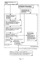
Vorteilhafte Ausführungsbeispiele der Erfindung sind in den Zeichnungen dargestellt und werden nachfolgend beschrieben. Hierbei zeigen:
- Fig. 1
- ein schematisches Funktionsblockdiagramm eines Verfahrens und einer Vorrichtung zur Bereitstellung von Verkehrsinformationen für ein jeweiliges Fahrzeug auf einem Verkehrswegenetz,
- Fig. 2
- einen Ausschnitt des im System von Fig. 1 betrachteten Verkehrswegenetzes zur Veranschaulichung eines verwendeten Routensuchverfahrens,
- Fig. 3
- ein Diagramm eines beispielhaften Reisezeitverlaufs für eine Streckenkante von Fig. 2,
- Fig. 4
- ein Diagramm entsprechend Fig. 3, jedoch für eine andere Streckenkante,
- Fig. 5
- ein Diagramm entsprechend Fig. 3 zur Veranschaulichung einer Ereignisgenerierung,
- Fig. 6
- ein Diagramm zur Veranschaulichung der zeitdiskreten Bereitstellung von Verkehrsdaten,
- Fig. 7
- ein Diagramm entsprechend Fig. 6 zur Veranschaulichung der Erzeugung von Löschmeldungen,
- Fig. 8
- ein Funktionsblockdiagramm entsprechend Fig. 1, jedoch mit fahrzeugbezogener statt fahrzeugunabhängiger Löschmeldungserzeugung,
- Fig. 9
- ein Funktionsblockdiagramm entsprechend Fig. 1, jedoch mit fahrzeugunabhängiger Datentransformation,
- Fig. 10
- ein Funktionsblockdiagramm entsprechend Fig. 8, jedoch mit fahrzeugbezogener Datentransformation, und
- Fig. 11
- ein Funktionsblockdiagramm entsprechend Fig. 8, jedoch nur mit fahrzeugbezogener Datentransformation und fahrzeugbezogener Datenhaltung versandter Meldungen.
- Fig. 1
- 1 shows a schematic functional block diagram of a method and a device for providing traffic information for a respective vehicle on a traffic route network,
- Fig. 2
- 1 shows a section of the traffic route network considered in the system of FIG. 1 to illustrate a route search method used,
- Fig. 3
- 2 shows a diagram of an exemplary travel time profile for a route edge from FIG. 2,
- Fig. 4
- 3, but for a different line edge,
- Fig. 5
- 3 shows a diagram corresponding to FIG. 3 to illustrate an event generation,
- Fig. 6
- 1 shows a diagram to illustrate the time-discrete provision of traffic data,
- Fig. 7
- 6 shows a diagram corresponding to FIG. 6 to illustrate the generation of deletion messages,
- Fig. 8
- 1, but with vehicle-related instead of vehicle-independent deletion message generation,
- Fig. 9
- 2 shows a functional block diagram corresponding to FIG. 1, but with vehicle-independent data transformation,
- Fig. 10
- 8, but with vehicle-related data transformation, and
- Fig. 11
- 8, but only with vehicle-related data transformation and vehicle-related data storage of messages sent.
Fig. 1 veranschaulicht ein erstes Ausführungsbeispiel eines erfindungsgemäßen Verfahrens und einer erfindungsgemäßen Vorrichtung zur Bereitstellung von Verkehrsinformationen für ein jeweiliges Fahrzeug auf einem Straßenverkehrswegenetz, wobei die Erfindung alternativ in gleicher Weise auf andersartige Verkehrswegenetze anwendbar ist, wie für den Luft-, Schienen- und Schiffsverkehr oder Kombinationen hiervon. Die Grundidee besteht jeweils darin, fahrzeugbezogene, d.h. auf jeweilige Anfangsbedingungen eines Fahrzeugs in Form eines Startorts und eines Startzeitpunkts abgestellte Verkehrsinformationen in einer Verkehrszentrale derart bereitzustellen, daß sie einerseits möglichst gut die aktuelle und zentralenseitig prognostizierte Verkehrslage wenigstens in einem relevanten Umfeldbereich des betreffenden Fahrzeugs repräsentieren und andererseits in ihrem Datenumfang ausreichend gering sind, so daß sie über herkömmlich für diesen Zweck zur Verfügung stehende Kommunikationskanäle von der datenaufbereitenden Zentrale zum jeweiligen Fahrzeug übertragen werden können.Fig. 1 illustrates a first embodiment of an inventive Method and an apparatus according to the invention to provide traffic information for a particular Vehicle on a road traffic network, the invention alternatively in the same way to different types of traffic networks is applicable as for the air, rail and Shipping traffic or combinations thereof. The basic idea is there each in vehicle-related, i.e. on respective initial conditions a vehicle in the form of a starting location and one Traffic information stored in a traffic control center at the start to be provided in such a way that on the one hand if possible good the current and forecast traffic situation on the central side at least in a relevant area of the environment Represent vehicle and on the other hand in their Data size is sufficiently small so that it is over conventional communication channels available for this purpose from the data processing center to the respective vehicle can be.
Dies wird vorliegend dadurch erreicht, daß aus zentralenseitig vorhandenen, aktuellen und prognostizierten Verkehrsdaten für die verschiedenen Streckenkanten des Verkehrswegenetzes jeweils speziell diejenigen ausgewählt werden, die für denjenigen Ankunftszeitpunkt gelten, zu dem das jeweilige Fahrzeug bei einer prognostizierten, am gegebenen Startort zum gegebenen Startzeitpunkt beginnenden Fahrt entlang einer berechneten optimalen Route die jeweilige Streckenkante erreicht bzw. befährt. Die optimale Route wird dabei in der Zentrale mittels eines herkömmlichen verkehrsabhängigen Routensuchverfahrens, auch Routing-Algorithmus bezeichnet, nach dem Gesichtspunkt ermittelt, daß eine vorgegebene, verkehrsabhängige Kostenfunktion einen Optimalwert annimmt. In den betrachteten Ausführungsbeispielen ist als Kostenfunktion die benötigte Reisezeit gewählt, d.h. als optimale Route wird diejenige mit der kürzesten Reisezeit vom Startort bis zur jeweiligen Streckenkante berechnet. Analog kann jedoch eine beliebige andere, für diesen Zweck herkömmlicherweise verwendete Kostenfunktion benutzt werden, z.B. der für das Befahren vom Fahrzeug benötigte Energie- bzw. Kraftstoffverbrauch. Zu den auszuwählenden Verkehrsdaten gehört insbesondere der zur jeweiligen Kante für den zugehörigen Ankunftszeitpunkt in der Zentrale vorhandene prognostizierte Funktionswert der für die Routensuche verwendeten Kostenfunktion. Weitere in dieser Weise gemäß der optimalen Route zeitrichtig für die jeweilige Streckenkante ausgewählte Verkehrsdaten können je nach Bedarf zusätzlich berücksichtigt werden.This is achieved in the present case in that from the central side existing, current and forecast traffic data for the different route edges of the traffic network specifically those are selected for those arrival times apply to which the respective vehicle at a predicted at the given starting location at the given starting time beginning journey along a calculated optimal route the respective track edge reaches or travels. The optimal one Route is done at the headquarters using a conventional one traffic-dependent route search method, also routing algorithm designated, determined from the point of view that a given, traffic-dependent cost function an optimal value assumes. In the considered embodiments the required travel time is selected as a cost function, i.e. as optimal route will be the one with the shortest travel time from Starting point calculated up to the respective route edge. Analog can however any other, conventionally for this purpose used cost function, e.g. the one for that Driving energy or fuel consumption required by the vehicle. The traffic data to be selected includes in particular the respective edge for the associated time of arrival predicted function value available in the control center for the route search used cost function. More in this Way according to the optimal route timely for each Track edge selected traffic data can be as needed are also taken into account.
Bei der in Fig. 1 schematisch gezeigten Systemauslegung ist eine
punktiert umrahmt gezeichnete Verkehrszentrale 1 vorgesehen, die
als hier relevante Bestandteile einen fahrzeugbezogenen Teil 2
und einen fahrzeugunabhängigen, sich auf das gesamte Verkehrswegenetz
beziehenden Teil 3 sowie einen herkömmlichen, übergeordneten
Reisezeitberechnungsteil 4 aufweist, in welchem fortlaufend
Reisezeitverläufe für die verschiedenen Streckenkanten
des vorgegebenen Verkehrswegenetzes für den aktuellen und für
vorgegebene Prognosezeiträume ermittelt werden. Eine weitere
Einheit 19 stellt je nach Bedarf vorgesehene sonstige, aktuelle
und prognostizierte Verkehrsinformationen zur Verfügung, die
z.B. von externen Informationsquellen erhalten werden.In the system design shown schematically in FIG
dotted framed
Von den systembeteiligten Fahrzeugen können über dortige Sendegeräte
5 Anfragen nach Verkehrsdaten bzw. Verkehrsinformationen
zur Zentrale 1 gesendet werden. Eine solche Anfrage enthält insbesondere
die Informationen über den Startort, häufig der momentane
Fahrzeugort bzw. Informationen, von denen in der Zentrale
der Standort abgeschätzt und danach einer naheliegenden Kante im
Netz zugeordnet werden kann, und über den Startzeitpunkt, häufig
der gegenwärtige Zeitpunkt, als Ausgangsbedingungen, für welche
die Verkehrsinformationen gewünscht werden. Bei der Abschätzung
des Fahrzeugorts kann, falls vorhanden, Information über die gegenwärtige
Fahrtrichtung des Fahrzeugs mit einbezogen werden, um
die richtige Wahl zwischen zwei parallel verlaufenden, gegenläufigen
Kanten zu treffen, die z.B. die beiden Fahrtrichtungen einer
Autobahn repräsentieren. Die Anfrage wird in der Zentrale 1
einer Startbedingungs-Festlegungseinheit 6 zugeleitet, die daraus
die erwähnten Ausgangsbedingungen für die Bereitstellung der
Verkehrsinformationen extrahiert, d.h. insbesondere den Startort
und den Startzeitpunkt.Of the vehicles involved in the system can transmit devices there
5 requests for traffic data or traffic information
be sent to
Diese Anfangsdaten übergibt die Startbedingungs-Festlegungseinheit
6 einem wie diese zum fahrzeugbezogenen Zentralenteil 2
gehörigen, nachgeschalteten Routing-Modul 7. Dieses berechnet
dann, wie für einen den Startort S enthaltenden Wegenetz-Teilbereich
in Fig. 2 schematisch veranschaulicht, die hinsichtlich
der Kostenfunktion "Reisezeit" optimale Route für eine zum Anfangszeitpunkt
t0 beginnende Fahrt vom Startpunkt S zu jeder
Straßenkante p=1,2,... in der Umgebung des Startpunktes S auf
der Basis eines verkehrsabhängigen, d.h. Daten über die aktuelle
und prognostizierte Verkehrslage berücksichtigenden Routensuchverfahrens,
auch Routing-Algorithmus bezeichnet. Derartige Routing-Algorithmen
sind an sich bekannt und bedürfen daher hier
keiner weiteren Erläuterung. Die benötigten Verkehrsdaten erhält
das Routing-Modul 7 von der übergeordneten Reisezeitberechnungseinheit
4. Die Berechnung der optimalen Route, d.h. in diesem
Fall der Route mit der kürzesten Reisezeit, vom Startpunkt zur
jeweiligen Straßenkante dient dazu, den Ankunftszeitpunkt zu bestimmen,
zu dem ein zum Anfangszeitpunkt t0 am Startort S losfahrendes
Fahrzeug bei optimaler Fahrtroute die betreffende Straßenkante
erreicht. Für diesen Ankunftszeitpunkt wird dann aus
den in der Zentrale 1, insbesondere in der Reisezeitberechnungseinheit
4, für die verschiedenen Prognosezeitpunkte vorhandenen
Reisezeitdaten der zugehörige Reisezeitwert für die betreffende
Straßenkante sowohl zur weiteren Routen-Berechnung als auch zur
erfindungsgemäßen weiteren Aufbereitung als bereitzustellende
Verkehrsinformation ausgewählt.The starting
Diese Auswahl ist in den Fig. 3 und 4 anhand zweier konkreter
Beispiele näher veranschaulicht. Fig. 3 zeigt für eine herausgegriffene
Straßenkante p=5 beispielhaft den durch die Reisezeitberechnungseinheit
4 prognostisch ermittelten und in ihr gehaltenen
Reisezeitverlauf R5(t) in Abhängigkeit von der Zeit t. Wie
mit der variierenden Kennlinie veranschaulicht, ist die kantenspezifische
Reisezeit üblicherweise beträchtlichen Schwankungen
unterworfen, und zwar schon im Mittel je nach Tageszeit, Wochentag
etc. sowie durch besondere Verkehrsereignisse, wie temporäre
Staus, Baustellen etc. Aus dem in der Zentrale 1 vorliegenden
Reisezeitverlauf R5 wird nun die zu demjenigen Ankunftszeitpunkt
t(1) gehörige prognostizierte Reisezeit R5(t(1)) ausgewählt, zu dem
die Streckenkante p=5 vom Startort S aus über die optimale,
schnellste Route erreicht werden kann. Für dieses Beispiel führt
diese optimale Route, wie in Fig. 2 zu erkennen, über die Strekkenkante
p=3 vom Startort S bis zum Beginn der Streckenkante p=5
mit einer aktuell geschätzten Reisezeit R3(t0). This selection is illustrated in more detail in FIGS. 3 and 4 using two concrete examples. FIG. 3 shows, for a selected road edge p = 5, the travel time curve R 5 (t) determined prognostically by the travel
Fig. 4 zeigt ein analoges Beispiel für die herausgegriffene
Straßenkante p=6. Die optimale Route für diese Streckenkante
führt über die Streckenkante p=2 mit einer für den aktuellen Anfangszeitpunkt
t0 prognostizierten Reisezeit R2(t0), die somit
den Ankunftszeitpunkt t(2) für die Kante p=6 darstellt. Dementsprechend
wird aus den für diese Kante p=6 in der Zentrale 1
vorliegenden, prognostizierten Reisezeitverlaufsdaten R6(t) der
zugehörige Reisezeitwert R6(t(2)) als bereitzustellende Verkehrsinformation
für diesen Streckenabschnitt ausgewählt.4 shows an analogous example for the picked-out road edge p = 6. The optimum route for this route edge via the roadway section p = 2 with a for the current start time t 0 predicted travel time R 2 (t 0), which thus the arrival time t (2) p of the edge = 6 illustrates. Accordingly, from the forecast travel time history data R 6 (t) available for this edge p = 6 in the
Die solchermaßen ausgewählten Reisezeiten Ri(t(j)) für jede Kante
p=i zum Ankunftszeitpunkt t(j) gemäß der zugehörigen optimalen
Route j werden dann nebst eventuell weiteren zeitentsprechenden
Verkehrsdaten über diese Kante, wie z.B. die zugehörige Ankunftszeit
t(j) selbst, vom Routing-Modul 7 vor Einspeicherung in
einen nachgeschalteten Reisezeitauswahlspeicher 8 geeignet aufbereitet.
Aus diesem werden sie von einer anschließenden fahrzeugbezogenen
Datentransformationseinheit (9) ausgelesen und
weiterverarbeitet, was insbesondere eine Übersetzung der Daten
in ein Datenformat beinhaltet, das in den fahrzeugseitigen Systemen
verwendet und daher von diesen verstanden wird. Im übrigen
gibt es für die Datenaufbereitung verschiedene Möglichkeiten.The travel times R i (t (j) ) selected in this way for each edge p = i at the time of arrival t (j) in accordance with the associated optimal route j are then, along with any other time-related traffic data about this edge, such as the associated arrival time t (j). itself, appropriately prepared by the
In einer ersten Variante kann vorgesehen sein, jedem ausgewählten Reisezeitwert Ri(t(j)) der Streckenkanten des berücksichtigten Startort-Umgebungsbereichs explizit als Verkehrsinformation, d.h. als Bestandteil einer zu übertragenden Verkehrsmeldung, zu berücksichtigen. Je nach fahrzeugseitig vorhandener Systemintelligenz sind Varianten mit besser angepaßter und/oder geringerer zu übertragender Datenmenge möglich. So veranschaulichen die Fig. 5 und 6 eine Variante, bei der aus den ausgewählten kantenspezifischen Reisezeiten individualisierbare und damit identifizierbare Verkehrsereignisse abgeleitet werden, die dann in ihrer zeitlichen Entwicklung verfolgt und in Verkehrsinformationen als Ganzes gemeldet werden können. Alternativ dazu können individuelle Verkehrsereignisse direkt aus gemessenen Verkehrsdaten statt aus Reisezeiten abgeleitet werden. Dazu werden zweckmäßigerweise die Zeitachsen sowohl für den aktuellen Zeitpunkt als auch für die Prognosezeitpunkte diskretisiert, wie dies auch bei herkömmlichen Systemen üblich ist. So ist im Beispiel von Fig. 6 für die aktuelle Zeitachse ein Diskretisierungsintervall von 10min und für die Prognosezeitachse ein Prognoseintervall von 5min gewählt. Die generierten Verkehrsereignisse können zum einen unterscheidbare verkehrliche Objekte, wie Staus, zähflüssiger Verkehr, freier Verkehr etc., sein. Zum anderen besteht die Möglichkeit, die jeweils ausgewählte kantenspezifische Reisezeit mit einem Referenzwert zu vergleichen, und für den Fall, daß sich eine Abweichung um mehr als ein vorgebbarer Schwellwert ergibt, diese Abweichung als ein Verkehrsereignis zu identifizieren. Dies ist in Fig. 5 beispielhaft anhand des Reisezeitverlaufs für die Kante p=5 gemäß Fig. 3 veranschaulicht. Als Referenzwert wird hier, wie punktiert gezeichnet, eine zeitlich konstante, mittlere Reisezeit R5R angenommen, wie sie für den Fall des freien, ungestörten Verkehrs prognostiziert wird. Überschreitet die ausgewählte Reisezeit R5(t(1)), wie gezeigt, den Referenzwert R5R um mehr als einen Schwellwert RS, wird für die betreffende Streckenkante p=5 das Auftreten eines entsprechenden Verkehrsereignisses angenommen.In a first variant, it can be provided that each selected travel time value R i (t (j) ) of the route edges of the take-off surrounding area considered is explicitly taken into account as traffic information, ie as part of a traffic report to be transmitted. Depending on the system intelligence available on the vehicle, variants with better adapted and / or less amount of data to be transmitted are possible. 5 and 6 illustrate a variant in which individualizable and thus identifiable traffic events are derived from the selected edge-specific travel times, which can then be tracked over time and reported as a whole in traffic information. Alternatively, individual traffic events can be derived directly from measured traffic data instead of travel times. For this purpose, the time axes are expediently discretized both for the current point in time and for the forecasting points in time, as is also common in conventional systems. In the example of FIG. 6, a discretization interval of 10 minutes has been selected for the current time axis and a forecast interval of 5 minutes for the forecast time axis. The generated traffic events can on the one hand be distinguishable traffic objects, such as traffic jams, viscous traffic, free traffic, etc. On the other hand, there is the possibility of comparing the respectively selected edge-specific travel time with a reference value, and in the event that there is a deviation by more than a predefinable threshold value, this deviation can be identified as a traffic event. This is illustrated in FIG. 5 using the travel time profile for the edge p = 5 according to FIG. 3 as an example. As a dotted line, a time-constant average travel time R 5R is assumed as the reference value, as is forecast in the case of free, undisturbed traffic. If the selected travel time R 5 (t (1) ), as shown, exceeds the reference value R 5R by more than a threshold value R S , the occurrence of a corresponding traffic event is assumed for the relevant route edge p = 5.
Fig. 6 veranschaulicht eine mögliche Vorgehensweise zur Archivierung von dergestalt generierten Verkehrsereignissen mit dentifizierbarer Ereignisnummer. Jeder ausgemalte Kreispunkt in Fig. 6 symbolisiert einen Zeitpunkt innerhalb eines vorgegebenen Prognosehorizonts h von z.B. 20min, zu dem die erzeugten Ereignisnummern für die Verkehrsereignisse gespeichert werden. Die entsprechenden Verkehrsereignisse werden periodisch zum jeweils aktuellen Zeitpunkt t berechnet und bleiben jeweils für das gewählte Prognosezeitinkrement tp von z.B. 5min gültig. Die auf der Diagonalen D liegenden Punkte repräsentieren aktuelle Verkehrsdaten. Die Diskretisierung der aktuellen Zeitachse kann, wie gesagt, durch ein festes Intervall von z.B. 10min, zusätzlich oder alternativ jedoch auch ereignisgesteuert festgelegt werden. So stellt in Fig. 6 der aktuelle Zeitpunkt 15:15 einen zusätzlichen Bestimmungszeitpunkt dar, für den ereignisbedingt ein zusätzlicher Vorgang zur Bestimmung von bereitzustellenden Verkehrsinformationen durchgeführt wird.FIG. 6 illustrates a possible procedure for archiving traffic events generated in this way with a identifiable event number. Each painted circle point in FIG. 6 symbolizes a point in time within a predefined forecast horizon h of, for example, 20 minutes, at which the generated event numbers for the traffic events are stored. The corresponding traffic events are calculated periodically at the current time t and remain valid for the selected forecast time increment t p of, for example, 5 minutes. The points lying on the diagonal D represent current traffic data. As stated, the discretization of the current time axis can be determined by a fixed interval of, for example, 10 minutes, additionally or alternatively also event-controlled. Thus, in FIG. 6 the current time 15:15 represents an additional determination time for which an additional process for determining traffic information to be provided is carried out due to the event.
Mit der erläuterten Generierung von Verkehrsereignissen als bereitzustellende Verkehrsdaten ist es möglich, den Rechen- und Datenübertragungsaufwand des weiteren dadurch gering zu halten, daß nur noch Änderungen eines einmal für eine jeweilige Kante erkannten Ereignisses als Verkehrsinformation über dieses Ereignis bereitgestellt werden. Des weiteren ist es zweckmäßig, bei der Aufbereitung von zu übertragenden Verkehrsdaten auch Löschmeldungen vorzusehen, mit denen erkannte bzw. gemeldete Verkehrsereignisse wieder gelöscht werden können, wenn bei einem aktuellen Auswertevorgang festgestellt wird, daß das betreffende Ereignis nicht mehr vorliegt, weil sich z.B. ein bislang vorhandener Stau aufgelöst hat bzw. sich die prognostizierte Reisezeit von einem erhöhten Wert wieder dem Erwartungswert für freien Verkehr genähert hat.With the explained generation of traffic events as to be provided Traffic data, it is possible to calculate and To keep data transmission effort low, that only changes one time for each edge recognized event as traffic information about this event to be provided. Furthermore, it is useful to the preparation of traffic data to be transmitted, including deletion messages to provide with which recognized or reported traffic events can be deleted again if a current Evaluation process determines that the event in question no longer exists because e.g. an existing one Traffic jam has resolved or the forecast travel time from an increased value back to the expected value for free Traffic has approached.
Fig. 7 zeigt eine mögliche Vorgehensweise zur Generierung solcher Löschmeldungen. Zum einen werden für den aktuellen Zeitpunkt Löschmeldungen für früher prognostizierte Verkehrsinformationen erzeugt, die zum aktuellen Zeitpunkt nicht mehr Verkehrsereignisse beinhalten, als sie in gleicher Weise in der aktuellen Verkehrsinformation auftreten, was für jeden aktuellen Zeitpunkt wiederholt wird. Mit anderen Worten wird für jedes prognostizierte Verkehrsereignis, dessen Verkehrsdaten nicht mehr in den aktuellen Verkehrsdaten existieren, eine entsprechende Löschmeldung generiert. Dieser Fall betrifft im Diagramm von Fig. 7 die ausgefüllten Quadrate und die nicht ausgefüllten Kreise oberhalb der Diagonale auf Fig. 7. Zudem werden die Löschmeldungen für den aktuellen Zeitpunkt, die in der aktuellen Verkehrsinformation enthalten sind, einem zu bildenden Satz von Löschmeldungen hinzugefügt, was wieder für jeden aktuellen Zeitpunkt wiederholt wird, d.h. es erfolgt eine Übernahme der Löschmeldungen aus den aktuellen Verkehrsdaten. Dies betrifft den mit dem ausgefüllten Quadrat symbolisierten Punkt auf der Diagonalen von Fig. 7. Des weiteren werden Löschmeldungen für zu einem zukünftigen Prognosezeitpunkt gehörige Ereignisse dann generiert, wenn die Ereignisse zwar in einem früheren Bestimmungszyklus erzeugt wurden, im aktuellen Bestimmungszyklus aber nicht mehr vorhanden sind. Beispiele hierfür sind in Fig. 7 mit den nicht ausgefüllten Quadraten markiert.7 shows a possible procedure for generating such Deletion messages. First, for the current time Deletion messages for previously forecast traffic information generated that are no longer traffic events at the current time include than they are in the same way in the current Traffic information occurs, whatever for any current time is repeated. In other words, is forecast for each Traffic event whose traffic data is no longer in the current traffic data exist, a corresponding one Deletion message generated. This is the case in the diagram of Fig. 7, the filled squares and the unfilled Circles above the diagonal on Fig. 7. In addition, the Deletion messages for the current time in the current Traffic information is included, a set of to be formed Deletion messages added, which again for each current time is repeated, i.e. the deletion messages are accepted from the current traffic data. This affects the with the filled square symbolized the point on the diagonal of Fig. 7. Furthermore, deletion messages for a future Events associated with the forecast are then generated, if the events are generated in an earlier determination cycle were, but no longer in the current determination cycle available. Examples of this are shown in FIG. 7 with the filled in squares.
Zur Erzeugung der Löschmeldungen ist in der Zentrale 1 ein entsprechender
Löschmeldungsgenerator 10 vorgesehen, im Beispiel
der Fig. 1 im fahrzeugunabhängigen, wegenetzbezogenen Teil 3 der
Zentrale 1. Dieser Teil 3 enthält außerdem eine Transformationseinheit
11, welche Daten über aktuelle und prognostizierte, von
den Fahrzeugpositionen unabhängige Reisezeitdaten von der Reisezeitberechnungseinheit
4 empfängt und in ein fahrzeugseitig verwendetes
Datenformat umwandelt. Die transformierten Daten werden
von der Transformationseinheit 11 in einen zugehörigen Speicher
12 eingeschrieben, der somit aktuelle und prognostizierte Reisezeitdaten
im fahrzeugseitig verwendeten Datenformat für verschiedene
Fahrtantrittszeitpunkte enthält und vom Löschmeldungsgenerator
10 gelesen werden kann. Auf diese Weise vermag der
Löschmeldungsgenerator 10 für den jeweiligen Berechnungszeitpunkt
das Verschwinden früher vorhandener Verkehrs zustände und
damit der entsprechenden Verkehrsinformationen zu erkennen und
die zugehörigen Löschmeldungen zu erzeugen. Dabei berücksichtigt
er zusätzlich die von der Einheit 19 gelieferten sonstigen aktuellen
und prognostizierten Verkehrsinformationen. Letztere werden
auch einer im fahrzeugbezogenen Teil 2 der Zentrale 1 angeordneten
Listenerstellungsmodul 13 zugeführt, das zudem die
Löschmeldungen vom Löschmeldungsgenerator 10 und die in das
fahrzeugseitig verwendete Datenformat transformierten, zeitrichtig
ausgewählten Verkehrsprognosedaten von der Transformationseinheit
9 empfängt.There is a corresponding one in the
Aus den zugeführten Informationen generiert das Listenerstellungsmodul
13 eine Gesamtprognoseliste aller für das anfragende
Fahrzeug, d.h. den vorgegebenen Startort und den vorgegebenen
Startzeitpunkt relevanten Verkehrsdaten. Diese werden dann als
Verkehrsmeldung in Form einer Gesamtprognoseliste dem anfragenden
Fahrzeug übermittelt, wo von einem dortigen Fahrzeug-Endgerät
14 auf der Basis der in der Gesamtprognoseliste enthaltenen
Verkehrsdaten und von im Fahrzeug gespeicherten Daten individuell
eine optimale Route bestimmt werden kann. Mit anderen
Worten ist das fahrzeugseitige System in der Lage, für einen jeweils
gewünschten Zielort anhand der zeitrichtig übermittelten,
kantenspezifischen Reisezeitinformationen oder äquivalenten Informationen
sowie gegebenenfalls der weiteren Verkehrsinformationen
aus der zentralenseitigen Einheit 19 eine optimale Route
zu einem gewünschten Zielort aufzufinden, welcher der Zentrale 1
für die Bereitstellung der betreffenden Verkehrsinformationen
nicht bekannt zu sein braucht. Diese Zielortunabhängigkeit der
Bereitstellung von Verkehrsinformationen durch die Zentrale 1
gemäß dem vorliegenden Verfahren ist von wesentlicher Bedeutung,
da die Übermittlung eines Zielorts vom Fahrzeug zu einer Zentrale
häufig unerwünscht ist. Zudem hat die erfindungsgemäße Vorgehensweise
den Vorteil, daß die bereitgestellten Verkehrsinformationen
für die geplante, zum vorgegebenen Anfangszeitpunkt am
vorgegebenen Startort beginnende Fahrt auch dann noch unverändert
gültig bleiben, wenn sich ein eventuell ins Auge gefaßter
Zielort kurzfristig ändert.The list creation module generates from the information supplied
13 a total forecast list of all for the inquiring
Vehicle, i.e. the specified starting location and the specified
Relevant traffic data start time. These are then called
Traffic report in the form of an overall forecast list to the requesting
Vehicle transmitted where from a vehicle terminal there
14 on the basis of those included in the overall forecast list
Traffic data and data stored in the vehicle individually
an optimal route can be determined. With others
Words, the on-board system is capable of one for each
Desired destination based on the timely transmitted
edge-specific travel time information or equivalent information
as well as any other traffic information
an optimal route from the
Es versteht sich, daß sich das beschriebene, erfindungsgemäße
Verfahren auch bei Verwendung anderer Kostenfunktionen als der
Reisezeit analog einsetzen läßt, insbesondere für den Fall, daß
nicht die jeweils schnellste, sondern die Route mit dem niedrigsten
Energie- bzw. Kraftstoffverbrauch als optimale Route betrachtet
und gesucht wird. Weiter versteht sich, daß je nach Anwendungsfall
zusätzliche Komponenten in der Zentrale 1 vorgesehen
oder auf einige der in Fig. 1 gezeigten Komponenten verzichtet
werden kann. So kann eine separate Datentransformationseinheit
in der Zentrale 1 entfallen, wenn das dort verwendete Datenformat
bereits dem fahrzeugseitig verwendeten Datenformat
entspricht. Des weiteren ist die im Beispiel von Fig. 1 gezeigte
Aufteilung der verschiedenen Komponenten in der Zentrale 1
auf fahrzeugbezogene Komponenten und fahrzeugunabhängige, sich
auf das gesamte Verkehrswegenetz beziehende Komponenten nicht
fest, sondern kann nach Bedarf variiert werden. Einige solcher
Varianten sind in den Fig. 8 bis 11 dargestellt, wobei funktionell
entsprechende Komponenten jeweils mit gleichen Bezugszeichen
versehen sind und zu deren dataillierter Beschreibung auf
diejenige zu Fig. 1 verwiesen werden kann.It is understood that the described inventive
Procedure even when using cost functions other than that
Travel time can be used analogously, especially in the event that
not the fastest, but the route with the lowest
Energy and fuel consumption considered as the optimal route
and is searched. It goes without saying that depending on the application
additional components are provided in the
Fig. 8 zeigt ein Beispiel, bei dem der Löschmeldungsgenerator 10
im fahrzeugbezogenen Teil 2 der Zentrale 1 angeordnet ist und
dementsprechend die Löschmeldungen nur fahrzeugbezogen, d.h. abgestellt
auf die für die jeweilige Verkehrsdatenanfrage geltenden
Anfangsbedingungen erzeugt, wobei er in diesem Fall verglichen
mit dem Beispiel von Fig. 1 zusätzlich die Verkehrsdateninformationen
aus der fahrzeugbezogenen Datentransformationseinheit
9 empfängt und verwertet.8 shows an example in which the
Fig. 9 zeigt eine Auslegung der Verkehrszentrale 1, die sich von
derjenigen gemäß Fig. 1 dadurch unterscheidet, daß zum einen im
fahrzeugbezogenen Systemteil 2 die Datentransformationseinheit 9
entfallen ist und zum anderen der im fahrzeugunabhängigen Systemteil
3 der Zentrale 1 vorgesehene Speicher 12 zusätzlich zur
Speicherung der vom Löschmeldungsgenerator 10 generierten Löschmeldungen
eingerichtet ist und außerdem dazu dient, auch alle
anderen für die Erstellung der Gesamtprognoseliste relevanten
Daten zu halten, die ihm vom Listenerstellungsmodul 13 und von
der Einheit 19 zugeführt und dort fahrzeugunabhängig gespeichert
werden können.Fig. 9 shows an interpretation of the
Das in Fig. 10 dargestellte Ausführungsbeispiel entspricht demjenigen
von Fig. 8 mit der Ausnahme, daß hier nicht nur die
Löschmeldungserzeugung, sondern auch die Datentransformation
rein fahrzeugbezogen erfolgt, weshalb die Transformationseinheit
11 im fahrzeugunabhängigen Systemteil 3 der Zentrale 1 entfällt
und dafür der in diesem Systemteil 3 angeordnete Speicher 12 die
einzuspeichernden Verkehrsinformationen von der im fahrzeugbezogenen
Systemteil 2 angeordneten Datentransformationseinheit 9
erhält. The embodiment shown in Fig. 10 corresponds to that
of Fig. 8 with the exception that not only the
Deletion report generation, but also the data transformation
is purely vehicle-related, which is why the
Das in Fig. 11 dargestellte Ausführungsbeispiel entspricht demjenigen
von Fig. 1 mit den Ausnahmen, daß hier zum einen sowohl
die Erzeugung von Löschmeldungen als auch aller anderen Datentransformationen
rein fahrzeugbezogen erfolgt und zum anderen
in dem insoweit modifizierten, eine Kunden-Datenbank bildenden
Speicher 12 fahrzeugspezifisch gespeicherte, versandte Meldungen
abgelegt werden. Deshalb sind alle diesbezüglichen Einheiten im
fahrzeugabhängigen Systemteil 2 der Zentrale angeordnet.The embodiment shown in Fig. 11 corresponds to that
of Fig. 1 with the exceptions that here both
the generation of deletion messages as well as all other data transformations
is purely vehicle-related and secondly
in the modified to form a
Wie aus den obigen Beispielen deutlich wird, enthalten die zur Übertragung erfindungsgemäß bereitgestellten Verkehrsinformationen jeweils mindestens die Informationen über die zu einem routenoptimiert bestimmten Ankunftszeitpunkt aus den gesamten prognostizierten Reisezeitdaten gehörigen Reisezeiten, oder allgemeiner Kostenfunktionswerte, für die verschiedenen Streckenabschnitte mindestens eines den gegebenen Startort enthaltenden Teilbereichs des gesamten zugrundeliegenden Verkehrswegenetzes bzw. von diesen ausgewählten Reisezeitdaten abgeleitete Informationen. Darüber hinaus können je nach Bedarf weitere zeitrichtig zum betreffenden routenoptimierten Ankunftszeitpunkt für die jeweilige Streckenkante ausgewählte Verkehrsinformationen berücksichtigt werden, z.B. der jeweilige Ankunftszeitpunkt selbst. In jedem Fall können durch die vorliegende Erfindung mit relativ geringem Aufwand zentralenseitig zuverlässige Verkehrsmeldungen über sowohl die aktuelle als auch die prognostizierte Verkehrslage auf Anfrage bereitgestellt und zum anfragenden Fahrzeug übertragen werden, wo sie für Navigationsmaßnahmen eines dortigen autonomen Zielführungssystems oder dergleichen im richtigen Datenformat zur Verfügung stehen. Die zu übertragende Datenmenge kann dabei relativ gering gehalten werden, und es sind herkömmliche fahrzeugseitige Navigationssysteme verwendbar, da schon mit den erfindungsgemäß in der Zentrale ausgewählten, prognostizierten, kantenspezifischen Kostenfunktionswertdaten (Reisezeitdaten) durch ein herkömmliches verkehrsabhängiges Routensuchverfahren die Bestimmung der jeweils optimalen Route zu einem variabel vorgebbaren, gewünschten Zielort unter Berücksichtigung des aktuellen und voraussichtlichen zukünftigen Verkehrszustands möglich ist.As is clear from the examples above, the included for Transmission traffic information provided according to the invention in each case at least the information about the route-optimized specific time of arrival from the total forecast Travel time data belonging to travel times, or more generally Cost function values for the different sections of the route at least one containing the given starting location Part of the entire underlying traffic network or information derived from this selected travel time data. In addition, more can be timely as needed at the relevant route-optimized arrival time for the respective Selected traffic information taken into account e.g. the respective time of arrival itself. In any case can be relative with the present invention Reliable traffic reports from the central location with little effort about both the current and the forecast traffic situation Provided on request and to the requesting vehicle be transferred to where they are for navigational measures autonomous route guidance system or the like in the right Data format are available. The amount of data to be transferred can be kept relatively low, and they are conventional on-board navigation systems can be used because they are with the forecasted, selected, edge-specific cost function value data (travel time data) through a conventional traffic-dependent route search method determining the optimal route to a variable Predeterminable, desired destination taking into account the current and expected future traffic conditions is possible.
Wie aus den obigen Beispielen weiter ersichtlich, kann die Auswahl der aktuellen und prognostizierten Werte der Kostenfunktion, z.B. Kantenreisezeiten, die erfindungsgemäß durch eine Routenberechnung erfolgt, bei der Routenberechnung im Fahrzeug zur gleichen optimalen Route führen, die im Fall von zentralenbasierten Zielführungssystemen berechnet würde. Mit anderen Worten kann die erfindungsgemäße Auswahl der Kostenfunktionswerte durch den Routing-Algorithmus in der Zentrale dazu führen, daß die Qualität der Routenwahl bei autonomen Zielführungssystemen die Qualität der zentralenbasierten Zielführung erreicht. Dabei bleibt der Vorteil der autonomen Zielführungssysteme gegenüber zentralenbasierten Systemen, daß der Zielort des Fahrzeugs bei der Datenaufbereitung in der Zentrale nicht notwendig ist, erhalten.As can be seen further from the examples above, the selection can the current and forecast values of the cost function, e.g. Edge travel times, according to the invention by a The route is calculated when the route is calculated in the vehicle lead to the same optimal route that in the case of central-based Route guidance systems would be calculated. In other words can the inventive selection of the cost function values caused by the routing algorithm in the central office that the quality of route selection in autonomous route guidance systems achieved the quality of the central-based route guidance. Here the advantage of autonomous route guidance systems remains centralized systems that the destination of the vehicle at data processing in the head office is not necessary.
Claims (7)
dadurch gekennzeichnet, daß
die Aufbereitung der Verkehrsdaten eine in der Zentrale (1) durchgeführte Datentransformation in ein fahrzeugseitig verwendetes Datenformat beinhaltet.The method of claim 1, further
characterized in that
the processing of the traffic data includes a data transformation carried out in the control center (1) into a data format used on the vehicle side.
dadurch gekennzeichnet, daß
die Aufbereitung der Verkehrsdaten in der Zentrale (1) die Erzeugung von identifizierbaren Verkehrsereignissen aus den ausgewählten Kostenfunktionswerten beinhaltet, wobei die Verkehrsereignisse vorgegebene verkehrliche Objekte und/oder um mehr als ein vorgegebenes Maß von vorgegebenen Referenz-Kostenfunktionswerten abweichende ausgewählte Kostenfunktionswerte repräsentieren.The method of claim 1 or 2, further
characterized in that
the processing of the traffic data in the control center (1) includes the generation of identifiable traffic events from the selected cost function values, the traffic events representing predefined traffic objects and / or selected cost function values that differ by more than a predefined measure from predefined reference cost function values.
dadurch gekennzeichnet, daß
die Aufbereitung der Verkehrsdaten in der Zentrale (1) eine Erzeugung von Löschmeldungen umfaßt, mit denen identifizierbare Teile von zuvor aufbereiteten Verkehrsdaten individuell als nicht mehr gültig markiert werden.Method according to one of claims 1 to 3, further
characterized in that
the processing of the traffic data in the control center (1) includes the generation of deletion messages with which identifiable parts of previously processed traffic data are individually marked as no longer valid.
dadurch gekennzeichnet, daß
die Verkehrszentrale (1) eine oder mehrere Datentransformationseinheiten (9, 11) zur Transformation fahrzeugbezogener und/oder wegenetzbezogener Verkehrsdaten in ein fahrzeugseitig verwendetes Datenformat aufweist.The device of claim 5, further
characterized in that
the traffic control center (1) has one or more data transformation units (9, 11) for transforming vehicle-related and / or network-related traffic data into a data format used by the vehicle.
dadurch gekennzeichnet, daß
die Verkehrszentrale (1) einen Löschgenerator (10) zur Erzeugung fahrzeugbezogener und/oder wegenetzbezogener Löschmeldungen zur Markierung von identifizierbaren Teilen früher aufbereiteter Verkehrsdaten als nicht mehr gültig aufweist.Apparatus according to claim 5 or 6, further
characterized in that
the traffic control center (1) has a deletion generator (10) for generating vehicle-related and / or network-related deletion messages for marking identifiable parts of previously processed traffic data as no longer valid.
Applications Claiming Priority (2)
| Application Number | Priority Date | Filing Date | Title |
|---|---|---|---|
| DE19904909 | 1999-02-06 | ||
| DE19904909A DE19904909C2 (en) | 1999-02-06 | 1999-02-06 | Method and device for providing traffic information |
Publications (3)
| Publication Number | Publication Date |
|---|---|
| EP1026649A2 true EP1026649A2 (en) | 2000-08-09 |
| EP1026649A3 EP1026649A3 (en) | 2000-09-27 |
| EP1026649B1 EP1026649B1 (en) | 2004-09-15 |
Family
ID=7896674
Family Applications (1)
| Application Number | Title | Priority Date | Filing Date |
|---|---|---|---|
| EP99125603A Expired - Lifetime EP1026649B1 (en) | 1999-02-06 | 1999-12-22 | Method and device to prepare traffic information |
Country Status (5)
| Country | Link |
|---|---|
| US (1) | US6240364B1 (en) |
| EP (1) | EP1026649B1 (en) |
| JP (1) | JP2000259990A (en) |
| DE (1) | DE19904909C2 (en) |
| ES (1) | ES2229619T3 (en) |
Cited By (5)
| Publication number | Priority date | Publication date | Assignee | Title |
|---|---|---|---|---|
| EP1249809A1 (en) * | 2001-04-13 | 2002-10-16 | Regie Autonome des Transports Parisiens RATP | Traffic conditions determination method and arrangement on a road network |
| EP1582841A1 (en) * | 2002-12-24 | 2005-10-05 | Navitime Japan Co., Ltd. | Road information providing server, road information providing system, road information providing method, route search server, route search system, and route search method |
| EP1614996A1 (en) * | 2004-07-05 | 2006-01-11 | Siemens Aktiengesellschaft | Method of and system for dynamic route planning |
| CN101739836B (en) * | 2009-12-18 | 2012-05-23 | 吉林大学 | Optimizing method of central real-time dynamic traffic guidance path under large-scale road network |
| CN102867408A (en) * | 2012-09-17 | 2013-01-09 | 北京理工大学 | Method and system for selecting bus trip route |
Families Citing this family (88)
| Publication number | Priority date | Publication date | Assignee | Title |
|---|---|---|---|---|
| DE19835979B4 (en) * | 1998-08-08 | 2005-01-05 | Daimlerchrysler Ag | Method for monitoring traffic conditions and vehicle inflow control in a road network |
| EP1087206A4 (en) * | 1999-04-07 | 2002-05-22 | Mitsubishi Electric Corp | Navigator |
| DE10013603C1 (en) * | 2000-03-18 | 2001-11-22 | Daimler Chrysler Ag | Providing traffic information involves computing cost-optimized functions and arrival times for route sections in traffic center, selecting information for transmission to vehicle |
| DE10037827B4 (en) * | 2000-08-03 | 2008-01-10 | Daimlerchrysler Ag | Vehicle autonomous traffic information system |
| US6587781B2 (en) * | 2000-08-28 | 2003-07-01 | Estimotion, Inc. | Method and system for modeling and processing vehicular traffic data and information and applying thereof |
| DE10044889A1 (en) * | 2000-09-12 | 2002-04-04 | Harman Becker Automotive Sys | Method for determining a route of a vehicle |
| DE10061044C2 (en) * | 2000-12-08 | 2002-10-31 | Bosch Gmbh Robert | Procedure for the automatic deletion of a traffic report |
| DE10062856B4 (en) * | 2000-12-16 | 2008-01-10 | Daimlerchrysler Ag | Method for vehicle-specific traffic forecast |
| JP4535623B2 (en) * | 2001-01-09 | 2010-09-01 | パナソニック株式会社 | Route calculation method and apparatus for implementing the same |
| EP1835473B1 (en) * | 2001-02-09 | 2013-10-30 | Yosef Mintz | Improved method and system for mapping traffic predictions with respect to telematics and route guidance applications |
| DE10110550B4 (en) * | 2001-03-05 | 2005-03-31 | Daimlerchrysler Ag | Information system for mobile subscribers |
| DE10110549B4 (en) * | 2001-03-05 | 2007-12-27 | Daimlerchrysler Ag | Traffic information system for vehicles on a traffic route network |
| US6636801B2 (en) * | 2001-04-23 | 2003-10-21 | Sun Microsystems, Inc. | Delivering location-dependent services to automobiles |
| JP2003016339A (en) * | 2001-06-28 | 2003-01-17 | Pioneer Electronic Corp | Device, system, and method for information distribution |
| US6678613B2 (en) | 2001-09-21 | 2004-01-13 | International Business Machines Corporation | Method and apparatus for notifying a user of an appointment |
| US6567035B1 (en) * | 2001-11-30 | 2003-05-20 | Bbnt Solutions Llc | Systems and methods for networking radar detectors |
| JP3698106B2 (en) * | 2002-02-14 | 2005-09-21 | 日産自動車株式会社 | Information providing apparatus and method |
| DE10218636A1 (en) * | 2002-04-25 | 2003-11-06 | Daimler Chrysler Ag | Method for informing drivers about changes of the optimal route |
| JP3937939B2 (en) * | 2002-06-14 | 2007-06-27 | アイシン・エィ・ダブリュ株式会社 | Navigation system and route guidance data recording method program |
| CA2496870C (en) * | 2002-08-29 | 2016-06-07 | Itis Holdings Plc | Apparatus and method for providing traffic information |
| US20060212188A1 (en) * | 2003-02-27 | 2006-09-21 | Joel Kickbusch | Method and apparatus for automatic selection of alternative routing through congested areas using congestion prediction metrics |
| US7415243B2 (en) | 2003-03-27 | 2008-08-19 | Honda Giken Kogyo Kabushiki Kaisha | System, method and computer program product for receiving data from a satellite radio network |
| JP4255007B2 (en) * | 2003-04-11 | 2009-04-15 | 株式会社ザナヴィ・インフォマティクス | Navigation device and travel time calculation method thereof |
| US20050096840A1 (en) * | 2003-11-03 | 2005-05-05 | Simske Steven J. | Navigation routing system and method |
| US8041779B2 (en) | 2003-12-15 | 2011-10-18 | Honda Motor Co., Ltd. | Method and system for facilitating the exchange of information between a vehicle and a remote location |
| US7818380B2 (en) | 2003-12-15 | 2010-10-19 | Honda Motor Co., Ltd. | Method and system for broadcasting safety messages to a vehicle |
| JP2005201793A (en) * | 2004-01-16 | 2005-07-28 | Xanavi Informatics Corp | Route retrieval method of navigation system |
| US7319931B2 (en) * | 2004-04-06 | 2008-01-15 | Honda Motor Co., Ltd. | Methods for filtering and providing traffic information |
| US7222018B2 (en) | 2004-04-06 | 2007-05-22 | Honda Motor Co., Ltd. | Bandwidth and memory conserving methods for a vehicle navigation system |
| US7366606B2 (en) * | 2004-04-06 | 2008-04-29 | Honda Motor Co., Ltd. | Method for refining traffic flow data |
| US7289904B2 (en) | 2004-04-06 | 2007-10-30 | Honda Motor Co., Ltd. | Vehicle navigation system and methods for incorporating user preferences into same |
| WO2005099379A2 (en) | 2004-04-06 | 2005-10-27 | Honda Motor Co., Ltd. | Method and system for controlling the exchange of vehicle related messages |
| US7620402B2 (en) * | 2004-07-09 | 2009-11-17 | Itis Uk Limited | System and method for geographically locating a mobile device |
| US7518530B2 (en) * | 2004-07-19 | 2009-04-14 | Honda Motor Co., Ltd. | Method and system for broadcasting audio and visual display messages to a vehicle |
| US7643788B2 (en) | 2004-09-22 | 2010-01-05 | Honda Motor Co., Ltd. | Method and system for broadcasting data messages to a vehicle |
| US7908080B2 (en) | 2004-12-31 | 2011-03-15 | Google Inc. | Transportation routing |
| US7562049B2 (en) * | 2005-03-29 | 2009-07-14 | Honda Motor Co., Ltd. | Payment system and method for data broadcasted from a remote location to vehicles |
| US7512486B2 (en) * | 2005-06-29 | 2009-03-31 | Intel Corporation | Fuel efficient navigation system |
| DE102005033753A1 (en) * | 2005-07-15 | 2007-01-18 | Ptv Ag | Calculation method e.g. for suitable route and navigation system, involves using given distance data with distances calculated by navigation system or vehicle carrying navigation system with determined distance data recorded |
| US7949330B2 (en) | 2005-08-25 | 2011-05-24 | Honda Motor Co., Ltd. | System and method for providing weather warnings and alerts |
| US8046162B2 (en) * | 2005-11-04 | 2011-10-25 | Honda Motor Co., Ltd. | Data broadcast method for traffic information |
| US8793066B2 (en) | 2006-06-27 | 2014-07-29 | Microsoft Corporation | Route monetization |
| US7610151B2 (en) * | 2006-06-27 | 2009-10-27 | Microsoft Corporation | Collaborative route planning for generating personalized and context-sensitive routing recommendations |
| US7739040B2 (en) | 2006-06-30 | 2010-06-15 | Microsoft Corporation | Computation of travel routes, durations, and plans over multiple contexts |
| US8126641B2 (en) * | 2006-06-30 | 2012-02-28 | Microsoft Corporation | Route planning with contingencies |
| US7706964B2 (en) * | 2006-06-30 | 2010-04-27 | Microsoft Corporation | Inferring road speeds for context-sensitive routing |
| US7617042B2 (en) | 2006-06-30 | 2009-11-10 | Microsoft Corporation | Computing and harnessing inferences about the timing, duration, and nature of motion and cessation of motion with applications to mobile computing and communications |
| US7869936B2 (en) * | 2006-07-11 | 2011-01-11 | International Business Machines Corporation | Routing method and system |
| US8392111B2 (en) * | 2006-08-04 | 2013-03-05 | Samsung Electronics Co., Ltd. | Navigation method, medium, and system |
| US20100076878A1 (en) * | 2006-09-12 | 2010-03-25 | Itis Holdings Plc | Apparatus and method for implementing a road pricing scheme |
| US7848880B2 (en) * | 2007-02-28 | 2010-12-07 | Microsoft Corporation | Traffic information adaptive to a user's travel |
| EP1988638B1 (en) * | 2007-04-30 | 2014-08-13 | Harman Becker Automotive Systems GmbH | Portable personal navigation device |
| US7668653B2 (en) | 2007-05-31 | 2010-02-23 | Honda Motor Co., Ltd. | System and method for selectively filtering and providing event program information |
| US10083607B2 (en) | 2007-09-07 | 2018-09-25 | Green Driver, Inc. | Driver safety enhancement using intelligent traffic signals and GPS |
| US9852624B2 (en) | 2007-09-07 | 2017-12-26 | Connected Signals, Inc. | Network security system with application for driver safety system |
| US20110037618A1 (en) * | 2009-08-11 | 2011-02-17 | Ginsberg Matthew L | Driver Safety System Using Machine Learning |
| US9043138B2 (en) * | 2007-09-07 | 2015-05-26 | Green Driver, Inc. | System and method for automated updating of map information |
| US20110037619A1 (en) * | 2009-08-11 | 2011-02-17 | On Time Systems, Inc. | Traffic Routing Using Intelligent Traffic Signals, GPS and Mobile Data Devices |
| US8099308B2 (en) | 2007-10-02 | 2012-01-17 | Honda Motor Co., Ltd. | Method and system for vehicle service appointments based on diagnostic trouble codes |
| DE102007050154A1 (en) * | 2007-10-19 | 2009-04-23 | Siemens Ag | Prediction system for predicting driving time, vehicle-based route planning system, traffic information system and method |
| US20090157540A1 (en) * | 2007-12-14 | 2009-06-18 | Microsoft Corporation | Destination auctioned through business of interest |
| US20090157498A1 (en) * | 2007-12-14 | 2009-06-18 | Microsoft Corporation | Generational intelligent navigation synchronization or update |
| US20090210142A1 (en) * | 2008-02-19 | 2009-08-20 | Microsoft Corporation | Safe route configuration |
| US20090210242A1 (en) * | 2008-02-19 | 2009-08-20 | Microsoft Corporation | Load balance payment |
| US20090210302A1 (en) * | 2008-02-19 | 2009-08-20 | Microsoft Corporation | Route reward augmentation |
| DE102008013493A1 (en) * | 2008-03-10 | 2009-09-17 | Deutsche Telekom Ag | Method for speaking dynamic navigation with statistical traffic data and dynamic selection |
| US7881861B2 (en) * | 2008-08-28 | 2011-02-01 | Skypebble Associates Llc | Networked navigation system |
| US8108141B2 (en) * | 2008-08-28 | 2012-01-31 | Empire Technology Development Llc | Intelligent travel routing system and method |
| GB0901588D0 (en) | 2009-02-02 | 2009-03-11 | Itis Holdings Plc | Apparatus and methods for providing journey information |
| US20100211304A1 (en) * | 2009-02-19 | 2010-08-19 | Hwang Timothy H | Personalized User Routing and Recommendations |
| US10198942B2 (en) | 2009-08-11 | 2019-02-05 | Connected Signals, Inc. | Traffic routing display system with multiple signal lookahead |
| US20110246067A1 (en) * | 2010-03-30 | 2011-10-06 | General Electric Company | System and method for dynamic routing |
| DE102010062296A1 (en) * | 2010-12-01 | 2012-06-06 | Bayerische Motoren Werke Aktiengesellschaft | Method for determining an eco-route attribute |
| GB2492369B (en) | 2011-06-29 | 2014-04-02 | Itis Holdings Plc | Method and system for collecting traffic data |
| JP5605918B2 (en) * | 2012-03-29 | 2014-10-15 | 株式会社デンソーアイティーラボラトリ | Traffic data prediction apparatus, traffic data prediction method, and computer program |
| US10033624B2 (en) * | 2013-11-14 | 2018-07-24 | Here Global B.V. | Method and apparatus for probe-based routing |
| CN103971530B (en) * | 2014-05-27 | 2016-01-20 | 四川汇源吉迅数码科技有限公司 | A kind of real-time route planing method |
| CN105571603B (en) * | 2015-12-22 | 2018-03-27 | 中国石油大学(华东) | The oiling of urban traffic road network is up to index construction method |
| CN106017496A (en) * | 2016-05-25 | 2016-10-12 | 南京信息职业技术学院 | Real-time navigation method based on road condition |
| US10012993B1 (en) | 2016-12-09 | 2018-07-03 | Zendrive, Inc. | Method and system for risk modeling in autonomous vehicles |
| CN106710278A (en) * | 2017-02-18 | 2017-05-24 | 山东交通学院 | Road diversion guiding method |
| CN106710279A (en) * | 2017-02-18 | 2017-05-24 | 山东交通学院 | Road divergence guiding device |
| WO2019079807A1 (en) * | 2017-10-20 | 2019-04-25 | Zendrive, Inc. | Method and system for vehicular-related communications |
| WO2019104348A1 (en) | 2017-11-27 | 2019-05-31 | Zendrive, Inc. | System and method for vehicle sensing and analysis |
| DE102019002790B4 (en) * | 2019-04-16 | 2023-05-04 | Mercedes-Benz Group AG | Method for predicting a traffic situation for a vehicle |
| CN111915874B (en) * | 2019-05-08 | 2021-05-28 | 中国科学院大学 | Road average passing time prediction method |
| US11775010B2 (en) | 2019-12-02 | 2023-10-03 | Zendrive, Inc. | System and method for assessing device usage |
| CN115793716B (en) * | 2023-02-13 | 2023-05-09 | 成都翼比特自动化设备有限公司 | Automatic optimization method and system for unmanned aerial vehicle route |
Citations (3)
| Publication number | Priority date | Publication date | Assignee | Title |
|---|---|---|---|---|
| WO1992014215A1 (en) * | 1991-02-01 | 1992-08-20 | Peterson Thomas D | Method and apparatus for providing shortest elapsed time route information to users |
| DE19754483A1 (en) * | 1996-12-16 | 1998-06-18 | Mannesmann Ag | Method for completing and / or verifying data relating to the state of a traffic network; Traffic control center |
| EP0884708A2 (en) * | 1997-06-12 | 1998-12-16 | MANNESMANN Aktiengesellschaft | Method and device for traffic condition prognosis |
Family Cites Families (8)
| Publication number | Priority date | Publication date | Assignee | Title |
|---|---|---|---|---|
| DE19519066A1 (en) * | 1994-11-28 | 1996-05-30 | Mannesmann Ag | Method and system for guiding a vehicle |
| DE19526148C2 (en) * | 1995-07-07 | 1997-06-05 | Mannesmann Ag | Method and system for forecasting traffic flows |
| DE19647127C2 (en) * | 1996-11-14 | 2000-04-20 | Daimler Chrysler Ag | Process for automatic traffic monitoring with dynamic analysis |
| JP3480242B2 (en) * | 1996-11-29 | 2003-12-15 | トヨタ自動車株式会社 | Dynamic route guidance device |
| DE19806197A1 (en) * | 1997-02-04 | 1998-08-13 | Mannesmann Ag | Traffic information transmission method |
| JPH10281790A (en) * | 1997-04-08 | 1998-10-23 | Aisin Aw Co Ltd | Route search device, navigation apparatus and medium on which computer program for navigation processing is stored |
| DE19835979B4 (en) * | 1998-08-08 | 2005-01-05 | Daimlerchrysler Ag | Method for monitoring traffic conditions and vehicle inflow control in a road network |
| DE19856704C2 (en) * | 1998-12-09 | 2001-09-13 | Daimler Chrysler Ag | Method and device for vehicle route guidance and / or travel time estimation |
-
1999
- 1999-02-06 DE DE19904909A patent/DE19904909C2/en not_active Expired - Lifetime
- 1999-12-22 EP EP99125603A patent/EP1026649B1/en not_active Expired - Lifetime
- 1999-12-22 ES ES99125603T patent/ES2229619T3/en not_active Expired - Lifetime
-
2000
- 2000-02-04 JP JP2000028419A patent/JP2000259990A/en active Pending
- 2000-02-07 US US09/498,979 patent/US6240364B1/en not_active Expired - Lifetime
Patent Citations (3)
| Publication number | Priority date | Publication date | Assignee | Title |
|---|---|---|---|---|
| WO1992014215A1 (en) * | 1991-02-01 | 1992-08-20 | Peterson Thomas D | Method and apparatus for providing shortest elapsed time route information to users |
| DE19754483A1 (en) * | 1996-12-16 | 1998-06-18 | Mannesmann Ag | Method for completing and / or verifying data relating to the state of a traffic network; Traffic control center |
| EP0884708A2 (en) * | 1997-06-12 | 1998-12-16 | MANNESMANN Aktiengesellschaft | Method and device for traffic condition prognosis |
Cited By (8)
| Publication number | Priority date | Publication date | Assignee | Title |
|---|---|---|---|---|
| EP1249809A1 (en) * | 2001-04-13 | 2002-10-16 | Regie Autonome des Transports Parisiens RATP | Traffic conditions determination method and arrangement on a road network |
| FR2823588A1 (en) * | 2001-04-13 | 2002-10-18 | Regie Autonome Transports | METHOD AND SYSTEM FOR DETERMINING HABITUAL CIRCULATION CONDITIONS AND METHOD AND SYSTEM FOR INDICATING UNUSUAL TRAFFIC CONDITIONS |
| EP1582841A1 (en) * | 2002-12-24 | 2005-10-05 | Navitime Japan Co., Ltd. | Road information providing server, road information providing system, road information providing method, route search server, route search system, and route search method |
| EP1582841A4 (en) * | 2002-12-24 | 2008-04-16 | Navitime Japan Co Ltd | Road information providing server, road information providing system, road information providing method, route search server, route search system, and route search method |
| EP1614996A1 (en) * | 2004-07-05 | 2006-01-11 | Siemens Aktiengesellschaft | Method of and system for dynamic route planning |
| CN101739836B (en) * | 2009-12-18 | 2012-05-23 | 吉林大学 | Optimizing method of central real-time dynamic traffic guidance path under large-scale road network |
| CN102867408A (en) * | 2012-09-17 | 2013-01-09 | 北京理工大学 | Method and system for selecting bus trip route |
| CN102867408B (en) * | 2012-09-17 | 2014-05-07 | 北京理工大学 | Method for selecting bus trip route |
Also Published As
| Publication number | Publication date |
|---|---|
| EP1026649A3 (en) | 2000-09-27 |
| DE19904909A1 (en) | 2000-08-10 |
| JP2000259990A (en) | 2000-09-22 |
| EP1026649B1 (en) | 2004-09-15 |
| US6240364B1 (en) | 2001-05-29 |
| DE19904909C2 (en) | 2003-10-30 |
| ES2229619T3 (en) | 2005-04-16 |
Similar Documents
| Publication | Publication Date | Title |
|---|---|---|
| EP1026649B1 (en) | Method and device to prepare traffic information | |
| DE19856704C2 (en) | Method and device for vehicle route guidance and / or travel time estimation | |
| EP1497618B1 (en) | Method and system for dynamically navigating a vehicle to its destination | |
| DE102008020590B4 (en) | A driving information collecting device and method for learning driving information of a vehicle | |
| EP1045224A2 (en) | Method for updating a road map and map based method of creating vehicle guidance information | |
| DE102012213048B4 (en) | Apparatus for updating a driving time estimate | |
| EP0567992B1 (en) | Method for monitoring the transport of goods to predetermined removal stations | |
| WO1998057125A1 (en) | Method and device for generating, merging and updating of destination tracking data | |
| EP0902406A2 (en) | Method for transmitting traffic data and for analysing the road traffic network, traffic-evaluating central unit and terminal therefor | |
| EP0941534A1 (en) | Method for determining itinerary data | |
| EP3375683A1 (en) | Method for predicting topography information | |
| DE102012204306A1 (en) | A method of controlling provision of traffic information data for updating traffic information | |
| EP3377858A1 (en) | Method for aggregating traffic lane information for digital map services | |
| DE102007058093B4 (en) | Method and apparatus for determining a recommended route from a plurality of routes | |
| EP0944894B2 (en) | Computer-controlled navigation process for a vehicle equipped with a terminal, terminal and traffic information centre | |
| EP0805953B1 (en) | Vehicle-locating method | |
| EP1466140B1 (en) | Method for determining a travel time | |
| EP0936590A2 (en) | Traffic conditions determination method and arrangement on a road network | |
| EP3128495B1 (en) | Method for geographical area detection of transportation infrastructure | |
| DE10018562C1 (en) | Traffic data provision method for traffic network uses data signaling vehicles which circulate with traffic flow for providing data for each regulated network node | |
| EP3802257B1 (en) | Control of a motor vehicle | |
| DE10063588A1 (en) | Determining traffic information for motor vehicle by passive reception of data transmitted from control center to unspecified subscribers using e.g. cell broadcast or DAB | |
| EP1614995B1 (en) | Method of and system for generating and storing data required for dynamic route planning | |
| DE19534589A1 (en) | Route planning method and system | |
| DE10234367B3 (en) | Traffic situation imaging method for traffic flow organization system uses correlation of flow lines dependent on measured traffic parameters |
Legal Events
| Date | Code | Title | Description |
|---|---|---|---|
| PUAI | Public reference made under article 153(3) epc to a published international application that has entered the european phase |
Free format text: ORIGINAL CODE: 0009012 |
|
| AK | Designated contracting states |
Kind code of ref document: A2 Designated state(s): DE ES FR GB IT |
|
| AX | Request for extension of the european patent |
Free format text: AL;LT;LV;MK;RO;SI |
|
| PUAL | Search report despatched |
Free format text: ORIGINAL CODE: 0009013 |
|
| AK | Designated contracting states |
Kind code of ref document: A3 Designated state(s): AT BE CH CY DE DK ES FI FR GB GR IE IT LI LU MC NL PT SE |
|
| AX | Request for extension of the european patent |
Free format text: AL;LT;LV;MK;RO;SI |
|
| RIC1 | Information provided on ipc code assigned before grant |
Free format text: 7G 08G 1/09 A, 7G 08G 1/127 B, 7G 08G 1/01 B |
|
| 17P | Request for examination filed |
Effective date: 20010210 |
|
| AKX | Designation fees paid |
Free format text: DE ES FR GB IT |
|
| 17Q | First examination report despatched |
Effective date: 20030707 |
|
| GRAP | Despatch of communication of intention to grant a patent |
Free format text: ORIGINAL CODE: EPIDOSNIGR1 |
|
| GRAS | Grant fee paid |
Free format text: ORIGINAL CODE: EPIDOSNIGR3 |
|
| GRAA | (expected) grant |
Free format text: ORIGINAL CODE: 0009210 |
|
| RBV | Designated contracting states (corrected) |
Designated state(s): ES FR GB IT |
|
| AK | Designated contracting states |
Kind code of ref document: B1 Designated state(s): ES FR GB IT |
|
| REG | Reference to a national code |
Ref country code: GB Ref legal event code: FG4D Free format text: NOT ENGLISH |
|
| REG | Reference to a national code |
Ref country code: DE Ref legal event code: 8566 |
|
| GBT | Gb: translation of ep patent filed (gb section 77(6)(a)/1977) |
Effective date: 20041215 |
|
| REG | Reference to a national code |
Ref country code: ES Ref legal event code: FG2A Ref document number: 2229619 Country of ref document: ES Kind code of ref document: T3 |
|
| PLBE | No opposition filed within time limit |
Free format text: ORIGINAL CODE: 0009261 |
|
| STAA | Information on the status of an ep patent application or granted ep patent |
Free format text: STATUS: NO OPPOSITION FILED WITHIN TIME LIMIT |
|
| ET | Fr: translation filed | ||
| 26N | No opposition filed |
Effective date: 20050616 |
|
| PGFP | Annual fee paid to national office [announced via postgrant information from national office to epo] |
Ref country code: ES Payment date: 20080130 Year of fee payment: 9 |
|
| PGFP | Annual fee paid to national office [announced via postgrant information from national office to epo] |
Ref country code: IT Payment date: 20080125 Year of fee payment: 9 |
|
| REG | Reference to a national code |
Ref country code: ES Ref legal event code: PC2A |
|
| REG | Reference to a national code |
Ref country code: FR Ref legal event code: CD Ref country code: FR Ref legal event code: CA |
|
| REG | Reference to a national code |
Ref country code: ES Ref legal event code: FD2A Effective date: 20081223 |
|
| PG25 | Lapsed in a contracting state [announced via postgrant information from national office to epo] |
Ref country code: ES Free format text: LAPSE BECAUSE OF NON-PAYMENT OF DUE FEES Effective date: 20081223 |
|
| REG | Reference to a national code |
Ref country code: FR Ref legal event code: TP |
|
| PG25 | Lapsed in a contracting state [announced via postgrant information from national office to epo] |
Ref country code: IT Free format text: LAPSE BECAUSE OF NON-PAYMENT OF DUE FEES Effective date: 20081222 |
|
| REG | Reference to a national code |
Ref country code: FR Ref legal event code: PLFP Year of fee payment: 17 |
|
| REG | Reference to a national code |
Ref country code: FR Ref legal event code: PLFP Year of fee payment: 18 |
|
| REG | Reference to a national code |
Ref country code: FR Ref legal event code: PLFP Year of fee payment: 19 |
|
| PGFP | Annual fee paid to national office [announced via postgrant information from national office to epo] |
Ref country code: GB Payment date: 20181129 Year of fee payment: 20 Ref country code: FR Payment date: 20181120 Year of fee payment: 20 |
|
| REG | Reference to a national code |
Ref country code: GB Ref legal event code: PE20 Expiry date: 20191221 |
|
| PG25 | Lapsed in a contracting state [announced via postgrant information from national office to epo] |
Ref country code: GB Free format text: LAPSE BECAUSE OF EXPIRATION OF PROTECTION Effective date: 20191221 |