EP0763185B1 - Verfahren zur erfassung, auswertung, ausmessung und speicherung von geo-informationen - Google Patents
Verfahren zur erfassung, auswertung, ausmessung und speicherung von geo-informationen Download PDFInfo
- Publication number
- EP0763185B1 EP0763185B1 EP95919309A EP95919309A EP0763185B1 EP 0763185 B1 EP0763185 B1 EP 0763185B1 EP 95919309 A EP95919309 A EP 95919309A EP 95919309 A EP95919309 A EP 95919309A EP 0763185 B1 EP0763185 B1 EP 0763185B1
- Authority
- EP
- European Patent Office
- Prior art keywords
- digital
- data
- measurement
- geo
- storage
- Prior art date
- Legal status (The legal status is an assumption and is not a legal conclusion. Google has not performed a legal analysis and makes no representation as to the accuracy of the status listed.)
- Expired - Lifetime
Links
Images


Classifications
-
- G—PHYSICS
- G01—MEASURING; TESTING
- G01C—MEASURING DISTANCES, LEVELS OR BEARINGS; SURVEYING; NAVIGATION; GYROSCOPIC INSTRUMENTS; PHOTOGRAMMETRY OR VIDEOGRAMMETRY
- G01C11/00—Photogrammetry or videogrammetry, e.g. stereogrammetry; Photographic surveying
Definitions
- the invention relates to a method for recording, evaluating and measuring and storage of Ceo information and is for diverse spatial planning Measures by state planning and decision-making institutions, public law Planning companies, private planners, architects and engineers certainly. So u. a. addressed the urban planning, the land reorganization, the cadastral system mainly in rural areas, the planning of Infrastructural measures in transport (road, rail, waterways, the Cadastre, regional planning, agricultural planning, forestry and environmental protection).
- the current technology in mastering surveying tasks is based on the extensive development in the field of raster image processing, CAD and raster graphics integration also with associated alphanumeric information (attributes) in so-called geo-information systems.
- Analog images can be digitized in high resolution. A corresponding one is available for processing the large amount of data that arises Computing technology available.
- the formation of the object pixel signals takes place by digitally controlling the sampling period ⁇ ty of the a priori analog, parallel detector signals and their storage in (M) memories, from which an analog line signal s (t) is formed by serial readout, which in (n) constant periods sampled Atx and from it the final, the object pixels (B) corresponding signals are formed, the sampling periods ⁇ ty and ⁇ tx functions of the scanning distance (E) or the flight altitude (h) and the Represent scanning angle (w).
- the document DD 237 211 relates to a circuit arrangement for automatic Operation of a photogrammetric recording device.
- You can go to Production of aerial photo series find application and should help Defects that arise in the manual operation of the recording device can exclude and the burden on the operating personnel to a minimum to reduce.
- To control the photogrammetric recording devices necessary sizes such as speed-height ratio, drift and exposure time are determined by suitable correlation determinations.
- Two discrete photo receiver lines arranged perpendicular to the flight direction, which are queried in a certain time grid deliver accordingly relevant information for the formation of the Control variables.
- a method for gravity measurement from the air according to the publication DE A 36 12 674 is based on the use of an aircraft which is stabilized with regard to speed, course and altitude and which contains a gravity meter of corresponding sensitivity. Its signals as well as other signals are recorded with a high sampling rate on magnetic tape, so that the location (position) of the aircraft can be calculated etc., either on the basis of a satellite positioning system or an earth-based navigation system based on geodetically well-known points, which has several navigation parameters such as bearing directions or distances.
- Object of the invention a method for detection, evaluation, measurement and store geospatial information to develop that practice-oriented Data handling and simplified availability in large, medium and small User centers guaranteed and optimization of existing components in digital stereo workstations with interactive overlay, fitting and Continuation of digitally recorded landscape, planning, property data or Cadastral maps and with additional alphanumeric information.
- the engineer, clerk or surgeon should be given the opportunity planning area in two dimensions or according to the device configuration also three-dimensional, i.e. to look at spatially on the screen.
- the digital image information should also be called up as an orthophotoprojection and overlay with digital planning or map data as well as local ones Can coordinate conditions.
- the object is achieved according to the features specified in claim 1.
- the advantages of the invention are that there is an extreme saving of time and money for the acquisition, evaluation, measurement and storage of geographic information and are characterized in that the field work is carried out predominantly in the office.
- GPS control point measurement
- DGPS DGPS
- the use of an aircraft-based data acquisition of the measurement area with row measuring chambers of high precision and the device-technical support via triangulation methods of aerophotogrammetry (application of satellite-based aeronavigation methods) show the images taken with regard to the location of the Projection center a high accuracy.
- digital image data, graphic data and alphanumeric data are managed together with this method.
- the solution has an interface to the currently available GPS receivers, which can be used for stakeout or measurement purposes.
- the coordinates can be transmitted between GPS and workstation by telemetry if necessary.
- Another advantage can be seen in the fact that digitally rectified image data of the latest date can be supplied on CD or other data carriers, making aircraft-based data recordings, aerotriangulation and rectification on the part of the CD processor unnecessary and keeping the existing data stock up to date.
- the scanner and digitization of existing cadastral maps, the CAD construction of cadastral lines and the hybrid raster and vector processing based on a uniform geodetic reference system are given.
- the device configuration can be successively adapted to large, powerful workstations.
- the process sees interfaces to the plotters and scanners common on the market.
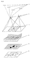
- the embodiment includes a topographical area that after Procedures are recorded, evaluated, measured and saved.
- FIG 3 the method is shown schematically in such a way that a topographical area (area) 1 by aerial photography by plane 2, whose position in space is positioned by satellites 3 with the help of their signals (DGPS) is included; then the digital elevation model 4 after the fourth process step is derived or calculated as data evaluation, becomes from the topographical area (area) 1 and from the digital elevation model 4 including the known location of the projection centers in space at the time of the recording by the aircraft 2 and by means of mathematical Transformation from an analog aerial photo or from a digital aerial photo scene created the digital Orthophoto 5, which the potential user uses a data carrier is made available, with which the potential user according to his Task and necessary decision making, which he as the client the digital orthophoto 5 add a vector, line graphic 6 and evaluate it accordingly.
- DGPS signals
Landscapes
- Engineering & Computer Science (AREA)
- Multimedia (AREA)
- Physics & Mathematics (AREA)
- General Physics & Mathematics (AREA)
- Radar, Positioning & Navigation (AREA)
- Remote Sensing (AREA)
- Image Processing (AREA)
- Processing Or Creating Images (AREA)
- Arrangements For Transmission Of Measured Signals (AREA)
- Geophysics And Detection Of Objects (AREA)
- Navigation (AREA)
- Instructional Devices (AREA)
- Steroid Compounds (AREA)
- Recording Measured Values (AREA)
- Photoreceptors In Electrophotography (AREA)
- Investigating Or Analyzing Materials Using Thermal Means (AREA)
- Management, Administration, Business Operations System, And Electronic Commerce (AREA)
- Position Fixing By Use Of Radio Waves (AREA)
Applications Claiming Priority (3)
| Application Number | Priority Date | Filing Date | Title |
|---|---|---|---|
| DE4419359A DE4419359A1 (de) | 1994-06-03 | 1994-06-03 | Verfahren zur Erfassung, Auswertung, Ausmessung und Speicherung von Geo-Informationen |
| DE4419359 | 1994-06-03 | ||
| PCT/DE1995/000639 WO1995033973A1 (de) | 1994-06-03 | 1995-05-10 | Verfahren zur erfassung, auswertung, ausmessung und speicherung von geo-informationen |
Publications (2)
| Publication Number | Publication Date |
|---|---|
| EP0763185A1 EP0763185A1 (de) | 1997-03-19 |
| EP0763185B1 true EP0763185B1 (de) | 2000-11-22 |
Family
ID=6519662
Family Applications (1)
| Application Number | Title | Priority Date | Filing Date |
|---|---|---|---|
| EP95919309A Expired - Lifetime EP0763185B1 (de) | 1994-06-03 | 1995-05-10 | Verfahren zur erfassung, auswertung, ausmessung und speicherung von geo-informationen |
Country Status (18)
| Country | Link |
|---|---|
| EP (1) | EP0763185B1 (es) |
| CN (1) | CN1149916A (es) |
| AT (1) | ATE197736T1 (es) |
| AU (1) | AU3858795A (es) |
| CA (1) | CA2191954A1 (es) |
| CZ (1) | CZ341696A3 (es) |
| DE (2) | DE4419359A1 (es) |
| DK (1) | DK0763185T3 (es) |
| EE (1) | EE9600200A (es) |
| ES (1) | ES2099055T3 (es) |
| GE (1) | GEP20002247B (es) |
| GR (1) | GR970300018T1 (es) |
| HU (1) | HUT76229A (es) |
| LT (1) | LT4215B (es) |
| LV (1) | LV11712B (es) |
| PE (1) | PE28996A1 (es) |
| PL (1) | PL317417A1 (es) |
| WO (1) | WO1995033973A1 (es) |
Families Citing this family (42)
| Publication number | Priority date | Publication date | Assignee | Title |
|---|---|---|---|---|
| US6442293B1 (en) | 1998-06-11 | 2002-08-27 | Kabushiki Kaisha Topcon | Image forming apparatus, image forming method and computer-readable storage medium having an image forming program |
| DE19857667A1 (de) * | 1998-12-15 | 2000-08-17 | Aerowest Photogrammetrie H Ben | Verfahren zur Erzeugung einer drei-dimensionalen Objektbeschreibung |
| IE990827A1 (en) * | 1999-10-04 | 2001-04-18 | Digitech Res | Production of a survey animated digital model |
| US6810153B2 (en) * | 2002-03-20 | 2004-10-26 | Hitachi Software Global Technology, Ltd. | Method for orthocorrecting satellite-acquired image |
| US6833811B2 (en) * | 2002-10-07 | 2004-12-21 | Harris Corporation | System and method for highly accurate real time tracking and location in three dimensions |
| CN1303431C (zh) * | 2002-12-13 | 2007-03-07 | 中国科学院电子学研究所 | 机载合成孔径雷达测量区域定位系统 |
| US7800645B2 (en) * | 2003-06-20 | 2010-09-21 | Mitsubishi Denki Kabushiki Kaisha | Image display method and image display apparatus |
| CN100451544C (zh) * | 2004-03-15 | 2009-01-14 | 清华大学 | 一种基于视频图像测量飞行器姿态参数的方法 |
| US7298891B2 (en) * | 2004-07-15 | 2007-11-20 | Harris Corporation | Bare earth digital elevation model extraction for three-dimensional registration from topographical points |
| WO2007041756A1 (en) * | 2005-10-11 | 2007-04-19 | Data Info Tech Pty Ltd | A survey device |
| NZ564154A (en) | 2005-10-11 | 2011-02-25 | Data Info Tech Pty Ltd | A survey device |
| CN101162265B (zh) * | 2006-10-12 | 2011-03-23 | 华晶科技股份有限公司 | 卫星定位记录装置及记录方法 |
| CN101051082B (zh) * | 2007-03-30 | 2010-05-19 | 清华大学 | 对全部原始雷达信息打包处理的方法 |
| US8078436B2 (en) | 2007-04-17 | 2011-12-13 | Eagle View Technologies, Inc. | Aerial roof estimation systems and methods |
| US8145578B2 (en) | 2007-04-17 | 2012-03-27 | Eagel View Technologies, Inc. | Aerial roof estimation system and method |
| JP4492654B2 (ja) * | 2007-08-29 | 2010-06-30 | オムロン株式会社 | 3次元計測方法および3次元計測装置 |
| CN101304408B (zh) * | 2008-06-03 | 2010-11-03 | 中国航天时代电子公司第七七一研究所 | 一种遥感卫星载荷数据的处理方法 |
| US8209152B2 (en) | 2008-10-31 | 2012-06-26 | Eagleview Technologies, Inc. | Concurrent display systems and methods for aerial roof estimation |
| US8170840B2 (en) | 2008-10-31 | 2012-05-01 | Eagle View Technologies, Inc. | Pitch determination systems and methods for aerial roof estimation |
| US8731234B1 (en) | 2008-10-31 | 2014-05-20 | Eagle View Technologies, Inc. | Automated roof identification systems and methods |
| AU2011210538B2 (en) | 2010-02-01 | 2015-03-26 | Eagle View Technologies, Inc. | Geometric correction of rough wireframe models derived from photographs |
| EP2527787B1 (en) * | 2011-05-23 | 2019-09-11 | Kabushiki Kaisha TOPCON | Aerial photograph image pickup method and aerial photograph image pickup apparatus |
| US10515414B2 (en) | 2012-02-03 | 2019-12-24 | Eagle View Technologies, Inc. | Systems and methods for performing a risk management assessment of a property |
| US10663294B2 (en) | 2012-02-03 | 2020-05-26 | Eagle View Technologies, Inc. | Systems and methods for estimation of building wall area and producing a wall estimation report |
| US8774525B2 (en) | 2012-02-03 | 2014-07-08 | Eagle View Technologies, Inc. | Systems and methods for estimation of building floor area |
| US9933257B2 (en) | 2012-02-03 | 2018-04-03 | Eagle View Technologies, Inc. | Systems and methods for estimation of building wall area |
| US9599466B2 (en) | 2012-02-03 | 2017-03-21 | Eagle View Technologies, Inc. | Systems and methods for estimation of building wall area |
| US9501700B2 (en) | 2012-02-15 | 2016-11-22 | Xactware Solutions, Inc. | System and method for construction estimation using aerial images |
| US11587176B2 (en) | 2013-03-15 | 2023-02-21 | Eagle View Technologies, Inc. | Price estimation model |
| US10909482B2 (en) | 2013-03-15 | 2021-02-02 | Pictometry International Corp. | Building materials estimation |
| US9959581B2 (en) | 2013-03-15 | 2018-05-01 | Eagle View Technologies, Inc. | Property management on a smartphone |
| EP3028464B1 (en) | 2013-08-02 | 2019-05-01 | Xactware Solutions Inc. | System and method for detecting features in aerial images using disparity mapping and segmentation techniques |
| CN104637370B (zh) * | 2014-12-23 | 2015-11-25 | 河南城建学院 | 一种摄影测量与遥感综合教学的方法及系统 |
| RU174052U1 (ru) * | 2015-12-30 | 2017-09-27 | Федеральное государственное бюджетное образовательное учреждение высшего профессионального образования "Рязанский государственный радиотехнический университет" | Программно-аппаратный комплекс мониторинга состояния воздушных линий электропередач |
| RU2667793C1 (ru) * | 2017-07-21 | 2018-09-24 | Закрытое акционерное общество "ИНТЕГРА-С" | Геоинформационная система в формате 4d |
| US10503843B2 (en) | 2017-12-19 | 2019-12-10 | Eagle View Technologies, Inc. | Supervised automatic roof modeling |
| RU2699940C1 (ru) * | 2018-11-23 | 2019-09-11 | Публичное акционерное общество "Транснефть" (ПАО "Транснефть") | Способ мониторинга состояния трассы магистрального трубопровода |
| CN111984026A (zh) * | 2019-05-23 | 2020-11-24 | 广州极飞科技有限公司 | 无人机的控制方法和装置 |
| CN110440762B (zh) * | 2019-09-18 | 2022-05-03 | 中国电建集团贵州电力设计研究院有限公司 | 一种多旋翼无人机山区航测成图的网格化像控点布设方法 |
| CN110487251B (zh) * | 2019-09-18 | 2022-05-03 | 中国电建集团贵州电力设计研究院有限公司 | 一种用非量测相机的无人机进行大比例尺测图的作业方法 |
| US11094113B2 (en) | 2019-12-04 | 2021-08-17 | Geomni, Inc. | Systems and methods for modeling structures using point clouds derived from stereoscopic image pairs |
| CN111192366B (zh) * | 2019-12-30 | 2023-04-07 | 重庆市勘测院 | 用于建筑高度三维控制的方法及装置、服务器 |
Citations (8)
| Publication number | Priority date | Publication date | Assignee | Title |
|---|---|---|---|---|
| DE3219032A1 (de) * | 1982-05-19 | 1983-11-24 | Messerschmitt-Bölkow-Blohm GmbH, 8000 München | Stereophotogrammetrisches aufnahme- und auswerteverfahren sowie auswertevorrichtung |
| DE3612674A1 (de) * | 1985-04-15 | 1986-10-16 | Carson Helicopters, Inc., Perkasie, Pa. | Verfahren zur schwerkraftvermessung aus der luft |
| EP0237601A1 (de) * | 1986-03-19 | 1987-09-23 | Rollei Fototechnic GmbH | Verfahren zur photogrammetrischen Erfassung eines Objektes mit Hilfe zumindest eines opto-elektrischen Festkörper-Flächensensors |
| WO1990000719A1 (de) * | 1988-07-06 | 1990-01-25 | Wild Leitz Ag | Vermessungssystem mit einer elektrooptischen totalstation und einer mobilen empfangsstation eines satelliten-positionsmess-systems |
| EP0379198A2 (en) * | 1989-01-18 | 1990-07-25 | Sharp Kabushiki Kaisha | Mobile object navigation system |
| EP0408179A2 (en) * | 1989-07-14 | 1991-01-16 | General Atomics | Integrated automated system for waste site characterization |
| EP0545636A1 (en) * | 1991-11-29 | 1993-06-09 | Navsys Corporation | GPS tracking system |
| DE4301875A1 (en) * | 1992-01-22 | 1993-08-12 | Mitsubishi Electric Corp | Road traffic navigation system with detour route function - comprises computer controlled system with facility to establish main and secondary routes |
Family Cites Families (6)
| Publication number | Priority date | Publication date | Assignee | Title |
|---|---|---|---|---|
| DE237211C (es) | ||||
| US4635203A (en) * | 1984-04-06 | 1987-01-06 | Honeywell Inc. | Passive range measurement apparatus and method |
| DE3830577C3 (de) | 1988-09-08 | 1995-02-23 | Deutsche Aerospace | Digitale Abtastung |
| DE3802541A1 (de) * | 1988-01-28 | 1989-08-10 | Von Braun H Dr Schmidt | Grossmassstaebliches kartieren von parametern mehrdimensionaler strukturen in naturraeumen |
| DE3935244A1 (de) * | 1989-10-23 | 1991-04-25 | Von Braun Heiko Dr Schmidt | Verfahren zur erkundung von strukturen im naturraum aus der luft |
| DE4216828C2 (de) * | 1992-05-21 | 1994-08-18 | Dornier Gmbh | Verfahren zur Erdbeobachtung |
-
1994
- 1994-06-03 DE DE4419359A patent/DE4419359A1/de not_active Withdrawn
-
1995
- 1995-05-10 GE GEAP19953456A patent/GEP20002247B/en unknown
- 1995-05-10 ES ES95919309T patent/ES2099055T3/es not_active Expired - Lifetime
- 1995-05-10 WO PCT/DE1995/000639 patent/WO1995033973A1/de active IP Right Grant
- 1995-05-10 CA CA002191954A patent/CA2191954A1/en not_active Abandoned
- 1995-05-10 DK DK95919309T patent/DK0763185T3/da active
- 1995-05-10 PL PL95317417A patent/PL317417A1/xx unknown
- 1995-05-10 HU HU9603288A patent/HUT76229A/hu unknown
- 1995-05-10 CZ CZ963416A patent/CZ341696A3/cs unknown
- 1995-05-10 AU AU38587/95A patent/AU3858795A/en not_active Abandoned
- 1995-05-10 AT AT95919309T patent/ATE197736T1/de active
- 1995-05-10 CN CN95193407A patent/CN1149916A/zh active Pending
- 1995-05-10 EE EE9600200A patent/EE9600200A/xx unknown
- 1995-05-10 DE DE59508871T patent/DE59508871D1/de not_active Expired - Lifetime
- 1995-05-10 EP EP95919309A patent/EP0763185B1/de not_active Expired - Lifetime
- 1995-06-02 PE PE1995270300A patent/PE28996A1/es not_active Application Discontinuation
-
1996
- 1996-11-27 LT LT96-166A patent/LT4215B/lt not_active IP Right Cessation
- 1996-11-28 LV LVP-96-443A patent/LV11712B/lv unknown
-
1997
- 1997-06-30 GR GR970300018T patent/GR970300018T1/el unknown
Patent Citations (8)
| Publication number | Priority date | Publication date | Assignee | Title |
|---|---|---|---|---|
| DE3219032A1 (de) * | 1982-05-19 | 1983-11-24 | Messerschmitt-Bölkow-Blohm GmbH, 8000 München | Stereophotogrammetrisches aufnahme- und auswerteverfahren sowie auswertevorrichtung |
| DE3612674A1 (de) * | 1985-04-15 | 1986-10-16 | Carson Helicopters, Inc., Perkasie, Pa. | Verfahren zur schwerkraftvermessung aus der luft |
| EP0237601A1 (de) * | 1986-03-19 | 1987-09-23 | Rollei Fototechnic GmbH | Verfahren zur photogrammetrischen Erfassung eines Objektes mit Hilfe zumindest eines opto-elektrischen Festkörper-Flächensensors |
| WO1990000719A1 (de) * | 1988-07-06 | 1990-01-25 | Wild Leitz Ag | Vermessungssystem mit einer elektrooptischen totalstation und einer mobilen empfangsstation eines satelliten-positionsmess-systems |
| EP0379198A2 (en) * | 1989-01-18 | 1990-07-25 | Sharp Kabushiki Kaisha | Mobile object navigation system |
| EP0408179A2 (en) * | 1989-07-14 | 1991-01-16 | General Atomics | Integrated automated system for waste site characterization |
| EP0545636A1 (en) * | 1991-11-29 | 1993-06-09 | Navsys Corporation | GPS tracking system |
| DE4301875A1 (en) * | 1992-01-22 | 1993-08-12 | Mitsubishi Electric Corp | Road traffic navigation system with detour route function - comprises computer controlled system with facility to establish main and secondary routes |
Non-Patent Citations (3)
| Title |
|---|
| B.F. Kavanagh & S.J. Glenn Bird: "Surveying, Principles and Applications"; 1984, Reston Publishing Company, USA; Seiten 467 bis 471 * |
| GIS Zeitschrift 4/1993, J. Höhle: "Height Models and Digital Orthophotos in GIS"; Seiten 17 bis 22 * |
| PHOTOGRAMMETRIC ENGINEERING AND REMOTE SENSING, vol. 51, no. 4, April 1985; Seiten 445 bis 454; O.O. Ayeni: "Photogrammetry as a Tool for National Development" * |
Also Published As
| Publication number | Publication date |
|---|---|
| HU9603288D0 (en) | 1997-01-28 |
| EP0763185A1 (de) | 1997-03-19 |
| CN1149916A (zh) | 1997-05-14 |
| CZ341696A3 (en) | 1997-03-12 |
| DE59508871D1 (de) | 2000-12-28 |
| LV11712A (lv) | 1997-02-20 |
| LT4215B (en) | 1997-09-25 |
| DE4419359A1 (de) | 1995-12-07 |
| ATE197736T1 (de) | 2000-12-15 |
| EE9600200A (et) | 1997-06-16 |
| AU3858795A (en) | 1996-01-04 |
| HUT76229A (en) | 1997-07-28 |
| CA2191954A1 (en) | 1995-12-14 |
| ES2099055T3 (es) | 2001-02-01 |
| LV11712B (en) | 1997-06-20 |
| GR970300018T1 (en) | 1997-06-30 |
| DK0763185T3 (da) | 2001-03-19 |
| WO1995033973A1 (de) | 1995-12-14 |
| LT96166A (en) | 1997-07-25 |
| PL317417A1 (en) | 1997-04-14 |
| PE28996A1 (es) | 1996-07-24 |
| ES2099055T1 (es) | 1997-05-16 |
| GEP20002247B (en) | 2000-09-25 |
Similar Documents
| Publication | Publication Date | Title |
|---|---|---|
| EP0763185B1 (de) | Verfahren zur erfassung, auswertung, ausmessung und speicherung von geo-informationen | |
| Koeva et al. | Using UAVs for map creation and updating. A case study in Rwanda | |
| EP1010966B1 (de) | Verfahren zur Erzeugung einer drei-dimensionalen Objektbeschreibung | |
| CN111597666B (zh) | 一种将bim应用到变电站建设过程的方法 | |
| DE69532126T2 (de) | Verfahren zum sammeln und verarbeiten visueller und räumlicher positionsinformation | |
| CN110362895B (zh) | 一种基于bim+gis技术的征地拆迁应用管理系统 | |
| EP4051982A1 (de) | Verfahren und mobile erfassungsvorrichtung zur erfassung von infrastrukturelementen eines unterirdischen leitungsnetzwerks | |
| EP3228980A1 (de) | Schichtdickenmessung von erdabdeckungen | |
| Ahmed et al. | Potentiality of high-resolution topographic survey using unmanned aerial vehicle in Bangladesh | |
| EP0634628B1 (de) | Verfahren zur Erdbeobachtung | |
| DE102004028736A1 (de) | Verfahren zur automatischen Erfassung und Bestimmung von ortsfesten Objekten im Freien von einem fahrenden Fahrzeug aus | |
| Norton-Griffiths | Aerial point sampling for land use surveys | |
| Cera et al. | Evaluating the potential of imaging rover for automatic point cloud generation | |
| DE19719620A1 (de) | Verfahren zur Erstellung, Bearbeitung und Nutzung von Luftaufnahmen | |
| Osborn et al. | National digital elevation program (NDEP) | |
| Bezmenov et al. | Application of unmanned aerial vehicles for solving engineering tasks | |
| Chandler et al. | Analytical photogrammetry applied to Nepalese slope morphology | |
| Vote | A new methodology for archaeological analysis: Using visualization and interaction to explore spatial links in excavation data | |
| Yastikli et al. | Automatic digital elevation model generation, problems and restrictions in urban areas | |
| LU504675B1 (de) | Ein verfahren zur gewinnung von informationen über die erdrutschgefahr auf der grundlage von uav-bilddaten in hochgebirgstalgebieten | |
| Vasiukhin et al. | The aggregation technology of applied software for aerial photography data processing to building map databases in precision agriculture system | |
| Rezaldi et al. | Improving the Quality of 3D Orthomosaic Images by Increasing Close Range Photogrammetry (CRP) and Data Processing | |
| Howard et al. | Mapping Small-Scale Mining Sites in Wassa Amenfi East Area of Ghana | |
| Howland et al. | APPS-IV Civil Works Data Extraction/Data Base Application Study | |
| KALE et al. | INTEGRATION 3D MODEL WITH GIS |
Legal Events
| Date | Code | Title | Description |
|---|---|---|---|
| PUAI | Public reference made under article 153(3) epc to a published international application that has entered the european phase |
Free format text: ORIGINAL CODE: 0009012 |
|
| 17P | Request for examination filed |
Effective date: 19961202 |
|
| AK | Designated contracting states |
Kind code of ref document: A1 Designated state(s): AT CH DE DK ES FR GR IT LI NL PT |
|
| ITCL | It: translation for ep claims filed |
Representative=s name: JACOBACCI CASETTA & PERANI S.P.A. |
|
| EL | Fr: translation of claims filed | ||
| REG | Reference to a national code |
Ref country code: ES Ref legal event code: BA2A Ref document number: 2099055 Country of ref document: ES Kind code of ref document: T1 |
|
| 17Q | First examination report despatched |
Effective date: 19970430 |
|
| TCNL | Nl: translation of patent claims filed | ||
| APAB | Appeal dossier modified |
Free format text: ORIGINAL CODE: EPIDOS NOAPE |
|
| APAD | Appeal reference recorded |
Free format text: ORIGINAL CODE: EPIDOS REFNE |
|
| APAB | Appeal dossier modified |
Free format text: ORIGINAL CODE: EPIDOS NOAPE |
|
| RBV | Designated contracting states (corrected) |
Designated state(s): AT CH DE DK ES FR GR IT LI NL PT |
|
| GRAG | Despatch of communication of intention to grant |
Free format text: ORIGINAL CODE: EPIDOS AGRA |
|
| GRAG | Despatch of communication of intention to grant |
Free format text: ORIGINAL CODE: EPIDOS AGRA |
|
| GRAH | Despatch of communication of intention to grant a patent |
Free format text: ORIGINAL CODE: EPIDOS IGRA |
|
| GRAH | Despatch of communication of intention to grant a patent |
Free format text: ORIGINAL CODE: EPIDOS IGRA |
|
| GRAA | (expected) grant |
Free format text: ORIGINAL CODE: 0009210 |
|
| AK | Designated contracting states |
Kind code of ref document: B1 Designated state(s): AT CH DE DK ES FR GR IT LI NL PT |
|
| PG25 | Lapsed in a contracting state [announced via postgrant information from national office to epo] |
Ref country code: NL Free format text: LAPSE BECAUSE OF FAILURE TO SUBMIT A TRANSLATION OF THE DESCRIPTION OR TO PAY THE FEE WITHIN THE PRESCRIBED TIME-LIMIT Effective date: 20001122 Ref country code: GR Free format text: LAPSE BECAUSE OF NON-PAYMENT OF DUE FEES Effective date: 20001122 |
|
| REF | Corresponds to: |
Ref document number: 197736 Country of ref document: AT Date of ref document: 20001215 Kind code of ref document: T |
|
| ITF | It: translation for a ep patent filed |
Owner name: JACOBACCI & PERANI S.P.A. |
|
| REG | Reference to a national code |
Ref country code: CH Ref legal event code: NV Representative=s name: PATENTANWALTSBUERO ZINK Ref country code: CH Ref legal event code: EP |
|
| REF | Corresponds to: |
Ref document number: 59508871 Country of ref document: DE Date of ref document: 20001228 |
|
| ET | Fr: translation filed | ||
| REG | Reference to a national code |
Ref country code: ES Ref legal event code: FG2A Ref document number: 2099055 Country of ref document: ES Kind code of ref document: T3 |
|
| PG25 | Lapsed in a contracting state [announced via postgrant information from national office to epo] |
Ref country code: PT Free format text: LAPSE BECAUSE OF FAILURE TO SUBMIT A TRANSLATION OF THE DESCRIPTION OR TO PAY THE FEE WITHIN THE PRESCRIBED TIME-LIMIT Effective date: 20010222 |
|
| REG | Reference to a national code |
Ref country code: DK Ref legal event code: T3 |
|
| NLV1 | Nl: lapsed or annulled due to failure to fulfill the requirements of art. 29p and 29m of the patents act | ||
| PLBE | No opposition filed within time limit |
Free format text: ORIGINAL CODE: 0009261 |
|
| STAA | Information on the status of an ep patent application or granted ep patent |
Free format text: STATUS: NO OPPOSITION FILED WITHIN TIME LIMIT |
|
| 26N | No opposition filed | ||
| PGFP | Annual fee paid to national office [announced via postgrant information from national office to epo] |
Ref country code: CH Payment date: 20040402 Year of fee payment: 10 |
|
| PG25 | Lapsed in a contracting state [announced via postgrant information from national office to epo] |
Ref country code: LI Free format text: LAPSE BECAUSE OF NON-PAYMENT OF DUE FEES Effective date: 20050531 Ref country code: CH Free format text: LAPSE BECAUSE OF NON-PAYMENT OF DUE FEES Effective date: 20050531 |
|
| APAH | Appeal reference modified |
Free format text: ORIGINAL CODE: EPIDOSCREFNO |
|
| REG | Reference to a national code |
Ref country code: CH Ref legal event code: PL |
|
| PGFP | Annual fee paid to national office [announced via postgrant information from national office to epo] |
Ref country code: ES Payment date: 20110411 Year of fee payment: 17 Ref country code: FR Payment date: 20110610 Year of fee payment: 17 |
|
| PGFP | Annual fee paid to national office [announced via postgrant information from national office to epo] |
Ref country code: DK Payment date: 20110525 Year of fee payment: 17 Ref country code: AT Payment date: 20110503 Year of fee payment: 17 |
|
| PGFP | Annual fee paid to national office [announced via postgrant information from national office to epo] |
Ref country code: IT Payment date: 20110514 Year of fee payment: 17 |
|
| REG | Reference to a national code |
Ref country code: AT Ref legal event code: MM01 Ref document number: 197736 Country of ref document: AT Kind code of ref document: T Effective date: 20120510 |
|
| REG | Reference to a national code |
Ref country code: DK Ref legal event code: EBP |
|
| PG25 | Lapsed in a contracting state [announced via postgrant information from national office to epo] |
Ref country code: AT Free format text: LAPSE BECAUSE OF NON-PAYMENT OF DUE FEES Effective date: 20120510 |
|
| PG25 | Lapsed in a contracting state [announced via postgrant information from national office to epo] |
Ref country code: IT Free format text: LAPSE BECAUSE OF NON-PAYMENT OF DUE FEES Effective date: 20120510 |
|
| REG | Reference to a national code |
Ref country code: FR Ref legal event code: ST Effective date: 20130131 |
|
| PG25 | Lapsed in a contracting state [announced via postgrant information from national office to epo] |
Ref country code: DK Free format text: LAPSE BECAUSE OF NON-PAYMENT OF DUE FEES Effective date: 20120531 Ref country code: FR Free format text: LAPSE BECAUSE OF NON-PAYMENT OF DUE FEES Effective date: 20120531 |
|
| PGFP | Annual fee paid to national office [announced via postgrant information from national office to epo] |
Ref country code: DE Payment date: 20130624 Year of fee payment: 19 |
|
| REG | Reference to a national code |
Ref country code: ES Ref legal event code: FD2A Effective date: 20130821 |
|
| PG25 | Lapsed in a contracting state [announced via postgrant information from national office to epo] |
Ref country code: ES Free format text: LAPSE BECAUSE OF NON-PAYMENT OF DUE FEES Effective date: 20120511 |
|
| REG | Reference to a national code |
Ref country code: DE Ref legal event code: R119 Ref document number: 59508871 Country of ref document: DE |
|
| REG | Reference to a national code |
Ref country code: DE Ref legal event code: R119 Ref document number: 59508871 Country of ref document: DE Effective date: 20141202 |
|
| PG25 | Lapsed in a contracting state [announced via postgrant information from national office to epo] |
Ref country code: DE Free format text: LAPSE BECAUSE OF NON-PAYMENT OF DUE FEES Effective date: 20141202 |