EP3051258A2 - Determination of a route using a first and a second navigation device - Google Patents
Determination of a route using a first and a second navigation device Download PDFInfo
- Publication number
- EP3051258A2 EP3051258A2 EP16020021.8A EP16020021A EP3051258A2 EP 3051258 A2 EP3051258 A2 EP 3051258A2 EP 16020021 A EP16020021 A EP 16020021A EP 3051258 A2 EP3051258 A2 EP 3051258A2
- Authority
- EP
- European Patent Office
- Prior art keywords
- route
- navigation device
- vehicle
- unit
- navigation
- Prior art date
- Legal status (The legal status is an assumption and is not a legal conclusion. Google has not performed a legal analysis and makes no representation as to the accuracy of the status listed.)
- Granted
Links
- 238000000034 method Methods 0.000 claims abstract description 39
- 230000005540 biological transmission Effects 0.000 claims abstract description 29
- 230000003213 activating effect Effects 0.000 claims description 2
- 230000015654 memory Effects 0.000 description 20
- 230000006870 function Effects 0.000 description 8
- 230000000694 effects Effects 0.000 description 5
- 230000002457 bidirectional effect Effects 0.000 description 2
- 238000010586 diagram Methods 0.000 description 2
- 238000012790 confirmation Methods 0.000 description 1
- 230000001419 dependent effect Effects 0.000 description 1
- 239000000446 fuel Substances 0.000 description 1
- 238000004904 shortening Methods 0.000 description 1
- 230000001960 triggered effect Effects 0.000 description 1
- 230000000007 visual effect Effects 0.000 description 1
Images


Classifications
-
- G—PHYSICS
- G01—MEASURING; TESTING
- G01C—MEASURING DISTANCES, LEVELS OR BEARINGS; SURVEYING; NAVIGATION; GYROSCOPIC INSTRUMENTS; PHOTOGRAMMETRY OR VIDEOGRAMMETRY
- G01C21/00—Navigation; Navigational instruments not provided for in groups G01C1/00 - G01C19/00
- G01C21/26—Navigation; Navigational instruments not provided for in groups G01C1/00 - G01C19/00 specially adapted for navigation in a road network
- G01C21/34—Route searching; Route guidance
- G01C21/3407—Route searching; Route guidance specially adapted for specific applications
- G01C21/3438—Rendez-vous, i.e. searching a destination where several users can meet, and the routes to this destination for these users; Ride sharing, i.e. searching a route such that at least two users can share a vehicle for at least part of the route
Definitions
- the invention relates to a method for determining a route using a first navigation device and a second navigation device and a navigation system having a first navigation device and a second navigation device for carrying out the method.
- a conventional navigation device is capable of calculating a route that leads from a current position of the navigation device to a destination position.
- the position of the navigation device is usually determined using a satellite navigation system, for example by means of GPS, GLONASS, COMPASS or GALILEO.
- the target position is usually derived from a target that inputs a user of the navigation device via an operating unit in the navigation device.
- the destination position may also be estimated, for example from a driving history.
- the route can be calculated using a computing unit of the navigation device.
- map data are used, which are usually stored in a non-volatile memory unit of the navigation device, for example on a CD-ROM, on a hard disk or in a flash memory.
- the map data represents geographic objects and associated information such as roads, paths, squares, railways, rivers, buildings, bridges, terrain, national boundaries, parking, rest areas, localities, traffic regulations, and speed limits.
- the arithmetic unit can also be used for other tasks, for example for displaying graphics on a touch screen of the navigation device.
- the route or a section of the route can be displayed on a screen associated with the navigation device. This allows the user to develop a spatial idea of the route or of a route section ahead of it. This allows the user, for example, to plan driving maneuvers with foresight.
- a route guidance can be started after the route calculation.
- Guidance is a process that guides the user along the route.
- the navigation device indicates visual and / or acoustic driving instructions the user off.
- the driving instructions are generated by the computing unit in consideration of the route, the map data and a current position of the navigation device and output to the user using an output unit of the navigation device.
- leader vehicle If a vehicle or vehicles in a vehicle convoy is following a leader vehicle, there is a risk that the driver of a following vehicle ("follower vehicle”) will lose sight of the leader vehicle. This can lead, inter alia, to the following vehicle not reaching a common destination of the vehicle crew in time or not.
- a current position of the leading vehicle may be transmitted to the following vehicle, so that the following vehicle is enabled to follow the leading vehicle.
- a route is calculated on board the follower vehicle, which runs from the position of the follower vehicle to the position of the leading vehicle. Based on the route, driving instructions are generated for the driver of the following vehicle, with the help of which the driver can control the following vehicle to the position of the leading vehicle.
- the position of the follower vehicle may be transmitted to the leader vehicle.
- a route is calculated on board the leading vehicle, which runs from the position of the following vehicle to the position of the leading vehicle.
- the route is transmitted to the follower vehicle where, based on the route, driving instructions are generated for the driver of the follower vehicle, with the aid of which the driver can control the following vehicle to the position of the leading vehicle.
- Both alternatives each require a complex calculation of a route which connects the position of the follower vehicle with the position of the leading vehicle.
- the calculation is carried out by a computing unit of a navigation device.
- the arithmetic unit is not or only partially available for other tasks. Therefore, it seems desirable to reduce the burden of such route calculation.
- the object is achieved with the method according to the invention for determining a route using a first navigation device and a second navigation device solved.
- the first navigation device has a first position determination unit and a data transmission unit
- the second navigation device has a second position determination unit, a computing unit and a data reception unit.
- the method can be used to determine a second route, which leads from a second navigation device to a first navigation device.
- the second navigation device (or a follower vehicle equipped with a vehicle column equipped therewith) can follow the first navigation device (or a leading vehicle of the vehicle column equipped therewith).
- a route course representing the course of a first route traveled by the first navigation device is used to determine the second route.
- the course of the route can be obtained in a simple manner, namely by detecting a plurality of positions of the first navigation device, for example at specific time intervals or local distances.
- the second route runs at least partially on the first route.
- this route section can be dispensed with a complex route calculation, so that the determination of the second route in comparison to a conventional route determination requires less effort overall. This is especially true when the second navigation device is already on the first route.
- the second route can be determined as a route section of the first route, which is associated with very little effort.
- the second route, on which the follower vehicle can follow the leading vehicle can be determined with particularly little effort.
- FIG. 3 shows a block diagram of a navigation device according to an embodiment of the invention.
- FIGS. 4 and 5 each show a plan view of a route for explaining an embodiment of the method according to the invention.
- FIG. 1 shows a schematic representation of a navigation arrangement 100 according to an embodiment of the invention.
- the navigation arrangement 100 has a first navigation device 101 and a second navigation device 102.
- the first navigation device 101 is in a leading position Vehicle (leading vehicle) of a vehicle convoy built-in, while the second navigation device 102 in a vehicle of the vehicle convoy, which follows the leading vehicle (follower vehicle), is permanently installed.
- the vehicles may be passenger cars, trucks, motorcycles, bicycles, aircraft, watercraft or any other type of vehicles.
- each or one of the navigation devices 101, 102 may be stored or mounted in or on the respective vehicle so that they can be easily removed from the vehicle or from the vehicle.
- each or one of the navigation devices 101, 102 may be worn by a user on the body.
- navigation devices which are installed in further following vehicles or which are carried by additional users may belong to the navigation arrangement.
- the first navigation device 101 is configured to detect a route that represents the course of a route traveled by the first navigation device 101 from a route start position to a route end position.
- the route end position may be a current position of the first navigation device 101.
- the first navigation device 101 is able to send the route course in the form of data to the second navigation device 102.
- the second navigation device 102 is configured to receive and process the route course from the first navigation device 101.
- Transmission of a route course from the first navigation device 101 to the second navigation device 102 is described in FIG. 1 symbolized by the arrow 103.
- the transmission of the route is wireless, but can also be wired.
- the two navigation devices 101, 102 may be configured such that data can also be transmitted in the opposite direction, that is, from the second navigation device 102 to the first navigation device 101.
- FIG. 2 shows a schematic representation of a navigation arrangement 200 according to another embodiment of the invention.
- the navigation arrangement 200 has a first navigation device 201 and a second navigation device 202 which correspond to the navigation devices 101 and 102 FIG. 1 correspond. Optionally, further navigation devices may belong to the navigation arrangement.
- the navigation arrangement 200 has a server 203, which can receive data from the first navigation device 201 and send data to the second navigation device 202.
- the transmission of the data from the first navigation device 201 to the server 203 is symbolized by a first arrow 204 and the transmission of the data from the server 203 to the second navigation device 202 is symbolized by a second arrow 205.
- the server 203 may receive a route history from the first navigation device 201 and forward it to the second navigation device 202.
- the server 203 can also forward the route to other navigation devices that are installed, for example, in other following vehicles of the vehicle crew.
- the server 203 may cache and / or process a received route history, or the data representing the route history, prior to its or its forwarding.
- FIG. 3 shows a block diagram of a navigation device 300 according to an embodiment of the invention.
- the navigation device 300 is permanently installed in a vehicle.
- the navigation device may also be carried as a portable device in a vehicle or carried by a user who is traveling without a vehicle, for example on his body.
- the navigation device 300 is embodied such that it monitors the function of both the first navigation device 101, 201 and the second navigation device 102, 202 from the Figures 1 and 2 can take over.
- the navigation device 300 has the following functional modules: a position determination unit, a computing unit, a memory unit, a data transmission unit, a reception unit and an output and control unit.
- the navigation device 300 may also have further functional modules, for example an interface unit.
- the position determining unit is a GPS receiver equipped with a satellite receiving antenna in the form of a GPS antenna (not shown).
- the position determination unit may acquire position coordinates, which represent a geographical position of the navigation device 300, from satellite signals and transmit them to the arithmetic unit.
- the position determination unit is connected to the arithmetic unit via a data connection.
- a different type of position determination unit is used instead of the GPS receiver, for example a GALILEO receiver or a GLONASS receiver.
- the position determination unit is set up in particular for detecting the route course of a first route covered by the navigation device 300 up to a route end position. For this purpose, the position determination unit detects the position coordinates of a plurality of positions of the navigation device 300 and transfers them to the arithmetic unit, which stores the position coordinates in the memory unit.
- the arithmetic unit is the central control unit of the navigation device 300. It has in addition to a processor (CPU, Central Processing Unit) via a random access memory (RAM), which is used for volatile storage of variables and intermediate results.
- the processor and the main memory are combined on an integrated circuit. Alternatively, the processor and the memory may be arranged separately from each other, for example, each on a different integrated circuit.
- the arithmetic unit is capable of determining a route which leads from a start position to a destination position. Furthermore, based on a route and a current position of the navigation device 300, the arithmetic unit can generate a driving instruction and transmit the driving instruction to the output and operating unit via a data connection.
- the computing unit is capable of determining a route that leads from a current position of the navigation device 300 to a route end position that has been reached by another navigation device.
- the route is determined to be at least partially on a route traveled from the other navigation device to the route end position.
- a route is used which represents the course of the route, which was covered by the other navigation device.
- the arithmetic unit is connected to the memory unit via a bidirectional data connection.
- the memory unit has nonvolatile memory in the form of an EEPROM (Electrically Erasable Programmable Read-Only Memory).
- EEPROM Electrically Erasable Programmable Read-Only Memory
- the memory unit may also have a different memory, for example a flash EEPROM or a hard disk.
- the memory unit can have a plurality of said memories.
- a map database containing a plurality of map data is stored in the memory unit.
- the map data represents objects that are located in a specific geographical area.
- the objects include roads, paths, squares, railway lines, rivers, buildings, bridges, terrain, national borders, parking facilities, rest areas, traffic regulations and localities.
- positions of the navigation device 300 in the form of position coordinates can be stored in the memory unit.
- the arithmetic unit is connected to the data transmission unit via a data connection.
- the data transmission unit can send data wirelessly to another navigation device or to a server, for example via a radio link.
- the data transmission unit is equipped with a suitable transmission antenna, for example with a mobile radio antenna.
- the data includes in particular a route course which represents the course of a route traveled by the navigation device 300.
- the data transmission unit transmits said data to the other navigation device in a different manner, for example by wire.
- the arithmetic unit is connected to the data receiving unit via a data connection.
- the data reception unit may receive data wirelessly from another navigation device or from a server, for example via a radio link.
- the data transmission unit is equipped with a suitable receiving antenna, for example with a mobile radio antenna.
- the data includes in particular a route course which represents the course of a route traveled by the other navigation device.
- the data receiving unit receives the data, in particular the route course, in a different way, for example by wire.
- the data reception unit may be combined with the data transmission unit in a data transmission and reception module.
- the transmitting antenna and the receiving antenna may also be combined in a transmitting and receiving antenna.
- the arithmetic unit is connected via a bidirectional data connection with the output and control unit.
- the output and operation unit includes, among other things, a touch screen, a keypad, a voice output device with a speaker, and a voice input device with a microphone.
- the output and operation unit is used inter alia for outputting environment information, route information and driving instructions to a user of the navigation device 300 and for inputting operation commands and destinations into the navigation device 300 by the user.
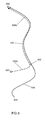
- FIG. 4 shows a plan view of a first route 401 for explaining an embodiment of the method according to the invention.
- the method is carried out using a navigation arrangement comprising a first navigation device and a second navigation device.
- the first navigation device is installed in a leading vehicle of a vehicle convoy and, in terms of its function and structure, corresponds to the navigation device 300 explained above.
- the first navigation device has inter alia a position determination unit and a data transmission unit.
- the second navigation device is installed in another vehicle of the vehicle column, which follows the leading vehicle and is therefore referred to as a "follower vehicle".
- the second navigation device also corresponds in terms of its function and structure to the navigation device 300 explained above.
- the second navigation device has, inter alia, a position determination unit, a computing unit and a data reception unit.
- a route course of the first route 401 traveled by the first navigation device until reaching a route end position 402 is detected using the position determination unit of the first navigation device.
- the route is represented by m positions where the first navigation device is at different times, where m is an integer and can be fixed.
- m is an integer and can be fixed.
- Such a position is using the Position determining unit always determined when the first navigation device has covered a route section of a certain length. Alternatively, such a position may be determined whenever a certain amount of time has passed.
- such a position can always be determined when the first navigation device has reached a junction or a base point of a road network.
- the position determination unit transmits each of the determined positions in the form of position coordinates to the arithmetic unit of the first navigation device.
- the arithmetic unit transmits the positions to the memory unit of the first navigation device, where the positions are stored.
- m and n are each an integer, where m has a value of 300 and n has a value of 60. Alternatively, m and n may also take other values, for example 100 and 20 or 600 and 60. If one of the positions satisfies criteria (a) and (b), the position is identified by the computing unit as a route end position.
- a position reached by the first navigation device is identified as the route end position 402.
- the route end position 402 and the positions m-1 previously detected represent the route route of the first route 401.
- the route course of the first route 401 is transmitted from the first navigation device to the second navigation device using the data transmission unit of the first navigation device and the data reception unit of the second navigation device.
- the arithmetic unit reads out the route end position and the positions m-1 previously determined from the memory unit and transmits the read-out positions to the data transmission unit. Further, the data transmission unit sends the positions to the Data reception unit of the second navigation device, for example via a radio link.
- the route end position and the positions m-1 previously determined are transmitted together in a data packet to the second navigation device after one of the positions has been identified as the route end position.
- each of said positions may be transmitted separately to the second navigation device immediately after the respective position has been determined.
- the second navigation device can determine a route on which the second navigation device can follow the first navigation device.
- the data transmission unit first transmits the positions to a server, which then forwards the positions to the second navigation device.
- further information about the server can be forwarded to the second navigation device, for example the name of a driver, a destination, a route, a vehicle speed, a fuel remaining quantity, an intermediate destination and / or a request to follow the leading vehicle.
- a transmission of such information is also possible in the opposite direction, that is from the second navigation device to the first navigation device.
- one or more of the information may be displayed on a vehicle-related basis using the output and operating unit of the receiving navigation device, for example in the form of a list.
- a list can be displayed Bespiel Beside a symbol of the respective vehicle in a map display.
- the first navigation device can transmit a request to the second navigation device that the following vehicle should follow the leading vehicle.
- the transmission of the request can be triggered automatically or manually by means of a corresponding input of the driver of the leading vehicle into the first navigation device.
- the driver of the follower vehicle can accept the request by a corresponding input to the second navigation device. That is, the driver of the following vehicle confirms that he wants to comply with the request.
- the confirmation may be sent to the first navigation device and displayed to the driver of the leading vehicle.
- the others Procedural steps are executed only if the request was accepted by the follower vehicle or by the driver of the follower vehicle.
- the first navigation device can transmit a point of interest (POI: point of interest) to the second navigation device in addition to the route course.
- a point indicates, for example, a danger point or a speed measuring device.
- the point can be generated manually by the driver of the leading vehicle making an input to the first navigation device while driving, for example in the form of a keystroke or in the form of a touch of his touchscreen.
- the point may also be generated automatically, for example by activating a driver assistance system or a safety system of the lead vehicle or other vehicle, for example an anti-lock braking system or an electronic stability program.
- a current position 403 of the second navigation device is determined using the position determination unit.
- the position determination unit transmits the determined position 403, which is arranged on the first route 401, in the form of position coordinates to the arithmetic unit of the second navigation device.
- the determination of the position 403 is effected by the reception of the route, but can also be done independently.
- a second route 404 which runs from the current position 403 of the second navigation device to the route end position 402, is determined using the arithmetic unit of the second navigation device.
- the second route 404 is determined based on the route route of the first route 401 such that the second route 404 runs completely on the first route 401. This is possible because the second navigation device is in the present case on the first route 401.
- the second route 404 can be determined with particularly little effort, namely as a section of the first route 401. More specifically, the second route 404 can be determined by the first route 401 their section 406 extending up to the position 403 is shortened.
- the second route 404 is displayed to the driver of the follower vehicle using the output and operation unit of the second navigation device, for example, on the touch screen of the second navigation device. This allows the driver to develop a spatial idea of the second route 404.
- route guidance based on the second route 404 and map data stored in the memory unit of the second navigation device is executed.
- the driving instructions issued to the driver of the following vehicle during the route guidance via the output and operating unit of the second navigation device enable the driver of the following vehicle to follow the leading vehicle.
- the route guidance is started automatically as soon as the second route 404 has been determined.
- the route guidance is not started until after an automatically or manually generated using the first navigation device start signal has been transmitted to the second navigation device.
- the position determination unit of the first navigation device determines further positions which are stored in the memory unit of the first navigation device. If one of the positions satisfies the above-mentioned criteria (a) and (b), the position is identified as the route end position, with the route end position and the positions m-1 previously determined representing the route to be transmitted.
- n positions reached by the first navigation device are transmitted a route course to the second navigation device. Consequently, a plurality of route profiles are transmitted to the second navigation device during the journey of the leading vehicle. Since n was chosen to be less than m in the present case, the routes represented by the route profiles overlap. Alternatively, however, it is also possible to choose n equal to m or n greater than m so that the routes do not overlap.
- a current position of the second navigation device is determined using the position determination unit of the second navigation device.
- a route which runs from a current position of the second navigation device to the route end position is determined.
- the route on which the follower vehicle can follow the leader vehicle is cyclically adjusted to the positions of both vehicles during the ride. Accordingly, the route-based route guidance of the second navigation device is cyclically adjusted while driving.
- the vehicle crew may also include further follow-on vehicles, each of which is equipped with a navigation device which, in terms of its function and structure, corresponds to the navigation device 300 explained above.
- the route course of the route 401 in addition to the second navigation device can also be transmitted to the navigation devices of the further following vehicles. Thereupon, these navigation devices can execute the third method step, the fourth method step and the subsequent activities in the same way as the second navigation device.
- the leadership of the vehicle convoy can be transferred from the previous leader vehicle to a previous follower vehicle.
- the previous follower vehicle becomes the new leader vehicle and the previous leader vehicle becomes the new follower vehicle.
- the navigation device of the new leading vehicle assumes the function of the first navigation device
- the navigation device of the new following vehicle assumes the function of the second navigation device.
- the transfer of the leadership can be done manually, by the drivers of both vehicles.
- the drivers can make inputs on keypads, which are displayed on the touch screens of their navigation devices.
- the guidance can also be transferred automatically, for example if it is determined that the previous following vehicle can reach a common destination earlier than the previous leading vehicle.
- an existing between two vehicles data connection is used, for example, a radio link.
- a route on which a follower vehicle can follow a leading vehicle to be automatically adjusted in such a way that the route leads past an intermediate stop at which the driver of the following vehicle wishes to stop.
- the driver of a follower vehicle instead of the leader vehicle, may also select another vehicle of the vehicle crew as the vehicle to which he wishes to follow.
- a corresponding message is sent to the navigation device of the selected vehicle. This has the effect that the navigation device of the selected vehicle assumes the function of the first navigation device in the method described above, and the navigation device of the driver's vehicle assumes the function of the second navigation device in the method described above.
- a driver of the vehicle crew may make an input to his navigation device which causes a voice connection in the form of a conference call, such as a telephone conference call, to be established between all drivers of the vehicle crew.
- a conference call such as a telephone conference call
- FIG. 5 shows a plan view of a first route 501 for explaining a further embodiment of the method according to the invention.
- the method is carried out using the navigation arrangement, which refers to FIG. 4 has been described.
- a route course of the first route 501 traveled by the first navigation device until reaching a route end position 502 is detected using the position determination unit of the first navigation device.
- the route course of the first route 501 is transmitted from the first navigation device to the second navigation device using the data transmission unit of the first navigation device and the data reception unit of the second navigation device.
- a position 503 of the second navigation device is determined.
- a second route 504 which runs from the current position 503 of the second navigation device to the route end position 502, is determined on the basis of the route route of the first route 501.
- the second route 504 runs only partially on the first route 501. This is due to the fact that the second navigation device is not located on the first route 501. Such a situation occurs, for example, when the follower vehicle has deviated from a route on which the follower vehicle followed the leader vehicle.
- a first route portion 504a of the second route 504 extends from the position 503 to a point 505 on the first route 501
- a second route portion 504b of the second route 504 extends from the point 505 on the first route 501 to the route end position 502.
- the first route section 504a represents the fastest route from the position 503 to the first route 501.
- the first route section may also represent the shortest route or the most effective route from the position 503 to the first route 501.
- the first route section may, in the fastest, shortest or most effective way, lead to a point located on the first route at which the follower vehicle has deviated from a route on which the follower vehicle followed the leading vehicle.
- the second route section extends from the point on the first route to the route end position
- the first route section may lead to the route start position of the first route in the fastest, shortest or most effective way.
- the second route section extends from the route start position on the first route to the route end position.
- the first route section may lead, in the fastest, shortest or most effective way, to a starting point at which the leading vehicle has commenced its journey.
- a second route section extends from the start point to the route start position of the first route
- a third route section extends from the route start position on the first route to the route end position. It is also possible that the second route section also runs on a route traveled by the leading vehicle between the starting point and the route starting position.
- the second route 504 Since the second route 504 partially runs on the first route 501, the second route 504 can be determined with particularly little effort. This is because the second route section 504b of the second route 504 running on the first route 501 can be determined comparatively easily, namely, by shortening the first route 501 by its route section 506 extending to the point 505.
Abstract
Bei einem Verfahren zum Bestimmen einer Route unter Verwendung einer ersten Navigationseinrichtung (101, 201), die eine erste Positionsbestimmungseinheit und eine Datensendeeinheit aufweist, und einer zweiten Navigationseinrichtung (102, 202), die eine zweite Positionsbestimmungseinheit, eine Recheneinheit und eine Datenempfangseinheit aufweist, werden folgende Schritten ausgeführt: Erfassen des Routenverlaufs einer ersten Route (401, 501), die von der ersten Navigationseinrichtung (101, 201) bis zu einer Routenendposition (402, 502) zurückgelegt wird, unter Verwendung der ersten Positionsbestimmungseinheit, Übertragen des Routenverlaufs von der ersten Navigationseinrichtung (101, 201) an die zweite Navigationseinrichtung (102, 202) unter Verwendung der Datensendeeinheit und der Datenempfangseinheit, Ermitteln einer aktuellen Position (403, 503) der zweiten Navigationseinrichtung (102, 202) unter Verwendung der zweiten Positionsbestimmungseinheit und Bestimmen einer zweiten Route (404, 504), welche von der Position der zweiten Navigationseinrichtung zu der Routenendposition (402, 502) verläuft, anhand des Routenverlaufs unter Verwendung der Recheneinheit, so dass die zweite Route (404, 504) zumindest teilweise auf der ersten Route (401, 501) verläuft.In a method of determining a route using a first navigation device (101, 201) having a first position determination unit and a data transmission unit, and a second navigation device (102, 202) having a second position determination unit, a computing unit and a data reception unit the following steps are performed: detecting the route of a first route (401, 501) traveled by the first navigation device (101, 201) to a route end position (402, 502) using the first position determination unit, transmitting the route history from the first one Navigation device (101, 201) to the second navigation device (102, 202) using the data transmission unit and the data reception unit, determining a current position (403, 503) of the second navigation device (102, 202) using the second position determination unit and determining a second route (4 04, 504), which extends from the position of the second navigation device to the route end position (402, 502), based on the route using the arithmetic unit, so that the second route (404, 504) at least partially on the first route (401, 501 ) runs.
Description
Die Erfindung betrifft ein Verfahren zum Bestimmen einer Route unter Verwendung einer ersten Navigationseinrichtung und einer zweiten Navigationseinrichtung und eine Navigationsanordnung mit einer ersten Navigationseinrichtung und einer zweiten Navigationseinrichtung zum Ausführen des Verfahrens.The invention relates to a method for determining a route using a first navigation device and a second navigation device and a navigation system having a first navigation device and a second navigation device for carrying out the method.
Eine herkömmliche Navigationseinrichtung ist in der Lage, eine Route zu berechnen, die von einer aktuellen Position der Navigationseinrichtung zu einer Zielposition führt. Die Position der Navigationseinrichtung wird meist unter Verwendung eines Satellitennavigationssystems bestimmt, beispielsweise mittels GPS, GLONASS, COMPASS oder GALILEO. Die Zielposition wird in der Regel aus einem Ziel abgeleitet, das ein Benutzer der Navigationseinrichtung über eine Bedieneinheit in die Navigationseinrichtung eingibt. Alternativ dazu kann die Zielposition auch geschätzt werden, beispielsweise aus einer Fahrhistorie.A conventional navigation device is capable of calculating a route that leads from a current position of the navigation device to a destination position. The position of the navigation device is usually determined using a satellite navigation system, for example by means of GPS, GLONASS, COMPASS or GALILEO. The target position is usually derived from a target that inputs a user of the navigation device via an operating unit in the navigation device. Alternatively, the destination position may also be estimated, for example from a driving history.
Die Route kann unter Verwendung einer Recheneinheit der Navigationseinrichtung berechnet werden. Für diese Routenberechnung werden Landkartendaten verwendet, die in der Regel in einer nichtflüchtigen Speichereinheit der Navigationseinrichtung gespeichert sind, beispielsweise auf einer CD-ROM, auf einer Festplatte oder in einem Flash-Speicher. Die Landkartendaten repräsentieren geografische Objekte und diesen zugeordnete Informationen, beispielsweise Straßen, Wege, Plätze, Eisenbahnlinien, Flüsse, Gebäude, Brücken, Geländeformen, Landesgrenzen, Parkmöglichkeiten, Raststätten, Ortschaften, Verkehrsregelungen und Geschwindigkeitsbegrenzungen.The route can be calculated using a computing unit of the navigation device. For this route calculation map data are used, which are usually stored in a non-volatile memory unit of the navigation device, for example on a CD-ROM, on a hard disk or in a flash memory. The map data represents geographic objects and associated information such as roads, paths, squares, railways, rivers, buildings, bridges, terrain, national boundaries, parking, rest areas, localities, traffic regulations, and speed limits.
Neben der Routenberechnung kann die Recheneinheit auch für andere Aufgaben eingesetzt werden, beispielsweise für das Darstellen von Grafiken auf einem Berührungsbildschirm der Navigationseinrichtung.In addition to the route calculation, the arithmetic unit can also be used for other tasks, for example for displaying graphics on a touch screen of the navigation device.
Nach der Routenberechnung kann die Route oder ein Abschnitt der Route auf einem der Navigationseinrichtung zugeordneten Bildschirm angezeigt werden. Dadurch kann der Benutzer eine räumliche Vorstellung von der Route oder von einem vor ihm liegenden Routenabschnitt entwickeln. Das ermöglicht dem Benutzer beispielsweise, Fahrmanöver vorausschauend zu planen.After the route calculation, the route or a section of the route can be displayed on a screen associated with the navigation device. This allows the user to develop a spatial idea of the route or of a route section ahead of it. This allows the user, for example, to plan driving maneuvers with foresight.
Ferner kann nach der Routenberechnung eine Zielführung gestartet werden. Als Zielführung bezeichnet man einen Prozess, der den Benutzer entlang der Route leitet. Während der Zielführung gibt die Navigationseinrichtung optische und/oder akustische Fahranweisungen an den Benutzer aus. Die Fahranweisungen werden von der Recheneinheit unter Berücksichtigung der Route, der Landkartendaten und einer aktuellen Position der Navigationseinrichtung erzeugt und unter Verwendung einer Ausgabeeinheit der Navigationseinrichtung an den Benutzer ausgegeben.Furthermore, a route guidance can be started after the route calculation. Guidance is a process that guides the user along the route. During navigation, the navigation device indicates visual and / or acoustic driving instructions the user off. The driving instructions are generated by the computing unit in consideration of the route, the map data and a current position of the navigation device and output to the user using an output unit of the navigation device.
Folgen in einer Fahrzeugkolonne ein Fahrzeug oder mehrere Fahrzeuge einem Führungsfahrzeug, besteht die Gefahr, dass der Fahrer eines folgenden Fahrzeugs ("Folgefahrzeug") das Führungsfahrzeug aus den Augen verliert. Das kann unter anderem dazu führen, dass das Folgefahrzeug ein gemeinsames Ziel der Fahrzeugkolonne nicht oder nicht rechtzeitig erreicht.If a vehicle or vehicles in a vehicle convoy is following a leader vehicle, there is a risk that the driver of a following vehicle ("follower vehicle") will lose sight of the leader vehicle. This can lead, inter alia, to the following vehicle not reaching a common destination of the vehicle crew in time or not.
Um dies zu vermeiden, kann eine aktuelle Position des Führungsfahrzeugs an das Folgefahrzeug übertragen werden, so dass das Folgefahrzeug in die Lage versetzt wird, dem Führungsfahrzeug zu folgen. Dazu wird an Bord des Folgefahrzeugs eine Route berechnet, welche von der Position des Folgefahrzeugs zur Position des Führungsfahrzeugs verläuft. Anhand der Route werden Fahranweisungen für den Fahrer des Folgefahrzeugs generiert, mit deren Hilfe der Fahrer das Folgefahrzeug zur Position des Führungsfahrzeugs steuern kann.To avoid this, a current position of the leading vehicle may be transmitted to the following vehicle, so that the following vehicle is enabled to follow the leading vehicle. For this purpose, a route is calculated on board the follower vehicle, which runs from the position of the follower vehicle to the position of the leading vehicle. Based on the route, driving instructions are generated for the driver of the following vehicle, with the help of which the driver can control the following vehicle to the position of the leading vehicle.
Alternativ dazu kann die Position des Folgefahrzeugs an das Führungsfahrzeug übertragen werden. Anhand der Position wird an Bord des Führungsfahrzeugs eine Route berechnet, welche von der Position des Folgefahrzeugs zur Position des Führungsfahrzeugs verläuft. Die Route wird an das Folgefahrzeug übertragen, wo auf Basis der Route Fahranweisungen für den Fahrer des Folgefahrzeugs generiert werden, mit deren Hilfe der Fahrer das Folgefahrzeug zur Position des Führungsfahrzeugs steuern kann.Alternatively, the position of the follower vehicle may be transmitted to the leader vehicle. On the basis of the position, a route is calculated on board the leading vehicle, which runs from the position of the following vehicle to the position of the leading vehicle. The route is transmitted to the follower vehicle where, based on the route, driving instructions are generated for the driver of the follower vehicle, with the aid of which the driver can control the following vehicle to the position of the leading vehicle.
Beide Alternativen erfordern jeweils eine aufwendige Berechnung einer Route, welche die Position des Folgefahrzeugs mit der Position des Führungsfahrzeugs verbindet. Die Berechnung wird von einer Recheneinheit einer Navigationseinrichtung ausgeführt. Während der Routenberechnung steht die Recheneinheit nicht oder nur eingeschränkt für andere Aufgaben zur Verfügung. Daher erscheint es wünschenswert, den Aufwand einer solchen Routenberechnung zu reduzieren.Both alternatives each require a complex calculation of a route which connects the position of the follower vehicle with the position of the leading vehicle. The calculation is carried out by a computing unit of a navigation device. During the route calculation, the arithmetic unit is not or only partially available for other tasks. Therefore, it seems desirable to reduce the burden of such route calculation.
Daraus ergibt sich die Aufgabe der Erfindung, ein Verfahren bereitzustellen, mit dem eine Route, auf welcher ein Folgefahrzeug einem Führungsfahrzeug einer Fahrzeugkolonne folgen kann, mit besonders geringem Aufwand bestimmbar ist.This results in the object of the invention to provide a method with which a route on which a follower vehicle can follow a leading vehicle of a vehicle convoy can be determined with particularly little effort.
Die Aufgabe wird mit dem erfindungsgemäßen Verfahren zum Bestimmen einer Route unter Verwendung einer ersten Navigationseinrichtung und einer zweiten Navigationseinrichtung gelöst. Die erste Navigationseinrichtung weist eine erste Positionsbestimmungseinheit und eine Datensendeeinheit auf, während die zweite Navigationseinrichtung über eine zweite Positionsbestimmungseinheit, eine Recheneinheit und eine Datenempfangseinheit verfügt.The object is achieved with the method according to the invention for determining a route using a first navigation device and a second navigation device solved. The first navigation device has a first position determination unit and a data transmission unit, while the second navigation device has a second position determination unit, a computing unit and a data reception unit.
Das Verfahren weist folgende Schritte auf:
- Erfassen des Routenverlaufs einer ersten Route, die von der ersten Navigationseinrichtung bis zu einer Routenendposition zurückgelegt wird, unter Verwendung der ersten Positionsbestimmungseinheit,
- Übertragen des Routenverlaufs von der ersten Navigationseinrichtung an die zweite Navigationseinrichtung unter Verwendung der Datensendeeinheit und der Datenempfangseinheit,
- Ermitteln einer aktuellen Position der zweiten Navigationseinrichtung unter Verwendung der zweiten Positionsbestimmungseinheit und
- Bestimmen einer zweiten Route, welche von der Position der zweiten Navigationseinrichtung zu der Routenendposition verläuft, anhand des Routenverlaufs unter Verwendung der Recheneinheit, so dass die zweite Route zumindest teilweise auf der ersten Route verläuft.
- Detecting the route course of a first route traveled from the first navigation device to a route end position using the first position determination unit;
- Transmitting the route course from the first navigation device to the second navigation device using the data transmission unit and the data reception unit,
- Determining a current position of the second navigation device using the second position determination unit and
- Determining a second route, which extends from the position of the second navigation device to the route end position, based on the route using the arithmetic unit, so that the second route is at least partially on the first route.
Demzufolge lässt sich mit dem Verfahren eine zweite Route bestimmen, welche von einer zweiten Navigationseinrichtung zu einer ersten Navigationseinrichtung führt. Auf der zweiten Route kann die zweite Navigationseinrichtung (beziehungsweise ein damit ausgestattetes Folgefahrzeug einer Fahrzeugkolonne) der ersten Navigationseinrichtung (beziehungsweise einem damit ausgestatteten Führungsfahrzeug der Fahrzeugkolonne) folgen.As a result, the method can be used to determine a second route, which leads from a second navigation device to a first navigation device. On the second route, the second navigation device (or a follower vehicle equipped with a vehicle column equipped therewith) can follow the first navigation device (or a leading vehicle of the vehicle column equipped therewith).
Erfindungsgemäß wird zum Bestimmen der zweiten Route ein Routenverlauf verwendet, der den Verlauf einer ersten Route repräsentiert, welche von der ersten Navigationseinrichtung zurückgelegt wurde. Der Routenverlauf lässt sich auf einfache Weise gewinnen, nämlich durch Erfassen mehrerer Positionen der ersten Navigationseinrichtung, beispielsweise in bestimmten zeitlichen oder örtlichen Abständen.According to the invention, a route course representing the course of a first route traveled by the first navigation device is used to determine the second route. The course of the route can be obtained in a simple manner, namely by detecting a plurality of positions of the first navigation device, for example at specific time intervals or local distances.
Ferner verläuft die zweite Route zumindest teilweise auf der ersten Route. Für diesen Routenabschnitt kann auf eine komplexe Routenberechnung verzichtet werden, so dass die Bestimmung der zweiten Route im Vergleich zu einer herkömmlichen Routenbestimmung insgesamt weniger Aufwand erfordert. Das trifft insbesondere dann zu, wenn sich die zweite Navigationseinrichtung bereits auf der ersten Route befindet. In diesem Fall lässt sich die zweite Route als ein Routenabschnitt der ersten Route bestimmen, was mit besonders wenig Aufwand verbunden ist.Furthermore, the second route runs at least partially on the first route. For this route section can be dispensed with a complex route calculation, so that the determination of the second route in comparison to a conventional route determination requires less effort overall. This is especially true when the second navigation device is already on the first route. In this case, the second route can be determined as a route section of the first route, which is associated with very little effort.
Somit lässt sich die zweite Route, auf welcher das Folgefahrzeug dem Führungsfahrzeug folgen kann, mit besonders geringem Aufwand bestimmen.Thus, the second route, on which the follower vehicle can follow the leading vehicle, can be determined with particularly little effort.
Die Aufgabe wird außerdem mit einer Navigationsanordnung gemäß der Erfindung gelöst, welche folgende Bestandteile aufweist:
- eine erste Navigationseinrichtung mit einer ersten Positionsbestimmungseinheit, die zum Erfassen des Routenverlaufs einer ersten Route, die von der ersten Navigationseinrichtung bis zu einer Routenendposition zurückgelegt wird, eingerichtet ist, und einer Datensendeeinheit, die zum Senden des Routenverlaufs von der ersten Navigationseinrichtung an eine zweite Navigationseinrichtung eingerichtet ist, und
- die zweite Navigationseinrichtung mit einer Datenempfangseinheit, die zum Empfangen des Routenverlaufs eingerichtet ist, einer zweiten Positionsbestimmungseinheit, die zum Ermitteln einer aktuellen Position der zweiten Navigationseinrichtung eingerichtet ist, und einer Recheneinheit, die zum Bestimmen einer zweiten Route, welche von der Position der zweiten Navigationseinrichtung zu der Routenendposition verläuft, anhand des Routenverlaufs, so dass die zweite Route zumindest teilweise auf der ersten Route verläuft, eingerichtet ist.
- a first navigation device having a first position determination unit, which is set up for detecting the route course of a first route traveled by the first navigation device to a route end position, and a data transmission unit, which is configured to transmit the route route from the first navigation device to a second navigation device is and
- the second navigation device having a data reception unit configured to receive the route, a second position determination unit configured to determine a current position of the second navigation device, and a computing unit configured to determine a second route from the position of the second navigation device the route end position is based on the route history, so that the second route is at least partially on the first route is set up.
Weitere Ausführungsformen der Erfindung sind in den abhängigen Patentansprüchen beschrieben.Further embodiments of the invention are described in the dependent claims.
Die Erfindung wird nun Bezug nehmend auf die folgenden Figuren näher erläutert:
- Die
Figuren 1 und 2 zeigen jeweils eine schematische Darstellung einer Navigationsanordnung gemäß einer Ausführungsform der Erfindung.
- The
Figures 1 and 2 each show a schematic representation of a navigation arrangement according to an embodiment of the invention.
Die
Im Folgenden wird die Erfindung Bezug nehmend auf
Die Navigationsanordnung 100 weist eine erste Navigationseinrichtung 101 und eine zweite Navigationseinrichtung 102 auf. Die erste Navigationseinrichtung 101 ist in einem führenden Fahrzeug (Führungsfahrzeug) einer Fahrzeugkolonne fest eingebaut, während die zweite Navigationseinrichtung 102 in einem Fahrzeug der Fahrzeugkolonne, welches dem Führungsfahrzeug folgt (Folgefahrzeug), fest eingebaut ist. Bei den Fahrzeugen kann es sich um Personenkraftwagen, Lastkraftwagen, Motorräder, Fahrräder, Luftfahrzeuge, Wasserfahrzeuge oder um eine andere Art von Fahrzeugen handeln.The
Alternativ dazu kann jede oder eine der Navigationseinrichtungen 101, 102 in oder an dem jeweiligen Fahrzeug so abgelegt oder angebracht sein, dass sie leicht aus dem Fahrzeug beziehungsweise von dem Fahrzeug entnommen werden können. Als eine weitere Alternative kann jede oder eine der Navigationseinrichtungen 101, 102 von einem Benutzer am Körper getragen werden.Alternatively, each or one of the
Optional können noch weitere Navigationseinrichtungen, die in weiteren Folgefahrzeugen eingebaut sind beziehungsweise von weiteren Benutzern getragen werden, zu der Navigationsanordnung gehören.Optionally, further navigation devices which are installed in further following vehicles or which are carried by additional users may belong to the navigation arrangement.
Die erste Navigationseinrichtung 101 ist dazu ausgebildet, einen Routenverlauf zu erfassen, welcher den Verlauf einer Route repräsentiert, die von der ersten Navigationseinrichtung 101 von einer Routenstartposition bis zu einer Routenendposition zurückgelegt wurde. Bei der Routenendposition kann es sich um eine aktuelle Position der ersten Navigationseinrichtung 101 handeln. Ferner ist die erste Navigationseinrichtung 101 dazu in der Lage, den Routenverlauf in Form von Daten an die zweite Navigationseinrichtung 102 zu senden.The
Ferner ist die zweite Navigationseinrichtung 102 dazu ausgebildet, den Routenverlauf von der ersten Navigationseinrichtung 101 zu empfangen und zu verarbeiten.Furthermore, the
Eine Übertragung eines Routenverlaufs von der ersten Navigationseinrichtung 101 zu der zweiten Navigationseinrichtung 102 wird in
Optional können die beiden Navigationseinrichtungen 101, 102 derart eingerichtet sein, dass sich Daten auch in umgekehrter Richtung, das heißt von der zweiten Navigationseinrichtung 102 zu der ersten Navigationseinrichtung 101 übertragen lassen.Optionally, the two
Im Folgenden wird die Erfindung Bezug nehmend auf
Die Navigationsanordnung 200 weist eine erste Navigationseinrichtung 201 und eine zweite Navigationseinrichtung 202 auf, welche den Navigationseinrichtungen 101 und 102 aus
Zusätzlich weist die Navigationsanordnung 200 einen Server 203 auf, welcher Daten von der ersten Navigationseinrichtung 201 empfangen und Daten an die zweite Navigationseinrichtung 202 senden kann. Das Übertragen der Daten von der ersten Navigationseinrichtung 201 an den Server 203 wird von einem ersten Pfeil 204 symbolisiert und das Übertragen der Daten von dem Server 203 an die zweite Navigationseinrichtung 202 wird von einem zweiten Pfeil 205 symbolisiert. Unter anderem kann der Server 203 einen Routenverlauf von der ersten Navigationseinrichtung 201 empfangen und an die zweite Navigationseinrichtung 202 weiterleiten.In addition, the
Optional kann der Server 203 den Routenverlauf auch an weitere Navigationseinrichtungen weiterleiten, die beispielsweise in anderen Folgefahrzeugen der Fahrzeugkolonne eingebaut sind. Als eine weitere Option kann der Server 203 einen empfangenen Routenverlauf, beziehungsweise die Daten, welche den Routenverlauf repräsentieren, vor seiner beziehungsweise ihrer Weiterleitung zwischenspeichern und/oder verarbeiten.Optionally, the
Im Folgenden wird die Erfindung Bezug nehmend auf
Die Navigationseinrichtung 300 ist in einem Fahrzeug fest eingebaut. Alternativ dazu kann die Navigationseinrichtung auch als tragbares Gerät in einem Fahrzeug mitgeführt werden oder von einem Benutzer, der ohne Fahrzeug unterwegs ist, getragen werden, beispielsweise an seinem Körper.The
Die Navigationseinrichtung 300 ist derart ausgebildet, dass sie die Funktion sowohl der ersten Navigationseinrichtung 101, 201 als auch der zweiten Navigationseinrichtung 102, 202 aus den
Bei der Positionsbestimmungseinheit handelt es sich um einen GPS-Empfänger, der mit einer Satellitenempfangsantenne in Form einer GPS-Antenne (nicht gezeigt) ausgestattet ist. Die Positionsbestimmungseinheit kann Positionskoordinaten, welche eine geografische Position der Navigationseinrichtung 300 repräsentieren, aus Satellitensignalen gewinnen und an die Recheneinheit übermitteln. Zu diesem Zweck ist die Positionsbestimmungseinheit über eine Datenverbindung mit der Recheneinheit verbunden.The position determining unit is a GPS receiver equipped with a satellite receiving antenna in the form of a GPS antenna (not shown). The position determination unit may acquire position coordinates, which represent a geographical position of the
Bei einer anderen Ausführungsform der Erfindung wird anstelle des GPS-Empfängers eine andere Art von Positionsbestimmungseinheit verwendet, beispielsweise ein GALILEO-Empfänger oder ein GLONASS-Empfänger.In another embodiment of the invention, a different type of position determination unit is used instead of the GPS receiver, for example a GALILEO receiver or a GLONASS receiver.
Die Positionsbestimmungseinheit ist insbesondere zum Erfassen des Routenverlaufs einer ersten Route, die von der Navigationseinrichtung 300 bis zu einer Routenendposition zurückgelegt wird, eingerichtet. Dazu erfasst die Positionsbestimmungseinheit die Positionskoordinaten mehrerer Positionen der Navigationseinrichtung 300 und übergibt diese an die Recheneinheit, welche die Positionskoordinaten in der Speichereinheit speichert.The position determination unit is set up in particular for detecting the route course of a first route covered by the
Die Recheneinheit ist die zentrale Steuerungseinheit der Navigationseinrichtung 300. Sie verfügt neben einem Prozessor (CPU, Central Processing Unit) über einen Arbeitsspeicher (RAM, Random Access Memory), der zum flüchtigen Speichern von Variablen und Zwischenergebnissen dient. Der Prozessor und der Arbeitsspeicher sind auf einem integrierten Schaltkreis vereinigt. Alternativ dazu können der Prozessor und der Arbeitsspeicher separat voneinander angeordnet sein, beispielsweise jeweils auf einem anderen integrierten Schaltkreis.The arithmetic unit is the central control unit of the
Die Recheneinheit ist unter anderem zum Bestimmen einer Route, die von einer Startposition zu einer Zielposition führt, in der Lage. Weiterhin kann die Recheneinheit ausgehend von einer Route und einer aktuellen Position der Navigationseinrichtung 300 eine Fahranweisung erzeugen und die Fahranweisung über eine Datenverbindung an die Ausgabe- und Bedieneinheit übertragen.Among other things, the arithmetic unit is capable of determining a route which leads from a start position to a destination position. Furthermore, based on a route and a current position of the
Insbesondere ist die Recheneinheit zum Bestimmen einer Route in der Lage, die von einer aktuellen Position der Navigationseinrichtung 300 zu einer Routenendposition führt, welche von einer anderen Navigationseinrichtung erreicht wurde. Die Route wird derart bestimmt, dass sie zumindest teilweise auf einer Route verläuft, die von der anderen Navigationseinrichtung bis zu der Routenendposition zurückgelegt wurde. Dazu wird neben Landkartendaten ein Routenverlauf verwendet, welcher den Verlauf der Route repräsentiert, die von der anderen Navigationseinrichtung zurückgelegt wurde.In particular, the computing unit is capable of determining a route that leads from a current position of the
Die Recheneinheit ist mit der Speichereinheit über eine bidirektionale Datenverbindung verbunden. Die Speichereinheit verfügt über einen nichtflüchtigen Speicher in Form eines EEPROMs (Electrically Erasable Programmable Read-Only Memory). Alternativ dazu kann die Speichereinheit auch einen anderen Speicher aufweisen, beispielsweise einen Flash-EEPROM oder eine Festplatte. Ferner kann die Speichereinheit über mehrere der genannten Speicher verfügen.The arithmetic unit is connected to the memory unit via a bidirectional data connection. The memory unit has nonvolatile memory in the form of an EEPROM (Electrically Erasable Programmable Read-Only Memory). Alternatively, the memory unit may also have a different memory, for example a flash EEPROM or a hard disk. Furthermore, the memory unit can have a plurality of said memories.
In der Speichereinheit ist unter anderem eine Landkartendatenbank gespeichert, welche eine Vielzahl von Landkartendaten enthält. Die Landkartendaten repräsentieren Objekte, die sich in einem bestimmten geografischen Gebiet befinden. Zu den Objekten zählen Straßen, Wege, Plätze, Eisenbahnlinien, Flüsse, Gebäude, Brücken, Geländeformen, Landesgrenzen, Parkmöglichkeiten, Raststätten, Verkehrsregelungen und Ortschaften. Zusätzlich lassen sich in der Speichereinheit Positionen der Navigationseinrichtung 300 in Form von Positionskoordinaten speichern.Among other things, a map database containing a plurality of map data is stored in the memory unit. The map data represents objects that are located in a specific geographical area. The objects include roads, paths, squares, railway lines, rivers, buildings, bridges, terrain, national borders, parking facilities, rest areas, traffic regulations and localities. In addition, positions of the
Ferner ist die Recheneinheit über eine Datenverbindung mit der Datensendeeinheit verbunden. Die Datensendeeinheit kann Daten drahtlos an eine andere Navigationseinrichtung oder an einen Server senden, beispielsweise über eine Funkverbindung. Zu diesem Zweck ist die Datensendeeinheit mit einer geeigneten Sendeantenne, beispielsweise mit einer Mobilfunkantenne, ausgestattet. Zu den Daten gehört insbesondere ein Routenverlauf, welcher den Verlauf einer Route repräsentiert, die von der Navigationseinrichtung 300 zurückgelegt wurde.Furthermore, the arithmetic unit is connected to the data transmission unit via a data connection. The data transmission unit can send data wirelessly to another navigation device or to a server, for example via a radio link. For this purpose, the data transmission unit is equipped with a suitable transmission antenna, for example with a mobile radio antenna. The data includes in particular a route course which represents the course of a route traveled by the
Bei einer anderen Ausführungsform der Erfindung sendet die Datensendeeinheit die genannten Daten auf eine andere Art, beispielsweise drahtgebunden, an die andere Navigationseinrichtung.In another embodiment of the invention, the data transmission unit transmits said data to the other navigation device in a different manner, for example by wire.
Weiterhin ist die Recheneinheit über eine Datenverbindung mit der Datenempfangseinheit verbunden. Die Datenempfangseinheit kann Daten drahtlos von einer anderen Navigationseinrichtung oder von einem Server empfangen, beispielsweise über eine Funkverbindung. Zu diesem Zweck ist die Datensendeeinheit mit einer geeigneten Empfangsantenne, beispielsweise mit einer Mobilfunkantenne, ausgestattet. Zu den Daten gehört insbesondere ein Routenverlauf, welcher den Verlauf einer Route repräsentiert, die von der anderen Navigationseinrichtung zurückgelegt wurde.Furthermore, the arithmetic unit is connected to the data receiving unit via a data connection. The data reception unit may receive data wirelessly from another navigation device or from a server, for example via a radio link. For this purpose, the data transmission unit is equipped with a suitable receiving antenna, for example with a mobile radio antenna. The data includes in particular a route course which represents the course of a route traveled by the other navigation device.
Bei einer anderen Ausführungsform der Erfindung empfängt die Datenempfangseinheit die Daten, insbesondere den Routenverlauf, auf eine andere Art, beispielsweise drahtgebunden.In another embodiment of the invention, the data receiving unit receives the data, in particular the route course, in a different way, for example by wire.
Optional kann die Datenempfangseinheit mit der Datensendeeinheit in einem Datensende- und Datenempfangsmodul vereinigt sein. Ferner können auch die Sendeantenne und die Empfangsantenne in einer Sende- und Empfangsantenne vereinigt sein.Optionally, the data reception unit may be combined with the data transmission unit in a data transmission and reception module. Furthermore, the transmitting antenna and the receiving antenna may also be combined in a transmitting and receiving antenna.
Außerdem ist die Recheneinheit über eine bidirektionale Datenverbindung mit der Ausgabe- und Bedieneinheit verbunden. Die Ausgabe- und Bedieneinheit weist unter anderem einen Berührungsbildschirm, ein Tastenfeld, eine Sprachausgabeeinrichtung mit einem Lautsprecher und eine Spracheingabeeinrichtung mit einem Mikrofon auf. Die Ausgabe- und Bedieneinheit dient unter anderem zum Ausgeben von Umgebungsinformationen, Routeninformationen und Fahranweisungen an einen Benutzer der Navigationseinrichtung 300 und zum Eingeben von Bedienbefehlen und Zielen in die Navigationseinrichtung 300 durch den Benutzer.In addition, the arithmetic unit is connected via a bidirectional data connection with the output and control unit. The output and operation unit includes, among other things, a touch screen, a keypad, a voice output device with a speaker, and a voice input device with a microphone. The output and operation unit is used inter alia for outputting environment information, route information and driving instructions to a user of the
Im Folgenden wird die Erfindung Bezug nehmend auf
Das Verfahren wird unter Verwendung einer Navigationsanordnung ausgeführt, welche eine erste Navigationseinrichtung und eine zweite Navigationseinrichtung aufweist. Die erste Navigationseinrichtung ist in einem Führungsfahrzeug einer Fahrzeugkolonne eingebaut und entspricht hinsichtlich ihrer Funktion und ihres Aufbaus der oben erläuterten Navigationseinrichtung 300. Somit verfügt die erste Navigationseinrichtung unter anderem über eine Positionsbestimmungseinheit und eine Datensendeeinheit.The method is carried out using a navigation arrangement comprising a first navigation device and a second navigation device. The first navigation device is installed in a leading vehicle of a vehicle convoy and, in terms of its function and structure, corresponds to the
Die zweite Navigationseinrichtung ist in einem anderen Fahrzeug der Fahrzeugkolonne eingebaut, welches dem Führungsfahrzeug folgt und daher als "Folgefahrzeug" bezeichnet wird. Auch die zweite Navigationseinrichtung entspricht hinsichtlich ihrer Funktion und ihres Aufbaus der oben erläuterten Navigationseinrichtung 300. Somit verfügt die zweite Navigationseinrichtung unter anderem über eine Positionsbestimmungseinheit, eine Recheneinheit und eine Datenempfangseinheit.The second navigation device is installed in another vehicle of the vehicle column, which follows the leading vehicle and is therefore referred to as a "follower vehicle". The second navigation device also corresponds in terms of its function and structure to the
Bei einem ersten Verfahrensschritt wird der Routenverlauf der ersten Route 401, die von der ersten Navigationseinrichtung bis zum Erreichen einer Routenendposition 402 zurückgelegt wird, unter Verwendung der Positionsbestimmungseinheit der ersten Navigationseinrichtung erfasst.In a first method step, the route course of the
Der Routenverlauf wird von m Positionen repräsentiert, an denen sich die erste Navigationseinrichtung zu verschiedenen Zeitpunkten befindet, wobei m eine ganze Zahl ist und fest vorgegeben sein kann. Eine solche Position wird unter Verwendung der Positionsbestimmungseinheit immer dann ermittelt, wenn die erste Navigationseinrichtung einen Routenabschnitt einer bestimmten Länge zurückgelegt hat. Alternativ dazu kann eine solche Position immer dann ermittelt werden, wenn eine bestimmte Zeitspanne vergangen ist.The route is represented by m positions where the first navigation device is at different times, where m is an integer and can be fixed. Such a position is using the Position determining unit always determined when the first navigation device has covered a route section of a certain length. Alternatively, such a position may be determined whenever a certain amount of time has passed.
Als eine weitere Alternative kann eine solche Position immer dann ermittelt werden, wenn die erste Navigationseinrichtung einen Knotenpunkt oder einen Stützpunkt eines Straßennetzes erreicht hat.As a further alternative, such a position can always be determined when the first navigation device has reached a junction or a base point of a road network.
Die Positionsbestimmungseinheit überträgt jede der ermittelten Positionen in Form von Positionskoordinaten an die Recheneinheit der ersten Navigationseinrichtung. Die Recheneinheit überträgt die Positionen in die Speichereinheit der ersten Navigationseinrichtung, wo die Positionen gespeichert werden.The position determination unit transmits each of the determined positions in the form of position coordinates to the arithmetic unit of the first navigation device. The arithmetic unit transmits the positions to the memory unit of the first navigation device, where the positions are stored.
Ferner prüft die Recheneinheit für jede der ermittelten Positionen, ob diese die folgenden Kriterien (a) und (b) erfüllt:
- (a) Seit der letzten Inbetriebnahme der Navigationseinrichtung wurden mindestens m Positionen ermittelt.
- (b) Wenn seit der letzten Inbetriebnahme der Navigationseinrichtung eine Routenendposition identifiziert wurde, wurden seit dem letzten Identifizieren einer Routenendposition n weitere Positionen ermittelt.
- (a) At least m positions have been determined since the last time the navigation device was put into service.
- (b) If a route end position has been identified since the last startup of the navigation device, n further positions have been determined since the last identification of a route end position.
Bei den Variablen m und n handelt es sich jeweils um eine ganze Zahl, wobei m einen Wert von 300 und n einen Wert von 60 hat. Alternativ dazu können m und n auch andere Werte annehmen, beispielsweise 100 und 20 oder 600 und 60. Erfüllt eine der Positionen die Kriterien (a) und (b), wird die Position von der Recheneinheit als eine Routenendposition identifiziert.The variables m and n are each an integer, where m has a value of 300 and n has a value of 60. Alternatively, m and n may also take other values, for example 100 and 20 or 600 and 60. If one of the positions satisfies criteria (a) and (b), the position is identified by the computing unit as a route end position.
Im vorliegenden Fall wird eine von der ersten Navigationseinrichtung erreichte Position als die Routenendposition 402 identifiziert. Folglich repräsentieren die Routenendposition 402 und die m-1 davor ermittelten Positionen den Routenverlauf der ersten Route 401.In the present case, a position reached by the first navigation device is identified as the
Bei einem zweiten Verfahrensschritt wird der Routenverlauf der ersten Route 401 unter Verwendung der Datensendeeinheit der ersten Navigationseinrichtung und der Datenempfangseinheit der zweiten Navigationseinrichtung von der ersten Navigationseinrichtung an die zweite Navigationseinrichtung übertragen.In a second method step, the route course of the
Dazu liest die Recheneinheit die Routenendposition und die m-1 davor ermittelten Positionen aus der Speichereinheit aus und überträgt die ausgelesenen Positionen an die Datensendeeinheit. Ferner sendet die Datensendeeinheit die Positionen an die Datenempfangseinheit der zweiten Navigationseinrichtung, beispielsweise über eine Funkverbindung.For this purpose, the arithmetic unit reads out the route end position and the positions m-1 previously determined from the memory unit and transmits the read-out positions to the data transmission unit. Further, the data transmission unit sends the positions to the Data reception unit of the second navigation device, for example via a radio link.
Im vorliegenden Fall werden die Routenendposition und die m-1 davor ermittelten Positionen gemeinsam in einem Datenpaket an die zweite Navigationseinrichtung übertragen, nachdem eine der Positionen als Routenendposition identifiziert wurde. Alternativ dazu kann jede der genannten Positionen separat an die zweite Navigationseinrichtung übertragen werden, unmittelbar nachdem die jeweilige Position ermittelt wurde.In the present case, the route end position and the positions m-1 previously determined are transmitted together in a data packet to the second navigation device after one of the positions has been identified as the route end position. Alternatively, each of said positions may be transmitted separately to the second navigation device immediately after the respective position has been determined.
Als eine weitere Alternative ist es möglich, anstelle des Routenverlaufs lediglich eine einzelne Position der ersten Navigationseinrichtung in Form von Daten an die zweite Navigationseinrichtung zu übertragen. Anhand der Position kann die zweite Navigationseinrichtung eine Route bestimmen, auf der die zweite Navigationseinrichtung der ersten Navigationseinrichtung folgen kann.As a further alternative, it is possible to transmit only a single position of the first navigation device in the form of data to the second navigation device instead of the route course. Based on the position, the second navigation device can determine a route on which the second navigation device can follow the first navigation device.
Im vorliegenden Fall überträgt die Datensendeeinheit die Positionen zunächst an einen Server, welcher die Positionen anschließend an die zweite Navigationseinrichtung weiterleitet. Neben den Positionen können noch weitere Informationen über den Server an die zweite Navigationseinrichtung weitergeleitet werden, beispielsweise der Name eines Fahrers, ein Ziel, eine Route, eine Fahrzeuggeschwindigkeit, eine Kraftstoffrestmenge, ein Zwischenziel und/oder eine Aufforderung, dem Führungsfahrzeug zu folgen.In the present case, the data transmission unit first transmits the positions to a server, which then forwards the positions to the second navigation device. In addition to the positions, further information about the server can be forwarded to the second navigation device, for example the name of a driver, a destination, a route, a vehicle speed, a fuel remaining quantity, an intermediate destination and / or a request to follow the leading vehicle.
Eine Übertragung derartiger Informationen ist auch in der Gegenrichtung möglich, das heißt von der zweiten Navigationseinrichtung an die erste Navigationseinrichtung. Ferner können eine oder mehrere der Informationen unter Verwendung der Ausgabe- und Bedieneinheit der empfangenden Navigationseinrichtung fahrzeugbezogen dargestellt werden, beispielsweise in Form einer Liste. Eine solche Liste lässt sich zum Besipiel neben einem Symbol des jeweiligen Fahrzeugs in einer Landkartendarstellung anzeigen.A transmission of such information is also possible in the opposite direction, that is from the second navigation device to the first navigation device. Furthermore, one or more of the information may be displayed on a vehicle-related basis using the output and operating unit of the receiving navigation device, for example in the form of a list. Such a list can be displayed Bespiel Beside a symbol of the respective vehicle in a map display.
Optional kann die erste Navigationseinrichtung neben dem Routenverlauf eine Aufforderung an die zweite Navigationseinrichtung übertragen, dass das Folgefahrzeug dem Führungsfahrzeug folgen soll. Die Übertragung der Aufforderung kann automatisch oder manuell, mittels einer entsprechenden Eingabe des Fahrers des Führungsfahrzeugs in die erste Navigationseinrichtung, ausgelöst werden. Der Fahrer des Folgefahrzeugs kann die Aufforderung durch eine entsprechende Eingabe in die zweite Navigationseinrichtung annehmen. Das heißt, der Fahrer des Folgefahrzeugs bestätigt, dass er der Aufforderung nachkommen möchte. Die Bestätigung kann an die erste Navigationseinrichtung gesendet und dem Fahrer des Führungsfahrzeugs angezeigt werden. Ferner ist es möglich, dass die weiteren Verfahrensschritte nur dann ausgeführt werden, wenn die Aufforderung von dem Folgefahrzeug oder von dem Fahrer des Folgefahrzeugs angenommen wurde.Optionally, in addition to the route course, the first navigation device can transmit a request to the second navigation device that the following vehicle should follow the leading vehicle. The transmission of the request can be triggered automatically or manually by means of a corresponding input of the driver of the leading vehicle into the first navigation device. The driver of the follower vehicle can accept the request by a corresponding input to the second navigation device. That is, the driver of the following vehicle confirms that he wants to comply with the request. The confirmation may be sent to the first navigation device and displayed to the driver of the leading vehicle. Furthermore, it is possible that the others Procedural steps are executed only if the request was accepted by the follower vehicle or by the driver of the follower vehicle.
Als eine weitere Option kann die erste Navigationseinrichtung neben dem Routenverlauf einen Punkt von Interesse (engl. POI: point of interest) an die zweite Navigationseinrichtung übertragen. Ein solcher Punkt kennzeichnet beispielsweise eine Gefahrenstelle oder eine Geschwindigkeitsmesseinrichtung. Der Punkt kann manuell erzeugt werden, indem der Fahrer des Führungsfahrzeugs während der Fahrt eine Eingabe in die erste Navigationseinrichtung vornimmt, beispielsweise in Form eines Tastendrucks oder in Form einer Berührung seines Berührungsbildschirms. Alternativ dazu kann der Punkt auch automatisch erzeugt werden, beispielsweise indem ein Fahrerassistenzsystem oder ein Sicherheitssystem des Führungsfahrzeugs oder eines anderen Fahrzeugs aktiviert wird, zum Beispiel ein Antiblockiersystem oder ein elektronisches Stabilitätsprogramm.As a further option, the first navigation device can transmit a point of interest (POI: point of interest) to the second navigation device in addition to the route course. Such a point indicates, for example, a danger point or a speed measuring device. The point can be generated manually by the driver of the leading vehicle making an input to the first navigation device while driving, for example in the form of a keystroke or in the form of a touch of his touchscreen. Alternatively, the point may also be generated automatically, for example by activating a driver assistance system or a safety system of the lead vehicle or other vehicle, for example an anti-lock braking system or an electronic stability program.
Bei einem dritten Verfahrensschritt wird unter Verwendung der Positionsbestimmungseinheit eine aktuelle Position 403 der zweiten Navigationseinrichtung ermittelt.In a third method step, a
Die Positionsbestimmungseinheit überträgt die ermittelte Position 403, welche auf der ersten Route 401 angeordnet ist, in Form von Positionskoordinaten an die Recheneinheit der zweiten Navigationseinrichtung. Die Bestimmung der Position 403 wird durch den Empfang des Routenverlaufs bewirkt, kann aber auch unabhängig davon erfolgen.The position determination unit transmits the
Bei einem vierten Verfahrensschritt wird unter Verwendung der Recheneinheit der zweiten Navigationseinrichtung eine zweite Route 404, welche von der aktuellen Position 403 der zweiten Navigationseinrichtung zu der Routenendposition 402 verläuft, bestimmt. Die zweite Route 404 wird anhand des Routenverlaufs der ersten Route 401 derart bestimmt, dass die zweite Route 404 vollständig auf der ersten Route 401 verläuft. Das ist möglich, weil sich die zweite Navigationseinrichtung im vorliegenden Fall auf der ersten Route 401 befindet.In a fourth method step, a
Da die zweite Route 404 vollständig auf der ersten Route 401 verläuft, lässt sich die zweite Route 404 mit besonders geringem Aufwand bestimmen, nämlich als ein Abschnitt der ersten Route 401. Im Einzelnen lässt sich die zweite Route 404 bestimmen, indem die erste Route 401 um ihren bis vor die Position 403 verlaufenden Abschnitt 406 verkürzt wird.Since the
Die zweite Route 404 wird dem Fahrer des Folgefahrzeugs unter Verwendung der Ausgabe- und Bedieneinheit der zweiten Navigationseinrichtung angezeigt, beispielsweise auf dem Berührungsbildschirm der zweiten Navigationseinrichtung. Dadurch kann der Fahrer eine räumliche Vorstellung von der zweiten Route 404 entwickeln.The
Außerdem wird unter Verwendung der Recheneinheit der zweiten Navigationseinrichtung eine Zielführung ausgeführt, welche auf der zweiten Route 404 und auf Landkartendaten basiert, die in der Speichereinheit der zweiten Navigationseinrichtung gespeichert sind. Die bei der Zielführung über die Ausgabe- und Bedieneinheit der zweiten Navigationseinrichtung an den Fahrer des Folgefahrzeugs ausgegebenen Fahranweisungen ermöglichen dem Fahrer des Folgefahrzeugs, dem Führungsfahrzeug zu folgen.In addition, using the arithmetic unit of the second navigation device, route guidance based on the
Im vorliegenden Fall wird die Zielführung automatisch gestartet, sobald die zweite Route 404 bestimmt wurde. Alternativ dazu ist es möglich, dass die Zielführung erst dann gestartet wird, nachdem ein unter Verwendung der ersten Navigationseinrichtung automatisch oder manuell erzeugtes Startsignal an die zweite Navigationseinrichtung übertragen wurde.In the present case, the route guidance is started automatically as soon as the
Nach dem Erreichen der Routenendposition 402 setzt das Führungsfahrzeug seine Fahrt fort, wobei weitere Routenverläufe auf die oben beschriebene Weise erfasst und an das Folgefahrzeug beziehungsweise an die darin eingebaute zweite Navigationseinrichtung übertragen werden. Dazu ermittelt die Positionsbestimmungseinheit der ersten Navigationseinrichtung weitere Positionen, die in der Speichereinheit der ersten Navigationseinrichtung gespeichert werden. Erfüllt eine der Positionen die oben genannten Kriterien (a) und (b), wird die Position als Routenendposition identifiziert, wobei die Routenendposition und die m-1 davor ermittelten Positionen den zu übertragenden Routenverlauf repräsentieren.After reaching the
Somit wird aller n von der ersten Navigationseinrichtung erreichten Positionen ein Routenverlauf an die zweite Navigationseinrichtung übertragen. Folglich werden während der Fahrt des Führungsfahrzeugs mehrere Routenverläufe an die zweite Navigationseinrichtung übertragen.
Da im vorliegenden Fall n kleiner als m gewählt wurde, überlappen sich die von den Routenverläufen repräsentierten Routen. Alternativ dazu ist es jedoch auch möglich, n gleich m oder n größer als m zu wählen, so dass sich die Routen nicht überlappen.Thus, all n positions reached by the first navigation device are transmitted a route course to the second navigation device. Consequently, a plurality of route profiles are transmitted to the second navigation device during the journey of the leading vehicle.
Since n was chosen to be less than m in the present case, the routes represented by the route profiles overlap. Alternatively, however, it is also possible to choose n equal to m or n greater than m so that the routes do not overlap.
Ferner wird jedes Mal, wenn die zweite Navigationseinrichtung einen Routenverlauf von der ersten Navigationseinrichtung empfangen hat, eine aktuelle Position der zweiten Navigationseinrichtung unter Verwendung der Positionsbestimmungseinheit der zweiten Navigationseinrichtung bestimmt. Außerdem wird unter Verwendung der Recheneinheit der zweiten Navigationseinrichtung eine Route, welche von einer aktuellen Position der zweiten Navigationseinrichtung zu der Routenendposition verläuft, bestimmt.Furthermore, each time the second navigation device has received a route course from the first navigation device, a current position of the second navigation device is determined using the position determination unit of the second navigation device. In addition, using the arithmetic unit of the second navigation device, a route which runs from a current position of the second navigation device to the route end position is determined.
Auf diese Weise werden während der Fahrt des Folgefahrzeugs mehrere Routen bestimmt, auf denen das Folgefahrzeug dem Führungsfahrzeug folgen kann. Mit anderen Worten wird die Route, auf welcher das Folgefahrzeug dem Führungsfahrzeug folgen kann, während der Fahrt zyklisch an die Positionen beider Fahrzeuge angepasst. Dementsprechend wird auch die auf der Route basierende Zielführung der zweiten Navigationseinrichtung während der Fahrt zyklisch angepasst.In this way, during the journey of the follower vehicle, several routes are determined on which the follower vehicle can follow the lead vehicle. In other words, the route on which the follower vehicle can follow the leader vehicle is cyclically adjusted to the positions of both vehicles during the ride. Accordingly, the route-based route guidance of the second navigation device is cyclically adjusted while driving.
Optional können zu der Fahrzeugkolonne noch weitere Folgefahrzeuge gehören, die jeweils mit einer Navigationseinrichtung ausgestattet sind, welche hinsichtlich ihrer Funktion und ihres Aufbaus der oben erläuterten Navigationseinrichtung 300 entspricht. In diesem Fall kann der Routenverlauf der Route 401 neben der zweiten Navigationseinrichtung auch an die Navigationseinrichtungen der weiteren Folgefahrzeuge übertragen werden. Daraufhin können diese Navigationseinrichtungen den dritten Verfahrensschritt, den vierten Verfahrensschritt und die darauf folgenden Aktivitäten auf die gleiche Weise wie die zweite Navigationseinrichtung ausführen.Optionally, the vehicle crew may also include further follow-on vehicles, each of which is equipped with a navigation device which, in terms of its function and structure, corresponds to the
Als eine weitere Option kann die Führung der Fahrzeugkolonne von dem bisherigen Führungsfahrzeug an ein bisheriges Folgefahrzeug übergeben werden. In diesem Fall wird das bisherige Folgefahrzeug zum neuen Führungsfahrzeug und das bisherige Führungsfahrzeug wird zum neuen Folgefahrzeug. Ferner übernimmt die Navigationseinrichtung des neuen Führungsfahrzeugs die Funktion der ersten Navigationseinrichtung und die Navigationseinrichtung des neuen Folgefahrzeugs übernimmt die Funktion der zweiten Navigationseinrichtung.As a further option, the leadership of the vehicle convoy can be transferred from the previous leader vehicle to a previous follower vehicle. In this case, the previous follower vehicle becomes the new leader vehicle and the previous leader vehicle becomes the new follower vehicle. Furthermore, the navigation device of the new leading vehicle assumes the function of the first navigation device, and the navigation device of the new following vehicle assumes the function of the second navigation device.
Die Übergabe der Führung kann manuell, von den Fahrern beider Fahrzeuge, durchgeführt werden. Dazu können die Fahrer Eingaben auf Tastenfeldern vornehmen, die auf den Berührungsbildschirmen ihrer Navigationseinrichtungen angezeigt werden. Alternativ dazu kann die Führung auch automatisch übergeben werden, beispielsweise, wenn festgestellt wird, dass das bisherige Folgefahrzeug ein gemeinsames Ziel früher als das bisherige Führungsfahrzeug erreichen kann. Zur Übergabe der Führung wird eine zwischen beiden Fahrzeugen bestehende Datenverbindung verwendet, beispielsweise eine Funkverbindung.The transfer of the leadership can be done manually, by the drivers of both vehicles. For this purpose, the drivers can make inputs on keypads, which are displayed on the touch screens of their navigation devices. Alternatively, the guidance can also be transferred automatically, for example if it is determined that the previous following vehicle can reach a common destination earlier than the previous leading vehicle. To transfer the guide, an existing between two vehicles data connection is used, for example, a radio link.
Neben den zur Übergabe der Führung erforderlichen Informationen können noch weitere Informationen zwischen den Fahrzeugen ausgetauscht werden, die sich beispielsweise auf die Teilnahme an einer Fahrzeugkolonne oder auf gemeinsame Zwischenstops beziehen. Bei den Zwischenstops handelt es sich um Orte, an denen sich mehrere Fahrzeuge einer Fahrzeugkolonne treffen, was eine vorherige Abstimmung der Fahrer der Fahrzeuge erfordert.In addition to the information required to transfer the guidance, further information can be exchanged between the vehicles, which relate, for example, to the participation in a convoy of vehicles or to common stopovers. The stopovers are places where several vehicles of a motorcade meet, which requires prior coordination of the drivers of the vehicles.
Bei einer solchen Abstimmung ist es vorteilhaft, jedem der Fahrer den geplanten Zwischenstop auf einer Landkarte anzuzeigen, die auf dem Berührungsbildschirm seiner Navigationseinrichtung dargestellt wird. Der Fahrer kann dann entscheiden, ob er an dem Zwischenstop halten möchte beziehungsweise ob er sich an dem Zwischenstop mit anderen Fahrern treffen möchte, und eine entsprechende Eingabe in seine Navigationseinrichtung vornehmen. Daraufhin kann eine entsprechende Nachricht generiert und an die Navigationseinrichtungen der anderen Fahrzeuge der Fahrzeugkolonne übertragen werden. Ferner kann neben einem Zwischenstop, welcher in der Landkarte eines der Fahrer dargestellt wird, eine Liste aller Fahrzeuge und/oder Fahrer, die an dem Zwischenstop halten möchten, eingeblendet werden. Auf diese Weise können die Fahrer darüber abstimmen, ob an einem Ort ein Zwischenstop eingelegt werden soll beziehungsweise wer an einem Treffen an dem Zwischenstop teilnimmt.In such a vote, it is advantageous to display to each of the drivers the planned intermediate stop on a map that is displayed on the touch screen of his navigation device. The driver can then decide whether he wants to stop at the stop or whether he wants to meet at the stop with other drivers, and make a corresponding input to his navigation device. Thereupon, a corresponding message can be generated and transmitted to the navigation devices of the other vehicles of the vehicle convoy. Furthermore, in addition to an intermediate stop, which is displayed in the map of one of the drivers, a list of all vehicles and / or drivers who want to stop at the stop are displayed. In this way, the driver can vote on whether a stop should be inserted in one place or who participates in a meeting at the intermediate stop.
Weiterhin ist es möglich, dass eine Route, auf welcher ein Folgefahrzeug einem Führungsfahrzeug folgen kann, automatisch derart angepasst wird, dass die Route über einen Zwischenstop führt, an dem der Fahrer des Folgefahrzeugs halten möchte.Furthermore, it is possible for a route on which a follower vehicle can follow a leading vehicle to be automatically adjusted in such a way that the route leads past an intermediate stop at which the driver of the following vehicle wishes to stop.
Bei einer anderen Ausführungsform der Erfindung kann der Fahrer eines Folgefahrzeugs anstelle des Führungsfahrzeugs auch ein anderes Fahrzeug der Fahrzeugkolonne als das Fahrzeug, dem er folgen möchte, auswählen. In diesem Fall wird nach einer entsprechenden Eingabe des Fahrers in seine Navigationseinrichtung eine entsprechende Nachricht an die Navigationseinrichtung des ausgewählten Fahrzeugs gesandt. Das bewirkt, dass die Navigationseinrichtung des ausgewählten Fahrzeugs die Funktion der ersten Navigationseinrichtung bei dem oben beschriebenen Verfahren übernimmt und die Navigationseinrichtung des Fahrzeugs des Fahrers die Funktion der zweiten Navigationseinrichtung bei dem oben beschriebenen Verfahren übernimmt.In another embodiment of the invention, the driver of a follower vehicle, instead of the leader vehicle, may also select another vehicle of the vehicle crew as the vehicle to which he wishes to follow. In this case, after a corresponding input of the driver into his navigation device, a corresponding message is sent to the navigation device of the selected vehicle. This has the effect that the navigation device of the selected vehicle assumes the function of the first navigation device in the method described above, and the navigation device of the driver's vehicle assumes the function of the second navigation device in the method described above.
Als eine weitere Option kann ein Fahrer der Fahrzeugkolonne eine Eingabe in seine Navigationseinrichtung vornehmen, welche bewirkt, dass eine Sprachverbindung in Form einer Konferenzschaltung, beispielsweise einer telefonischen Konferenzschaltung, zwischen allen Fahrern der Fahrzeugkolonne hergestellt wird.As a further option, a driver of the vehicle crew may make an input to his navigation device which causes a voice connection in the form of a conference call, such as a telephone conference call, to be established between all drivers of the vehicle crew.
Im Folgenden wird die Erfindung Bezug nehmend auf
Das Verfahren wird unter Verwendung der Navigationsanordnung ausgeführt, welche Bezug nehmend auf
Bei einem ersten Verfahrensschritt wird der Routenverlauf der ersten Route 501, die von der ersten Navigationseinrichtung bis zum Erreichen einer Routenendposition 502 zurückgelegt wird, unter Verwendung der Positionsbestimmungseinheit der ersten Navigationseinrichtung erfasst.In a first method step, the route course of the
Dazu wird genauso vorgegangen wie beim Erfassen des Routenverlaufs der in
Ferner wird bei einem zweiten Verfahrensschritt der Routenverlauf der ersten Route 501 unter Verwendung der Datensendeeinheit der ersten Navigationseinrichtung und der Datenempfangseinheit der zweiten Navigationseinrichtung von der ersten Navigationseinrichtung an die zweite Navigationseinrichtung übertragen.Furthermore, in a second method step, the route course of the
Dazu wird genauso vorgegangen wie beim Übertragen des Routenverlaufs der in
Weiterhin wird bei einem dritten Verfahrensschritt unter Verwendung der Positionsbestimmungseinheit eine Position 503 der zweiten Navigationseinrichtung ermittelt.Furthermore, in a third method step using the position determination unit, a position 503 of the second navigation device is determined.
Dazu wird genauso vorgegangen wie beim Bestimmen der in
Bei einem vierten Verfahrensschritt wird unter Verwendung der Recheneinheit der zweiten Navigationseinrichtung eine zweite Route 504, welche von der aktuellen Position 503 der zweiten Navigationseinrichtung zu der Routenendposition 502 verläuft, anhand des Routenverlaufs der ersten Route 501 bestimmt.In a fourth method step, using the arithmetic unit of the second navigation device, a
Im Unterschied zu der in
Im Einzelnen verläuft ein erster Routenabschnitt 504a der zweiten Route 504 von der Position 503 bis zu einem Punkt 505 auf der ersten Route 501 und ein zweiter Routenabschnitt 504b der zweiten Route 504 verläuft von dem Punkt 505 auf der ersten Route 501 bis zu der Routenendposition 502. Der erste Routenabschnitt 504a repräsentiert den schnellsten Weg von der Position 503 zu der ersten Route 501. Alternativ dazu kann der erste Routenabschnitt auch den kürzesten Weg oder den effektivsten Weg von der Position 503 zu der ersten Route 501 repräsentieren.Specifically, a
Als eine andere Alternative kann der erste Routenabschnitt auf dem schnellsten, kürzesten oder effektivsten Weg zu einem auf der ersten Route angeordneten Punkt führen, an welcher das Folgefahrzeug von einer Route, auf welcher das Folgefahrzeug dem Führungsfahrzeug gefolgt war, abgewichen ist. In diesem Fall verläuft der zweite Routenabschnitt von dem Punkt auf der ersten Route bis zu der RoutenendpositionAs another alternative, the first route section may, in the fastest, shortest or most effective way, lead to a point located on the first route at which the follower vehicle has deviated from a route on which the follower vehicle followed the leading vehicle. In this case, the second route section extends from the point on the first route to the route end position
Als eine weitere Alternative kann der erste Routenabschnitt auf dem schnellsten, kürzesten oder effektivsten Weg zur Routenstartposition der ersten Route führen. In diesem Fall verläuft der zweite Routenabschnitt von der Routenstartposition auf der ersten Route bis zu der Routenendposition.As a further alternative, the first route section may lead to the route start position of the first route in the fastest, shortest or most effective way. In this case, the second route section extends from the route start position on the first route to the route end position.
Als eine zusätzliche Alternative kann der erste Routenabschnitt auf dem schnellsten, kürzesten oder effektivsten Weg zu einem Startpunkt führen, an dem das Führungsfahrzeug seine Fahrt begonnen hat. In diesem Fall verläuft ein zweiter Routenabschnitt von dem Startpunkt bis zur Routenstartposition der ersten Route und ein dritter Routenabschnitt verläuft von der Routenstartposition auf der ersten Route bis zu der Routenendposition. Es ist möglich, dass auch der zweite Routenabschnitt auf einer Route verläuft, die von dem Führungsfahrzeug zwischen dem Startpunkt und der Routenstartposition zurückgelegt wurde.As an additional alternative, the first route section may lead, in the fastest, shortest or most effective way, to a starting point at which the leading vehicle has commenced its journey. In this case, a second route section extends from the start point to the route start position of the first route, and a third route section extends from the route start position on the first route to the route end position. It is also possible that the second route section also runs on a route traveled by the leading vehicle between the starting point and the route starting position.
Da die zweite Route 504 teilweise auf der ersten Route 501 verläuft, lässt sich die zweite Route 504 mit besonders geringem Aufwand bestimmen. Das liegt daran, dass der auf der ersten Route 501 verlaufende zweite Routenabschnitt 504b der zweiten Route 504 vergleichsweise einfach bestimmbar ist, nämlich, indem die erste Route 501 um ihren bis vor den Punkt 505 verlaufenden Routenabschnitt 506 verkürzt wird.Since the
Nach dem Bestimmen der zweiten Route 504 können von der Navigationsanordnung weitere Aktivitäten ausgeführt werden, welche den Aktivitäten entsprechen, die Bezug nehmend auf
Claims (10)
bei dem der Routenverlauf von der ersten Navigationseinrichtung (201) zu einem Server (203) übertragen wird und der Routenverlauf von dem Server (203) an die zweite Navigationseinrichtung (202) weitergeleitet wird.Method according to claim 1,
in which the route is transmitted from the first navigation device (201) to a server (203) and the route is forwarded from the server (203) to the second navigation device (202).
bei dem die erste Navigationseinrichtung (101, 201) zu einem Führungsfahrzeug einer Fahrzeugkolonne gehört und die zweite Navigationseinrichtung (201, 202) zu einem ersten Folgefahrzeug der Fahrzeugkolonne gehört.Method according to one of claims 1 and 2,
in which the first navigation device (101, 201) belongs to a leading vehicle of a vehicle convoy and the second navigation device (201, 202) belongs to a first following vehicle of the vehicle convoy.
bei dem, wenn festgestellt wird, dass das erste Folgefahrzeug ein gemeinsames Ziel früher als das Führungsfahrzeug erreichen kann, die Führung der Fahrzeugkolonne von dem Führungsfahrzeug an das erste Folgefahrzeug übergeben wird, so dass die erste Navigationseinrichtung (101, 201) die Funktion der zweiten Navigationseinrichtung (102, 202) übernimmt und die zweite Navigationseinrichtung (102, 202) die Funktion der ersten Navigationseinrichtung (101, 201) übernimmt.Method according to claim 3,
in which, when it is determined that the first following vehicle can reach a common destination earlier than the leading vehicle, the guidance of the vehicle convoy is transferred from the leading vehicle to the first succeeding vehicle, such that the first navigation device (101, 201) performs the function of the second navigation device (102, 202) and the second navigation device (102, 202) assumes the function of the first navigation device (101, 201).
bei dem ein zweites Folgefahrzeug zu der Fahrzeugkolonne gehört und der Fahrer des ersten Folgefahrzeugs das zweite Folgefahrzeug als Fahrzeug, dem er folgen will, auswählt, so dass eine Navigationseinrichtung des zweiten Folgefahrzeugs die Funktion der ersten Navigationseinrichtung (101, 201) übernimmt.Method according to claim 3,
wherein a second follower vehicle belongs to the vehicle crew and the driver of the first follower vehicle selects the second follower vehicle as a vehicle to follow, so that a navigation device of the second follower vehicle takes over the function of the first navigation device (101, 201).
bei dem die erste Navigationseinrichtung (101, 201) eine Aufforderung an die zweite Navigationseinrichtung (102, 202) überträgt, dass das erste Folgefahrzeug dem Führungsfahrzeug folgen soll, und die zweite Route (404, 504) nur dann bestimmt wird, wenn die Aufforderung von dem Folgefahrzeug oder von einem Fahrer des ersten Folgefahrzeugs angenommen wird.Method according to claim 3,
wherein the first navigation device (101, 201) transmits a request to the second navigation device (102, 202) that the first following vehicle should follow the leading vehicle, and the second route (404, 504) is determined only if the request from the follower vehicle or by a driver of the first follower vehicle is accepted.
bei dem die erste Navigationseinrichtung (101, 201) einen Punkt von Interesse an die zweite Navigationseinrichtung (102, 202) überträgt, wobei der Punkt von Interesse manuell, von einem Benutzer der ersten Navigationseinrichtung (101, 201), oder automatisch, durch Aktivieren eines Fahrerassistenzsystems oder einer Sicherheitsfunktion eines Fahrzeugs, erzeugt wurde.Method according to one of the preceding claims,
wherein the first navigation device (101, 201) transmits a point of interest to the second navigation device (102, 202), the point of interest being determined manually by a user of the first navigation device (101, 201), or automatically by activating a Driver assistance system or a safety function of a vehicle was generated.
bei dem die zweite Route (404, 504) nur dann bestimmt wird, wenn die erste Navigationseinrichtung (101, 201) ein manuell oder automatisch erzeugtes Startsignal an die zweite Navigationseinrichtung (102, 202) übertragen hat.Method according to one of the preceding claims,
in which the second route (404, 504) is determined only when the first navigation device (101, 201) has transmitted a manually or automatically generated start signal to the second navigation device (102, 202).
bei dem die Position (503) der zweiten Navigationseinrichtung (102, 202) abseits der ersten Route (501) angeordnet ist und die zweite Route (504) die Position (503) der zweiten Navigationseinrichtung (102, 202) auf dem kürzesten, schnellsten oder effektivsten Weg mit der ersten Route (501) verbindet.Method according to one of the preceding claims,
wherein the position (503) of the second navigation device (102, 202) is located apart from the first route (501) and the second route (504) the position (503) of the second navigation device (102, 202) on the shortest, fastest or most effective way with the first route (501) connects.
Applications Claiming Priority (1)
| Application Number | Priority Date | Filing Date | Title |
|---|---|---|---|
| DE102015001469.2A DE102015001469A1 (en) | 2015-01-30 | 2015-01-30 | Determining a route using a first navigation device and a second navigation device |
Publications (3)
| Publication Number | Publication Date |
|---|---|
| EP3051258A2 true EP3051258A2 (en) | 2016-08-03 |
| EP3051258A3 EP3051258A3 (en) | 2016-08-10 |
| EP3051258B1 EP3051258B1 (en) | 2021-06-02 |
Family
ID=55272221
Family Applications (1)
| Application Number | Title | Priority Date | Filing Date |
|---|---|---|---|
| EP16020021.8A Active EP3051258B1 (en) | 2015-01-30 | 2016-01-29 | Determination of a route using a first and a second navigation device |
Country Status (2)
| Country | Link |
|---|---|
| EP (1) | EP3051258B1 (en) |
| DE (1) | DE102015001469A1 (en) |
Cited By (1)
| Publication number | Priority date | Publication date | Assignee | Title |
|---|---|---|---|---|
| US20210333115A1 (en) * | 2018-11-07 | 2021-10-28 | Google Llc | Providing navigation instructions to one device in view of another device |
Families Citing this family (2)
| Publication number | Priority date | Publication date | Assignee | Title |
|---|---|---|---|---|
| WO2021250878A1 (en) * | 2020-06-12 | 2021-12-16 | 三菱電機株式会社 | Demand adjustment device, vehicle, and demand adjustment system |
| DE102021130939B3 (en) | 2021-11-25 | 2023-02-09 | Dr. Ing. H.C. F. Porsche Aktiengesellschaft | Devices and methods for joint route guidance |
Family Cites Families (7)
| Publication number | Priority date | Publication date | Assignee | Title |
|---|---|---|---|---|
| US20070168118A1 (en) * | 2003-06-27 | 2007-07-19 | Dirk Lappe | System for coordinating the routes of navigation devices |
| US20050222756A1 (en) * | 2004-04-05 | 2005-10-06 | Davis Scott B | Methods for displaying a route traveled by mobile users in a communication network |
| DE602005001841T2 (en) * | 2005-01-14 | 2008-04-17 | Alcatel Lucent | navigation service |
| US20090276154A1 (en) * | 2008-04-30 | 2009-11-05 | Verizon Corporate Services Group Inc. | Method and system for coordinating group travel among mobile devices |
| US8676466B2 (en) * | 2009-04-06 | 2014-03-18 | GM Global Technology Operations LLC | Fail-safe speed profiles for cooperative autonomous vehicles |
| US9310213B2 (en) * | 2012-11-08 | 2016-04-12 | Apple Inc. | Obtaining updated navigation information for road trips |
| DE102012222869A1 (en) * | 2012-12-12 | 2014-06-12 | Robert Bosch Gmbh | Method for determining a common driving strategy, computing unit and computer program point |
-
2015
- 2015-01-30 DE DE102015001469.2A patent/DE102015001469A1/en not_active Withdrawn
-
2016
- 2016-01-29 EP EP16020021.8A patent/EP3051258B1/en active Active
Non-Patent Citations (1)
| Title |
|---|
| None |
Cited By (1)
| Publication number | Priority date | Publication date | Assignee | Title |
|---|---|---|---|---|
| US20210333115A1 (en) * | 2018-11-07 | 2021-10-28 | Google Llc | Providing navigation instructions to one device in view of another device |
Also Published As
| Publication number | Publication date |
|---|---|
| EP3051258B1 (en) | 2021-06-02 |
| EP3051258A3 (en) | 2016-08-10 |
| DE102015001469A1 (en) | 2016-08-04 |
Similar Documents
| Publication | Publication Date | Title |
|---|---|---|
| EP1485897B1 (en) | Automatic vehicle guidance method and system | |
| EP2185898B1 (en) | Online establishment of a digital map | |
| DE102011118161B3 (en) | Method for determining position | |
| DE102013211696A1 (en) | Method for completing and / or updating a digital road map, device for a motor vehicle and motor vehicle | |
| DE102015001631B4 (en) | Method for operating a motor vehicle in a navigation environment and navigation environment | |
| DE102013210395A1 (en) | Method for data communication between motor vehicles on the one hand and a central information pool on the other hand, driver assistance device and motor vehicle | |
| EP2420800B1 (en) | Technique for signalling telephone calls during route guidance | |
| EP3520092A1 (en) | Method for informing at least one receiver vehicle about a wrong-way vehicle, and server device and motor vehicles | |
| DE112015006760T5 (en) | Sync and balanced V2V communication using device | |
| DE10359241A1 (en) | Driver assistance system, driver assistance device, and driver assistance method for a vehicle | |
| EP3051258B1 (en) | Determination of a route using a first and a second navigation device | |
| DE102012215447A1 (en) | Centralized route determination | |
| DE102006004616A1 (en) | Method and device for determining a detour route in a motor vehicle with a non-activated navigation system | |
| DE10328256A1 (en) | Car driver danger warning method during message via navigation system, transmits data of danger messages to car navigation system relevant data for car position to driver for improved safety | |
| DE102018004121A1 (en) | Method for the autonomous driving of a vehicle, vehicle system for carrying out such a method, and vehicle with such a vehicle system | |
| DE102015200081A1 (en) | Providing navigation instructions in a vehicle | |
| DE102015203192A1 (en) | traffic control | |
| EP2144215B1 (en) | Method for determining a vehicle route | |
| DE102016211859A1 (en) | Method for optimizing the traffic flow of a traffic lane with several lanes | |
| DE102016005251A1 (en) | Method for operating a driver assistance system for a motor vehicle | |
| DE102015005352A1 (en) | Method and system for locating a vehicle in an underground car park | |
| DE102021107974A1 (en) | Method and backend server for coordinating an emergency trip of an emergency vehicle with other motor vehicles and a motor vehicle equipped for this purpose | |
| DE102019132621A1 (en) | METHOD OF DETERMINING A POSITION OF A USER OF A VEHICLE AFTER LEAVING THE VEHICLE USING A CAMERA IMAGE AND COMPUTER PROGRAM PRODUCT | |
| EP3076129B1 (en) | Providing additional map data for an offroad path with a navigation device | |
| DE102018220775A1 (en) | Guide device for at least one vehicle |
Legal Events
| Date | Code | Title | Description |
|---|---|---|---|
| PUAI | Public reference made under article 153(3) epc to a published international application that has entered the european phase |
Free format text: ORIGINAL CODE: 0009012 |
|
| PUAL | Search report despatched |
Free format text: ORIGINAL CODE: 0009013 |
|
| AK | Designated contracting states |
Kind code of ref document: A2 Designated state(s): AL AT BE BG CH CY CZ DE DK EE ES FI FR GB GR HR HU IE IS IT LI LT LU LV MC MK MT NL NO PL PT RO RS SE SI SK SM TR |
|
| AX | Request for extension of the european patent |
Extension state: BA ME |
|
| AK | Designated contracting states |
Kind code of ref document: A3 Designated state(s): AL AT BE BG CH CY CZ DE DK EE ES FI FR GB GR HR HU IE IS IT LI LT LU LV MC MK MT NL NO PL PT RO RS SE SI SK SM TR |
|
| AX | Request for extension of the european patent |
Extension state: BA ME |
|
| RIC1 | Information provided on ipc code assigned before grant |
Ipc: G01C 21/34 20060101AFI20160704BHEP |
|
| RAP1 | Party data changed (applicant data changed or rights of an application transferred) |
Owner name: PREH CAR CONNECT GMBH |
|
| STAA | Information on the status of an ep patent application or granted ep patent |
Free format text: STATUS: REQUEST FOR EXAMINATION WAS MADE |
|
| 17P | Request for examination filed |
Effective date: 20170206 |
|
| RBV | Designated contracting states (corrected) |
Designated state(s): AL AT BE BG CH CY CZ DE DK EE ES FI FR GB GR HR HU IE IS IT LI LT LU LV MC MK MT NL NO PL PT RO RS SE SI SK SM TR |
|
| STAA | Information on the status of an ep patent application or granted ep patent |
Free format text: STATUS: EXAMINATION IS IN PROGRESS |
|
| 17Q | First examination report despatched |
Effective date: 20170619 |
|
| RAP1 | Party data changed (applicant data changed or rights of an application transferred) |
Owner name: JOYNEXT GMBH |
|
| GRAP | Despatch of communication of intention to grant a patent |
Free format text: ORIGINAL CODE: EPIDOSNIGR1 |
|
| STAA | Information on the status of an ep patent application or granted ep patent |
Free format text: STATUS: GRANT OF PATENT IS INTENDED |
|
| INTG | Intention to grant announced |
Effective date: 20201223 |
|
| GRAS | Grant fee paid |
Free format text: ORIGINAL CODE: EPIDOSNIGR3 |
|
| GRAA | (expected) grant |
Free format text: ORIGINAL CODE: 0009210 |
|
| STAA | Information on the status of an ep patent application or granted ep patent |
Free format text: STATUS: THE PATENT HAS BEEN GRANTED |
|
| REG | Reference to a national code |
Ref country code: CH Ref legal event code: EP |
|
| AK | Designated contracting states |
Kind code of ref document: B1 Designated state(s): AL AT BE BG CH CY CZ DE DK EE ES FI FR GB GR HR HU IE IS IT LI LT LU LV MC MK MT NL NO PL PT RO RS SE SI SK SM TR |
|
| REG | Reference to a national code |
Ref country code: GB Ref legal event code: FG4D Free format text: NOT ENGLISH |
|
| REG | Reference to a national code |
Ref country code: AT Ref legal event code: REF Ref document number: 1398880 Country of ref document: AT Kind code of ref document: T Effective date: 20210615 |
|
| REG | Reference to a national code |
Ref country code: IE Ref legal event code: FG4D Free format text: LANGUAGE OF EP DOCUMENT: GERMAN |
|
| REG | Reference to a national code |
Ref country code: DE Ref legal event code: R096 Ref document number: 502016013123 Country of ref document: DE |
|
| REG | Reference to a national code |
Ref country code: LT Ref legal event code: MG9D |
|
| PG25 | Lapsed in a contracting state [announced via postgrant information from national office to epo] |
Ref country code: LT Free format text: LAPSE BECAUSE OF FAILURE TO SUBMIT A TRANSLATION OF THE DESCRIPTION OR TO PAY THE FEE WITHIN THE PRESCRIBED TIME-LIMIT Effective date: 20210602 Ref country code: FI Free format text: LAPSE BECAUSE OF FAILURE TO SUBMIT A TRANSLATION OF THE DESCRIPTION OR TO PAY THE FEE WITHIN THE PRESCRIBED TIME-LIMIT Effective date: 20210602 Ref country code: BG Free format text: LAPSE BECAUSE OF FAILURE TO SUBMIT A TRANSLATION OF THE DESCRIPTION OR TO PAY THE FEE WITHIN THE PRESCRIBED TIME-LIMIT Effective date: 20210902 Ref country code: HR Free format text: LAPSE BECAUSE OF FAILURE TO SUBMIT A TRANSLATION OF THE DESCRIPTION OR TO PAY THE FEE WITHIN THE PRESCRIBED TIME-LIMIT Effective date: 20210602 |
|
| REG | Reference to a national code |
Ref country code: NL Ref legal event code: MP Effective date: 20210602 |
|
| PG25 | Lapsed in a contracting state [announced via postgrant information from national office to epo] |
Ref country code: NO Free format text: LAPSE BECAUSE OF FAILURE TO SUBMIT A TRANSLATION OF THE DESCRIPTION OR TO PAY THE FEE WITHIN THE PRESCRIBED TIME-LIMIT Effective date: 20210902 Ref country code: PL Free format text: LAPSE BECAUSE OF FAILURE TO SUBMIT A TRANSLATION OF THE DESCRIPTION OR TO PAY THE FEE WITHIN THE PRESCRIBED TIME-LIMIT Effective date: 20210602 Ref country code: RS Free format text: LAPSE BECAUSE OF FAILURE TO SUBMIT A TRANSLATION OF THE DESCRIPTION OR TO PAY THE FEE WITHIN THE PRESCRIBED TIME-LIMIT Effective date: 20210602 Ref country code: SE Free format text: LAPSE BECAUSE OF FAILURE TO SUBMIT A TRANSLATION OF THE DESCRIPTION OR TO PAY THE FEE WITHIN THE PRESCRIBED TIME-LIMIT Effective date: 20210602 Ref country code: GR Free format text: LAPSE BECAUSE OF FAILURE TO SUBMIT A TRANSLATION OF THE DESCRIPTION OR TO PAY THE FEE WITHIN THE PRESCRIBED TIME-LIMIT Effective date: 20210903 Ref country code: LV Free format text: LAPSE BECAUSE OF FAILURE TO SUBMIT A TRANSLATION OF THE DESCRIPTION OR TO PAY THE FEE WITHIN THE PRESCRIBED TIME-LIMIT Effective date: 20210602 |
|
| PG25 | Lapsed in a contracting state [announced via postgrant information from national office to epo] |
Ref country code: NL Free format text: LAPSE BECAUSE OF FAILURE TO SUBMIT A TRANSLATION OF THE DESCRIPTION OR TO PAY THE FEE WITHIN THE PRESCRIBED TIME-LIMIT Effective date: 20210602 Ref country code: RO Free format text: LAPSE BECAUSE OF FAILURE TO SUBMIT A TRANSLATION OF THE DESCRIPTION OR TO PAY THE FEE WITHIN THE PRESCRIBED TIME-LIMIT Effective date: 20210602 Ref country code: PT Free format text: LAPSE BECAUSE OF FAILURE TO SUBMIT A TRANSLATION OF THE DESCRIPTION OR TO PAY THE FEE WITHIN THE PRESCRIBED TIME-LIMIT Effective date: 20211004 Ref country code: ES Free format text: LAPSE BECAUSE OF FAILURE TO SUBMIT A TRANSLATION OF THE DESCRIPTION OR TO PAY THE FEE WITHIN THE PRESCRIBED TIME-LIMIT Effective date: 20210602 Ref country code: SK Free format text: LAPSE BECAUSE OF FAILURE TO SUBMIT A TRANSLATION OF THE DESCRIPTION OR TO PAY THE FEE WITHIN THE PRESCRIBED TIME-LIMIT Effective date: 20210602 Ref country code: SM Free format text: LAPSE BECAUSE OF FAILURE TO SUBMIT A TRANSLATION OF THE DESCRIPTION OR TO PAY THE FEE WITHIN THE PRESCRIBED TIME-LIMIT Effective date: 20210602 Ref country code: EE Free format text: LAPSE BECAUSE OF FAILURE TO SUBMIT A TRANSLATION OF THE DESCRIPTION OR TO PAY THE FEE WITHIN THE PRESCRIBED TIME-LIMIT Effective date: 20210602 Ref country code: CZ Free format text: LAPSE BECAUSE OF FAILURE TO SUBMIT A TRANSLATION OF THE DESCRIPTION OR TO PAY THE FEE WITHIN THE PRESCRIBED TIME-LIMIT Effective date: 20210602 |
|
| REG | Reference to a national code |
Ref country code: DE Ref legal event code: R097 Ref document number: 502016013123 Country of ref document: DE |
|
| PLBE | No opposition filed within time limit |
Free format text: ORIGINAL CODE: 0009261 |
|
| STAA | Information on the status of an ep patent application or granted ep patent |
Free format text: STATUS: NO OPPOSITION FILED WITHIN TIME LIMIT |
|
| PG25 | Lapsed in a contracting state [announced via postgrant information from national office to epo] |
Ref country code: DK Free format text: LAPSE BECAUSE OF FAILURE TO SUBMIT A TRANSLATION OF THE DESCRIPTION OR TO PAY THE FEE WITHIN THE PRESCRIBED TIME-LIMIT Effective date: 20210602 |
|
| 26N | No opposition filed |
Effective date: 20220303 |
|
| PG25 | Lapsed in a contracting state [announced via postgrant information from national office to epo] |
Ref country code: AL Free format text: LAPSE BECAUSE OF FAILURE TO SUBMIT A TRANSLATION OF THE DESCRIPTION OR TO PAY THE FEE WITHIN THE PRESCRIBED TIME-LIMIT Effective date: 20210602 |
|
| PG25 | Lapsed in a contracting state [announced via postgrant information from national office to epo] |
Ref country code: IT Free format text: LAPSE BECAUSE OF FAILURE TO SUBMIT A TRANSLATION OF THE DESCRIPTION OR TO PAY THE FEE WITHIN THE PRESCRIBED TIME-LIMIT Effective date: 20210602 |
|
| PG25 | Lapsed in a contracting state [announced via postgrant information from national office to epo] |
Ref country code: MC Free format text: LAPSE BECAUSE OF FAILURE TO SUBMIT A TRANSLATION OF THE DESCRIPTION OR TO PAY THE FEE WITHIN THE PRESCRIBED TIME-LIMIT Effective date: 20210602 |
|
| REG | Reference to a national code |
Ref country code: CH Ref legal event code: PL |
|
| GBPC | Gb: european patent ceased through non-payment of renewal fee |
Effective date: 20220129 |
|
| REG | Reference to a national code |
Ref country code: BE Ref legal event code: MM Effective date: 20220131 |
|
| PG25 | Lapsed in a contracting state [announced via postgrant information from national office to epo] |
Ref country code: LU Free format text: LAPSE BECAUSE OF NON-PAYMENT OF DUE FEES Effective date: 20220129 Ref country code: GB Free format text: LAPSE BECAUSE OF NON-PAYMENT OF DUE FEES Effective date: 20220129 |
|
| PG25 | Lapsed in a contracting state [announced via postgrant information from national office to epo] |
Ref country code: FR Free format text: LAPSE BECAUSE OF NON-PAYMENT OF DUE FEES Effective date: 20220131 Ref country code: BE Free format text: LAPSE BECAUSE OF NON-PAYMENT OF DUE FEES Effective date: 20220131 |
|
| PG25 | Lapsed in a contracting state [announced via postgrant information from national office to epo] |
Ref country code: LI Free format text: LAPSE BECAUSE OF NON-PAYMENT OF DUE FEES Effective date: 20220131 Ref country code: CH Free format text: LAPSE BECAUSE OF NON-PAYMENT OF DUE FEES Effective date: 20220131 |
|
| PG25 | Lapsed in a contracting state [announced via postgrant information from national office to epo] |
Ref country code: IE Free format text: LAPSE BECAUSE OF NON-PAYMENT OF DUE FEES Effective date: 20220129 |
|
| REG | Reference to a national code |
Ref country code: AT Ref legal event code: MM01 Ref document number: 1398880 Country of ref document: AT Kind code of ref document: T Effective date: 20220129 |
|
| PG25 | Lapsed in a contracting state [announced via postgrant information from national office to epo] |
Ref country code: AT Free format text: LAPSE BECAUSE OF NON-PAYMENT OF DUE FEES Effective date: 20220129 |
|
| PGFP | Annual fee paid to national office [announced via postgrant information from national office to epo] |
Ref country code: DE Payment date: 20230119 Year of fee payment: 8 |
|
| PG25 | Lapsed in a contracting state [announced via postgrant information from national office to epo] |
Ref country code: HU Free format text: LAPSE BECAUSE OF FAILURE TO SUBMIT A TRANSLATION OF THE DESCRIPTION OR TO PAY THE FEE WITHIN THE PRESCRIBED TIME-LIMIT; INVALID AB INITIO Effective date: 20160129 |