WO2022013932A1 - 中央装置、地図生成システム、地図生成方法 - Google Patents
中央装置、地図生成システム、地図生成方法 Download PDFInfo
- Publication number
- WO2022013932A1 WO2022013932A1 PCT/JP2020/027304 JP2020027304W WO2022013932A1 WO 2022013932 A1 WO2022013932 A1 WO 2022013932A1 JP 2020027304 W JP2020027304 W JP 2020027304W WO 2022013932 A1 WO2022013932 A1 WO 2022013932A1
- Authority
- WO
- WIPO (PCT)
- Prior art keywords
- information
- feature
- central device
- extraction
- map
- Prior art date
- Legal status (The legal status is an assumption and is not a legal conclusion. Google has not performed a legal analysis and makes no representation as to the accuracy of the status listed.)
- Ceased
Links
Images











Classifications
-
- G—PHYSICS
- G01—MEASURING; TESTING
- G01C—MEASURING DISTANCES, LEVELS OR BEARINGS; SURVEYING; NAVIGATION; GYROSCOPIC INSTRUMENTS; PHOTOGRAMMETRY OR VIDEOGRAMMETRY
- G01C21/00—Navigation; Navigational instruments not provided for in groups G01C1/00 - G01C19/00
- G01C21/38—Electronic maps specially adapted for navigation; Updating thereof
- G01C21/3804—Creation or updating of map data
- G01C21/3833—Creation or updating of map data characterised by the source of data
- G01C21/3844—Data obtained from position sensors only, e.g. from inertial navigation
-
- G—PHYSICS
- G01—MEASURING; TESTING
- G01C—MEASURING DISTANCES, LEVELS OR BEARINGS; SURVEYING; NAVIGATION; GYROSCOPIC INSTRUMENTS; PHOTOGRAMMETRY OR VIDEOGRAMMETRY
- G01C21/00—Navigation; Navigational instruments not provided for in groups G01C1/00 - G01C19/00
- G01C21/26—Navigation; Navigational instruments not provided for in groups G01C1/00 - G01C19/00 specially adapted for navigation in a road network
- G01C21/28—Navigation; Navigational instruments not provided for in groups G01C1/00 - G01C19/00 specially adapted for navigation in a road network with correlation of data from several navigational instruments
- G01C21/30—Map- or contour-matching
- G01C21/32—Structuring or formatting of map data
-
- G—PHYSICS
- G01—MEASURING; TESTING
- G01C—MEASURING DISTANCES, LEVELS OR BEARINGS; SURVEYING; NAVIGATION; GYROSCOPIC INSTRUMENTS; PHOTOGRAMMETRY OR VIDEOGRAMMETRY
- G01C21/00—Navigation; Navigational instruments not provided for in groups G01C1/00 - G01C19/00
- G01C21/38—Electronic maps specially adapted for navigation; Updating thereof
- G01C21/3804—Creation or updating of map data
- G01C21/3807—Creation or updating of map data characterised by the type of data
- G01C21/3815—Road data
-
- G—PHYSICS
- G01—MEASURING; TESTING
- G01C—MEASURING DISTANCES, LEVELS OR BEARINGS; SURVEYING; NAVIGATION; GYROSCOPIC INSTRUMENTS; PHOTOGRAMMETRY OR VIDEOGRAMMETRY
- G01C21/00—Navigation; Navigational instruments not provided for in groups G01C1/00 - G01C19/00
- G01C21/38—Electronic maps specially adapted for navigation; Updating thereof
- G01C21/3804—Creation or updating of map data
- G01C21/3833—Creation or updating of map data characterised by the source of data
- G01C21/3841—Data obtained from two or more sources, e.g. probe vehicles
-
- G—PHYSICS
- G01—MEASURING; TESTING
- G01C—MEASURING DISTANCES, LEVELS OR BEARINGS; SURVEYING; NAVIGATION; GYROSCOPIC INSTRUMENTS; PHOTOGRAMMETRY OR VIDEOGRAMMETRY
- G01C21/00—Navigation; Navigational instruments not provided for in groups G01C1/00 - G01C19/00
- G01C21/38—Electronic maps specially adapted for navigation; Updating thereof
- G01C21/3804—Creation or updating of map data
- G01C21/3833—Creation or updating of map data characterised by the source of data
- G01C21/3848—Data obtained from both position sensors and additional sensors
-
- G—PHYSICS
- G01—MEASURING; TESTING
- G01C—MEASURING DISTANCES, LEVELS OR BEARINGS; SURVEYING; NAVIGATION; GYROSCOPIC INSTRUMENTS; PHOTOGRAMMETRY OR VIDEOGRAMMETRY
- G01C21/00—Navigation; Navigational instruments not provided for in groups G01C1/00 - G01C19/00
- G01C21/38—Electronic maps specially adapted for navigation; Updating thereof
- G01C21/3885—Transmission of map data to client devices; Reception of map data by client devices
- G01C21/3896—Transmission of map data from central databases
-
- G—PHYSICS
- G08—SIGNALLING
- G08G—TRAFFIC CONTROL SYSTEMS
- G08G1/00—Traffic control systems for road vehicles
- G08G1/01—Detecting movement of traffic to be counted or controlled
-
- G—PHYSICS
- G08—SIGNALLING
- G08G—TRAFFIC CONTROL SYSTEMS
- G08G1/00—Traffic control systems for road vehicles
- G08G1/123—Traffic control systems for road vehicles indicating the position of vehicles, e.g. scheduled vehicles; Managing passenger vehicles circulating according to a fixed timetable, e.g. buses, trains, trams
- G08G1/127—Traffic control systems for road vehicles indicating the position of vehicles, e.g. scheduled vehicles; Managing passenger vehicles circulating according to a fixed timetable, e.g. buses, trains, trams to a central station ; Indicators in a central station
- G08G1/13—Traffic control systems for road vehicles indicating the position of vehicles, e.g. scheduled vehicles; Managing passenger vehicles circulating according to a fixed timetable, e.g. buses, trains, trams to a central station ; Indicators in a central station the indicator being in the form of a map
-
- G—PHYSICS
- G09—EDUCATION; CRYPTOGRAPHY; DISPLAY; ADVERTISING; SEALS
- G09B—EDUCATIONAL OR DEMONSTRATION APPLIANCES; APPLIANCES FOR TEACHING, OR COMMUNICATING WITH, THE BLIND, DEAF OR MUTE; MODELS; PLANETARIA; GLOBES; MAPS; DIAGRAMS
- G09B29/00—Maps; Plans; Charts; Diagrams, e.g. route diagram
-
- G—PHYSICS
- G16—INFORMATION AND COMMUNICATION TECHNOLOGY [ICT] SPECIALLY ADAPTED FOR SPECIFIC APPLICATION FIELDS
- G16Y—INFORMATION AND COMMUNICATION TECHNOLOGY SPECIALLY ADAPTED FOR THE INTERNET OF THINGS [IoT]
- G16Y10/00—Economic sectors
- G16Y10/40—Transportation
-
- G—PHYSICS
- G16—INFORMATION AND COMMUNICATION TECHNOLOGY [ICT] SPECIALLY ADAPTED FOR SPECIFIC APPLICATION FIELDS
- G16Y—INFORMATION AND COMMUNICATION TECHNOLOGY SPECIALLY ADAPTED FOR THE INTERNET OF THINGS [IoT]
- G16Y20/00—Information sensed or collected by the things
-
- G—PHYSICS
- G16—INFORMATION AND COMMUNICATION TECHNOLOGY [ICT] SPECIALLY ADAPTED FOR SPECIFIC APPLICATION FIELDS
- G16Y—INFORMATION AND COMMUNICATION TECHNOLOGY SPECIALLY ADAPTED FOR THE INTERNET OF THINGS [IoT]
- G16Y40/00—IoT characterised by the purpose of the information processing
- G16Y40/20—Analytics; Diagnosis
Definitions
- This disclosure relates to a central device, a map generation system, and a map generation method.
- the space to be plotted is measured by a space measurement sensor, and the position information and shape information of the feature are estimated based on the measurement result to generate map information with submeter-class position accuracy.
- a map generation system is composed of, for example, one or more mobile terminals that measure the space to be plotted, and a central device that generates map information based on the measurement results of the mobile terminals.
- the measurement result is transmitted from the mobile terminal to the central device by wireless communication, but since the measurement result has a large amount of data, it is necessary to reduce the amount of data related to the communication.
- the mobile terminal reduces the amount of communication data by extracting a necessary part from the measurement result based on a predetermined feature amount.
- the mobile terminal may send information that is not required by the central device, and there is a problem that the amount of communication data cannot be appropriately reduced.
- the present disclosure has been made in view of the above-mentioned problems, and an object thereof is to provide a technology capable of appropriately reducing the amount of communication data.
- the central device is a central device that communicates with a mobile terminal that can move together with a moving body, and the mobile terminal includes a position information acquisition means for acquiring position information of the moving body and a periphery of the moving body. Extracted from the measurement information based on the measurement information acquisition means for measuring the space as the space to be plotted and acquiring the measurement information, the position information, and the command information transmitted from the central device to the mobile terminal.
- the central device includes a map information generating means for generating map information based on the extracted information transmitted from the mobile terminal to the central device, and the map. It is provided with a map generation control means that evaluates the degree of perfection of the map information generated by the information generation means and generates the command information based on the degree of perfection.
- the central device generates command information based on the degree of perfection of map information. According to such a configuration, the amount of communication data can be appropriately reduced.
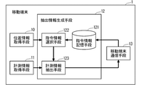
- FIG. 1 It is a block diagram which shows the functional structure of the map generation system which concerns on Embodiment 1.
- FIG. It is a block diagram which shows the functional structure of the mobile terminal which concerns on Embodiment 1.
- FIG. It is a figure which shows an example of the operation of the command information selection means of the mobile terminal which concerns on Embodiment 1.
- FIG. It is a figure which shows an example of the operation of the measurement information extraction means of the mobile terminal which concerns on Embodiment 1.
- FIG. It is a figure which shows an example of the operation of the measurement information extraction means of the mobile terminal which concerns on Embodiment 1.
- FIG. It is a figure which shows an example of the operation of the measurement information extraction means of the mobile terminal which concerns on Embodiment 1.
- FIG. It is a figure which shows an example of the operation of the measurement information extraction means of the mobile terminal which concerns on Embodiment 1.
- FIG. It is a figure which shows an example of the operation of the measurement information extraction means of the mobile terminal which concerns on Em
- FIG. It is a figure which shows an example of the operation of the measurement information extraction means of the mobile terminal which concerns on Embodiment 1.
- FIG. It is a block diagram which shows the functional structure of the central apparatus which concerns on Embodiment 1.
- FIG. It is a figure which shows an example of the operation of the central apparatus which concerns on Embodiment 1.
- FIG. It is a figure which shows an example of the operation of the central apparatus which concerns on Embodiment 1.
- FIG. It is a figure which shows an example of the operation of the central apparatus which concerns on Embodiment 1.
- FIG. It is a figure which shows an example of the operation of the central apparatus which concerns on Embodiment 1.
- FIG. It is a flowchart which shows an example of the operation of the mobile terminal which concerns on Embodiment 1.
- FIG. It is a flowchart which shows an example of the operation of the central apparatus which concerns on Embodiment 1.
- FIG. It is a block diagram which shows the functional structure of the map generation system which concerns on Embodiment 2. It is a figure which shows an example of the operation of the mobile terminal which concerns on Embodiment 2.
- FIG. It is a figure which shows an example of the operation of the mobile terminal which concerns on Embodiment 2.
- FIG. It is a figure which shows an example of the operation of the mobile terminal which concerns on Embodiment 2.
- FIG. It is a figure which shows an example of the operation of the central apparatus which concerns on Embodiment 2.
- FIG. It is a block diagram which shows the functional structure of the map generation system which concerns on Embodiment 3.
- FIG. It is a figure which shows an example of the operation of the central apparatus which concerns on Embodiment 3.
- FIG. It is a figure which shows an example of the operation of the central apparatus which concerns on Embodiment 3.
- FIG. It is a figure which shows an example of the operation of the central apparatus which concerns on Embodiment 3.
- FIG. It is a block diagram which shows the functional structure of the map generation system which concerns on Embodiment 4.
- FIG. It is a figure which shows an example of the operation of the central apparatus which concerns on Embodiment 4.
- FIG. It is a block diagram which shows the hardware composition of the central apparatus which concerns on other modification. It is a block diagram which shows the hardware composition of the central apparatus which concerns on other modification.
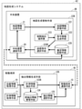
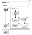
- FIG. 1 is a block diagram showing a functional configuration of the map generation system A1 according to the first embodiment.
- the map generation system A1 includes one or more mobile terminals 1 that can move together with the mobile bodies V1 to V3, and a central device 2 that communicates with the mobile terminals 1.
- the map generation system A1 measures the space around the moving objects V1 to V3 as the space for generating map information, that is, the space for plotting (hereinafter, may be referred to as "target space"), and the measurement result is obtained. Map information is generated by performing plotting processing based on.
- the mobile terminal 1 can move together with the mobile bodies V1 to V3, and is mounted on the mobile bodies V1 to V3, for example.
- the number of mobile bodies on which the mobile terminal 1 is mounted and the number of mobile terminals 1 are not limited to three.
- the central device 2 is installed on the ground, and the mobile terminal 1 generates map information based on the extracted information extracted from the measurement result.
- the map information is information that records the position, the shape, or both of the features existing in the target space with the position accuracy of the submeter class or higher.
- the map information is, for example, road map information that records features on the road, indoor map information that records indoor features, and the like.
- the map information may include the attributes and connection relationships of the features in addition to the position and shape of the features.
- the feature includes a physical feature that actually exists in the target space and a virtual feature that virtually exists in the target space.
- the feature is a road shoulder edge, a lane marking, a stop line, a traffic light, a sign, a road mark, a street light, a road center line, a lane center line, and the like.
- the features are, for example, columns, doors, lights, air conditioners, elevators, evacuation guide lights, virtual lanes, virtual walls, etc. in the case of indoor map information.
- the mobile bodies V1 to V3 are animals or machines having means for moving in the target space.
- the moving body is, for example, a person, a vehicle, a mobile robot, a drone, or the like.
- the mobile terminal 1 may move in the target space along with the moving body, and may be mounted on the moving body or possessed, for example. Hereinafter, the mobile terminal 1 will be described as being mounted on the mobile body.
- the mobile terminal 1 and the central device 2 temporarily store, for example, a storage device for storing programs and parameters, a CPU (Central Processing Unit) for executing the program, a result calculated by the CPU, and a program executed by the CPU. It is a computer composed of a memory to be held and an interface for communicating with other devices.
- a storage device for storing programs and parameters
- a CPU Central Processing Unit
- It is a computer composed of a memory to be held and an interface for communicating with other devices.
- the central device 2 may be, for example, a cloud server installed on the Internet, a MEC (Multi access Edge Computing) server installed on a core network such as a mobile phone network, or a business. It may be an offline server installed by a person.
- MEC Multi access Edge Computing
- the hardware configuration of the mobile terminal 1 and the central device 2 will be described in detail in a modified example.
- FIG. 2 is a block diagram showing a functional configuration of the mobile terminal 1 according to the first embodiment.
- the mobile terminal 1 acquires (i) position information of the moving body and measurement information around the moving body based on the measurement results of the sensor mounted on the moving body, and (ii) moves from the position information and the central device 2. Based on the command information transmitted to the terminal 1, the extraction result extracted from the measurement information is generated as extraction information, (iii) the position information and the extraction information are transmitted to the central device 2, and the command information is transmitted from the central device 2. It is an information processing device that receives.
- the extracted information substantially includes the position information
- both the position information and the extracted information will be transmitted.
- Location information and extraction information may be transmitted separately.
- the extraction information when the extraction information is transmitted, it may be described that the location information and the extraction information are transmitted.
- the extracted information includes the position information, but the extracted information may not include the position information.
- the mobile terminal 1 acquires position information acquisition means 10 for acquiring the position of the moving body, measurement information acquisition means 11 for measuring the target space around the moving body and acquiring measurement information, and extraction information extracted from the measurement information.
- the extraction information generation means 12 to be generated and the mobile terminal communication means 13 for communicating information with the central device 2 are provided.
- the position information acquisition means 10 acquires the position information of the moving body based on the measurement result of the positioning sensor mounted on the moving body.
- the measurement information acquisition means 11 measures the space around the moving body as the space to be plotted and acquires the measurement information based on the measurement result of the space measurement sensor mounted on the moving body.
- the extraction information generation means 12 generates partial measurement information extracted from the measurement information as extraction information based on the position information and the command information transmitted from the central device 2 to the mobile terminal 1.
- the mobile terminal communication means 13 communicates information with the central device 2.
- the command information is generated by the central device 2 and used for the extraction information generation means 12 of the mobile terminal 1.
- the command information is a target place that represents a place to be extracted from the measurement information by the extraction process for the extraction information and a target place that is a feature type that represents the feature to be extracted from the measurement information by the extraction process for the extraction information. Includes product type.
- the target place is information representing a point or area in the target space as a place to apply the extraction process using the command information.
- the expression format of the target location may be, for example, an expression format using the center coordinates and the distance from the center coordinates, an expression format using the coordinate point sequence and the distance from the coordinate point sequence, or the coordinate point sequence. It may be an expression format using the area of.
- the feature type is information that uniquely represents one or more types of features in the mobile terminal 1 and the central device 2, and the target feature type is a feature type to which the extraction process using the command information is applied.
- Information to represent may be a name or an identifier assigned to each feature of the map information, or may be a name or an identifier that is a collection of a plurality of features of the map information.
- the feature type of the road map information may include "road shoulder edge”, “section line”, “stop line”, “road center line”, “lane center line”, etc. assigned to each type of feature.
- it may include a "white line” that is a collection of a plurality of features such as a "partition line” and a "stop line”.
- the command information may include information other than the target location and the target feature type.
- the command information is, for example, an identifier for uniquely identifying the command information, a generation time indicating the time when the command information is generated, a valid period indicating the period during which the command information is valid, and an application condition indicating the conditions for applying the command information. Etc. may be included.
- the position information acquisition means 10 is a processing unit that estimates the current position of a mobile body on which the mobile terminal 1 is mounted and acquires the estimation result as position information.
- the position information acquisition means 10 estimates the current position of the moving body by using, for example, a positioning sensor that estimates the position.
- the positioning sensor of the position information acquisition means 10 may be one that can directly acquire the position information or one that can estimate the position information from the output value of the positioning sensor.
- the positioning sensor for example, GNSS (Global Navigation Satellite System) may be used, a radio wave beacon may be used, an IMU (Inertial Measurement Unit) may be used, or a combination thereof may be used. ..
- the position information is information that uniquely represents the coordinates where the moving body exists and the moving direction of the moving body as the position of the moving body.
- the position information may be expressed in the form of latitude, longitude, or azimuth, for example, or may be expressed in the form of X coordinate, Y coordinate, or angle of rotation.
- the position information acquisition means 10 provides the position information to the extraction information generation means 12.
- the extraction information generation means 12 for which the position information is provided from the position information acquisition means 10 provides the position information to the mobile terminal communication means 13.
- the location information acquisition means 10 may directly provide the location information to the mobile terminal communication means 13. In the following description, for convenience of explanation, the position represented by the position information and the position information may not be distinguished.
- the measurement information acquisition means 11 is a processing unit that measures the target space around the mobile body on which the mobile terminal 1 is mounted and acquires the measurement result as measurement information.
- the measurement information acquisition means 11 measures the target space around the moving body by using, for example, a space measurement sensor that measures the space.
- the spatial measurement sensor of the measurement information acquisition means 11 may be one that can directly measure the relative distance between the spatial measurement sensor and the feature around the moving body, or one that can estimate the relative distance from the output value of the spatial measurement sensor. ..
- the space measurement sensor for example, an LRF (Laser Range Finder) may be used, a stereo camera may be used, a ToF (Time Of Flat) camera may be used, or a combination thereof may be used. good.
- the measurement information is information including a set of distance points representing the relative distance between the space measurement sensor and the feature.
- the measurement information may include a set of color pixels.
- the measurement information may be expressed in a set format of, for example, a distance, an azimuth angle, and an elevation / depression angle, may be expressed in a set format of X coordinate, Y coordinate, and Z coordinate, and may be expressed in a set format of distance, X coordinate, and Y coordinate. It may be expressed in the set form of.
- the measurement information acquisition means 11 provides the measurement information to the extraction information generation means 12.
- the extraction information generation means 12 estimates from (i) the measurement information in association with the feature type representing the feature type and the feature area representing the feature area, and (ii) the position information and the feature. Processing to generate extraction information extracted from measurement information for the feature area corresponding to the feature type based on the judgment result of whether the type corresponds to the target location of the command information and the target feature type respectively. It is a department.
- the extraction information generation means 12 (i) generates command information used for generating extraction information based on a determination result of whether or not the position information corresponds to the target location of the command information from the central device 2. It is selected, (ii) the feature type and the feature area are estimated in association with each other from the measurement information, and (iii) the feature type obtained by the estimation corresponds to the target feature type of the command information obtained by the selection. Based on the determination result of whether or not, partial measurement information extracted from the measurement information for the feature area corresponding to the feature type is generated as the extraction information.
- the extraction information generation means 12 transmits the extraction information to the central device 2 by using the mobile terminal communication means 13. At this time, the extraction information generation means 12 may sequentially transmit the extraction information to the central device 2, or may collectively store a plurality of extraction information in the central device by using a means for temporarily storing the extraction information. You may send to 2.
- the extraction information generation means 12 may sequentially process the measurement information acquired by the measurement information acquisition means 11, or may synthesize time-series data of the measurement information and process them collectively.
- synthesis may be performed by superimposing each measurement information on the basis of position information, or synthesis is performed by performing alignment processing between measurement information. You may.
- the extraction information generation means 12 stores partial measurement information based on the command information storage means 121 for storing the command information, the command information selection means 122 for selecting the command information, and the command information selected by the command information selection means 122. It is provided with measurement information extraction means 123 that is generated as extraction information.
- the command information storage means 121 stores command information transmitted from the central device 2 to the mobile terminal 1, that is, command information received by the mobile terminal communication means 13, and selects command information in response to a request from the command information selection means 122.
- the command information selection means 122 determines (i) whether or not the position information acquired by the position information acquisition means 10 corresponds to the target location of the command information stored in the command information storage means 121, and (ii). ) A processing unit that selects command information determined to be applicable from the command information storage means 121 as command information used in the measurement information extraction means 123.
- the command information selection means 122 provides the selected command information or a list thereof to the measurement information extraction means 123.
- the command information selection means 122 also provides the position information to the measurement information extraction means 123, but when the measurement information to be described later is not synthesized, the position information is provided to the measurement information extraction means 123. It does not have to be.
- the command information selection means 122 determines whether or not the coordinates included in the position information are included in the point or area representing the target place.
- the command information selection means 122 determines that the position information is included in the target location, it determines that the location information corresponds to the target location of the command information, and when it determines that the location information is not included, the location information is commanded. Judge that it does not correspond to the target location of the information.
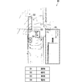
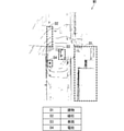
- FIG. 3 is a diagram showing an example of an operation related to the command information selection means 122.
- FIG. 3A represents command information C1 to C3 stored by the command information storage means 121.
- Each of the command information C1 to C3 includes a target location designated by the shape type and the shape details, and a target feature type.
- FIG. 3B illustrates the mobile body V1 on which the mobile terminal 1 is mounted, the target space E in which the mobile body V1 moves in the space around the mobile body V1, and the target locations of the command information C1 to C3. It is a figure.
- the broken lines of the command information C1 to C3 represent the target location.
- the command information selection means 122 determines whether or not the position information of the moving body V1 corresponds to the target location of the command information C1.
- the command information selection means 122 compares the position information of the moving body V1 with the target place of the command information C1, and when the moving body V1 exists in the target place of the command information C1 as shown in FIG. 3 (b). , It is determined that the position information of the moving body V1 corresponds to the target place of the command information C1.
- the command information selection means 122 selects the command information C1 as the command information used by the measurement information extraction means 123.
- the command information selection means 122 determines whether or not the position information of the moving body V1 corresponds to the target location of the command information C2, similarly to the command information C1.
- the command information selection means 122 determines that the position information of the moving body V1 does not correspond to the target place of the command information C1 when the moving body V1 exists outside the target place of the command information C2 as shown in FIG. 3 (b). do.
- the command information selection means 122 determines whether or not the position information of the moving body V1 corresponds to the target location of the command information C2, similarly to the command information C1 and C2. The command information selection means 122 determines that the position information of the moving body V1 does not correspond to the target place of the command information C3 when the moving body V1 exists outside the target place of the command information C3 as shown in FIG. 3 (b). do.
- the command information selection means 122 provides the selected command information C1 to the measurement information extraction means 123.
- the measurement information extraction means 123 synthesizes (i) one or more measurement information based on the position information, the measurement information, and the command information selected by the command information selection means 122, and (ii) grounds from the measurement information. Estimate by associating the property type with the feature area, and (iii) the feature corresponding to the feature type based on the determination result of whether or not the feature type corresponds to the target feature type of the command information. It is a processing unit that generates the extraction information extracted from the measurement information for the area.
- the measurement information extraction means 123 will be specifically described.
- the measurement information extraction means 123 rotates or translates a plurality of measurement information based on the plurality of position information acquired by the position information acquisition means 10 and the plurality of measurement information acquired by the measurement information acquisition means 11. Adjusts the reference position of multiple measurement information by, and synthesizes multiple measurement information.
- the measurement information extraction means 123 uses one measurement information, the synthesis process may be skipped, and as a result, the position information may not be used.
- the measurement information extraction means 123 applies the feature estimation process to the measurement information synthesized by the synthesis process, thereby representing the type of the feature reflected in the measurement information and the feature. Estimate in association with the feature area that represents the area where the information exists.
- the measurement information extraction means 123 selects the feature type when it is determined that the feature type obtained by the above estimation corresponds to the target feature type of the command information selected by the command information selection means 122. do.
- the measurement information extraction means 123 extracts a subset of the measurement information corresponding to the feature area corresponding to the selected feature type, and generates the extraction result as the extraction information.
- the feature area corresponding to the selected feature type is the feature area estimated together with the selected feature type.
- the measurement information extraction means 123 extracts a subset of the measurement information corresponding to the periphery of the feature area in addition to the subset of the measurement information corresponding to the feature area, and generates the extraction result as the extraction information. May be good.
- the measurement information extraction means 123 provides the generated extraction information to the mobile terminal communication means 13.
- the feature area is a range (area) on the target space or a range (area) within the measurement information, where the feature is estimated to exist by the feature detection process.
- the feature area may be represented by a rectangular parallelepiped surrounding the feature, a polyhedron matching the shape of the feature, or a plane, as long as the range in which the feature exists can be represented. It may be represented by a rectangle surrounding the feature in the bird's-eye view.
- the feature estimation process of the measurement information extraction means 123 may be any estimation process that estimates the feature type and the feature area from the measurement information.
- the feature estimation process may be a geometric estimation method that estimates a feature associated with the threshold value in advance based on a threshold value such as a position, a shape, and a size preset for each feature type.
- the feature estimation process may be a model estimation method for estimating features by a RANSAC (Random Samples Consensus) method or the like based on a model preset for each feature type.
- the feature estimation process may be an estimation method by machine learning that detects a feature type and a feature area feature using a convolutional neural network that estimates a feature type and a feature area.
- the number of command information selected by the command information selection means 122 may be 0 or a plurality.
- the measurement information extraction means 123 may perform extraction according to a preset default feature type, may stop extraction, or extract for all feature types. You may.
- the measurement information extraction means 123 may integrate the plurality of extraction information into one extraction information, or may handle the plurality of extraction information as they are.
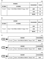
- FIGS. 4 to 7 are diagrams showing an example of the operation of the measurement information extraction means 123.
- the target feature type of the command information is "telephone pole".
- the measurement information extraction means 123 acquires the measurement information M1 as shown in FIG. 4 from the measurement information acquisition means 11.
- FIG. 4 is a bird's-eye view of the measurement information M1 represented by a point cloud of relative distances centered on a moving body.
- FIG. 5 is a diagram showing how four features D1 to D4 are estimated (detected) from the measurement information M1.
- FIG. 5 shows the results of estimation (detection) of the feature type and the feature area by the feature detection process, and the feature types of the features D1 to D4 are "building", “curb", and “curbstone”, respectively. It is a "vehicle” and a "telephone pole", and the feature area of the features D1 to D4 is represented by a broken line frame.
- the measurement information extraction means 123 determines whether or not the feature types of the features D1 to D4 correspond to the target feature type "telephone pole" of the command information, and in the example of FIG. 5, the feature D4 It is determined that the feature type corresponds to the target feature type.
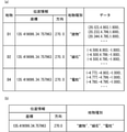
- the measurement information extraction means 123 generates the extraction information M2 as shown in FIGS. 6 and 7 by extracting the feature area of the feature D4 from the measurement information M1. Note that FIG. 6 is a bird's-eye view of the extraction information M2. FIG. 7 is a diagram showing the extraction information M2.
- the extracted information includes the position information used as the reference position of the measurement information, the data representing the subset of the distance data extracted from the measurement information for the feature area, and the data. It corresponds to the target feature type and includes the feature type of the feature represented by the data.
- the mobile terminal communication means 13 is a communication unit that performs information communication with the central device 2.
- the mobile terminal communication means 13 transmits the extraction information provided by the extraction information generation means 12 to the central device 2, or receives command information from the central device 2 and provides the extraction information generation means 12.
- the extracted information since the extracted information includes the position information and the feature type, the position information and the feature type are also transmitted to the central device 2 by transmitting the extracted information to the central device 2.
- the communication method of the mobile terminal communication means 13 may be as long as the moving mobile terminal 1 can communicate with the central device 2.
- wide area radio communication such as LTE (Long Term Evolution), WiMAX (World Interactivity For Microwave Access) may be used, 5G (5 Generation), wireless LAN (Local Area Network), wireless LAN (Local Area Network), Narrow-range radio wave communication such as DSRC (Dedicated Short Range Communication) may be used, or a mobile communication method using light or sound other than radio waves may be used.
- the mobile terminal 1 and the central device 2 do not need to directly communicate information, and may communicate information via a wired communication or wireless communication network.
- FIG. 8 is a block diagram showing a functional configuration of the central device 2 according to the first embodiment.
- the central device 2 (i) generates map information based on the extracted information provided by the mobile terminal 1, (ii) evaluates the completeness of the map information, and (iii) generates command information based on the completeness. (Iv) An information processing device that selects command information and transmits it to the mobile terminal 1.
- the central device 2 includes a central device communication means 20 that performs information communication with the mobile terminal 1, a map information generation means 21 that generates map information based on extracted information, and a map generation control means 22 that generates command information based on map information. To prepare for.
- the central device communication means 20 is a communication unit that performs information communication with the mobile terminal 1.
- the central device communication means 20 receives the extracted information from the mobile terminal 1 and provides the extracted information (position information and feature type) to the map information generation means 21 and the map generation control means 22, or the map generation control means.
- the command information generated by the means 22 is transmitted to the mobile terminal 1.
- the communication method of the central device communication means 20 may be the same as that of the mobile terminal communication means 13 as long as the moving mobile terminal 1 and the central device 2 can communicate with each other.
- the map information generation means 21 (i) selects a feature estimation method according to the feature type of the extracted information based on the extracted information provided by one or more mobile terminals 1, and (ii) estimates the feature. It is a processing unit that generates map information for each feature type using the method.
- the map information generation means 21 uses the estimation method selection means 211 to select the feature estimation method from a plurality of feature selection methods and the feature estimation method selected by the estimation method selection means 211 to obtain the position of the feature or the feature. It is provided with a feature estimation means 212 for estimating the shape. A plurality of feature estimation methods are prepared for each feature type in the feature estimation means 212, and feature estimation methods A to C are prepared in FIG. 8.
- the estimation method selection means 211 uses a feature estimation method corresponding to the feature type of the extracted information transmitted from the mobile terminal 1 to the central device 2 among the plurality of feature estimation methods for the feature estimation means 212. It is a processing unit selected as a feature estimation means.
- the correspondence between the feature type and the plurality of feature estimation methods is set in advance, and the estimation method selection means 211 searches the correspondence relationship for the same feature type as the feature type of the extracted information. Then, the estimation method selection means 211 selects, among the plurality of feature estimation methods, the feature estimation method corresponding to the feature type as the feature estimation means used in the feature estimation means 212.
- the feature estimation means 212 estimates the position or shape of the feature using the feature estimation method selected by the estimation method selection means 211, and (ii) applies statistical processing as appropriate to the feature. It is a processing unit that improves the accuracy of the position and shape of (iii) and generates map information for each feature type based on the position or shape of the feature.
- the feature estimation means 212 uses the feature estimation method to correct the reference position represented by the position information of the extracted information when there is map information being created.
- the feature estimation means 212 estimates the position and shape of the feature by performing feature estimation processing such as a geometric calculation method, a model estimation method, and machine learning on the extracted information.
- the feature estimation means 212 estimates the same feature by matching the feature estimated this time with the feature estimated so far by the feature type of the extraction information and the position and shape. The accuracy of the position and shape of the feature is improved by appropriately applying statistical processing to the feature.
- the feature estimation means 212 generates or updates the map information for each feature type by recording the estimation result for the map information for each feature type. At this time, if map information of a plurality of different feature types already exists, the feature estimation means 212 may integrate these.
- the map generation control means 22 includes (i) evaluates the degree of perfection of the map information generated by the map information generation means 21, and (ii) switches the target feature type based on the degree of perfection, and includes the target feature type. It is a processing unit that generates and selects command information.
- the map generation control means 22 switches the target feature types in a predetermined order of the degree of completion based on the degree of completion of the map information. For example, in the case of a map generation system related to road map information, the map generation control means 22 switches the target feature type in the order of “road”, “white line”, and “structure”.
- the map generation control means 22 includes a map information evaluation means 221, a command information generation means 222, a feature extraction order table 223, a command information management means 224, and a transmission command selection means 225.
- the map information evaluation means 221 evaluates the degree of perfection of the map information generated by the map information generation means 21.
- the map information evaluation means 221 may evaluate the degree of perfection of the map information generated by the map information generation means 21 for the entire target feature type or for each target feature type.
- the feature extraction order table 223 shows the correspondence between the degree of perfection and the target feature type. Based on the degree of perfection evaluated by the map information evaluation means 221, the command information generating means 222 switches the target feature type corresponding to the perfection according to the feature extraction sequence table 223, and the command information including the target feature type. To generate.
- the command information management means 224 manages the command information by registering, storing, and deleting the command information generated by the command information generation means 222.
- the transmission command selection means 225 predicts the reach range representing the reach range of the mobile terminal 1 based on the position information of the extracted information transmitted from the mobile terminal 1 to the central device 2. Then, the transmission command selection means 225 selects the command information transmitted from the central device 2 to the mobile terminal 1 from the command information management means 224 based on the reachable range and the target location of the command information.
- the map information evaluation means 221 (i) evaluates the position accuracy of the feature included in the map information based on the map information generated by the map information generation means 21, and (ii) completes the map information based on the evaluation result. It is a processing unit that calculates the degree.
- the map information evaluation means 221 determines the evaluation range, which is the range of the evaluation target, from the range represented by the map information.
- the evaluation range is a range included in the range represented by the map information.
- one or more evaluation ranges can be determined from the map information by dividing the map information into one or more ranges (areas).
- the map information evaluation means 221 may determine one or more cells divided by a preset grid as an evaluation range. Further, for example, the map information evaluation means 221 may determine the range updated by the map information generation means 21 as the evaluation range. Further, for example, the map information evaluation means 221 acquires a division point between features (for example, a road-to-road junction) based on the map information being generated, is divided by the division point, and the feature exists. The range may be determined as the evaluation range.
- the map information evaluation means 221 evaluates the certainty indicating how likely the position accuracy of the feature within the evaluation range is, and calculates the degree of perfection of the map information based on the evaluation result of the certainty.
- the position accuracy of the map information evaluation means 221 should be evaluated so that the higher the position accuracy, the higher the degree of perfection.
- the map information evaluation means 221 may evaluate the map information evaluation means 221 so that the higher the number of measurements, the higher the degree of perfection, based on the number of times the features of the feature type are measured within the evaluation range. Further, for example, the map information evaluation means 221 may evaluate based on the time measured within the evaluation range so that the longer the measurement time, the higher the degree of perfection. Further, for example, the map information evaluation means 221 may be evaluated based on the statistical processing result of the map information generation means 21 so that the degree of perfection increases as the fluctuation error of the position of the feature becomes smaller.
- the degree of perfection is an index showing how much the map information is completed in whole or in part.
- the degree of perfection may be any information that can determine the stage of the map information generation process.
- the degree of perfection may be the feature type and its position accuracy as it is, or may be a value obtained by quantifying the feature type and its position accuracy.
- the numerical value of the feature type and its position accuracy may be a value obtained by quantifying the feature type and its position accuracy with a threshold value, or may be a value obtained by normalizing the feature type and its position accuracy. It may be a numerical value or an identifier expressing continuous values from the start to the end of map generation by converting the feature type and the position accuracy with a preset list.
- the command information generating means 222 searches for the target feature type corresponding to the perfection according to the feature extraction sequence table 223 based on the perfection evaluated by the map information evaluation means 221 and includes the target feature type to be extracted. It is a processing unit that generates command information.
- the command information generation means 222 generates command information including all or a part of the evaluation range determined by the map information evaluation means 221 as a target place. As described above, the command information generated by the command information generation means 222 includes all or a part of the evaluation range determined by the map information evaluation means 221 as the target location, and is completed from the feature extraction sequence table 223. Includes target feature types indexed by degree.
- the feature extraction order table 223 is an index table that describes the target feature types to be extracted by the mobile terminal 1 for each degree of completion. For example, in a map generation system for road map information, if the degree of completion is evaluated in three stages, the degree of completion "1" is "road” and the degree of completion "2" is in the feature extraction sequence table 223. "White line” and perfection level 3 are set as "structure”.
- one target feature type may be listed multiple times. For example, in the map generation system for road map information, if the degree of completion is evaluated in four stages, the first "road” is completed for the degree of completion "1" in the feature extraction sequence table 223. A “white line” may be set for the degree "2", a “structure” may be set for the degree of completion 3, and a second "road” may be set for the degree of completion 4.
- the command information management means 224 manages command information by registering, storing, and deleting one or more command information generated by the command information generation means 222, and sends command information in response to a request from the transmission command selection means 225. It is a database part to be provided.
- the command information management means 224 may also hold the degree of perfection calculated by the map information evaluation means 221. In that case, the command information generation means 222 may determine the command information with reference to the degree of perfection.
- the transmission command selection means 225 predicts the reach of the mobile terminal 1 based on (i) the position information of the extracted information transmitted from the mobile terminal 1 to the central device 2, and is stored by (ii) the command information management means 224.
- This is a processing unit that selects command information including a target location within the reachable range, and (iii) transmits the command information to the mobile terminal 1 using the central device communication means 20.
- the transmission command selection means 225 is a range located within a certain distance (for example, within 3 kilometers) with respect to the position represented by the position information, for example, based on the position information transmitted from the mobile terminal 1 as a range prediction process. May be predicted as the reach. Further, for example, the transmission command selection means 225 may predict the range within a certain period of time (for example, within 5 minutes) around the position represented by the position information as the reach range as the process of predicting the reach range. Further, for example, the transmission command selection means 225 may predict a route existing within a certain distance range from the position of the moving body represented by the position information as a reach range based on the information about the route and the position information. Further, the transmission command selection means 225 may predict the range set by the user of the central device 2 as the reachable range.
- FIGS. 9 to 12 are diagrams showing an example of the operation related to the central device 2.
- the central device 2 generates road map information.
- the central device 2 evaluates the degree of perfection in the order of three stages "1", “2", and “3”, and the target feature types are "road”, “white line”, and so on.
- the target feature types are "road", “white line”, and so on.
- it is a "structure”.
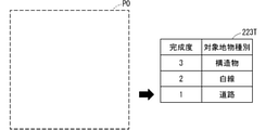
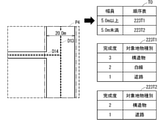
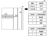
- FIG. 9 is a diagram showing the initial state of the central device 2.
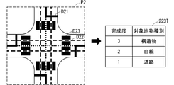
- the map information P0 generated by the map information generation means 21 and the feature extraction sequence table 223T of the map generation control means 22 are shown.
- the degree of completion "1" corresponds to the target feature type "road”
- the degree of completion "2" corresponds to the target feature type "white line”
- the degree of completion "3" Corresponds to the target feature type "structure”. Since the degree of completion is "1", which is the lowest in the initial state, the map generation control means 22 generates command information including the target feature type "road”.
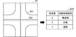
- FIG. 10 is a diagram showing the first state after the initial state of the central device 2.
- the map information generation means 21 generates map information P1 including the target feature type “road” based on the extracted information that the mobile terminal 1 receives and transmits the command information.
- the road shoulder line D11 and the road center line D12 correspond to the target feature type “road” included in the map information P1.
- the map generation control means 22 evaluates the map information P1 and determines that the map information of the target feature type "road” is completed, the degree of completion is changed from “1" to "2".
- the map generation control means 22 generates command information including the target feature type “white line” according to the feature extraction order table 223T.
- FIG. 11 is a diagram showing a second state after the first state of the central device 2.
- the map information generation means 21 generates map information P2 including the target feature type “road” and “white line” based on the extracted information that the mobile terminal 1 receives and transmits the command information.
- the target feature type “white line” included in the map information P2 corresponds to the lane marking line D21, the lane center line D22, and the pedestrian crossing D23.
- the map generation control means 22 evaluates the map information P2 and determines that the map information of the target feature type "white line” is completed, the degree of completion is changed from “2" to "3".
- the map generation control means 22 generates command information including the target feature type “structure” according to the feature extraction order table 223T.
- FIG. 12 is a diagram showing the third state after the second state of the central device 2.
- the map information generation means 21 generates map information P3 including the target feature types “road”, “white line”, and “structure” based on the extracted information that the mobile terminal 1 receives and transmits the command information. Generate.
- the traffic light D31, the utility pole D32, and the pole D33 correspond to the target feature type “structure” included in the map information P3.
- the map generation control means 22 evaluates the map information P3, and when it is determined that the map information of the target feature type "structure" is completed, it is determined that the map information is completed.
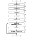
- FIG. 13 is a flowchart showing an example of the operation of the mobile terminal 1 of the map generation system A1.
- step S101 the mobile terminal communication means 13 of the mobile terminal 1 receives the command information transmitted from the central device 2. Further, in step S101, the mobile terminal communication means 13 provides the command information to the command information storage means 121. When step S101 is completed, the process proceeds to step S102.
- step S102 the position information acquisition means 10 acquires the position information of the moving body and provides the position information to the command information selection means 122.
- step S102 the process proceeds to step S103.
- step S103 the measurement information acquisition means 11 acquires measurement information around the moving body and provides the measurement information to the measurement information extraction means 123.
- step S103 the process proceeds to step S104.
- step S104 the command information selection means 122 selects (searches) command information from the command information storage means 121 based on the position information acquired in step S102.
- step S104 the process proceeds to step S105.
- step S105 the measurement information extraction means 123 performs the feature estimation process based on the measurement information acquired in step S103, and estimates the feature type and the feature area in association with each other.
- step S105 the process proceeds to S106.
- step S106 the measurement information extraction means 123 determines whether or not the feature type estimated in step S105 corresponds to the target feature type of the command information selected in step S104. If it is determined that the case does not apply, the series of processes shown in FIG. 13 is completed without transmitting the extraction information. If it is determined to be applicable, the process proceeds to step S107 so that the extraction information is transmitted.
- step S107 the measurement information extraction means 123 partially extracts the measurement information based on the feature area corresponding to the corresponding feature type in step S106, and generates the extraction result as the extraction information. Then, the measurement information extraction means 123 provides the generated extraction information to the mobile terminal communication means 13. When step S107 is completed, the process proceeds to step S108.
- step S108 the mobile terminal communication means 13 transmits the extracted information generated in step S107 to the central device 2.
- the extracted information since the extracted information includes the position information and the feature type, the position information and the feature type are transmitted to the central device 2 together with the extracted information.
- the mobile terminal 1 is configured so that the extraction information does not include the location information and the feature type, the extraction information, the location information, and the feature type may be separately transmitted to the central device 2. ..
- step S108 is completed, the series of processes shown in FIG. 13 is completed. Although not shown in FIG. 13, the process may return to step S101 after the step S108 is completed.
- steps S101 to S103 may be rearranged in order or executed in parallel. Further, the process of step S101 does not have to be executed in the initial state, and specifically, it may be executed only when a series of flows is completed and the central device 2 transmits command information.
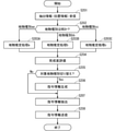
- FIG. 14 is a flowchart showing an example of the operation of the central device 2 of the map generation system A1.
- step S201 the central device communication means 20 of the central device 2 receives the extracted information transmitted from the mobile terminal 1. Further, in step S201, the central device communication means 20 provides the extracted information to the map information generation means 21 and the map generation control means 22.
- the extracted information since the extracted information includes the position information and the feature type, the position information and the feature type are received and provided by the central device communication means 20 together with the extracted information.
- the mobile terminal 1 is configured so that the extraction information does not include the location information and the feature type, the extraction information, the location information, and the feature type are separately received and provided by the central device communication means 20. May be done.
- step S201 is completed, the process proceeds to step S202.
- step S202 the estimation method selection means 211 of the map information generation means 21 selects the feature estimation method to be executed in the next step based on the feature type of the extracted information acquired in step S201.
- the feature estimation processes a to c performed by the three feature estimation methods A to C in FIG. 5 are shown. If the feature type of the extracted information is the feature type aa, the process proceeds to step S203A, and if the feature type of the extracted information is the feature type bb, the process proceeds to step S203B, and the feature type of the extracted information is selected. If is a feature type cc, the process proceeds to step S203C.
- step S203A to S203C the feature estimation means 212 of the map information generation means 21 generates map information by implementing the feature estimation methods A to C based on the extracted information including the position information acquired in step S201. , The map information is provided to the map generation control means 22.
- step S204 the process proceeds to step S204.
- step S204 the map information evaluation means 221 of the map generation control means 22 calculates the degree of perfection by evaluating the map information generated in steps S203A to S203C, and the degree of completion is the command information of the map generation control means 22. Provided to the generation means 222. When step S204 is completed, the process proceeds to step S205.
- step S205 the command information generation means 222 of the map generation control means 22 is extracted by the target feature type, that is, the mobile terminal 1 according to the feature extraction sequence table 223 based on the degree of perfection obtained by the calculation in step S204. Determine whether to switch the type of feature to be.
- the process proceeds to step S206, and when the target feature type is not switched, the process proceeds to step S207.
- step S206 the command information generation means 222 of the map generation control means 22 determines the target location and the target feature type based on the map information generated in steps S203A to S203C and the target feature type determined in step S205.
- the command information including the command information is generated, and the command information is stored in the command information management means 224.
- step S207 the transmission command selection means 225 of the map generation control means 22 predicts the reach range based on the position information included in the extraction information acquired in step S201. Then, the transmission command selection means 225 selects (extracts) command information including the target location within the reach from the command information stored in step S206, and provides the command information to the central device communication means 20.
- step S207 the process proceeds to step S208.
- step S208 the central device communication means 20 transmits the command information selected in step S207 to the mobile terminal 1.
- step S208 the series of processes shown in FIG. 14 is completed. Although not shown in FIG. 14, the process may return to step S201 after step S208 is completed.
- steps S201 and S202 may be rearranged in order or executed in parallel. Further, when only the position information is obtained in step S201, only the processes of steps S207 and S208 may be executed.
- the map generation control means 22 evaluates the degree of perfection of the map information to generate command information including the target feature type corresponding to the degree of perfection.
- the extraction information generation means 12 generates extraction information based on a determination result of whether or not the feature type estimated from the measurement information corresponds to the target feature type of the command information.
- the map generation system A1 is required for the information transmitted from the mobile terminal 1 to the central device 2 to be the information regarding the target feature type, that is, the central device 2 to generate the map information without the existing map information. Since it can be reduced to information, the amount of communication data can be appropriately reduced.
- the map generation control means 22 sequentially designates the target feature type of the command information based on the feature extraction order table 223 set in advance. As a result, the map generation system A1 can preferentially generate map information including a target feature type with high importance.
- the map generation control means 22 predicts the reach range based on the position information transmitted from the mobile terminal 1 to the central device 2, and the mobile terminal from the central device 2 based on the reach range and the target location of the command information. Determine the command information to be transmitted to 1.
- the map generation system A1 can increase the certainty of providing the command information to the mobile terminal 1 while reducing the number of times the command information is transmitted.
- the map information generation means 21 selects a feature estimation method based on the feature type included in the extracted information. As a result, the map generation system A1 does not need to perform estimation processing for all the feature types assumed by the central device 2, so that the processing load of the central device 2 can be reduced.
- FIG. 15 is a block diagram showing a functional configuration of the map generation system A2 according to the second embodiment. Since the basic configuration of the map generation system A2 according to the second embodiment is the same as the configuration of the map generation system A1 according to the first embodiment, the differences will be mainly described below.
- the central device In the map generation system A1 according to the first embodiment, the central device generates command information in advance, and the mobile terminal sequentially performs positioning and measurement to generate extraction information.
- the mobile terminal performs positioning and measurement in advance to generate temporary extraction information as a candidate for extraction information.
- the central device generates and sends command information at any time.
- the mobile terminal selects the extraction information to be transmitted from the provisional extraction information to the central device based on the command information.
- the map generation system A2 includes one or more mobile terminals 1B and a central device 2B instead of the mobile terminal 1 and the central device 2 of the map generation system A1 of the first embodiment.
- the mobile terminal 1B generates (i) temporary extraction information and estimation information from position information and measurement information, (ii) stores the temporary extraction information, and (iii) stores it based on the command information transmitted from the central device 2B.
- the extraction information to be transmitted to the central device 2B is selected from the provisional extraction information.
- the central device 2B generates map information based on (i) the extracted information provided by the mobile terminal 1B, (ii) evaluates the completeness of the map information, and (iii) generates command information based on the completeness. (Iv) Based on the command information and the estimated information transmitted from the mobile terminal 1B, the command information is selected and transmitted to the transmission source mobile terminal 1B.
- map information based on (i) the extracted information provided by the mobile terminal 1B, (ii) evaluates the completeness of the map information, and (iii) generates command information based on the completeness.
- the command information is selected and transmitted to the transmission source mobile terminal 1B.
- the mobile terminal 1B includes the extraction information generation means 12B instead of the extraction information generation means 12 of the first embodiment.
- the extraction information generation means 12B is a processing unit similar to the extraction information generation means 12 of the first embodiment.
- the extraction information generation means 12B estimates from (i) the measurement information acquired by the measurement information acquisition means 11 in association with the feature type and the feature area, and (ii) the measurement information and the ground. Temporary extraction information is generated based on the physical type and the feature area, and the temporary extraction information is stored. (Iii) Estimated information including the position information acquired by the position information acquisition means 10 and a list of feature types. It is a processing unit that generates and transmits to the central device 2B, and (iv) selects extraction information from the stored temporary extraction information based on the command information transmitted from the central device 2B to the mobile terminal 1B.
- the extraction information generation means 12B includes a measurement information extraction means and 123B, a temporary extraction information management means 124, and an extraction information selection means 125. Hereinafter, each component of the extraction information generation means 12B will be specifically described.
- the measurement information extraction means and 123B estimate (i) the feature type and the feature area in association with each other from the measurement information, and (ii) partially extract the feature area from the measurement information for each feature type.
- Control to generate measurement information as temporary extraction information generate estimation information including (iii) position information and a list of feature types of temporary extraction information, and transmit the estimated information from the mobile terminal 1B to the central device 2B. It is a processing unit to perform.
- the provisional extraction information of the second embodiment is similar to the extraction information (FIG. 7) according to the first embodiment. Specifically, the temporary extraction information is used for extracting the temporary extraction information, the position information used as the reference position of the measurement information, the data representing the subset of the distance data extracted from the measurement information for the feature area, and the temporary extraction information. , The feature type of the feature represented by the data.
- the measurement information extraction means 123B synthesizes a plurality of measurement information acquired by the measurement information acquisition means 11.
- the synthesis method may be the same as that of the measurement information extraction means 123 of the first embodiment.
- this synthesis process may be skipped.
- the measurement information extraction means 123B applies the feature estimation process to the measurement information synthesized by the synthesis process, and estimates the feature type and the feature area from the measurement information in association with each other.
- the feature estimation processing method may be the same as the feature estimation processing method of the measurement information extraction means 123 of the first embodiment.
- the measurement information extraction means 123B temporarily extracts each feature type by extracting the feature area corresponding to the feature type from the measurement information for each of all the feature types obtained by the above estimation. Generate information. Then, the measurement information extraction means 123B stores the provisional extraction information in the provisional extraction information management means 124.
- the measurement information extraction means 123B generates estimation information including position information and a list of feature types of provisional extraction information, and transmits the estimation information to the central device 2B using the mobile terminal communication means 13. ..
- the estimation information of the second embodiment is information including position information representing a reference position of measurement information and a list of feature types estimated by the feature estimation process, and includes distance data and the like like extracted information. Information that is not included.
- the estimation information may include, for example, a generation time representing the time when the estimation information was generated, or includes an identifier that uniquely identifies the moving object that generated the estimation information. But it may be.
- the temporary extraction information management means 124 is a database unit that manages temporary extraction information by registering, storing, and deleting the temporary extraction information.
- the temporary extraction information managed by the temporary extraction information management means 124 is registered by the measurement information extraction means 123B and referred to by the extraction information selection means 125.
- the temporary extraction information management means 124 since the temporary extraction information includes the position information and the feature type, the temporary extraction information management means 124 also stores the position information and the feature type by storing the temporary extraction information.
- the position information and the feature type of the temporary extraction information stored in the temporary extraction information management means 124 are the target location and the target feature type of the command information transmitted from the central device 2B to the mobile terminal 1B. It is determined whether or not each of the above is applicable.
- the extraction information selection means 125 selects the extraction information to be transmitted to the central device 2B from the temporary extraction information stored in the temporary extraction information management means 124 based on the determination result, and uses the mobile terminal communication means 13 to select the extraction information.
- the extracted information is transmitted to the central device 2B.
- the position information of the provisional extraction information corresponds to the target location of the command information
- the feature type of the provisional extraction information corresponds to the target feature type of the command information.
- the provisional extraction information is selected as the extraction information to be transmitted to the central device 2B.
- the determination of the target location and the determination of the target feature type may be the same as the determination of the command information selection means 122 and the determination of the measurement information extraction means 123 of the first embodiment, respectively.
- FIGS. 16 to 18 are diagrams showing an example of the operation related to the measurement information extraction means 123B.
- the examples of FIGS. 16 and 17 are the same as the examples of FIGS. 4 and 5 of the first embodiment.
- the measurement information extraction means 123B acquires the measurement information M1 as shown in FIG. 16 in the same manner as in FIG. Next, the measurement information extraction means 123B obtains the estimation result as shown in FIG. 17 by performing the feature estimation process on the measurement information M1 as in FIG. 5 of the first embodiment.
- FIG. 18A is a diagram showing the generated temporary extraction information.
- the provisional extraction information includes the position information, the feature type, and the data from which the measurement information is extracted.
- the measurement information extraction means 123B does not have to generate temporary extraction information regarding the feature D3 having the dynamic feature type “vehicle” which is not necessary for generating the map information. ..
- the measurement information extraction means 123B generates estimation information including position information and a list of feature types of provisional extraction information.
- FIG. 18B shows an example in which estimation information including location information and a list of feature types of provisional extraction information “building”, “curb”, and “telephone pole” is generated.
- the mobile terminal communication means 13 of the mobile terminal 1B is a communication unit that performs information communication with the central device 2B, and is generated not only by the communication of the mobile terminal communication means 13 of the first embodiment but also by the extraction information generation means 12B. Estimated information is transmitted to the central device 2B.
- the central device 2B includes the map generation control means 22B instead of the map generation control means 22 of the first embodiment.
- the map generation control means 22B (i) evaluates the degree of perfection of the map information, (ii) generates command information based on the degree of perfection, and (ii) stores the estimated information transmitted from the mobile terminal 1B to the central device 2B. Then, (iv), the command information is selected and transmitted to the transmission source mobile terminal 1B based on the command information and the stored estimation information.
- the command information management means 224 is deleted and the estimation information storage means 226 is added in the configuration of the map generation control means 22 of FIG. 8 of the first embodiment.
- the configuration is the same as the configuration in which the transmission command selection means 225 is changed to the transmission command selection means 225B.
- the estimated information storage means 226 is a database unit that manages the estimated information by registering, referencing, and deleting the estimated information transmitted from the mobile terminal 1B to the central device communication means 20.
- the estimation information storage means 226 manages the terminal identifier and the estimation information in association with each other.
- the terminal identifier may be any information as long as it is information that the central device 2B uniquely identifies the mobile terminal 1B, and the transmission command selection means 225B can identify the mobile terminal 1B that transmits the command information.
- the terminal identifier may be, for example, a unique number assigned to the mobile terminal 1B or a communication address of the mobile terminal 1B.
- a list of position information and feature types of estimated information stored by the estimation information storage means 226 is a target location and a target feature of the command information generated by the command information generation means 222. It is a processing unit that determines whether or not each type is applicable, and (ii) selects command information to be transmitted from the central device 2B to the mobile terminal 1B that is the transmission source of the estimation information based on the determination result. ..
- the transmission command selection means 225B determines whether or not the position information of the estimated information stored by the estimated information storage means 226 corresponds to the target location of the command information generated by the command information generating means 222. judge.
- the determination of whether or not the position information corresponds to the target location may be the same as that of the extraction information selection means 125 of the second embodiment.
- any one of the list of the feature types of the estimated information corresponds to the target feature type of the command information. Determine whether or not to do so.
- the transmission command selection means 225B specifies the terminal identifier of the mobile terminal 1B that has transmitted the estimated information when it is determined that any of the list of feature types of the estimated information corresponds to the target feature type of the command information. .. Then, the transmission command selection means 225B uses the central device communication means 20 to transmit the command information to the mobile terminal 1B, which is identified by the terminal identifier and is the transmission source of the estimated information.
- the transmission command selection means 225B stores the number of times the command information is transmitted from the central device 2B to the mobile terminal 1B, and does not transmit the command information when the number of times exceeds a preset threshold value. It may be configured as follows. Further, for example, the transmission command selection means 225B stores the total data amount of the extracted information transmitted from the mobile terminal 1B to the central device 2B, and when the total data amount exceeds a preset threshold value, the command is given. It may be configured not to send information.
- FIG. 19 is a diagram showing an example of an operation related to the transmission command selection means 225B.
- FIG. 19A is a diagram in which the terminal identifier stored by the estimated information storage means 226 and the estimated information F1 to F3 (list of position information and feature type) are combined.
- FIG. 19B is a diagram showing the command information C1 generated by the command information generation means 222.
- FIG. 19C is a diagram illustrating the positional relationship between the estimated information F1 to F3 (positional information) and the target location of the command information C1.
- FIG. 19A is a diagram in which the terminal identifier stored by the estimated information storage means 226 and the estimated information F1 to F3 (list of position information and feature type) are combined.
- FIG. 19B is a diagram showing the command information C1 generated by the command information generation means 222.
- FIG. 19C is a diagram illustrating the positional relationship between the estimated information F1 to F3 (positional information) and the target location of the command information C1.
- the broken line of the command information C1 represents the target location
- the estimation information F1 and F3 indicate that they exist in the target location of the command information C1.
- the feature type "curb" corresponds to the target feature type "road”.
- the transmission command selection means 225B determines whether or not the estimated information F1 corresponds to the command information C1. That is, the transmission command selection means 225B compares the position information of the estimation information F1 with the target location of the command information C1, and also compares the feature type of the estimation information F1 with the target feature type of the command information C1. In the example of FIG. 19, since the estimation information F1 exists in the target location of the command information C1 and the feature type “curb” corresponds to the target feature type “road”, the transmission command selection means 225B estimates. It is determined that the information F1 corresponds to the command information C1. As a result, the transmission command selection means 225B selects the terminal identifier "V1" as the transmission destination of the command information C1.
- the transmission command selection means 225B determines whether or not the estimated information F2 corresponds to the command information C1 in the same manner as the estimated information F1. Although the feature type "curb" corresponds to the target feature type "road", the estimation information F2 does not exist in the target location of the command information C1, so that the transmission command selection means 225B uses the estimation information F2 as the command information C1. Judge that it does not apply.
- the transmission command selection means 225B determines whether or not the estimated information F3 corresponds to the command information C1 in the same manner as the estimated information F1 and F2. Although the estimated information F3 exists in the target location of the command information C1, the estimated information F3 does not correspond to the command information C1 in the transmission command selection means 225B because there is no feature type corresponding to the target feature type “road”. Is determined.
- the transmission command selection means 225B transmits the command information C1 to the mobile terminal 1B identified by the terminal identifier "V1".
- the extraction information generation means 12B of the mobile terminal 1B generates temporary extraction information when there is a margin in processing regardless of the presence or absence of command information, and uses it as position information.
- Estimated information including a list of feature types is transmitted to the central device 2B.
- the map generation control means 22B of the central device 2B selects a destination for transmitting command information based on the position information of the estimated information and the feature type.
- FIG. 20 is a block diagram showing a functional configuration of the map generation system A3 according to the third embodiment. Since the basic configuration of the map generation system A3 according to the third embodiment is the same as the configuration of the map generation system A1 according to the first embodiment, the differences will be mainly described below.
- the differences between the map generation system A1 according to the first embodiment and the map generation system A3 according to the third embodiment are as follows.
- the map generation system A1 according to the first embodiment generates command information based on one feature extraction sequence table.
- the map generation system A3 according to the third embodiment has a plurality of feature extraction sequence tables, and changes the feature extraction sequence table used for generating command information based on the map information.
- the map generation system A3 includes a central device 2C instead of the central device 2 of the map generation system A1 of the first embodiment.
- the central device 2C not only has the function of the central device 2 of the first embodiment, but also has a feature extraction order used to generate command information based on the map information being created among a plurality of feature extraction sequence tables. Change the table.
- the central device 2C includes the map generation control means 22C instead of the map generation control means 22 of the first embodiment.
- the map generation control means 22C not only has the function of the map generation control means 22 of the first embodiment, but is also used to generate command information based on the map information being created from the plurality of feature extraction sequence tables. Change the feature extraction order table.
- one feature extraction order table 223 is changed to a plurality of feature extraction order tables 223C, and the extraction order selection means 227 is used. Similar to the added configuration.
- the extraction order selection means 227 selects a feature extraction order table used for generating command information from a plurality of feature extraction order tables based on the map information being created.
- each component of the map generation control means 22C will be specifically described.
- Each of the plurality of feature extraction sequence tables 223C is the same as the feature extraction sequence table 223 of the first embodiment, but the target features corresponding to the degree of perfection among the plurality of feature extraction sequence tables 223C.
- the types are different from each other.
- the plurality of feature extraction sequence tables 223C are associated with a plurality of space types in advance, and each space type represents the type of space to be plotted, that is, the class to which the target space belongs.
- the space type is an attribute value in which each part of the target space is classified into similar spaces, and is prepared in advance for the number of feature extraction order tables.
- the space type includes, for example, a highway, an arterial road, a living road, etc. in the case of road map information, and includes a room, a lobby, a passage, etc. in the case of indoor map information.
- a plurality of feature extraction sequence tables 223C are, for example, in a map generation system that generates road map information, a feature extraction sequence table for expressways, a feature extraction sequence table for arterial roads, and a feature extraction sequence for residential roads. Including tables and the like.
- the plurality of feature extraction sequence tables 223C are, for example, in a map generation system that generates indoor map information, a feature extraction sequence table for rooms, a feature extraction sequence table for lobbies, and a feature extraction sequence table for general passages. And so on.
- the plurality of feature extraction sequence tables 223C include all the feature extraction sequence tables described above, for example, in an indoor / outdoor seamless map generation system.
- the extraction order selection means 227 estimates the space type based on (i) the map information generated by the map information generation means 21, and (ii) the feature corresponding to the space type in the plurality of feature extraction order table 223C.
- a processing unit that switches the feature extraction sequence table by selecting the extraction sequence table 223C as the feature extraction sequence table used in the command information generation means 222.
- the extraction order selection means 227 cuts out the entire range or a part of the map information, and selects a feature extraction order table to be applied to the cut out range.
- the width or intersection interval of the feature representing the range in which the moving body moves is a threshold value set in advance for each space type.
- the space type may be estimated by determining whether or not it is included in the range.
- the extraction order selection means 227 for example, among the map information generated by the map information generation means 21, the distance between the features that restrict the movement of the moving body is within the threshold range set in advance for each space type.
- the space type may be estimated by determining whether or not it is included.
- the extraction order selection means 227 is, for example, a space based on the position of a feature included in the map information generated by the map information generation means 21. The type may be estimated.
- the extraction order selection means 227 may use a preset standard feature extraction order table as the estimation result. Further, the map information evaluation means 221 may evaluate the degree of perfection of the map information for each range cut out by the extraction order selection means 227.
- 21 to 23 are diagrams showing an example of the operation related to the extraction order selection means 227.
- the central device 2C generates road map information as map information.
- the extraction order selection means 227 switches a plurality of feature extraction order tables 223C according to the table T0 based on the space type estimated by the width of the road and its threshold value. ..
- a plurality of feature extraction sequence tables 223C include a feature extraction sequence table 223T1 for feature arterial roads and a feature extraction sequence table 223T2 for residential roads.
- FIG. 21 is a diagram showing an input state of the extraction order selection means 227.
- the map information P4 including the features D13 and D14, the table T0 showing the correspondence between the threshold value of the road width and the feature extraction sequence table 223T1,223T2, and the feature extraction sequence table 223T1,223T2 are shown.
- the features D13 and D14 are features related to the road, and the solid line in the map information P4 represents the shoulder edge of the road, and the broken line represents the center line of the road.
- FIG. 22 is a diagram showing how the extraction order selection means 227 switches the feature extraction order table around the feature D13.
- the extraction order selection means 227 since the width of the feature D13 is “20.0 m”, the extraction order selection means 227 is a feature extraction order table from Table T0 with respect to the region shown by the alternate long and short dash line around the feature D13. 223T1 is selected as the feature extraction sequence table used for the command information generation means 222.
- FIG. 23 is a diagram showing how the extraction order selection means 227 switches the feature extraction order table around the feature D14.
- the extraction order selection means 227 since the width of the feature D14 is “4.0 m”, the extraction order selection means 227 is a feature extraction order table from Table T0 with respect to the region shown by the alternate long and short dash line around the feature D14. 223T2 is selected as the feature extraction sequence table used for the command information generation means 222.
- the extraction order selection means 227 estimates the space type based on the map information, and based on the space type, the feature extraction order table used for the command information generation means 222 is obtained. Switch. As a result, the map generation system A3 can switch the order of the features to be collected according to the space type of the target space, and can suppress the communication of unnecessary information, so that the amount of communication data can be appropriately reduced. ..
- FIG. 24 is a block diagram showing a functional configuration of the map generation system A4 according to the fourth embodiment. Since the basic configuration of the map generation system A4 according to the fourth embodiment is the same as the configuration of the map generation system A1 according to the first embodiment, the same points are omitted and only the differences are described.
- the differences between the map generation system A1 according to the first embodiment and the map generation system A4 according to the fourth embodiment are as follows.
- the map generation system A1 according to the first embodiment generates command information by designating the target feature types in the order of perfection based on the feature extraction order table.
- the map generation system A4 according to the fourth embodiment generates an acquisition ratio for each target feature type.
- the acquisition ratio is the ratio of the target feature type to be extracted by the mobile terminal 1, and corresponds to the priority of extraction and the like as described later.
- the map generation system A4 includes a central device 2D instead of the central device 2 of the map generation system A1 of the first embodiment.
- the central device 2D not only has the function of the central device 2 of the first embodiment, but also generates the acquisition ratio and the command information in association with each other based on the degree of perfection for each target feature type, and the central device 2D is based on the acquisition ratio. Select the command information transmitted from 2D to the mobile terminal 1.
- the central device 2D includes the map generation control means 22D instead of the map generation control means 22 of the first embodiment.
- the map generation control means 22D not only has the function of the map generation control means 22 of the first embodiment, but also (i) evaluates the degree of perfection of the map information for each target feature type, and (ii) the target feature type. Based on the degree of perfection for each, the acquisition ratio and the command information are generated in association with each other, and (iii) based on the position information transmitted from the mobile terminal 1 to the central device 2D, the acquisition ratio, and the target location of the command information. Select the command information transmitted from the central device 2D to the mobile terminal 1.
- the feature extraction sequence table 223 is deleted, and the completeness management for managing (memorizing) the completeness of each target feature type is performed.
- Means 228 are added, and the command information generation means 222, the command information management means 224, and the transmission command selection means 225 are changed to the command information generation means 222D, the command information management means 224D, and the transmission command selection means 225D. be.
- the command information generation means 222D generates the acquisition ratio and the command information in association with each other based on the perfection degree for each target feature type stored in the perfection degree management means 228.
- the command information management means 224D manages (stores) the acquisition ratio and the command information generated by the command information generation means 222D.
- the transmission command selection means 225D commands command information transmitted from the central device 2D to the mobile terminal 1 based on the position information transmitted from the mobile terminal 1 to the central device 2D, the acquisition ratio, and the target location of the command information. Select from information management means 224D.
- the components of the map generation control means 22D will be described in detail.
- the completeness management means 228 registers, updates, stores, and deletes the completeness of each target feature type evaluated (calculated) by the map information evaluation means 221 for the map information generated by the map information generating means 21. It is a database part that manages the degree of perfection.
- the degree of perfection management means 228 associates the map information evaluated by the map information evaluation means 221 with the target feature type, the completeness of the map information for each target feature type, and the area to be evaluated, and the degree of perfection. Store as information.
- the perfection degree management means 228 provides the perfection degree information to the command information generation means 222D.
- the command information generation means 222D calculates (i) the ratio of the features to be extracted by the mobile terminal 1 for each target feature type based on the perfection information managed by the perfection management means 228, and gives a command. It is a processing unit that generates information and (ii) causes the command information management means 224D to manage the acquisition ratio and the command information, which are the calculation results.
- the command information generating means 222D acquires the perfection degree information of the same section from the perfection degree information managed by the perfection degree management means 228.
- the command information generation means 222D compares the degree of perfection for each target feature type from the degree of perfection information, and obtains the ratio of preferentially extracting the extracted information by the mobile terminal 1 for each target feature type. Set the ratio.
- the command information generation means 222D may be set to increase the acquisition ratio of the target feature type having a low degree of completion, or the target having a high priority in consideration of the priority of each target feature type. It may be set to increase the acquisition ratio of the feature type.
- the command information generation means 222D generates command information from the completeness information in association with the acquisition ratio.
- the command information generation means 222D registers the acquisition ratio and the command information in the command information management means 224D.
- the command information generated and managed by the central device 2D includes the target location and a plurality of target feature types.
- the command information is generated by the command information generation means 222D, managed by the command information management means 224D, or processed into command information transmitted to the mobile terminal 1 by the transmission command selection means 225D.
- the command information management means 224D manages the acquisition ratio and the command information by registering, storing, and deleting one or more acquisition ratios and command information generated by the command information generation means 222D, and requests the transmission command selection means 225D. It is a database part that provides acquisition ratio and command information according to the above.
- the transmission command selection means 225D predicts the reach range of the mobile terminal 1, and (ii) the reach range, the acquisition ratio, and the target location of the command information. Based on the above, it is a processing unit that selects (determines) command information transmitted from the central device 2D to the mobile terminal 1 from the command information management means 224D.
- FIG. 25 is a diagram showing an example of the operation of the map generation control means 22D.
- the map generation system A4 generates road map information, and the target feature types are "road”, “white line”, and "structure”.
- FIG. 25A is a diagram showing the degree of perfection information H0 evaluated by the map information evaluation means 221 and managed by the degree of perfection management means 228.
- the degree of completion of the target feature type "road” is “75%”
- the degree of completion of the target feature type "white line” is "50%”
- the target feature type "structure” is "25%”.
- FIG. 25B is a diagram showing information H1 that is generated by the command information generation means 222D and is a combination of the acquisition ratio and the command information managed by the command information management means 224D.
- this information H1 when the acquisition ratio of the target feature type "road” is "1.0", the acquisition ratio of other target feature types is represented.
- the command information generation means 222D determines the acquisition ratio based on the ratio of the reciprocals of the degree of perfection shown in FIG. 25 (a).
- FIG. 25 (c) is a diagram showing command information H2 to H4 selected by the transmission command selection means 225D and transmitted from the central device 2D, and mobile bodies V1 to V3 to be transmitted.
- the target locations of the command information H2 to H4 are the same, and the reachable range of the mobile bodies V1 to V3 corresponds to the target locations.
- the transmission command selection means 225D sets the target feature type to be extracted by the mobile terminal 1 based on the acquisition ratio shown in FIG. 25 (b).
- the transmission command selection means 225D has a larger number of mobile terminals 1 for which the target feature type with a high acquisition ratio is set than the number of mobile terminals 1 for which the target feature type with a low acquisition ratio is set. is doing.
- the transmission command selection means 225D sets the target feature type "structure" to the moving bodies V1 and V2, and sets the target feature type "white line" to the moving body V3. Set.
- the command information H2 and H3 for extracting the target feature type "structure” are transmitted to the mobile terminal 1 of the mobile bodies V1 and V2, respectively, and the target land is transmitted to the mobile terminal 1 of the mobile body V3.
- the command information H4 for extracting the product type "white line” is transmitted.
- the map generation control means 22D has an acquisition ratio which is a ratio of the target feature type to be extracted by the mobile terminal based on the completeness of the map information for each target feature type. And select the command information to be sent to the mobile terminal based on the acquisition ratio.
- the map generation system A4 can generate command information including a plurality of target feature types at the same timing while appropriately reducing the amount of communication data.
- map information generation means 21 and the map generation control means 22 in FIG. 8 described above are hereinafter referred to as “map information generation means 21 and the like”.
- the map information generation means 21 and the like are realized by the processing circuit 81 of the central device 2 shown in FIG. That is, the processing circuit 81 of the central device 2 has a map information generating means 21 that generates map information based on the extracted information transmitted from the mobile terminal 1 to the central device 2, and a map information generated by the map information generating means 21. It is provided with a map generation control means 22 that evaluates the degree of perfection and generates command information based on the degree of perfection.
- Dedicated hardware may be applied to the processing circuit 81, or a processor that executes a program stored in the memory may be applied to the processing circuit 81.
- the processor corresponds to, for example, a central processing unit, a processing unit, an arithmetic unit, a microprocessor, a microcomputer, a DSP (Digital Signal Processor), and the like.
- the processing circuit 81 may be, for example, a single circuit, a composite circuit, a programmed processor, a parallel programmed processor, an ASIC (Application Specific Integrated Circuit), or an FPGA (Field Programmable Gate). Array), or a combination of these.
- Each of the functions of each part of the map information generation means 21 and the like may be realized by a circuit in which processing circuits are distributed, or the functions of each part may be collectively realized by one processing circuit.
- the processing circuit 81 When the processing circuit 81 is a processor, the functions of the map information generating means 21 and the like are realized by combining with software and the like.
- the software or the like corresponds to, for example, software, firmware, or software and firmware.
- Software and the like are described as programs and stored in memory.
- the processor 82 applied to the processing circuit 81 realizes the functions of each part by reading and executing the program stored in the memory 83. That is, when the central device 2 is executed by the processing circuit 81, the step of generating map information based on the extracted information transmitted from the mobile terminal 1 to the central device 2 and the degree of perfection of the generated map information are determined.
- a memory 83 for storing a program to be evaluated and generating command information based on the degree of perfection, which will be executed as a result, is provided.
- this program causes the computer to execute the procedure or method of the map information generation means 21 or the like.
- the memory 83 is a non-volatile or non-volatile memory such as a RAM (RandomAccessMemory), a ROM (ReadOnlyMemory), a flash memory, an EPROM (ErasableProgrammableReadOnlyMemory), and an EEPROM (ElectricallyErasableProgrammableReadOnlyMemory).
- Volatile semiconductor memory HDD (Hard Disk Drive), magnetic disk, flexible disk, optical disk, compact disk, mini disk, DVD (Digital Versatile Disc), its drive device, etc., or any storage medium that will be used in the future. You may.
- each function of the map information generation means 21 and the like is realized by either hardware or software has been described above.
- the present invention is not limited to this, and a configuration may be configured in which a part of the map information generation means 21 or the like is realized by dedicated hardware and another part is realized by software or the like.
- the map information generation means 21 realizes its function by a processing circuit 81 and an interface as dedicated hardware, and other than that, the processing circuit 81 as a processor 82 reads a program stored in the memory 83. It is possible to realize the function by executing it.
- the processing circuit 81 can realize each of the above-mentioned functions by hardware, software, or a combination thereof.
- map information generation means 21 and the map generation control means 22 of the central device 2 have been described above, the position information acquisition means 10, the measurement information acquisition means 11, and the extraction information generation means 12 of the mobile terminal 1 have also been described. The same is true. Further, each component of the map information generation system described above may be distributed and arranged in the mobile terminal 1 and the central device 2, or may be centrally arranged in any of the devices.
Landscapes
- Engineering & Computer Science (AREA)
- Remote Sensing (AREA)
- Radar, Positioning & Navigation (AREA)
- Physics & Mathematics (AREA)
- General Physics & Mathematics (AREA)
- Automation & Control Theory (AREA)
- Computing Systems (AREA)
- Theoretical Computer Science (AREA)
- Business, Economics & Management (AREA)
- Databases & Information Systems (AREA)
- Operations Research (AREA)
- Accounting & Taxation (AREA)
- Health & Medical Sciences (AREA)
- General Health & Medical Sciences (AREA)
- Educational Administration (AREA)
- Educational Technology (AREA)
- Biomedical Technology (AREA)
- Mathematical Physics (AREA)
- Development Economics (AREA)
- Economics (AREA)
- General Business, Economics & Management (AREA)
- Navigation (AREA)
- Traffic Control Systems (AREA)
- Mobile Radio Communication Systems (AREA)
Abstract
Description
本実施の形態1について図を用いて説明する。図1は本実施の形態1に係る地図生成システムA1の機能構成を示すブロック図である。地図生成システムA1は、移動体V1~V3とともに移動可能な1つ以上の移動端末1と、移動端末1と通信を行う中央装置2とを備える。
図2は、本実施の形態1に係る移動端末1の機能構成を示すブロック図である。移動端末1は、(i)移動体に搭載されたセンサの計測結果に基づき、移動体の位置情報と移動体周辺の計測情報とを取得し、(ii)位置情報と、中央装置2から移動端末1に送信される指令情報とに基づき、計測情報から抽出される抽出結果を抽出情報として生成し、(iii)中央装置2に位置情報及び抽出情報を送信し、中央装置2から指令情報を受信する、情報処理装置である。
次に、中央装置2の詳細について、図8を用いて説明する。図8は、本実施の形態1に係る中央装置2の機能構成を示すブロック図である。
次に、本実施の形態1に係る地図生成システムA1の移動端末1の動作の一例について、図を用いて説明する。図13は、地図生成システムA1の移動端末1の動作の一例を示すフローチャートである。
次に、本実施の形態1に係る地図生成システムA1の中央装置2の動作の一例について、図を用いて説明する。図14は、地図生成システムA1の中央装置2の動作の一例を示すフローチャートである。
以上のような本実施の形態1によれば、地図生成管制手段22は、地図情報の完成度を評価することで、完成度に対応した対象地物種別を含む指令情報を生成する。抽出情報生成手段12は、計測情報から推定される地物種別が、指令情報の対象地物種別に該当するか否かの判定結果に基づき抽出情報を生成する。これによって、地図生成システムA1は、移動端末1から中央装置2に送信される情報を、対象地物種別に関する情報、つまり中央装置2が既存の地図情報なしで地図情報を生成するのに必要な情報に低減することができるため、通信データ量を適切に削減できる。
本実施の形態2について図を用いて説明する。図15は本実施の形態2に係る地図生成システムA2の機能構成を示すブロック図である。なお、本実施の形態2に係る地図生成システムA2の基本的な構成は、実施の形態1に係る地図生成システムA1の構成と同様のため、以下では、相違点を主に説明する。
移動端末1Bは、実施の形態1の抽出情報生成手段12の代わりに、抽出情報生成手段12Bを備える。抽出情報生成手段12Bは、実施の形態1の抽出情報生成手段12と類似の処理部である。
中央装置2Bは、実施の形態1の地図生成管制手段22の代わりに、地図生成管制手段22Bを備える。地図生成管制手段22Bは、(i)地図情報の完成度を評価し、(ii)完成度に基づき指令情報を生成し、(iii)移動端末1Bから中央装置2Bに送信される推定情報を記憶し、(iv)指令情報と、記憶される推定情報とに基づき、指令情報を選択して送信元の移動端末1Bに送信する。
以上のような本実施の形態2によれば、移動端末1Bの抽出情報生成手段12Bは、指令情報の有無にかかわらず、処理に余裕がある場合などに仮抽出情報を生成し、位置情報と地物種別の一覧とを含む推定情報を中央装置2Bに送信する。中央装置2Bの地図生成管制手段22Bは、推定情報の位置情報及び地物種別に基づき指令情報を送信する送信先を選択する。これによって、中央装置2Bが指令情報を送信する時点で移動端末1Bにおいて抽出情報の候補である仮抽出情報がすでに生成されているので、中央装置2Bは抽出情報を早く収集することができる。
本実施の形態3について図を用いて説明する。図20は本実施の形態3に係る地図生成システムA3の機能構成を示すブロック図である。なお、本実施の形態3に係る地図生成システムA3の基本的な構成は、実施の形態1に係る地図生成システムA1の構成と同様のため、以下では、相違点を主に説明する。
以上のような本実施の形態3によれば、抽出順序選択手段227は、地図情報に基づき空間種別を推定し、当該空間種別に基づき、指令情報生成手段222に用いられる地物抽出順序表を切り替える。これによって、地図生成システムA3は、対象空間の空間種別に応じて収集する地物の順序を切り替えることができ、不要な情報の通信を抑制することができるため、通信データ量を適切に削減できる。
本実施の形態4について図を用いて説明する。図24は本実施の形態4に係る地図生成システムA4の機能構成を示すブロック図である。なお、本実施の形態4に係る地図生成システムA4の基本的な構成は、実施の形態1に係る地図生成システムA1の構成と同様のため、同一点は省略し、相違点のみを記載する。
以上のような本実施の形態4によれば、地図生成管制手段22Dは、対象地物種別ごとの地図情報の完成度に基づき、移動端末が抽出すべき対象地物種別の比率である取得比率を決定し、取得比率に基づき移動端末に送信する指令情報を選択する。これによって、地図生成システムA4は、通信データ量を適切に削減しつつ、同じタイミングで複数の対象地物種別を含む指令情報を生成することができる。
上述した図8の地図情報生成手段21と、地図生成管制手段22とを、以下「地図情報生成手段21等」と記す。地図情報生成手段21等は、図26に示す中央装置2の処理回路81により実現される。すなわち、中央装置2の処理回路81は、移動端末1から中央装置2に送信される抽出情報に基づき、地図情報を生成する地図情報生成手段21と、地図情報生成手段21によって生成される地図情報の完成度を評価し、完成度に基づき指令情報を生成する地図生成管制手段22と、を備える。処理回路81には、専用のハードウェアが適用されてもよいし、メモリに格納されるプログラムを実行するプロセッサが適用されてもよい。プロセッサには、例えば、中央処理装置、処理装置、演算装置、マイクロプロセッサ、マイクロコンピュータ、DSP(Digital Signal Processor)などが該当する。
Claims (12)
- 移動体とともに移動可能な移動端末と通信を行う中央装置であって、
前記移動端末は、
前記移動体の位置情報を取得する位置情報取得手段と、
前記移動体周辺の空間を図化対象の空間として計測して計測情報を取得する計測情報取得手段と、
前記位置情報と、前記中央装置から前記移動端末に送信される指令情報とに基づき、前記計測情報から抽出される抽出情報を生成する抽出情報生成手段と
を含み、
前記中央装置は、
前記移動端末から前記中央装置に送信される前記抽出情報に基づき、地図情報を生成する地図情報生成手段と、
前記地図情報生成手段によって生成される前記地図情報の完成度を評価し、前記完成度に基づき前記指令情報を生成する地図生成管制手段と
を備える、中央装置。 - 請求項1に記載の中央装置であって、
前記指令情報は、
抽出すべき場所を表す対象場所と、
抽出すべき地物の種別を表す対象地物種別と
を含み、
前記中央装置の前記地図生成管制手段は、
前記完成度に基づき前記指令情報の前記対象地物種別を切り替え、
前記移動端末の前記抽出情報生成手段は、
前記計測情報から、地物の種別を表す地物種別と、地物の領域を表す地物領域とを対応付けて推定し、前記位置情報及び前記地物種別が、前記指令情報の前記対象場所及び前記対象地物種別にそれぞれ該当するか否かの判定結果に基づき、前記地物種別に対応する前記地物領域について前記計測情報から抽出される前記抽出情報を生成する、中央装置。 - 請求項2に記載の中央装置であって、
前記中央装置の前記地図生成管制手段は、
前記地図情報の前記完成度を評価する地図情報評価手段と、
前記完成度と前記対象地物種別との対応関係を表す地物抽出順序表と、
前記地図情報評価手段によって評価される前記完成度に基づき、前記地物抽出順序表に従って前記完成度に対応する前記対象地物種別を含む前記指令情報を生成する指令情報生成手段と、
前記指令情報生成手段によって生成される前記指令情報を記憶する指令情報管理手段と、
前記移動端末から前記中央装置に送信される前記位置情報に基づき、前記移動端末が到達する範囲を表す到達範囲を予測し、前記到達範囲と前記指令情報の前記対象場所とに基づき、前記中央装置から前記移動端末に送信される前記指令情報を前記指令情報管理手段から選択する送信指令選択手段と
を含む、中央装置。 - 請求項2または請求項3に記載の中央装置であって、
前記移動端末の前記抽出情報生成手段は、
前記中央装置から前記移動端末に送信される前記指令情報を記憶する指令情報記憶手段と、
前記位置情報が、前記指令情報記憶手段に記憶される前記指令情報の前記対象場所に該当するか否かの判定結果に基づき、前記指令情報を前記指令情報記憶手段から選択する指令情報選択手段と、
前記計測情報から前記地物種別と前記地物領域とを対応付けて推定し、前記地物種別が、前記指令情報選択手段によって選択される前記指令情報の前記対象地物種別に該当するか否かの判定結果に基づき、前記地物種別に対応する前記地物領域について前記計測情報から抽出される前記抽出情報を生成する計測情報抽出手段と
を含む、中央装置。 - 請求項2に記載の中央装置であって、
前記移動端末の前記抽出情報生成手段は、
前記計測情報から前記地物種別と前記地物領域とを対応付けて推定し、前記地物領域について前記計測情報から前記地物種別ごとに抽出される情報であって、その抽出に用いられる前記地物種別を含む仮抽出情報を生成する計測情報抽出手段と、
前記位置情報と前記仮抽出情報とを記憶する仮抽出情報管理手段と、
前記仮抽出情報管理手段に記憶される前記位置情報及び前記仮抽出情報の前記地物種別が、前記中央装置から前記移動端末に送信される前記指令情報の前記対象場所及び前記対象地物種別にそれぞれ該当するか否かの判定結果に基づき、前記仮抽出情報管理手段に記憶される前記仮抽出情報から前記抽出情報を選択する抽出情報選択手段と
を含む、中央装置。 - 請求項5に記載の中央装置であって、
前記移動端末の前記計測情報抽出手段は、
前記位置情報と前記仮抽出情報の前記地物種別の一覧とを含む推定情報を生成し、
前記中央装置の前記地図生成管制手段は、
前記地図情報の前記完成度を評価する地図情報評価手段と、
前記完成度と前記対象地物種別との対応関係を表す地物抽出順序表と、
前記地図情報評価手段によって評価される前記完成度に基づき、前記地物抽出順序表に従って前記完成度に対応する前記対象地物種別を含む前記指令情報を生成する指令情報生成手段と、
前記移動端末から前記中央装置に送信される前記推定情報を記憶する推定情報記憶手段と、
前記推定情報の前記位置情報及び前記地物種別の一覧が、前記指令情報生成手段によって生成される前記指令情報の前記対象場所及び前記対象地物種別にそれぞれ該当するか否かの判定結果に基づき、前記中央装置から前記推定情報の送信元である前記移動端末に送信される前記指令情報を選択する送信指令選択手段と
を含む、中央装置。 - 請求項3または請求項6に記載の中央装置であって、
複数の前記地物抽出順序表と、それぞれが前記図化対象の空間の種別を表す複数の空間種別とが対応付けられ、
前記中央装置の前記地図生成管制手段は、
前記地図情報生成手段によって生成される前記地図情報に基づき前記空間種別を推定し、前記複数の地物抽出順序表のうち前記空間種別に対応する地物抽出順序表を、前記指令情報生成手段に用いられる前記地物抽出順序表として選択する抽出順序選択手段をさらに含む、中央装置。 - 請求項2から請求項7のうちのいずれか1項に記載の中央装置であって、
前記抽出情報は、前記対象地物種別に該当する前記地物種別を含み、
前記中央装置の前記地図情報生成手段は、
複数の地物選択方法のうち、前記移動端末から前記中央装置に送信される前記抽出情報の前記地物種別に対応する地物推定方法を選択する推定方法選択手段と、
前記推定方法選択手段によって選択される前記地物推定方法を用いて地物の位置または形状を推定する地物推定手段と
を含む、中央装置。 - 請求項3、請求項6、または、請求項7に記載の中央装置であって、
前記中央装置の前記地図情報評価手段は、
前記地図情報によって表される範囲に含まれる評価範囲内の地物の位置精度の確実性を評価し、前記確実性の評価結果に基づき前記完成度を計算し、
前記中央装置の前記指令情報生成手段は、
前記評価範囲の全部または一部の範囲を前記対象場所として含む前記指令情報を生成する、中央装置。 - 請求項2に記載の中央装置であって、
前記中央装置の前記地図生成管制手段は、
前記地図情報の前記完成度を前記対象地物種別ごとに評価する地図情報評価手段と、
前記対象地物種別ごとの前記完成度を記憶する完成度管理手段と、
前記完成度管理手段に記憶される前記対象地物種別ごとの前記完成度に基づき、前記移動端末が抽出すべき前記対象地物種別の比率である取得比率と、前記指令情報とを対応付けて生成する指令情報生成手段と、
前記指令情報生成手段によって生成される前記取得比率及び前記指令情報を記憶する指令情報管理手段と、
前記移動端末から前記中央装置に送信される前記位置情報に基づき、前記移動端末が到達する範囲を表す到達範囲を予測し、前記到達範囲と、前記取得比率と、前記指令情報の前記対象場所とに基づき、前記中央装置から前記移動端末に送信される前記指令情報を前記指令情報管理手段から選択する送信指令選択手段と
を含む、中央装置。 - 請求項1から請求項10のうちのいずれか1項に記載の中央装置と、
前記移動端末と
を備える、地図生成システム。 - 移動体とともに移動可能な移動端末と通信を行う中央装置の地図生成方法であって、
前記移動端末は、
前記移動体の位置情報を取得し、
前記移動体周辺の空間を図化対象の空間として計測して計測情報を取得し、
前記位置情報と、前記中央装置から前記移動端末に送信される指令情報とに基づき、前記計測情報から抽出される抽出情報を生成し、
前記中央装置は、
前記移動端末から前記中央装置に送信される前記抽出情報に基づき、地図情報を生成し、
生成される前記地図情報の完成度を評価し、前記完成度に基づき前記指令情報を生成する、地図生成方法。
Priority Applications (5)
| Application Number | Priority Date | Filing Date | Title |
|---|---|---|---|
| DE112020007423.4T DE112020007423T5 (de) | 2020-07-14 | 2020-07-14 | Zentralvorrichtung, karten-erzeugungssystem und karten-erzeugungsverfahren |
| US17/921,647 US20230160718A1 (en) | 2020-07-14 | 2020-07-14 | Central apparatus, map generation system, and map generation method |
| CN202080101591.5A CN115917624B (zh) | 2020-07-14 | 2020-07-14 | 中央装置、地图生成系统、地图生成方法 |
| PCT/JP2020/027304 WO2022013932A1 (ja) | 2020-07-14 | 2020-07-14 | 中央装置、地図生成システム、地図生成方法 |
| JP2020565498A JP6861916B1 (ja) | 2020-07-14 | 2020-07-14 | 中央装置、地図生成システム、地図生成方法 |
Applications Claiming Priority (1)
| Application Number | Priority Date | Filing Date | Title |
|---|---|---|---|
| PCT/JP2020/027304 WO2022013932A1 (ja) | 2020-07-14 | 2020-07-14 | 中央装置、地図生成システム、地図生成方法 |
Publications (1)
| Publication Number | Publication Date |
|---|---|
| WO2022013932A1 true WO2022013932A1 (ja) | 2022-01-20 |
Family
ID=75520974
Family Applications (1)
| Application Number | Title | Priority Date | Filing Date |
|---|---|---|---|
| PCT/JP2020/027304 Ceased WO2022013932A1 (ja) | 2020-07-14 | 2020-07-14 | 中央装置、地図生成システム、地図生成方法 |
Country Status (5)
| Country | Link |
|---|---|
| US (1) | US20230160718A1 (ja) |
| JP (1) | JP6861916B1 (ja) |
| CN (1) | CN115917624B (ja) |
| DE (1) | DE112020007423T5 (ja) |
| WO (1) | WO2022013932A1 (ja) |
Families Citing this family (4)
| Publication number | Priority date | Publication date | Assignee | Title |
|---|---|---|---|---|
| JP7510904B2 (ja) * | 2021-04-02 | 2024-07-04 | 株式会社デンソー | 地図情報出力装置および地図情報出力方法 |
| JP7561683B2 (ja) * | 2021-05-13 | 2024-10-04 | 日立Astemo株式会社 | 地図生成・自己位置推定装置 |
| JP7677277B2 (ja) | 2022-08-01 | 2025-05-15 | トヨタ自動車株式会社 | 車両通信制御装置、システム、方法、及びプログラム |
| JP7708077B2 (ja) * | 2022-11-16 | 2025-07-15 | トヨタ自動車株式会社 | 情報処理装置およびシステム |
Citations (2)
| Publication number | Priority date | Publication date | Assignee | Title |
|---|---|---|---|---|
| JP2019117434A (ja) * | 2017-12-26 | 2019-07-18 | パイオニア株式会社 | 画像生成装置 |
| JP2020038361A (ja) * | 2018-08-31 | 2020-03-12 | 株式会社デンソー | 地図生成システム、サーバ、車両側装置、方法、および記憶媒体 |
Family Cites Families (19)
| Publication number | Priority date | Publication date | Assignee | Title |
|---|---|---|---|---|
| KR100576011B1 (ko) * | 2003-11-25 | 2006-05-02 | 삼성전자주식회사 | 지도 수정 명령을 이용하여 지도데이터를 업데이트하는네비게이션 시스템 및 방법 |
| KR100572930B1 (ko) * | 2005-08-19 | 2006-04-24 | (주) 지오씨엔아이 | 컴퓨터 상에서의 공간 주제별 관리대상물의 현황관리 방법및 시스템 |
| JP5292911B2 (ja) * | 2008-04-28 | 2013-09-18 | 住友電気工業株式会社 | 通信システム、無線通信方法及び通信装置 |
| KR20110060546A (ko) * | 2009-11-30 | 2011-06-08 | 현대자동차주식회사 | 지도 레이어를 부분적으로 갱신할 수 있는 내비게이션 시스템 및 그 방법 |
| JP6354120B2 (ja) | 2013-05-21 | 2018-07-11 | 株式会社デンソー | 道路情報送信装置、地図生成装置、道路情報収集システム |
| JP6427908B2 (ja) * | 2014-03-24 | 2018-11-28 | アイシン・エィ・ダブリュ株式会社 | 地図情報生成システム、方法およびプログラム |
| EP3130891B1 (en) * | 2015-08-11 | 2018-01-03 | Continental Automotive GmbH | Method for updating a server database containing precision road information |
| CN108255586B (zh) * | 2016-12-29 | 2022-04-22 | 北京国双科技有限公司 | 功能服务的排序方法及装置 |
| US10281920B2 (en) * | 2017-03-07 | 2019-05-07 | nuTonomy Inc. | Planning for unknown objects by an autonomous vehicle |
| US11377108B2 (en) * | 2017-04-03 | 2022-07-05 | Motional Ad Llc | Processing a request signal regarding operation of an autonomous vehicle |
| JP2019168271A (ja) * | 2018-03-22 | 2019-10-03 | パイオニア株式会社 | データ構造、情報処理装置、データ通信方法、プログラム及び記憶媒体 |
| CN110362640B (zh) * | 2018-04-02 | 2022-07-22 | 北京四维图新科技股份有限公司 | 一种基于电子地图数据的任务分配方法及装置 |
| US10652708B1 (en) * | 2018-10-17 | 2020-05-12 | International Business Machines Corporation | System and method for reporting observed events/objects from smart vehicles |
| EP3644016B1 (en) * | 2018-10-23 | 2024-07-31 | Zenuity AB | Localization using dynamic landmarks |
| US11087617B2 (en) * | 2018-11-26 | 2021-08-10 | GM Global Technology Operations LLC | Vehicle crowd sensing system and method |
| JP7006810B2 (ja) * | 2018-12-11 | 2022-01-24 | 三菱電機株式会社 | 3次元計測装置、移動ロボット、手押し車型移動装置および3次元計測処理方法 |
| US11248914B2 (en) * | 2019-06-20 | 2022-02-15 | Lyft, Inc. | Systems and methods for progressive semantic mapping |
| US12399496B2 (en) * | 2020-06-29 | 2025-08-26 | Lyft, Inc. | Detecting positioning of a sensor system associated with a vehicle |
| US11789161B2 (en) * | 2020-07-14 | 2023-10-17 | Spirent Communications Plc | Accuracy of a GNSS receiver that has a non-directional antenna |
-
2020
- 2020-07-14 US US17/921,647 patent/US20230160718A1/en active Pending
- 2020-07-14 WO PCT/JP2020/027304 patent/WO2022013932A1/ja not_active Ceased
- 2020-07-14 JP JP2020565498A patent/JP6861916B1/ja active Active
- 2020-07-14 DE DE112020007423.4T patent/DE112020007423T5/de active Pending
- 2020-07-14 CN CN202080101591.5A patent/CN115917624B/zh active Active
Patent Citations (2)
| Publication number | Priority date | Publication date | Assignee | Title |
|---|---|---|---|---|
| JP2019117434A (ja) * | 2017-12-26 | 2019-07-18 | パイオニア株式会社 | 画像生成装置 |
| JP2020038361A (ja) * | 2018-08-31 | 2020-03-12 | 株式会社デンソー | 地図生成システム、サーバ、車両側装置、方法、および記憶媒体 |
Also Published As
| Publication number | Publication date |
|---|---|
| JP6861916B1 (ja) | 2021-04-21 |
| CN115917624A (zh) | 2023-04-04 |
| DE112020007423T5 (de) | 2023-06-22 |
| JPWO2022013932A1 (ja) | 2022-01-20 |
| CN115917624B (zh) | 2025-07-04 |
| US20230160718A1 (en) | 2023-05-25 |
Similar Documents
| Publication | Publication Date | Title |
|---|---|---|
| JP6861916B1 (ja) | 中央装置、地図生成システム、地図生成方法 | |
| KR102235827B1 (ko) | 격자 지도를 생성하는 방법 및 장치 | |
| KR101616486B1 (ko) | 모바일 디바이스 포지셔닝 | |
| KR102294214B1 (ko) | 목표 구역에서의 무선 유저 기기 디바이스의 위치 측정 | |
| KR20190082071A (ko) | 전자 지도를 업데이트하기 위한 방법, 장치 및 컴퓨터 판독 가능한 저장 매체 | |
| US11592517B2 (en) | Offline radio maps for GNSS-denied areas | |
| WO2021092873A1 (zh) | 一种对终端设备进行楼层判定的方法 | |
| JP2010539547A (ja) | 地図作成データを更新するための装置および方法 | |
| JP2013517697A (ja) | 位置データベースを用いた移動装置の位置の判定 | |
| CN107036609A (zh) | 基于bim的虚拟现实导航方法、服务器、终端及系统 | |
| CN111380515B (zh) | 定位方法及装置、存储介质、电子装置 | |
| EP3872518A1 (en) | Feedback loop for improving performance of a radio-based positioning system | |
| CA3063177A1 (en) | A floor determination method for terminal devices | |
| CN118250447A (zh) | 一种用于呈现ar虚拟信息的方法与设备 | |
| US12000939B2 (en) | Systems and methods of determining an improved user location using real world map and sensor data | |
| US12156099B2 (en) | Methods and systems for improved data collection in a positioning solution that leverages closed-loop learning (CLL) | |
| CN117948969A (zh) | 用于车辆定位的方法、设备、系统和计算机可读存储介质 | |
| KR101580863B1 (ko) | 이동 패턴을 이용한 측위 데이터베이스 구축 방법 및 시스템 | |
| CN113570899A (zh) | 停车场列表生成方法、装置、服务设备及存储介质 | |
| CN115687805B (zh) | 一种基于位置的气象数据查询方法及系统 | |
| CN111898648A (zh) | 路网图生成方法、装置、电子设备和计算机可读存储介质 | |
| US11754660B2 (en) | Offline radio maps for crowdsourced GNSS rescue areas | |
| CN116546420A (zh) | 一种基于地图信息的动态粒子滤波的终端定位方法 | |
| GB2621325A (en) | Method and system for generating a map and the localization of an ego-vehicle | |
| CN106537172A (zh) | 用于确定传感器的位置和/或定向的方法 |
Legal Events
| Date | Code | Title | Description |
|---|---|---|---|
| ENP | Entry into the national phase |
Ref document number: 2020565498 Country of ref document: JP Kind code of ref document: A |
|
| 121 | Ep: the epo has been informed by wipo that ep was designated in this application |
Ref document number: 20944891 Country of ref document: EP Kind code of ref document: A1 |
|
| 122 | Ep: pct application non-entry in european phase |
Ref document number: 20944891 Country of ref document: EP Kind code of ref document: A1 |
|
| WWG | Wipo information: grant in national office |
Ref document number: 202080101591.5 Country of ref document: CN |