WO2019065041A1 - 海図表示装置、海図表示方法、及び海図表示プログラム - Google Patents
海図表示装置、海図表示方法、及び海図表示プログラム Download PDFInfo
- Publication number
- WO2019065041A1 WO2019065041A1 PCT/JP2018/031629 JP2018031629W WO2019065041A1 WO 2019065041 A1 WO2019065041 A1 WO 2019065041A1 JP 2018031629 W JP2018031629 W JP 2018031629W WO 2019065041 A1 WO2019065041 A1 WO 2019065041A1
- Authority
- WO
- WIPO (PCT)
- Prior art keywords
- chart
- distance
- scale
- screen
- touch
- Prior art date
Links
Images


Classifications
-
- G—PHYSICS
- G01—MEASURING; TESTING
- G01C—MEASURING DISTANCES, LEVELS OR BEARINGS; SURVEYING; NAVIGATION; GYROSCOPIC INSTRUMENTS; PHOTOGRAMMETRY OR VIDEOGRAMMETRY
- G01C21/00—Navigation; Navigational instruments not provided for in groups G01C1/00 - G01C19/00
- G01C21/20—Instruments for performing navigational calculations
- G01C21/22—Plotting boards
-
- G—PHYSICS
- G06—COMPUTING; CALCULATING OR COUNTING
- G06F—ELECTRIC DIGITAL DATA PROCESSING
- G06F3/00—Input arrangements for transferring data to be processed into a form capable of being handled by the computer; Output arrangements for transferring data from processing unit to output unit, e.g. interface arrangements
- G06F3/01—Input arrangements or combined input and output arrangements for interaction between user and computer
- G06F3/048—Interaction techniques based on graphical user interfaces [GUI]
- G06F3/0484—Interaction techniques based on graphical user interfaces [GUI] for the control of specific functions or operations, e.g. selecting or manipulating an object, an image or a displayed text element, setting a parameter value or selecting a range
- G06F3/04847—Interaction techniques to control parameter settings, e.g. interaction with sliders or dials
-
- G—PHYSICS
- G01—MEASURING; TESTING
- G01C—MEASURING DISTANCES, LEVELS OR BEARINGS; SURVEYING; NAVIGATION; GYROSCOPIC INSTRUMENTS; PHOTOGRAMMETRY OR VIDEOGRAMMETRY
- G01C21/00—Navigation; Navigational instruments not provided for in groups G01C1/00 - G01C19/00
- G01C21/20—Instruments for performing navigational calculations
- G01C21/203—Specially adapted for sailing ships
-
- G—PHYSICS
- G06—COMPUTING; CALCULATING OR COUNTING
- G06F—ELECTRIC DIGITAL DATA PROCESSING
- G06F3/00—Input arrangements for transferring data to be processed into a form capable of being handled by the computer; Output arrangements for transferring data from processing unit to output unit, e.g. interface arrangements
- G06F3/01—Input arrangements or combined input and output arrangements for interaction between user and computer
- G06F3/048—Interaction techniques based on graphical user interfaces [GUI]
- G06F3/0484—Interaction techniques based on graphical user interfaces [GUI] for the control of specific functions or operations, e.g. selecting or manipulating an object, an image or a displayed text element, setting a parameter value or selecting a range
- G06F3/04845—Interaction techniques based on graphical user interfaces [GUI] for the control of specific functions or operations, e.g. selecting or manipulating an object, an image or a displayed text element, setting a parameter value or selecting a range for image manipulation, e.g. dragging, rotation, expansion or change of colour
-
- G—PHYSICS
- G06—COMPUTING; CALCULATING OR COUNTING
- G06F—ELECTRIC DIGITAL DATA PROCESSING
- G06F3/00—Input arrangements for transferring data to be processed into a form capable of being handled by the computer; Output arrangements for transferring data from processing unit to output unit, e.g. interface arrangements
- G06F3/01—Input arrangements or combined input and output arrangements for interaction between user and computer
- G06F3/048—Interaction techniques based on graphical user interfaces [GUI]
- G06F3/0487—Interaction techniques based on graphical user interfaces [GUI] using specific features provided by the input device, e.g. functions controlled by the rotation of a mouse with dual sensing arrangements, or of the nature of the input device, e.g. tap gestures based on pressure sensed by a digitiser
- G06F3/0488—Interaction techniques based on graphical user interfaces [GUI] using specific features provided by the input device, e.g. functions controlled by the rotation of a mouse with dual sensing arrangements, or of the nature of the input device, e.g. tap gestures based on pressure sensed by a digitiser using a touch-screen or digitiser, e.g. input of commands through traced gestures
-
- G—PHYSICS
- G09—EDUCATION; CRYPTOGRAPHY; DISPLAY; ADVERTISING; SEALS
- G09B—EDUCATIONAL OR DEMONSTRATION APPLIANCES; APPLIANCES FOR TEACHING, OR COMMUNICATING WITH, THE BLIND, DEAF OR MUTE; MODELS; PLANETARIA; GLOBES; MAPS; DIAGRAMS
- G09B29/00—Maps; Plans; Charts; Diagrams, e.g. route diagram
-
- G—PHYSICS
- G09—EDUCATION; CRYPTOGRAPHY; DISPLAY; ADVERTISING; SEALS
- G09B—EDUCATIONAL OR DEMONSTRATION APPLIANCES; APPLIANCES FOR TEACHING, OR COMMUNICATING WITH, THE BLIND, DEAF OR MUTE; MODELS; PLANETARIA; GLOBES; MAPS; DIAGRAMS
- G09B29/00—Maps; Plans; Charts; Diagrams, e.g. route diagram
- G09B29/10—Map spot or coordinate position indicators; Map reading aids
-
- B—PERFORMING OPERATIONS; TRANSPORTING
- B63—SHIPS OR OTHER WATERBORNE VESSELS; RELATED EQUIPMENT
- B63B—SHIPS OR OTHER WATERBORNE VESSELS; EQUIPMENT FOR SHIPPING
- B63B49/00—Arrangements of nautical instruments or navigational aids
-
- G—PHYSICS
- G06—COMPUTING; CALCULATING OR COUNTING
- G06F—ELECTRIC DIGITAL DATA PROCESSING
- G06F2203/00—Indexing scheme relating to G06F3/00 - G06F3/048
- G06F2203/048—Indexing scheme relating to G06F3/048
- G06F2203/04806—Zoom, i.e. interaction techniques or interactors for controlling the zooming operation
-
- G—PHYSICS
- G06—COMPUTING; CALCULATING OR COUNTING
- G06F—ELECTRIC DIGITAL DATA PROCESSING
- G06F2203/00—Indexing scheme relating to G06F3/00 - G06F3/048
- G06F2203/048—Indexing scheme relating to G06F3/048
- G06F2203/04808—Several contacts: gestures triggering a specific function, e.g. scrolling, zooming, right-click, when the user establishes several contacts with the surface simultaneously; e.g. using several fingers or a combination of fingers and pen
Definitions
- the present invention relates mainly to a chart display device for displaying a chart.
- Patent Document 1 discloses a display device for displaying navigation information including a chart.
- the display device is configured as a touch panel, and various processes are performed based on a touch operation on the screen. For example, the scale of the nautical chart is changed by bringing the two fingers close to each other or moving them apart without releasing the two fingers touched. Also, by touching two points on the screen with a finger while the chart is displayed, the distance on the chart between the two touch positions is displayed on the screen.
- the distance on the nautical chart of the measuring object can be measured by calculating by calculating how many times the measuring object corresponds to the divider interval (that is, the predetermined length on the nautical chart).
- the present invention has been made in view of the above circumstances, and its main object is to provide a chart display device capable of performing on an electronic chart the method of measuring the distance which has been conducted using a divider. is there.
- a chart display device having the following configuration. That is, the chart display device includes a display unit, an operation detection unit, a registration processing unit, and a change processing unit.
- the display unit has a screen and displays a chart on the screen.
- the operation detection unit detects a touch operation on the screen.
- the registration processing unit registers, as an additional scale, a scale at which the distance between two touches on the detected screen matches the set distance on the chart.
- the change processing unit changes the scale of the chart to the additional scale.
- the additional scale can be registered by using two touches at arbitrary intervals.
- the user can register the additional scale by using the interval between two fingers when the fingers are spread.
- the chart can be displayed at an additional scale according to the size of the hand etc. By displaying the chart at this registered additional scale, the user's hand can be used to measure the distance on the chart in the same manner as the divider.
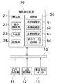
- FIG. 1 is a block diagram of an electronic chart display network system including a chart display device according to an embodiment of the present invention.
- 5 is a flowchart showing registration processing performed by the calculation unit. The figure which shows the screen at the time of receiving specification of setting distance or required time. The figure which shows the screen at the time of receiving registration of the distance between touches.
- 6 is a flowchart showing processing such as changing to an additional scale and switching of a display mode performed by a calculation unit.
- the figure which shows a mode that the distance on a chart is measured using the space
- the figure which shows a mode that the distance on a chart is measured using the space
- FIG. 1 is a block diagram of an electronic chart display network system 1 including a chart display device 20 of the present embodiment.
- the electronic chart display network system 1 is mounted on a ship to display various types of information necessary for navigation. As shown in FIG. 1, the electronic chart display network system 1 includes a GPS receiver 11, an AIS receiver 12, a heading sensor 13, and a chart display device 20. Further, each marine device constituting the electronic chart display network system 1 is connected via the marine network 10.
- the marine network 10 is a network for communicating between marine devices in the same ship.
- the marine devices can exchange the detected information and the like via the marine network 10.
- the marine network 10 is a LAN (Local Area Network), and specifically, Ethernet (registered trademark), CAN (Controller Area Network), or NMEA (National Marine Electronics Association) can be adopted. Note that at least one of the GPS receiver 11, the AIS receiver 12, and the heading sensor 13 may be directly connected to the chart display device 20 by a cable or the like instead of the marine network 10. Good.
- the GPS receiver 11 receives positioning signals from GPS satellites via a GPS antenna (not shown).
- the GPS receiver 11 determines the position of its own ship (specifically, the position of the GPS antenna, the absolute position of the earth reference) based on this positioning signal, and transmits it to the chart display device 20.
- a receiver for determining the position of the ship using a GNSS other than the GPS (for example, GLONASS, GALILEO, etc.).
- the AIS receiver 12 is configured to receive an AIS signal transmitted by another ship.
- AIS Univeral Shipborne Automatic Identification System: A ship automatic identification system
- the AIS receiver 12 receives and analyzes an AIS signal transmitted by another ship to acquire information (AIS information) such as an absolute position and a destination of the other ship.
- the AIS receiver 12 transmits the acquired AIS information to the chart display device 20.
- the AIS information includes the other ship's name, absolute position, course, and destination.
- the analysis processing of the AIS signal may be performed on the chart display device 20 side.
- the heading sensor 13 is configured to detect the heading of the own ship (the direction in which the bow of the own ship is facing) in an absolute direction relative to the earth.
- the heading sensor 13 can use, for example, a magnetic heading sensor, a GPS compass, a gyro compass, or the like.
- the heading sensor 13 transmits the detected heading to the chart display device 20.
- the chart display device 20 is a device for displaying an electronic chart.
- the chart display device 20 of the present embodiment is relatively large (for example, the screen size is 30 inches or more or 40 inches or more), and is arranged so that the displayed screen is parallel to the horizontal direction.
- the chart display device 20 may have a screen size of less than 30 inches, or may have a configuration in which the screen to be displayed is arranged vertically or at an angle close to perpendicular.
- the horizontal direction is a concept including a plane parallel to the floor surface on which the chart display device 20 is installed, in addition to the plane perpendicular to the vertical direction. Furthermore, in the present specification, the horizontal direction does not have to be strictly perpendicular to the vertical direction or parallel to the floor surface, and includes, for example, an angle of 10 ° or less. Also, if the tilt angle of the screen of the chart display device 20 can be changed, it is possible to change the tilt angle so that the screen can be oriented horizontally, “The screen of the chart display device 20 is parallel to the horizontal direction It shall correspond to "placed in”.
- the chart display device 20 includes a display unit 21, an operation detection unit 22, an input unit 23, a storage unit 24, and a calculation unit 25.
- the display unit 21 is a portion having a screen on which electronic data can be displayed using figures and characters.
- the display unit 21 is, for example, a liquid crystal display, but may be a plasma display, an organic EL display, or the like.
- the screen of the display unit 21 is a rectangle (rectangle), but may be a different shape (for example, a square).
- the operation detection unit 22 is a capacitive touch panel or the like disposed on the screen of the display unit 21.
- the operation detection unit 22 can detect a touch operation (touch gesture) performed by the user touching his / her finger or an operating tool on the screen.
- a touch operation touch gesture
- hardware keys may be arranged.
- the operation detection unit 22 outputs an electrical signal corresponding to the touch operation performed by the user (corresponding to the change in the touch position).
- the drag operation is an operation of moving the finger or fingers touching the screen in a predetermined direction without releasing the finger from the screen.
- a process of scrolling the chart is associated with this drag operation.
- the pinch operation is an operation of bringing the fingers close to each other (pinch-in operation) or an operation of separating the fingers (pinch-out operation) without releasing the two fingers touched on the screen from the screen.
- This pinch operation is associated with processing to change the scale of the chart.
- the rotation operation an operation in which two fingers are touched on the screen and the other is rotated around one finger, or the two fingers touched are the rotation centers of the centers of the two fingers. Is an operation to rotate.
- This rotation operation is associated with processing for rotating the chart (changing the orientation of the chart relative to the screen orientation).
- the electric signal output from the operation detection unit 22 is input to the input unit 23. Further, in addition to the electric signal output from the operation detection unit 22, the input unit 23 may be configured to receive a signal output from an apparatus outside the chart display device 20. Specifically, the input unit 23 is an input port or the like to which a signal output from the operation detection unit 22 or a signal output from an external device is input. In response to the signal input to the input unit 23, the operation unit 25 performs processing.
- the storage unit 24 stores chart information, a point registered by the user, a route created by the user, an additional reduced scale (details will be described later) registered by the user, and various programs (for example, a chart display program).
- the storage unit 24 is a non-volatile memory such as a hard disk, a flash memory (a flash disk, a memory card or the like), or an optical disk.
- the storage unit 24 may be configured of one piece of hardware described above, or may be configured of a plurality of pieces of hardware. For example, only chart information may be stored on the optical disc, and other information may be stored on the hard disk.
- the arithmetic unit 25 is an arithmetic processing unit such as an FPGA, an ASIC, or a CPU.
- the calculation unit 25 is configured to execute various processes related to the chart display device 20 by reading out a program stored in the storage unit 24 or the like to a RAM or the like and executing the program.
- the display processing unit 61, the registration processing unit 62, the change processing unit 63, and the display mode switching unit 64 are realized by the calculation unit 25.
- the display processing unit 61 performs a process of displaying the chart, the route, and the like stored in the storage unit 24 on the display unit 21 according to the signal input to the input unit 23, as shown in FIG.
- the land is indicated by dots
- the sea is indicated by plain
- the route is indicated by 30.
- menu buttons for creating and displaying the route 30 are superimposed on the chart.
- the display processing unit 61 performs processing of displaying various information received from the GPS receiver 11, the AIS receiver 12, and the heading sensor 13 on the display unit 21. Specifically, as shown in FIG. 3, the display processing unit 61 displays own ship basic information 31 indicating the ship position and heading and the like in text, and the ship position and heading on the chart as symbols.
- the display unit 21 displays the own ship symbol 32 and an AIS symbol 33 in which the positions and the like of other ships obtained from the AIS information are indicated by symbols on the chart.
- the display processing unit 61 performs processing for displaying the result of measuring the distance on the chart in the same manner as the divider using the user's hand (such as an individual measurement distance 56 and a total measurement distance 57 described later).
- this process will be described in detail.
- the divider interval is adjusted to the predetermined length on the chart, how many times the measurement object corresponds to the divider interval By determining, the distance on the chart of the measurement object is measured.
- the divider spacing is adjusted to a user-friendly number (eg, a multiple of five, etc.).
- the measurement method using a divider is applied to the touch panel type marine chart display device 20, for example, a scale is displayed on the electronic chart, and the distance between the user's two fingers is set to a predetermined length on the chart using the scale. There is a way to match it. However, since it is difficult to keep the two fingers open at the same distance, the measurement accuracy tends to be low when measuring by this method. In particular, when it is necessary to move a finger or the like on the screen when it is necessary to measure how many times the distance between the fingers corresponds to the measurement object, the distance between the two fingers can not be maintained, and the measurement accuracy may be reduced. There is sex.
- the distance between the user's two fingers and the corresponding chart is displayed at a scale (hereinafter referred to as an additional scale) that matches the distance of.
- an additional scale a scale that matches the distance of.
- FIG. 2 is a flowchart showing the registration process performed by the calculation unit 25 (registration processing unit 62).
- FIG. 3 is a diagram showing a screen when receiving the specification of the set distance or the required time.
- FIG. 4 is a diagram showing a screen when accepting registration of the inter-touch distance.
- the following description will be made by taking as an example the spacing between the thumb and forefinger of the user (more specifically, the spacing between the fingertips, hereinafter the same), but the spacing between the other two fingers may be used.
- registration of the additional scale is performed using the distance between the two fingers of one hand in the chart display device 20, but the addition is possible even if the distance between the two fingers is one hand. Registration of the scale is possible.
- the registration processing unit 62 receives an instruction to register the additional scale (when an electric signal to that effect is input to the input unit 23), the registration processing unit 62 receives the specification of the set distance or the required time ( S101).
- the set distance is a distance on the chart that corresponds to the distance between two fingers.
- the required time is the time taken to move the distance on the chart indicated by the distance between two fingers.
- the registration processing unit 62 displays on the display unit 21 a first window 50 for specifying the set distance or the required time.
- the first window 50 includes a set distance specification field 51 and a required time specification field 52. Only one of the set distance and the required time may be set. Therefore, in FIG. 3, since the set distance is being specified, the required time specification field 52 is grayed out.
- the required time specification column 52 is configured to be able to specify both the required time and the boat speed, it is a method of specifying the ship speed in advance and specifying only the required time in the required time specification column 52. Good.
- the designation of the set distance, the required time, the ship speed, etc. may be a method of selecting a desired value from a plurality of values as shown in FIG.
- the method of designating the set distance may be a method of selecting two points on the chart and setting the distance on the chart between the two points as the set distance instead of the method of inputting or selecting the numerical value.
- the registration processing unit 62 receives the inter-touch distance (S102).
- the inter-touch distance is the distance on the screen of the two touch positions.
- the distance on the screen may be described in units such as the number of pixels, or may be described in units such as mm.
- the registration processing unit 62 displays a second window 53 for receiving the inter-touch distance.
- the reference scale 54 of FIG. 4 is not displayed.
- the user performs two touches on the second window 53 in a desired finger opening manner.
- the reference mark 54 is displayed between the two touch positions.
- the reference scale 54 is a scale and a numerical value indicating the set distance or the required time designated in the previous process. By displaying the reference scale 54, it can be intuitively grasped that the set distance or the like specified in the previous step is associated with the finger interval. Note that the display of the reference mark 54 can be omitted.
- the registration processing unit 62 can also receive the distance between touches even when two touches on the screen are simultaneously detected. Alternatively, the registration processing unit 62 may detect the first touch on the screen first, and may detect the second touch on the screen while detecting the first touch. Even the distance between touches can be accepted. In addition, the registration processing unit 62 may be configured to receive the distance between touches when two touch positions are detected, or two touch positions are detected and then at least one is not detected. It may be configured to receive an inter-touch distance at a point in time (that is, at a point of time when the finger is released). The registration processing unit 62 may be configured to receive two touches on the chart without displaying the second window 53.
- the registration processing unit 62 calculates and registers the additional scale (S103).
- the additional scale is a scale that associates the set distance or the required time specified in step S101 with the inter-touch distance received in step S102. Therefore, the additional scale can be calculated by performing operations such as dividing the distance between touches by the set distance.
- the required time is specified instead of the set distance
- the distance (set distance) to move during the required time at the specified boat speed is calculated.
- the registration processing unit 62 stores the calculated additional scale in the storage unit 24.
- FIG. 5 An example of a plurality of additional scales stored in the storage unit 24 is shown in FIG.
- FIG. 5 An example of a plurality of additional scales stored in the storage unit 24 is shown in FIG.
- a to C inter-touch distances
- the inter-touch distance differs depending on the size of the user's hand, etc.
- an ID is attached to each inter-touch distance (ID is used to distinguish the inter-touch distance) .
- a plurality of set distances are registered in the same inter-touch distance. In this way, it is possible to cope with both the case where the same user wants to increase the scale and measure short distances, and the case where the same user wants to decrease the scale and measure long distances.
- a plurality of additional scales having different inter-touch distances or set distances (required times) are registered, when displaying the chart at the additional scales, for example, a list of additional scales and It is possible to display the ID etc. and select the additional scale to apply.
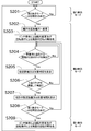
- FIG. 6 is a flowchart showing processing such as changing to the additional scale and switching of the display mode performed by the calculation unit 25.
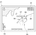
- FIG. 7 is a diagram showing how the distance on the chart is measured using the finger distance in the second display mode.
- FIG. 8 is a diagram showing how the distance on the chart is measured using the finger interval multiple times in the second display mode.
- the display mode switching unit 64 can switch between a first display mode in which the scale can be freely changed and a second display mode in which the chart is displayed at an additional scale.
- the first display mode is a general chart display method, and is a display mode used for various applications.
- the second display mode the chart may be displayed at an additional scale, and the main purpose is to measure the distance on the chart by the user's hand.
- the chart display device 20 according to the present embodiment has a separate display mode for displaying the chart at an additional scale, and the processing for the touch operation of the user is different according to the display mode (for example, in the second display mode). Invalidation of change of scale due to pinch operation, etc.).
- the chart display device 20 may be configured to display a chart without dividing the display mode.
- additional scales are displayed as candidates in addition to the existing scale (general scale such as 1 / 50,000, 1 / 200,000, etc.) at the time of selection of the scale.
- there may be a dedicated button eg, a button displayed on the screen
- the calculation unit 25 determines whether or not an instruction to switch to the second display mode has been issued (S201). When there is an instruction to switch to the second display mode, the display mode switching unit 64 switches to the second display mode, and the change processing unit 63 changes the scale to the additional scale (S202). If multiple additional scales are registered, change to the specified additional scale. Further, in the second display mode, in order to make it easy to understand that the current scale is the additional scale, the set distance scale 55 is displayed as shown in FIG. The set distance scale 55 has a length corresponding to the set distance associated with the additional scale.
- a set distance (numeric value), an ID indicating a user, an icon of a hand for easy understanding that it is a mode to measure by hand, and the like are displayed. Only a part of these may be displayed. If the required time is set instead of the set distance, the required time is displayed.
- the calculation unit 25 invalidates the change in scale due to the pinch operation and invalidates the rotation of the chart due to the rotation operation (S203).
- the scale of the chart by pinch operation is effective in the second display mode, when two points on the chart are touched to measure the distance (or the finger touching the screen after measuring the distance, etc. May be slightly scaled.
- rotation of the chart by the rotation operation is effective, it is conceivable that the chart rotates frequently when measuring the distance. For example, the user touches the chart with the thumb and forefinger, rotates the forefinger centering on the thumb while maintaining the position of the thumb, changes the position of the forefinger, and measures the length of the broken line (by pivoting). If so, the chart may rotate.
- the change of the scale by the pinch operation and the rotation of the chart by the rotation operation are invalidated.
- the calculation unit 25 calculates the distance between touches when there are two touch positions.
- the inter-touch distance detected during display of the chart is referred to as “detected touch distance”.
- the inter-touch distance received in step S102 is referred to as the “registered touch distance”.
- the computing unit 25 determines whether two touch positions at intervals close to the registered touch distance have been detected (whether the detected touch distance approximates the registered touch distance) (S204).
- the display processing unit 61 determines that the detected touch distance is close to the registered touch distance (in the case of Yes in step S204), as shown in FIG. 7, the proximity of the detected touch position
- the single measurement distance 56 is displayed on (S205).
- the single measurement distance 56 is a numerical value indicating the same length as the set distance.
- the user registers the distance between two fingers in a highly reproducible manner between the touch distances, it is almost impossible to reproduce exactly the same touch distance as at the time of registration.
- the single measurement distance 56 is displayed even when the distance between the registration touch and the touch distance is similar.
- the single measurement distance 56 By displaying the single measurement distance 56, the user can intuitively understand the distance to be measured.
- the single measurement distance 56 may be configured to display a scale in addition to or instead of the numerical value.
- the required time is set instead of the set distance, the required time is displayed. Note that both of the set distance and the required time may be displayed.
- the calculation unit 25 determines whether or not the touch positions of two points at intervals approximate to the registered touch distance are continuously detected (S206). Specifically, the calculation unit 25 is configured to: (1) all of the continuously detected detected touch distances approximate to the registered touch distance; and (2) continuously detected touch positions. Are continuous (for example, when three touches are made, the position of the second touch of the first touch and the position of the first touch of the second touch coincide, and the second The position of the second point of the touch and the position of the first point of the third touch coincide with each other. If the display processing unit 61 determines that both of these conditions are satisfied, the display processing unit 61 displays a total measurement distance 57 corresponding to the total of continuously detected detected touch distances as shown in FIG. 8 (S207). If the required time is set instead of the set distance, the total required time is displayed. Note that both of the total of the set distances and the total of the required time may be displayed.
- the calculation unit 25 determines whether or not there is an instruction to switch to the first display mode (S208). When an instruction to switch to the first display mode is issued, the calculation unit 25 switches the display mode to the first display mode while the display mode switching unit 64 validates the change in scale by the pinch operation and also performs the rotation operation. The rotation of the chart according to is activated (S209). Then, the determination in step S201 is performed again.
- the chart display device 20 includes the display unit 21, the operation detecting unit 22, the registration processing unit 62, and the change processing unit 63, and the chart display program is executed.
- the display unit 21 has a screen and displays a chart on the screen.
- the operation detection unit 22 detects a touch operation on the screen.
- the registration processing unit 62 registers, as an additional scale, a scale at which the distance between two touches on the screen matches the set distance on the chart.
- the change processing unit 63 changes the scale of the chart to the additional scale.
- the additional scale can be registered using two touches at arbitrary intervals.
- the user can register the additional scale by using the distance between two fingers when the hand is spread.
- the chart can be displayed at an additional scale depending on the size of the hand etc. By displaying the chart at this registered additional scale, the user's hand can be used to measure the distance on the chart in the same manner as the divider.
- the registration processing unit 62 receives designation of a distance, and sets the designated distance as a set distance.
- the additional scale can be registered using the set distance desired by the user.
- the registration processing unit 62 receives specification of the required time, and sets a distance to move during the required time at the specified boat speed as a set distance.
- an additional scale can be registered using the desired time desired by the user.
- the display mode switching unit 64 switches between the first display mode and the second display mode.
- the first display mode displays a chart, and accepts a change in scale by pinch operation on the screen.
- the second display mode displays the chart at an additional scale and does not accept a change in scale due to a pinch operation.
- the rotation of the chart by the rotation operation to the screen is received.
- the rotation of the chart by the rotation operation to the screen is not accepted.
- the distance between the detection touches which is the distance between two touches detected by the operation detection unit 22 is If it is determined in the registration process that the distance between the two touch points received is similar to the inter-touch distance, it is necessary to take the set distance and the movement of the set distance near the detected touch position. Display at least one of the hours.
- the set distance and the like are displayed by touching with the finger interval or the like received in the registration process, so that the user can easily measure the distance on the chart using his hand.
- the set distance even when the detected touch distance is slightly different from the registered touch distance, it is easy to measure how many times the measurement target corresponds to the set distance or the like.
- the display processing unit 61 detects that the continuously detected touch distance is close to the registered touch distance, and the detected touch positions are continuous. If yes, at least one of the set distance and the required time corresponding to the sum of continuously detected detected touch distances is displayed.
- the chart display device 20 of the present embodiment includes the storage unit 24 that stores a plurality of additional scales.
- the change processing unit 63 changes the scale of the chart to the designated additional scale among the plurality of additional scales.
- a plurality of set distances are registered in the storage unit 24 for one inter-touch distance.
- the set distances are registered in the storage unit 24 for a plurality of inter-touch distances.
- step S101 and step S102 may be switched.
- the inter-touch distance is received first, and the set distance or the required time corresponding to the inter-touch distance is specified next.
- the chart display device 20 is disposed so that the screen is parallel to the horizontal plane, but may be disposed at different angles.
- the present invention is also applicable to a display device capable of displaying a radar image, a fish finder image, etc. Is applicable.
- Reference Signs List 20 sea map display device 21 display unit 22 operation detection unit 23 input unit 24 storage unit 25 calculation unit 61 display processing unit 62 registration processing unit 63 change processing unit 64 display mode switching unit
Abstract
【課題】ディバイダを用いて行っていた距離の測定方法を電子海図上で行うことが可能な海図表示装置を提供する。 【解 決手段】海図表示装置20は、表示部21と、操作検出部22と、登録処理部62と、変更処理部63と、を備える。表示部21は、画面を有し、当該画面に海 図を表示する。操作検出部22は、画面へのタッチ操作を検出する。登録処理部62は、画面への2点のタッチを受付け、当該タッチ位置の画面上の距離が海図 上の設定距離に一致する縮尺を追加縮尺として登録する。変更処理部63は、海図の縮尺を追加縮尺に変更する。
Description
本発明は、主として、海図を表示する海図表示装置に関する。
特許文献1には、海図を含む航海情報を表示する表示装置が開示されている。この表示装置は、タッチパネルとして構成されており、画面へのタッチ操作に基づ いて様々な処理が行われる。例えば、タッチした2本の指を画面から離さずに指同士を近づけたり離したりすることで、海図の縮尺が変更される。また、海図の 表示中に画面上の2点を指でタッチすることで、2点のタッチ位置間の海図上の距離が画面に表示される。
ここで、紙の海図を用いて所定の2点間の海図上の距離を測定する場合、初めに海図上の目盛り(例えば緯度目盛り)にディバイダを合わせて、ディバイダの間 隔を海図上の所定長さ(例えば1NM)に合わせる。そして、測定対象がディバイダの間隔(即ち海図上の所定長さ)の何倍に相当するかを求めて計算を行うこ とで、測定対象の海図上の距離を測定することができる。
一方で、特許文献1のような電子海図では、上述のように海図上にタッチ操作を行うだけで測定対象の海図上の距離を測定することができる。しかし、従前の測定方法に慣れたユーザにとっては、このような操作が分かりにくいことがある。
本発明は以上の事情に鑑みてされたものであり、その主要な目的は、ディバイダを用いて行っていた距離の測定方法を電子海図上で行うことが可能な海図表示装置を提供することにある。
本発明の解決しようとする課題は以上の如くであり、次にこの課題を解決するための手段とその効果を説明する。
本発明の観点によれば、以下の構成の海図表示装置が提供される。即ち、この海図表示装置は、表示部と、操作検出部と、登録処理部と、変更処理部と、を備え る。前記表示部は、画面を有し、当該画面に海図を表示する。前記操作検出部は、前記画面へのタッチ操作を検出する。前記登録処理部は、前記検出した画面へ の2点のタッチ間距離が海図上の設定距離に一致する縮尺を追加縮尺として登録する。前記変更処理部は、海図の縮尺を前記追加縮尺に変更する。
これにより、任意の間隔の2点のタッチを用いて追加縮尺を登録することができるので、例えば指を広げたときの2本の指の間隔を用いて追加縮尺の登録を行う ことで、ユーザの手等の大きさに応じた追加縮尺で海図を表示できる。この登録された追加縮尺で海図を表示することで、ユーザの手を用いてディバイダと同様 の方法で海図上の距離を測定することができる。
次に、図面を参照して本発明の実施形態を説明する。初めに、図1を参照して、電子海図表示ネットワークシステム1について説明する。図1は、本実施形態の海図表示装置20を含む電子海図表示ネットワークシステム1のブロック図である。
電子海図表示ネットワークシステム1は、船舶に搭載されて航海に必要な各種の情報を表示するためのものである。図1に示すように、電子海図表示ネットワー クシステム1は、GPS受信機11と、AIS受信機12と、船首方位センサ13と、海図表示装置20と、を含んで構成されている。また、電子海図表示ネッ トワークシステム1を構成する各舶用機器は、舶用ネットワーク10を介して接続されている。
舶用ネットワーク10は、同 一の船舶内の舶用機器同士で通信を行うためのネットワークである。舶用機器同士は、検出した情報等を、舶用ネットワーク10を介してやり取りすることがで きる。舶用ネットワーク10はLAN(Local Area Network)であり、具体的にはイーサネット(登録商標)、 CAN(Controller Area Network)、又は、NMEA(National Marine Electronics Association)を採用することができる。なお、GPS受信機11、AIS受信機12、及び船首方位センサ13のうち少なくとも1つについて、舶 用ネットワーク10を介してではなく、海図表示装置20と直接的にケーブル等で接続されていてもよい。
GPS受信機11 は、GPS衛星からの測位信号を、図略のGPSアンテナを介して受信する。GPS受信機11は、この測位信号に基づいて自船の位置(詳細には、GPSアン テナの位置、地球基準の絶対位置)を求めて海図表示装置20へ送信する。なお、GPS受信機11に代えて、GPS以外のGNSS(例えば、GLONASS やGALILEO等)を用いて自船の位置を求める受信機を用いることもできる。
AIS受信機12は、他船が送信した AIS信号を受信するように構成されている。AIS(Univeral Shipborne Automatic Identification System:船舶自動識別システム)とは、自船の位置情報や航行情報等を無線通信によって周囲に送信するシステムである。AIS受信機12は、他船が送 信したAIS信号を受信して解析することで、他船の絶対位置及び目的地等の情報(AIS情報)を取得する。AIS受信機12は、取得したAIS情報を海図 表示装置20へ送信する。AIS情報には、他船の名称、絶対位置、針路、及び目的地等が含まれている。なお、AIS信号の解析処理は、海図表示装置20側 で行ってもよい。
船首方位センサ13は、自船の船首方位(自船の船首が向いている方向)を、地球基準の絶対的な方位で検 出するように構成されている。船首方位センサ13は、例えば磁気方位センサ、GPSコンパス、ジャイロコンパス等を利用することができる。船首方位センサ 13は、検出した船首方位を海図表示装置20へ送信する。
海図表示装置20は、電子海図を表示するための装置である。本 実施形態の海図表示装置20は、比較的大型(例えば、画面サイズが30インチ以上又は40インチ以上)であり、表示される画面が水平方向に平行となるよう に配置される。なお、海図表示装置20は、画面サイズが30インチ未満であってもよいし、表示される画面が垂直又は垂直に近い角度で配置される構成であっ てもよい。
また、本明細書において、水平方向とは、鉛直方向に垂直な面の他、海図表示装置20の設置先の床面に平行な面 も含む概念である。また、本明細書において、水平方向とは、厳密に鉛直方向に垂直又は床面に平行でなくても良く、例えば10°以下の角度をなしている場合 も含むものとする。また、海図表示装置20の画面の傾斜角度が変更可能な場合は、傾斜角度を変更して水平方向に向けることが可能であれば、「海図表示装置 20の画面が水平方向に平行となるように配置される」に該当するものとする。
図1に示すように、海図表示装置20は、表示部21と、操作検出部22と、入力部23と、記憶部24と、演算部25と、を備える。
表示部21は、電子データを図及び文字等を用いて表示可能な画面を有する部分である。表示部21は、例えば液晶ディスプレイであるが、プラズマディスプレ イ又は有機ELディスプレイ等であってもよい。本実施形態では、表示部21の画面は長方形(矩形)であるが、異なる形状(例えば正方形)であってもよい。
操作検出部22は、表示部21の画面に配置された静電容量式等のタッチパネルである。操作検出部22は、ユーザが自身の指又は操作具等を画面にタッチさせ て行ったタッチ操作(タッチジェスチャ)を検出可能である。なお、タッチパネルに加えてハードウェアキーが配置されていてもよい。操作検出部22は、ユー ザが行ったタッチ操作に応じた(タッチ位置の変化に応じた)電気信号を出力する。
タッチ操作としては、1点又は複数点の タッチを行う操作以外にも、例えば、「ドラッグ操作」、「ピンチ操作」、「回転操作」がある。ドラッグ操作とは、画面にタッチした指(1本又は複数本)を 画面から離さずに所定の方向へ移動させる操作である。このドラッグ操作には、海図をスクロールさせる処理が対応付けられている。ピンチ操作とは、画面に タッチした2本の指を画面から離さずに、指同士を近づける操作(ピンチイン操作)又は指同士を離す操作(ピンチアウト操作)である。このピンチ操作には、 海図の縮尺を変更する処理が対応付けられている。回転操作とは、画面に2本の指をタッチし、一方の指の周りを他方の指が回転する操作、あるいは、タッチし た2本の指を、この2本の指の中心を回転中心として回転させる操作である。この回転操作には、海図を回転させる(画面の向きに対して海図の方位を変更す る)処理が対応付けられている。
入力部23には、操作検出部22が出力した電気信号が入力される。また、入力部23に は、操作検出部22が出力した電気信号に加えて、海図表示装置20の外部の機器が出力した信号が入力される構成であってもよい。入力部23は、具体的に は、操作検出部22が出力した信号、外部の機器が出力した信号が入力される入力ポート等である。入力部23に入力された信号に応じて、演算部25が処理を 行う。
記憶部24は、海図情報、ユーザが登録した地点、ユーザが作成したルート、ユーザが登録した追加縮尺(詳細は後 述)、及び各種プログラム等(例えば海図表示プログラム)を記憶している。記憶部24は、ハードディスク、フラッシュメモリ(フラッシュディスク及びメモ リーカード等)、又は光ディスク等の不揮発性メモリである。記憶部24は、上記の1つのハードウェアから構成されていてもよいし、複数のハードウェアから 構成されていてもよい。例えば、海図情報のみが光ディスクに記憶され、その他の情報がハードディスクに記憶されていてもよい。
演算部25は、FPGA、ASIC、又はCPU等の演算処理装置である。演算部25は、記憶部24等に記憶されたプログラムをRAM等に読み出して実行す ることで、海図表示装置20に関する様々な処理を実行できるように構成されている。これにより、演算部25によって、表示処理部61、登録処理部62、変 更処理部63、及び表示モード切替部64が実現される。
表示処理部61は、入力部23に入力された信号に応じて、図3に 示すように、記憶部24に記憶された海図及びルート等を表示部21に表示する処理を行う。図3では、陸地がドットで示されており、海が無地で示されてお り、ルートが符号30で示されている。なお、本実施形態では、ルート30の作成及び表示設定等を行うメニューボタンが海図上に重畳されている。また、表示 処理部61は、GPS受信機11、AIS受信機12、及び船首方位センサ13から受信した各種情報を表示部21に表示する処理等を行う。具体的には、図3 に示すように、表示処理部61は、自船位置及び船首方位等をテキストで示した自船基本情報31と、自船位置及び船首方位を海図上にシンボルで示した自船シ ンボル32と、AIS情報から得られた他船の位置等を海図上にシンボルで示したAISシンボル33と、を表示部21に表示する。
また、表示処理部61は、ユーザの手を用いてディバイダと同様の方法で海図上の距離を測定した結果(後述の単独測定距離56及び合計測定距離57等)を表 示する処理を行う。以下、この処理について詳細に説明する。上述したように、紙の海図を用いて海図上の距離を測定する場合、ディバイダの間隔を海図上の所 定長さに合わせた後に、測定対象がディバイダの間隔の何倍に相当するかを求めることで、測定対象の海図上の距離を測定する。一般的に、ディバイダの間隔 は、ユーザが分かり易い数値(例えば5の倍数等)に合わせられる。
ディバイダを用いた計測方法をタッチパネル式の海図表 示装置20に適用する場合、例えば電子海図上に目盛りを表示し、その目盛りを用いて、ユーザの2本の指の間隔を海図上の所定長さに合わせる方法が考えられ る。しかし、2本の指を同じ間隔で開き続けることは困難であるため、この方法で測定する場合は測定精度が低くなり易い。特に、測定対象が指の間隔の何倍に 相当するかを求める際には、画面上で指等を動かす必要があるため、2本の指の間隔を維持できなくなって測定精度が低下する可能性がある。
以上を考慮し、本実施形態では、既存の縮尺で示された海図上の目盛りにユーザの2本の指の間隔を合わせるのではなく、ユーザの2本の指の間隔とそれに対応 する海図上の距離とが合致する縮尺(以下、追加縮尺)で海図を表示する。これにより、ユーザは所望の指の開き方を用いて測定を行うことができるので、指の 間隔の再現性が高い指の開き方(例えば所定の2本の指を限界まで開く方法)を用いることができる。そのため、2本の指の間隔が一度維持できなくなった場合 でも、同じ間隔を再現できるため、測定精度が低下することを防止できる。
初めに、2本の指の間隔を基準として追加縮尺を 登録する登録処理について説明する。図2は、演算部25(登録処理部62)が行う登録処理を示すフローチャートである。図3は、設定距離又は所要時間の指 定を受け付ける際の画面を示す図である。図4は、タッチ間距離の登録を受け付ける際の画面を示す図である。なお、以下ではユーザの親指と人差し指の間隔 (より詳細には指先の間隔、以下同じ)を例として説明するが、他の2本の指の間隔を用いてもよい。また、本実施形態では海図表示装置20では片手の2本の 指の間隔を用いて追加縮尺の登録を行うことを想定しているが、片手の2本の指の間隔以外であっても追加縮尺の登録は可能である。
初めに、登録処理部62は、追加縮尺の登録を行う旨の指示を受け付けた場合(入力部23にその旨の電気信号が入力された場合)、設定距離又は所要時間の指 定を受け付ける(S101)。設定距離とは、2本の指の間隔に対応付ける海図上の距離である。所要時間とは2本の指の間隔が示す海図上の距離を移動するた めに掛かる時間である。
具体的には、登録処理部62は、図3に示すように、設定距離又は所要時間を指定するための第1ウ インドウ50を表示部21に表示する。第1ウインドウ50には、設定距離指定欄51と所要時間指定欄52とが含まれている。設定距離と所要時間は何れか一 方のみを設定すればよい。従って、図3では、設定距離を指定する途中であるため、所要時間指定欄52がグレーアウトしている。所要時間指定欄52は、所要 時間と船速の両方を指定可能な構成であるが、船速を事前に指定しておき、所要時間指定欄52では所要時間のみを指定する方法であってもよい。設定距離、所 要時間、又は船速等の指定は、図3に示すように複数の値から所望の値を選択する方法であってもよいし、ユーザによる所望の値の入力を受け付ける方法であっ てもよい。また、設定距離を指定する方法は、数値を入力又は選択する方法に代えて、海図上の2点を選択し当該2点間の海図上の距離を設定距離とする方法で あってもよい。
次に、登録処理部62は、タッチ間距離の受付けを行う(S102)。タッチ間距離とは、2点のタッチ位置の画面上の距離である。画面上の距離は、ピクセル数等の単位で記述されていてもよいし、mm等の単位で記述されていてもよい。
具体的には、登録処理部62は、図4に示すように、タッチ間距離を受け付けるための第2ウインドウ53を表示する。この時点では図4の参照目盛り54は表 示されていない。ユーザは所望の指の開き方で第2ウインドウ53に2点のタッチを行う。これにより、2点のタッチ位置の間に参照目盛り54が表示される。 参照目盛り54は、前工程で指定した設定距離又は所要時間を示す目盛り及び数値である。参照目盛り54が表示されることで、前工程で指定した設定距離等と 指の間隔とが対応付けられることが直感的に把握できる。なお、参照目盛り54の表示は省略することもできる。
また、登録 処理部62は画面への2点のタッチを同時に検出した場合であってもタッチ間距離を受付可能である。あるいは、登録処理部62は、初めに画面への1点のタッ チを検出し、当該1点目のタッチを検出している状態で画面への2点目のタッチを検出した場合であってもタッチ間距離を受付可能である。また、登録処理部 62は、2点のタッチ位置を検出した時点のタッチ間距離を受け付ける構成であってもよいし、2点のタッチ位置が検出されてその後に少なくとも一方が非検出 となった時点(即ち指を離した時点)のタッチ間距離を受け付ける構成であってもよい。また、登録処理部62は、第2ウインドウ53を表示せずに海図上で2 点のタッチを受け付ける構成であってもよい。
次に、登録処理部62は、追加縮尺の算出及び登録を行う(S103)。追加 縮尺は、ステップS101で指定した設定距離又は所要時間と、ステップS102で受け付けたタッチ間距離と、を対応付けた縮尺である。従って、タッチ間距 離を設定距離で除する等の演算を行うことで、追加縮尺を算出できる。なお、設定距離ではなく所要時間が指定された場合は、指定した船速で所要時間の間に移 動する距離(設定距離)を求める。以上のようにして算出した追加縮尺で海図を表示することで、ステップS102で受け付けたタッチ間距離が、海図上では設 定距離等に一致する。登録処理部62は、算出した追加縮尺を記憶部24に記憶する。
また、本実施形態では、複数の追加縮 尺の登録が可能である。図5には、記憶部24に記憶された複数の追加縮尺の例が示されている。図5に示す表には、複数のタッチ間距離(A~C)が記載され ている。タッチ間距離はユーザの手の大きさ等によって異なるため、複数のタッチ間距離を登録可能とすることで、それぞれのユーザに応じた追加縮尺のタッチ 間距離を記憶できる。また、あるユーザの追加縮尺から、別のユーザの追加縮尺に切り替える際の処理を可能にするために、タッチ間距離毎にIDが付されてい る(IDを用いてタッチ間距離を区別する)。また、ID3では、同じタッチ間距離に複数の設定距離が登録されている。これにより、同じユーザが縮尺を大き くして短距離を測定したい場合と、縮尺を小さくして長距離を測定したい場合と、の両方に対応可能である。このように、本実施形態では、タッチ間距離又は設 定距離(所要時間)が異なる複数の追加縮尺が登録されているため、追加縮尺で海図を表示する際には、例えば追加縮尺の一覧及びID等を表示し、適用する追 加縮尺を選択可能である。
次に、登録した追加縮尺で海図を表示する処理について図6から図8を参照して説明する。図6 は、演算部25が行う追加縮尺への変更及び表示モードの切替え等の処理を示すフローチャートである。図7は、第2表示モードで指の間隔を使って海図上の距 離を測定している様子を示す図である。図8は、第2表示モードで指の間隔を複数回使って海図上の距離を測定している様子を示す図である。
表示モード切替部64は、縮尺を自在に変更可能な第1表示モードと、追加縮尺で海図を表示する第2表示モードと、を切替可能である。第1表示モードは一般 的な海図の表示方法であり、様々な用途に用いられる表示モードである。一方で第2表示モードは、追加縮尺で海図を表示することもあり、ユーザの手で海図上 の距離を測定することを主目的とする表示モードである。このように、本実施形態の海図表示装置20は、追加縮尺で海図を表示する表示モードを別途設け、表 示モードに応じてユーザのタッチ操作に対する処理を異ならせる構成(例えば第2表示モードではピンチ操作による縮尺の変更の無効化する等)である。
なお、海図表示装置20は、表示モードを分けずに海図を表示する構成であってもよい。この場合、縮尺の選択時において、既存の縮尺(5万分の1、20万分 の1等の一般的な縮尺)に加えて、追加縮尺が候補として表示される。あるいは、追加縮尺を適用するための専用のボタン(例えば画面上に表示されるボタン) があってもよい。また、ピンチ操作を行って縮尺を変更する際に、追加縮尺の近傍の縮尺になった際に自動的に追加縮尺となるように設定してもよい。なお、表 示モードを分けない場合、ピンチ操作による縮尺の無効化等が行われないため、ピンチ操作を行うことで追加縮尺による海図の表示が終了することとなる。
演算部25は、第1表示モードで海図を表示している際には、第2表示モードへの切替指示がされたか否かを判断している(S201)。第2表示モードへの切 替指示があった場合、表示モード切替部64が第2表示モードへの切替えを行うとともに、変更処理部63が縮尺を追加縮尺に変更する(S202)。なお、複 数の追加縮尺が登録されている場合は、指定された追加縮尺に変更する。また、第2表示モードでは、現在の縮尺が追加縮尺であることを分かり易くするため に、図7に示すように、設定距離目盛り55が表示される。設定距離目盛り55は、追加縮尺に対応付けられた設定距離に応じた長さである。また、設定距離目 盛り55の周囲には、設定距離(数値)、ユーザを示すID、手で計測するモードであることが分かり易くなるための手のアイコン等が表示される。これらのう ち一部のみが表示される構成であってもよい。また、設定距離ではなく所要時間が設定されている場合は所要時間が表示される。
また、演算部25は、第2表示モードでは、ピンチ操作による縮尺変更を無効化するとともに、回転操作による海図の回転を無効化する(S203)。仮に、第 2表示モードにおいて、ピンチ操作による海図の縮尺が有効であれば、距離を測定するために海図上の2点をタッチした際に(又は距離の測定後に画面にタッチ している指等を離した際に)僅かに縮尺が変更される可能性がある。また、仮に回転操作による海図の回転が有効であれば、距離の測定時に海図が頻繁に回転す ることが考えられる。例えば、ユーザが親指及び人差し指で海図にタッチし、親指の位置を維持しつつ親指を中心に人差し指を回転させて人差し指の位置を変化 させて(ピボット回転して)折れ線状の長さを計測する場合、海図が回転する可能性がある。以上により、第2表示モードでは、ピンチ操作による縮尺の変更及 び回転操作による海図の回転を無効化している。
また、演算部25は、第2表示モードで海図を表示している間において、 タッチ位置が2点である場合はタッチ間距離の算出を行う。以下では、海図の表示中に検出されたタッチ間距離を「検出タッチ間距離」と称する。また、ステッ プS102で受け付けたタッチ間距離(追加縮尺の登録に用いられているタッチ間距離、記憶部に記憶されているタッチ間距離)を「登録タッチ間距離」と称す る。
演算部25は、登録タッチ間距離と近似する間隔の2点のタッチ位置を検出したか否か(検出タッチ間距離が登録タッチ 間距離に近似するか否か)を判定する(S204)。表示処理部61は、検出タッチ間距離が、登録タッチ間距離に近似していると判断したときは(ステップ S204でYesの場合は)、図7に示すように、検出されたタッチ位置の近傍に単独測定距離56を表示する(S205)。単独測定距離56は設定距離と同 じ長さを示す数値である。また、ユーザはタッチ間距離の再現性の高い方法で2本の指の間隔を登録しているが、登録時と全く同じタッチ間距離を再現すること は不可能に近いため、検出タッチ間距離が登録タッチ間距離に近似している場合でも単独測定距離56を表示する。単独測定距離56が表示されることで、ユー ザは測定対象の距離が直感的に分かり易くなる。なお、単独測定距離56は数値に加えて又は代えて目盛りを表示する構成であってもよい。また、設定距離では なく所要時間が設定されている場合は所要時間が表示される。なお、設定距離と所要時間の両方を表示する構成であってもよい。
また、演算部25は、登録タッチ間距離と近似する間隔の2点のタッチ位置を連続して検出したか否かを判定する(S206)。具体的には、演算部25は、 (1)連続して検出された検出タッチ間距離が、何れも登録タッチ間距離に近似していることと、(2)連続して検出されたタッチ位置が連続していること(例 えば3回のタッチがされる場合は、1回目のタッチの2点目の位置と、2回目のタッチの1点目の位置とが一致し、更に、2回目のタッチの2点目の位置と3回 目のタッチの1点目の位置が一致すること)の判定を行う。表示処理部61は、これらの両方を満たすと判断した場合、連続して検出された検出タッチ間距離の 合計に相当する合計測定距離57を図8に示すように表示する(S207)。また、設定距離ではなく所要時間が設定されている場合は所要時間の合計が表示さ れる。なお、設定距離の合計と所要時間の合計との両方を表示する構成であってもよい。
また、演算部25は、第1表示モー ドへの切替指示があるか否かを判断している(S208)。演算部25は、第1表示モードへの切替指示があった場合は、表示モード切替部64が第1表示モー ドへの切替えを行うとともに、ピンチ操作による縮尺変更を有効化するとともに、回転操作による海図の回転を有効化する(S209)。そして、また、ステッ プS201の判断を行う。
以上に説明したように、本実施形態の海図表示装置20は、表示部21と、操作検出部22と、登 録処理部62と、変更処理部63と、を備え、海図表示プログラムが実行されることで本発明の海図表示方法が実現される。表示部21は、画面を有し、画面に 海図を表示する。操作検出部22は、画面へのタッチ操作を検出する。登録処理部62は、画面への2点のタッチ間距離が海図上の設定距離に一致する縮尺を追 加縮尺として登録する。変更処理部63は、海図の縮尺を追加縮尺に変更する。
これにより、任意の間隔の2点のタッチを用 いて追加縮尺を登録することができるので、例えば手を広げたときの2本の指の間隔を用いて追加縮尺の登録を行うことで、ユーザの手等の大きさに応じた追加 縮尺で海図を表示できる。この登録された追加縮尺で海図を表示することで、ユーザの手を用いてディバイダと同様の方法で海図上の距離を測定することができ る。
また、本実施形態の海図表示装置20において、登録処理部62は、距離の指定を受け付け、当該指定された距離を設定距離とする。
これにより、所望の距離が入力されたり選択されたりすることで、ユーザが望む設定距離を用いて追加縮尺を登録できる。
また、本実施形態の海図表示装置20において、登録処理部62は、所要時間の指定を受け付け、指定された船速で当該所要時間の間に移動する距離を設定距離とする。
これにより、所望の所要時間が入力されたり選択されたりすることで、ユーザが望む所要時間を用いて追加縮尺を登録できる。
また、本実施形態の海図表示装置20において、表示モード切替部64は、第1表示モードと、第2表示モードと、の切替えを行う。第1表示モードは、海図を 表示し、画面へのピンチ操作による縮尺の変更を受け付ける。第2表示モードは、追加縮尺で海図を表示し、ピンチ操作による縮尺の変更を受け付けない。
これにより、第2表示モードで海図を表示して、ユーザが手を用いて海図上の距離を測定している際に、意図せずに縮尺が追加縮尺から変更されることを防止できる。
また、本実施形態の海図表示装置20において、第1表示モードでは、画面への回転操作による海図の回転を受け付ける。第2表示モードでは、画面への回転操作による海図の回転を受け付けない。
これにより、ユーザが手を用いて海図上の距離を測定している際に、意図せずに海図が回転することを防止できる。
また、本実施形態の海図表示装置20において、表示処理部61は、追加縮尺で海図を表示している場合において、操作検出部22が検出した2点のタッチ間距 離である検出タッチ間距離が、登録処理で受け付けた2点のタッチ間距離である登録タッチ間距離に近似していると判断したときは、検出されたタッチ位置の近 傍に、設定距離及び当該設定距離の移動に掛かる所要時間の少なくとも一方を表示する。
これにより、登録処理で受け付けた 指の間隔等でタッチすることで設定距離等が表示されるので、ユーザが手を用いて海図上の距離を測定し易くなる。特に、検出タッチ間距離が登録タッチ間距離 と僅かに異なっている場合でも設定距離を表示することで、測定対象が設定距離等の何倍に相当するか等の測定が容易となる。
また、本実施形態の海図表示装置20において、表示処理部61は、連続して検出された検出タッチ間距離が、何れも登録タッチ間距離に近似しており、検出さ れたタッチ位置が連続している場合は、連続して検出された検出タッチ間距離の合計に相当する設定距離及び所要時間の少なくとも一方を表示する。
これにより、測定対象が設定距離等の何倍に相当するか等の測定が一層容易となる。
また、本実施形態の海図表示装置20は、複数の追加縮尺を記憶する記憶部24を備える。変更処理部63は、海図の縮尺を、複数の追加縮尺のうち指定された追加縮尺に変更する。
これにより、追加縮尺を記憶することで登録処理を毎回行う必要がない。特に、複数の追加縮尺を記憶することで、登録するユーザ、指の広げ方、及び縮尺等が異なる追加縮尺を事前に登録できるので、それ以降は登録処理が不要となる。
また、本実施形態の海図表示装置20において、記憶部24には、1つのタッチ間距離に対して複数の設定距離が登録されている。
これにより、ユーザが手を用いて海図上の長い距離を測定したい場合と短い距離を測定したい場合との両方に対応することができる。
また、本実施形態の海図表示装置20において、記憶部24には、複数のタッチ間距離に対してそれぞれ設定距離が登録されている。
これにより、例えば複数のユーザの指の間隔を登録できるので、複数のユーザが海図表示装置20を使用する場合であっても、それぞれのユーザが手を用いて海図上の距離を測定できる。
以上に本発明の好適な実施の形態を説明したが、上記の構成は例えば以下のように変更することができる。
図2及び図6のフローチャートの記載は一例であり、処理の順序を入れ替えたり、一部の処理を省略したり、他の処理を追加したりすることもできる。例えば、 ステップS101とステップS102の処理の順序を入れ替えてもよい。この場合、先にタッチ間距離を受け付け、当該タッチ間距離に対応させる設定距離又は 所要時間を次に指定することとなる。
上記実施形態では、海図表示装置20は画面が水平面と平行となるように配置されているが、異なる角度で配置される構成であってもよい。
上記実施形態では、主として電子海図を表示する海図表示装置に本発明を適用する例を説明したが、電子海図に加えてレーダ映像、魚群探知機の映像等を表示可能な表示装置にも本発明を適用できる。
20 海図表示装置
21 表示部
22 操作検出部
23 入力部
24 記憶部
25 演算部
61 表示処理部
62 登録処理部
63 変更処理部
64 表示モード切替部
21 表示部
22 操作検出部
23 入力部
24 記憶部
25 演算部
61 表示処理部
62 登録処理部
63 変更処理部
64 表示モード切替部
Claims (12)
- 画面を有し、当該画面に海図を表示する表示部と、
前記画面へのタッチ操作を検出する操作検出部と、
前記検出した画面への2点のタッチ間距離が海図上の設定距離に一致する縮尺を追加縮尺として登録する登録処理部と、
海図の縮尺を前記追加縮尺に変更する変更処理部と、
を備えることを特徴とする海図表示装置。 - 請求項1に記載の海図表示装置であって、
前記登録処理部は、距離の指定を受け付け、当該指定された距離を前記設定距離とすることを特徴とする海図表示装置。 - 請求項1又は2に記載の海図表示装置であって、
前記登録処理部は、所要時間の指定を受け付け、指定された船速で当該所要時間の間に移動する距離を前記設定距離とすることを特徴とする海図表示装置。 - 請求項1から3までの何れか一項に記載の海図表示装置であって、
海図を表示し、前記画面へのピンチ操作による縮尺の変更を受け付ける第1表示モードと、
前記追加縮尺で海図を表示し、前記ピンチ操作による縮尺の変更を受け付けない第2表示モードと、
の切替えを行う表示モード切替部を更に備えることを特徴とする海図表示装置。 - 請求項4に記載の海図表示装置であって、
前記第1表示モードでは、前記画面への回転操作による海図の回転を受け付け、
前記第2表示モードでは、前記画面への回転操作による海図の回転を受け付けないことを特徴とする海図表示装置。 - 請求項1から5までの何れか一項に記載の海図表示装置であって、
前記追加縮尺で海図を表示している場合において、前記操作検出部が検出した2点のタッチ間距離である検出タッチ間距離が、前記登録処理部で当該追加縮尺を 登録した際の2点のタッチ間距離である登録タッチ間距離に近似しているときは、検出されたタッチ位置の近傍に、前記設定距離及び当該設定距離の移動に掛か る所要時間の少なくとも一方を前記表示部に表示する表示処理部を更に備えることを特徴とする海図表示装置。 - 請求項6に記載の海図表示装置であって、
前記表示処理部は、連続して検出された前記検出タッチ間距離が、何れも前記登録タッチ間距離に近似しており、検出されたタッチ位置が連続している場合は、 連続して検出された前記検出タッチ間距離の合計に相当する前記設定距離及び前記所要時間の少なくとも一方を表示することを特徴とする海図表示装置。 - 請求項1から7までの何れか一項に記載の海図表示装置であって、
複数の前記追加縮尺を記憶する記憶部を備え、
前記変更処理部は、海図の縮尺を、複数の前記追加縮尺のうち指定された追加縮尺に変更することを特徴とする海図表示装置。 - 請求項8に記載の海図表示装置であって、
前記記憶部には、1つのタッチ間距離に対して複数の前記設定距離が登録されていることを特徴とする海図表示装置。 - 請求項8又は9に記載の海図表示装置であって、
前記記憶部には、複数のタッチ間距離に対してそれぞれ前記設定距離が登録されていることを特徴とする海図表示装置。 - 海図が表示された表示部の画面上への2点のタッチ位置の画面上の距離を示すタッチ間距離が海図上の設定距離に一致する縮尺を追加縮尺として登録し、
海図の縮尺を前記追加縮尺に変更して当該海図を前記表示部の画面に表示する処理を含むことを特徴とする海図表示方法。 - 海図が表示された表示部の画面上への2点のタッチ位置の画面上の距離を示すタッチ間距離が海図上の設定距離に一致する縮尺を追加縮尺として登録し、
海図の縮尺を前記追加縮尺に変更して当該海図を前記表示部の画面に表示する処理を含むことを特徴とする海図表示プログラム。
Priority Applications (3)
| Application Number | Priority Date | Filing Date | Title |
|---|---|---|---|
| EP18863659.1A EP3690628B1 (en) | 2017-09-29 | 2018-08-28 | Nautical chart display device, nautical chart display method, and nautical chart display program |
| JP2019544439A JP6874145B2 (ja) | 2017-09-29 | 2018-08-28 | 海図表示装置、海図表示方法、及び海図表示プログラム |
| US16/833,050 US11592296B2 (en) | 2017-09-29 | 2020-03-27 | Nautical chart display device, nautical chart display method, and nautical chart display program |
Applications Claiming Priority (2)
| Application Number | Priority Date | Filing Date | Title |
|---|---|---|---|
| JP2017189292 | 2017-09-29 | ||
| JP2017-189292 | 2017-09-29 |
Related Child Applications (1)
| Application Number | Title | Priority Date | Filing Date |
|---|---|---|---|
| US16/833,050 Continuation-In-Part US11592296B2 (en) | 2017-09-29 | 2020-03-27 | Nautical chart display device, nautical chart display method, and nautical chart display program |
Publications (1)
| Publication Number | Publication Date |
|---|---|
| WO2019065041A1 true WO2019065041A1 (ja) | 2019-04-04 |
Family
ID=65901738
Family Applications (1)
| Application Number | Title | Priority Date | Filing Date |
|---|---|---|---|
| PCT/JP2018/031629 WO2019065041A1 (ja) | 2017-09-29 | 2018-08-28 | 海図表示装置、海図表示方法、及び海図表示プログラム |
Country Status (4)
| Country | Link |
|---|---|
| US (1) | US11592296B2 (ja) |
| EP (1) | EP3690628B1 (ja) |
| JP (1) | JP6874145B2 (ja) |
| WO (1) | WO2019065041A1 (ja) |
Families Citing this family (2)
| Publication number | Priority date | Publication date | Assignee | Title |
|---|---|---|---|---|
| JP2019120494A (ja) * | 2017-12-28 | 2019-07-22 | 古野電気株式会社 | 航行ルート生成装置、航行ルート生成方法および航行ルート生成プログラム |
| JP1697163S (ja) * | 2021-02-26 | 2021-10-18 |
Citations (4)
| Publication number | Priority date | Publication date | Assignee | Title |
|---|---|---|---|---|
| US20080174563A1 (en) * | 2007-01-20 | 2008-07-24 | Lg Electronics Inc. | Electronic device with touch screen and method of displaying information using the same |
| WO2013051051A1 (ja) | 2011-10-03 | 2013-04-11 | 古野電気株式会社 | タッチパネルを有する装置、レーダ装置、プロッタ装置、舶用ネットワークシステム、情報表示方法、及び情報表示プログラム |
| WO2013051047A1 (ja) * | 2011-10-03 | 2013-04-11 | 古野電気株式会社 | 表示装置、表示プログラム、及び表示方法 |
| JP2014006342A (ja) * | 2012-06-22 | 2014-01-16 | Mitsubishi Chemicals Corp | 感光体ユニットの製造方法及び感光体ユニット |
Family Cites Families (9)
| Publication number | Priority date | Publication date | Assignee | Title |
|---|---|---|---|---|
| US3816928A (en) * | 1972-03-21 | 1974-06-18 | E Fessenden | Navigational computer |
| US7620496B2 (en) * | 2004-03-23 | 2009-11-17 | Google Inc. | Combined map scale and measuring tool |
| US20110242136A1 (en) * | 2010-03-31 | 2011-10-06 | Denso Corporation | Map display device |
| WO2013051048A1 (ja) * | 2011-10-03 | 2013-04-11 | 古野電気株式会社 | タッチパネルを有する装置、表示制御プログラム、及び表示制御方法 |
| WO2013121459A1 (ja) * | 2012-02-16 | 2013-08-22 | 古野電気株式会社 | 情報表示装置、表示モード切替方法及び表示モード切替プログラム |
| JP5972629B2 (ja) * | 2012-03-27 | 2016-08-17 | 京セラ株式会社 | 装置、方法、及びプログラム |
| JP6150418B2 (ja) * | 2012-04-27 | 2017-06-21 | 古野電気株式会社 | 情報表示装置、魚群探知機及び情報表示方法 |
| JP5793484B2 (ja) * | 2012-09-24 | 2015-10-14 | 京セラドキュメントソリューションズ株式会社 | 表示入力装置および画像形成装置 |
| WO2018180521A1 (ja) * | 2017-03-28 | 2018-10-04 | アイシン・エィ・ダブリュ株式会社 | 地図表示システムおよび地図表示プログラム |
-
2018
- 2018-08-28 EP EP18863659.1A patent/EP3690628B1/en active Active
- 2018-08-28 WO PCT/JP2018/031629 patent/WO2019065041A1/ja unknown
- 2018-08-28 JP JP2019544439A patent/JP6874145B2/ja active Active
-
2020
- 2020-03-27 US US16/833,050 patent/US11592296B2/en active Active
Patent Citations (4)
| Publication number | Priority date | Publication date | Assignee | Title |
|---|---|---|---|---|
| US20080174563A1 (en) * | 2007-01-20 | 2008-07-24 | Lg Electronics Inc. | Electronic device with touch screen and method of displaying information using the same |
| WO2013051051A1 (ja) | 2011-10-03 | 2013-04-11 | 古野電気株式会社 | タッチパネルを有する装置、レーダ装置、プロッタ装置、舶用ネットワークシステム、情報表示方法、及び情報表示プログラム |
| WO2013051047A1 (ja) * | 2011-10-03 | 2013-04-11 | 古野電気株式会社 | 表示装置、表示プログラム、及び表示方法 |
| JP2014006342A (ja) * | 2012-06-22 | 2014-01-16 | Mitsubishi Chemicals Corp | 感光体ユニットの製造方法及び感光体ユニット |
Non-Patent Citations (1)
| Title |
|---|
| See also references of EP3690628A4 |
Also Published As
| Publication number | Publication date |
|---|---|
| JP6874145B2 (ja) | 2021-05-19 |
| JPWO2019065041A1 (ja) | 2020-11-26 |
| EP3690628A4 (en) | 2021-06-09 |
| EP3690628B1 (en) | 2024-02-07 |
| EP3690628A1 (en) | 2020-08-05 |
| US11592296B2 (en) | 2023-02-28 |
| US20200225042A1 (en) | 2020-07-16 |
Similar Documents
| Publication | Publication Date | Title |
|---|---|---|
| US9678578B2 (en) | Device having touch panel, display control program and display control method | |
| US9671935B2 (en) | Information display device, display mode switching method and display mode switching program | |
| US9354809B2 (en) | Display device, display program and display method | |
| US9727220B2 (en) | Device having touch panel, radar apparatus, plotter apparatus, ship network system, information displaying method and information displaying program | |
| US9753623B2 (en) | Device having touch panel, radar apparatus, plotter apparatus, ship network system, viewpoint changing method and viewpoint changing program | |
| US9182234B2 (en) | Fishfinder data display device, fishfinder device, method of specifying destination and computer readable media | |
| US9500485B2 (en) | Device and method for displaying information | |
| US9157750B2 (en) | Device having touch panel, radar apparatus, plotter apparatus, ship network system, information display method and information display program | |
| US20200265624A1 (en) | Nautical chart display device, nautical chart display method, and nautical chart display program | |
| US11112955B2 (en) | Nautical chart display device, nautical chart display method, and nautical chart display program | |
| JP6874145B2 (ja) | 海図表示装置、海図表示方法、及び海図表示プログラム | |
| US9459716B2 (en) | Device having touch panel, radar apparatus, plotter apparatus, ship network system, information displaying method and information displaying program | |
| EP3431927B1 (en) | Navigational information display device, method of displaying navigational information, and navigational information display program | |
| US9891728B2 (en) | Device having touch panel, radar apparatus, plotter apparatus, ship network system, symbol specifying method and symbol specifying program |
Legal Events
| Date | Code | Title | Description |
|---|---|---|---|
| 121 | Ep: the epo has been informed by wipo that ep was designated in this application |
Ref document number: 18863659 Country of ref document: EP Kind code of ref document: A1 |
|
| ENP | Entry into the national phase |
Ref document number: 2019544439 Country of ref document: JP Kind code of ref document: A |
|
| NENP | Non-entry into the national phase |
Ref country code: DE |
|
| ENP | Entry into the national phase |
Ref document number: 2018863659 Country of ref document: EP Effective date: 20200429 |