US9207086B2 - Method for determining location of vehicle - Google Patents
Method for determining location of vehicle Download PDFInfo
- Publication number
- US9207086B2 US9207086B2 US14/465,735 US201414465735A US9207086B2 US 9207086 B2 US9207086 B2 US 9207086B2 US 201414465735 A US201414465735 A US 201414465735A US 9207086 B2 US9207086 B2 US 9207086B2
- Authority
- US
- United States
- Prior art keywords
- vehicle
- location
- location information
- information
- infrastructure devices
- Prior art date
- Legal status (The legal status is an assumption and is not a legal conclusion. Google has not performed a legal analysis and makes no representation as to the accuracy of the status listed.)
- Active
Links
Images


Classifications
-
- G—PHYSICS
- G01—MEASURING; TESTING
- G01S—RADIO DIRECTION-FINDING; RADIO NAVIGATION; DETERMINING DISTANCE OR VELOCITY BY USE OF RADIO WAVES; LOCATING OR PRESENCE-DETECTING BY USE OF THE REFLECTION OR RERADIATION OF RADIO WAVES; ANALOGOUS ARRANGEMENTS USING OTHER WAVES
- G01S19/00—Satellite radio beacon positioning systems; Determining position, velocity or attitude using signals transmitted by such systems
- G01S19/38—Determining a navigation solution using signals transmitted by a satellite radio beacon positioning system
- G01S19/39—Determining a navigation solution using signals transmitted by a satellite radio beacon positioning system the satellite radio beacon positioning system transmitting time-stamped messages, e.g. GPS [Global Positioning System], GLONASS [Global Orbiting Navigation Satellite System] or GALILEO
- G01S19/42—Determining position
- G01S19/45—Determining position by combining measurements of signals from the satellite radio beacon positioning system with a supplementary measurement
-
- G—PHYSICS
- G01—MEASURING; TESTING
- G01C—MEASURING DISTANCES, LEVELS OR BEARINGS; SURVEYING; NAVIGATION; GYROSCOPIC INSTRUMENTS; PHOTOGRAMMETRY OR VIDEOGRAMMETRY
- G01C21/00—Navigation; Navigational instruments not provided for in groups G01C1/00 - G01C19/00
- G01C21/20—Instruments for performing navigational calculations
-
- G—PHYSICS
- G01—MEASURING; TESTING
- G01S—RADIO DIRECTION-FINDING; RADIO NAVIGATION; DETERMINING DISTANCE OR VELOCITY BY USE OF RADIO WAVES; LOCATING OR PRESENCE-DETECTING BY USE OF THE REFLECTION OR RERADIATION OF RADIO WAVES; ANALOGOUS ARRANGEMENTS USING OTHER WAVES
- G01S19/00—Satellite radio beacon positioning systems; Determining position, velocity or attitude using signals transmitted by such systems
- G01S19/01—Satellite radio beacon positioning systems transmitting time-stamped messages, e.g. GPS [Global Positioning System], GLONASS [Global Orbiting Navigation Satellite System] or GALILEO
- G01S19/03—Cooperating elements; Interaction or communication between different cooperating elements or between cooperating elements and receivers
- G01S19/05—Cooperating elements; Interaction or communication between different cooperating elements or between cooperating elements and receivers providing aiding data
-
- G—PHYSICS
- G01—MEASURING; TESTING
- G01S—RADIO DIRECTION-FINDING; RADIO NAVIGATION; DETERMINING DISTANCE OR VELOCITY BY USE OF RADIO WAVES; LOCATING OR PRESENCE-DETECTING BY USE OF THE REFLECTION OR RERADIATION OF RADIO WAVES; ANALOGOUS ARRANGEMENTS USING OTHER WAVES
- G01S19/00—Satellite radio beacon positioning systems; Determining position, velocity or attitude using signals transmitted by such systems
- G01S19/01—Satellite radio beacon positioning systems transmitting time-stamped messages, e.g. GPS [Global Positioning System], GLONASS [Global Orbiting Navigation Satellite System] or GALILEO
- G01S19/13—Receivers
-
- G—PHYSICS
- G01—MEASURING; TESTING
- G01S—RADIO DIRECTION-FINDING; RADIO NAVIGATION; DETERMINING DISTANCE OR VELOCITY BY USE OF RADIO WAVES; LOCATING OR PRESENCE-DETECTING BY USE OF THE REFLECTION OR RERADIATION OF RADIO WAVES; ANALOGOUS ARRANGEMENTS USING OTHER WAVES
- G01S19/00—Satellite radio beacon positioning systems; Determining position, velocity or attitude using signals transmitted by such systems
- G01S19/38—Determining a navigation solution using signals transmitted by a satellite radio beacon positioning system
- G01S19/39—Determining a navigation solution using signals transmitted by a satellite radio beacon positioning system the satellite radio beacon positioning system transmitting time-stamped messages, e.g. GPS [Global Positioning System], GLONASS [Global Orbiting Navigation Satellite System] or GALILEO
- G01S19/40—Correcting position, velocity or attitude
-
- G—PHYSICS
- G01—MEASURING; TESTING
- G01S—RADIO DIRECTION-FINDING; RADIO NAVIGATION; DETERMINING DISTANCE OR VELOCITY BY USE OF RADIO WAVES; LOCATING OR PRESENCE-DETECTING BY USE OF THE REFLECTION OR RERADIATION OF RADIO WAVES; ANALOGOUS ARRANGEMENTS USING OTHER WAVES
- G01S19/00—Satellite radio beacon positioning systems; Determining position, velocity or attitude using signals transmitted by such systems
- G01S19/38—Determining a navigation solution using signals transmitted by a satellite radio beacon positioning system
- G01S19/39—Determining a navigation solution using signals transmitted by a satellite radio beacon positioning system the satellite radio beacon positioning system transmitting time-stamped messages, e.g. GPS [Global Positioning System], GLONASS [Global Orbiting Navigation Satellite System] or GALILEO
- G01S19/42—Determining position
- G01S19/48—Determining position by combining or switching between position solutions derived from the satellite radio beacon positioning system and position solutions derived from a further system
- G01S19/49—Determining position by combining or switching between position solutions derived from the satellite radio beacon positioning system and position solutions derived from a further system whereby the further system is an inertial position system, e.g. loosely-coupled
Definitions
- the present disclosure relates to a method for determining the location of a vehicle, and more particularly, to a method for determining the location of a vehicle, which is capable of more precisely determining the location of a vehicle by correcting an error contained in location information of the vehicle, received through a GNSS (Global Navigation Satellite System) receiver.
- GNSS Global Navigation Satellite System
- the GNSS refers to a system which provides information on the location, altitude, and speed of an object on the earth, using a satellite orbiting the earth.
- the GNSS may provide precise location information with a resolution of 1 m or less. Furthermore, the GNSS may not only be applied to the military sector, but also widely applied to private sectors which include land surveying, emergency relief, communication, and location guide of a mode of transportation such as airplane, ship, or vehicle.
- the GNSS includes one or more GNSS satellites, a GNSS receiver for receiving a signal from the GNSS satellites and a monitoring station on the earth.
- the GNSS receiver may receive a signal transmitted from a GNSS satellite, and determine a location based on a distance from the GNSS satellite.
- GPS Global Positioning System
- the GNSS must receive a signal from a GNSS satellite through the GNSS receiver.
- a signal is not normally received from the GNSS receiver for a long time or distorted due to a natural phenomenon or interference with an electronic device of a vehicle, the reliability of the vehicle location sensed through the GNSS may be significantly degraded.
- the DGPS may be implemented in the environment where independent two GPS receivers are provided to communicate with each other. Furthermore, the DGPS requires various variables for calculating data and a complex calculation process.
- Embodiments of the present invention are directed to a method for determining the location of a vehicle, which is capable of correcting an error contained in location information of a vehicle, received through a GNSS receiver, by reflecting fixed absolute location information of infrastructure devices, thereby more precisely determining the location of the vehicle.
- a method for determining the location of a vehicle may include: determining, by a controller, whether first location information of a vehicle is normally received through a GNSS receiver; determining whether two or more infrastructure devices exist within a reference distance from the vehicle; and determining the location of the vehicle according to whether the first location information of the vehicle is normally received and whether two or more infrastructure devices exist.
- the determining of whether the first location information of the vehicle is normally received may include: determining whether the intensity of the received first location information of the vehicle is equal to or more than reference intensity; and determining whether a location change per unit time based on the received first location information of the vehicle falls within a reference change.
- the controller may correct the first location information of the vehicle by referring to the locations of the infrastructure devices.
- the determining of the location of the vehicle may include: storing the first location information of the vehicle, received through the GNSS receiver; extracting second location information of the vehicle, based on the locations of the infrastructure devices; calculating and storing a location error of the vehicle based on the extracted second location information of the vehicle and the stored first location information of the vehicle; and correcting the first location information of the vehicle by reflecting the location error.
- the controller may extract the location of the vehicle in different manners depending on the number of infrastructure devices.
- the controller may correct the first location information of the vehicle by referring to the most recent location of the infrastructure device.
- the determining of the location of the vehicle may include: storing the first location information of the vehicle, received through the GNSS receiver; and correcting the first location information of the vehicle by reflecting the stored location error based on the most recent location of the infrastructure device.
- the controller may determine the location of the vehicle by referring to the locations of the infrastructure devices.
- the determining of the location of the vehicle may include: extracting, by the controller, second location information of the vehicle based on the locations of the infrastructure devices; and determining the location of the vehicle based on the extracted second location information.
- the controller may extract the location of the vehicle in different manners depending on the number of infrastructure devices.
- the controller may determine the location of the vehicle based on traveling information of the vehicle and the location of the vehicle, which is most recently stored in a memory unit.
- the fixed absolute location information of the infrastructure devices may be reflected to correct an error contained in the location information of the vehicle, received through the GNSS receiver.
- the location of the vehicle may be more precisely determined.
- FIG. 1 is a function block diagram of an apparatus for implementing a method for determining the location of a vehicle in accordance with an embodiment of the present invention.
- FIG. 2 is a diagram illustrating the structure of information which is received from an infrastructure device through a V2I (Vehicle-to-Infrastructure) module.
- V2I Vehicle-to-Infrastructure
- FIG. 3 is a diagram illustrating a second location of a vehicle, which is extracted on the basis of the locations of three infrastructure devices in accordance with the embodiment of the present invention.
- FIG. 4 is a diagram illustrating a second location of a vehicle, which is extracted on the basis of the locations of two infrastructures in accordance with the embodiment of the present invention.
- FIG. 5 is a flowchart for explaining a process of implementing the method for determining the location of a vehicle in accordance with the embodiment of the present invention.
- FIG. 6 is a flowchart for explaining a process of determining the location of the vehicle when first location information of the vehicle is normally received and two or more infrastructure devices exist within the reference distance from the vehicle.
- FIG. 7 is a flowchart for explaining a process of determining the location of the vehicle when the first location information of the vehicle is normally received and two or more infrastructure devices do not exist within the reference distance from the vehicle.
- FIG. 8 is a flowchart for explaining a process of determining the location of the vehicle when the first location information of the vehicle is not normally received and two or more infrastructure devices exist within the reference distance from the vehicle.
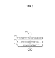
- FIG. 9 is a flowchart for explaining a process of determining the location of the vehicle when the first location information of the vehicle is not normally received and two or more infrastructure devices do not exist within the reference distance from the vehicle.
- FIG. 1 is a function block diagram of an apparatus for implementing a method for determining the location of a vehicle in accordance with an embodiment of the present invention.
- FIG. 2 is a diagram illustrating the structure of information which is received from an infrastructure device through a V2I (Vehicle-to-Infrastructure) module.
- V2I Vehicle-to-Infrastructure
- FIG. 3 is a diagram illustrating a second location of a vehicle, which is extracted on the basis of the locations of three infrastructure devices in accordance with the embodiment of the present invention.
- FIG. 4 is a diagram illustrating a second location of a vehicle, which is extracted on the basis of the locations of two infrastructures in accordance with the embodiment of the present invention.
- the apparatus for implementing the method for determining the location of a vehicle in accordance with the embodiment of the present invention may include a GNSS (Global Navigation Satellite System) receiver 100 , a V2I module 200 , a controller 300 , and a memory unit 400 .
- GNSS Global Navigation Satellite System
- the GNSS receiver 100 is a device which receives location information of a vehicle with the GNSS receiver 100 from a GNSS satellite 10 , and may include a GPS receiver (not illustrated) or GLONASS receiver (not illustrated) which receives location information.
- GNSS satellite 10 Since the GNSS satellite 10 , a ground control system (not illustrated), and the technique for acquiring location information of a vehicle with the GNSS receiver 100 through signal transmission/reception are publicly-known, the detailed descriptions thereof are omitted herein.
- the V2I module 200 may be configured to receive information containing location information of the infrastructure device 20 from the infrastructure device 20 .
- the V2I module 200 may receive the information of the infrastructure device 20 at each predetermined period.
- the method through which the V2I module 200 and the infrastructure device 20 exchange information may include all communication methods as long as the infrastructure device 20 can communicate with a vehicle.
- Examples of the communication methods may include WAVE (Wireless Access in Vehicular Environments) communication and 3G and 4G mobile communications.
- the information received from the infrastructure device 20 through the V2I module 200 may have a structure illustrated in FIG. 2 .
- the V2I module 200 may receive information containing the location information of the infrastructure device 20 from the infrastructure device 20 .
- the information may include ID (Identification) information of the infrastructure device 20 , information on the time at which the infrastructure device 20 transmits the information, and the GNSS absolute location information of the infrastructure device 20 .
- ID information may be used to distinguish the corresponding infrastructure device 20 from a plurality of infrastructure devices 20 , when plural pieces of information are received from the respective infrastructure devices 20 .
- the information received by the V2I module 200 is not limited thereto. Thus, the information may include other pieces of information.
- the controller 300 may determine the location of the vehicle based on the location information of the vehicle, received through the GNSS receiver 100 , and the location information of the infrastructure device 20 , received through the V2I module 200 .
- the location information of the vehicle received through the GNSS receiver 100 , may be referred to as first location information, and the location information of the vehicle, extracted on the basis of the location of the infrastructure device 20 , may be referred to as second location information.
- the absolute location of the infrastructure device 20 as well as the first location information of the vehicle, received through the GNSS receiver 100 may be reflected to more precisely determine the location of the vehicle.
- the controller 300 may determine the location of the vehicle in different manners depending on whether the first location information of the vehicle is normally received and whether two or more infrastructure devices 20 exist within a reference distance from the vehicle.
- the reference distance may indicate a distance between the vehicle and an infrastructure device 20 , at which information can be normally transmitted and received between the V2I module 200 and the infrastructure device 20 .
- the reference distance may differ depending on the characteristic of the V2I module 200 .
- the controller 300 may determine whether two or more infrastructure devices 20 exist within the reference distance from the vehicle.
- the controller 300 may determine the location of the vehicle according to whether the first location information of the vehicle is normally received and whether two or more infrastructure devices 20 exist. Thus, the process of determining the location of the vehicle may be divided into four cases.
- the first case is where the first location information of the vehicle is normally received and two or more infrastructure devices 20 exist within the reference distance
- the second case is where the first location information of the vehicle is normally received and two or more infrastructure devices 20 do not exist within the reference distance from the vehicle
- the third case is where the first location information of the vehicle is not normally received and two or more infrastructure devices 20 exists within the reference distance from the vehicle
- the fourth case is where the first location information of the vehicle is not normally received and two or more infrastructures 20 do not exist within the reference distance from the vehicle.
- the controller 300 may determine whether the intensity of the received first location information of the vehicle is equal to or more than reference intensity.
- the reference intensity indicates the intensity at which normal information can be considered to be contained, and may differ depending on the characteristic of the GNSS receiver 100 .
- the controller 300 may ignore the corresponding information.
- the controller 300 may determine whether a location change of the vehicle per unit time based on the received first location information of the vehicle falls within a reference change, thereby determining whether the first location information of the vehicle is normally received.
- the reference change may indicate a location change of the vehicle, which may occur while the vehicle normally travels, that is, a vehicle speed.
- the reference change may differ depending on the characteristic of the vehicle.
- the controller 300 may determine that an error exists in the first location information.
- the controller 300 may not consider the corresponding location information.
- the controller 300 may correct the first location information of the vehicle by referring to the locations of the infrastructure devices 20 , received through the V2I module 200 .
- the controller 300 may determine the number of infrastructure devices 20 within the reference distance from the vehicle based on the information received through the V2I module 200 , and extract the second location information of the vehicle based on the locations of the infrastructure devices 20 .
- the controller 300 may extract the second location information of the vehicle using a triangulation method.
- the triangulation method refers to a method which measures the plane locations of points by measuring the sides or angles of a triangle.
- the controller 300 may calculate a distance between the vehicle and an infrastructure device 20 through time information contained in the information of the infrastructure device 20 , received through the V2I module 200 , and the time at which the information is received in the vehicle.
- the distance between the vehicle and the infrastructure device 20 may be calculated through the following formula: (information transmission speed of infrastructure device 20 ⁇ (current time ⁇ information transmission time of infrastructure device 20 ).
- the controller 300 may extract the GNSS absolute location information of the infrastructure device 20 through the information received from the infrastructure device 20 .
- the controller 300 may extract the second location information corresponding to accurate location information of the vehicle among three infrastructure devices 20 .
- the controller 300 may extract plural pieces of second information of the vehicle using information of three infrastructure devices 20 , and calculate the average of the plural pieces of location information, thereby increasing the precision of the location information.
- the controller 300 may extract the second location information of the vehicle based on the traveling direction of the vehicle.
- concentric circles may be formed at the calculated distances from the two infrastructure devices 20 as illustrated in FIG. 4 , and two points A and B at which the concentric circles meet each other may become candidate points of the second location information of the vehicle.
- the controller 300 may determine which point of the two points corresponds to the initial location of the vehicle.
- the controller 300 may extract the second location information of the vehicle in such a manner.
- the controller 300 may check that the point A of the two candidate points A and B is the initial location, and thus extract the second location information of the vehicle.
- the controller 300 may calculate a location error of the vehicle based on the extracted second location information of the vehicle and the first location information of the vehicle, received through the GNSS receiver 100 , and correct the first location information of the vehicle by reflecting the location error, thereby determining the precise location of the vehicle.
- the controller 300 may correct the first location information of the vehicle by referring to the most recent location of the infrastructure device 20 .
- the controller 300 may reflect a location error of the vehicle, which is calculated and stored on the basis of the most recent location of the infrastructure device 20 .
- the first location information of the vehicle may have a constant error from the actual location of the vehicle.
- the controller 300 may correct the first location information by reflecting the previously stored location error of the vehicle, and thus determine the precise location of the vehicle.
- the controller 300 may determine the location of the vehicle by referring to the locations of the infrastructure devices 20 .
- the controller 300 may determine the location of the vehicle by reflecting only the second location information extracted on the basis of the locations of the infrastructure devices 20 .
- the controller 300 may determine the location of the vehicle based on the most recent location of the vehicle and traveling information of the vehicle.
- the controller 300 may determine the location of the vehicle based on the most recent information of the vehicle.
- the controller 300 may determine the location of the vehicle by reflecting the traveling information containing the speed and direction of the vehicle, based on the location of the vehicle which is most recently stored in the memory unit 400 .
- the controller 300 may calculate a difference between the current time and the time at which the most recent location of the vehicle is stored, and calculate the moving distance of the vehicle by multiplying the calculated difference by the speed of the vehicle. Then, the controller 300 may combine the moving distance with the direction information of the vehicle so as to determine the current location of the vehicle.
- the memory unit 400 may store the first location information of the vehicle, received through the GNSS receiver 100 , and the information of the infrastructure device 20 , received through the V2I module 200 .
- the memory unit 400 may store a location error of the vehicle, which is based on the first location information and the section location information of the vehicle and calculated through the controller 300 . Thus, when no infrastructure device 20 exists within the reference distance from the vehicle, the controller 300 may correct the first location information through the corresponding location error.
- FIG. 5 is a flowchart for explaining a process of implementing the method for determining the location of a vehicle in accordance with the embodiment of the present invention.
- FIG. 6 is a flowchart for explaining a process of determining the location of the vehicle when first location information of the vehicle is normally received and two or more infrastructure devices exist within the reference distance from the vehicle.
- FIG. 7 is a flowchart for explaining a process of determining the location of the vehicle when the first location information of the vehicle is normally received and two or more infrastructure devices do not exist within the reference distance from the vehicle.
- FIG. 8 is a flowchart for explaining a process of determining the location of the vehicle when the first location information of the vehicle is not normally received and two or more infrastructure devices exist within the reference distance from the vehicle.
- FIG. 9 is a flowchart for explaining a process of determining the location of the vehicle when the first location information of the vehicle is not normally received and two or more infrastructure devices do not exist within the reference distance from the vehicle.
- the controller 300 may determine whether first location information of the vehicle is normally received through the GNSS receiver 100 , at step S 10 .
- the controller 300 may determine that the first location information of the vehicle is normally received.
- the reference intensity indicates the intensity at which normal information can be considered to be contained, and may differ depending on the characteristic of the GNSS receiver 100 .
- the reference change may indicate a location change of the vehicle, which may occur while the vehicle normally travels, that is, a vehicle speed.
- the reference change may differ depending on the characteristic of the vehicle.
- the controller 300 may ignore information of which the intensity is less than the reference intensity.
- the controller 300 may ignore the corresponding information.
- the controller 300 may determine whether two or more infrastructure devices 20 exist within the reference distance from the vehicle, at steps S 20 and S 30 .
- the controller 300 may determine whether two or more infrastructure devices 20 exist within the reference distance from the vehicle.
- the controller 300 may determine the location of the vehicle in different manners, depending on whether the first location information of the vehicle is normally received and whether two or more infrastructure devices exist, at steps S 40 to S 70 .
- the controller 300 may correct the first location information of the vehicle by referring to the locations of the infrastructure devices 20 , received through the V2I module 200 , at step S 40 .
- the controller 300 may store the first location information of the vehicle, received through the GNSS receiver 100 , in the memory unit 400 at step S 42 , and extract the second location information of the vehicle based on the locations of the infrastructure devices 20 at step S 44 .
- the controller 300 may extract the location of the vehicle in different manners depending on the number of infrastructure devices 20 .
- the controller 300 may extract the second location information of the vehicle using a triangulation method.
- the distance between the vehicle and an infrastructure device 20 may be calculated through the following formula: (information transmission speed of infrastructure device 20 ⁇ (current time ⁇ information transmission time of infrastructure device 20 ).
- the controller 300 may extract the GNSS absolute location information of the infrastructure device 20 from the information received from the infrastructure device 20 .
- the controller 300 may extract the second location information as precise location information of the vehicle, corresponding to the locations of three infrastructure devices 20 .
- the controller 300 may extract the second location information of the vehicle based on a location error of the vehicle.
- concentric circles may be formed at the calculated distances from the two infrastructure devices 20 , and two points at which the concentric circles meet each other may become candidate points of the second location information of the vehicle.
- the controller may determine whether which points of the two points corresponds to the initial location of the vehicle.
- the controller 300 may extract the second location information of the vehicle in such a manner.
- the controller 300 may check that the point A of the two candidate points A and B is the initial position of the vehicle, and thus extract the second location information of the vehicle.
- the controller 300 may calculate a location error of the vehicle based on the extracted second information of the vehicle and the first location information of the vehicle, stored in the memory unit 400 , and store the calculation result in the memory unit 400 , at step S 46 .
- the controller 300 may correct the first location information of the vehicle by reflecting the calculated location error at step S 48 , thereby determining the precise location of the vehicle.
- the controller 300 may correct the first location information of the vehicle by referring the most recent location of the infrastructure device at step S 50 .
- the controller 300 may correct the first location information of the vehicle by referring to the location error which is calculated and stored on the basis of the most recent location of the infrastructure device 20 .
- the controller 300 may store the first location information of the vehicle, received through the GNSS receiver 100 , in the memory unit 400 at step S 52 , and correct the first location information by reflecting the location error stored in the memory unit 400 at step S 54 .
- the controller 300 may determine the location of the vehicle by referring to the locations of the infrastructure devices 20 at step S 60 .
- the controller 300 may determine the location of the vehicle by reflecting only second location information extracted on the basis of the location of the infrastructure device 20 .
- the controller 300 may extract the second location information of the vehicle based on the location of the infrastructure device 20 at step S 62 , and determine the location of the vehicle based on the extracted second location information at step S 64 .
- the controller 300 may determine the location of the vehicle based on the most recent location of the vehicle and the traveling information of the vehicle, at step S 70 .
- the controller 300 may determine the location of the vehicle based on the most recent information of the vehicle.
- the controller 300 may extract the location information of the vehicle, which is most recently stored in the memory unit 400 , at step S 72 , and extract the traveling information of the vehicle from an ECU (not illustrated) of the vehicle at step S 74 .
- the controller 300 may determine the location of the vehicle by reflecting the traveling information containing the speed and direction of the vehicle based on the location information of the vehicle, which is most recently stored in the memory unit 400 , at step S 76 .
- the controller 300 may calculate a difference between the current time and the time at which the most recent location of the vehicle is stored, and calculate the moving distance of the vehicle by multiplying the calculated difference by the speed of the vehicle. Then, the controller may combine the moving distance with the direction information of the vehicle so as to determine the current location of the vehicle.
- the fixed absolute location information of the infrastructure devices may be reflected to correct an error contained in the location information of the vehicle, received through the GNSS receiver.
- the location of the vehicle may be more precisely determined.
Landscapes
- Engineering & Computer Science (AREA)
- Radar, Positioning & Navigation (AREA)
- Remote Sensing (AREA)
- Physics & Mathematics (AREA)
- General Physics & Mathematics (AREA)
- Computer Networks & Wireless Communication (AREA)
- Automation & Control Theory (AREA)
- Navigation (AREA)
- Position Fixing By Use Of Radio Waves (AREA)
Applications Claiming Priority (2)
| Application Number | Priority Date | Filing Date | Title |
|---|---|---|---|
| KR10-2013-0133644 | 2013-11-05 | ||
| KR1020130133644A KR102263185B1 (ko) | 2013-11-05 | 2013-11-05 | 차량의 위치 결정 방법 |
Publications (2)
| Publication Number | Publication Date |
|---|---|
| US20150127250A1 US20150127250A1 (en) | 2015-05-07 |
| US9207086B2 true US9207086B2 (en) | 2015-12-08 |
Family
ID=51659510
Family Applications (1)
| Application Number | Title | Priority Date | Filing Date |
|---|---|---|---|
| US14/465,735 Active US9207086B2 (en) | 2013-11-05 | 2014-08-21 | Method for determining location of vehicle |
Country Status (4)
| Country | Link |
|---|---|
| US (1) | US9207086B2 (zh) |
| EP (1) | EP2876463B1 (zh) |
| KR (1) | KR102263185B1 (zh) |
| CN (1) | CN104614750B (zh) |
Cited By (2)
| Publication number | Priority date | Publication date | Assignee | Title |
|---|---|---|---|---|
| US20170215045A1 (en) * | 2016-01-21 | 2017-07-27 | General Motors Llc | Vehicle location services |
| US11035679B2 (en) | 2019-01-04 | 2021-06-15 | Ford Global Technologies, Llc | Localization technique |
Families Citing this family (12)
| Publication number | Priority date | Publication date | Assignee | Title |
|---|---|---|---|---|
| KR101795381B1 (ko) | 2015-11-20 | 2017-11-09 | 현대자동차 주식회사 | 차량의 위치정보 공유 시스템과 방법 및 그 방법을 기록한 컴퓨터로 판독 가능한 기록매체 |
| WO2018093396A1 (en) * | 2016-11-21 | 2018-05-24 | Ford Global Technologies, Llc | Item delivery to an unattended vehicle |
| US10094906B2 (en) * | 2016-12-22 | 2018-10-09 | GM Global Technology Operations LLC | Vehicle positioning system using V2X, sensor, and GNSS information |
| CN108033382A (zh) * | 2017-12-15 | 2018-05-15 | 武汉华志机器人产业技术研究院有限公司 | 目标车辆基于地面站进行抬升的方法、装置及系统 |
| CN108059107A (zh) * | 2017-12-15 | 2018-05-22 | 武汉华志机器人产业技术研究院有限公司 | 基于地面站抬升目标车辆的方法、装置及系统 |
| CN108810155B (zh) * | 2018-06-19 | 2020-11-03 | 中国科学院光电研究院 | 一种车联网车辆位置信息可信度评价方法及系统 |
| CN111212375B (zh) * | 2018-11-20 | 2021-08-03 | 华为技术有限公司 | 定位位置调整方法及其装置 |
| KR20200087887A (ko) * | 2018-12-28 | 2020-07-22 | 현대자동차주식회사 | 차량 및 차량 제어 방법 |
| WO2021069967A1 (en) * | 2019-10-08 | 2021-04-15 | Mobileye Vision Technologies Ltd. | Systems and methods for vehicle navigation |
| CN112509297B (zh) * | 2020-09-28 | 2022-07-26 | 国网浙江杭州市余杭区供电有限公司 | 一种输电线路防外破的智能监控方法及装置 |
| KR102617409B1 (ko) * | 2021-04-28 | 2023-12-27 | 주식회사 엘지유플러스 | 위치정보 보정방법 |
| CN115824231B (zh) * | 2023-02-22 | 2023-04-28 | 安徽阿瑞特汽车电子科技有限公司 | 一种汽车行驶智能定位管理系统 |
Citations (3)
| Publication number | Priority date | Publication date | Assignee | Title |
|---|---|---|---|---|
| KR20110080677A (ko) | 2010-01-06 | 2011-07-13 | 주식회사 금영 | Gps 수신불량에 따른 차량용 위치예측 시스템 및 이를 이용한 위치예측 방법 |
| US20120258705A1 (en) * | 2011-04-07 | 2012-10-11 | General Motors Llc | Telematics systems and methods with multiple antennas |
| US8521427B1 (en) * | 2012-11-28 | 2013-08-27 | The Boeing Company | Vehicle navigation using cellular networks |
Family Cites Families (8)
| Publication number | Priority date | Publication date | Assignee | Title |
|---|---|---|---|---|
| US5982324A (en) * | 1998-05-14 | 1999-11-09 | Nortel Networks Corporation | Combining GPS with TOA/TDOA of cellular signals to locate terminal |
| US6166685A (en) * | 1998-11-19 | 2000-12-26 | Qualcomm Incorporated | Wireless user position update using infrastructure measurements |
| JP2001174537A (ja) * | 1999-12-21 | 2001-06-29 | Hitachi Ltd | 無線端末位置測定方法およびそれを用いた端末装置 |
| US7551931B2 (en) * | 2001-01-24 | 2009-06-23 | Motorola, Inc. | Method and system for validating a mobile station location fix |
| JP2006017592A (ja) * | 2004-07-01 | 2006-01-19 | Japan Radio Co Ltd | 測位情報装置及びダウンコンバータic |
| DE102007054509A1 (de) * | 2007-11-15 | 2009-05-20 | Robert Bosch Gmbh | Verfahren zum Bestimmen einer Position eines Fahrzeugs |
| DE102011118161B3 (de) * | 2011-11-10 | 2013-03-28 | Audi Ag | Verfahren zur Positionsbestimmung |
| CN103018758A (zh) * | 2012-12-03 | 2013-04-03 | 东南大学 | 基于gps/ins/agps的移动差分基站方法 |
-
2013
- 2013-11-05 KR KR1020130133644A patent/KR102263185B1/ko active IP Right Grant
-
2014
- 2014-08-13 CN CN201410397408.7A patent/CN104614750B/zh active Active
- 2014-08-21 US US14/465,735 patent/US9207086B2/en active Active
- 2014-09-30 EP EP14187004.8A patent/EP2876463B1/en active Active
Patent Citations (3)
| Publication number | Priority date | Publication date | Assignee | Title |
|---|---|---|---|---|
| KR20110080677A (ko) | 2010-01-06 | 2011-07-13 | 주식회사 금영 | Gps 수신불량에 따른 차량용 위치예측 시스템 및 이를 이용한 위치예측 방법 |
| US20120258705A1 (en) * | 2011-04-07 | 2012-10-11 | General Motors Llc | Telematics systems and methods with multiple antennas |
| US8521427B1 (en) * | 2012-11-28 | 2013-08-27 | The Boeing Company | Vehicle navigation using cellular networks |
Cited By (3)
| Publication number | Priority date | Publication date | Assignee | Title |
|---|---|---|---|---|
| US20170215045A1 (en) * | 2016-01-21 | 2017-07-27 | General Motors Llc | Vehicle location services |
| US9913104B2 (en) * | 2016-01-21 | 2018-03-06 | General Motors Llc | Vehicle location services |
| US11035679B2 (en) | 2019-01-04 | 2021-06-15 | Ford Global Technologies, Llc | Localization technique |
Also Published As
| Publication number | Publication date |
|---|---|
| US20150127250A1 (en) | 2015-05-07 |
| EP2876463B1 (en) | 2020-04-01 |
| KR102263185B1 (ko) | 2021-06-10 |
| EP2876463A2 (en) | 2015-05-27 |
| CN104614750A (zh) | 2015-05-13 |
| EP2876463A3 (en) | 2015-09-16 |
| CN104614750B (zh) | 2017-06-23 |
| KR20150051747A (ko) | 2015-05-13 |
Similar Documents
| Publication | Publication Date | Title |
|---|---|---|
| US9207086B2 (en) | Method for determining location of vehicle | |
| US10018729B2 (en) | Selected aspects of advanced receiver autonomous integrity monitoring application to kalman filter based navigation filter | |
| US20160313450A1 (en) | Automotive gnss real time kinematic dead reckoning receiver | |
| KR101437346B1 (ko) | Gps 수신기의 위치 계산 방법, 그 방법을 구현하기 위한 프로그램이 기록된 기록매체 및 gps 수신기 | |
| US11061143B2 (en) | Global navigation satellite system, navigation terminal, navigation method and program | |
| CN107430198B (zh) | 汽车自组织实时动态漫游网络 | |
| US11428822B2 (en) | Methods and systems for location determination | |
| US10928834B2 (en) | Autonomous vehicle localization using 5G infrastructure | |
| US20160091612A1 (en) | Method for displaying a position of a vehicle | |
| WO2018052740A1 (en) | Repair of carrier-phase cycle slips using displacement data | |
| US20140203962A1 (en) | Method and System for Navigation | |
| US9720071B2 (en) | Mitigating effects of multipath during position computation | |
| AU2022204823A1 (en) | Reliability determination of location updates in multipath environments | |
| US20140180580A1 (en) | Module, device and method for positioning | |
| US20220026583A1 (en) | Enhancing Sensitivity to Reflected GNSS Signals | |
| EP2645129A1 (en) | Method and system for navigation | |
| US11567216B2 (en) | Single delta range differences using synthetic clock steering | |
| US11294072B2 (en) | Method, device and server for estimation of IFB calibration value | |
| US20240159910A1 (en) | Method and Apparatus for Localizing Road Users | |
| CN117434565A (zh) | 一种基于多接收天线的融合定位方法、装置 | |
| CN114008487A (zh) | 通过运动预测进行误差和完整性评估 |
Legal Events
| Date | Code | Title | Description |
|---|---|---|---|
| AS | Assignment |
Owner name: HYUNDAI MOBIS CO., LTD., KOREA, REPUBLIC OF Free format text: ASSIGNMENT OF ASSIGNORS INTEREST;ASSIGNOR:KIM, DONG HO;REEL/FRAME:033586/0338 Effective date: 20140721 |
|
| STCF | Information on status: patent grant |
Free format text: PATENTED CASE |
|
| FEPP | Fee payment procedure |
Free format text: PAYOR NUMBER ASSIGNED (ORIGINAL EVENT CODE: ASPN); ENTITY STATUS OF PATENT OWNER: LARGE ENTITY |
|
| MAFP | Maintenance fee payment |
Free format text: PAYMENT OF MAINTENANCE FEE, 4TH YEAR, LARGE ENTITY (ORIGINAL EVENT CODE: M1551); ENTITY STATUS OF PATENT OWNER: LARGE ENTITY Year of fee payment: 4 |
|
| MAFP | Maintenance fee payment |
Free format text: PAYMENT OF MAINTENANCE FEE, 8TH YEAR, LARGE ENTITY (ORIGINAL EVENT CODE: M1552); ENTITY STATUS OF PATENT OWNER: LARGE ENTITY Year of fee payment: 8 |