RU2616103C2 - Automated method of charting road traffic accident by using global positioning system and cameras - Google Patents
Automated method of charting road traffic accident by using global positioning system and cameras Download PDFInfo
- Publication number
- RU2616103C2 RU2616103C2 RU2015138963A RU2015138963A RU2616103C2 RU 2616103 C2 RU2616103 C2 RU 2616103C2 RU 2015138963 A RU2015138963 A RU 2015138963A RU 2015138963 A RU2015138963 A RU 2015138963A RU 2616103 C2 RU2616103 C2 RU 2616103C2
- Authority
- RU
- Russia
- Prior art keywords
- traffic accident
- traffic
- accident
- information
- incident
- Prior art date
Links
- 206010039203 Road traffic accident Diseases 0.000 title claims abstract description 105
- 238000000034 method Methods 0.000 title claims description 42
- 238000010586 diagram Methods 0.000 claims description 30
- 230000033001 locomotion Effects 0.000 claims description 15
- 238000007689 inspection Methods 0.000 claims description 11
- 230000007613 environmental effect Effects 0.000 claims description 7
- 238000005259 measurement Methods 0.000 claims description 7
- 238000004590 computer program Methods 0.000 claims description 6
- 238000004364 calculation method Methods 0.000 claims description 4
- 239000013589 supplement Substances 0.000 claims description 4
- 238000009941 weaving Methods 0.000 claims 1
- 239000000126 substance Substances 0.000 abstract 1
- 238000005516 engineering process Methods 0.000 description 8
- 238000004458 analytical method Methods 0.000 description 5
- 230000000903 blocking effect Effects 0.000 description 4
- 238000011835 investigation Methods 0.000 description 3
- 238000012545 processing Methods 0.000 description 3
- 230000033764 rhythmic process Effects 0.000 description 3
- 238000012546 transfer Methods 0.000 description 3
- 238000013459 approach Methods 0.000 description 2
- 238000013507 mapping Methods 0.000 description 2
- 230000005540 biological transmission Effects 0.000 description 1
- 230000015572 biosynthetic process Effects 0.000 description 1
- 238000013461 design Methods 0.000 description 1
- 238000011161 development Methods 0.000 description 1
- 238000009434 installation Methods 0.000 description 1
- 239000000463 material Substances 0.000 description 1
- 238000012806 monitoring device Methods 0.000 description 1
- 238000012544 monitoring process Methods 0.000 description 1
- 230000001105 regulatory effect Effects 0.000 description 1
- 238000011160 research Methods 0.000 description 1
Images
Classifications
-
- B—PERFORMING OPERATIONS; TRANSPORTING
- B62—LAND VEHICLES FOR TRAVELLING OTHERWISE THAN ON RAILS
- B62D—MOTOR VEHICLES; TRAILERS
- B62D41/00—Fittings for identifying vehicles in case of collision; Fittings for marking or recording collision areas
Landscapes
- Engineering & Computer Science (AREA)
- Chemical & Material Sciences (AREA)
- Combustion & Propulsion (AREA)
- Transportation (AREA)
- Mechanical Engineering (AREA)
- Traffic Control Systems (AREA)
Abstract
Description
Изобретение относится к системам регулирования движения дорожного транспорта, а именно к области исследования дорожно-транспортных происшествий, и преимущественно может быть использовано для автоматизированного формирования в электронном виде и выдачи на бумажном носителе схемы дорожно-транспортного происшествия для последующего использования экспертами, работниками государственной инспекции безопасности дорожного движения и другими заинтересованными лицами.The invention relates to systems for regulating the movement of road transport, namely, to the field of investigation of road traffic accidents, and can mainly be used for the automated formation in electronic form and the issuance on paper of a traffic accident diagram for subsequent use by experts, employees of the state traffic safety inspectorate movements and other interested parties.
Заявляемое изобретение относится к приоритетным направлениям развития науки и технологий «Технологии обработки, хранения, передачи и защиты информации» и «Технологий снижения риска и уменьшения последствий природных и техногенных катастроф» [Алфавитно-предметный указатель к Международной патентной классификации по приоритетным направлениям развития науки и технологий / Ю.Г. Смирнов, Е.В. Скиданова, С.А. Краснов. - М.: ПАТЕНТ, 2008. - с. 49, 65].The claimed invention relates to priority areas of development of science and technology "Technologies for processing, storage, transmission and protection of information" and "Technologies to reduce risk and reduce the consequences of natural and technological disasters" [Alphabetical subject index to the International Patent Classification in priority areas of science and technology / Yu.G. Smirnov, E.V. Skidanova, S.A. Krasnov. - M.: PATENT, 2008 .-- p. 49, 65].
Осмотр места совершения дорожно-транспортного происшествия создает неудобства для транспортного потока. Часто это вызывает транспортные «пробки», блокирует отдельные дорожные направления, развязки. В определенной степени это сказывается на общем ритме движения транспорта, безопасности и экономике. Необходимо решить задачу оперативного (быстрого) осмотра и фиксации места дорожно-транспортного происшествия с целью освобождения проезжей части дороги. По мнению специалистов, время для подобных действий сотрудниками инспекции безопасности дорожного движения должно быть сокращено до 10-15 минут.Inspection of the scene of a traffic accident creates inconvenience to traffic. Often this causes traffic jams, blocks individual road directions, junctions. To a certain extent, this affects the general rhythm of traffic, security and the economy. It is necessary to solve the problem of operational (quick) inspection and fixing the place of a traffic accident in order to free the carriageway. According to experts, the time for such actions by the traffic safety inspectorate should be reduced to 10-15 minutes.
Технология осмотра места дорожно-транспортного происшествия с определенной степенью условности можно разделить на два этапа. Первый, это фиксация объектов, транспортных средств и следов их движения на проезжей части дороги в процессе дорожно-транспортного происшествия. Второй этап, это детальный осмотр отдельных объектов, включающих транспортные средства, потерпевших и т.д. Второй этап не связан с блокированием транспортного потока - осмотр объектов может производиться после эвакуации аварийных транспортных средств с проезжей части дороги.The technology for examining the scene of a traffic accident with a certain degree of conditionality can be divided into two stages. The first is the fixation of objects, vehicles and traces of their movement on the carriageway in the process of a traffic accident. The second stage is a detailed inspection of individual objects, including vehicles, victims, etc. The second stage is not connected with blocking the traffic flow - objects can be inspected after the evacuation of emergency vehicles from the carriageway.
Как показывает анализ практики осмотра места дорожно-транспортного происшествия, основное время первого этапа расходуется на проведение измерений на проезжей части дороги. В зависимости от сложности дорожно-транспортного происшествия и количества участвующих в нем транспортных средств и пешеходов среднее количество измерений на проезжей части составляет от 12 до 26, на что уходит в среднем 25-40 минут. Следовательно, сокращение времени, затрачиваемое для получения схемы дорожно-транспортных происшествий, а также повышение точности определения факторов дорожно-транспортного происшествия является актуальной задачей в условиях возрастающего объема перевозок.As an analysis of the practice of inspecting the scene of a traffic accident shows, the main time of the first stage is spent on measurements on the carriageway. Depending on the complexity of the traffic accident and the number of vehicles and pedestrians involved in it, the average number of measurements on the roadway is from 12 to 26, which takes an average of 25-40 minutes. Therefore, reducing the time taken to obtain a scheme of traffic accidents, as well as improving the accuracy of determining the factors of a traffic accident is an urgent task in the face of an increasing volume of traffic.
Из уровня техники широко известны способы получения схем дорожно-транспортных происшествий на основе сбора и анализа данных о дорожно-транспортном происшествии, которые в общей для них части включают определение параметров движения транспортного средства с помощью установленных на нем датчиков, запоминание с помощью установленного на транспортном средстве запоминающего устройства параметров его движения в момент дорожно-транспортного происшествия, определяемый с помощью установленного на транспортном средстве датчика дорожно-транспортного происшествия, а также на интервале времени, непосредственно предшествующем дорожно-транспортному происшествию, восстановление информации о траектории и параметрах движения транспортного средства и анализ этой информации с целью определения обстоятельств дорожно-транспортного происшествия [US 4188618, 1980; GB 2055469, 1980; DE 4132981, 1992; GB 2268608, 1994; RU 2102263, 1998; US 2002/0103622, 2002; RU 2193233, 2002; RU 2193989, 2002; RU 2221277, 2004, RU 2222830, 2004, RU 2232097, 2004].The prior art widely known methods for obtaining schemes of traffic accidents based on the collection and analysis of data on a traffic accident, which in their common part include determining the vehicle’s motion parameters using sensors installed on it, memorizing using a vehicle’s installed the storage device of the parameters of its movement at the time of a traffic accident, determined using a traffic sensor installed on the vehicle accident, as well as on the time interval immediately preceding the traffic accident, the restoration of information about the trajectory and parameters of the vehicle and the analysis of this information in order to determine the circumstances of the accident [US 4188618, 1980; GB 2055469, 1980; DE 4132981, 1992; GB 2268608, 1994; RU 2102263, 1998; US 2002/0103622, 2002; RU 2193233, 2002; RU 2193989, 2002; RU 2221277, 2004, RU 2222830, 2004, RU 2232097, 2004].
Известен, например, способ получения схемы дорожно-транспортного происшествия путем сбора и анализа данных о дорожно-транспортном происшествии [патент RU №2222830, G07C 5/08, B60R 16/02, опубликовано 27.01.2004].Known, for example, is a method of obtaining a traffic accident scheme by collecting and analyzing data on a traffic accident [RU patent No. 2222830, G07C 5/08, B60R 16/02, published January 27, 2004].
Признаками аналога, совпадающими с существенными признаками заявляемого способа, являются: сбор передача информации о параметрах движения транспортных средств, о действиях водителя при дорожно-транспортном происшествии.Signs of an analogue that coincide with the essential features of the proposed method are: collection of information on the parameters of the movement of vehicles, on the actions of the driver in a traffic accident.
Недостатком способа является то, что он не дает возможности составления полной схемы дорожно-транспортного происшествия - расположения транспортных средств и пешеходов - участников дорожно-транспортного происшествия, размеров и расстояний объектов на месте дорожно-транспортного происшествия.The disadvantage of this method is that it does not allow the preparation of a complete diagram of a traffic accident - the location of vehicles and pedestrians - participants in a traffic accident, the size and distance of objects at the scene of a traffic accident.
Из уровня техники известны способы составления схем дорожно-транспортных происшествий путем регистрации окружающей обстановки при дорожно-транспортном происшествии посредством размещения на транспортном средстве одной или нескольких видеокамер, формирования сигнала изображения окружающей обстановки, в том числе и изображения технических средств организации движения с помощью видеокамер, запоминания текущего сигнала изображения окружающей обстановки в момент дорожно-транспортного происшествия, определяемый по сигналу с установленного на транспортном средстве датчика дорожно-транспортного происшествия, восстановления изображения и его анализа с целью определения обстоятельств дорожно-транспортного происшествия.The prior art methods for compiling traffic accident patterns by recording the environment during a traffic accident by placing one or more video cameras on a vehicle, generating an image signal of the environment, including images of traffic management equipment using video cameras, storing the current signal image of the environment at the time of the traffic accident, determined by the signal from the installation ennogo vehicle sensor traffic accident, image reconstruction and analysis in order to determine the circumstances of the traffic accident.
Так известен способ составления схемы дорожно-транспортного происшествия путем регистрации транспортного происшествия посредством размещения на транспортном средстве одной или нескольких телекамер наблюдения [RU 2203507, G07C 5/08, G08G 1/04, опубликовано 27.04.2003].So there is a known method of compiling a traffic accident scheme by registering a traffic accident by placing one or more surveillance cameras on a vehicle [RU 2203507, G07C 5/08, G08G 1/04, published 04/27/2003].
Признаками аналога, совпадающими с существенными признаками заявляемого способа, являются: сбор информации об окружающей обстановке, в том числе и о текущем состоянии технических средств организации движения при дорожно-транспортном происшествии.Signs of an analogue that coincide with the essential features of the proposed method are: the collection of information about the environment, including the current state of the technical means of organizing traffic in a traffic accident.
Недостатком указанного способа является то, что он не дает возможности составления полной схемы дорожно-транспортного происшествия - расположения транспортных средств и пешеходов - участников дорожно-транспортного происшествия, размеров и расстояний объектов на месте происшествия.The disadvantage of this method is that it does not allow the preparation of a complete diagram of a traffic accident - the location of vehicles and pedestrians - participants in a traffic accident, the size and distance of objects at the scene.
Известен способ составления схемы дорожно-транспортного происшествия путем фиксации параметров движения и состояния транспортного средства, а также фиксации окружающей обстановки [RU 2219584, G07C 5/0, опубликовано 20.12.2003].A known method of charting a traffic accident by fixing the parameters of the movement and condition of the vehicle, as well as fixing the environment [RU 2219584, G07C 5/0, published 20.12.2003].
Признаками аналога, совпадающими с существенными признаками заявляемого способа, также являются: сбор информации об окружающей обстановке, в том числе и о текущем состоянии технических средств организации движения при дорожно-транспортном происшествии.Signs of an analogue that coincide with the essential features of the proposed method are also: the collection of information about the environment, including the current state of the technical means of organizing traffic in a traffic accident.
Недостатком указанного аналога также является то, что он не дает возможности составления полной схемы дорожно-транспортного происшествия - расположения транспортных средств и пешеходов - участников дорожно-транспортного происшествия, размеров и расстояний объектов на месте происшествия.The disadvantage of this analogue is also that it does not make it possible to draw up a complete diagram of a traffic accident - the location of vehicles and pedestrians - participants in a traffic accident, the size and distance of objects at the scene of the accident.
Известен способ составления схемы дорожно-транспортного происшествия с использованием системы удаленного доступа по анализу и оценке дорожно-транспортного происшествия [заявка на изобретение RU 2007130806, B60R 1/00, опубликована 20.02.2009], в котором транспортные средства оснащают устройствами мониторинга, позволяющими вести в режиме реального времени мониторинг состояния транспортного средства с видеосъемкой и с фиксацией момента дорожно-транспортного происшествия с помощью датчиков, и передавать удаленно информацию о событиях за заданный интервал времени до и после момента дорожно-транспортного происшествия и пространственные координаты транспортного средства - участника дорожно-транспортного происшествия.A known method of compiling a traffic accident scheme using a remote access system for the analysis and assessment of a traffic accident [patent application RU 2007130806,
Признаками аналога, совпадающими с существенными признаками заявляемого способа, являются: - сбор и сохранение в электронном виде с возможностью выдачи на бумажный носитель информации об окружающей обстановке, в том числе и о текущем состоянии технических средств организации движения при дорожно-транспортном происшествии, о пространственных координатах транспортного средства - участника дорожно-транспортного происшествия.Signs of an analogue that coincide with the essential features of the proposed method are: - collection and storage in electronic form with the possibility of issuing on a paper medium information about the environment, including the current state of the technical means of organizing traffic during a traffic accident, and spatial coordinates a vehicle - a participant in a traffic accident.
Недостатком указанного способа является то, что он не дает возможности составления полной схемы дорожно-транспортного происшествия - расположения других транспортных средств и пешеходов - участников дорожно-транспортного происшествия, размеров и расстояний объектов на месте дорожно-транспортного происшествия. Кроме того, для реализации указанного способа потребуются значительные материальные затраты.The disadvantage of this method is that it does not allow the preparation of a complete diagram of a traffic accident - the location of other vehicles and pedestrians - participants in a traffic accident, the size and distance of objects at the scene of a traffic accident. In addition, the implementation of this method will require significant material costs.
Известен способ автоматизированного составления схемы дорожно-транспортного происшествия с использованием системы автоматизированного составления схемы дорожно-транспортного происшествия - «AUTO-GRAF 1.1», которая представляет собой компьютерную программу - графический редактор, позволяющий строить масштабные схемы дорожно-транспортных происшествий и тем самым моделировать обстановку места происшествия. Программа содержит полную базу транспортных средств, дорожных знаков и разметки, элементов вещной обстановки на месте дорожно-транспортного происшествия (дома, светофоры, деревья, пешеходы и т.д.) [ресурс интернета http://www.autor%c3%ade.ru/aticles/1024/1. Программа создана в ГУ СЗРЦСЭ в 1999. При создании графического редактора "AUTO-GRAF 1.1" было обеспечено его соответствие общепринятым стандартам на предназначенные для работы с графическими объектами программные продукты, и требованиям, вытекающим из экспертной практики. Такой подход позволил снизить трудоемкость построения схем с помощью программы, повысил их точность. Программа располагает большой базой изображений транспортных средств - более 170 автомобилей. При отсутствии в базе автомобиля какой-либо модели она может быть введена в базу экспертом самостоятельно при помощи имеющегося в программе шаблона автомобиля. Кроме этого, в программу введен такой инструмент, как шаблоны перекрестков. С их помощью эксперт может создать на экране компьютера перекресток или участок дороги необходимой конфигурации с требуемой шириной проезжих частей. Программа проста в использовании и легка в освоении и повышает наглядность и достоверность экспертных исследований.A known method of automated mapping of a traffic accident using the automated circuit of a traffic accident - "AUTO-GRAF 1.1", which is a computer program - a graphical editor that allows you to build large-scale diagrams of traffic accidents and thereby simulate the situation of the place incidents. The program contains a complete database of vehicles, road signs and markings, elements of the traffic situation at the scene of a traffic accident (houses, traffic lights, trees, pedestrians, etc.) [Internet resource http: //www.autor%c3%ade. com / aticles / 1024/1. The program was created at the SZRTSSE in 1999. When creating the graphic editor "AUTO-GRAF 1.1", it was ensured that it complies with generally accepted standards for software products designed for working with graphic objects, and with requirements arising from expert practice. This approach allowed to reduce the complexity of constructing schemes using the program, and increased their accuracy. The program has a large database of images of vehicles - more than 170 cars. If there is no model in the car database, it can be entered into the database by an expert independently using the car template available in the program. In addition, a tool such as intersection patterns has been introduced into the program. With their help, an expert can create an intersection or a section of the road of the necessary configuration on the computer screen with the required width of carriageways. The program is easy to use and easy to learn and increases the visibility and reliability of expert research.
Признаками аналога, совпадающими с существенными признаками заявляемого способа, являются: - сбор и нанесение на схему дорожно-транспортного происшествия информации о транспортных средствах, пешеходах, об окружающей обстановке, в том числе и о текущем состоянии технических средств организации движения.Signs of an analogue that coincide with the essential features of the proposed method are: - collection and application of information about vehicles, pedestrians, the environment, including the current state of traffic management equipment, to the traffic accident diagram.
Недостатком указанного способа является то, что для составления полной схемы дорожно-транспортного происшествия необходимо провести существенный объем ручных измерений - расположения транспортных средств и пешеходов - участников дорожно-транспортного происшествия, размеров и расстояний объектов на месте дорожно-транспортного происшествия, и вручную нанести информацию о размерах и расстояниях на электронную схему дорожно-транспортного происшествия, что увеличивает время составления схемы.The disadvantage of this method is that to draw up a complete diagram of a traffic accident it is necessary to take a significant amount of manual measurements - the location of vehicles and pedestrians - participants in a traffic accident, the size and distance of objects at the scene of a traffic accident, and manually enter information about the size and distance of the electronic circuit of a traffic accident, which increases the time for compiling the circuit.
Известен способ составления схемы дорожно-транспортного происшествия на основе определения факторов дорожно-транспортного происшествия [патент RU 2196697, B62D 41/00, опубликовано 20.01.2003], который заключается в составлении схемы дорожно-транспортного происшествия в масштабе с изображением моделей транспортных средств, размеров и расстояний на основе предварительного изучения дорожной обстановки на момент дорожно-транспортного происшествия, характеристик транспортных средств, следов аварии. Указанный способ позволяет повысить точность определения факторов дорожно-транспортного происшествия на основе объективных факторов, однако, составление схемы дорожно-транспортного происшествия - расположение изображений транспортных средств и пешеходов на схеме, измерения размеров и расстояний на местности, оформление схемы на бумажном носителе требует больших затрат времени и высокой аккуратности при рисовании и отображении.A known method of charting a traffic accident based on the determination of the factors of a traffic accident [patent RU 2196697, B62D 41/00, published 01/20/2003], which consists in drawing up a diagram of a traffic accident in scale with the image of models of vehicles, sizes and distances based on a preliminary study of the traffic situation at the time of the traffic accident, vehicle characteristics, traces of the accident. The specified method allows to increase the accuracy of determining the factors of a traffic accident based on objective factors, however, drawing up a diagram of a traffic accident - placing images of vehicles and pedestrians on a diagram, measuring dimensions and distances on the ground, drawing up a diagram on paper is time-consuming and high accuracy when drawing and displaying.
Признаки аналога, совпадающие с существенными признаками заявляемого способа, следующие: составляют на бумажном носителе топографическое изображение места дорожно-транспортного происшествия и окружающей его обстановки со всеми имеющимися объектами, предметами и следами, обнаруженными в процессе следственного осмотра, и результатов ряда других действий, такими как:Signs of an analogue that coincide with the essential features of the proposed method are as follows: make up on paper a topographic image of the scene of the traffic accident and its surroundings with all available objects, objects and tracks found during the investigation, and the results of several other actions, such as :
- транспортные средства - участники происшествия, с их расположением на схеме,- vehicles - participants of the incident, with their location on the diagram,
- все имеющиеся следы происшествия, их состояние, характер, расположение, размеры,- all available traces of the incident, their condition, nature, location, size,
- особенности окружающей обстановки - стоявшие в момент дорожно-транспортного происшествия транспортные средства, разнообразные предметы, а также дома, арки, ворота, заборы, рекламные тумбы, газоны, клумбы, скверы; всевозможные постройки и прочие препятствия, ограничивающие обзорность; бордюрные камни, люки колодцев подземных коммуникаций и др., расположенные поблизости учреждения, предприятия, магазины, лотки, киоски, таксофонные будки, тропинки, мостки и др., по направлению к которым или от которых мог двигаться кто-либо из участников происшествия или очевидец,- environmental features - standing at the time of the traffic accident vehicles, various items, as well as houses, arches, gates, fences, advertising stands, lawns, flower beds, squares; all kinds of buildings and other obstacles that limit visibility; curbs, manholes of underground utilities wells, etc., located nearby institutions, enterprises, shops, trays, kiosks, payphone booths, paths, walkways, etc., in the direction to which or from which one of the participants of the incident or an eyewitness could move ,
- сведения о технических средствах организации дорожного движения - все имеющиеся на месте происшествии светофоры, дорожные знаки, линии и надписи дорожной разметки в полном соответствии с их действительным расположением на осматриваемом участке,- information about the technical means of organizing traffic - all the traffic lights available at the scene of the accident, road signs, lines and inscriptions of the road markings in full accordance with their actual location on the inspected area,
- отдельные сведения из показаний участников или очевидцев происшествия или установленные объективно по имеющимся признакам (следам) в ходе осмотра места происшествия или непосредственно по его окончании,- individual information from the testimonies of the participants or eyewitnesses of the incident or established objectively by the available signs (traces) during the inspection of the scene of the incident or immediately after it,
- прочие сведения: направление движения участников происшествия; место (точка), с которого производилось фотографирование; воспроизведенный экспериментальным путем или по показаниям водителя путь движения транспортного средства при совершении им какого-либо поворота (так называемая дуга поворота); сведения о продольном и поперечном профиле дороги (закругление, уклон, подъем, вираж), о размещении светильников (в темное время суток) и прочее - по мере необходимости,- other information: the direction of movement of the participants in the incident; place (point) from which photographing was made; the vehicle’s path of movement of the vehicle reproduced experimentally or according to the testimony of the driver when he makes any turn (the so-called turn arc); information on the longitudinal and transverse profile of the road (rounding, slope, rise, turn), on the placement of lamps (in the dark), and so on, as necessary,
выполняют на местности и наносят на схему измерения в принятой системе отсчета и оформляют схему происшествия на бумажном носителе подписями всех водителей и пешеходов - участников происшествия и составителя схемы.perform on the ground and put on the measurement scheme in the adopted reference system and draw up the incident scheme on paper with the signatures of all the drivers and pedestrians - participants of the accident and the drafter.
Недостатком способа по патенту RU 2196697 является необходимость ручного рисования на бумажном носителе плана участка местности, применения ручных измерений и ручной привязки объектов на топографическом плане участка местности места дорожно-транспортного происшествия.The disadvantage of the method according to the patent RU 2196697 is the need for manual drawing on paper of a plan of the terrain, the use of manual measurements and manual binding of objects on the topographic plan of the terrain to the scene of a traffic accident.
Указанный недостаток может приводить к увеличению времени осмотра и фиксации места совершения дорожно-транспортного происшествия, созданию неудобств для транспортного потока, блокированию отдельных дорожных направлений, развязок, что отразится на общем ритме движения транспорта, безопасности и экономике. Кроме того, в схеме дорожно-транспортного происшествия могут быть неточно отображены объекты схемы, размеры и расстояния.This drawback can lead to an increase in the time of inspection and fixing the place of the accident, the creation of inconveniences for traffic, the blocking of certain road directions, interchanges, which will affect the general rhythm of traffic, security and the economy. In addition, the objects of the scheme, sizes and distances may not be accurately displayed in the traffic accident diagram.
Известен способ восстановления обстановки на месте дорожно-транспортного происшествия с использованием фотограмметрии [Бондаренко А.А. Правовые и технико-криминалистические особенности применения фотограмметрических методов для фиксации места обстановки дорожно-транспортного происшествия, автореферат диссертации кандидата юридических наук: 12.00.09, Волгоград, 2008]. Фотограмметрическая обработка заключается в нанесении на изображения места происшествия, выведенные на экран компьютера, отметок, обозначающих ситуационные точки, которые однозначно определяют положение того или иного объекта. Координаты ситуационных точек, а по сути, расположение объектов в пространстве рассчитываются автоматически. Расстояния между точками также автоматически наносятся на план места происшествия. Применение методов тригонометрии, цифровой обработки изображений с помощью компьютерных технологий позволяет по измерительным фотоснимкам и даже обычным (если в кадре есть объект с известными стандартными линейными размерами) восстановить обстановку на месте происшествия, связанного с ДТП; тем самым повышая результативность осмотров мест происшествий, при сокращении времени его проведения.A known method of restoring the situation at the scene of a traffic accident using photogrammetry [Bondarenko A.A. Legal and technical and forensic features of the use of photogrammetric methods for fixing the location of the situation of a traffic accident, an abstract of the dissertation of the candidate of legal sciences: 12.00.09, Volgograd, 2008]. Photogrammetric processing consists in applying marks on the computer screen to marks indicating situational points that uniquely determine the position of an object. The coordinates of the situational points, and in fact, the location of objects in space are calculated automatically. Distances between points are also automatically plotted on the scene of the incident. The application of trigonometry methods, digital image processing using computer technology makes it possible to restore the situation at the scene of an accident-related accident using measuring photographs and even ordinary ones (if the frame contains an object with known standard linear dimensions); thereby increasing the effectiveness of inspections of accident sites, while reducing the time of its conduct.
Недостатком способа является необходимость проведения измерений некоторых объектов, по сопоставлению с которыми устанавливаются остальные расстояния и размеры на мете происшествия.The disadvantage of this method is the need to measure some objects, in comparison with which the remaining distances and sizes are set on the incident meta.
Указанный недостаток может приводить к увеличению времени осмотра и фиксации места совершения дорожно-транспортного происшествия, созданию неудобств для транспортного потока, блокированию отдельных дорожных направлений, развязок, что отразится на общем ритме движения транспорта, безопасности и экономике.This drawback can lead to an increase in the time of inspection and fixing the place of the accident, the creation of inconveniences for traffic, the blocking of certain road directions, interchanges, which will affect the general rhythm of traffic, security and the economy.
Известен способ автоматизированного составления схемы дорожно-транспортного происшествия [патент RU №2507101]Ё принятый за прототип, в котором предварительно составляют компьютерную базу данных топографических планов участков местности в принятом масштабе, выбирают на мониторе компьютера план участка местности, на котором развивалось дорожно-транспортное происшествие, размещают на выбранном участке с помощью специализированного графического редактора изображения транспортных средств, пешеходов и других объектов, изображения всех имеющихся следов происшествия, производят с помощью устройства глобального позиционирования привязку к системе отсчета изображений всех транспортных средств, пешеходов - участников дорожно-транспортного происшествия, и изображений всех значимых для происшествия объектов, по которой выполняют расчеты по компьютерной программе, которая определяет размеры и расстояния на схеме в выбранной системе отсчета, отмечают их состояние, характер, указывают текстом или графическими значками особенности окружающей обстановки, сведения о технических средствах организации дорожного движения, отдельные сведения из показаний участников или очевидцев происшествия или установленные объективно по имеющимся признакам, прочие сведения, формируют схему происшествия в электронном виде, производят распечатку схемы дорожно-транспортного происшествия на принтере в принятом размере, например 300×400 мм, и оформляют схему происшествия на бумажном носителе подписями всех участников происшествия и составителя схемы.A known method of automated mapping of a traffic accident [patent RU No. 2507101] is taken as a prototype in which a computer database of topographic plans of terrain plots on an accepted scale is preliminarily prepared, a plan of the terrain plot on which the traffic accident developed on a computer monitor placed on a selected site using a specialized graphic editor of the image of vehicles, pedestrians and other objects, images of all of them Using the global positioning device, the system tracks the images of all vehicles, pedestrians participating in a traffic accident, and images of all objects significant for the accident, and calculates them using a computer program that determines the sizes and distances on the diagram in the selected reference system, note their condition, character, indicate with text or graphic icons the features of the environment, information about technical x means of organizing traffic, some information from the testimonies of the participants or eyewitnesses to the incident or established objectively based on available signs, other information, form an accident diagram in electronic form, print out a traffic accident diagram on a printer in an accepted size, for example 300 × 400 mm, and draw up the incident diagram on paper with the signatures of all the participants in the incident and the originator of the diagram.
Признаками прототипа, совпадающими с существенными признаками заявляемого способа, являются:The signs of the prototype, coinciding with the essential features of the proposed method are:
составляют на бумажном носителе топографический план участка местности места дорожно-транспортного происшествия и окружающей его обстановки со всеми имеющимися объектами, предметами и следами, обнаруженными в процессе следственного осмотра, и результатов ряда других действий, такими как:draw up a topographic plan on a hard copy of the site of the terrain of the place of the traffic accident and its environment with all available objects, objects and tracks discovered during the investigation, and the results of a number of other actions, such as:
- транспортные средства - участники происшествия, с их расположением на схеме,- vehicles - participants of the incident, with their location on the diagram,
- все имеющиеся следы происшествия, их состояние, характер, расположение, размеры,- all available traces of the incident, their condition, nature, location, size,
- особенности окружающей обстановки - стоявшие в момент дорожно-транспортного происшествия транспортные средства, разнообразные предметы, а также дома, арки, ворота, заборы, рекламные тумбы, газоны, клумбы, скверы; всевозможные постройки и прочие препятствия, ограничивающие обзорность; бордюрные камни, люки колодцев подземных коммуникаций и др., расположенные поблизости учреждения, предприятия, магазины, лотки, киоски, таксофонные будки, тропинки, мостки и др., по направлению к которым или от которых мог двигаться кто-либо из участников происшествия или очевидец,- environmental features - standing at the time of the traffic accident vehicles, various items, as well as houses, arches, gates, fences, advertising stands, lawns, flower beds, squares; all kinds of buildings and other obstacles that limit visibility; curbs, manholes of underground utilities wells, etc., located nearby institutions, enterprises, shops, trays, kiosks, payphone booths, paths, walkways, etc., in the direction to which or from which one of the participants of the incident or an eyewitness could move ,
- сведения о технических средствах организации дорожного движения - все имеющиеся на месте происшествии светофоры, дорожные знаки, линии и надписи дорожной разметки в полном соответствии с их действительным расположением на осматриваемом участке,- information about the technical means of organizing traffic - all the traffic lights available at the scene of the accident, road signs, lines and inscriptions of the road markings in full accordance with their actual location on the inspected area,
- отдельные сведения из показаний участников или очевидцев происшествия или установленные объективно по имеющимся признакам (следам) в ходе осмотра места происшествия или непосредственно по его окончании,- individual information from the testimonies of the participants or eyewitnesses of the incident or established objectively by the available signs (traces) during the inspection of the scene of the incident or immediately after it,
- прочие сведения: направление движения участников происшествия; место (точка), с которого производилось фотографирование; воспроизведенный экспериментальным путем или по показаниям водителя путь движения транспортного средства при совершении им какого-либо поворота (так называемая дуга поворота); сведения о продольном и поперечном профиле дороги (закругление, уклон, подъем, вираж), о размещении светильников (в темное время суток) и прочее - по мере необходимости,- other information: the direction of movement of the participants in the incident; place (point) from which photographing was made; the vehicle’s path of movement of the vehicle reproduced experimentally or according to the testimony of the driver when he makes any turn (the so-called turn arc); information on the longitudinal and transverse profile of the road (rounding, slope, rise, turn), on the placement of lamps (in the dark), and so on, as necessary,
выполняют на местности и наносят на схему измерения в принятой системе отсчета и оформляют схему происшествия на бумажном носителе подписями всех водителей и пешеходов - участников происшествия и составителя схемы.perform on the ground and put on the measurement scheme in the adopted reference system and draw up the incident scheme on paper with the signatures of all the drivers and pedestrians - participants of the accident and the drafter.
Признаки прототипа, отличающиеся от существенных признаков заявляемого способа, следующие:Signs of the prototype, different from the essential features of the proposed method, the following:
1. Топографическое изображение плана участка местности формируют на основании совмещения данных от устройств глобального позиционирования и устройства фотографирования, для чего размещают четыре или более устройств глобального позиционирования, имеющие видимые сверху метки, в существенных точках участка местности, передают полученные координаты с устройств позиционирования в компьютер, фотографируют участок местности сверху с помощью фотокамеры, расположенной на летательном аппарате вертикального взлета, например на радиоуправляемом квадрокоптере, передают фотографию в компьютер,1. A topographic image of the plan of the terrain plot is formed on the basis of combining data from global positioning devices and photographing devices, for which four or more global positioning devices with visible marks on top are placed at significant points of the terrain, the received coordinates are transmitted from positioning devices to a computer, they photograph a section of terrain from above using a camera located on an aircraft of vertical take-off, for example, on a radio control removable quadrocopter, transfer the photo to the computer,
2. В компьютерной программе совмещают по меткам на фотографии положение устройств позиционирования с их координатами, выполняют расчеты, в которых определяют размеры, расстояния и высоты на плане участка местности в заданной системе отсчета,2. In a computer program, the position of the positioning devices with their coordinates is combined according to the marks in the photograph, calculations are performed that determine the sizes, distances and heights on the plan of the terrain in a given reference system,
3. Дополняют к изображениям на фотографии состояние, характер участников дорожно-транспортного происшествия: транспортных средств, пешеходов, других объектов и всех имеющихся следов происшествия,3. Supplement to the images in the photograph the state and nature of the participants in the traffic accident: vehicles, pedestrians, other objects and all available traces of the accident,
4. Дополняют к изображению на фотографии на плане участка местности текстом или графическими значками особенности окружающей обстановки, сведения о технических средствах организации дорожного движения, отдельные сведения из показаний участников или очевидцев происшествия или установленные объективно по имеющимся признакам прочие сведения.4. Supplement to the image in the photograph on the plan of the terrain with text or graphic icons environmental features, information about the technical means of organizing traffic, some information from the testimonies of the participants or eyewitnesses of the accident, or other information established objectively based on available signs.
Отличия от прототипа доказывают новизну технического решения, охарактеризованного в формуле изобретения.Differences from the prototype prove the novelty of the technical solution described in the claims.
Изобретение направлено на решение задачи по созданию технологии, позволяющей повысить эффективность дорожно-транспортного движения.The invention is aimed at solving the problem of creating technology to improve the efficiency of road traffic.
Технический результат заключается в повышении точности и оперативности определения факторов дорожно-транспортного происшествия на основе объективных параметров.The technical result consists in increasing the accuracy and efficiency of determining the factors of a traffic accident based on objective parameters.
Технический результат достигается тем, что размещают четыре или более устройств глобального позиционирования, имеющие видимые сверху метки, в существенных точках участка местности, передают полученные координаты с устройств позиционирования в компьютер, фотографируют участок местности сверху с помощью фотокамеры, расположенной на летательном аппарате вертикального взлета, например на радиоуправляемом квадрокоптере, передают фотографию в компьютер, где совмещают по меткам на фотографии положение устройств позиционирования с их координатами, выполняют расчеты по компьютерной программе, в которой определяют размеры, расстояния и высоты на плане участка местности в заданной системе отсчета, дополняют к изображению на фотографии состояние, характер участников дорожно-транспортного происшествия: транспортных средств, пешеходов, других объектов и всех имеющихся следов происшествия, дополняют к изображению на фотографии на плане участка местности текстом или графическими значками особенности окружающей обстановки, сведения о технических средствах организации дорожного движения, отдельные сведения из показаний участников или очевидцев происшествия или установленные объективно по имеющимся признакам прочие сведения, формируют схему дорожно-транспортного происшествия в электронном виде и/или фотографию участка местности с нанесенной информацией о дорожно-транспортном происшествии, производят распечатку на бумажный носитель схемы и/или фотографии дорожно-транспортного происшествия на принтере в принятом размере, например 300×400 мм.The technical result is achieved by placing four or more global positioning devices having labels visible from above at significant points of the terrain, transmitting the obtained coordinates from the positioning devices to a computer, photographing the terrain from above using a camera located on a vertical take-off aircraft, for example on a radio-controlled quadrocopter, they transfer the photo to a computer, where they combine the position of the positioning devices with their coordinates using the marks on the photo residents, perform calculations according to a computer program in which they determine the sizes, distances and heights on the plan of the site of the terrain in a given reference system, add to the image in the photograph the state, nature of the participants in the traffic accident: vehicles, pedestrians, other objects and all available tracks incidents, supplement the image on the photograph on the plan of the site with text or graphic icons, environmental features, information about the technical means of organizing the road traffic, separate information from the testimonies of the participants or eyewitnesses of the accident or other information established objectively based on available signs, form a traffic accident scheme in electronic form and / or a photograph of a site with the information about a traffic accident printed on it, and print it out on paper and / or photographs of a traffic accident on a printer in the accepted size, for example 300 × 400 mm.
Новый подход позволяет повысить скорость фиксации и точность факторов дорожно-транспортного происшествия на основе объективных параметров, за счет составления схемы дорожно-транспортного происшествия - расположения изображений транспортных средств и пешеходов - участников дорожно-транспортного происшествия на схеме, расчета размеров и расстояний на местности, оформления схемы на бумажном носителе с помощью автоматизированной компьютерной системы с использованием приборов системы глобального позиционирования и фотокамеры, и в то же время дает возможность практической реализации метода, благодаря раскрытию средств и методов, что подтверждает соответствие заявляемых технических решений условию патентоспособности промышленная применимость.The new approach allows to increase the speed of fixation and the accuracy of the factors of a traffic accident on the basis of objective parameters, by compiling a diagram of a traffic accident - the location of images of vehicles and pedestrians - participants in a traffic accident on a diagram, calculating the size and distance of the terrain, design paper-based circuits using an automated computer system using global positioning system devices and cameras, and at the same time e time gives the opportunity for the practical implementation of the method, thanks to the disclosure of tools and methods, which confirms the compliance of the claimed technical solutions with the patentability condition of industrial applicability.
Из уровня техники широко известно использование геодезических методов измерения координат на местности с помощью системы глобального позиционирования, оцифровки этих координат и нанесения на топографические электронные карты [ресурс Интернета http://www.navgeocom.ru/catalog/656/4365, А. Майоров, Ю. Ноянов, А. Жиганов. Технологии TRACY - программа для полевых измерений JAVAD GNSS, ж. Геопрофи №5, 2010, с. 42].It is widely known in the prior art to use geodetic methods for measuring coordinates on the ground using a global positioning system, digitizing these coordinates and applying to topographic electronic maps [Internet resource http://www.navgeocom.ru/catalog/656/4365, A. Mayorov, Yu. Noyanov, A. Zhiganov. TRACY Technologies - JAVAD GNSS Field Measurement Program, g. Geoprofi No. 5, 2010, p. 42].
Системы высокоточного спутникового позиционирования являются неотъемлемой частью геодезических и маркшейдерских работ. Эти геоинформационные системы ГЛОНАСС/GPS используются при создании опорного геодезического обоснования, детальных топографических съемок, выносе проекта в натуру и т.д. Определение пространственных координат с помощью ГЛОНАСС/GPS в режиме реального времени предоставляет такие дополнительные возможности по автоматизации таких процессов, как составление топографических схем с точной привязкой к местности. Современные приемники глобальных навигационных спутниковых систем позволяют работать с системами ГЛОНАСС/GPS, одновременно принимая сигнал по универсальным каналам, что повышает точность и производительность выполняемых работ. В заявляемом способе использование известных способов и систем позиционирования в совокупности с другими системами позволяет, наряду с традиционными функциями точного определения координат на местности, обеспечить повышение скорости составления схемы дорожно-транспортного происшествия.High-precision satellite positioning systems are an integral part of surveying and surveying. These GLONASS / GPS geographic information systems are used to create geodetic support, detailed topographic surveys, to carry out the project in kind, etc. The determination of spatial coordinates using GLONASS / GPS in real time provides such additional opportunities for automating such processes as the preparation of topographic schemes with precise reference to the terrain. Modern receivers of global navigation satellite systems allow working with GLONASS / GPS systems, while simultaneously receiving a signal through universal channels, which increases the accuracy and productivity of the work performed. In the inventive method, the use of known methods and positioning systems in conjunction with other systems allows, along with the traditional functions of accurate determination of coordinates on the ground, to provide an increase in the speed of compiling a traffic accident diagram.
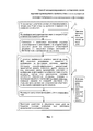
Из уровня техники неизвестны отличительные существенные признаки заявляемого способа, охарактеризованные в формуле изобретения, что подтверждает его соответствие условию патентоспособности изобретательский уровень. Изобретение поясняется блок-схемой на фиг. 1, где позицией I обозначены действия, производимые непосредственно на месте дорожно-транспортного происшествия до освобождения проезжей части от транспортных средств - участников происшествия, а позицией II - действия, производимые на компьютере и с участниками происшествия после освобождения проезжей части от транспортных средств - участников происшествия.The prior art does not know the distinctive essential features of the proposed method, characterized in the claims, which confirms its compliance with the condition of patentability inventive step. The invention is illustrated in the block diagram of FIG. 1, where position I denotes the actions taken directly at the scene of a traffic accident before the carriageway was freed from the vehicles participating in the accident, and position II denotes actions performed on the computer and with the participants of the accident after the carriageway was freed from the vehicles participating in the accident .
Способ осуществляют следующим образом.The method is as follows.
По прибытии на место дорожно-транспортного происшествия размещают четыре или более устройств глобального позиционирования, имеющих видимые сверху метки, в существенных точках участка местности, передают полученные координаты с устройств позиционирования в компьютер, фотографируют участок местности сверху с помощью фотокамеры, расположенной на летательном аппарате вертикального взлета, например на радиоуправляемом квадрокоптере, передают фотографию в компьютер, где совмещают по меткам на фотографии положение устройств позиционирования с их координатами. В компьютере выполняют расчеты по компьютерной программе, в которой определяют размеры, расстояния и высоты на плане участка местности в заданной системе отсчета. Далее дополняют к изображению на фотографии состояние, характер участников дорожно-транспортного происшествия: транспортных средств, пешеходов, других объектов и всех имеющихся следов происшествия, дополняют к изображению на фотографии на выбранном плане участка местности текстом или графическими значками особенности окружающей обстановки, сведения о технических средствах организации дорожного движения, отдельные сведения из показаний участников или очевидцев происшествия или установленные объективно по имеющимся признакам прочие сведения. Затем формируют схему дорожно-транспортного происшествия в электронном виде и/или фотографию участка местности с нанесенной информацией о дорожно-транспортном происшествии, производят распечатку на бумажный носитель схему и/или фотографию дорожно-транспортного происшествия на принтере в принятом размере, например 300×400 мм.Upon arrival at the scene of a traffic accident, four or more global positioning devices with top-visible markers are placed at significant points on the terrain, transmitting the received coordinates from the positioning devices to the computer, photographing the terrain from above using a camera located on the vertical take-off aircraft , for example, on a radio-controlled quadrocopter, they transfer the photo to the computer, where they combine the position of the positioning devices with the marks on the photo Wany with their coordinates. The computer performs calculations according to a computer program, which determines the sizes, distances and heights on the plan of a site in a given reference system. Further, the state and character of the participants in a traffic accident: vehicles, pedestrians, other objects and all available traces of the accident are added to the image on the photo, environmental features, information on technical means are added to the image on the selected plan of the terrain, text or graphic icons traffic management, certain information from the testimonies of the participants or eyewitnesses to the incident or established objectively based on available signs, etc. e information. Then, a traffic accident diagram is generated in electronic form and / or a photograph of the area with the information about the traffic accident printed on paper, a diagram and / or photograph of the traffic accident is printed on a printer in the accepted size, for example 300 × 400 mm .
Пересчет координат системы глобального позиционирования в расстояния и размеры можно выполнить по известным методикам, например, как показано в электронном ресурсе [http://kartaplus.ru/sputpos13].Recalculation of the coordinates of the global positioning system in distances and sizes can be performed according to well-known methods, for example, as shown in the electronic resource [http://kartaplus.ru/sputpos13].
После указанных произведенных действий проезжую часть дороги можно освободить от транспортных средств - участников дорожно-транспортного происшествия.After these actions have been taken, the carriageway can be freed from vehicles participating in a traffic accident.
Вторичную информацию заносят на схему дорожно-транспортного происшествия с помощью специализированного графического редактора:Secondary information is entered on a traffic accident diagram using a specialized graphic editor:
- сведения о технических средствах организации дорожного движения - все имеющиеся на месте происшествии светофоры, дорожные знаки, линии и надписи дорожной разметки в полном соответствии с их действительным расположением на осматриваемом участке,- information about the technical means of organizing traffic - all the traffic lights available at the scene of the accident, road signs, lines and inscriptions of the road markings in full accordance with their actual location on the inspected area,
- отдельные сведения из показаний участников или очевидцев происшествия или установленные объективно по имеющимся признакам (следам) в ходе осмотра места происшествия или непосредственно по его окончании,- individual information from the testimonies of the participants or eyewitnesses of the incident or established objectively by the available signs (traces) during the inspection of the scene of the incident or immediately after it,
- прочие сведения: направление движения участников происшествия; место (точка), с которого производилось фотографирование; воспроизведенный экспериментальным путем или по показаниям водителя путь движения транспортного средства при совершении им какого-либо поворота (так называемая дуга поворота); сведения о продольном и поперечном профиле дороги (закругление, уклон, подъем, вираж), о размещении светильников (в темное время суток) и прочее - по мере необходимости, т.е. отмечают их состояние, характер, указывают текстом или графическими значками особенности окружающей обстановки, сведения о технических средствах организации дорожного движения, отдельные сведения из показаний участников или очевидцев происшествия или установленные объективно по имеющимся признакам прочие сведения.- other information: the direction of movement of the participants in the incident; place (point) from which photographing was made; the vehicle’s path of movement of the vehicle reproduced experimentally or according to the testimony of the driver when he makes any turn (the so-called turn arc); information on the longitudinal and transverse profile of the road (rounding, slope, rise, turn), on the placement of lamps (in the dark), and so on, as necessary, i.e. note their condition, character, indicate with text or graphic icons the features of the environment, information about the technical means of organizing traffic, some information from the testimonies of the participants or eyewitnesses to the incident, or other information established objectively based on available signs.
Предлагаемый способ позволяет существенно уменьшить время составления схемы дорожно-транспортного происшествия, время ограничения или перекрытия движения на месте дорожно-транспортного движения и повысить точность факторов дорожно-транспортного происшествия на основе объективных параметров.The proposed method can significantly reduce the time it takes to compile a traffic accident scheme, the time of restricting or blocking traffic at the place of traffic, and improve the accuracy of the factors of a traffic accident based on objective parameters.
Claims (7)
Priority Applications (1)
| Application Number | Priority Date | Filing Date | Title |
|---|---|---|---|
| RU2015138963A RU2616103C2 (en) | 2015-09-11 | 2015-09-11 | Automated method of charting road traffic accident by using global positioning system and cameras |
Applications Claiming Priority (1)
| Application Number | Priority Date | Filing Date | Title |
|---|---|---|---|
| RU2015138963A RU2616103C2 (en) | 2015-09-11 | 2015-09-11 | Automated method of charting road traffic accident by using global positioning system and cameras |
Publications (2)
| Publication Number | Publication Date |
|---|---|
| RU2015138963A RU2015138963A (en) | 2017-03-23 |
| RU2616103C2 true RU2616103C2 (en) | 2017-04-12 |
Family
ID=58454681
Family Applications (1)
| Application Number | Title | Priority Date | Filing Date |
|---|---|---|---|
| RU2015138963A RU2616103C2 (en) | 2015-09-11 | 2015-09-11 | Automated method of charting road traffic accident by using global positioning system and cameras |
Country Status (1)
| Country | Link |
|---|---|
| RU (1) | RU2616103C2 (en) |
Families Citing this family (1)
| Publication number | Priority date | Publication date | Assignee | Title |
|---|---|---|---|---|
| CN108197356A (en) * | 2017-12-20 | 2018-06-22 | 中国铁路总公司 | A kind of four electric facility location optimization method and devices based on BIM technology |
Citations (5)
| Publication number | Priority date | Publication date | Assignee | Title |
|---|---|---|---|---|
| RU2196697C2 (en) * | 2001-01-22 | 2003-01-20 | Романеев Валерий Анатольевич | Method of revealing road accidents factors |
| RU2248307C1 (en) * | 2004-05-17 | 2005-03-20 | Общество с ограниченной ответственностью "Альтоника" | Ground situation observation system |
| US20060215038A1 (en) * | 2001-05-04 | 2006-09-28 | Gruber Michael A | Large format camera systems |
| RU2507101C1 (en) * | 2012-08-13 | 2014-02-20 | Федеральное государственное бюджетное образовательное учреждение высшего профессионального образования "Иркутский государственный технический университет" (ФГБОУ ВПО "ИрГТУ") | Computer-aided generation of traffic accident scheme |
| RU2562707C2 (en) * | 2009-09-23 | 2015-09-10 | ниармэп острэйлиа пти лтд | Systems and methods of capture of large-area images by parts including cascade cameras and/or calibration attributes |
-
2015
- 2015-09-11 RU RU2015138963A patent/RU2616103C2/en active
Patent Citations (5)
| Publication number | Priority date | Publication date | Assignee | Title |
|---|---|---|---|---|
| RU2196697C2 (en) * | 2001-01-22 | 2003-01-20 | Романеев Валерий Анатольевич | Method of revealing road accidents factors |
| US20060215038A1 (en) * | 2001-05-04 | 2006-09-28 | Gruber Michael A | Large format camera systems |
| RU2248307C1 (en) * | 2004-05-17 | 2005-03-20 | Общество с ограниченной ответственностью "Альтоника" | Ground situation observation system |
| RU2562707C2 (en) * | 2009-09-23 | 2015-09-10 | ниармэп острэйлиа пти лтд | Systems and methods of capture of large-area images by parts including cascade cameras and/or calibration attributes |
| RU2507101C1 (en) * | 2012-08-13 | 2014-02-20 | Федеральное государственное бюджетное образовательное учреждение высшего профессионального образования "Иркутский государственный технический университет" (ФГБОУ ВПО "ИрГТУ") | Computer-aided generation of traffic accident scheme |
Also Published As
| Publication number | Publication date |
|---|---|
| RU2015138963A (en) | 2017-03-23 |
Similar Documents
| Publication | Publication Date | Title |
|---|---|---|
| Elkhrachy | Accuracy assessment of low-cost unmanned aerial vehicle (UAV) photogrammetry | |
| Williams et al. | Synthesis of transportation applications of mobile LiDAR | |
| US8958980B2 (en) | Method of generating a geodetic reference database product | |
| Ning et al. | Exploring the vertical dimension of street view image based on deep learning: a case study on lowest floor elevation estimation | |
| US12189065B2 (en) | Interactive sensor calibration for autonomous vehicles | |
| DE102013216892A1 (en) | Locate an object using visual data | |
| EP3851793A1 (en) | Creating a ground control point file using an existing landmark shown in images | |
| Topolšek et al. | The accuracy analysis of measurement tools for traffic accident investigation | |
| Jurkofsky | Accuracy of SUAS photogrammetry for use in accident scene diagramming | |
| Adjidjonu et al. | Assessing the accuracy of unmanned aerial vehicles photogrammetric survey | |
| RU2507101C1 (en) | Computer-aided generation of traffic accident scheme | |
| Perez Jimeno et al. | An integrated framework for non-destructive evaluation of bridges using UAS: A case study | |
| JP7336415B2 (en) | Repair plan formulation device | |
| Kotov et al. | Engineering tools and methods of estimation of traffic capacity using mobile video monitoring | |
| RU2616103C2 (en) | Automated method of charting road traffic accident by using global positioning system and cameras | |
| CN119334325B (en) | Satellite real-time 3D monitoring and safety hazard early warning system for open-pit mines and tailings ponds | |
| Casierra et al. | Methodology for infrastructure site monitoring using unmanned aerial vehicles (UAVs) | |
| CN114511795A (en) | Method and system for identifying and analyzing flatness of trench bottom and trench side slope of trench | |
| WO2010068185A1 (en) | Method of generating a geodetic reference database product | |
| RU2569454C1 (en) | Method for automated mapping of road accident | |
| Habib et al. | LiDAR-based mobile mapping system for lane width estimation in work zones | |
| Hyung et al. | Review of Indiana Unmanned Aerial System Crash Scene Mapping Program | |
| Wang | Assessing the Application of the Unmanned Aerial Systems (UAS) in Earthwork Volume Measurement | |
| RU2611467C1 (en) | Method of automated making of traffic accident protocol | |
| Williams | Accuracy assessment of LiDAR point cloud geo-referencing |