JP7340887B2 - Driving support system, information generation method, driving support program, and generation program - Google Patents
Driving support system, information generation method, driving support program, and generation program Download PDFInfo
- Publication number
- JP7340887B2 JP7340887B2 JP2022084287A JP2022084287A JP7340887B2 JP 7340887 B2 JP7340887 B2 JP 7340887B2 JP 2022084287 A JP2022084287 A JP 2022084287A JP 2022084287 A JP2022084287 A JP 2022084287A JP 7340887 B2 JP7340887 B2 JP 7340887B2
- Authority
- JP
- Japan
- Prior art keywords
- information
- area
- traffic monitoring
- vehicle
- display
- Prior art date
- Legal status (The legal status is an assumption and is not a legal conclusion. Google has not performed a legal analysis and makes no representation as to the accuracy of the status listed.)
- Active
Links
Images


Landscapes
- Navigation (AREA)
- Traffic Control Systems (AREA)
- Instructional Devices (AREA)
Description
本発明は、車両の現在位置に適した交通監視情報を運転者に提供することによって、運転者の運転を支援する運転支援システム等に関する。 The present invention relates to a driving support system and the like that assists a driver in driving by providing the driver with traffic monitoring information suitable for the current location of the vehicle.
検出対象となる目標物の位置情報を記憶し、GPSにより検出した車両の位置と、その記憶した目標物の位置とが所定の関係になった場合に、運転者に対して警報を発する運転支援システムが知られている。目標物として、例えば、車両速度を測定する装置や取締・検問エリアなどが挙げられる。例えば特許文献1には、目標物と車両との間の距離が設定された距離に至った場合、目標物を特定する情報等をディスプレイ上に表示したり、音声による警報を出力したりできる運転支援システムが提案されている。目標物は、交通事故の発生し易い危険な場所に設置される場合が多い。従って運転支援システムは、目標物への接近を運転者に知らせることで、交通事故の発生しやすい場所において運転者に安全運転を促すことができる。このように、目標物への接近を運転者に知らせることは、運転者の安全運転に寄与するものである。
Driving support that stores the position information of the target object to be detected and issues a warning to the driver when the position of the vehicle detected by GPS and the memorized position of the target form a predetermined relationship. The system is known. Examples of targets include devices that measure vehicle speed, control/inspection areas, and the like. For example, in
安全運転を推進するための監視活動は、不特定の場所で不定期に行われる。該当する監視活動の一例として、警察が行う取締や検問がある。監視活動は、過去の交通事故の発生現場等、交通事故の発生し易い危険な場所で行われる場合が多い。従って、過去に監視活動が行われた場所を目標物として記憶しておき、その場所に車両が近づいた場合に、監視活動に関する情報を運転者に対して提供することで、交通事故の発生し易い場所において運転者に安全運転を促すことができる。以下、安全運転を推進するための監視活動に関する情報を、交通監視情報ともいう。 Monitoring activities to promote safe driving are conducted irregularly at unspecified locations. An example of such surveillance activities is crackdowns and inspections conducted by the police. Monitoring activities are often carried out in dangerous locations where traffic accidents are likely to occur, such as sites where past traffic accidents have occurred. Therefore, by memorizing locations where monitoring activities have been conducted in the past as targets and providing information about the monitoring activities to the driver when a vehicle approaches that location, traffic accidents can be prevented. It is possible to encourage drivers to drive safely in places where it is easy to drive. Hereinafter, information regarding monitoring activities to promote safe driving will also be referred to as traffic monitoring information.
ところが、目標物として記憶される場所は、過去に監視活動が行われた場所であるから、今後も監視活動が行われる可能性は高いものの、運転者がその場所を通過した際に、監視活動が実施されているとは限らない。そこで、これらの機能に加え、各都道府県警察が公表する公開取締情報を報知する装置がある。このような公開取締情報は、所定の地域・時間帯・取締の内容の少なくともいずれか1つが指定されて公表される場合が多い。例えば、監視活動が行われる所定の地域として、県、市区町村、警察の所轄単位、路線等が指定されて公表される。ここで従来の運転支援システムの場合、公開取締情報は各都道府県警察が発表するものであるから、都道府県ごとに交通取締情報を記憶しておき、予めどの都道府県の交通取締情報を報知するかを設定しておいて、エンジン始動等によって装置に電源が入った際に、その設定された都道府県の公開取締情報を報知する。通常、自宅のある県が、どの都道府県の交通取締情報を報知するかの設定情報として予め登録される。そのため従来の運転支援システムは、自宅の位置として設定した都道府県の範囲の公開取締情報が報知されるため、実際には自宅から相当離れた場所にいる場合であっても、自宅の位置を含む都道府県内全体の公開取締情報が報知されることとなる。また、監視活動が行われる所定の地域が自宅から相当離れた場所であっても、自宅と同一の都道府県内であれば、その公開取締情報はすべて報知されることとなる。そのため、運転者にとっては、関係のない離れた場所の情報が報知されてしまうという問題があった。しかも、このような多くの情報の中に、自宅の近くの公開取締情報がまぎれてしまい、本当に必要な自宅近くの公開取締情報を見逃す可能性があった。都道府県の範囲は、自宅からは相当な距離がある範囲(通常、通勤等によって移動する範囲を大きく超えた範囲)をも含んでしまうからである。 However, since the locations that are stored as targets are locations where surveillance activities have been conducted in the past, there is a high possibility that surveillance activities will continue to be conducted in the future. It does not necessarily mean that it is being implemented. Therefore, in addition to these functions, there is a device that notifies public enforcement information published by each prefectural police. Such public enforcement information is often made public by specifying at least one of a predetermined region, time period, and details of the enforcement. For example, prefectures, cities, wards, towns, villages, police departments, routes, etc. are designated and announced as predetermined areas where surveillance activities are to be carried out. In the case of conventional driving support systems, public enforcement information is announced by the police in each prefecture, so traffic enforcement information is stored for each prefecture and the traffic enforcement information for which prefecture is announced in advance. When the device is powered on, such as by starting the engine, public enforcement information for the prefecture in which it has been set will be notified. Usually, the prefecture where a person's home is located is registered in advance as setting information for which prefecture's traffic enforcement information is to be broadcast. For this reason, conventional driving support systems report public enforcement information within the prefecture set as the location of your home, so even if you are actually quite far away from your home, it includes your home location. Public enforcement information for the entire prefecture will be reported. Furthermore, even if the predetermined area where surveillance activities are carried out is quite far from one's home, if it is within the same prefecture as one's home, all public enforcement information will be reported. Therefore, there is a problem in that information about a distant location that is irrelevant to the driver is reported. Moreover, public enforcement information near one's home may be mixed up in such a large amount of information, and there is a possibility that the user may miss the really necessary public enforcement information near one's home. This is because the range of prefectures includes ranges that are a considerable distance from home (ranges that far exceed the range that people usually travel to for work, etc.).
また従来の運転支援システムでは、各都道府県が公開取締情報を発表することから、都道府県ごとに情報を報知すればよいという単純な思想に基づいて、高速道路の路線上に、県境を特定するための位置情報を目標物として記憶しておき、この位置に接近した場合または通過した場合に、その都道府県の公開取締情報を報知するものがあった。この構成では、車両が高速道路上を走行している場合には、県境の位置を検出することができるので、監視活動が行われている都道府県に車両が近づいたことを検出し、運転者にその都道府県の交通監視情報を通知することができる。ところが、車両が一般道を走行している場合には、従来の運転支援システムでは、交通監視情報運転者に通知することができないという問題点がある。また、高速道路を走行していて、その都道府県の公開取締情報が報知された場合でも、実際にはその監視活動が行われる場所が、その県境からは相当離れた場所である可能性がある。そのため、運転者にとっては、関係のない離れた場所の交通取締情報が報知されてしまうという問題があった。しかも、このような多くの情報の中に、その県境の近くの公開取締情報がまぎれてしまい、本当に必要な近くの公開取締情報を見逃す可能性があった。 In addition, in conventional driving support systems, each prefecture releases public enforcement information, so based on the simple idea that information should be reported for each prefecture, prefectural boundaries are identified on expressway routes. There is a system that stores information on the location of a target as a target, and when the user approaches or passes this location, public enforcement information for that prefecture is announced. With this configuration, when a vehicle is traveling on an expressway, the location of the prefectural border can be detected, so when the vehicle approaches the prefecture where surveillance activities are being carried out, it can be detected and the driver can be notified of traffic monitoring information for that prefecture. However, when a vehicle is driving on a general road, there is a problem in that conventional driving support systems cannot notify the driver of traffic monitoring information. Furthermore, even if you are driving on an expressway and are notified of public enforcement information for that prefecture, the location where the surveillance activity is actually carried out may be quite far away from the prefectural border. . Therefore, there is a problem in that the driver is informed of traffic enforcement information from a distant location that is irrelevant to the driver. Furthermore, public enforcement information near the prefectural border may be mixed up in such a large amount of information, and there is a possibility of missing the really necessary public enforcement information near the prefectural border.
本発明の目的は、従来のように単純に都道府県単位で交通監視情報を報知するのではなく、車両の現在位置に適した交通監視情報を運転者に提供することができる運転支援システム等を提供することにある。 The purpose of the present invention is to develop a driving support system that can provide drivers with traffic monitoring information that is appropriate for the current location of the vehicle, rather than simply reporting traffic monitoring information on a prefecture-by-prefecture basis as in the past. It is about providing.
本発明の第一態様に係る運転支援システムは、土地が区画されることで形成される領域である区画領域を識別するための領域識別情報と、前記区画領域の位置を特定するための領域位置情報とが対応付けられて記憶された第一記憶手段の記憶内容に基づいて、車両の位置を含む前記区画領域の前記領域識別情報を取得する第一取得手段と、交通の監視活動に関する情報である交通監視情報であって、前記監視活動が実施される地域を含む前記区画領域の前記領域識別情報が対応付けられた交通監視情報が記憶された第二記憶手段の記憶内容に基づいて、前記第一取得手段によって取得された前記領域識別情報が対応付けられた前記交通監視情報を取得する第二取得手段と、前記第二取得手段によって取得された前記交通監視情報に基づく表示情報を表示手段に表示するための制御を行う第一制御手段とを備えている。 The driving support system according to the first aspect of the present invention includes area identification information for identifying a partitioned area, which is an area formed by partitioning land, and an area position for identifying the position of the partitioned area. a first acquisition means for acquiring the area identification information of the divided area including the position of the vehicle based on the stored content of the first storage means in which the information is stored in association with the information; Based on the storage contents of the second storage means in which certain traffic monitoring information is stored, the traffic monitoring information is associated with the area identification information of the divided area including the area where the monitoring activity is carried out. a second acquisition means for acquiring the traffic monitoring information associated with the area identification information acquired by the first acquisition means; and a display means for displaying display information based on the traffic monitoring information acquired by the second acquisition means. and a first control means for controlling display on the screen.
第一態様によれば、運転支援システムは、車両が位置する区画領域を、第一記憶手段に記憶された記憶内容に基づいて特定できる。また運転支援システムは、監視活動が実施される場所を含む区画領域を、第二記憶手段に記憶された内容に基づいて特定できる。例えば運転支援システムは、第一記憶手段に記憶された記憶内容を参照することによって、車両が位置する区画領域を特定し、第二記憶手段に記憶された記憶内容を参照することによって、監視活動が実施される場所を含む区画領域を特定する。これらによって運転支援システムは、車両が位置する区画領域において監視活動が実施されているか否かを特定できる。従って運転支援システムは、車両が位置する区画領域に対応する交通監視情報に基づき表示情報を作成し、運転者に報知することができる。このため運転者は、従来のように、自宅の属する都道府県を運転支援システムに設定しておく必要がない。また運転支援システムは、高速道路でない一般道路上を走行中であっても、その車両が位置する区画領域に対応する交通監視情報を報知することができる。 According to the first aspect, the driving support system can specify the partitioned area in which the vehicle is located based on the memory content stored in the first storage means. Further, the driving support system can specify a divided area including a place where the monitoring activity is to be performed based on the content stored in the second storage means. For example, the driving support system identifies the partitioned area in which the vehicle is located by referring to the memory contents stored in the first memory means, and performs monitoring activities by referring to the memory contents stored in the second memory means. Identify the demarcated area that includes the location where the These allow the driving assistance system to identify whether monitoring activities are being carried out in the area where the vehicle is located. Therefore, the driving support system can create display information based on the traffic monitoring information corresponding to the divided area where the vehicle is located, and can notify the driver of the display information. Therefore, the driver does not need to set the prefecture to which his or her home belongs in the driving support system, unlike in the past. Further, the driving support system can notify traffic monitoring information corresponding to the divided area in which the vehicle is located even when the vehicle is traveling on a general road other than a highway.
例えば運転支援システムは、監視活動が実施される場所として所定の地域が指定され公表される場合であっても、所定の地域を少なくとも含む区画領域に車両が進入したか否かを特定することができる。所定の地域として、例えば、県、市区町村、警察の所轄単位、路線等が挙げられる。このため運転支援システムは、車両の位置に適した交通監視情報を取得して表示情報を作成し、運転者に提供することができる。運転者は、車両の現在位置の近くで実施されている監視活動を容易に把握することができる。監視活動は、交通事故が発生し易い場所で実施される場合が多い。従って運転者は、現在位置が交通事故の発生し易い危険な場所であることを認識することによって、安全に留意して運転を行うことができる。このようにして運転支援システムは、交通事故の発生を未然に防止することができる。 For example, even if a predetermined area is designated and announced as a location where monitoring activities will be carried out, a driving assistance system may be unable to identify whether a vehicle has entered a partitioned area that includes at least the predetermined area. can. Examples of the predetermined area include prefectures, cities, wards, towns, villages, police departments, routes, and the like. Therefore, the driving support system can acquire traffic monitoring information suitable for the location of the vehicle, create display information, and provide it to the driver. The driver can easily understand monitoring activities being carried out near the current location of the vehicle. Monitoring activities are often carried out in locations where traffic accidents are likely to occur. Therefore, by recognizing that the current location is a dangerous place where a traffic accident is likely to occur, the driver can drive with safety in mind. In this way, the driving support system can prevent traffic accidents from occurring.
第二記憶手段には、監視活動が実施されている地域を含む交通監視情報が記憶されている。従って運転支援システムは、車両の近くで実際に実施されている監視活動に関する交通監視情報を、車両の位置から容易に特定することができる。運転支援システムは、車両の近くで実施されている監視活動に関する情報を短時間で且つ正確に取得し、運転者に提供することができる。特に、第二記憶手段に記憶する交通監視情報には各都道府県警察によって発表される監視活動の実施地域の情報を含み、第二取得手段によって取得する交通監視情報にはこの各都道府県警察によって発表される監視活動の実施地域の情報を含んでおり、交通監視情報に基づく表示情報としてこの監視活動の実施地域の情報を表示するとよい。このようにすれば、運転者は、直接、各都道府県警察によって発表された監視活動の実施地域を、その監視活動が行なわれる区画領域で知ることができる。 The second storage means stores traffic monitoring information including areas where monitoring activities are being carried out. Therefore, the driving support system can easily identify traffic monitoring information regarding monitoring activities actually being carried out near the vehicle from the location of the vehicle. The driving assistance system can quickly and accurately obtain information about monitoring activities being carried out near the vehicle and provide the information to the driver. In particular, the traffic surveillance information stored in the second storage means includes information on the areas where surveillance activities are carried out announced by each prefectural police, and the traffic surveillance information acquired by the second acquisition means includes information announced by each prefectural police. It includes information on the area where the monitoring activity to be announced is carried out, and it is preferable to display the information on the area where the monitoring activity is carried out as display information based on the traffic monitoring information. In this way, the driver can directly know the areas announced by the prefectural police in which the surveillance activities will be carried out in the divided areas where the surveillance activities will be carried out.
また第一態様において、前記区画領域によって特定される領域は、都道府県よりも小さくてもよい。これによって運転支援システムは、都道府県よりも小さい単位の領域、例えば市区町村等を区画領域とすることができる。これによって運転支援システムは、市区町村単位で車両の位置を特定し、車両の近くで実施されている監視活動に関する交通監視情報を取得することができる。このように運転支援システムは、車両の位置を詳細に特定することができるので、車両のより近くで実施されている監視活動に関する情報を報知することができる。 Further, in the first aspect, the area specified by the divided area may be smaller than a prefecture. As a result, the driving support system can define a region smaller than a prefecture, such as a city, ward, town, or village, as a divided region. This allows the driving support system to identify the location of the vehicle on a city, ward, town, or village basis and obtain traffic monitoring information regarding monitoring activities being conducted near the vehicle. In this way, the driving support system can specify the location of the vehicle in detail, and therefore can report information regarding monitoring activities being carried out closer to the vehicle.
また第一態様において前記交通監視情報に対応付けられる前記領域識別情報によって識別される前記区画領域は、前記交通監視情報の基となる情報である基情報が発表される場合に指定される前記監視活動の実施地域とは異なっていてもよい。これによって運転支援システムは、公表される監視活動の実施地域の指定方法(都道府県、市区町村、管轄、路線等)に関わらず、共通の領域識別情報が対応付けられた交通監視情報を参照することができる。これによって運転支援システムは、車両の近くで実施されている監視活動を確実に特定することができる。 Further, in the first aspect, the divided area identified by the area identification information associated with the traffic monitoring information is the monitoring area specified when base information that is the base information of the traffic monitoring information is announced. It may be different from the area where the activity will be carried out. As a result, the driving support system can refer to traffic monitoring information that is associated with common area identification information, regardless of how the announced implementation area of monitoring activities is specified (prefecture, city, town, village, jurisdiction, route, etc.) can do. This allows the driving assistance system to reliably identify monitoring activities being carried out in the vicinity of the vehicle.
また第一態様において、前記基情報は、複数の都道府県の警察によって発表され、且つ、前記基情報が発表される場合に指定される前記監視活動の実施地域の単位は、前記基情報毎に異なっており、前記区画領域は、行政区画の単位で領域を特定しており、複数の都道府県の警察によって発表された複数の前記基情報に基づいて作成された複数の交通監視情報は、前記領域識別情報が対応付けられていてもよい。これによって運転支援システムは、発表される監視活動の実施地域の特定方法(都道府県、市区町村、管轄、路線等)が多岐にわたっている場合でも、共通の区画領域に基づいて、車両の近くで実施されている監視活動を特定することができる。従って運転支援システムは、車両の近くで実施されている監視活動を容易に特定することができる。 Further, in the first aspect, the basic information is announced by police in a plurality of prefectures, and the unit of implementation area of the monitoring activity specified when the basic information is announced is determined for each of the basic information. The division area is different from the above, and the area is specified in units of administrative divisions, and the plurality of traffic monitoring information created based on the plurality of basic information announced by the police of plural prefectures is Area identification information may also be associated. This allows the driving assistance system to locate the area near the vehicle based on a common demarcation area, even if the announced method of identifying the area where the monitoring activity is carried out varies (prefecture, city, town, village, jurisdiction, route, etc.). Monitoring activities being carried out can be identified. The driving assistance system can thus easily identify monitoring activities being carried out in the vicinity of the vehicle.
また第一態様において、時刻を特定する第一特定手段を備え、前記交通監視情報には、前記監視活動が実施される期間、及び前記領域識別情報が対応付けられており、前記第二取得手段は、前記第一取得手段によって取得された前記領域識別情報が対応付けられ、且つ、前記第一特定手段によって特定された前記時刻との関係が所定の関係を満たす前記期間が対応付けられた前記交通監視情報を取得してもよい。これによって運転支援システムは、現時点で実際に実施されている監視活動や、近々に実施される監視活動に関する情報を、運転者に提供することができる。運転支援システムは、運転者にとってより有用な情報を即座に認識し、提供することができるので、運転者は、交通事故が発生し易い場所での運転をより安全に行うことができる。 Further, in the first aspect, there is provided a first specifying means for specifying a time, the traffic monitoring information is associated with a period in which the monitoring activity is carried out and the area identification information, and the second obtaining means is associated with the area identification information acquired by the first acquisition means and with the period whose relationship with the time specified by the first identification means satisfies a predetermined relationship. Traffic monitoring information may also be obtained. Thereby, the driving support system can provide the driver with information regarding monitoring activities that are actually being performed at the present time and monitoring activities that will be performed soon. Since the driving support system can instantly recognize and provide more useful information to the driver, the driver can drive more safely in areas where traffic accidents are likely to occur.
また第一態様において、前記表示情報は、テキスト情報によって構成され、前記第一制御手段は、前記表示情報をスクロール表示させるための制御を行ってもよい。 Further, in the first aspect, the display information may be constituted by text information, and the first control means may perform control to scroll display the display information.
運転者が運転中に表示手段を視認する場合、短い間隔で繰り返し視線を表示手段に向けることになる。運転者は、運転中に表示手段を長時間連続して視認することができない。このため、表示手段に表示される情報のデータ量が多い場合、表示手段に情報が一度に表示されると、運転者は情報を正確に認識できない可能性がある。これに対して運転支援システムは、テキスト情報をスクロール表示させることによって、表示手段に一度に表示される情報のデータ量を少なくすることができる。これによって運転者は、短い間隔で繰り返し表示手段を視認する場合でも、表示される情報を正確に認識することができる。 When a driver visually recognizes the display means while driving, he or she repeatedly directs his/her line of sight toward the display means at short intervals. The driver cannot continuously view the display means for a long time while driving. Therefore, if the amount of information displayed on the display means is large, and the information is displayed on the display means all at once, the driver may not be able to accurately recognize the information. In contrast, the driving support system can reduce the amount of information displayed at one time on the display means by scrolling and displaying the text information. This allows the driver to accurately recognize the displayed information even when viewing the display means repeatedly at short intervals.
また第一態様において、前記第一制御手段は、スクロール表示によって前記表示情報がすべて表示された場合、前記表示情報を最初から繰り返しスクロール表示させるための制御を行ってもよい。これによって表示情報のスクロール表示は、複数回にわたって繰り返し実行されることになる。これによって運転者は、監視活動に関する情報を一旦見逃してしまった場合でも、再度表示される情報を認識することができる。 Further, in the first aspect, when all of the display information is displayed by scrolling, the first control means may perform control to repeatedly scroll and display the display information from the beginning. As a result, the scrolling display of the display information is repeatedly executed multiple times. This allows the driver to recognize the information that is displayed again even if he or she once misses the information regarding the monitoring activity.
また第一態様において前記交通監視情報は、カテゴリを含んでおり、前記第一制御手段は、前記第二取得手段によって前記交通監視情報が複数取得された場合、取得された前記複数の交通監視情報に基づく前記表示情報を前記カテゴリ毎にまとめて表示するための制御を行ってもよい。これによって、監視活動に関する情報が複数ある場合、各情報はカテゴリごとに分類されて表示される。カテゴリとして、取締情報、検問等がある。運転者は、監視活動に関する情報をカテゴリ毎に区別して認識することが容易に可能となる。 Further, in the first aspect, the traffic monitoring information includes a category, and when a plurality of the traffic monitoring information is acquired by the second acquisition means, the first control means controls the traffic monitoring information of the acquired plurality of traffic monitoring information. Control may be performed to collectively display the display information based on the category. As a result, when there is a plurality of pieces of information related to monitoring activities, each piece of information is classified and displayed by category. Categories include enforcement information, inspection, etc. The driver can easily distinguish and recognize information related to monitoring activities by category.
また第一態様において、前記車両の走行速度を特定する第二特定手段を備え、前記第一制御手段は、前記第二特定手段によって特定された前記車両の走行速度に応じて、前記表示情報がスクロールする場合の表示速度が変化するように表示するための制御を行ってもよい。 Further, in the first aspect, the display information includes second specifying means for specifying the traveling speed of the vehicle, and the first control means adjusts the display information according to the traveling speed of the vehicle specified by the second specifying means. Display control may be performed so that the display speed when scrolling changes.
例えば車両の走行速度が速い場合、運転者は、長時間連続して表示手段に視線を向けることができないことが想定される。このような場合に運転支援システムは、スクロール表示される場合の表示速度を遅くする。これによって運転者は、短い時間内で、表示された情報を確実に認識することができる。一方、例えば車両の走行速度が遅い場合、運転者は、長時間連続して表示手段に視線を向けることが可能となることが想定される。このような場合に運転支援システムは、スクロール表示される場合の表示速度を速くする。これによって運転者は、大量の情報を正確に認識することができる。 For example, when the vehicle is traveling at a high speed, it is assumed that the driver cannot keep his/her eyes on the display means for a long period of time. In such a case, the driving support system slows down the display speed when scrolling. This allows the driver to reliably recognize the displayed information within a short period of time. On the other hand, for example, when the vehicle is traveling at a slow speed, it is assumed that the driver will be able to continuously look at the display means for a long period of time. In such a case, the driving support system increases the display speed when scrolling. This allows the driver to accurately recognize a large amount of information.
また第一態様において、前記第一制御手段は、前記第一取得手段によって取得された前記領域識別情報によって識別される前記区画領域を特定するための情報を、前記表示情報と同時に表示するための制御を行ってもよい。これによって運転者は、車両の現在位置を、監視活動に関する情報と同時に認識することができる。例えば運転者は、監視活動が広域にわたって実施される場合、車両の現在位置が、監視活動が実施される地域のうちどの部分に属しているかを確認することができる。これによって運転者は、安全運転に特に留意するべき場所を把握し、運転を行うことができる。 In the first aspect, the first control means is configured to display information for specifying the divided area identified by the area identification information acquired by the first acquisition means at the same time as the display information. Control may also be performed. This allows the driver to know the current location of the vehicle at the same time as information regarding monitoring activities. For example, if the monitoring activity is carried out over a wide area, the driver can confirm to which part of the area the monitoring activity is carried out the current position of the vehicle belongs. This allows the driver to understand the areas where special attention should be paid to safe driving, and drive accordingly.
また第一態様において、前記車両の位置が変化し、前記第一取得手段によって取得される前記領域識別情報が、前記車両の位置が変更されたことに伴い更新され、前記第二取得手段によって、前記第一取得手段によって取得された前記領域識別情報が更新されたことに伴い新たな前記交通監視情報が取得された場合に、音を出力するための制御を行う第二制御手段を備えていてもよい。これによって運転者は、音によって通知が行われた場合に表示手段を視認することで、更新された表示情報を確実に認識することができる。このようにして運転支援システムは、監視活動に関する情報を運転者が見落としてしまうことを防止できる。 Furthermore, in the first aspect, the position of the vehicle changes, the area identification information acquired by the first acquisition means is updated in accordance with the change in the position of the vehicle, and the second acquisition means A second control means is provided for controlling to output a sound when new traffic monitoring information is acquired as a result of updating of the area identification information acquired by the first acquisition means. Good too. As a result, the driver can reliably recognize the updated display information by visually checking the display means when the notification is made by sound. In this way, the driving support system can prevent the driver from overlooking information regarding monitoring activities.
例えば運転支援システムは、所定の時間間隔(例えば1秒間隔)で車両の位置が特定されてもよいし、車両の移動距離が所定距離以上となった場合に車両の位置が特定されてもよい。そして、このようにして繰り返し特定される車両の位置に基づき、区画領域及び区画領域に対応する交通監視情報が繰り返し特定されてもよい。そして、特定された交通監視情報が新しくなった場合に、音が出力されるように制御してもよい。 For example, the driving support system may specify the location of the vehicle at predetermined time intervals (for example, every second), or may specify the location of the vehicle when the distance traveled by the vehicle exceeds a predetermined distance. . Then, based on the position of the vehicle repeatedly identified in this way, the divided area and the traffic monitoring information corresponding to the divided area may be repeatedly identified. Then, when the specified traffic monitoring information becomes new, control may be performed so that a sound is output.
また第一態様において、前記車両の位置を含む周辺の地図を、前記交通監視情報と同時に表示するための制御を行う第三制御手段を備えていてもよい。これによって運転者は、車両の現在位置の周辺の地理の情報を認識することができる。例えば運転者は、周辺の道路環境を認識することによって、事前に走行速度を減速させたり、事前に周囲の環境に十分注意したりすることができる。このように運転支援システムは、運転者の安全運転のために必要な情報を、交通監視情報と共に運転者に提供することができる。 Further, in the first aspect, the vehicle may include a third control means for controlling to display a map of the surrounding area including the position of the vehicle at the same time as the traffic monitoring information. This allows the driver to recognize geographic information around the current location of the vehicle. For example, by recognizing the surrounding road environment, the driver can reduce the driving speed in advance or pay sufficient attention to the surrounding environment in advance. In this way, the driving support system can provide the driver with information necessary for safe driving, together with traffic monitoring information.
また第一態様において、前記監視活動が実施される地域は、複数の前記区画領域にわたり、前記交通監視情報には、複数の前記領域識別情報が対応付けられていてもよい。これによって運転支援システムは、監視活動が広域にわたって実施されている場合でも、車両の近くで実施されている監視活動に関する情報を正確に特定することができる。 Further, in the first aspect, the area where the monitoring activity is carried out may cover a plurality of the divided areas, and the traffic monitoring information may be associated with a plurality of the area identification information. This allows the driving support system to accurately identify information regarding monitoring activities being carried out near the vehicle, even if the monitoring activities are being carried out over a wide area.
例えば区画領域として、市区町村が第一記憶手段に記憶される場合を仮定する。監視活動が実施される地域として、「~署管内」「~方面」「~号線沿線」等が公表されたとする。このように、公表される地域の単位が区画領域の単位よりも大きい場合であっても、公表される地域の単位よりも細かい単位の区画領域を統一的に交通監視情報に含めることができる。これによって運転支援システムは、車両が位置する区画領域における監視活動に関する情報を、正確且つ容易に特定し、運転者に通知することができる。また運転支援システムは、監視活動が実施される地域が具体的に公表されない場合でも、車両の近くで実施されている監視活動に関する情報を正確に特定し、運転者に提供することができる。 For example, assume that a city, ward, town, or village is stored in the first storage means as a divided area. Suppose that the areas where surveillance activities will be carried out are announced as ``within the jurisdiction of police stations,'' ``in the direction of ~,'' and ``along the lines of ~.'' In this way, even if the announced area unit is larger than the divided area unit, the divided area smaller than the announced area unit can be uniformly included in the traffic monitoring information. Thereby, the driving support system can accurately and easily identify information regarding monitoring activities in the divided area where the vehicle is located, and notify the driver of the information. Furthermore, the driving support system can accurately identify and provide information to the driver regarding the monitoring activities being carried out near the vehicle, even if the area where the monitoring activities are carried out is not specifically announced.
また第一態様において、前記表示情報は、前記監視活動の種別、前記監視活動が実施される期間、及び、前記監視活動が実施される地域のうち少なくともいずれかを含んでいてもよい。これによって運転者は、例えば監視活動の種別として、取締りの重点項目を認識することができる。取締りの重点項目として、速度超過、過積載、シートベルト、飲酒運転、信号無視等が挙げられる。又運転者は、例えば監視活動が実施される地域として、警察管轄、路線、市区町村等を認識することができる。これらによって運転者は、監視活動に関する情報を詳細に把握し、これらの点に特に留意して運転を行うことによって、交通安全に配慮した運転を行うことができる。 Further, in the first aspect, the display information may include at least one of the type of the monitoring activity, the period in which the monitoring activity is carried out, and the area in which the monitoring activity is carried out. This allows the driver to recognize priority items for enforcement, such as the type of monitoring activity. Priority areas for enforcement include excessive speeding, overloading, seat belts, drunk driving, and disregarding traffic lights. The driver can also recognize, for example, the area where the monitoring activity is to be carried out, such as police jurisdiction, route, city, town, village, etc. These allow drivers to understand detailed information regarding monitoring activities and drive with particular consideration to these points, thereby allowing them to drive with consideration for traffic safety.
また第一態様において、前記第一制御手段は、前記種別、前記期間、及び前記地域を、異なる色で表示するための制御を行ってもよい。これによって運転者は、監視活動の種別、期間、及び地域を容易に区別して認識することができる。 Further, in the first aspect, the first control means may perform control to display the type, the period, and the region in different colors. This allows the driver to easily distinguish and recognize the type, period, and area of the monitoring activity.
本発明の第二態様に係る情報生成方法は、第一態様に係る運転支援システムによって参照される前記第二記憶手段に記憶される情報を生成する情報生成方法であって、公表された情報に対応する前記監視活動が実施される地域を少なくとも含む複数の前記区画領域を識別するための領域識別情報を抽出し、抽出された前記領域識別情報が対応付けられた前記交通監視情報を前記第二記憶手段に記憶することを特徴とする。第二態様によれば、公表される監視活動に関する情報のうち地域のカテゴリが、公表される情報毎に異なる場合であっても、共通のカテゴリである領域識別情報が対応付けられた交通監視情報を第二記憶手段に記憶することができる。 An information generation method according to a second aspect of the present invention is an information generation method for generating information stored in the second storage means that is referred to by the driving support system according to the first aspect, and the method includes: Area identification information for identifying a plurality of divided areas including at least the area where the corresponding monitoring activity is carried out is extracted, and the traffic monitoring information to which the extracted area identification information is associated is extracted from the second area. It is characterized by being stored in a storage means. According to the second aspect, even if the regional category of the information regarding monitoring activities to be published differs depending on the information to be published, traffic monitoring information is associated with area identification information that is a common category. can be stored in the second storage means.
公表される地域そのものを識別する領域識別情報が交通監視情報に対応付けられた場合を仮定する。この場合、監視活動が実施される地域を正確に特定できるためより好ましい。しかしながら、公表される地域のカテゴリ(「~署管内」「~方面」「~号線沿線」等)は、公表される情報毎に相違する可能性がある。カテゴリが相違する場合、車両の現在位置において実施されている監視活動に関する情報を特定するためには、第一記憶手段に記憶された領域識別情報によって識別される区画領域のカテゴリを併せて変更する必要があり、煩わしい。また、カテゴリによっては、監視活動が実施される地域を具体的に特定できない場合もある。これに対して第二態様によれば、交通監視情報に対応付けられる領域識別情報のカテゴリは統一されるので、公表される地域のカテゴリが変更された場合であっても、第一記憶手段に記憶された領域識別情報を変更する必要がない。 Assume that area identification information that identifies the area itself to be announced is associated with traffic monitoring information. In this case, it is more preferable because the area where the monitoring activities are to be carried out can be accurately specified. However, the categories of regions that are published (such as "within police station jurisdiction," "area," "along railway line," etc.) may differ depending on the information published. If the categories are different, the category of the divided area identified by the area identification information stored in the first storage means is also changed in order to specify information regarding the monitoring activity being carried out at the current location of the vehicle. Necessary and annoying. Furthermore, depending on the category, it may not be possible to specifically identify the area where monitoring activities will be carried out. On the other hand, according to the second aspect, the category of area identification information associated with traffic monitoring information is unified, so even if the category of the area to be announced is changed, it is stored in the first storage means. There is no need to change the stored area identification information.
また第二態様において、前記抽出は、前記公表された情報に対応する前記監視活動が実施される地域と、前記地域を少なくとも含む前記複数の区画領域の前記領域識別情報とが対応付けて記憶された第三記憶手段を参照することによって、前記複数の区画領域を識別するための領域識別情報を抽出してもよい。これによって、公表された交通監視情報に対応する領域識別情報を容易に特定し、交通監視情報に対応付けることができる。 In a second aspect, the extraction includes storing a region in which the monitoring activity corresponding to the published information is carried out in association with the region identification information of the plurality of divided regions including at least the region. The area identification information for identifying the plurality of divided areas may be extracted by referring to the third storage means. Thereby, it is possible to easily specify the area identification information corresponding to the published traffic monitoring information and associate it with the traffic monitoring information.
本発明の第三態様に係る運転支援プログラムは、本発明の第一態様に係る運転支援システムの各処理手段をコンピュータに実行させる。これによって、第一態様と同様の効果を奏することができる。 The driving support program according to the third aspect of the present invention causes a computer to execute each processing means of the driving support system according to the first aspect of the present invention. With this, the same effects as the first aspect can be achieved.
本発明の第四態様に係る生成プログラムは、本発明の第一態様に係る運転支援システムによって参照される前記第二記憶手段に記憶される情報を生成するための生成プログラムであって、公表された情報に対応する前記監視活動が実施される地域を少なくとも含む複数の前記区画領域を識別するための領域識別情報を抽出し、抽出された前記領域識別情報が対応付けられた前記交通監視情報を前記第二記憶手段に記憶することをコンピュータに実行させることができる。 The generation program according to the fourth aspect of the present invention is a generation program for generating information stored in the second storage means referred to by the driving support system according to the first aspect of the present invention, and is not publicly available. extracting area identification information for identifying a plurality of divided areas including at least the area where the monitoring activity corresponding to the information is carried out; and extracting the traffic monitoring information to which the extracted area identification information is associated. A computer can be caused to store the information in the second storage means.
なお本発明は、第一態様に係る運転支援システムと、前記第二記憶手段に記憶される情報を生成する情報生成装置とを備えたシステムであってもよい。情報生成装置は、公表された情報に対応する前記監視活動が実施される地域を少なくとも含む複数の前記区画領域を識別するための領域識別情報を抽出する抽出手段と、前記抽出手段によって抽出された複数の前記領域識別情報が対応付けられた前記交通監視情報を、前記第二記憶手段に記憶する記憶制御手段とを備えていてもよい。また前記抽出手段は、前記公表された情報に対応する前記監視活動が実施される地域と、前記地域を少なくとも含む前記複数の区画領域を識別するための領域識別情報とが対応付けて記憶された第三記憶手段を参照することによって、前記複数の領域識別情報を抽出してもよい。 Note that the present invention may be a system including the driving support system according to the first aspect and an information generation device that generates information to be stored in the second storage means. The information generation device includes an extraction means for extracting area identification information for identifying a plurality of divided areas including at least an area in which the monitoring activity corresponding to the published information is carried out, and an area identification information extracted by the extraction means. It may also include storage control means for storing the traffic monitoring information associated with a plurality of the area identification information in the second storage means. Further, the extraction means stores a region in which the monitoring activity corresponding to the published information is carried out, and region identification information for identifying the plurality of divided regions including at least the region, in association with each other. The plurality of area identification information may be extracted by referring to the third storage means.
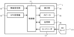
以下、本発明に係る運転支援システムの一実施形態である運転支援システム1について、図面を参照して説明する。これらの図面は、本発明が採用しうる技術的特徴を説明するために用いられるものである。記載されている装置の構成、各種処理のフローチャート等は、それのみに限定する趣旨ではなく、単なる説明例である。運転支援システム1の具体例としては、例えばレーダ探知システム、カーナビゲーションシステム等が挙げられる。なお運転支援システム1は、単一の機器によって実現されてもよいし、複数の機器によって実現されても良い。図1に示すように、運転支援システム1は、制御全体を司る制御部11を備えている。制御部11は、CPU、ROM、RAM、I/O、周辺回路等を含むマイコン等で構成され、無線受信部12、GPS受信部13、表示部14、スピーカ15、記憶部16、及びカードリーダ17と電気的に接続している。ROMには、制御部11のプログラムが少なくとも記憶される。これらのハードウェア構成は従来と同様のものを用いることができる。
Hereinafter, a driving
無線受信部12は、無線信号を受信するための無線モジュールである。無線受信部12において受信される無線信号の具体例として、速度測定装置から出力されるレーダ信号、取締り連絡用無線機から送信される無線信号、各警察本部と移動局との間で送受信されるデジタル無線信号、警察専用の自動車携帯電話システムにおいて使用される無線信号、及び、緊急車両から送信される無線信号等が挙げられる。無線受信部12は、複数の周波数の無線信号を区別して受信するために、複数の無線モジュールを備えていてもよい。無線受信部12は、無線信号を受信した場合、受信した無線信号の信号レベルを検出し、Received Signal Strength Indication(RSSI)として出力する。制御部11は、無線受信部12から出力されたRSSIの電圧レベルに基づいて、受信された無線信号の信号レベルを認識し、無線信号を送信した対象物と自車両との間の距離を予測することができる。
The
GPS受信部13は、GPS衛星から送信される無線信号を受信するための無線モジュールである。GPS受信部13は、受信した無線信号に基づいて自車両の位置情報を検出し、出力する。位置情報は、自車両位置の緯度及び経度である。制御部11は、GPS受信部13から出力された位置情報に基づいて、自車両位置を特定する。
The
表示部14は、例えば液晶ディスプレイ、及びELディスプレイ等である。制御部11は、表示部14を制御して所望の画像を表示させることができる。また制御部11は、スピーカ15を制御して所望の音を出力させることができる。カードリーダ17は、SDカード171にアクセスするためのインタフェースである。制御部11は、カードリーダ17を介して、SDカード171に記憶された情報を読み出すことができる。
The
記憶部16は、各種情報を記憶する不揮発性記憶素子である。記憶部16は、例えばEEPROM、フラッシュメモリ、ハードディスクドライブ等である。記憶部16には、地図データ、表示部14に表示される画像のデータ、スピーカ15から出力される音のデータ、及び各種データベースが記憶されている。各種データベースには、第一DB、及び第二DBが少なくとも含まれる。
The
第一DBには、位置情報に基づいて行政区画を特定することができるポリゴンデータが記憶されている。行政区画は市区町村毎に定められている。以下、行政区画によって表される領域を、区画領域ともいう。ポリゴンデータには、区画領域を識別するための領域識別情報が対応付けられている。制御部11は、GPS受信部13から出力される位置情報に基づいて第一DBを参照することによって、自車両が位置する区画領域を識別するための領域識別情報を、都道府県単位よりも小さい市区町村単位で特定することができる。なお本発明における区画領域によって表される領域は、市区町村に限定されず、他の領域を表すものであってもよい。
The first DB stores polygon data that can identify administrative divisions based on location information. Administrative divisions are determined for each city, ward, town, or village. Hereinafter, the area represented by the administrative division will also be referred to as a divided area. The polygon data is associated with area identification information for identifying divided areas. The control unit 11 refers to the first DB based on the position information output from the
第二DBには、運転者に報知する目標物に関する情報が記憶されている。目標物として例えば、速度測定装置(レーダのようにレーダ波(マイクロ波)を発する速度測定装置や、ループコイルのように、レーダ波を発しない速度測定装置を含む)、制限速度切替りポイント、取締エリア、検問エリア、駐禁監視エリア、Nシステム、交通監視システム、交差点監視ポイント、信号無視抑止システム、警察署、事故多発エリア、車上狙い多発エリア、急/連続カーブ(高速道)、分岐/合流ポイント(高速道)、ETCレーン事前案内(高速道)、サービスエリア(高速道)、パーキングエリア(高速道)、パーキングエリア(高速道)、ハイウェイオアシス(高速道)、スマートインターチェンジ(高速道)、PA/SA内ガソリンスタンド(高速道)、トンネル(高速道)、ハイウェイラジオ受信エリア(高速道)、県境告知、道の駅、ビューポイントパーキング等がある。以下、運転者に報知する目標物を、報知対象物ともいう。第二DBには、報知対象物の種別を示す情報、報知対象物の位置を示す緯度及び経度の情報、表示部14に表示する模式図または写真のデータ、及び、スピーカ15から出力する音のデータが対応付けられて記憶されている。制御部11は、GPS受信部13から出力される位置情報に基づいて第二DBを参照することによって、自車両の近くにある報知対象物を特定することができる。
The second DB stores information regarding targets to be notified to the driver. Examples of targets include speed measuring devices (including speed measuring devices that emit radar waves (microwaves) like radar and speed measuring devices that do not emit radar waves like loop coils), speed limit switching points, Enforcement area, inspection area, parking monitoring area, N system, traffic monitoring system, intersection monitoring point, signal disregard prevention system, police station, accident-prone area, vehicle-targeting area, sharp/continuous curves (highway), branch/ Merging point (expressway), Advance ETC lane guidance (expressway), Service area (expressway), Parking area (expressway), Parking area (expressway), Highway oasis (expressway), Smart interchange (expressway) , PA/SA gas stations (expressways), tunnels (expressways), highway radio reception areas (expressways), prefectural border announcements, roadside stations, view point parking, etc. Hereinafter, the target object to be notified to the driver will also be referred to as a notification target object. The second DB contains information indicating the type of the target object, latitude and longitude information indicating the position of the target object, data of a schematic diagram or photograph to be displayed on the
第一DB及び第二DBは、運転支援システム1の出荷時に記憶部16に記憶される。また第一DB及び第二DBは、周知の手法によって更新することが可能である。例えば第一DB及び第二DBは、SDカード171に記憶されてもよい。カードリーダ17を介してSDカード171から読み出された第一DB及び第二DBが、記憶部16に記憶されることによって、第一DB及び第二DBが更新されてもよい。また例えば運転支援システム1は、赤外線通信機能を備えていてもよい。外部機器と赤外線通信が行われて第一DB及び第二DBが取得され、記憶部16に記憶されることによって、第一DB及び第二DBが更新されてもよい。
The first DB and the second DB are stored in the
SDカード171には、交通監視情報が複数格納された第三DBが記憶されている。交通監視活動は、安全運転を推進するための監視活動に関する情報である。監視活動の一例として、警察が行う取締りや検問がある。監視活動は、不特定の場所で不定期に行われる。制御部11は、第三DBを参照することによって、自車両の近くで実施されている監視活動の詳細を特定することができる。
The
図2を参照し、第三DBの詳細について説明する。インデックス1~15に格納されている其々の情報のうち、下段に格納された情報が、交通監視情報に相当する。交通監視情報には、監視活動が実施される「都道府県」、「開始日」、「開始時間」、「終了日」、「終了時間」、監視活動を行う「管轄」警察署、及び「実施場所」が対応付けられている。例えば、図2のうちインデックス2の情報(「開始日:20110307」「開始時間:12h00m」「終了日:20110307」「終了時間:18h00m」「管轄:岩手県警」「実施場所:葛巻町:302」、「交通監視情報:[取締り]午後 岩手県警~」)は、2011年3月7日 12時00分から18時00分までの間、岩手県警の管轄で、葛巻町内のいずれかの地域において取締りが行われることを意味している。「実施場所」のうち302は、市区町村を特定するための領域識別情報である。
Details of the third DB will be explained with reference to FIG. 2. Among the information stored in
交通監視情報として、監視活動に関するテキスト情報が格納される。交通監視情報として格納されたテキスト情報は、表示部14に表示されるメッセージとしてそのまま使用される。テキスト情報のうち[]で囲まれた部分には、監視活動のカテゴリが格納される。交通監視情報として格納されたテキスト情報の文言は、運転者が運転しなから(チラ見しながら)でも内容を把握することができるように、「なにを」「いつ」「どこで」の構成が単文でつづられている。「なにを」の情報は、例えば「速度違反」「飲酒」「一時停止」などの取締りの内容を示す。「いつ」の情報は、監視活動が実施される時間帯や日付を示す。「どこで」の情報は、例えば、監視活動が実施される住所や路線を示す。
Text information regarding monitoring activities is stored as traffic monitoring information. The text information stored as traffic monitoring information is used as is as a message displayed on the
交通監視情報は、全国の各都道府県警察のホームページ(以下、HPという。)を介して公表される情報が、所定のフォーマットに基づいてデータ化されたものである。制御部11は、交通監視情報に基づくメッセージを、その内容に沿った場所及び時間で、表示部14にテロップ表示する。運転者は、テロップ表示されたメッセージに気付くことで、安全運転に心がけるようになる。交通監視情報には、監視活動の種別(「なにを」)、監視活動が実施される期間(「いつ」)、及び、監視活動が実施される地域(「どこで」)が含まれている。このため、交通監視情報に基づいてメッセージが作成され、運転者に通知された場合、運転者は、例えば監視活動の種別として、取締りの重点項目を認識することができる。取締りの重点項目として、例えば、速度超過、過積載、シートベルト、飲酒運転、信号無視等が挙げられる。又例えば運転者は、監視活動が実施される地域として、警察管轄、路線、市区町村等を認識することができる。これらによって運転者は、交通監視情報を詳細に把握し、これらの点に特に留意して運転を行うことによって、交通安全に配慮した運転を行うことができる。以下、監視活動に関する情報であって全国の各都道府県警察のHPを介して公表される情報を総称し、公開取締情報ともいう。
Traffic monitoring information is information published via the homepages (hereinafter referred to as "HPs") of each prefectural police force across the country, converted into data based on a predetermined format. The control unit 11 displays a message based on the traffic monitoring information as a telop on the
第三DBに格納される情報は、全国の各都道府県警察のHPを介して公表されている取締り情報を、オペレータがデータ化することによって作成される。図2に示すように、公表された公開取締情報から、実施日、時間帯、場所、種別等をなるべく同じ文言で抽出してデータ化し、交通監視情報に対応付けてある。公開取締情報は、各都道府県警察のHPを介して公表されるため、図2に示すように、其々の交通監視情報は都道府県毎にまとめられている。また其々の情報は、日付、時間帯、管轄、市区町村、もしくは取締り種別毎に1件分とされている。交通監視情報は、SDカード171の記憶容量に制限があるため、短めに且つ解りやすくまとめられている。なお、公表される公開取締情報によっては、第三DBに格納される情報のうち特定の項目について公表されない場合がある。このような場合、オペレータは、公表されなかった項目に対応する情報をデータ化しない。このためこのような場合、公表されなかった項目には情報は格納されない。
The information stored in the third DB is created by an operator converting enforcement information published through the websites of each prefectural police nationwide into data. As shown in Figure 2, the date, time, location, type, etc. of enforcement are extracted from the published public enforcement information using as much of the same wording as possible, converted into data, and correlated with traffic monitoring information. Since the public enforcement information is made public via the homepage of each prefectural police, the traffic monitoring information is compiled for each prefecture, as shown in Figure 2. Each piece of information is divided into one case per date, time zone, jurisdiction, city, town, village, or enforcement type. Since the storage capacity of the
なお交通監視情報に対応付けられる項目は、上述に限定されない。オペレータが第三DBに格納される情報を作成する場合の効率が改善されるように、其々の項目はまとめられてもよい。 Note that the items associated with traffic monitoring information are not limited to the above. Each item may be grouped together to improve efficiency when an operator creates information to be stored in the third DB.
交通監視情報に対応付けられる「実施場所」には、市区町村単位で区画領域を識別するための領域識別情報が格納される。このため例えば、監視活動が実施される場所として公表された情報が「県道」等のように、複数の市区町村にまたがるような場合、該当する市区町村を識別する領域識別情報は、すべて「実施場所」とされる。例えば図2の第三DBのうちインデックス5の情報では、「県道」において監視活動が実行される場合に、「実施場所」として、領域識別情報「302(葛巻町)」「501(軽米町」」及び「209(一関市)」が、交通監視情報に対応付けられている。このように、監視活動が広域にわたって公開されている場合、複数の領域識別情報が共通の交通監視情報に対応付けられる。これによって、監視活動が実施される地域を明確化している。
The "implementation location" associated with the traffic monitoring information stores area identification information for identifying divided areas on a city, ward, town, or village basis. Therefore, for example, if information published as a location where monitoring activities are carried out spans multiple cities, wards, towns and villages, such as "prefectural roads," all area identification information that identifies the applicable cities, wards, towns and villages is It is referred to as the “place of implementation.” For example, in the information of
ここで前述したように、第一DBには、市区町村単位で領域識別情報を特定可能なポリゴンデータが記憶されているので、自車両の位置する区画領域の領域識別情報は、市区町村単位で特定される。自車両の位置する区画領域の領域識別情報と、交通監視情報に「実施場所」として対応付けられている領域識別情報は、何れも市区町村単位であり同一である。このため、自車両が位置している区画領域と同一の地域を、交通監視情報における「実施場所」から画一的に検索することができるので、自車両の近くで実施されている監視活動の交通監視情報を容易に特定することができる。 As mentioned above, the first DB stores polygon data that allows area identification information to be specified in units of cities, wards, towns and villages, so the area identification information of the divided area where the own vehicle is located can be determined by city, ward, town, or village. Specified in units. The area identification information of the divided area in which the own vehicle is located and the area identification information associated with the traffic monitoring information as the "implementation location" are the same for each city, ward, town, or village. Therefore, it is possible to uniformly search for the same area as the area where the own vehicle is located from the "place of implementation" in the traffic monitoring information, so it is possible to uniformly search for the same area as the area in which the own vehicle is located. Traffic monitoring information can be easily identified.
例えば、監視活動が実施される地域が、A県警では「~署管内」、B県警では「~方面」、C県警では「~号線沿線」のように、地域の単位で公開取締情報が公表されたとする。このように、公開取締情報は、公表元の都道府県警察毎に、監視活動が実施される地域の単位が異なっている。このような場合でも、すべての都道府県警の発表する公開取締情報において、市区町村単位の区画領域を識別する領域識別情報を交通監視情報に対応付け、「実施場所」として統一的に利用する。各都道府県警によって公表される地域と、交通監視情報に対応する区画領域とは、単位が異なることになる。これによって運転支援システム1は、車両が位置する区画領域にて実施されている監視活動に関する交通監視情報を、統一的、正確、且つ容易に特定することができる。従って上述のように、監視活動が実施される地域が具体的に特定できない状態で公表された場合でも、運転支援システム1は、車両の近くで実施されている監視活動に関する情報を正確に特定することができる。
For example, if the area where surveillance activities are carried out is ``within the jurisdiction of ~ police station'' for Prefectural Police A, ``area ~ area'' for Prefectural Police police B, and ``along the lines of ~ line'' for Prefectural police C, public enforcement information is released on a regional basis. Suppose that In this way, public enforcement information differs in the area in which surveillance activities are carried out, depending on the prefectural police that publishes it. Even in such cases, in all public enforcement information released by prefectural police, area identification information that identifies demarcated areas by city, ward, town, or village will be associated with traffic monitoring information and used uniformly as "implementation locations." . The area announced by each prefectural police and the divided area corresponding to traffic monitoring information have different units. Thereby, the driving
公開取締情報がデータ化されることによって作成された交通監視情報を含む第三DBは、ユーザ側で専用HPからダウンロードすることが可能である。ダウンロードされた第三DBは、SDカード171に記憶される。制御部11は、GPS受信部13から出力される位置情報に基づき、初めて自車両位置が特定された場合、及び、自車両位置が含まれる区画領域に変化があった場合、運転支援システム1にセットされたSDカード171にアクセスする。自車両が位置する区画領域が確定すると、最寄りの地域で実施されている監視活動に関する交通監視情報を、SDカード171に記憶された第三DBから読み込む。読み出した交通監視情報に基づき、表示を行う。なお、交通監視情報に基づいて作成されたメッセージが表示部14に表示される場合の処理の詳細は後述する。
The third DB containing traffic monitoring information created by converting public enforcement information into data can be downloaded by the user from the dedicated website. The downloaded third DB is stored in the
表示部14に表示される表示画面の一例である表示画面20について、図3を参照して説明する。表示画面20には、メイン表示領域21、第一サブ表示領域22、及び第二サブ表示領域23を設けている。メイン表示領域21は、自車両と報知対象物との位置関係を示すための画像を表示する領域である。第一サブ表示領域22は、自車両が位置する区画領域の名称を表示するための領域である。第二サブ表示領域23は、監視活動に関するメッセージを表示するための領域である。以下、其々の領域の詳細について説明する。
A
メイン表示領域21について説明する。メイン表示領域21には、地図画像を表示する領域211、報知対象物の種別及び報知対象物までの間の距離を表示する領域212、車両の走行速度を表示する領域213、表示モード及び現在時刻を表示する領域214等を設けている。
The
地図画像は、自車両位置の周辺の地図データを記憶部16から読み出して生成する。メイン表示領域21のうち領域211に表示する地図画像の範囲は、運転者による設定に基づいて決定する。領域211に表示された地図画像上には、自車アイコン31、及びターゲットアイコン32を重ねて表示している。自車アイコン31は、地図画像に対して自車両がどの位置にあるかを示すためのものである。制御部11は、GPS受信部13から出力された位置情報に基づいて、自車両位置を特定し、地図画像のうち自車両位置に相当する部分に、自車アイコン31を重ねて表示する。
The map image is generated by reading map data around the vehicle's position from the
ターゲットアイコン32は、地図画像に対して報知対象物がどの位置に設置されているかを示すためのものである。ターゲットアイコン32の内部に表示された図形は、報知対象物の種類を示している。制御部11は、第二DBに基づいて報知対象物の位置を特定し、地図画像のうち報知対象物の位置に相当する部分に、ターゲットアイコン32を重ねて表示する。またターゲットアイコン32の内部に、報知対象物の種類を示す図形を表示する。さらに、報知対象物の種別及び報知対象物までの間の距離を、領域212に表示する。
The
また制御部11は、自車両と報知対象物との間の距離が所定距離よりも小さくなった場合、報知対象物の種類に応じて模式図または写真のデータを第二DBから読み出し、地図画像に重ねて表示する。また、報知対象物に応じた音声データを第二DBから読み出し、スピーカ15から出力する。例えば、速度測定装置が500m未満に接近した場合には、速度測定装置の模式図または写真のデータを第二DBから読み出して、地図画像に重ねて表示する。また、「500m先 速度測定装置です。スピード注意」という音声を第二DBから読み出し、スピーカ15から出力する。
In addition, when the distance between the own vehicle and the notification target object becomes smaller than a predetermined distance, the control unit 11 reads data of a schematic diagram or a photograph from the second DB according to the type of the notification target object, and generates a map image. Display over the . Further, audio data corresponding to the notification target object is read from the second DB and output from the
また制御部11は、無線受信部12から出力されるRSSIの電圧レベルに基づき、報知対象物が自車両の近くにあるか否かを判断する。RSSIの信号レベルは、無線受信部12において受信される無線信号の強度に比例して大きくなる。このため制御部11は、RSSIと所定閾値とを比較することによって、自車両と報知対象物との間の距離が所定距離よりも小さくなったか否かを判断することができる。制御部11は、自車両と報知対象物との間の距離が所定距離よりも小さくなったと判断した場合、報知対象物の種類に応じて模式図または写真のデータを第二DBから読み出し、地図画像に重ねて表示する。また、報知対象物に応じた音声データを第二DBから読み出し、スピーカ15から出力する。例えば、緊急車両が所定距離内に近付いてきた場合、緊急車両の模式図または写真のデータを第二DBから読み出して、地図画像に重ねて表示する。また、「緊急車両です。スピード注意」という音声を第二DBから読み出し、スピーカ15から出力する。
Furthermore, the control unit 11 determines whether or not the object to be notified is near the own vehicle based on the voltage level of the RSSI output from the
以上のようにして運転支援システム1は、自車両の近くに報知対象物があることを運転者に通知することができる。運転者は、メイン表示領域21を視認することによって、自車両の近くに報知対象物があることを認識できる。報知対象物は、交通事故の発生し易い危険な場所に設置される場合が多い。従って運転支援システム1は、自車両が報知対象物に接近していることを、メイン表示領域21を介して運転者に知らせることで、交通事故の発生しやすい場所において運転者に安全運転を促している。
As described above, the driving
またメイン表示領域21には地図画像が表示されるので、運転者は、自車両の周辺の地理の情報を認識することができる。例えば運転者は、周辺の道路環境を認識することによって、事前に走行速度を減速させたり、事前に周囲の環境に十分注意したりすることができる。このようにして運転支援システム1は、運転者の安全運転のために必要な情報を、交通監視情報と共に運転者に提供することができる。
Furthermore, since a map image is displayed in the
なお制御部11は、メイン表示領域21のうち領域211に表示する自車アイコン31及びターゲットアイコン32と地図画像との間で位置合わせをし、同期をとって表示をする。具体的には以下のとおりである。自車アイコン31の表示位置は、領域211の下方中央部位に固定する。車両の進行方向が上側になるように、地図画像を回転させる。つまり、自車両の進行方向が変わった(曲がった)場合、それに合わせて地図画像も回転させる。自車両が前進した場合、表示する地図画像を下方にスクロール移動させる(いわゆるヘディングアップ表示)。なおこのような表示の制御は、カーナビゲーションシステムにおける地図の表示制御、即ち、自車両の位置を画面中央に固定した状態で、地図画像を適宜スクロール等させる制御を利用することで実現することができる。
Note that the control unit 11 aligns the map image with the
第一サブ表示領域22について説明する。第一サブ表示領域22には、自車両が位置する区画領域の名称を表示する。制御部11は、GPS受信部13から出力された位置情報に基づき、第一DBを参照することによって、自車両が位置する区画領域の領域識別情報を特定する。特定された領域識別情報によって識別される区画領域の名称を、第一サブ表示領域22に表示する。運転者は、第一サブ表示領域22に表示された名称を視認することによって、自車両が位置する区画領域を認識することができる。
The
第二サブ表示領域23について説明する。第二サブ表示領域23には、監視活動に関するメッセージを表示する。このメッセージは、SDカード171に記憶された第三DBに格納された交通監視情報に基づいて作成する。メッセージは、取締り実施日、時間、取締り種別、取締り場所(路線、管轄など)等の情報を含んでいる。なお、各都道府県警察から公表される公開取締情報の内容には相違があるために、表示される内容は都道府県よって異なる。メッセージに含まれる交通監視情報の数が2以上となった場合、メッセージの文字数が多くなるので、制御部11は、メッセージをテロップで流して第二サブ表示領域23に表示する。
The
第二サブ表示領域23に表示するメッセージの具体例について、図4及び図5を参照して説明する。図4に示すように、メッセージ41は、交通監視情報のカテゴリ毎に区分された複数のフェーズ(第一フェーズ42、及び第二フェーズ43)を含んでいる。第一フェーズ42、及び第二フェーズ43には、交通監視情報が一以上含まれている。複数の交通監視情報が一つのフェーズに含まれる場合、これらは順に並べられる。図4のうち、「***情報」「+++情報」が、交通監視情報に相当する。其々のフェーズの先頭には、タイトルが付加される。タイトルは、其々のフェーズに含まれる交通監視情報の概要を示している。このようにメッセージは、運転者に報知される複数の交通監視情報がカテゴリごとに分類されて作成され、第二サブ表示領域23に表示される。運転者は、監視活動に関する情報をカテゴリ毎に区別して認識することが容易に可能となる。なお、1フェーズに登録できる文字数は、例えば、全角文字で128文字(バイト数換算で256バイト)までに制限される。これによって、運転者が運転しなからでも内容を把握することができるようにしている。1フェーズに登録できる文字数が128文字を超えた場合、交通監視情報は、更に詳細なカテゴリに区分される。
A specific example of the message displayed in the
例えば図5では、タイトルが「<<公開取締情報 愛知県警>>」である第一フェーズと、タイトルが「<<交通規制情報 愛知県警>>」である第二フェーズとに区分されている。第一フェーズには、「取締り」に関する情報(図2におけるインデックス2及び3の交通監視情報に相当する。)が格納されている。
For example, in FIG. 5, the first phase is titled "<<Public Enforcement Information Aichi Prefectural Police>>" and the second phase is titled "<<Traffic Regulation Information Aichi Prefectural Police>>." In the first phase, information related to "enforcement" (corresponding to the traffic monitoring information of
作成されたメッセージが第二サブ表示領域23に収まらない場合、メッセージはスクロール表示させる。運転者が運転中に表示部14を視認する場合、運転中に表示部14を長時間連続して見続けることができないので、多くのメッセージが表示部14に一度に表示されると、運転者はメッセージを正確に認識できない可能性があるためである。これに対して運転支援システム1では、交通監視情報に基づいて作成されたテキストベースのメッセージをカテゴリ毎に区分し、第二サブ表示領域23にスクロール表示させることによって、第二サブ表示領域23に一度に表示されるメッセージの情報量を少なくするとともに、表示されるテキストの文字を大きくすることができる。これによって運転者は、運転中に短い間隔で繰り返し表示部14を視認する場合でも、第二サブ表示領域23に表示されるメッセージを正確に認識することができる。
If the created message does not fit in the
例えば図4に示すメッセージ41を第二サブ表示領域23に表示させる場合、第一フェーズ42(タイトル、***情報(1件目)、***情報(2件目))を第二サブ表示領域23に順次スクロール表示させ、第一フェーズ42のスクロール表示がすべて完了したら、第二フェーズ43に突入する。残りのフェーズがなくなった場合、第一フェーズ42から順にスクロール表示を繰り返す。スクロール表示は複数回にわたって繰り返し実行されることになるので、運転者は、メッセージを一旦見逃してしまった場合でも、繰り返して表示されるメッセージを認識することができる。
For example, when displaying the
なお、メッセージのうち第一フェーズ42のタイトルをはじめに第二サブ表示領域23に表示させると同時に、スピーカ15からアラーム音(ピロリーン、ピロリーン)を出力させる。これによって運転者は、交通監視情報が第二サブ表示領域23に表示されていることを知ることができる。
Note that the title of the
さらに、車両が走行することによって、車両の位置する区画領域が変化し、第二サブ表示領域23に表示するメッセージを更新した場合、同様に、スピーカ15からアラーム音を出力する。これによって運転者は、アラーム音によって通知が行われた場合に表示部14を視認することで、更新されたメッセージを確実に認識することができる。このようにして運転支援システム1は、更新されたメッセージを運転者が見落としてしまうことを防止できる。
Furthermore, when the divided area in which the vehicle is located changes as the vehicle travels and the message displayed in the
また制御部11は、メッセージを第二サブ表示領域23にスクロール表示する場合のスクロール速度を、車両の走行速度に応じて変化させる。例えば、車両の走行速度が速い場合、運転者は、長時間連続して表示部14に視線を向けることができないことが想定される。このような場合、運転者が単文でも理解できるように、メッセージをスクロール表示する場合の表示速度を遅くする。これによって運転者は、短い時間内で、表示されたメッセージを確実に認識することができる。一方、例えば車両の走行速度が遅い場合、運転者は、比較的長時間連続して表示部14に視線を向けることが可能となることが想定される。このような場合、メッセージをスクロール表示する場合の表示速度を速くする。これによって運転者は、大量のメッセージを正確に認識することができる。さらに、車両が停車している間は、他の公開取締情報も見ることができるように、メッセージをスクロール表示する場合の表示速度を更に速くする。
Furthermore, the control unit 11 changes the scrolling speed when scrolling and displaying the message in the
また、第一サブ表示領域22には車両が位置する区画領域の名称が表示されるので、運転者は、第二サブ表示領域23に表示されるメッセージと区画領域とを併せて認識することができる。これによって、例えば運転者は、監視活動が広域にわたって実施される場合、自車両の位置が、監視活動が実施される地域全体のうちどの部分に相当するかを確認することができる。例えば、監視活動が実施される地域として、路線が公表された場合を仮定する。自車両が移動し、公表された路線が配置する区画領域に自車両が進入したとする。第一サブ表示領域22に、自車両が位置する区画領域の名称が表示される。第二サブ表示領域23に、公表された路線を含むメッセージが表示される。運転者は、メイン表示領域21に表示された地図画像を参照することによって、第一サブ表示領域22に表示された名称の区画領域内から、メッセージに含まれている路線の場所を容易に特定することができる。これによって運転者は、自車両と路線との位置関係を認識することができる。運転者は、自車両が路線に接近しているか否かを判断することによって、安全運転に特に留意するべき場所を把握し、運転を行うことができる。
Furthermore, since the name of the divided area in which the vehicle is located is displayed in the
図6を参照し、制御部11において実行されるメイン処理について説明する。運転支援システム1に電源が投入された場合に、ROMに記憶されたプログラムを制御部11が実行することによって、メイン処理は実行される。メイン処理が開始されると、はじめに、GPS受信部13から出力される位置情報を取得する。取得した位置情報に基づき自車両位置の緯度及び経度を特定することによって、地図画像上における自車両位置を特定する(S10)。続いて、取得した位置情報に基づき、記憶部16に記憶された第一DBを参照することによって、自車両が位置する区画領域の領域識別情報を取得する(S11)。取得した領域識別情報をRAMに記憶する。
The main processing executed by the control unit 11 will be explained with reference to FIG. 6. When the driving
自車両位置を含む周辺の地図画像を、記憶部16に記憶された地図データに基づいて生成する。生成した地図画像は、表示部14の画面のメイン表示領域21のうち領域211に表示する(S13)。領域211に表示する地図画像の大きさは、運転者によって予め設定された条件に基づいて調整する。続いて、表示した地図画像のうち、S10で特定した自車両位置に相当する部分に、自車アイコン31を重ねて表示する(S15)。運転者は、メイン表示領域21に表示された地図画像及び自車アイコン31を視認することによって、自車両の位置を含む周辺の地理の情報を認識することができるようになる。
A map image of the surrounding area including the own vehicle position is generated based on the map data stored in the
次に、S11で取得された領域識別情報に基づいて、自車両が位置する区画領域の名称を市区町村単位で特定する。なお区画領域の名称は、記憶部16に予め記憶された、領域識別情報と名称との対応表を参照することによって特定する。特定された区画領域の名称を、表示部14の画面のうち第一サブ表示領域22に表示する(S17)。これによって運転者は、第一サブ表示領域22に表示された名称を視認することによって、自車両が位置する区画領域を市区町村単位で認識することができる。続いて、現在日時、及び現在時刻を特定する(S19)。現在日時、及び現在時刻は、図示外のリアルタイムクロック(RTC)から取得する。続いて、SDカード171に記憶された第三DBを読み出し、第三DBに格納された交通監視情報を参照する(S21)。そして、第二サブ表示領域23に表示させるメッセージを、SDカード171から読み出した第三DBに格納された交通監視情報に基づいて、次のようにして作成する。
Next, based on the area identification information acquired in S11, the name of the divided area in which the host vehicle is located is specified in units of cities, wards, towns, and villages. Note that the name of the divided area is specified by referring to a correspondence table between area identification information and names, which is stored in advance in the
SDカード171から読み出した第三DBに格納された交通監視情報のうち、S11で特定した領域識別情報と同一の領域識別情報が「実施場所」として対応付けられている交通監視情報を抽出する。次に、抽出された交通監視情報に対応付けられている「開始日」、「開始時間」、「終了日」、「終了時間」(図2参照)に基づき、監視活動が実施されている期間を特定する。そして特定された期間内に、S19で特定された現在日時、及び時刻が含まれるという条件を満たす交通監視情報を選択する。
Among the traffic monitoring information read from the
上述の方法によって選択した交通監視情報が一以上あるかを判断する(S23)。選択した交通監視情報が存在しない場合(S23:NO)、第二サブ表示領域23に表示するメッセージはないことになるので、処理はS10に戻る。一方、選択した交通監視情報が一以上存在する場合(S23:YES)、選択した交通監視情報に基づいて、第二サブ表示領域23に表示させるメッセージを以下のようにして作成する(S25)。
It is determined whether there is one or more pieces of traffic monitoring information selected by the method described above (S23). If the selected traffic monitoring information does not exist (S23: NO), there is no message to be displayed in the
選択した交通監視情報をカテゴリ毎に区分し並べる。カテゴリ毎に並べたテキスト情報の先頭に、各カテゴリの概要を示すタイトルを付加する。タイトルは、予め用意された複数のタイトルのうち最適なタイトルを選択して使用する。最適なタイトルの選択は、例えば次のようにして行う。タイトルとカテゴリとを対応付けたテーブルを、記憶部16に予め記憶しておく。テキスト情報をカテゴリ毎に区分して並べた場合、区分した其々のカテゴリに対応するタイトルを、記憶部16に記憶されたテーブルを参照することによって特定する。特定したタイトルを、カテゴリを示す最適なタイトルとして、並べた交通監視情報の先頭に付加する。これによって、メッセージを構成する各フェーズを作成する。作成したメッセージをRAMに記憶する。
Sort and arrange the selected traffic monitoring information by category. A title indicating an overview of each category is added to the beginning of the text information arranged for each category. The optimal title is selected from a plurality of titles prepared in advance and used. The selection of the most suitable title is performed, for example, as follows. A table associating titles with categories is stored in advance in the
次に、車両の走行速度を特定する(S27)。走行速度は、図示外の加速度センサに基づいて特定してもよいし、車両側のOn-board diagnosticsコネクタを介して取得したOBDデータに基づいて特定しても良い。特定した走行速度に応じて、S25で作成したメッセージをスクロール表示させる場合の速度を決定する。取得した走行速度に反比例してスクロール表示させる場合の表示速度が遅くなるように、速度を決定する。決定した速度で、作成したメッセージを第二サブ表示領域23にスクロール表示する(S29)。これによって運転者は、車両の走行速度が速く、長時間連続して表示部14を視認できない場合でも、表示速度は遅くなるので、表示されたメッセージを短い時間内で確実に認識することができる。また運転者は、車両の走行速度が遅く、比較的長時間連続して表示部14を視認することができる場合には、表示速度は速くなるので、大量の交通監視情報を正確に認識することができる。なお、第二サブ表示領域23にメッセージをはじめてスクロール表示した場合、スピーカ15からアラーム音を出力する。
Next, the running speed of the vehicle is determined (S27). The traveling speed may be specified based on an acceleration sensor not shown, or may be specified based on OBD data acquired via an on-board diagnostics connector on the vehicle side. Depending on the identified traveling speed, the speed at which the message created in S25 is scrolled is determined. The speed is determined so that the display speed when scrolling is displayed is slowed down in inverse proportion to the acquired traveling speed. The created message is scroll-displayed in the
自車両の移動に伴い、S11で取得した領域識別情報を変更したか否かを判断する。領域識別情報が変更したか否かは、RAMに前回記憶した領域識別情報と、今回記憶した領域識別情報とが相違するか否かによって判断する。領域識別情報を変更した場合、S25で作成したメッセージを新たに更新している可能性がある。S25で作成したメッセージが新たに更新したかを判断する(S31)。メッセージを更新したか否かは、RAMに前回記憶したメッセージと、今回記憶したメッセージとが相違するか否かによって判断する。S25で作成したメッセージを変更していない場合(S31:NO)、そのまま処理はS10に戻る。一方、メッセージを新たに更新している場合(S31:YES)、スピーカ15からアラーム音を出力する(S33)。これによって運転者は、アラーム音によって通知が行われた場合に表示部14の第二サブ表示領域23を視認することで、新たに更新されたメッセージを確実に認識することができる。このようにして運転支援システム1は、更新されたメッセージを運転者が見落としてしまうことを防止している。処理はS10に戻る。
It is determined whether or not the area identification information acquired in S11 has been changed as the own vehicle moves. Whether or not the area identification information has been changed is determined based on whether or not the area identification information stored last time in the RAM is different from the area identification information stored this time. When the area identification information is changed, there is a possibility that the message created in S25 is newly updated. It is determined whether the message created in S25 has been newly updated (S31). Whether or not the message has been updated is determined based on whether or not the message stored in the RAM last time is different from the message stored this time. If the message created in S25 has not been changed (S31: NO), the process returns to S10. On the other hand, if the message is newly updated (S31: YES), an alarm sound is output from the speaker 15 (S33). As a result, the driver can reliably recognize the newly updated message by viewing the
なおメイン処理では、例えば、S23、S31、及びS33の後、所定の時間(例えば1秒間)待機し、その後S10に戻る処理を行なうようにしてもよい。また例えばメイン処理では、S23、S31、及びS33の後、車両の走行距離が所定距離以上となった場合にS10に戻る処理を行うようにしてもよい。そして、S10において自車両位置を繰り返し特定し、特定した自車両位置に基づいて、メッセージを繰り返し作成してもよい。これによって、制御部11の処理負荷を軽減させつつ、監視活動に関するメッセージを的確に作成して表示し、ユーザに通知することができる。 In the main process, for example, after S23, S31, and S33, the process may wait for a predetermined time (for example, one second), and then return to S10. For example, in the main process, after S23, S31, and S33, if the distance traveled by the vehicle exceeds a predetermined distance, the process may return to S10. Then, in S10, the vehicle position may be repeatedly specified, and messages may be repeatedly created based on the identified vehicle position. Thereby, it is possible to accurately create and display a message regarding monitoring activities and notify the user while reducing the processing load on the control unit 11.
以上説明したように、運転支援システム1は、自車両が位置する区画領域を、記憶部16に記憶された第一DBに基づいて、市区町村単位で特定できる。これによって、高速道路上でのみ都道府県単位で自車両の位置を特定していた従来のシステムと比較して、一般道上であっても、自車両位置を市区町村単位でより詳細に特定することができる。
As explained above, the driving
また運転支援システム1は、監視活動が実施される地域をカバーする区画領域を、SDカード171に記憶された第三DBに基づいて特定することができる。第三DBには、領域識別情報が一以上対応付けられた交通監視情報が格納されている。自車両が位置する区画領域の領域識別情報と、交通監視情報に含まれる区画領域の領域識別情報とは、何れも市区町村単位で定められている。従って運転支援システム1は、自車両が位置する区画領域において監視活動が実施されているか否かを、第三DBに基づいて画一的に特定することができる。よって運転支援システム1は、自車両が実際に位置する場所の近くで実施されている監視活動に関する情報のメッセージを、容易かつ確実に特定して運転者に通知することができる。また運転支援システム1は、自車両が位置する場所から離れた地域で実施されている監視活動に関する情報のメッセージが表示されてしまうことを防止できる。表示部14には、運転者にとって必要なメッセージのみ表示されることになる。従って、不要なメッセージが多数表示されてしまうことによって、必要な情報を運転者が見落としてしまうことを防止することができる。
Further, the driving
運転支援システム1は、監視活動が実施される地域として「~署管内」「~方面」「~号線沿線」等が公表された場合でも、公表された地域を少なくとも含む市区町村に車両が進入したか否かを特定することができる。第三DBに格納されている交通監視情報には、監視活動が実施される区画領域の領域識別情報が、市区町村単位で対応付けられるためである。このため運転支援システム1は、車両の位置に適したメッセージを交通監視情報に基づき作成し、運転者に提供することができる。運転者は、自車両位置の近くで実施されている監視活動に関する情報を容易に把握することができる。
Driving
なお、S11の処理を行う制御部11等が本発明の「第一取得手段」に相当する。S21、S23の処理を行う制御部11等が本発明の「第二取得手段」に相当する。S29の処理を行う制御部11等が本発明の「第一制御手段」に相当する。S19の処理を行う制御部11等が本発明の「第一特定手段」に相当する。S27の処理を行う制御部11等が本発明の「第二特定手段」に相当する。 Note that the control unit 11 and the like that perform the process in S11 correspond to the "first acquisition means" of the present invention. The control unit 11 and the like that perform the processing in S21 and S23 correspond to the "second acquisition means" of the present invention. The control unit 11 and the like that perform the process in S29 correspond to the "first control means" of the present invention. The control unit 11 and the like that perform the process in S19 correspond to the "first specifying means" of the present invention. The control unit 11 and the like that perform the process in S27 correspond to the "second specifying means" of the present invention.
なお本発明は、上述の実施形態に限定されず、種々の変更が可能である。例えば運転支援システム1は、無線受信部12を備えない構成であってもよい。運転支援システム1は、外部に取り付けられた無線受信部から出力されるRSSIの電圧レベルに基づいて、報知対象物と車両との間の距離を把握してもよい。また運転支援システム1は、GPS受信部13を備えない構成であってもよい。運転支援システム1は、外部に取り付けられたGPS受信部から出力される位置情報に基づいて、車両位置を把握してもよい。また運転支援システム1は、表示部14及びスピーカ15を備えない構成であってもよい。運転支援システム1は、外部のディスプレイを制御することによって、外部のディスプレイに所望の画像を表示させてもよい。外部のディスプレイは、例えば車両に取り付けられたカーナビゲーションシステムのディスプレイであってもよい。また運転支援システム1は、外部のスピーカを制御することによって、外部のスピーカから所望の音を出力させてもよい。外部のスピーカは、例えば、車両に取り付けられたスピーカであってもよい。
Note that the present invention is not limited to the above-described embodiments, and various modifications are possible. For example, the driving
運転者に通知されるメッセージの内容は、各都道府県警察署から公表された公開取締情報に限定されず、例えば、各地方整備局で公表されている情報(規制内容、路線、住所、月日時間など)であってもよい。 The content of the message notified to drivers is not limited to public enforcement information published by each prefectural police station, but includes information published by each local development bureau (regulation content, route, address, date, etc.). time, etc.).
オペレータは、公表された公開取締情報に基づき、次のようにして第三DBを作成してもよい。オペレータは、公表された公開取締り情報が、(1)且つ(3)の条件を満たすか、又は、(2)且つ(3)の条件を満たす場合、各種項目が対応付けられた交通監視情報を作成する。
(1)公開取締情報として、監視活動が実施される市区町村が公表されている場合。
(2)公開取締情報として、監視活動が実施される所轄や地域が公表されている場合。
(3)公開取締情報として、監視活動が実施される年月日及び時間が公表されている場合。
The operator may create the third DB in the following manner based on the published public enforcement information. If the published public enforcement information satisfies the conditions (1) and (3), or if the conditions (2) and (3) are met, the operator shall provide traffic monitoring information to which various items are associated. create.
(1) When the city, ward, town or village where the monitoring activities are carried out is made public as public enforcement information.
(2) When the jurisdiction or region where surveillance activities are conducted is made public as public enforcement information.
(3) When the date and time of monitoring activities are made public as public enforcement information.
上述では、公表された公開取締情報に基づき、オペレータが、交通監視情報を含む第三DBを作成していた。本発明はこれに限定されない。交通監視情報を含む第三DBは、公開取締情報に基づきサーバによって自動的に作成する処理を行うようにしてもよい。具体的には以下のようにして実施すると良い。 In the above, the operator created the third DB containing traffic monitoring information based on the published public enforcement information. The present invention is not limited to this. The third DB containing traffic monitoring information may be automatically created by the server based on public enforcement information. Specifically, it is best to implement it as follows.
各都道府県警察署のHPを介して公表された公開取締情報を、インターネットに接続されたサーバによって取得する。サーバは、例えば、予め記憶しているURLの各都道府県警察署のHPを周期的(例えば一日に一回)にチェックし、公開取締情報が更新されているか否かを判断する。公開取締情報が更新されている場合、そのURLのページの公開取締情報を取得する。取得した公開取締情報のページの中の複数の公開取締情報から、交通監視情報、及び交通監視情報に対応付ける各情報(「都道府県」、「開始日」、「開始時間」、「終了日」、「終了時間」、及び「管轄」)を抽出する。そのページ内の複数の情報を抽出し、交通監視情報に対応付けて、図2に示したような情報を作成する。作成した情報は、サーバの記憶部に記憶する。 Public enforcement information published via the homepage of each prefectural police station is acquired by a server connected to the Internet. For example, the server periodically (for example, once a day) checks the homepage of each prefectural police station whose URL is stored in advance, and determines whether the public enforcement information has been updated. If the public enforcement information has been updated, the public enforcement information of the page of that URL is acquired. Traffic monitoring information and information associated with the traffic monitoring information ("prefecture", "start date", "start time", "end date", "End time" and "Jurisdiction") are extracted. A plurality of pieces of information within the page are extracted and associated with the traffic monitoring information to create information as shown in FIG. 2. The created information is stored in the storage section of the server.
公開取締情報によって公表される、監視活動の実施地域は、例えば「都道府県」「所轄」「路線」等であり、交通監視情報に対応付けられる「実施場所」の単位である、市区町村毎に定められた区画領域の単位とは異なっている場合が多い。このような場合、サーバは以下のようにして、交通監視情報に対応付ける「実施場所」を特定する。 The implementation area of monitoring activities announced by public enforcement information is, for example, ``prefecture,'' ``jurisdiction,'' ``route,'' etc., and each city, ward, town, or village is the unit of ``implementation location'' that is associated with traffic monitoring information. In many cases, it is different from the unit of demarcation area defined in . In such a case, the server specifies the "implementation location" to be associated with the traffic monitoring information in the following manner.
サーバは、各都道府県警察毎に公開取締情報として公表される、監視活動が実施される地域(都道府県、所轄、路線等、以下「公開地域」という。)と、各都道府県警察間で共通の単位である市区町村の単位で特定された領域識別情報とが対応付けられた対応テーブルを、予め記憶部に記憶している。公開地域に対応付けられる領域識別情報は、監視活動が実際に実施される区画領域の領域識別情報を少なくとも含んでいる。例えば、一の公開地域に複数の領域識別情報が対応付けられる場合もある。サーバは、各都道府県警察署のHPから公開取締情報を取得した場合、取得した公開取締情報に含められている公開地域を抽出する。そして、記憶部に記憶された対応テーブルを参照し、抽出した公開地域に対応する領域識別情報を特定する。特定した領域識別情報を、「実施場所」として交通監視情報に対応付ける。交通監視情報に、公開取締情報から抽出した「都道府県」、「開始日」、「開始時間」、「終了日」、「終了時間」、及び「管轄」を対応付ける。各種情報を対応付けた交通監視情報を、記憶部に記憶する。なお、区画領域の特定方法は、上述の方法に限定されない。 The server is shared between the areas where surveillance activities are carried out (prefectures, jurisdictions, routes, etc., hereinafter referred to as "public areas"), which are published as public enforcement information by each prefectural police, and each prefectural police. A correspondence table in which area identification information specified in units of cities, wards, towns and villages are associated with each other is stored in advance in the storage unit. The area identification information associated with the open area includes at least the area identification information of the divided area where the monitoring activity is actually performed. For example, a plurality of area identification information may be associated with one public area. When the server acquires public enforcement information from the homepage of each prefectural police station, it extracts the public areas included in the acquired public enforcement information. Then, referring to the correspondence table stored in the storage unit, the area identification information corresponding to the extracted public area is specified. The identified area identification information is associated with traffic monitoring information as an "implementation location." The "prefecture", "start date", "start time", "end date", "end time", and "jurisdiction" extracted from the public enforcement information are associated with the traffic monitoring information. Traffic monitoring information in which various types of information are associated is stored in the storage unit. Note that the method for specifying the divided area is not limited to the above-mentioned method.
運転支援システム1では、現時点で実際に実施されている監視活動ばかりでなく、近々に実施される監視活動についての情報を、運転者に提供してもよい。例えば運転支援装置1は、現在時刻から一時間以内に開始される監視活動があるかを、交通監視情報に対応付けられた「開催日」「開催時間」に基づいて判断してもよい。そして、該当する「開催日」「開催時間」が対応付けられた交通監視情報がある場合、この交通監視情報に基づいてメッセージを作成し、表示部14に表示しても良い。これによって運転者は、自車両の位置の近くで実施されている監視活動ばかりでなく、近々に実施される可能性のある監視活動を即座に認識し、交通事故が発生し易い場所での運転を安全に行うことができる。
The driving
第二サブ表示領域23に表示するメッセージに、交通監視情報以外の情報、例えば、強化月間、旬感、習慣などのイベント等の情報、道路規制情報(工事規制、災害による交通規制)等を含めても良い。例えば道路規制情報を表示することによって、運転者は、規制されているルートを回避することができる。なお交通監視活動以外の情報は、第三DBと共にSDカード171に記憶されており、これらの情報を読み出して、メッセージに格納してもよい。
The message displayed in the
第二サブ表示領域23に表示するメッセージ中の各フェーズに格納するタイトル及び交通監視情報は、連続して並べられスクロール表示された場合であってもわかりやすいように、監視活動の種別、監視活動が実施される期間、及び、監視活動が実施される地域毎に背景色や色文字で仕分けしたり、先頭にアイコンをつけたりしてもよい。また図4に示すように、メッセージ全体が把握できるように、タイトルに全件数を付加し、交通監視情報毎にページ件数を付加してもよい。
The title and traffic monitoring information stored in each phase of the message displayed in the
運転支援装置1は、次のような場合にも、第二サブ表示領域23に表示するメッセージを作成してもよい。「実施場所」が対応付けられていない交通監視情報が第三DBに格納されていると仮定する。このような交通監視情報のうち、自車両が位置する都道府県と同一の都道府県が、「都道府県」として対応付けられている交通監視情報をすべて抽出する。抽出した交通監視情報に対応付けられている「開始日」、「開始時間」、「終了日」、「終了時間」(図2参照)に基づき、監視活動が実施される期間を特定する。特定された期間内に、S19で特定された現在日時、及び時刻が含まれる交通監視情報を選択する。選択した交通監視情報に基づいて、メッセージを作成する。運転支援装置1は、自車両が位置する都道府県内で実施されている監視活動に関する交通監視情報を選択し、メッセージを作成することになる。
The driving
1 運転支援システム
11 制御部
13 GPS受信部
14 表示部
15 スピーカ
16 記憶部
17 カードリーダ
171 SDカード
41 メッセージ
1 Driving support system 11
Claims (5)
現在位置情報に基づく現在位置から所定の場所的範囲内であり、現時点で実際に実施されている交通監視活動および現時点から所定時間的範囲内に開始される交通監視活動を複数抽出して、各交通監視活動にかかる前記メッセージを順に前記表示部における横方向へスクロール表示させる機能を備えた運転支援システム。Extract multiple traffic monitoring activities that are within a predetermined location range from the current location based on current location information, are actually being carried out at the present moment, and are to be started within a predetermined time range from the present moment, and A driving support system having a function of sequentially scrolling and displaying the messages related to traffic monitoring activities in the horizontal direction on the display section.
Priority Applications (3)
| Application Number | Priority Date | Filing Date | Title |
|---|---|---|---|
| JP2022084287A JP7340887B2 (en) | 2020-12-22 | 2022-05-24 | Driving support system, information generation method, driving support program, and generation program |
| JP2023134370A JP7624759B2 (en) | 2020-12-22 | 2023-08-22 | Driving assistance system, information generation method, driving assistance program, and generation program |
| JP2025004474A JP2025061225A (en) | 2020-12-22 | 2025-01-14 | Driving assistance system, information generation method, driving assistance program, and generation program |
Applications Claiming Priority (2)
| Application Number | Priority Date | Filing Date | Title |
|---|---|---|---|
| JP2020212122A JP7083186B2 (en) | 2020-12-22 | 2020-12-22 | Driving support system, information generation method, driving support program, and generation program |
| JP2022084287A JP7340887B2 (en) | 2020-12-22 | 2022-05-24 | Driving support system, information generation method, driving support program, and generation program |
Related Parent Applications (1)
| Application Number | Title | Priority Date | Filing Date |
|---|---|---|---|
| JP2020212122A Division JP7083186B2 (en) | 2020-12-22 | 2020-12-22 | Driving support system, information generation method, driving support program, and generation program |
Related Child Applications (1)
| Application Number | Title | Priority Date | Filing Date |
|---|---|---|---|
| JP2023134370A Division JP7624759B2 (en) | 2020-12-22 | 2023-08-22 | Driving assistance system, information generation method, driving assistance program, and generation program |
Publications (2)
| Publication Number | Publication Date |
|---|---|
| JP2022116137A JP2022116137A (en) | 2022-08-09 |
| JP7340887B2 true JP7340887B2 (en) | 2023-09-08 |
Family
ID=75802425
Family Applications (4)
| Application Number | Title | Priority Date | Filing Date |
|---|---|---|---|
| JP2020212122A Active JP7083186B2 (en) | 2020-12-22 | 2020-12-22 | Driving support system, information generation method, driving support program, and generation program |
| JP2022084287A Active JP7340887B2 (en) | 2020-12-22 | 2022-05-24 | Driving support system, information generation method, driving support program, and generation program |
| JP2023134370A Active JP7624759B2 (en) | 2020-12-22 | 2023-08-22 | Driving assistance system, information generation method, driving assistance program, and generation program |
| JP2025004474A Pending JP2025061225A (en) | 2020-12-22 | 2025-01-14 | Driving assistance system, information generation method, driving assistance program, and generation program |
Family Applications Before (1)
| Application Number | Title | Priority Date | Filing Date |
|---|---|---|---|
| JP2020212122A Active JP7083186B2 (en) | 2020-12-22 | 2020-12-22 | Driving support system, information generation method, driving support program, and generation program |
Family Applications After (2)
| Application Number | Title | Priority Date | Filing Date |
|---|---|---|---|
| JP2023134370A Active JP7624759B2 (en) | 2020-12-22 | 2023-08-22 | Driving assistance system, information generation method, driving assistance program, and generation program |
| JP2025004474A Pending JP2025061225A (en) | 2020-12-22 | 2025-01-14 | Driving assistance system, information generation method, driving assistance program, and generation program |
Country Status (1)
| Country | Link |
|---|---|
| JP (4) | JP7083186B2 (en) |
Citations (1)
| Publication number | Priority date | Publication date | Assignee | Title |
|---|---|---|---|---|
| JP2010160024A (en) | 2009-01-07 | 2010-07-22 | Yupiteru Corp | Target detection apparatus and program |
Family Cites Families (10)
| Publication number | Priority date | Publication date | Assignee | Title |
|---|---|---|---|---|
| JP3039197B2 (en) * | 1993-05-13 | 2000-05-08 | 住友電気工業株式会社 | Road information display device |
| JPH10282948A (en) * | 1997-04-10 | 1998-10-23 | Alpine Electron Inc | Scroll control system for on-vehicle display device |
| JP2002149886A (en) * | 2000-11-10 | 2002-05-24 | Sony Corp | Authentication information issuance output system |
| JP2004021626A (en) * | 2002-06-17 | 2004-01-22 | Nec Corp | Information providing system, server device, information providing method, and program |
| JP2005190384A (en) * | 2003-12-26 | 2005-07-14 | National Institute Of Information & Communication Technology | Method and apparatus for extracting event periodicity |
| JP4619319B2 (en) | 2006-05-22 | 2011-01-26 | 株式会社ナビタイムジャパン | Navigation system and route search server |
| JP4805763B2 (en) * | 2006-09-07 | 2011-11-02 | アルパイン株式会社 | Car navigation system |
| JP4944693B2 (en) * | 2007-07-13 | 2012-06-06 | パイオニア株式会社 | NAVIGATION SYSTEM, PORTABLE TERMINAL DEVICE, SERVER DEVICE, PORTABLE TERMINAL DEVICE PROGRAM, SERVER DEVICE PROGRAM, AND GUIDANCE METHOD |
| JP2009288120A (en) | 2008-05-30 | 2009-12-10 | Sanyo Electric Co Ltd | Navigation system and navigation device |
| JP2009288216A (en) * | 2008-06-02 | 2009-12-10 | Clarion Co Ltd | On-board terminal apparatus, method of controlling the same, and information providing system |
-
2020
- 2020-12-22 JP JP2020212122A patent/JP7083186B2/en active Active
-
2022
- 2022-05-24 JP JP2022084287A patent/JP7340887B2/en active Active
-
2023
- 2023-08-22 JP JP2023134370A patent/JP7624759B2/en active Active
-
2025
- 2025-01-14 JP JP2025004474A patent/JP2025061225A/en active Pending
Patent Citations (1)
| Publication number | Priority date | Publication date | Assignee | Title |
|---|---|---|---|---|
| JP2010160024A (en) | 2009-01-07 | 2010-07-22 | Yupiteru Corp | Target detection apparatus and program |
Also Published As
| Publication number | Publication date |
|---|---|
| JP2023162286A (en) | 2023-11-08 |
| JP2021073439A (en) | 2021-05-13 |
| JP7083186B2 (en) | 2022-06-10 |
| JP2022116137A (en) | 2022-08-09 |
| JP7624759B2 (en) | 2025-01-31 |
| JP2025061225A (en) | 2025-04-10 |
Similar Documents
| Publication | Publication Date | Title |
|---|---|---|
| EP1763862B1 (en) | Vehicle warning system with improved power supply | |
| JP4883186B2 (en) | Navigation device | |
| JP7696170B2 (en) | Systems and programs | |
| JP5899530B2 (en) | Driving support system, information generation method, driving support program, and generation program | |
| JP6083016B2 (en) | Driving support system and program | |
| JP2003272082A (en) | Road information management system, management method, and computer software program for managing road information | |
| JP2026004532A (en) | Driving assistance systems and programs | |
| JP6308494B2 (en) | Driving support system and program | |
| JP2026053720A (en) | Systems and programs, etc. | |
| JP7340887B2 (en) | Driving support system, information generation method, driving support program, and generation program | |
| JP6439183B2 (en) | Driving support system, information generation method, driving support program, and generation program | |
| JP6171146B2 (en) | Driving support system, information generation method, driving support program, and generation program | |
| JP6844079B2 (en) | Driving support system, information generation method, driving support program, and generation program | |
| JP6854544B2 (en) | Driving support system and program | |
| JP6886574B2 (en) | Driver assistance systems and programs | |
| JP2018116721A (en) | Driving support system and program | |
| JP6354038B2 (en) | Driving support system and program | |
| JP3482835B2 (en) | Navigation device | |
| JP2010230316A (en) | Navigation system and method for presenting weather information in navigation system | |
| Rose | GPS and Vehicular Travel | |
| JP2020165984A (en) | System and program |
Legal Events
| Date | Code | Title | Description |
|---|---|---|---|
| A621 | Written request for application examination |
Free format text: JAPANESE INTERMEDIATE CODE: A621 Effective date: 20220614 |
|
| A131 | Notification of reasons for refusal |
Free format text: JAPANESE INTERMEDIATE CODE: A131 Effective date: 20230124 |
|
| TRDD | Decision of grant or rejection written | ||
| A01 | Written decision to grant a patent or to grant a registration (utility model) |
Free format text: JAPANESE INTERMEDIATE CODE: A01 Effective date: 20230725 |
|
| A61 | First payment of annual fees (during grant procedure) |
Free format text: JAPANESE INTERMEDIATE CODE: A61 Effective date: 20230822 |
|
| R150 | Certificate of patent or registration of utility model |
Ref document number: 7340887 Country of ref document: JP Free format text: JAPANESE INTERMEDIATE CODE: R150 |
|
| S111 | Request for change of ownership or part of ownership |
Free format text: JAPANESE INTERMEDIATE CODE: R313113 |