JP7197571B2 - Intelligent LADAR system with low-latency motion plan updates - Google Patents
Intelligent LADAR system with low-latency motion plan updates Download PDFInfo
- Publication number
- JP7197571B2 JP7197571B2 JP2020515068A JP2020515068A JP7197571B2 JP 7197571 B2 JP7197571 B2 JP 7197571B2 JP 2020515068 A JP2020515068 A JP 2020515068A JP 2020515068 A JP2020515068 A JP 2020515068A JP 7197571 B2 JP7197571 B2 JP 7197571B2
- Authority
- JP
- Japan
- Prior art keywords
- ladar
- frame
- shot list
- frames
- data
- Prior art date
- Legal status (The legal status is an assumption and is not a legal conclusion. Google has not performed a legal analysis and makes no representation as to the accuracy of the status listed.)
- Active
Links
Images


Classifications
-
- G—PHYSICS
- G01—MEASURING; TESTING
- G01S—RADIO DIRECTION-FINDING; RADIO NAVIGATION; DETERMINING DISTANCE OR VELOCITY BY USE OF RADIO WAVES; LOCATING OR PRESENCE-DETECTING BY USE OF THE REFLECTION OR RERADIATION OF RADIO WAVES; ANALOGOUS ARRANGEMENTS USING OTHER WAVES
- G01S17/00—Systems using the reflection or reradiation of electromagnetic waves other than radio waves, e.g. lidar systems
- G01S17/88—Lidar systems specially adapted for specific applications
- G01S17/89—Lidar systems specially adapted for specific applications for mapping or imaging
-
- G—PHYSICS
- G01—MEASURING; TESTING
- G01S—RADIO DIRECTION-FINDING; RADIO NAVIGATION; DETERMINING DISTANCE OR VELOCITY BY USE OF RADIO WAVES; LOCATING OR PRESENCE-DETECTING BY USE OF THE REFLECTION OR RERADIATION OF RADIO WAVES; ANALOGOUS ARRANGEMENTS USING OTHER WAVES
- G01S17/00—Systems using the reflection or reradiation of electromagnetic waves other than radio waves, e.g. lidar systems
- G01S17/02—Systems using the reflection of electromagnetic waves other than radio waves
- G01S17/06—Systems determining position data of a target
- G01S17/08—Systems determining position data of a target for measuring distance only
- G01S17/10—Systems determining position data of a target for measuring distance only using transmission of interrupted, pulse-modulated waves
-
- G—PHYSICS
- G01—MEASURING; TESTING
- G01S—RADIO DIRECTION-FINDING; RADIO NAVIGATION; DETERMINING DISTANCE OR VELOCITY BY USE OF RADIO WAVES; LOCATING OR PRESENCE-DETECTING BY USE OF THE REFLECTION OR RERADIATION OF RADIO WAVES; ANALOGOUS ARRANGEMENTS USING OTHER WAVES
- G01S17/00—Systems using the reflection or reradiation of electromagnetic waves other than radio waves, e.g. lidar systems
- G01S17/02—Systems using the reflection of electromagnetic waves other than radio waves
- G01S17/06—Systems determining position data of a target
- G01S17/42—Simultaneous measurement of distance and other co-ordinates
-
- G—PHYSICS
- G01—MEASURING; TESTING
- G01S—RADIO DIRECTION-FINDING; RADIO NAVIGATION; DETERMINING DISTANCE OR VELOCITY BY USE OF RADIO WAVES; LOCATING OR PRESENCE-DETECTING BY USE OF THE REFLECTION OR RERADIATION OF RADIO WAVES; ANALOGOUS ARRANGEMENTS USING OTHER WAVES
- G01S17/00—Systems using the reflection or reradiation of electromagnetic waves other than radio waves, e.g. lidar systems
- G01S17/86—Combinations of lidar systems with systems other than lidar, radar or sonar, e.g. with direction finders
-
- G—PHYSICS
- G01—MEASURING; TESTING
- G01S—RADIO DIRECTION-FINDING; RADIO NAVIGATION; DETERMINING DISTANCE OR VELOCITY BY USE OF RADIO WAVES; LOCATING OR PRESENCE-DETECTING BY USE OF THE REFLECTION OR RERADIATION OF RADIO WAVES; ANALOGOUS ARRANGEMENTS USING OTHER WAVES
- G01S17/00—Systems using the reflection or reradiation of electromagnetic waves other than radio waves, e.g. lidar systems
- G01S17/88—Lidar systems specially adapted for specific applications
- G01S17/93—Lidar systems specially adapted for specific applications for anti-collision purposes
- G01S17/931—Lidar systems specially adapted for specific applications for anti-collision purposes of land vehicles
-
- G—PHYSICS
- G01—MEASURING; TESTING
- G01S—RADIO DIRECTION-FINDING; RADIO NAVIGATION; DETERMINING DISTANCE OR VELOCITY BY USE OF RADIO WAVES; LOCATING OR PRESENCE-DETECTING BY USE OF THE REFLECTION OR RERADIATION OF RADIO WAVES; ANALOGOUS ARRANGEMENTS USING OTHER WAVES
- G01S7/00—Details of systems according to groups G01S13/00, G01S15/00, G01S17/00
- G01S7/48—Details of systems according to groups G01S13/00, G01S15/00, G01S17/00 of systems according to group G01S17/00
- G01S7/481—Constructional features, e.g. arrangements of optical elements
- G01S7/4811—Constructional features, e.g. arrangements of optical elements common to transmitter and receiver
-
- G—PHYSICS
- G01—MEASURING; TESTING
- G01S—RADIO DIRECTION-FINDING; RADIO NAVIGATION; DETERMINING DISTANCE OR VELOCITY BY USE OF RADIO WAVES; LOCATING OR PRESENCE-DETECTING BY USE OF THE REFLECTION OR RERADIATION OF RADIO WAVES; ANALOGOUS ARRANGEMENTS USING OTHER WAVES
- G01S7/00—Details of systems according to groups G01S13/00, G01S15/00, G01S17/00
- G01S7/48—Details of systems according to groups G01S13/00, G01S15/00, G01S17/00 of systems according to group G01S17/00
- G01S7/481—Constructional features, e.g. arrangements of optical elements
- G01S7/4814—Constructional features, e.g. arrangements of optical elements of transmitters alone
-
- G—PHYSICS
- G01—MEASURING; TESTING
- G01S—RADIO DIRECTION-FINDING; RADIO NAVIGATION; DETERMINING DISTANCE OR VELOCITY BY USE OF RADIO WAVES; LOCATING OR PRESENCE-DETECTING BY USE OF THE REFLECTION OR RERADIATION OF RADIO WAVES; ANALOGOUS ARRANGEMENTS USING OTHER WAVES
- G01S7/00—Details of systems according to groups G01S13/00, G01S15/00, G01S17/00
- G01S7/48—Details of systems according to groups G01S13/00, G01S15/00, G01S17/00 of systems according to group G01S17/00
- G01S7/481—Constructional features, e.g. arrangements of optical elements
- G01S7/4817—Constructional features, e.g. arrangements of optical elements relating to scanning
-
- G—PHYSICS
- G01—MEASURING; TESTING
- G01S—RADIO DIRECTION-FINDING; RADIO NAVIGATION; DETERMINING DISTANCE OR VELOCITY BY USE OF RADIO WAVES; LOCATING OR PRESENCE-DETECTING BY USE OF THE REFLECTION OR RERADIATION OF RADIO WAVES; ANALOGOUS ARRANGEMENTS USING OTHER WAVES
- G01S7/00—Details of systems according to groups G01S13/00, G01S15/00, G01S17/00
- G01S7/48—Details of systems according to groups G01S13/00, G01S15/00, G01S17/00 of systems according to group G01S17/00
- G01S7/483—Details of pulse systems
- G01S7/484—Transmitters
-
- G—PHYSICS
- G01—MEASURING; TESTING
- G01S—RADIO DIRECTION-FINDING; RADIO NAVIGATION; DETERMINING DISTANCE OR VELOCITY BY USE OF RADIO WAVES; LOCATING OR PRESENCE-DETECTING BY USE OF THE REFLECTION OR RERADIATION OF RADIO WAVES; ANALOGOUS ARRANGEMENTS USING OTHER WAVES
- G01S7/00—Details of systems according to groups G01S13/00, G01S15/00, G01S17/00
- G01S7/48—Details of systems according to groups G01S13/00, G01S15/00, G01S17/00 of systems according to group G01S17/00
- G01S7/483—Details of pulse systems
- G01S7/486—Receivers
- G01S7/4861—Circuits for detection, sampling, integration or read-out
-
- G—PHYSICS
- G02—OPTICS
- G02B—OPTICAL ELEMENTS, SYSTEMS OR APPARATUS
- G02B19/00—Condensers, e.g. light collectors or similar non-imaging optics
- G02B19/0004—Condensers, e.g. light collectors or similar non-imaging optics characterised by the optical means employed
- G02B19/0028—Condensers, e.g. light collectors or similar non-imaging optics characterised by the optical means employed refractive and reflective surfaces, e.g. non-imaging catadioptric systems
-
- G—PHYSICS
- G02—OPTICS
- G02B—OPTICAL ELEMENTS, SYSTEMS OR APPARATUS
- G02B19/00—Condensers, e.g. light collectors or similar non-imaging optics
- G02B19/0033—Condensers, e.g. light collectors or similar non-imaging optics characterised by the use
- G02B19/0085—Condensers, e.g. light collectors or similar non-imaging optics characterised by the use for use with both a detector and a source
-
- G—PHYSICS
- G02—OPTICS
- G02B—OPTICAL ELEMENTS, SYSTEMS OR APPARATUS
- G02B26/00—Optical devices or arrangements for the control of light using movable or deformable optical elements
- G02B26/08—Optical devices or arrangements for the control of light using movable or deformable optical elements for controlling the direction of light
- G02B26/10—Scanning systems
- G02B26/108—Scanning systems having one or more prisms as scanning elements
Description
関連特許出願の相互参照および優先権主張
本特許出願は、2018年7月2日に出願された「Intelligent Ladar System with Low Latency Motion Planning Updates」と題する米国仮特許出願第62/693,078号に対する優先権を主張するものであり、この開示全体が参照により本明細書に組み込まれる。
CROSS REFERENCE AND PRIORITY CLAIM TO RELATED PATENT APPLICATION This patent application is to U.S. Provisional Patent Application Serial No. 62/693,078, entitled "Intelligent Ladar System with Low Latency Motion Planning Updates," filed July 2, 2018. Priority is claimed, the entire disclosure of which is incorporated herein by reference.
本特許出願はまた、2017年9月15日に出願された「Intelligent Ladar System with Low Latency Motion Planning Updates」と題する米国仮特許出願第62/558,937号に対する優先権を主張するものでもあり、この開示全体が参照により本明細書に組み込まれる。 This patent application also claims priority to U.S. Provisional Patent Application Serial No. 62/558,937, entitled "Intelligent Ladar System with Low Latency Motion Planning Updates," filed September 15, 2017; This entire disclosure is incorporated herein by reference.
導入
空中、地上、または海上を問わず、車両の安全な自律性は、動的障害物の迅速な精度、その特性評価、およびそれに対する迅速な対応に依存している。移動車両の自律障害物検出および動作計画に対する従来のアプローチを図1で示す。車両と共に使用するシステム100は、センサ106のスイート104と組み合わせた動作計画システム102を含む。スイート104内のセンサ106は、障害物検出および動作計画プロセスで使用するためのセンサデータ120を有する動作計画システム102を提供する。動作計画システム102内のセンサデータ取り込みインターフェース108は、センサ106からセンサデータ120を受信し、センサデータ120をセンサデータリポジトリ130に記憶し、そこで処理を待つ。動作計画システム102内の動作計画インテリジェンス110は、読み出しまたは照会コマンド124をセンサデータリポジトリ130に発行し、要求されたセンサデータを照会124に対する応答126として受信する。次いで、インテリジェンス110は、この取得されたセンサデータを解析して、1つ以上の他の車両サブシステムに通信される車両の動きに関する決定128を行う。動作計画インテリジェンス110はまた、センサ106にタスク付与コマンド122を発行して、センサデータ取得の制御を行使することもできる。
INTRODUCTION The safe autonomy of any vehicle, whether in the air, on the ground, or at sea, depends on rapid accuracy of dynamic obstacles, their characterization, and rapid response to them. A conventional approach to autonomous obstacle detection and motion planning for moving vehicles is illustrated in FIG. A
図1のシステム100は、動作計画システム102およびセンサスイート104をマスタースレーブ階層関係で効果的に編成しており、これにより、動作計画システム102に大きな負担がかかっている。これらの処理の負担は、動作計画システム102がセンサデータを取り込み、記憶し、取得し、かつ解析するのにかかる時間量から生じる動き意思決定の遅延をもたらす。
The
本技術の技術的改善として、本発明者らは、センサ106のうちの1つ以上と動作計画システム102との間の意思決定のより協調的なモデルを開示し、これによって、物体および異常検出に関するインテリジェンスのいくつかは、センサ106のうちの1つ以上に移動する。インテリジェントセンサがセンサデータから関心のある物体を検出した場合、インテリジェントセンサは、優先メッセージングまたは他の「高速経路」通知を介して動作計画システム102に通知することができる。この優先メッセージングは、動作計画システム102を割り込むベクトル割り込みとして機能して、動作計画システム102がインテリジェントセンサによって発見された新たに検出された脅威に迅速に焦点を合わせることができる。このように、図1で示すマスタースレーブ関係とは異なり、センサベースの動作計画への新しいより高速なアプローチの例示的な実施形態は、動作計画システムに優先メッセージ/割り込みを発行するための1つ以上のインテリジェントセンサの機能と相まって、異常検出のためのより多くのピアツーピアモデルを使用することができる。このモデルを使用すると、インテリジェントセンサによって検出された脅威を、動作計画システム102によって検討中のデータスタックの最上部にプッシュすることができる。
As a technical improvement of the present technology, the inventors disclose a more collaborative model of decision making between one or more of the
本発明者らはまた、センサタスク付与のための「高速経路」も開示しており、ここでは、インテリジェントセンサによる脅威の検出は、動作計画システムによって要求されたセンサショットのパイプラインに新しいショット要求を挿入するように、インテリジェントセンサをトリガすることができる。これにより、インテリジェントセンサは、動作計画システムによって生成されるより低速な意思決定を待つ必要なく、新たに検出された脅威に関する追加のデータを迅速に得ることができる。 We also disclose a "fast path" for sensor tasking, where detection of threats by intelligent sensors adds new shot requests to the pipeline of sensor shots requested by the motion planning system. intelligent sensors can be triggered to insert the This allows intelligent sensors to quickly obtain additional data about newly detected threats without having to wait for the slower decisions made by motion planning systems.
さらに、例示的な実施形態では、本発明者らは、インテリジェントセンサが、圧縮センシングを使用してセンサデータのフレームを捕捉するために必要なLADARショットの数を減少するLADARシステムであり得ることを開示している。このようなLADARシステムを脅威検出用の協働/共有モデルと組み合わせると、LADARシステムが、考えられる脅威に関して動作計画システムに「高速経路」優先メッセージを発行できる場合、レイテンシはさらに低減される。本明細書で使用する場合、「LADAR」という用語は、レーザーレーダー、レーザー検出および測距、ならびに光検出および測距(「ライダー」)のいずれかを指し、これらを包含する。 Further, in an exemplary embodiment, the inventors have discovered that the intelligent sensor can be a LADAR system that uses compressed sensing to reduce the number of LADAR shots required to capture a frame of sensor data. disclosed. Combining such a LADAR system with a collaboration/sharing model for threat detection, latency is further reduced if the LADAR system can issue "fast-path" priority messages to the action planning system regarding possible threats. As used herein, the term "LADAR" refers to and includes laser radar, laser detection and ranging, and light detection and ranging ("LIDAR").
さらに、本発明者らは、カメラがLADAR受信機と共に照準され、LADARシステムの視野内の物体の低レイテンシ検出を提供する例示的な実施形態を開示する。周波数ベースのビームスプリッターを位置付けて、LADAR受信機およびカメラが同じ視野を共有することを容易にすることができる。 Additionally, we disclose an exemplary embodiment in which the camera is collimated with the LADAR receiver to provide low-latency detection of objects within the field of view of the LADAR system. A frequency-based beamsplitter can be positioned to facilitate the LADAR receiver and camera sharing the same field of view.
さらに、本発明者らはまた、フレーム内に基づく物体の動きデータの計算を容易にするために、重複するLADARパルスショットの密接したクラスタが使用される例示的な実施形態も開示している。これにより、視野内の物体の堅牢な運動モデルを低遅延に基づいて開発することができる。 In addition, the inventors also disclose an exemplary embodiment in which close clusters of overlapping LADAR pulse shots are used to facilitate the computation of object motion data on an intra-frame basis. This allows a robust motion model of objects in the field of view to be developed based on low latency.
さらに、本発明者らはまた、LADAR送信機による使用のための複数の定義されたショットリストフレームの中から規定されたショットリストフレームを選択するための技法も開示し、ここでは、LADARパルスは、所定のフレームに関して、どこに目標が設定されるかを識別する。これらの選択は、LADARシステムの視野の1つ以上の特性を表す処理されたデータに基づいて行うことができ、ショットリストフレームの選択は、フレームごとに異なる場合がある。 Further, we also disclose techniques for selecting a defined shot list frame from among a plurality of defined shot list frames for use by a LADAR transmitter, wherein the LADAR pulse is , for a given frame, identifies where the target is set. These selections may be made based on processed data representing one or more characteristics of the field of view of the LADAR system, and the selection of shotlist frames may vary from frame to frame.
本発明のこれらおよび他の特徴および利点は、当業者に対して、以下に説明される。 These and other features and advantages of the present invention are explained below to those skilled in the art.
図2は、動作計画に関する車両自律性のための例示的なシステム200を開示している。この例では、動作計画システム202は、インテリジェントLADARシステム206が検出された脅威に関する高速経路通知を提供できるような方法で、インテリジェントLADARシステム206などのセンサとインタラクトする。従来の動作計画システムとセンサとの間のマスタースレーブ階層関係とは異なり、図2の例示的な実施形態は、インテリジェントLADARシステム206と動作計画システム202との間のような協働意思決定モデルを使用し、それによって、物体および異常検出に関するインテリジェンスのいくつかがインテリジェントLADARシステム206に位置付けられている。また、システム200は、動作計画システム202に情報を提供するインテリジェントLADARシステム206以外のセンサ(例えば、1つ以上のカメラ、1つ以上のレーダー、1つ以上の音響センサ、1つ以上の車両テレマティクスセンサ(例えば、ロックされたブレーキを検出できるブレーキセンサ、パンクしたタイヤを検出できるタイヤセンサ)など)を含み得ることも理解されるべきであるが、説明を容易にするために、そのような他のセンサは図2から省略されている。そのような他のセンサのうちの1つ以上はまた、任意に当業者が所望する場合には、本明細書に開示する協働意思決定技法も使用してもよいことが理解されるべきである。
FIG. 2 discloses an
インテリジェントLADARシステム206は、動作計画システム202に障害物検出および動作計画プロセスで使用するためのLADARフレーム220を提供する。これらのLADARフレーム220は、LADARシステムが、目標に設定される測距点でLADARパルス260を発射し、次いで、反射されたLADARパルス262を受信および処理することに応じて生成される。インテリジェントLADARシステム206のLADAR送信および受信機能をサポートするために使用できるLADARシステムの例示的な実施形態は、米国特許出願番号第62/038,065(2014年8月15日出願)、ならびに米国特許出願第2016/0047895号、同第2016/0047896号、同第2016/0047897号、同第2016/0047898号、同第2016/0047899号、同第2016/0047903号、同第2016/0047900号、同第2017/0242108号、同第2017/0242105号、同第2017/0242106号、同第2017/0242103号、同第2017/0242104号、および同第2017/0307876号に記載されており、これらの各々の開示全体が参照により本明細書に組み込まれる。
動作計画システム202内のセンサデータ取り込みインターフェース208は、インテリジェントLADARシステム206からLADARフレームデータ220を受信し、LADARフレームデータ220をセンサデータリポジトリ230に記憶し、そこで処理を待つ。動作計画システム202内の動作計画インテリジェンス210は、読み出しまたは照会コマンド224をセンサデータレポジトリ230に発行し、要求されたセンサデータを照会224に対する応答226として受信する。次いで、インテリジェンス210は、この取得されたセンサデータを解析して、1つ以上の他の車両サブシステム232に通信される車両の動きに関する決定228を行う。動作計画インテリジェンス210はまた、インテリジェントLADARシステム206にショットリストタスク付与コマンド222を発行して、LADARパルス260がいつどこで目標に設定されるかに対する制御を行使することもできる。
A sensor
従来の動作計画システムに対する改善として、インテリジェントLADARシステム206はまた、検出された脅威または他の異常について動作計画システム202に通知するセンサデータ取り込みインターフェース208への通知も提供する。この通知は、LADARフレームデータ220に付随する優先フラグ250の形態をとることができる。優先フラグ250およびLADARフレームデータ220は一緒に、動作計画インテリジェンス210のための「高速」経路通知252として機能することができる。これは、新しいLADARフレームデータ220がセンサデータリポジトリ230に取り込まれて記憶され、動作計画インテリジェンス210によって取得/処理された後にのみ、動作計画インテリジェンスが決定228を行う「低速」経路254とは対照的である。インテリジェントLADARシステム206内のインテリジェンスがLADARフレームデータ220内に脅威が存在する可能性があると決定した場合、インテリジェントLADARシステム206は、優先フラグ250を「高」などに設定することができ、それにより、動作計画システムは、その優先フラグ250に付随するLADARフレームデータ220が迅速に評価されるべきであると迅速に判定することができる。したがって、優先フラグ250は、動作計画インテリジェンス210の通常の処理キューを割り込むベクトル割り込みとして機能することができる。
As an improvement over conventional motion planning systems, the
優先フラグ250は、多数の形態のいずれかをとることができる。例えば、優先フラグは、脅威がインテリジェントLADARシステム206によって検出されたときに「高」とアサートされ、脅威が検出されなかったときに「低」とアサートされる単純なビット値であり得る。「高」優先フラグ250は、「高」優先フラグ250に付随するLADARフレームデータ220が優先度に基づいて(例えば、考慮されるべき次のフレーム(複数可)として直ちに、など)、考慮されるべきであることを、センサデータ取り込みインターフェース208および動作計画インテリジェンス210に通知する。優先フラグ250は、LADARフレームデータ220と整合的にタイミング合わせされた別個の信号として動作計画システム202に提供されてもよく、またはLADARフレームデータ220自体の中に埋め込まれてもよい。例えば、インテリジェントLADARシステム206は、LADARフレームデータ220を動作計画システム202に通信するときに、LADARデータのフレームと共にヘッダーまたはラッパーを含むことができる。このヘッダー/ラッパーデータは、優先フラグ250を含むことができる。ヘッダー/ラッパーは、インテリジェントLADARシステム206と動作計画システム202との間で共有される通信プロトコルに従って構成されて、両者の間で効果的なデータ通信を可能にすることができる。
Priority flag 250 can take any of a number of forms. For example, a priority flag can be a simple bit value that is asserted "high" when a threat is detected by the
さらにまた、実施者は、優先事象の存在以上のものを通信する優先フラグ250を実装することを選択してもよい。優先フラグ250はまた、あるタイプの優先事象を符号化するようにも構成されてもよい。例えば、インテリジェントLADARシステム206が異なるタイプの脅威/異常を検出して区別することができる場合、インテリジェントLADARシステム206は、検出された脅威/異常のタイプをマルチビットの優先フラグ250に符号化することができる。例えば、インテリジェントLADARシステム206が4種類の異なるタイプの脅威/異常を識別できる場合、優先フラグ250は2ビットで表すことができる。次いで、脅威/異常のタイプに関するこの情報を動作計画インテリジェンス210によって使用して、その意思決定をさらに強化および/または加速することができる。
Furthermore, implementers may choose to implement a priority flag 250 that communicates more than the existence of a priority event. Priority flags 250 may also be configured to encode certain types of priority events. For example, if
したがって、センサデータ取り込みインターフェース208は、(1)(リポジトリ230を現在の状態に保つために)「低速」経路254を介してセンサデータリポジトリ230にLADARフレーム220を記憶し、(2)「高速」経路252を介してLADARフレーム220を直接動作計画インテリジェンス210に渡すように(優先フラグ250によってそのように示された場合)構成することができる。これを達成するために、インターフェース208は、インテリジェントLADARシステム206から到来優先フラグ250を読み出す論理を含むことができる。優先フラグに適切なビット(複数可)が設定されている場合、センサデータ取り込みインターフェース208は、付随するLADARフレーム220を動作計画インテリジェンス210に渡す。優先フラグ250(または優先フラグ250から派生した信号)は、優先フラグ250が高である場合に、センサデータ取り込みインターフェース208によって動き計画インテリジェンス210に渡すこともできる。
Thus, sensor data capture interface 208 (1)
動作計画インテリジェンス210は、優先フラグ250がアサートされたときに、その処理を調整するための論理を含むことができる。例えば、動作計画インテリジェンス210は、処理状態を保持し、優先フラグ250の結果としてのベクトル割り込みに応じてコンテキストの切り替えを可能にするためのバッファを含むことができる。そのような処理を容易にするために、動作計画インテリジェンス210は、処理の異なるスレッド間の切り替え(または同時スレッド処理)を可能にするスレッドスタックマネージャを含み、動作計画インテリジェンス210が新たに検出された脅威または異常に迅速に集中することを可能にすることができる。 Action plan intelligence 210 may include logic to coordinate its processing when priority flag 250 is asserted. For example, action plan intelligence 210 may include buffers to maintain processing state and enable context switching in response to vectored interrupts as a result of priority flags 250 . To facilitate such processing, the action plan intelligence 210 includes a thread stack manager that allows switching between different threads of processing (or concurrent thread processing), and the action plan intelligence 210 newly discovered It can allow for rapid focus on threats or anomalies.
図3Aは、インテリジェントLADARシステム206の例示的な実施形態を示す。インテリジェントLADARシステム206は、LADAR送信機302、LADAR受信機304、ならびにLADARシステムインターフェースおよび制御306を含むことができる。LADARシステム206はまた、カメラなどの環境検知システム320も含み得る。このアーキテクチャを有する好適なLADARシステムの例は、上記で参照されて組み込まれた特許出願に開示されている。
FIG. 3A shows an exemplary embodiment of an
LADAR送信機304は、複数のLADARパルス260を複数の測距点310(図示を容易にするために、単一のそのような測距点310が図3Aに示されている)に向けて送信するように構成することができる。
例示的な実施形態では、LADAR送信機302は、走査ミラーを含むLADAR送信機の形態をとることができる。さらに、例示的な実施形態では、LADAR送信機302は、測距点絞り込みアルゴリズムを使用して、事前走査圧縮(これは、本明細書では「圧縮センシング」と呼ぶことができる)をサポートする。そのような実施形態はまた、測距点絞り込みをサポートするために、LADAR送信機302に環境シーンデータを提供する環境検知システム320も含み得る(図3Aに示す環境検知システム320の出力から来る破線を参照)。制御命令は、LADAR送信機302内のレーザー源をいつ発射するかを指示し、送信機ミラーをどこに指すかを指示する。このようなLADAR送信機の設計の例示的な実施形態は、上記で参照されて組み込まれた特許出願に見出すことができる。事前走査圧縮を使用することにより、そのようなLADAR送信機302は、インテリジェントな測距点目標設定選択を通じて帯域幅をより良好に管理することができる。さらに、この事前走査圧縮はまた、従来のLADARシステムと比較して脅威検出に関するレイテンシの低減にも寄与し、というのも、シーンの「ピクチャ」を作成するために目標に設定されて撮影される必要のある測距点がより少なくなるためであり、これは、その「ピクチャ」を作成し、それに応じて行動するために必要とされる時間量の短縮につながる。
In an exemplary embodiment,
システムインターフェースおよび制御306内のLADARタスク付与インターフェース354は、動作計画システム202からショットリストタスク付与222を受信することができる。このショットリストタスク付与222は、LADAR送信機302による使用のためのショットリストを規定して、走査エリア内の複数の測距点310に向けてLADARパルス260を目標に設定することができる。また、動作計画インテリジェンス210(図2を参照)は、障害物検出および動作計画プロセスで使用するために、1つ以上の車両サブシステム232からフィードバック234を受信することができる。インテリジェンス210は、このフィードバック234を使用して、照会224の形成を、センサデータリポジトリ230および/またはインテリジェントLADARシステム206のショットリストタスク付与222に案内するのに役立ち得る。さらに、車両サブシステム(複数可)232は、フェイルセーフショットリスト238を、インテリジェントLADARシステム206に渡すために、動作計画インテリジェンス210に提供することができる。これと共に、ショットリストタスク222およびフェイルセーフショットリスト238は、インテリジェントLADARシステム206のための「緊急」通知経路236として機能することができる。これは、動作計画インテリジェンス210が車両サブシステム232のデータをセンサデータリポジトリ230に送信して記憶する照会224とは対照的である。例として、フェイルセーフショットは、車両サブシステムの自己診断の失敗から生じることがある。例えば、車両のGPS読み出し値が誤っている場合、または走行距離計が誤動作している場合、LADARシステム206を使用して、車両を交通から安全に抽出できるまで、車両の速度および位置のプロビジョニングを再較正および/または想定することができる。フェイルセーフショットの別の例は、ショックアブソーバに大きなトルクが発生している場合である。ショットリストは、一時的な道路の陥没で発生したピッチヨーおよびロールの独立した評価を提供することができる。
A LADAR
LADAR受信機304は、測距点310からこのLADARパルスの反射262を受信する。LADAR受信機304は、測距点の距離[深度]および強度情報の決定をサポートするために、反射LADARパルス262を受信して処理するように構成することができる。さらに、受信機304は、(i)送信パルスタイミングの事前知識、および(ii)到達角を決定するための複数の検出器の任意の組み合わせによって、空間位置情報[送信平面に対する水平配向および垂直配向]を判定することができる。LADAR受信機304の例示的な実施形態は、上記で参照されて組み込まれた特許出願に見出すことができる。
LADAR受信機304によって生成された測距点データは、フレーム処理論理350に通信され得る。このフレーム処理論理350は、視野のサンプリングされた領域内の一連の測距点戻りからなど、測距点データからLADARフレーム220を構築するように構成することができる。過去の点群情報からのフレーム差分などの技法を使用することができる。この経路に沿って生成されたフレーム(複数可)は、脅威を検出することをその目的としているため、非常にまばらになる可能性がある。例えば、当面のタスクが交差点での赤信号に違反していないことを確認している場合(例えば、LADAR搭載車の前の交差点を移動する場合)、フレームは、交差点に至るまでの道路にわたって動きを検知するために設定された測距点のトリップワイヤーであってもよい。
Ranging point data generated by
例として、図3Aは、システムインターフェースおよび制御306内に存在するものとして示されているフレーム処理論理350を示す。しかしながら、このフレーム処理論理350は、LADAR受信機304自体内など、他の場所に配備できることを理解されるべきである。
By way of example, FIG. 3A shows frame processing logic 350 shown as residing within system interface and
フレーム処理論理350はまた、潜在的な脅威/異常に関して動作計画システム202と協働するための十分なインテリジェンスをLADARシステム206に提供するために、脅威検出論理を含み得る。この脅威検出の一部として、フレーム処理論理350は、LADAR受信機304から受信された測距点データから点群352を構築することができる。点群352は、角度、射程、および強度の関数として示される空間内の点の集合であり得、これらは、フレーム化された関連するフィールド内でタイムスタンプが付され、履歴的に記憶され、追跡される。したがって、点群352は、以前の測距点戻りの幾何学的位置、強度、射程範囲、幅、および速度などの履歴データ、ならびにセンサデータ(およびそこから導出された物体データ)を含むことができる。点群352を使用して脅威を認識する例は、点群物体の時間履歴を確認することである。例えば、不規則に脱線している車両は、その車両を表す物体の周りの点群の「小刻みに動く」点を見ることによって最も明らかになる脅威である。点群352は、車両のLADAR視野が過去の収集データと交差する限り、さかのぼって照会することができる。したがって、点群352は、潜在的な脅威/異常を評価するために、LADARシステム206によって活用され得るセンサデータのためのローカルリポジトリとして機能することができる。さらに、点群352はまた、LADAR以外のセンサ(例えば、カメラ)から得られた情報を記憶することもできる。
Frame processing logic 350 may also include threat detection logic to provide
脅威検出インテリジェンスは、点群352および新しく入ってくる任意の測距点データ(および/または他のセンサデータ)を活用して、LADARシステム206(および/または他のセンサ(複数可))によって視野が任意の脅威または異常を含むかどうかを判定するように構成することができる。この処理を実施するために、脅威検出インテリジェンスは、シーン内の様々な物体を経時的に追跡するステートマシンを使用して、位置および外観(例えば、形状、色など)が経時的にどのように変化するかを評価することができる。そのような追跡に基づいて、脅威検出インテリジェンスは、優先フラグ250を「高」または「低」のどちらに設定すべきかに関する決定を行うことができる。このような脅威検出の様々なタイプの例を、以下の図8に関連して記載する。
Threat detection intelligence leverages the
図4は、LADAR送信機302の例示的な実施形態を示す。LADAR送信機302は、レーザー光学系404と光学的に整列したレーザー源402、ビームスキャナ406、および透過光学系408を含むことができる。これらの構成要素は、所望の用途で使用するのに適した形状の設置面積を提供するパッケージに収容することができる。例えば、レーザー源402がファイバレーザーまたはファイバ結合レーザーである実施形態の場合、レーザー光学系404、ビームスキャナ406、および任意の受信機構成要素は、レーザー源402を含まない第1のパッケージに一緒に収容することができる。レーザー源402は、第2のパッケージに収容することができ、ファイバを使用して、第1のパッケージを第2のパッケージに接続することができる。このような配置により、レーザー源402がないことに起因して、第1のパッケージをより小さくかつよりコンパクトにすることができる。さらに、レーザー源402は、ファイバ接続を介して第1のパッケージ化から離れて位置付けることができるので、そのような配置は、システムの設置面積に関してより大きな柔軟性を実施者に提供する。
FIG. 4 shows an exemplary embodiment of
システム制御306から受信されたショットリスト400などの制御命令に基づいて、ビームスキャナコントローラ410は、ビームスキャナ406によって実施される走査の性質を制御すると共に、レーザー源402の発射を制御するように構成することができる。閉ループフィードバックシステム412をビームスキャナ406およびビームスキャナコントローラ410に関して使用することができ、これにより、上記で参照されて組み込まれた特許出願で説明されるように、ビームスキャナ406の走査位置を精緻に制御できるようにする。
Based on control instructions, such as shot list 400 , received from
レーザー源402は、本明細書に記載されるように、LADARパルス送信に適した多数のレーザー種類のうちの任意のものであり得る。
例えば、レーザー源402は、パルスファイバレーザーであり得る。パルスファイバレーザーは、約1~4ナノ秒のパルス持続時間、および約0.1~100μJ/パルスのエネルギー含有量を使用することができる。パルスファイバレーザーの反復率は、kHzの射程(例えば、約1~500kHz)であり得る。さらに、パルスファイバレーザーは、上記で参照されて組み込まれた特許出願に記載されるように、シングルパルス方式および/またはマルチパルス方式を使用することができる。しかしながら、これらのレーザー特性のために他の値を使用できることを理解すべきである。例えば、より低いまたはより高いエネルギーパルスが使用される場合がある。別の例として、反復率は、10のMHzの射程のように、より高くなり得る(ただし、そのような高い反復率は、現在の市場価格の下で比較的高価なレーザー源の使用を必要とすることが予想される)。
For example,
別の例として、レーザー源402は、パルスIRダイオードレーザー(ファイバ結合の有無を問わない)であり得る。パルスIRダイオードレーザーは、約1~4ナノ秒のパルス持続時間および約0.01~10μJ/パルスのエネルギー量を使用することができる。パルスIRダイオードファイバの反復率は、kHzまたはMHzの射程(例えば、約1kHz~5MHz)であり得る。さらに、パルスIRダイオードレーザーは、上記で参照されて組み込まれた特許出願に記載されているように、シングルパルス方式および/またはマルチパルス方式を使用することができる。
As another example,
レーザー光学系404は、レーザー源402によって生成されたレーザービームをコリメートするように機能する望遠鏡を含むことができる。レーザー光学系は、所望のビーム発散およびビーム品質を提供するように構成することができる。例として、実施者の所望に応じて、ダイオードからミラーへの結合光学系、ダイオードからファイバへの結合光学系、およびファイバからミラーへの結合光学系を使用することができる。
ビームスキャナ406は、LADARパルス260で所望の測距点を目標に設定することができるような走査機能をLADAR送信機302に提供する構成要素である。ビームスキャナ406は、レーザー源402から(レーザー光学系404を介して)到来するLADARパルスを受信し、このLADARパルスを可動ミラーからの反射を介して、所望のダウンレンジ位置(ショットリスト上の測距点など)に方向付ける。ミラーの移動は、ビームスキャナコントローラ410から受信された1つ以上の駆動電圧波形416によって制御することができる。ビームスキャナ406は、多数の構成のうちのいずれかを使用することができる。例えば、ビームスキャナは、デュアル微小電気機械システム(MEMS)ミラー、回転するポリゴンミラーと組み合わせたMEMSミラー、または他の構成を含むことができる。好適なMEMSミラーの例は、単一表面の先端/傾斜/ピストンMEMSミラーである。さらなる例として、例示的なデュアルMEMSミラーの実施形態では、単一表面先端MEMSミラーおよび単一表面傾斜MEMSミラーを使用することができる。しかしながら、これらのMEMSミラーのアレイを使用することもできることが理解されるべきである。また、デュアルMEMSミラーは、いくつかの周波数のいずれかで動作することができ、その例は上記で参照されて組み込まれた特許出願に記載されており、追加の例が以下で説明される。他の配置の別の例として、小型ガルバノミラーを高速軸走査ミラーとして使用することができる。別の例として、音響光学偏向ミラーを遅軸走査ミラーとして使用することができる。さらに、スパイラル動的走査パターンを使用する例示的な実施形態の場合、ミラーは、共振ガルバノミラーとすることができる。このような代替ミラーは、Electro-Optical Products Corporation of New Yorkなどの、多数の供給元のいずれかから入手することができる。別の例として、Vescent Photonics of Coloradoから入手可能なものなどの、フォトニックビームステアリングデバイスを、遅軸走査ミラーとして使用することができる。さらに別の例として、DARPA SWEEPERプログラムによって開発されているものなどのフェーズドアレイデバイスを、速軸および/または遅軸ミラーの代わりに使用することができる。最近では、Boulder Nonlinear Systems、Meadowlark、およびBeamcoによって提供されているような液晶空間光変調器(SLM)の使用を検討することができる。さらに、量子ドットSLMが最近提案されており(Technical University of Dresden、2011 IEEE Conference on Lasers and Electro-Opticsを参照)、これは、例示的な実施形態で使用される場合に、より速いスイッチング時間を確保する。
Beam scanner 406 is a component that provides scanning functionality to
また、ビームスキャナ406がデュアルミラーを含む例示的な実施形態では、ビームスキャナ406は、第1のミラーと第2のミラーとの間にリレー結像光学系を含むことができ、これにより、2つの小さな速軸ミラーを使用する(例えば、1つの小さな高速ミラーと1つの長い低速ミラーとは対照的に、2つの小さな高速ミラーを使用する)ことが可能になる。 Also, in exemplary embodiments in which beam scanner 406 includes dual mirrors, beam scanner 406 may include relay imaging optics between the first and second mirrors, thereby providing two mirrors. It is possible to use two small fast axis mirrors (eg, two small fast mirrors as opposed to one small fast mirror and one long slow mirror).
送信光学系408は、ビームスキャナ406によって目標に設定されるように、LADARパルスを、開口部を通して所望の位置に送信するように構成されている。透過光学系408は、実施者の要望に応じて、いくつかの構成のいずれかを有することができる。例えば、環境検知システム320および送信機302は、送信光学系408の一部としてダイクロイックビームスプリッタを使用して、1つの経路に光学的に結合することができる。別の例として、透過光学系は、上記で参照されて組み込まれた特許出願またはデスコーピング[例えば、広角]光学系に記載されている拡大光学系を含むことができる。さらに、整列ピックオフビームスプリッタを透過光学系408の一部として含めることができる。
Transmit
図5Aは、LADAR受信機304の例示的な実施形態を示す。LADAR受信機304内の読み出し回路は、検出器アレイ500内のどのセンサ502が信号処理回路506に渡されるかを選択するためにマルチプレクサ504を使用することができる。例示的な実施形態では、センサ502は、前置増幅器に結合された光検出器を含み得る。例示的な実施形態では、光検出器は、PINフォトダイオードであり得、関連する前置増幅器は、トランスインピーダンス増幅器(TIA)であり得る。図5Aによって示される例示的な実施形態では、複数の個別にアドレス指定可能な光センサ502を含む検出器アレイ500は、LADARパルス反射262を検知するために使用される。各光センサ502は、アレイ500の画素として特徴付けることができ、各光センサ502は、入射光に応じてそれ自体のセンサ信号510を生成する。したがって、アレイ500は、複数の光検出器画素を含む検出領域を有する光検出器を含むことができる。図5Aの実施形態は、所定の時間に信号処理回路506に渡される、到来センサ信号510を分離するマルチプレクサ504を使用する。そうすることで、図5Aの実施形態は、センサ読み出しを選択的に分離するための機能が開示されていない、米国特許第8,081,301号によって開示されるものなどのLADAR受信機設計と比較して、特に周囲受動光に対してより良好なSNRの受信を提供する。したがって、信号処理回路506は、一度に単一の到来センサ信号510(または到来センサ信号510のいくつかのサブセット)で動作することができる。
FIG. 5A shows an exemplary embodiment of
マルチプレクサ504は、反射されたLADARパルスを検出する必要を満たすために十分に高いスイッチングレートを提供する任意のマルチプレクサチップまたは回路であり得る。例示的な実施形態では、マルチプレクサ504は、検出器アレイ500のセンサ502によって生成された光電流信号を多重化する。しかしながら、マルチプレクサ504が検出器アレイ500のセンサ502によって生成された結果として生じる電圧信号を多重化する他の実施形態が使用されてもよいことが理解されるべきである。さらに、図5AのLADAR受信機304が、事前走査圧縮センシングを使用する走査LADAR送信機302と対になっている例示的な実施形態(上述され、上記で参照されて組み込まれた特許出願に記載されている測距点絞り込みを使用する例示的な実施形態など)では、LADAR送信機302によって提供される測距点の選択的な目標設定は、受信機304がSNRを改善するために関心のある画素に検出器の読み出しを分離できるように、マルチプレクサ504によって提供される選択的読み出しと良好に対になっている。
制御回路508は、到来センサ信号510のうちのどれが信号処理回路506に渡されるかを管理する制御信号512を生成するように構成することができる。LADAR受信機304が、走査パターンに従って事前走査圧縮センシングを使用する走査LADAR送信機302と対になっている例示的な実施形態では、制御信号512は、マルチプレクサ504に、送信機のショットリスト(そのような送信機302によって使用され得るショットリストの例は、上記で参照されて組み込まれた特許出願に記載されている)に従うパターンで、個別の光センサ502に選択的に接続させることができる。制御信号512は、ショットリストを介した測距点の目標設定に従うパターンで、アレイ500内のセンサ502を選択することができる。したがって、送信機302がLADARパルス260で走査エリアの画素x、yを目標に設定にしている場合、マルチプレクサ504は、検出器アレイ500からの画素x、yの読み出しを引き起こす制御信号512を生成することができる。
Control circuitry 508 may be configured to generate
制御信号512は、一度に単一のセンサ502を選択するのに有効であり得るか、または一度に複数のセンサ502を選択するのに有効であり得るが、その場合、マルチプレクサ504は、信号処理回路506によるさらなる処理のために、到来センサ信号510のサブセットを選択することが理解されるべきである。このような複数のセンサは、複合画素(またはスーパー画素)と呼ばれ得る。例えば、アレイ500は、複合画素のJxKグリッドに分割されてもよく、各複合画素は、X個の個別のセンサ502から構成される。加算器回路は、検出器アレイ500とマルチプレクサ504との間に位置付けることができ、各加算器回路は、単一の複合画素に対応し、対応する複合画素を構成する画素からの読み出し値(センサ信号510)を合計するように構成されている。
The
また実施者が所望する場合、検出器アレイ500とマルチプレクサ504との間にいくつかの前置増幅回路を含めることを選択し得ることも理解されるべきである。
It should also be understood that the implementer may choose to include some preamplification circuitry between the
実施者が所望する場合、上述された脅威検出インテリジェンスおよび点群352は、信号処理回路506の一部として含めることができる。そのような場合、信号処理回路506は、フレームデータ220および対応する優先フラグ250を生成することができる。
The threat detection intelligence and
図5Bの例では、信号処理回路506は、選択されたセンサ信号(複数可)を増幅する増幅器550、増幅された信号を複数のデジタルサンプルに変換するアナログ/デジタル変換器(ADC)552、および処理された信号データを生成するためにデジタルサンプルに対して多数の処理動作を実施するように構成されたフィールドプログラマブルゲートアレイ(FPGA)554を含む。信号処理回路506は必ずしもFPGA554を含む必要はなく、信号処理回路506の処理能力は、中央処理装置(CPU)、マイクロコントローラ装置(MCU)、グラフィックス処理装置(GPU)、デジタル信号プロセッサ(DSP)、および/または特定用途向け集積回路(ASIC)などの、本明細書に記載された動作を実施するのに適した任意のプロセッサに配備することができることが理解されるべきである。しかしながら、本発明者らは、FPGA554が、低レイテンシ脅威検出に有益に寄与する好適な高性能および低処理遅延レイテンシを提供することが期待されることに留意している。
In the example of FIG. 5B,
増幅器550は、低ノイズRF増幅器または低ノイズオペアンプのような低雑音増幅器の形態をとることができる。ADC552は、NチャネルADCの形態をとることができる。
FPGA554は、デジタルサンプルを処理し、最終的には反射LADARパルスに基づいて測距点に関する射程および/または強度に関する情報を返すように構成されたハードウェア論理を含む。例示的な実施形態では、FPGA554は、ADC552によって生成されたデジタルサンプル上でピーク検出を実施するように構成することができる。例示的な実施形態では、そのようなピーク検出は、±10cm以内の射程情報を計算するのに有効であり得る。FPGA554は、検出されたピークが曲線上のどこに適合するかをより正確に識別する補間をサポートするために、サンプルが多項式上に曲線適合されるデジタルサンプル上で、補間を実施するように構成することもできる。例示的な実施形態では、そのような補間は、±5mm以内の射程情報を計算するのに有効であり得る。 FPGA 554 contains hardware logic configured to process the digital samples and ultimately return range and/or intensity information for ranging points based on the reflected LADAR pulses. In an exemplary embodiment, FPGA 554 may be configured to perform peak detection on the digital samples produced by ADC 552 . In an exemplary embodiment, such peak detection may be effective in calculating range information within ±10 cm. FPGA 554 is configured to perform interpolation on the digital samples where the samples are curve-fitted over a polynomial to support interpolation to more accurately identify where on the curve the detected peak fits. can also In an exemplary embodiment, such interpolation may be effective in calculating range information within ±5 mm.
さらに、FPGA554は、信号処理回路506がフレームデータ220および優先フラグ250を動作計画システム202に提供できるように、上述された脅威検出インテリジェンスを実装することもできる。
Additionally, FPGA 554 may also implement the threat detection intelligence described above such that
図5Bによって示されるものなどの信号処理回路506を使用する受信機304が、上述され、上記で参照されて組み込まれた特許出願に記載されたような圧縮センシングを使用するLADAR送信機302と対になっている場合、LADAR送信機は、従来の送信機よりも少ないLADARパルスをフレームごとに空気中に入れるので、受信機304は、検出されたパルスに対して信号処理を実施する時間をより多く有し、これにより、信号処理回路506に課せられる処理負担が軽減される。さらに、処理性能をさらに向上させるために、FPGA554は、検出された信号の異なる部分がFPGAの異なるハードウェア論理リソースによって同時に処理されるように、FPGAの並列ハードウェア論理リソースを活用するように設計することができ、それによって、各測距点の正確な射程および/または強度情報を計算するのに必要な時間をさらに短縮する。
A
さらに、図5Bの信号処理回路は、検出を最大化するためにFPGA554が信号データにもたらすことができる信号処理に起因して、低いSNRを示す到来信号で動作することができる。SNRは、送信時のパルス持続時間を変化させることによって、さらに向上させることができる。例えば、信号処理回路が測距点で通常よりも高いクラッタ(または他のレーザー干渉器の存在)を明らかにした場合、この情報を、送信機が次にその測距点を検査するときに送信機にフィードバックすることができる。一定のピークパワーを有するパルスは、Gの倍数によって拡張され、G倍のエネルギーを有する。同時にそれは、帯域幅がG分の1になる。したがって、ローパスフィルタをデジタル的に行うと、SNRはG1/2だけ増加することが予想され、固定反射率の検出射程はG1/4だけ増加することが予想される。この改善は、熱流ノイズ(ジョンソンノイズとも呼ばれる)、暗電流、背景などの目標外部ノイズ源のすべてに当てはまると考えられ、というのも、これらはすべて
![]()
![]()
![]()
![]()
LADAR送信機302およびLADAR受信機304の好適な設計の例は、上記で参照されて組み込まれた特許出願に開示されているが、本発明者らはさらに、実施者が所望であれば、インテリジェントLADARシステム206で使用するためのLADAR送信機およびLADAR受信機のための代替設計を選択することができることに留意している。
Although examples of suitable designs for the
図3Bは、インテリジェントLADARシステム206の別の例示的な実施形態を開示している。図3Bの例では、LADARシステム206はまた、ショットリストタスク付与のための「高速」経路360も含む。上記で示されたように、脅威検出インテリジェンス350は、潜在的な脅威または異常に対応する視野内の領域を検出するように構成することができる。この関心のある領域からより多くの情報を得るために、LADAR送信機302をその領域に向けて目標に設定し、この領域に向けて追加のLADARパルス260を発射することが望ましい。しかしながら、動作計画システム202がLADAR送信機302をどこに向けるかついて決定を行うエンティティである場合、本発明者らは、動作計画システム202がLADAR送信機302によってどの領域(複数可)を目標に設定すべきかについて決定を行うことができる前に、LADAR送信機は情報が動作計画システム202に通信され、それによって取り込まれ、考慮されるのを待つ必要があるため、かなりの量のレイテンシがLADAR送信機302の目標設定に導入されることになることに留意している。さらに、LADAR送信機が動作計画システム202からのこれらの目標設定命令の送信を待つ間にレイテンシが追加される。図3Bによって示される高速経路360は、このより長い意思決定経路を迂回する。
FIG. 3B discloses another exemplary embodiment of
図3Bでは、フレーム処理論理350内の脅威検出インテリジェンスが走査エリア/視野の関心エリアを検出したときに、脅威検出インテリジェンスは、高速経路360を介してLADARタスク付与インターフェース354への関心エリアを識別することによって、LADAR送信機302にタスク再付与を行うことができる。LADARタスク付与インターフェース354へのこの直接供給により、LADARタスク付与インターフェース354は、LADAR送信機302の目標設定を制御するために使用されるパイプライン化ショットリスト400に新しいショットを迅速に挿入することができる。新しい射程のショットがどのようにして得られるかの例は、次のとおりであり得る:車両の計画された経路に脅威となるのに十分に近い領域において、ビデオカメラからまたはLADAR点群から、動きが検知されたとする。次いで、新しいショットは、(i)検知された動きの幾何学的位置の近くにあり、(ii)車両の計画された軌道に沿っており、かつ(iii)検知された動きの性質が解決される可能性が高いボクセルのセットとして識別することができる。この最後の項目(iii)は、道路を横切る動物を検出するという文脈で(この動きは、葉または移動中の動物からであろうかと)考えるのが最適である。動物の動きと拡散性植生の動きとの両方の動作モデルを使用して、これらの仮説を分離するために最適なショット位置を評価することができる。
3B, when threat detection intelligence within frame processing logic 350 detects an area of interest in the scan area/field of view, threat detection intelligence identifies the area of interest to
システムがどのように新しいショットを割り当てるかの例としては、以下の2つが挙げられる:(1)350内の脅威検出が、一般的な関心エリアを目標に設定するようにタスク付与システムに指示し、プローブショットが、シーンを構築するためにタスク付与システムによって規定されること(例えば、レーダーからの曖昧なブロブ検出は、脅威を構築するためにプローブショットのリストをトリガし得る)、および(2)脅威インテリジェンスが、特定の測距点のセットを決定するために、脅威をより明確にする源から特定のデータセットを受信すること(例えば、カメラは、コントラスト情報を提供するか、またはエッジを検出し、ここで、高コントラストおよび/またはエッジ画素は、新しいショットのための特定の測距点に対応する)。 Two examples of how the system assigns new shots are: (1) threat detection in 350 directs the tasking system to target a general area of interest; , that the probe shots are defined by the tasking system to build the scene (e.g., vague blob detection from radar can trigger a list of probe shots to build the threat), and (2 ) that threat intelligence receives a specific data set from a source that makes the threat more explicit (e.g., a camera provides contrast information or identifies edges) to determine a specific set of ranging points. detection, where high contrast and/or edge pixels correspond to specific ranging points for new shots).
図6A~図6Cは、高速経路360を介してショットリスト400に新しいショットを挿入する方法の例を示している。図6Aは、ショットリスト400が、スケジューラ600によって使用されて、走査ミラー602および604を介して測距点(目標に設定される測距点を表す図6Aの星印を参照)の目標設定を制御する方法を示している。ショットリスト400は、LADAR送信機302によって発射されるショットのシーケンスを含む。ショットリスト上の各ショットは、目標に設定された測距点の走査エリア内の座標、またはどの測距点が目標に設定されるか(例えば、画像内で検出されるエッジ)をLADAR送信機に通知するための他の好適な機構によって識別することができる。例えば、知覚された非脅威的な状態で環境のシノプティックな知識を維持するための標準的な走査パターンがある場合があり、ショットリスト400は、これらのショットを表すことができる。例えば、ラスタ走査またはフォビエイテッドパターンを使用して、隠れた脅威を検出するためにシーンをプローブすることができる。ショットリスト400からショット1を目標に設定するために、レーザー源402は、LADARパルスがショット1の目標とされる測距点に向かって投影されるように、走査ミラー602および604が位置付けられたときに発射される。LADARパルスは、次いで、測距点に衝突し、(受信機レンズ610などを介して)検出器アレイ500に反射する。次いで、検出器アレイ500の1つ以上のセンサ502は、目標とされた測距点に関する情報を学習するために処理され得る信号510(例えば、読み出し電流)を生成する。
6A-6C illustrate an example method of inserting a new shot into the shot list 400 via the fast path 360. FIG. FIG. 6A shows shot list 400 being used by
図6Bは、この信号510が、高速経路360を介してLADAR送信機302のタスク再付与を制御するためにどのように活用され得るかを示している。図6Bでは、ショットリスト400からのショット2は、LADAR送信機302の目標設定および発射を制御するために使用される。一方、脅威検出インテリジェンスが、潜在的な脅威/異常に関するより多くの情報を得るために新しいLADARショットが必要であると判定した場合、LADARタスク付与インターフェース354は、1つ以上のLADARショット挿入650を生成することができる。これらのショットリスト挿入650は、次いで、LADAR送信機302によって撮影されるショットの次のシーケンスとしてショットリスト400に挿入され得る(図6Cを参照)。したがって、LADAR送信機302は、LADARシステム206の脅威検出インテリジェンスによって発見された関心領域を目標に設定するために、迅速にタスク再付与を行うことができる。動作計画部自体がLADARシステムに照会することも可能であり、これは、実施者が、LADARシステムによって自己生成された割り込みをオーバーライドすると規定することを選択してもよい。例えば、車両のピッチまたはヨーの変化は、決定された動きの方向に対応するフォビエイテッド走査の喚起となる可能性がある。
FIG. 6B shows how this
図7は、例示的な実施形態の例示的な動作計画操作の例示的なシーケンスを、従来のシステムに対する比較タイミングの例と共に示す。 FIG. 7 illustrates an exemplary sequence of exemplary motion planning operations of an exemplary embodiment, along with example comparative timings for conventional systems.
現在の従来のLADARシステムはラスタ走査を使用しており、これは、バッチモードで点群を生成し、高レイテンシを被る(ビデオカメラを単体で使用する場合と同様)。図7は、ラスタ走査LADARシステムから派生した従来の動作計画部が、寛大な想定を用いても、ブレーキ応答時間に関する米国運輸省のデータを使用すると、時速100キロメートル(kph)で移動する車両に対して、60フィート以上の閉鎖でシーンデータの解釈を遅延させるシナリオを示しているのに対し、本明細書に開示されたインテリジェントLADARおよび動作計画システムの例示的な実施形態は、位置レイテンシが1フィート未満であると予想される。言い換えれば、本明細書に記載される本発明の技術を使用する動作計画部は、従来の動作計画システムの場合のように60フィート以上移動する場合に対し、物体が車両に1フィートだけ近づいた場合に、潜在的な脅威のシーンにある物体に関する行動情報を得ることが期待される。図7は、動作計画操作における様々なステップを開示しており、図7の下部は、従来のラスタ走査LADARアプローチ(「旧」と標識されている)および本明細書に記載されている発明的技術(「新」と標識されている)について、シーケンスの各ステップに必要とされるレイテンシおよび距離に関する推定値(ここで、示されている数字は、累積時間および距離の観点からのものである)を開示している。したがって、図7は、本発明の例示的な実施形態が、鹿の横断、交差点での赤信号停止標識で移動する違反者、および自動二輪車両の通過などの、まれではあるが潜在的に致命的である障害物の出現に対抗することができる自律車両の重要な機能である、運動計画のミリ秒応答時間更新に対応するマイクロ秒のプロービングおよび活用を提供することが期待される方法を開示している。事故を確実かつ実証的に回避する場合、これらの3つの障害物はいずれも、ミリ秒単位の時間スケールでの動作計画の更新が必要となる可能性があるかまたは必要となるであろう。 Current conventional LADAR systems use raster scanning, which generates point clouds in batch mode and suffers from high latency (similar to using a video camera alone). FIG. 7 shows that, even with generous assumptions, a conventional motion planner derived from a raster-scan LADAR system, using US Department of Transportation data on brake response time, can In contrast, while demonstrating scenarios that delay interpretation of scene data at 60+ foot occlusions, the exemplary embodiments of the intelligent LADAR and motion planning system disclosed herein have a location latency of 1 expected to be less than a foot. In other words, the motion planner using the inventive techniques described herein found that the object was only one foot closer to the vehicle compared to moving over 60 feet as was the case with conventional motion planning systems. In some cases, it is expected to obtain behavioral information about objects in the scene of potential threats. FIG. 7 discloses various steps in the motion planning operation, with the lower part of FIG. Estimates for the latency and distance required for each step of the sequence for the technology (labeled "new") (where the numbers shown are in terms of cumulative time and distance) ) is disclosed. Thus, FIG. 7 illustrates how an exemplary embodiment of the present invention can be used to prevent infrequent but potentially fatal situations such as deer crossing, violators traveling on red stop signs at intersections, and passing motorcycles. Discloses methods that are expected to provide microsecond probing and exploitation corresponding to millisecond response time updates of motion plans, an important feature of autonomous vehicles that can counter the appearance of obstacles that are targeted. doing. Any of these three obstacles could or would require an update of the action plan on the millisecond time scale if accidents were to be reliably and empirically avoided.
最近のLuminarの進歩により、LADARが適切に設計されていれば、反射率10%の弱い目標に対しても、200m以上の射程で検出射程を達成できることが示されている。これは、応答時間の短縮および人命救助に役立つ。例えば、自動二輪車が200mで検出されることを考える。この検知の射程は有用であるが、適度な交通量であっても、自動二輪車が車両に接近するかまたは追い越す前に、ある程度の時間で遮蔽されてしまう可能性がある。例えば、200m先でバイクが見えた後、LADAR搭載車両との間で車に遮られたと仮定する。次に、自動二輪車が別の車両を追い越そうとしているときに、自動二輪車が100mの射程でLADAR搭載車両との衝突コース上にあることに気づかずに、自動二輪車が再び出現したと仮定する。自動二輪車とLADAR搭載車両とが両方とも時速 60mph(約100kph)で走行しているとすると、接近する速度は約50m/sである。200m地点で自動二輪車を検出することは、点群活用者は、自動二輪車が再出現したときにその存在を再確認することに役立つが、レイテンシはどうであるか。動作計画を更新して人命を救助するために2秒の衝突警告が必要な場合、ミリ秒ごとにカウントするための時間はない。 Recent Luminar advances have shown that a well-designed LADAR can achieve detection range at ranges of 200 m or more, even against weak targets with 10% reflectance. This helps reduce response time and save lives. For example, consider that a motorcycle is detected at 200m. While this range of detection is useful, even moderate traffic can block some time before the motorcycle approaches or overtakes the vehicle. For example, assume that a motorcycle is seen 200 meters ahead and then blocked by a car between the LADAR-equipped vehicle. Now assume that the motorcycle reappears as it is about to overtake another vehicle, unaware that it is on a collision course with the LADAR-equipped vehicle at a range of 100m. . Assuming both the motorcycle and the LADAR-equipped vehicle are traveling at 60 mph (approximately 100 kph), the approach speed is approximately 50 m/s. Detecting a motorcycle at 200m helps the point cloud exploiter reconfirm its presence when the motorcycle reappears, but what about latency? If a two second collision warning is needed to update the action plan and save a life, there is no time to count every millisecond.
検出を確認するために2回以上の走査を必要とし、100ミリ秒の速度で更新するLADARシステムは、検知、評価、および応答(動作計画の変更)を行うだけでなく、データを収集するのに1/5秒を必要とする。この箇所で、開示された本発明の例示的な実施形態は、当技術分野における重要な技術的進歩を提供することができる。例示的な実施形態を通じて、本発明者らは、「検知から計画修正」の段階を約10ミリ秒に短縮することを期待している(図7を参照)。この改善の価値は、現在、LADAR搭載車両が、30~50mの射程で、不規則な行動、および観察していない車線追い越し者などの予測不可能な事象に対して、回避操作を実行するための1秒以上の時間で応答することができることである。従来のパイプライン化ラスタ走査システムでは一般的な1/2秒の応答時間で、この距離は50m~70mに伸び、というのも、目標が遠くに離れるほど遮られる可能性が高くなり、反射率が低いと、まったく検出されないためである。 Requiring more than one scan to confirm detection and updating at a rate of 100 milliseconds, the LADAR system not only senses, evaluates, and responds (changing the action plan), but also collects data. requires 1/5 second. At this point, the exemplary embodiments of the invention disclosed may provide significant technical advances in the art. Through an exemplary embodiment, we expect to reduce the “detection to plan modification” stage to about 10 ms (see FIG. 7). The value of this improvement is that LADAR-equipped vehicles currently perform evasive maneuvers at ranges of 30-50m, against erratic behavior and unpredictable events such as unobserved lane passers. It is possible to respond in a time of 1 second or more. With the 1/2 second response time typical of conventional pipelined raster scanning systems, this range extends to 50m to 70m, because the further away the target is, the more likely it is to be blocked and the reflectance is not detected at all when is low.
鹿、自転車、または車両がLADAR搭載車両の前の通りを警告なしに横断することによって、LADAR搭載車両に不意にぶつかる2つ目のシナリオを考える。200msごとに走査して確認するシステムでは、衝突回避のための動き更新に間に合うようにそれらを検出することはもちろんのこと、そのようなブラインドサイド事象を検出できない可能性がある。したがって、開示された本発明の例示的な実施形態によって提供される速度の利点は、線形ゲインよりもはるかに大きく、というのも、人間からであれ動物からであれ、警告時間が短くなるほどブラインドサイド衝突の可能性が増加するためである。 Consider a second scenario in which a deer, bicycle, or vehicle unexpectedly hits a LADAR-equipped vehicle by crossing the street in front of the LADAR-equipped vehicle without warning. A system that scans and checks every 200ms may not be able to detect such blindside events, let alone detect them in time for motion updates for collision avoidance. Thus, the speed advantage provided by the exemplary embodiments of the disclosed invention is much greater than linear gains, because the shorter the warning time, the greater the blindside effect, whether from humans or animals. This is because the possibility of collision increases.
したがって、本発明者らは、200ms以下(プロセッサの待ち時間を含む)で動作計画の更新を行うことができるシステムに対する技術的な必要が大いにあると考えており、本発明者らは、説明の目的で、「センサから動作計画更新」からの公称10ミリ秒の遅延をベンチマークとして選択した。 Accordingly, the inventors believe that there is a great technical need for a system that can perform motion plan updates in 200 ms or less (including processor latency), and the inventors believe that the For purposes, a nominal 10 ms delay from "sensor to action plan update" was chosen as a benchmark.
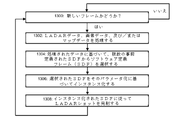
図7のシーケンスは、動き経路に影響を与える可能性のある障害物をステップ702で検出するインテリジェントセンサのスケジューラ600から始まる。インテリジェントセンサは、潜在的ではあるが検証されていない危険が環境に存在するという喚起を提供するインテリジェントLADARシステム206などの広視野センサであり得る。センサがLADARシステム自体ではなく別の異種センサである場合、このプロセス200は、例示的な実施形態では2つのケースを取ることができる。
The sequence of FIG. 7 begins with
第1のケースは、「選択的な検知」と呼ぶことができるものであり、それによって、スケジューラ600は、上述された直接プロービングのケースのように、LADAR源402を方向付ける。この例では、LADARシステム206は、センサがカメラなどのようなもの(赤外線または視覚センサ)である場合に、射程、速度、または単により良好な照明などのより詳細な情報を得るために使用される。上記では、物体が識別されたと想定して、当該物体に関する知識を向上させるためにLADARシステムを利用している。言い換えれば、喚起に基づいて、LADARシステムが物体に関する追加情報を返すための検知ショットが選択される。スケジューリングの別の実施形態である「比較」検知では、状況はよりニュアンスのあるものとなる。比較検知では、物体の有無は、LADARデータおよびビデオ物体が得られた後にのみ推論される。これは、ビデオ内の変化が、任意の1つの物体に関連付けられている場合と関連付けられていない場合とがあるためである。光の揺らぎは、様々な距離にある様々な静止した物体(例えば、非脅威)に起因しているか、または通過する動物の毛(例えば、脅威)からの反射などのものに起因している可能性がある。例えば、画像のフレーム間の変化は、迅速に動きを示すが、動きは画像をぼかし、したがって、移動する物体の形態および形状を評価することを困難にする。LADARシステム206は、受動画像センサを補完することができる。さらなるセンシングのためにぼやけエリアを選択することにより、LADARシステム206は、鮮明な3次元画像をプロービングして判定することができる。これは、画像は、約10Hz程度の動きに対してぼやけてしまうが、LADARシステム206は、数百ナノ秒以内にシーン全体をサンプリングすることができ、そのため、ぼやけないためである。比較は、LADAR戻りがぼやけ領域または静的背景に対応するかどうかを評価するために、LADAR後の画像形成に実施することができる。
The first case can be referred to as "selective sensing," whereby
別の例として、2つのセンサ(LADARシステムとキューセンサなど)間の双方向フィードバックループは、相殺されたデータレビューと検証の固有の性質に基づいて、動作計画のために必要な情報を提供することができる。 As another example, a bi-directional feedback loop between two sensors (such as the LADAR system and the cue sensor) provides the necessary information for action planning, based on the inherent nature of offset data review and verification. be able to.
選択的および比較的な検知はまた、センサの自己喚起からも発生してもよい。選択検知の例として、以下について考える。物体の動きがLADARシステム206で検出され、次いで、LADARシステム(圧縮センシングなどを介してインテリジェント測距点機能を有する場合)は、物体をさらに特徴付けるためにLADARショットのサルボで物体/関心領域を囲むようにタスク付与を行うことができる。比較例として、以前のフレームで物体が検出された道路の部分を再訪することを考える。射程または強度の戻りが変化する場合(これは定義上、比較の行為である)、これは比較検知と呼ばれてもよい。いったん物体が検出されると、信頼性の高い割り込みが自動車テレマティクス制御サブシステムに提供される前に、「客観的」検知と呼ばれ得るより高い知覚層が必要とされる。LADARシステム206は、低レイテンシであるために、そのビームを喚起された物体に迅速にスルーさせられることが望ましい。これは、迅速な走査を必要とする(その例は、方位角走査ミラー602および仰角走査ミラー604のジンバリングされた対として図6A~図6Cに示されている)。2次元光学フェーズドアレイLADARも同様に使用することができ、ジンバルは、微小機械走査ミラーの任意の方法で置き換えることができる。機械的走査であるMEMSシステムの例は、Boulder Nonlinear SystemsおよびBeamcoによって提供されているような液晶を使用した空間光変調器である。
Selective and comparative sensing may also occur from sensor self-awakening. As an example of choice detection, consider the following. Object motion is detected by the
図7に戻ると、ステップ700は、後続のセンサ解釈を用いて、潜在的な脅威を検出する。解釈は、道路の側面から道路への突然の動き(例えば、木の枝(無害)またはLADAR搭載車の前に飛び出す鹿(脅威))であり得る。ここでは、変化検出から動きを検知する簡単なビデオ活用が使用されてもよく、利用可能なアルゴリズムの選択肢は膨大であり、オープンCVなどのオープンソースプロジェクトが主流である。数多くのベンダーが、毎秒100フレーム以上を処理できる100万画素を超える高解像度カメラを販売している。わずか数フレームで、車両の計画された経路に沿ったまとまった動きを検出することができるので、喚起は非常に高速に発生し得る。第1のベクトル割り込み702は、LADARシステム206自体に対するものであってもよい。この例示的な実施形態では、ステップ700においてセンサによって観測された物体を抽出する要求で、LADARスケジューラ704が割り込まれ、オーバーライドされる(ステップ706)。この例では、レーザーは照準されていると想定される。視差がないことにより、カメラからレーザーへ座標を迅速に転送することができる。次に、必要に応じて、スキャナ602および604にコマンドが発行され、スキャナ602および604によって実行され、関心のある項目に向けてレーザーを発射するように方向付ける(ステップ708)。次いで、(例えば、LADAR送信機302によって)一組のLADARショットが発射され(ステップ710)、(例えば、LADAR受信機304によって)戻りパルスが光検出器内で収集され(ステップ712)て解析される。レイテンシをさらに低減するために、(例えば、マルチプレクサ504を介して)受信された焦点面の所望のセルのみが抽出される(ステップ714)。これにより、LADARデータを光学検出器からデジタルメモリに渡して解析する際の読み取り時間が合理化される。LADARシステム206自体が元の喚起源である場合、これは、1つのセンサが別のセンサを喚起する交差喚起とは対照的に、自己喚起と呼ぶことができる。
Returning to FIG. 7, step 700 detects potential threats with subsequent sensor interpretation. An interpretation could be a sudden movement from the side of the road onto the road, such as a tree branch (harmless) or a deer jumping in front of the LADAR-equipped vehicle (threat). Simple video exploitation from change detection to motion detection may be used here, and the choice of algorithms available is vast, dominated by open source projects such as OpenCV. A number of vendors sell high resolution cameras with over 1 million pixels capable of processing 100 frames per second or more. Arousal can occur very quickly, since in just a few frames it is possible to detect mass motion along the planned path of the vehicle. A first vectored interrupt 702 may be to the
次に、単一の測距点パルス戻り(716参照)がデジタル化され、ステップ718において解析されて、ピーク、最初の戻り、および最後の戻りが判定される。この操作は、点群352を活用して、先行する1つ以上の測距点パルス戻りも考慮することができる。このプロセスは、候補の脅威物体が、ベクトル割り込み決定を行うのに十分な忠実度で抽出されるまで、必要に応じて繰り返される。割り込み720が必要であるとみなされるならば、動作計画システム202が通知され、その結果、動作計画システム202のパイプライン化キュー722が割り込まれ、新しい経路計画(および関連する必要な動き)がスタックの先頭に挿入され得る(ステップ724)。
A single ranging point pulse return (see 716) is then digitized and analyzed in
100mを本発明者らのシナリオのための公称基準点としてとると、ステップ710でのパルスの発射から射程プロファイル(716を参照)の完了までに必要な時間は、以下のようになるので、約600ナノ秒である。

図7の下の部分は、本明細書に開示された例示的な実施形態および従来のラスタ走査システムの大まかに類似した段階に関して、このプロセスの各段階の予想される比較タイミングおよび距離(累積的)を示している。その違いは顕著であり、本発明の例示的な実施形態では、従来のシステムの68フィートに対して、障害物の動きが1フィート未満である必要があることが予想される。図7のこの部分は、レイテンシの支配的な発生源である段階を示す星印を含む。 The bottom portion of FIG. 7 shows the expected comparative timing and distance (cumulative ). The difference is significant, and it is anticipated that the exemplary embodiment of the present invention will require less than 1 foot of obstacle movement, as opposed to 68 feet for conventional systems. This portion of FIG. 7 includes asterisks to indicate stages that are the dominant sources of latency.
図7の処理チェーンの各段階でのレイテンシの節約の原因を探ることは有益である。 It is useful to explore the causes of latency savings at each stage of the processing chain of FIG.
センサ処理チェーンにおけるレイテンシの最初の段階は、喚起するセンサが脅威アイテムからの生の波面を受信したときから、LADARシステムコントローラが、LADAR送信機がこの脅威アイテムに対処するために指すべき方向を判定するまでの時間である。脅威を検出するためには喚起するセンサからの複数のフレームが必要となることが予想されるため、ここでの時間レイテンシは喚起するセンサのフレーム時間に支配される。従来、これには公称20Hzの更新レートが必要とされていたが、高速フレームビデオでは、衝突の可能性がある領域に重点を置いて100Hzに短縮することができる。例えば、45度の走査体積では、衝突評価のために約30%の画素検査しか必要ないと予想されている。現在利用可能な組み込みプロセッサは 、100GOPs の射程(毎秒数十億回の演算)で動作するため、異常検出のための画像解析段階は、実行時間をカウントする際に無視することができ、このためカメラの収集時間が支配的になる。 The first stage of latency in the sensor processing chain is when the arousing sensor receives the raw wavefront from the threat item, and the LADAR system controller determines the direction the LADAR transmitter should point to address this threat item. It is time to The time latency here is dominated by the frame time of the arousing sensor, since it is expected that multiple frames from the arousing sensor are required to detect a threat. Traditionally, this has required a nominal 20 Hz update rate, which can be reduced to 100 Hz for fast frame video with emphasis on areas of potential collision. For example, in a 45 degree scan volume, it is expected that only about 30% pixel inspection will be required for collision evaluation. Since currently available embedded processors operate at ranges of 100 GOPs (billions of operations per second), the image analysis stage for anomaly detection can be neglected when counting the execution time, hence Camera acquisition time becomes dominant.
かなりのレイテンシの次の段階は、割り込みを通じて(例えば、高速経路LADARショットのタスク再付与を介して)LADARショットをスケジュールすることである。スケジューリングスタックの最上部に新しいショットを配置する際のレイテンシは、レーザー402の最小空間反復率によって支配される。空間反復は、シーン内のスポットを再訪するのに必要な最小時間によって規定される。現在の従来の走査LADARシステムの場合、このタイムラインは10Hz程度、つまり100ミリ秒周期である。インテリジェント測距点の場合、例えば、圧縮センシングでLADARを走査する場合、最小空間反復率は走査速度によって決まる。これは、MEMSデバイスの機械的スルーレート(または熱制御された電気走査の同等の機械的ヒステリシス)によって制限される。5KHzは、必要なタイムラインのかなり控えめな推定である。この段階により、本発明の例示的な実施形態による1フィート未満の予想される追加の距離と比較して、従来のアプローチでは、物体が約13フィートの追加の距離を移動すると予想される。次のステップは、LADAR送信機へのコマンド、およびレーザーが発射するためのセットアップ時間の実行を計算することである。この時間は小さく、従来の方法と本発明の方法との両方に匹敵するものであり、100KHz程度であると本発明者らは考える。これは、ほとんどの自動車用LADARシステムの発射時間に対応している。
The next step in significant latency is scheduling LADAR shots through interrupts (eg, via retasking of fast-path LADAR shots). The latency in placing a new shot at the top of the scheduling stack is governed by the minimum spatial repetition rate of
動作計画センサパイプラインにおけるかなりのレイテンシの次の段階は、LADARパルスの発射および戻りの収集である。飛行時間はごくわずかなので(前述の解析では約600ナノ秒)、この段階はショット間の所要時間によって時間的に支配される。LADARレポートの信頼性を高めるには、複数の観測が必要になることが予想されるため、この段階は支配的になる可能性がある。実際、10Hzの空間再訪を行う現在のレーザーの場合、5ショット(安全な割り込みのための確実な使用に必要な最小ショット数であると予想される)1/2秒のレイテンシになる。専用の注視が可能なレーザーを用いると、レーザーの再発射速度内で5ショットを発射することができる(約200マイクロ秒の再発射時間を控えめな数値として使用することができる場合)。パルスが発射された後、活用前の追加のレイテンシはわずかであり、LADAR戻りのメモリページングによって支配される。正確なタイミングは実施者が使用する電子機器に依存するが、現在のSDRAMの典型的な量は1マイクロ秒程度である。最後に、LADARおよびカメラの画像を動作計画部に割り込む決定(そうである場合、計画部に渡す情報)に変換するための活用段階が必要である。この段階は、インテリジェント測距点LADARシステムで非常に短くすることができる。従来のパイプライン化されたLADARシステムの場合、レイテンシは1つの固定フレーム程度、公称10Hzであると予想される。 The next stage of significant latency in the motion planning sensor pipeline is the collection of LADAR pulse firing and returning. Since the flight time is negligible (approximately 600 ns in the previous analysis), this phase is temporally dominated by the duration between shots. This stage can be dominant as it is expected that multiple observations will be required to increase the reliability of LADAR reports. In fact, for current lasers with 10 Hz spatial revisiting, this results in 5 shots (which is expected to be the minimum number of shots required for reliable use for safe interrupts) of 1/2 second latency. With a dedicated gaze enabled laser, 5 shots can be fired within the refire rate of the laser (if a refire time of approximately 200 microseconds can be used as a conservative number). After the pulse is fired, the additional latency before exploitation is negligible and dominated by memory paging of LADAR returns. The exact timing depends on the electronics used by the implementer, but a typical amount for current SDRAM is on the order of 1 microsecond. Finally, an exploitation step is required to convert the LADAR and camera images into decisions (and, if so, information to pass to the planner) that interrupt the motion planner. This stage can be very short with an intelligent ranging point LADAR system. For a conventional pipelined LADAR system, latency is expected to be on the order of one fixed frame, nominally 10 Hz.
最後に、干渉は、レーダーおよび他の能動的なイメージャ(例えば、超音波)と同様に、LADARシステムにおけるレイテンシの原因となる。その理由は、データマイニング、機械学習、および推論が、そのようなノイズをフェレットアウトするために使用できるからである。低レイテンシを達成するために、動作計画は、ストライド干渉の低減で使用することができる。そのような方法の1つは、2017年2月17日に出願され、「Method and System for Ladar Pulse Deconfliction」と題された米国特許出願第62/460,520号に開示されているようなパルス符号化の使用であり、その開示の全体が参照により本明細書に組み込まれる。追加の方法が次に提案される。散発的な干渉の1つの原因は、強い戻りからの「独自の」LADARシステム誘発の飽和、または他のLADARシステムの飽和のいずれかに起因する受信機の飽和である。このような飽和は、LADAR受信機の光検出回路の増幅器に電流スパイクが入るのを防ぐ保護回路を用いて克服することができる。そのような保護回路は、感度と飽和からのレイテンシとを交換したいという実施者の要望に応じて、製造中に選択的に追加または破棄することができるというよりも、メタライゼーション層として製造することができる。このような保護回路は、次のように動作するように設計することができる:電流スパイクがある値を超えると、フィードバック回路が出力をチョークする。これにより、感度が低下する(例えば、ノイズ等価電力が増加する)代わりに、フォトダイオードが保護される。図9は、(例えば)第1のトランスインピーダンス増幅器の出力における電圧910を超えると、ダイオード920が起動するように保護ダイオード920が使用される、このような保護回路の例示的な実施形態を示している。ダイオード920が起動されると、電流が流れ、エネルギーが後続の検出回路930から迂回される。 Finally, interference contributes to latency in LADAR systems, as well as radar and other active imagers (eg, ultrasound). The reason is that data mining, machine learning, and inference can be used to ferret out such noise. To achieve low latency, motion planning can be used with stride interference reduction. One such method is a pulsed pulse as disclosed in U.S. patent application Ser. The use of encoding, the entire disclosure of which is incorporated herein by reference. An additional method is then proposed. One source of sporadic interference is receiver saturation, either due to "unique" LADAR system-induced saturation from strong returns, or saturation of other LADAR systems. Such saturation can be overcome with a protection circuit that prevents current spikes from entering the amplifiers of the LADAR receiver's photodetector circuits. Such protection circuitry can be fabricated as a metallization layer rather than being selectively added or discarded during fabrication, depending on the desire of the implementer to trade sensitivity for latency from saturation. can be done. Such a protection circuit can be designed to operate as follows: when the current spike exceeds a certain value, the feedback circuit chokes the output. This protects the photodiode at the cost of reduced sensitivity (eg, increased noise equivalent power). FIG. 9 shows an exemplary embodiment of such a protection circuit in which a protection diode 920 is used such that when the voltage 910 at the output of (for example) the first transimpedance amplifier is exceeded, the diode 920 is activated. ing. When the diode 920 is activated, current flows and energy is diverted from the subsequent detection circuit 930 .
図8は、様々な種類の脅威の協働検出のための例示的な処理フローを開示している。図8の異なる列は、インテリジェントセンサに組み込まれた脅威検出インテリジェンスによって検出され得る脅威の異なるタイプを示している。この例では、検出され得る脅威のタイプは、「脱線」800、「揺らぎ」810、および「光沢のある物体」820が含まれる。これらの脅威のタイプは例示に過ぎず、実施者が所望する場合、脅威検出インテリジェンスはまた、異なるおよび/または追加の脅威を検出するように構成され得ることが理解されるべきである。 FIG. 8 discloses an exemplary process flow for collaborative detection of various types of threats. Different columns in FIG. 8 represent different types of threats that can be detected by the threat detection intelligence embedded in the intelligent sensors. In this example, types of threats that may be detected include 'derailment' 800 , 'jitter' 810 , and 'shiny object' 820 . It should be appreciated that these types of threats are exemplary only, and that threat detection intelligence can also be configured to detect different and/or additional threats if desired by the practitioner.
図8の行は、システムのどの要素または段階が、協働モデルの様々な操作を実施するために使用され得るかを示している。第1の行は、センサ喚起操作に対応する。第2の行は、LADARシステムまたは他のセンサインテリジェンス(カメラインテリジェンスなど)による点群活用に対応する。一般的に、点群活用のための信号処理はFPGAまたはカスタムプロセッサで実行され、処理ではなくセンサ収集時間が制限要因となるレベルまでレイテンシを抑えることができる。第3の行は、動作計画システム202によって実施される割り込み動作に対応する。 The rows of FIG. 8 indicate which elements or stages of the system can be used to implement various operations of the collaboration model. The first row corresponds to sensor wake-up operations. The second row corresponds to point cloud exploitation by LADAR systems or other sensor intelligence (such as camera intelligence). Typically, signal processing for point cloud exploitation is performed in FPGAs or custom processors, allowing latency to be reduced to a level where sensor acquisition time rather than processing becomes the limiting factor. The third row corresponds to interrupt actions performed by action planning system 202 .
LADAR自己喚起802は、脱線事象を検出するために使用することができる。脱線脅威の検出では、LADARシステムは、LADAR搭載車両の車線内の進入車両および/または進入車両が不規則に移動していることを示すLADARフレームデータを得る。LADARシステムは、関心領域を横断するラスタ走査を使用することができる。この関心領域は、例えば、水平線で見た、LADAR搭載車両が中心にある道路であってもよく、ここで、最初に進入車両が検出される。この場合、走査から走査までの間に不規則な行動を示す車両が存在する可能性がある。これは、(i)車両が、検出される方位角ビームの変化によって証明されるように、車線から脱線したり戻ったりしている、(ii)車両が、おそらく別の車両を追い越しているために、誤った車線から接近してきている、あるいは(iii)車両が、安全であることが保証されている道路状態および標識などの速度を大幅に上回るかまたは下回る速度で移動している可能性がある。これらの3つの状態はすべて、データの1つのまたは数フレームの中で識別することができる(ステップ804を参照)。 LADAR self-awakening 802 can be used to detect derailment events. In derailment threat detection, the LADAR system obtains LADAR frame data that indicates that the ingress vehicle and/or the ingress vehicle is moving erratically within the lane of the LADAR-equipped vehicle. LADAR systems can use raster scanning across a region of interest. This region of interest may be, for example, the road centered by the LADAR-equipped vehicle, viewed at the horizon, where the incoming vehicle is first detected. In this case, there may be vehicles exhibiting erratic behavior between scans. This is because (i) the vehicle is derailing and returning from the lane, as evidenced by changes in the detected azimuth beam, and (ii) the vehicle is possibly passing another vehicle. or (iii) the vehicle may be traveling significantly above or below speeds such as road conditions and signs that are guaranteed to be safe. be. All three of these states can be identified within one or a few frames of data (see step 804).
ステップ804において、点群352は、フレームデータ220を介して日常的に更新され、動作計画システム202に報知される。背景モードでは、LADARシステム206内の脅威検出インテリジェンス(例えば、FPGA)が、領域内の個別の物体を追跡する。非線形射程レートまたは角度レートは、物体の追跡が不規則であるか、または車線変更を示すかどうかを明らかにすることができる。物体の動きが脅威的であるとみなされる場合、割り込みを動作計画部に発行することができる(例えば、優先フラグ250を介して)。
At
ステップ806において、動作計画部は、検出された脱線状態(例えば、正面衝突の脅威または単に対向車両間衝突の脅威)に起因する危険となる進入交通があることを、割り込みを介して通知される。
At
「揺らぎ」検出810のための例示的な処理フローは、ステップ812によって示されるように、別のセンサからの交差喚起を含むことができる。ここでは、LADAR搭載車両の経路に沿って、カメラ画素のクラスタで変化が検出される実施形態が示されている。この変化は、車が森林エリアを走行している場合には、葉が揺らいでいることに起因する場合があり、または鹿が道路に飛び込んできたことに起因する場合がある。このようなカメラの検出は、次いで、LADARシステムを喚起して追加のプロービングを行うために使用することができる。 An exemplary process flow for “wobble” detection 810 may include cross-excitation from another sensor, as indicated by step 812 . Here, an embodiment is shown in which changes are detected in clusters of camera pixels along the path of the LADAR-equipped vehicle. This change may be due to waving leaves if the car is driving in a forest area, or due to a deer running into the road. Such camera detection can then be used to awaken the LADAR system for additional probing.
LADARシステムは、ステップ814において2ショット以内の動きを検知することができ、数ショットで移動する物体のサイズを決定することもできる。このような学習は、受動カメラだけでは、はるかに長い時間がかかる。したがって、カメラが揺らぎを示す変化を検出すると、これは、揺らぎ領域に向けてLADARショットを目標に設定にするために、LADARシステムを喚起することができる。LADAR戻りを処理するインテリジェンスは、ブロブ動きモデルを作成することができ、これらのブロブ動きモデルは、動作計画の割り込みが必要かどうかを判定するために解析することができる。
The LADAR system can detect motion within two shots at
ステップ816において、動作計画部は、障害物(前の点群フレームからは存在しなかった可能性がある)があること、およびこの障害物が車両との衝突コース上にあり得る場所がどこにあるかを、割り込みを介して通知される。
In
脅威検出処理フローの第3の例は、光沢のある物体820についてのものであり、これは、別の交差喚起の例であり得る(822を参照)。ステップ824において、物体が最近の既存のフレームに存在しない色を有する、単一のカメラフレームで観測される。これは、自然の秩序から得られた可能性が低いとみなされ、したがって、人間の人工物であると推定される。このような色の変化は、点群のカラーヒストグラムでフラグを立てることができる。タスクが付与されたLADARショットは、この物体の位置を迅速に判定し、それが小さな破片であるか、または移動する、潜在的に脅威となる物体の一部であるかを、車両の動き経路と比較することを介して判定することができる。色変化物体が脅威的であるとみなされる場合には、割り込みを発行することができる(その後、ステップ816を実施することができる)。
A third example of a threat detection process flow is for shiny objects 820, which may be another example of cross evocation (see 822). At
図8の例では、計算の複雑さは、低い(ショットあたり数十回程度の演算である)ことが予想され、これは、本発明者らが低レイテンシソリューションに適していると考えている。 In the example of FIG. 8, the computational complexity is expected to be low (on the order of tens of operations per shot), which we believe is suitable for low-latency solutions.
図10A~図10Dの例は、カメラをLADAR受信機と共に照準させることによって、LADARデータが処理されるレイテンシをどのように改善できるかを示している。従来のレーザーシステムでは、カメラはレーザーシステムの外部に位置付けられている。この配置では、カメラ画像をレーザーに再整列させるために、計算量の多い(したがって、レイテンシを誘発する)作業が必要となる。外部カメラを有する従来のレーザーシステムのこの再整列プロセスは、視差除去として知られている。このような視差除去タスクを回避するために、図10A~図10Dは、カメラおよびLADAR受信機が共通の光学エンジンの一部である例示的な実施形態を説明する。例えば、図10A~図10Cは、カメラ1002がLADAR受信機の光検出器500と共に照準されている例を示す。カメラ1002はビデオカメラであってもよいが、これに限定される必要はない。図10A~図10Cの例は、カメラ1002が共に照準されていることを除いて、図6A~図6Cの例と類似している。
The examples of FIGS. 10A-10D show how aiming a camera together with a LADAR receiver can improve the latency with which LADAR data is processed. In conventional laser systems, the camera is positioned outside the laser system. This arrangement requires computationally intensive (and thus latency-inducing) work to realign the camera image to the laser. This realignment process for conventional laser systems with external cameras is known as parallax removal. To avoid such de-parallax tasks, FIGS. 10A-10D describe exemplary embodiments in which the camera and LADAR receiver are part of a common optical engine. For example, FIGS. 10A-10C show an example in which the
レンズ610は、受信機を外部環境から分離し、可視光とレーザー帯域光との両方を受信するように構成されている。共に照準されることを達成するために、光学システムは、レンズ610と光検出器500との間に光学的に位置付けられるミラー1000、およびレンズ610とカメラ1002との間に光学的に位置付けられるミラー1000を含む。ミラー1000、光検出器500、およびカメラ1002は、通常、統合されたLADARシステムの一部として同じエンクロージャまたはハウジング内に収容することができる。ミラー1000は、その反射特性が入射光の周波数または波長に基づいて変化するように、ダイクロイックミラーであり得る。例示的な実施形態では、ダイクロイックミラー1000は、(1)第1の光スペクトル(例えば、可視光スペクトル、赤外(IR)光スペクトルなど)のレンズ610からの入射光を、経路1004を介してカメラ1002に方向付け、かつ(2)第2の光スペクトル(例えば、LADARパルス反射を含むレーザー光スペクトル)のレンズ610からの入射光を、経路1006を介して光検出器500に方向付けるように構成されている。例えば、ミラー1000は、第1の光スペクトルの光をカメラ1002に向けて反射し(経路1004を参照)、第2の光スペクトルの光を光検出器500に向けて通過させることができる(パス1006を参照)。光検出器500およびカメラ1002は、共に照準されることに起因して同じ視野を共有するため、これにより、特に立体視システムにおいて、カメラ1002からの画像データと光検出器500から導出された測距点データとの融合が大幅に合理化される。すなわち、カメラ1002からの画像データは、当技術分野の従来のシステムによって必要とされる計算集約的な視差除去タスクを必要とせずに、光検出器500から導出された計算された測距点データと空間的に整列することができる。例えば、典型的な高フレームレートの立体ビデオストリームは、位置合わせ誤差による視力の損失にもかかわらず、ビデオをLADARデータに整列するために、数十ギガフロップスもの処理を必要とする。これらは、共に照準されるカメラ1002を使用することで回避することができる。ビデオおよびLADARの位置合わせにギガフロップスの処理を使用する代わりに、共に照準されるカメラを使用することで、より複雑ではない技術を使用して整列することができる。例えば、工場の組み立てステーションで較正する場合、LADARシステムおよびカメラを使用してチェックボードパターンの画像を取り込むことができる。次いで、カメラ画像とLADAR画像との間に不整合があるかどうかを観測し、読み出しコードの整列をハードワイヤリングすることによって不整合を除去することができる。商用グレードのLADARシステムおよびカメラでは、これらの不整合はまばらになると予想される。例えば、カメラとLADARシステムとの両方が100×100画素のx-y画素グリッドを有しているとする。次いで、LADARシステムとカメラとの両方が100×100の白黒チェッカーボードに対して画像を表示する。この例では、カメラ画像の右上隅の画素100、100がグリッドから外れていることを除いて、すべての画素が一直線に並んでおり、カメラ画像の画素99、100がチェックボードのエッジにあるが、LADAR画像は、角部を指している画素99、100および100、100の両方を有する。次いで、整列は単純に以下のようになる:
1) xおよびyのカメラ画素をそれぞれiおよびj、射程をi、j=1、.....、100、LADARをk、l、射程を同様にk、l=1、.....、100と規定する。
1) Let x and y camera pixels be i and j respectively, range i, j=1, . . . . . , 100, LADAR k, l, range similarly k, l=1, . . . . . , 100.
2) カメラ画像との画素位置合わせに基づいて、LADARをインデックス化(融合/整列)する。例えば、カメラ画素、例えば12、23を検査するとする。ここで本発明者らは同様に、その対応するLADAR画素を検査するとする。そのために、システムは、LADARデータの画素12、23を呼び戻す(例えば、メモリからフェッチする)。上記の例に関して、カメラ画素が99、100または100、100以外の任意の画素である場合、呼び戻されたLADAR画素はカメラ画素と同じであり、本発明者らは、カメラの画素99、100にアクセスしている場合、LADAR画像の画素99、100および100、100の集合を選択し、カメラ画像が画素100、100にある場合、LADAR画像にはアクセスしない。 2) Index (merge/align) the LADAR based on pixel registration with the camera image. For example, suppose camera pixels, say 12, 23, are to be inspected. Now let us likewise examine its corresponding LADAR pixel. To do so, the system recalls (eg, fetches from memory) pixels 12, 23 of the LADAR data. For the above example, if the camera pixel is 99,100 or any pixel other than 100,100, then the recalled LADAR pixel is the same as the camera pixel, and we assume that the camera pixel 99,100 If so, select the set of pixels 99,100 and 100,100 of the LADAR image, and if the camera image is at pixel 100,100, do not access the LADAR image.
3) LADARで喚起されるカメラについても、逆方向ではあるが、同様の方向に繰り返す。 3) Repeat in a similar but opposite direction for the LADAR-evoked cameras.
この整列を実施するために複雑な演算は必要ないことに留意されたい。その代わりに、各データ照会に必要なのは単純で小さな論理テーブルだけであり、典型的には数キロバイトである。対照的に、共に照準されない整列には多くのGバイトが必要である。 Note that no complex operations are required to perform this alignment. Instead, each data query requires only a simple, small logical table, typically several kilobytes. In contrast, non-both aligned alignments require many Gbytes.
図10Dは、共に照準されるカメラ1002がシステムでどのように有利に使用され得るかを示す例示的な処理フローを示している。ステップ1050において、光が受信される。この受信された光は、上述されたように、1つ以上のLADARパルス反射を含むことができる。ステップ1050は、レンズ610によって実施することができる。ステップ1052において、第1の光スペクトルの受信光の部分は、カメラ1002に向けて方向付けられ、第2の光スペクトルの受信光の部分は、光検出器500に向けて方向付けられる。上述されたように、第2の光スペクトルは、LADARパルスおよびLADARパルス反射のスペクトルを包含する。このステップは、ミラー1000によって実施することができる。
FIG. 10D illustrates an exemplary process flow showing how
ステップ1054において、光検出器1054は、ミラー1000によって光検出器1054に向けられたLADARパルス反射を検出する。ステップ1056において、検出されたLADARパルス反射に基づいて測距点データが計算される。ステップ1056は、上述されたような信号処理回路およびプロセッサを使用して実施することができる。
At step 1054 , photodetector 1054 detects the LADAR pulse reflection directed to photodetector 1054 by
一方、ステップ1058において、カメラ1002は、ミラー1000によってカメラ1002に向けられた光に基づいて画像データを生成する。その後、プロセッサは、ステップ1056からの計算された測距点データを、ステップ1058からの画像データと空間的に整列することができる(ステップ1060を参照)。次に、LADARシステムおよび/または動作計画システムは、空間的に整列された測距点データおよび画像データに基づいて、LADAR目標設定および/または車両の動きに関する決定を行うことができる。例えば、図10B~図10Cによって示されるように、この意思決定は、ショットリスト400における新しいショットの挿入をもたらすことができる。さらにまた、動作計画システム202は、空間的に整列された測距点および画像データの内容に基づいて、何らかの方法で車両の動きを変更することを選択することができる。
Meanwhile, at step 1058 ,
図10A~図10Cは例示的な実施形態を示しており、実施者は、システムにさらなる光学素子を含めることを選択してもよいことが理解されるべきである。例えば、ミラー1000による分割後の光路、例えば、ミラー1000とカメラ1002との間の光路1004、および/またはミラー1000と光検出器500との間の光路1006に、追加の光学素子が含まれてもよい。さらに、カメラ1002の波長は、可視色スペクトル、グレースケールスペクトル、受動IRスペクトル、ハイパースペクトルスペクトル、ズーム倍率の有無などであってもよい。また、LADARシステムの焦点面は、能動(LADAR)焦点面と受動(ビデオ)焦点面の組み合わせとして機能するのに十分な受容波長を有してもよい。
It should be appreciated that FIGS. 10A-10C illustrate exemplary embodiments and that the practitioner may choose to include additional optical elements in the system. For example, the optical path after splitting by
レイテンシ低減の別の利点は、LADARデータの単一フレーム内のデータに基づいて物体に関する動きデータを計算する能力である。例えば、(3D)速度および加速度の真の推定値は、LADARショットの単一フレーム内のLADARデータから計算することができる。これは、ファイバまたはダイオードLADARシステムに関連付けられている短いパルス持続時間に起因するものであり、短いタイムライン内での複数の目標測定を可能にする。速度推定により、動きのない物体(LADAR搭載車両が動いている場合は閉速度を有する)を除去することができる。また、速度推定は、検出が発生した後に追跡が開始されたときに存在するノイズの量を減少することもできる。例えば、速度がない場合、100mで10mradのビームでは、3mの射程関連付けウィンドウが必要となるが、これは3nsのパルスでは18個のx、y分解能のノイズ暴露ビン(パルス幅から1/2m、ビーム発散から1m)に相当する。対照的に、3mの関連付けに加えて、両方の次元で3m/sの速度フィルタがある場合、公称10Hzのフレームレートでは、ノイズ曝露の範囲は約2~4ビンに減少する。フレーム内ベースで物体に関する動きデータを計算する能力により、物体の堅牢な運動学的モデルを低レイテンシで作成することができる。 Another advantage of latency reduction is the ability to compute motion data for an object based on data within a single frame of LADAR data. For example, true estimates of (3D) velocity and acceleration can be computed from the LADAR data within a single frame of the LADAR shot. This is due to the short pulse durations associated with fiber or diode LADAR systems, allowing multiple target measurements within a short timeline. Velocity estimation allows the removal of non-moving objects (which have closed velocity if the LADAR-equipped vehicle is moving). Velocity estimation can also reduce the amount of noise present when tracking begins after detection has occurred. For example, in the absence of velocity, a 10 mrad beam at 100 m would require a range association window of 3 m, which for a 3 ns pulse would require 18 x,y resolution noise exposure bins (1/2 m from pulse width, 1 m) from the beam divergence. In contrast, with a 3m correlation plus a velocity filter of 3m/s in both dimensions, the range of noise exposure is reduced to about 2-4 bins at a nominal 10Hz frame rate. The ability to compute motion data about an object on an intra-frame basis allows the creation of robust kinematic models of objects with low latency.
図11Aは、例示的な実施形態に従ってフレーム内の動きデータを計算するための例示的な処理フローを示す。ステップ1100において、LADAR送信機302は、単一のLADARフレーム内の目標に、重複するLADARパルスショットのクラスタを発射する。クラスタ内のLADARパルスは、短い持続時間(例えば、MEMS走査ミラーがLADARシステムによって使用される実施形態では、典型的なMEMS共振速度では、約5マイクロ秒~約80マイクロ秒)にわたって時間的に離間している。ビームクラスタは、方位角、仰角、および射程のすべての3次元において重複を提供することができる。これは、各LADARパルスがパルスの飛行時間にわたって光の円錐を切り出すことに注目することによって可視化することができる。いずれの時点でも、ミラーの位置から、この円錐が空間のどこに位置付けられるかを計算することができます。この情報は、スケジューラでパルスのショット時間を選択するために使用されて、すべての3次元での重複を確実にすることができる。この重複は、シーンに関する情報を抽出するために、異なるルックアングル(視差)を効果的に使用することによって、シーンに関する独自の情報源を提供する。
FIG. 11A shows an exemplary processing flow for computing intra-frame motion data in accordance with an exemplary embodiment. At step 1100,
動き推定に対するこのクラスタ化アプローチのレイテンシの利点は、上記で参照されて組み込まれた特許および特許出願に記載されているような圧縮センシングを使用する動的LADARシステムと組み合わせて使用される場合には、さらに拡大され得る。このような動的LADARシステムでは、LADARコントローラは、パルスごと(すなわち、ショットごと)にLADAR送信に影響を及ぼす。これとは対照的に、従来のLADARシステムは、ショットパターンが繰り返されるときに開始および停止を行う固定フレームを規定している。つまり、フレーム内のショットパターンはフレームの開始時に固定されており、フレーム内で動的に適応されることはない。圧縮センシングを使用した動的LADARシステムでは、ショットパターンはフレーム内で動的に変化し得(すなわち、フレーム内ダイナミズム)、すなわち、i番目のショットのショットパターンは、ショットi-1の直接の結果によって異なり得る。 The latency advantage of this clustering approach to motion estimation, when used in combination with dynamic LADAR systems using compressed sensing as described in the above-referenced and incorporated patents and patent applications, is , can be further expanded. In such a dynamic LADAR system, the LADAR controller influences the LADAR transmission on a pulse-by-pulse (ie, shot-by-shot) basis. In contrast, conventional LADAR systems define fixed frames that start and stop when the shot pattern repeats. That is, the shot pattern within a frame is fixed at the start of the frame and is not dynamically adapted within the frame. In a dynamic LADAR system using compressed sensing, the shot pattern can change dynamically within a frame (i.e., intra-frame dynamism), i.e., the shot pattern of the i-th shot is a direct result of shot i−1. can vary depending on
典型的な固定フレームLADARシステムは、FOVによって規定されるフレームを有し、FOVは、ショットからショットへと走査され、FOVが完全に抽出されると、プロセスが繰り返される。したがって、圧縮センシングを使用する動的LADARシステムのショット選択を適応させる能力はマイクロ秒で測定されるが、従来の固定フレームLADARシステムのショット選択を適応させる能力は数百ミリ秒または100,000倍遅く測定される。このように、動きデータを推定するのに役立つフレーム内LADARパルスの動的に選択されたタイトなクラスタを使用する能力は、物体の動き推定に関してレイテンシの大幅な改善をもたらすことが期待される。 A typical fixed-frame LADAR system has a frame defined by a FOV, which is scanned from shot to shot, and the process is repeated once the FOV is fully extracted. Thus, the ability to adapt shot selection of dynamic LADAR systems using compressed sensing is measured in microseconds, whereas the ability to adapt shot selection of conventional fixed-frame LADAR systems is measured in hundreds of milliseconds or 100,000 times. measured late. Thus, the ability to use dynamically selected tight clusters of intra-frame LADAR pulses to help estimate motion data is expected to provide significant latency improvements for object motion estimation.
一方で、図11Aに戻ると、ステップ1102において、LADAR受信機304は、LADARパルスのクラスタからの反射戻りを受信および処理する。この処理の一部として、LADAR受信機304は、目標のフレーム内の動きデータを計算することができる。この動きデータは、タイトクラスタによって目標に設定された測距点からの反射戻りに対する射程および強度の変化に基づいて計算することができる。例えば、目標の速度および加速度は、これらの反射戻りに基づいて推定することができる。このような動きデータをフレーム内で計算することによって、視野内の1つ以上の目標の動きをモデル化する際のレイテンシを大幅に減少することができ、その結果、動作計画システムによるより高速な意思決定につながる。
Meanwhile, returning to FIG. 11A, at step 1102, the
図11Bは、図11Aのステップ1100および1102を実装するための例示的な処理フローを示す。図12Aは、図11Bに関して参照のためのLADARパルスビームの例示的なクラスタを示している。図11Bは、関心目標が検出されるステップ1110から始まる。目標検出を実施するために、いくつかの技法のいずれかを使用することができる。例えば、LADARデータおよび/またはビデオデータをステップ1110で処理して、目標を検出することができる。さらにまた、ソフトウェアで定義されたフレーム(その例は以下で説明される)を処理して、関心のある目標を検出することができる。例として、ステップ1110においてランダムフレームを選択することができ、目標は、その射程が高解像度マップからの固定点にマッピングされない戻りとして宣言することができる。しかしながら、目標検出のための他の技法が使用され得ることが理解されるべきである。 FIG. 11B shows an exemplary processing flow for implementing steps 1100 and 1102 of FIG. 11A. FIG. 12A shows an exemplary cluster of LADAR pulsed beams for reference with respect to FIG. 11B. FIG. 11B begins at step 1110 where a target of interest is detected. Any of several techniques can be used to perform target detection. For example, LADAR data and/or video data may be processed at step 1110 to detect targets. Furthermore, software-defined frames (examples of which are described below) can be processed to detect targets of interest. As an example, a random frame can be selected in step 1110 and the target can be declared as a return whose range is not mapped to a fixed point from the high resolution map. However, it should be understood that other techniques for target detection may be used.
ステップ1112において、検出された目標の座標は、互いに直交する2つの軸に関して規定することができる。参照を容易にするために、これらの座標は、XおよびYと呼ばれ得る。例示的な実施形態では、Xは、水平(方位角)軸に沿った座標を指すことができ、Yは、垂直(仰角)軸に沿った座標を指すことができる。 At step 1112, the coordinates of the detected target can be defined with respect to two mutually orthogonal axes. For ease of reference, these coordinates may be called X and Y. In an exemplary embodiment, X can refer to coordinates along the horizontal (azimuth) axis and Y can refer to coordinates along the vertical (elevation) axis.
ステップ1114において、LADAR送信機302は、LADARショットBおよびCを目標に発射し、ここで、LADARショットBおよびCは同じ水平座標Xを共有するが、LADARショットBおよびCが視野内の指定された距離で重複するビームを有するように、異なる垂直座標を有する。図12Aは、LADARショットBおよびCの考えられる配置の例を示している。ビームの半径は、光学系(発散)と目標までの射程との両方に依存することが理解されるべきである。
In step 1114,
ステップ1116において、LADAR受信機304は、LADARショットBおよびCからの反射戻りを受信および処理する。これらの反射戻りは、推定された目標仰角Ytを計算するために処理される。これを行うために、BおよびCからの戻りのショットエネルギーを比較することができる。例えば、2つの戻りのエネルギーが等しい場合、目標は、BとCとの中心間の線の中点に存在するとみなすことができる。B戻りのエネルギーがC戻りのエネルギーを超える場合、目標は、B戻りおよびC戻りのエネルギー比に対応する量だけこの中間点より上に存在するとみなすことができる(例えば、C戻りに比べてB戻りの対応するエネルギーが大きいほど、Bの中心に比例して近くなる)。C戻りのエネルギーがB戻りのエネルギーを超える場合、目標は、B戻りおよびC戻りのエネルギー比に対応する量だけ、この中間点よりも下に存在するとみなすことができる(例えば、B戻りに比べてC戻りの対応するエネルギーが大きいほど、Cの中心に比例して近くなる)。
At step 1116,
ステップ1118において、新しいLADARショットB´が、垂直座標Ytおよび水平座標Xの測距点を目標とするように規定される。次に、ステップ1120において、新しいLADARショットAが、垂直座標Ytおよび水平座標X’の測距点を目標に設定するように規定され、XとX´との間のオフセットは、交差射程目標位置の推定を可能にするのに十分に大きいが、B´またはAのいずれかで目標を見落とすのを避けるのに十分に小さい。すなわち、B’およびAのうちの少なくとも1つが検出された目標にヒットする。X´の選択は、LADARビーム発散と同様に、数学を使用して、特徴付けられる対象物までの距離および寸法に依存する。例えば、10mradのLADARビーム、100mの射程、1mの幅の車両(例えば、自動二輪車)を後方から見た場合、X´の値は、1/2メートルであるように規定することができる。 In step 1118, a new LADAR shot B' is defined to target the range point at vertical coordinate Yt and horizontal coordinate X. Next, in step 1120, a new LADAR shot A is defined to target a range point at vertical coordinate Yt and horizontal coordinate X', where the offset between X and X' is the cross-range target position is large enough to allow estimation of , but small enough to avoid missing targets in either B' or A. That is, at least one of B' and A hits the detected target. The choice of X', like LADAR beam divergence, depends on the distance and size of the object to be characterized using mathematics. For example, for a 10 mrad LADAR beam, 100 m range, 1 m wide vehicle (eg, motorcycle) viewed from behind, the value of X' can be specified to be 1/2 meter.
ステップ1122において、LADAR送信機302は、LADARショットB´およびAをそれぞれの目標に設定する測距点で発射する。次いで、LADAR受信機304は、B´およびAの反射戻りを受信して処理し、B´およびAの射程および強度データを計算する(ステップ1124)。具体的には、標準的なLADAR射程の式をとり、固定LADARシステムパラメータを入力し、測定された信号パルスエネルギーを達成するために必要な目標反射率を計算することによって、所望の反射値を得ることができる。射程は、飛行時間技法を使用して評価することができる。射程は、射程(B´)および射程(A)で表すことができる。強度は、強度(B´)および強度(A)で表すことができる。次いで、ステップ1126において、プロセッサは、射程(B´)、射程(A)、強度(B´)、および強度(A)に基づいて、目標の交差射程および射程重心を計算する。交差射程は、rで表される射程(飛行時間)、および方位角θ(発射時間およびミラー位置から)を計算し、極変換rsin(θ)を評価することによって求めることができる。I(i)は強度を表し、複数回の測定で射程重心は以下のように求められる:


図12Aは、図11Bに関して動作原理を説明するのに役立つ、LADARショットクラスタのための視野内の例示的なビームレイアウトを示す。図12Aによって示されているのは、目標が抽出されるビーム位置A、B、C(1200)である。これらのビームは、全幅の半分の最大値、すなわち1/e2レベルで重複している。説明の目的および教育上の実演のために、(i)有効な目標は、これらのビームA、B、およびCの結合内にあり、(ii)A、BおよびB、Cは同一平面上にあると想定される。この文脈では、3つのビームが同一平面上にあると規定されるのは、接続部のコリニアルック方向が直交するペアワイズの組み合わせが存在する場合である。図12Aでは、A、Bが水平方向に整列し、B、Cが垂直方向に整列するので、これが当てはまることが分かる。中心軸(位相中心)が一致している必要はないことに留意されたい。真の目標は、視野内の1201にある。上記のように、図11Bの処理フローは、ある時点での目標位置の精緻な推定値を得るために、方位角および仰角の補間を可能にすることができる。この精緻な推定値を中心とする(またはその近くにある)LADARビームは、A´(1202)と表すことができる。実際には、A´が1201を完全に中心とすることはほとんどなく、というのも、(i)ノイズに起因する重心で1201の真の値を近似しているだけであり、(ii)ソフトウェアは一般的に、常にではないにせよ、選択可能な位置の量子化されたセットに限定されるためである。ビームA´が作成されると、システムはまた、同一線上に重複するLADARビームB´およびC´も同様に作成することができる(図示を容易にするために図12Aには示されていない)。これらのビームを介して行われた抽出および解析の結果は、図12Bに示された速度テーブルとなる。この結果から、システムは、目標の射程および角度位置の正確な推定値を生成することができるが、説明の目的のためには、知識をビーム発散(角度位置)の実質的に減少した割合として考慮することで十分であり、射程の場合も同様である。この精度により、角度および射程のペアワイズの変化を調べて、目標の速度および加速度の情報を抽出することができる。したがって、図11Bの処理フローは、目標のための横方向の動きを追跡するために使用することができる。 FIG. 12A shows an exemplary beam layout within the field of view for a LADAR shot cluster to help explain the principle of operation with respect to FIG. 11B. Shown by FIG. 12A are the beam positions A, B, C (1200) from which targets are extracted. These beams overlap at a maximum of half the full width, ie the 1 /e2 level. For purposes of illustration and educational demonstration, (i) effective targets are within the union of these beams A, B, and C, and (ii) A, B and B, C are coplanar. It is assumed that there is. In this context, three beams are defined to be coplanar if there are pairwise combinations in which the collinear look directions of the joints are orthogonal. It can be seen that this is the case in FIG. 12A since A, B align horizontally and B, C align vertically. Note that the central axes (phase centers) need not coincide. The true target is at 1201 in the field of view. As noted above, the process flow of FIG. 11B can enable azimuth and elevation interpolation to obtain a refined estimate of the target position at a point in time. A LADAR beam centered on (or near) this refined estimate can be denoted as A' (1202). In practice, A' is seldom perfectly centered on 1201, because (i) it only approximates the true value of 1201 with a centroid due to noise, and (ii) the software is generally, if not always, limited to a quantized set of possible positions. Once beam A' is created, the system can also similarly create collinear overlapping LADAR beams B' and C' (not shown in FIG. 12A for ease of illustration). . The result of the extraction and analysis done through these beams is the velocity table shown in FIG. 12B. From this result, the system can produce an accurate estimate of the target's range and angular position, but for purposes of explanation, we will refer to knowledge as a substantially reduced fraction of the beam divergence (angular position) It suffices to consider it, and the same is true for range. This accuracy allows pairwise changes in angle and range to be examined to extract target velocity and acceleration information. Accordingly, the process flow of FIG. 11B can be used to track lateral motion for the target.
図12Bは、図11Bの例示的な処理フローに従って目標を追跡するための例示的なタイムラインを示しており、これらのタイムラインは、後述されるように、フレーム内の動きデータを計算するためのクラスタ化技法が従来のアプローチよりも優れていることを示している。さらに、タイムラインは、走査ミラーの速度を妨げないように十分に短いものであり、これは、広い視野を維持するために有用であると同時に、動作計画の低レイテンシを達成することもできる。 FIG. 12B shows exemplary timelines for tracking targets according to the exemplary process flow of FIG. clustering technique outperforms conventional approaches. Furthermore, the timeline is sufficiently short so as not to interfere with the speed of the scanning mirror, which is useful for maintaining a wide field of view while also achieving low latency for motion planning.
現実的なシナリオのサンプルおよび既存のコヒーレントFMCW(周波数変調連続波)レーザーとの速度抽出比較を提供するために、全体の速度ベクトルに3nsパルス、100mの目標、25メートル/秒の目標接近速度、10%の非半径方向速度を想定している。本発明者らはまた、加速度については、1/ms2の加速度(標準重力g力の約10%)を想定している。本発明者らは、半値全幅(FWHM)のレベルで規定されるように、ビームおよび射程ビンにおける不確実性の20%まで測定する能力を想定する。本発明者らは15KHzの高速スキャン軸の想定を使用し、その結果、公称30u秒の再訪率になる。比較の基礎として、本発明者らは、ドップラー抽出に基づくLADARシステムを記載し、500ナノ秒以上の滞留時間を有する米国特許第9,735,885号および同第9,310,471号に開示されているFMCWレーザーを検討することができる。これは、ビームがその時間の間に多くのスルーが発生するという欠点があり、これはフォトニックステアリングで克服することができる。しかし、高デューティサイクルおよびドップラー抽出のための時間積分の必要性は、達成可能なパルスの狭さを制限する。図12Bの現在の比較は、非半径方向速度を抽出する能力に基づいている。 To provide a realistic scenario sample and a velocity extraction comparison with an existing coherent FMCW (Frequency Modulated Continuous Wave) laser, the overall velocity vector was 3 ns pulse, 100 m target, 25 m/s target approach velocity, A 10% non-radial velocity is assumed. We also assume an acceleration of 1/ms 2 (approximately 10% of normal gravitational g force). We envision the ability to measure up to 20% uncertainty in beam and range bins, as defined in full width half maximum (FWHM) levels. We use the assumption of a fast scan axis of 15KHz, resulting in a nominal revisit rate of 30usec. As a basis for comparison, we describe a LADAR system based on Doppler extraction, disclosed in US Pat. FMCW lasers that have been developed can be considered. This has the disadvantage that the beam slews a lot during that time, which can be overcome with photonic steering. However, the high duty cycle and the need for time integration for Doppler extraction limit the achievable pulse narrowness. The current comparison of FIG. 12B is based on the ability to extract non-radial velocities.
図12Bでは、位置精度精緻化のためのショット間の時間が30μ秒から2,000μ秒の間であることが分かる(図12Bでは2msとして示されている)。上限は射程がドリフトするまでの時間であり、射程および距離変化率が混合されている。距離変化率を推定するためには、本発明者らは、目標が確実に推定できる量だけ移動するまで待つ。これは約3mm(10cmの持続時間[約3.3ns]、SNR約60)である。つまり、25m/sでは、5m/sの動きに対して20%刻みで動きを検出することができ、1msの更新では5mmになる。本発明者らは、図12Bに反映されるように、1m/sは距離変化率更新の良好な下限であると結論付ける。1m/s/s/5、または20cm/s/sの動きの場合、角度のある目標スルーでは、加速度は識別可能ではなく、したがって速度はぼやけない。10%のオフセットの場合、これは2cm/sになる。3mradのオフセットで100mになると、約30cmの交差射程範囲、つまり300mmが得られ、5:1の分割後に60kμmになる。したがって、1msの時間では、5:1分割での加速度の動きは20μmである。5:1になるためには、これを3,000倍に増加させる必要がある。本発明者らは、角度空間でのドウェルの限界因子は、加速度ではなく、速度ビームウォークであると結論付ける。ここで、本発明者らは、6cmのビームの1/5をウォークさせることが分かり、したがって、指定された25m/sクラブの10%では、2.5m/s、つまり2.5mm/msが得られる。次いで本発明者らは、約10ms前後でぼかす。本発明者らは、上限の射程境界と下限の距離変化率境界との間に、公称50%のマージンを設けている。本発明者らは、信頼性の高い位置勾配は、常に地形および運動学的制約を伴うため、より複雑なラジオメトリックおよび自我運動のモデル化が必要になるため、図12Bには加速度を含めていない。Mathworks、MathCAD、Ansys、およびその他からソフトウェアツールが入手可能であり、これは、この作業を支援することができる。 In FIG. 12B, it can be seen that the time between shots for positional accuracy refinement is between 30 μs and 2,000 μs (shown as 2 ms in FIG. 12B). The upper bound is the time before the range drifts, which is a mixture of range and range rate. To estimate the rate of change of range, we wait until the target has moved by an amount that we can estimate with certainty. This is about 3 mm (10 cm duration [about 3.3 ns], SNR about 60). That is, at 25 m/s, motion can be detected in increments of 20% for motion of 5 m/s, resulting in 5 mm for 1 ms update. We conclude that 1 m/s is a good lower bound for range rate update, as reflected in FIG. 12B. For motions of 1 m/s/s/5, or 20 cm/s/s, for angular target slews, acceleration is not discernible and thus velocity is not blurred. For a 10% offset this amounts to 2 cm/s. Going to 100m with an offset of 3mrad gives a cross-range of about 30cm, or 300mm, which after a 5:1 split is 60kμm. Therefore, for a time of 1 ms, the acceleration motion at 5:1 division is 20 μm. To get 5:1, this needs to be increased by a factor of 3,000. We conclude that the limiting factor for dwell in angular space is velocity beam walk, not acceleration. Here we find that we walk 1/5 of a 6cm beam, so 10% of the specified 25m/s club gives 2.5m/s, or 2.5mm/ms. can get. We then blur at around 10 ms. We provide a nominal 50% margin between the upper range boundary and the lower range rate boundary. We do not include acceleration in FIG. No. Software tools are available from Mathworks, MathCAD, Ansys, and others that can assist in this task.
加速度は典型的には、5msで5mm/sの速度をぼかす。上記の段落の仕様である5m/sを検出するには、本発明者らは、このぼかし率で10倍のマージンを必要とする。誤差は微分演算子が連続するごとに蓄積されていくので、このようなマージンをとるのが賢明であり、したがって本発明者らは、真の速度のサンプル間の最大持続時間として5msを使用する。側面情報は、これを大幅に拡大することができ、これは、スピニングシステムに一般的な10~20Hzにはほど遠いものである。 Acceleration typically blurs a velocity of 5 mm/s in 5 ms. To detect the 5 m/s specification in the above paragraph, we need a margin of 10 times at this blurring rate. Since the error accumulates with each successive differential operator, such a margin is prudent, so we use 5 ms as the maximum duration between true velocity samples. . Lateral information can extend this significantly, which is far from the 10-20 Hz typical of spinning systems.
図12Bでは、発射時の角度ビーム位置(ショットリスト)を大文字で、パルスの発射時間を小文字で示している。本発明者らは、3つの(極)座標すべての射程および速度変化率を得るために使用されるデータの組み合わせの例を示す。その場合、標準的なユークリッド単位ベクトルへのマッピングは簡単である。 In FIG. 12B, the angular beam positions (shot list) at the time of firing are shown in capital letters and the firing times of the pulses are shown in lower case. We give an example of the combination of data used to obtain the range and rate of change of all three (polar) coordinates. In that case the mapping to the standard Euclidean unit vector is straightforward.
1フレーム(フレーム内)で向上された測距、速度、加速度を得る能力は、効果的なSNRおよび測定などのLADARメトリクスの向上につながるが、後述されるように、この機能がカメラまたは同類のものから導出される画像データとの通信などのフレーム内通信と組み合わされたときに生じる追加の利点があることが理解されるべきである。 The ability to get improved ranging, velocity, and acceleration in one frame (within a frame) leads to improved LADAR metrics such as effective SNR and measurements, but as we will see later, this capability can be used by cameras or similar It should be appreciated that there are additional advantages that arise when combined with intra-frame communication, such as communication with object-derived image data.
LADARシステムとカメラとの間の通信がフレーム間で確立されると、さらに多くのレイテンシ低減を達成することができる。追加のレイテンシの低減を促進するために、例示的な実施形態では、ソフトウェア定義フレーム(SDF)を使用する。SDFは、LADARフレームのショットリストであり、LADARシステムのフレームごとに選択可能である、事前に指定されたレーザーショットパターンのセット(ファミリー)を識別する。選択プロセスは、動作計画システムおよび/またはLADARシステムにアクセス可能な知覚スタックなどの視野に関するデータ、またはエンドユーザによって支援され得る。LADARシステムにおける処理インテリジェンスは、SDFの選択を支援することができ、または選択は、機械学習、カメラからのフレームデータ、もしくはさらにはマップデータに基づいていてもよい。 Even more latency reduction can be achieved when communication between the LADAR system and the camera is established between frames. To facilitate additional latency reduction, the exemplary embodiment uses Software Defined Frames (SDF). The SDF is a LADAR frame shot list and identifies a set (family) of pre-specified laser shot patterns that are selectable for each frame of the LADAR system. The selection process may be aided by data on the field of view, such as perceptual stacks accessible to motion planning systems and/or LADAR systems, or end users. Processing intelligence in the LADAR system can assist in the selection of SDFs, or selection may be based on machine learning, frame data from cameras, or even map data.
例えば、進入車両が、その前の車を追い越している最中に、追い越しによって(潜在的な)正面衝突に向けた速度で向かっている場合、SDFスタックは、より厳密な監視のために進入してくる脅威車両の周囲の関心エリアを選択することができる。これに加えて、動き構造を使用した精密な定位のために、様々な車両または固定物体の周囲に複数の関心エリアを設定することができる。LADARパルスを介した抽出のためのこれらの関心エリアは、SDFによって規定することができ、例として、SDFは、固定グリッド、ランダムグリッド、または「フォビエイテッド」グリッドとすることができ、所望の「固定点」の周りに密集したショットパターンを有し、他の場所ではよりまばらにサンプリングされる。衝突の可能性が予測される場合には、LADARフレームを終了してリセットすることができる。回転するLADARなどの既存の固定LADARシステムをエミュレートするLADAR/カメラビジョンソフトウェアを活用することには大きなメリットがある。したがって、このようなソフトウェアを活用するために、固定LADARスキャナのためのエミュレーションモードをSDFスイートに含めることは、実施者にとって価値がある。例えば、フォビエイテッドSDFは、LADAR搭載車両が進入する道路部分がおそらく検出水平線および/または地理的水平線で最も高い密度でより高いショット密度を享受するように構成することができ、それによって、空および他の道路以外の部分はショットがよりまばらに配置される。 For example, if an incoming vehicle is overtaking a vehicle in front of it and is heading towards a (potential) head-on collision by overtaking, the SDF stack will not enter the vehicle for closer monitoring. An area of interest around the oncoming threat vehicle can be selected. In addition, multiple areas of interest can be established around various vehicles or fixed objects for precise localization using motion structures. These areas of interest for extraction via LADAR pulses can be defined by an SDF, which by way of example can be a fixed grid, a random grid, or a "foveated" grid, with the desired It has a dense shot pattern around a "fixed point" and is more sparsely sampled elsewhere. If a possible collision is predicted, the LADAR frame can be terminated and reset. There are significant benefits to leveraging LADAR/camera vision software to emulate existing fixed LADAR systems such as rotating LADAR. Therefore, it is of value to implementers to include an emulation mode for fixed LADAR scanners in the SDF suite to take advantage of such software. For example, the foveated SDF can be configured to enjoy higher shot densities, with road sections that LADAR-equipped vehicles approach likely having the highest densities at the detected horizon and/or geographic horizon, thereby reducing and other non-road areas are more sparsely shot.
図13Aは、LADARシステムの視野内の観測された特性に基づいてLADARシステムのSDFを選択するために、プロセッサによって実行される例示的な処理フローを開示している。これにより、フレームごとのLADARショットの低レイテンシ適応が可能になる。 FIG. 13A discloses an exemplary processing flow performed by a processor to select SDFs for a LADAR system based on observed properties within the LADAR system's field of view. This allows low-latency adaptation of LADAR shots per frame.
ステップ1300において、プロセッサは、新しいLADARフレームが開始されるべきであるかどうかをチェックする。そうであれば、処理フローは、ステップ1302に進む。ステップ1302において、プロセッサは、LADARシステムの視野の1つ以上の特性を表すデータを処理する。この処理されたデータは、LADARデータ(例えば、先行するLADARショットからの射程情報)、画像データ(例えば、ビデオカメラなどからの画像)、および/またはマップデータ(例えば、既存のマップ情報に従った道路内またはその近傍の既知の物体に関するデータ)のうちの1つ以上を含むことができる。この処理されたデータに基づいて、プロセッサは、視野に関する判断を行い、視野の観察特性に適したSDFのライブラリの中から適切なSDFを選択することができる(ステップ1304)。SDFのライブラリは、プロセッサがアクセス可能なメモリに記憶することができ、各SDFは、そのSDFの特定のLADARショットを、観測された状況に最も適合するようにさらに調整することを可能にする1つ以上のパラメータを含むことができる。例えば、これらのパラメータは、SDFのLADARパルス間の間隔、SDFのLADARパルスによって規定されるパターン(例えば、後述されるように、フォビエイテッドSDFの水平線または他の特徴部がどこに位置しているか)、およびSDFのLADARパルスによる目標設定のための特定の座標のうちの少なくとも1つを制御する1つ以上の変数を含むことができる。ステップ1306において、プロセッサは、そのパラメータ化に基づいて選択されたSDFをインスタンス化する。これにより、SDFは、所定のLADARフレーム内のLADARパルスによる目標設定のための複数の測距点を具体的に識別する。ステップ1308において、LADAR送信機は、次いで、インスタンス化されたSDFに従ってLADARパルスを発射する。SDFが完了すると(または場合によっては、対象のLADARフレームの割り込みに応答して)、処理フローは、次のフレームのためにステップ1300に戻る。 At step 1300 the processor checks if a new LADAR frame should be started. If so, process flow proceeds to step 1302 . At step 1302, the processor processes data representing one or more characteristics of the field of view of the LADAR system. This processed data may be LADAR data (e.g. range information from previous LADAR shots), image data (e.g. images from a video camera or the like), and/or map data (e.g. data about known objects in or near the road). Based on this processed data, the processor can make decisions about the field of view and select an appropriate SDF from a library of SDFs suitable for the viewing characteristics of the field of view (step 1304). A library of SDFs can be stored in processor-accessible memory, with each SDF allowing the particular LADAR shot of that SDF to be further adjusted to best suit the observed situation. It can contain one or more parameters. For example, these parameters may be the spacing between SDF LADAR pulses, the pattern defined by the SDF LADAR pulses (e.g., where the horizontal lines or other features of the foveated SDF are located, as described below). ), and one or more variables that control at least one of the specific coordinates for targeting by the LADAR pulse of the SDF. At step 1306, the processor instantiates the SDF selected based on its parameterization. This allows the SDF to specifically identify multiple ranging points for targeting by LADAR pulses within a given LADAR frame. At step 1308, the LADAR transmitter then fires LADAR pulses according to the instantiated SDF. Once the SDF is complete (or possibly in response to the target LADAR frame interrupt), process flow returns to step 1300 for the next frame.
図13B~図13Iは、図13Aの例示的な実施形態の一部としてLADARシステムによって使用され得る異なるタイプのSDFの例を示しており、図13B~図13Iの例示的な実施形態の様々な線および他のパターンは、LADARパルスが視野内で目標に設定される場所を示している。 Figures 13B-13I show examples of different types of SDFs that may be used by the LADAR system as part of the exemplary embodiment of Figure 13A, and various examples of the exemplary embodiment of Figures 13B-13I. Lines and other patterns indicate where the LADAR pulse is targeted within the field of view.
図13Bは、例示的なラスタエミュレーションSDFを示す。このSDFによって規定されるラスタパターンは、多くのLADARシステムによって使用される標準的なスキャンパターンに対応する。機敏性を維持するために、LADARシステムは、任意の既存のLADARシステムをエミュレートすることが望ましく、これにより、LADARシステムが既存のLADAR抽出ソフトウェアを活用することが可能になる。 FIG. 13B shows an exemplary raster emulation SDF. The raster pattern defined by this SDF corresponds to the standard scan pattern used by many LADAR systems. To maintain agility, the LADAR system preferably emulates any existing LADAR system, allowing the LADAR system to leverage existing LADAR extraction software.
図13C~図13Dは、フォビエーションSDFの例を示している。フォビエーションSDFでは、LADARショットは、迅速な脅威対応を可能にするために、潜在的な脅威エリアまたは他の関心領域とみなされるエリアにクラスタ化される。視野内の潜在的な脅威エリアの例としては、LADAR搭載車両が走行する車線が挙げられる。フォビエーションは、多くのパターンに基づいて変化し得る。例えば、図13Cは、仰角(または垂直)フォビエーションSDFを示している。フォビエーションは、スパース化(より低い密度およびより高い密度)が望まれる軸として規定されることに注意されたい。これは、対称軸、すなわちショットが(一様に)高密度に適用される軸の反対側である。図13Cの例では、フォビエーションは、視野内の特定の仰角に焦点を当てているが水平線全体を走査する。望ましい仰角の選択は、水平線とLADAR搭載車両が走行している車線との交点である。本発明者らはまた、車線を水平方向にスキャンし、その先に車両の出入りのある交差点が迫っているかどうかを確認したい場合もある。標高では、ショットの密度は、この水平線領域で最も高く、すぐ上や下の標高では低く、他のすべての標高ではおそらく低くなるが、所望のスパース化の程度によって異なる。別の潜在的なフォビエーションパターンは、方位角(または水平)フォビエーションSDFであり、この場合、ショットの密度が高いことは、水平軸に沿って規定された位置にある垂直線に対応する(方位角はまばらであり、対称性は垂直である)。別の例は、図13Dによって示されるような重心フォビエーションSDFである。図13Dの例では、フォビエーションは、指定された垂直および水平座標に沿って集中しており、これは、この仰角/方位角の交点に重心密度の高いLADARショットをもたらす。フォビエーションSDFのパラメータ化は、LADARショットのこれらの高密度の位置(およびSDF内のそのようなショットの密度)を規定することができる。 Figures 13C-13D show examples of foveation SDFs. In foveation SDF, LADAR shots are clustered into areas considered potential threat areas or other areas of interest to enable rapid threat response. Examples of potential threat areas within the field of view include lanes traveled by LADAR-equipped vehicles. Foveation can change based on many patterns. For example, FIG. 13C shows the elevation (or vertical) foveation SDF. Note that foveation is defined as the axis along which sparsification (lower density and higher density) is desired. This is opposite the axis of symmetry, ie the axis along which the shots are (uniformly) densely applied. In the example of FIG. 13C, foveation is focused on a particular elevation angle within the field of view but scans across the horizon. A preferred elevation angle choice is the intersection of the horizon and the lane in which the LADAR-equipped vehicle is traveling. We may also want to scan the lane horizontally to see if an intersection with vehicle ingress and egress is on the horizon. At elevation, shot density is highest in this horizon region, lower at elevations just above and below, and possibly lower at all other elevations, depending on the degree of sparsification desired. Another potential foveation pattern is the azimuth (or horizontal) foveation SDF, where a high density of shots corresponds to a vertical line at a defined position along the horizontal axis ( Azimuth is sparse, symmetry is vertical). Another example is the centroid foveation SDF as shown by FIG. 13D. In the example of FIG. 13D, the foveation is concentrated along the specified vertical and horizontal coordinates, which results in a dense LADAR shot at this elevation/azimuth intersection. A parameterization of the foveation SDF can define these high-density locations of LADAR shots (and the density of such shots within the SDF).
図13Eは、ランダムSDFの例を示しており、ここでは、LADARショットは、位置のランダムサンプリングに基づいて視野全体に広がっている。ランダムSDFは、曖昧さの抑制を可能にすることによって、迅速な脅威検出をサポートするのに役立ち得る。ランダムSDFは、ランダム性の程度および視野内のランダムショットの間隔を制御するためにパラメータ化することができる。例えば、ランダムSDF内のLADARショットのランダムリストは、潜在的な目標がLADARシステムによって検出される前に10フィート以上移動することができないように制御可能に規定することができる。 FIG. 13E shows an example of random SDF, where LADAR shots are spread across the field of view based on random sampling of positions. Random SDFs can help support rapid threat detection by enabling ambiguity suppression. The random SDF can be parameterized to control the degree of randomness and spacing of random shots within the field of view. For example, a random list of LADAR shots within a random SDF can be controllably defined such that a potential target cannot move more than 10 feet before being detected by the LADAR system.
図13Fは、関心領域SDFの例を示している。例として、関心領域SDFは、所定のLADARフレーム内のLADARショットで目標に設定するための関心領域を規定することができる。図13Fによって示される例は、車両が出入りする可能性のあるトリップワイヤー(図13Fの道路交差点の細い線を参照)および/または境界ボックス(図13Fの左側車線の車の後ろの長方形のボックスを参照)などの固定領域を含む。この例は、おそらくLADARシステムの前にある関心領域、つまり関心の高いエリアを示している。境界ボックスは、事前のLADAR走査および/またはマシンビジョン(例えば、カメラ画像データの処理を介して)から得ることができ、境界ボックスは、システムが以前に検出された目標の管理を保持することを可能にする。そのような目標の例としては、マシンビジョンを介して検出された歩行者(複数可)、マシンビジョンを介して検出された自動二輪車(複数可)、およびマシンビジョンを介して検出された道路標識(複数可)(または他の固定参照)を含むことができる。 FIG. 13F shows an example of a region of interest SDF. As an example, a region of interest SDF may define a region of interest for targeting with a LADAR shot within a given LADAR frame. An example illustrated by FIG. 13F is the tripwire (see thin line at road intersection in FIG. 13F) and/or bounding box (rectangular box behind left lane car in FIG. 13F) that vehicles may enter or exit. ), including fixed regions such as This example shows a region of interest, or area of high interest, presumably in front of the LADAR system. The bounding box can be obtained from prior LADAR scanning and/or machine vision (e.g., through processing of camera image data), and the bounding box indicates that the system retains control of previously detected targets. to enable. Examples of such targets include pedestrian(s) detected via machine vision, motorcycle(s) detected via machine vision, and road signs detected via machine vision. (or other fixed reference).
図13Gは、例示的な画像で喚起されるSDFを示す図である。このようなSDFに喚起する画像は、受動カメラ画像またはLADARデータからレンダリングされた画像であってもよい。例として、画像で喚起されるSDFは、画像内で観測されるエッジに基づいていてもよく、検出されたエッジを使用して、LADARシステムによる後続の照会のためのフレームを形成することができる。別の例として、画像で喚起されるSDFは、画像内で観測される影に基づいていてもよく、検出された影を使用して、LADARシステムによる後続の照会のためのフレームを形成することができる。別の例は、ビデオのみのシステムの深度検知を強化するために、境界ボックスからLADARを喚起することであり得る。例えば、本明細書に開示されるような専用の測距点選択は、この目的に向けて、2018年にArxivで 公開されたMAGIC Leap著「Estimating Depth from RGB and Sparse Sensing」に記載された技術を活用することができる。 FIG. 13G shows an exemplary image-evoked SDF. Such SDF driven images may be passive camera images or images rendered from LADAR data. As an example, an image-evoked SDF may be based on edges observed in the image, and the detected edges may be used to form frames for subsequent interrogation by the LADAR system. . As another example, the image-evoked SDF may be based on shadows observed in the image, using detected shadows to form frames for subsequent interrogation by the LADAR system. can be done. Another example could be evoking LADAR from bounding boxes to enhance depth sensing in video-only systems. For example, the dedicated ranging point selection as disclosed herein uses the techniques described for this purpose in "Estimating Depth from RGB and Sparse Sensing" by MAGIC Leap, published in Arxiv, 2018. can be utilized.
図13Hは、例示的なマップで喚起されるSDFを示す。マップで喚起されるSDFは、フレームが自車検知に基づいているが、以前に収集されたマップデータに基づいているため、アジャイルLADARシステムの強力な動作モードとなり得る。例えば、マップデータを使用して交差道路を検出することができ、マップで喚起されるSDFを操作して交差道路に到着する前にLADARショットを用いて交差道路を照会することができる。図13Hには、交差道路の位置がブロック点として示されており、白い点は、交差点に進入するLADAR搭載車両に対応している。 FIG. 13H shows an exemplary map-evoked SDF. Map-evoked SDF can be a powerful mode of operation for agile LADAR systems because the frames are based on ego-vehicle detection but on previously collected map data. For example, map data can be used to detect crossroads, and a map-driven SDF can be manipulated to query crossroads using LADAR shots before reaching the crossroads. In FIG. 13H, the locations of crossroads are shown as block dots, with white dots corresponding to LADAR-equipped vehicles entering the intersection.
単一フレーム喚起を使用することは、LADARデータとカメラデータとの両方を支援する。カメラは、SDFスイートからフレーム選択を指示することができる。また、LADARデータは、2つの物体が曖昧に関連付けられている場合(結果として、望ましくない高い混同行列スコアが生じる)に、より高い信頼性を確立することによって、ビデオ機械学習を強化するために使用することができる。この例は、フレーム内(すなわち、サブフレーム)のビデオ/LADAR融合によって、既存のソフトウェアがどのように容易に適応され、強化されるかを示している。例えば、標準的な回転LADARシステムのフレームレートは10Hzである。多くのカメラは100Hz前後のフレームレートを許容しているが、従来のLADARのフレームレートは一般的に10Hz前後、つまりカメラのフレームレートの10分の1である。したがって、カメラデータを融合する前にLADARフレームが完了するのを待つことによって、システムがLADARフレームの完了を待っている間にレイテンシが発生することが分かる。したがって、このようなサブフレーム処理はレイテンシを高速化し、セットアップ時間またはフレーム間レイテンシを伴わずに、フレーム間でのSDFの更新を可能にすることが理解されるべきである。 Using single-frame arousal supports both LADAR and camera data. The camera can direct frame selection from the SDF suite. LADAR data are also used to enhance video machine learning by establishing higher confidence when two objects are ambiguously associated (resulting in undesirably high confusion matrix scores). can be used. This example shows how existing software can be easily adapted and enhanced with intra-frame (ie, sub-frame) video/LADAR fusion. For example, a standard rotating LADAR system has a frame rate of 10 Hz. Many cameras allow frame rates around 100 Hz, but conventional LADAR frame rates are typically around 10 Hz, or 1/10th of the camera frame rate. Therefore, it can be seen that waiting for the LADAR frame to complete before fusing the camera data introduces latency while the system waits for the LADAR frame to complete. It should therefore be appreciated that such sub-frame processing speeds up latency and allows SDF updates between frames without setup time or inter-frame latency.
カメラ―LADAR交差喚起の特に説得力のある使用例が図13Iに示されている。図13Iの左側は、視野のLADARマップを示し、図13Iの右側は、このLADARマップと重ね合わされた視野のカメラ画像を示している(ここでは、この例はAEYE JO-GLADARユニットを使用して作成された)。図13Iの右側から、LADARマップが形成されたときから車両が移動していることが分かり、これは、カラーカメラ画像の視覚的なエッジを検査し、LADAR画像のエッジと比較することによって検出することができる。この種の交差喚起は非常に高速であり、カメラ画像またはラダー画像のいずれかでフレーム間のエッジを単独で接続しようとするよりもはるかに誤差が生じにくい。LADARフレームが終了した後、車両の方向および速度を判定するのに必要な時間は、カメラ画像を1つ(10ミリ秒程度)撮影する時間であり、その後、カメラ画像のエッジ検出(これは、自由に利用できるOpen CVソフトウェアを使用して実施することができる)が続き、この時間は10万回程度の演算に相当するが、光学カメラ画像のみの場合に期待されるギガ演算に比べて大幅に改善されている。 A particularly compelling example of the use of camera-LADAR cross-evoking is shown in FIG. 13I. The left side of FIG. 13I shows the LADAR map of the field of view, and the right side of FIG. 13I shows the camera image of the field of view superimposed with this LADAR map (here, this example uses created). From the right side of FIG. 13I, it can be seen that the vehicle has moved since the LADAR map was formed, which is detected by inspecting the visual edges of the color camera image and comparing them to the edges of the LADAR image. be able to. This kind of cross-evoking is very fast and much less error-prone than trying to connect edges between frames alone in either the camera image or the ladder image. After the LADAR frame ends, the time required to determine the direction and speed of the vehicle is the time to take one camera image (on the order of 10 ms), followed by edge detection of the camera image (which which can be performed using the freely available Open CV software) followed, which corresponds to about 100,000 operations, significantly less than the giga operations expected for optical camera images alone. has been improved to
図14は、上述された、いくつかのフレームの詳細を詳しく説明する例示的な実施形態を示す。まず、ビデオカメラにおける影付けを考慮すると、参照番号10017は照明源(例えば、太陽、街灯、ヘッドライトなど)を示しており、参照番号10018は、光を遮蔽し、それによって光線10019および10020によって規定される境界を有する影を投射する障害物を示している。この例では、目標10004のすべておよび目標10003のいくつかは、カメラに視認可能ではないが、影のある領域の大部分は、影で喚起されるSDFの使用を介して、LADAR10001および10002を使用して回復可能である。
FIG. 14 shows an exemplary embodiment detailing some of the frame details discussed above. First, considering shadowing in a video camera,
本発明者らは、車両10003が、より遠くにある第2の車両10004を妨害しているシナリオを観測する。例えば、これは、車両10004が車両10003を追い越す途中の自動二輪車であるというシナリオに対応し得る。これは、道路上に自動二輪車がほとんどない場合でも、自動二輪車を巻き込む事故が多いために危険な状況である。この例では、本発明者らは、自動二輪車が、ある程度の期間、LADAR搭載車両10008の車線内に少なくともある程度の期間存在すると考える。本発明者らのシナリオでは、車両10008は、LADARおよびビデオを備える2つのセンサヘッド(10001および10002)を有する。影で喚起されるSDFは、LADARヘッドごとに異なるものとなる。図14のスケッチは縮尺ではなく、車両10008上のセンサ間の間隔は、一般的に2メートル程度であり、車両10008から車両10004までの距離は100数メートルであり得ることに留意されたい。また、車両のアスペクト比も正確ではないが、フォームファクタは説明を簡略化し、より簡単に要点を示す。
We observe a scenario in which a
10001および10002を頂点とした2つの三角形は、それぞれ影のあるエリア10005、10007、および10006、10007を含み、LADARおよび共に照準されるカメラの視野を示している。センサ10001は、陰のある領域10006として示されている10003から投射される影を有する。これは車両10004を含むので、LADARもカメラも車両10004を見ていないことに留意されたい。センサ10002についても同様である。センサ10002からの影は、車両の後方から投射され、センサ10001については右側の前方から投射され、左側では10003の前方が両方の影の頂点であることに留意されたい。構造化されたテクスチャ領域10005は、センサ10002の影のうち、センサ10001から既に影が付けられていない部分を示している。動きの立体構造は、センサ10001、10002の境界ボックスを生成し、ここで、そのような境界ボックスは、車両10003上でそれぞれ10011、10012によって識別される。これは、車両10003を追跡するために、各LADARのための新しい(関心領域)ソフトウェアフレーム10013を規定する。狭いROIフレームの使用により、所定の正味誤報率に対してより低いSNRが可能になり、したがって、充電時間が短縮され、レイテンシが低減する。
The two triangles with
車両10003が存在しない場合、両方のカメラは異なる角度から車両10004を見ることに留意されたい。実施者は、これにより、ビデオカメラが動きから構造を得ることができること、具体的には角度の違いから射程を推測することができることに気づくであろう。当然のことながら、この射程はLADARから直接得られる。センサの出力を平均化することでノイズが低減されるため、物体が遮蔽されていないときには、本発明者らは、より正確な定位、したがって、速度や動き予測を得ることができ、それによって、射程がさらに伸びることが観測され得る。これは、図14において参照番号10014、10015[黒い点を参照]によって示されており、構造化された動きから、車両10003の前部が位置付けられるべきであると推定される位置である。一方または両方のLADARからの射程を使用して、異なる、そして両方ともわずかに誤差のある目標位置10014、10015をより正確な位置10016[白い点を参照]に置き換えて、正確な測距を得ることができる。距離d、10009、および角度オフセットa10010からのマルチラテレーションを使用した改良された位置決めは、直接、より小さい推定された目標体積10013につながる。その結果、これは、速度推定ナラティブで以前に説明されたように、ノイズの露出を減少させることを通じて有効なSNRを増加させる。
Note that when
以下の項目は、3D速度および加速度などの運動学的モデルから動作計画値を抽出することができる例示的な使用例である。これらの例では、検出および追跡される目標は、LADAR搭載車両のセンサ範囲内にある他の車両であり得る。次いで、これらの他の車両の動きデータを使用して、LADAR搭載車両の予測される行動を個別にもしくは集合として(交通密度など)計算するか、または環境状態を抽出する。これらの例は、本明細書に記載されている短パルス速度LADARを用いた3D速度および加速度推定の能力を実証している。さらに、これらの使用例は、コヒーレントであるか否かにかかわらず、任意のLADARシステムによってアドレス可能であるが、本明細書に記載され、上記で参照されて組み込まれた特許および特許出願に記載されているようなコヒーレントなランダムアクセスLADARシステムは、図12Aおよび図12Bに概説されているように、動的な再訪時間および選択的なプロービング(例えば、可変ショットリスト)に好適である。さらに、カメラがビデオフレームレートよりも速くLADARセンサに情報をフィードバックすることができれば、これらの使用例はすべて強化される。例えば、先に説明されたように、LADARシステムは、60マイクロ秒以下で所定の位置をサンプリングできるのに対し、ビデオフレームは、通常5~10ミリ秒程度(200~100fpsカメラの場合)であり、多くの場合、FOVを犠牲にしている。その結果、カメラがラインごとにLADARシステムにデータを送り返すことができれば、レイテンシを大幅に低減することができる。例えば、最新の標準規格である3kx3kピクセルのカメラでは、ラインごとの読み出しで3,000のレイテンシが低減される。つまり、完全な9Mピクセルでの更新レートが20Hzに制限されていたとしても、本発明者らは、読み出しを1フレームから1ラインに落とせば、LADARの再訪に一致させることができる。ビデオの活用はLADARよりも発展している分野のため、Open CVなど様々なソフトウェアツールおよび製品があり、以下のようなシナリオに対応している。 The following items are exemplary use cases where motion plan values can be extracted from kinematic models such as 3D velocity and acceleration. In these examples, the targets detected and tracked may be other vehicles within sensor range of the LADAR-equipped vehicle. These other vehicle motion data are then used to compute predicted behavior of LADAR-equipped vehicles individually or collectively (such as traffic density) or to extract environmental conditions. These examples demonstrate the ability of 3D velocity and acceleration estimation using the short pulse velocity LADAR described herein. Further, these use cases are addressable by any LADAR system, coherent or not, but are described in the patents and patent applications described herein and incorporated by reference above. A coherent random access LADAR system as described is suitable for dynamic revisit times and selective probing (eg, variable shot lists), as outlined in FIGS. 12A and 12B. Additionally, all of these use cases are enhanced if the camera can feed back information to the LADAR sensor faster than the video frame rate. For example, as explained earlier, LADAR systems can sample a given location in 60 microseconds or less, whereas video frames are typically on the order of 5-10 milliseconds (for 200-100 fps cameras). , often at the expense of FOV. As a result, latency can be significantly reduced if the camera can send data back to the LADAR system line by line. For example, in the latest standard 3kx3k pixel camera, a line-by-line readout reduces latency by 3,000. Thus, even if the update rate at full 9 Mpixels is limited to 20 Hz, we can drop the readout from 1 frame to 1 line to match the LADAR revisit. Since video utilization is a more developed field than LADAR, there are various software tools and products such as Open CV to address scenarios such as:
高速動作計画のための環境知覚:「環境プロービング」としての他の車両の活用
・ 差し迫ったバンプ/ポットホール‐垂直y軸に沿って上下に再方向付けられる速度
o 検出: マップから明らかなように道路の勾配をはるかに超える高速の瞬間的な垂直速度。
o 実用性: バンプが差し迫っていることを警告し、乗客が快適に過ごせるように減速する時間を確保し、および/または車両制御を強化する。
・ 雨/氷の発生(横滑り)‐バルク速度ベクトルの変化を伴わない水平面内でのマイクロスケールの車両速度シフト
o 検出:車両の位置のランダムウォークは、標準的な自我(すなわち、自車)の動きをはるかに超えて戻る。
o 実用性: 安全でない[グリップが低下した]道路状況の警告、車両制御のためのターン半径および制動モデルを更新する。
・ 差し迫ったワインディング/カーブ道路 ‐速度を変えずに水平方向に徐々に横方向に変化して(揺れて)いるか、または速度が低下している可能性がある
o 検出:車両の半径方向に投影された長さのわずかな変化、および/または車両の後方と前方との速度の差[範囲が分解されている場合]、または上記の検出モダリティに対してSNR依存の範囲分解が不十分な場合の方位角重心の変化。
o 実用性:横方向の変化は、道路の曲率が近づいていることを事前に警告し、自車の路面が変化する前に車両制御に対する修正アクションを可能にする。
・ 差し迫った渋滞‐減速/制動
o 検出:ライダー搭載車両の前の車両のコヒーレント減速パターン。
o 実用性:減速の必要性の事前警告、および/または好ましい経路の選択肢を探る経路計画の変更。
行動知覚:人間またはロボット運転手の意思確認。行動の知覚は、異常検出の問題である。したがって、例えば、1台の車両は、「フリップフロップ」していた場合、路面が証拠となる原因になることはなく、運転が直接の原因であることは明らかである。
・ 運転者の異常行動[飲酒運転または機器の故障]‐方向および速度(速度ベクトル)の微妙な横方向への変化(脱線)
o 検出:車両の半径方向に投影された長さのわずかな変化、および/または車両の後方と前方との速度の差[範囲が分解されている場合]、または上記の検出モダリティに対してSNR依存の範囲分解が不十分な場合の方位角重心の変化。
o 実用性:ロボットであれ人間であれ、異常な運転者は脅威的な運転者である。高度な警告は、回避的な自車の予防的な再計画を可能にする。
・ 「マクドナルドでの停止」 (自発的な脱線)‐方向および速度(方位速度ベクトル)の急速な横方向の変化(揺れ)。
o 検出:車両の半径方向に投影された長さのわずかな変化、および/または車両の後方と前方との速度の差[範囲が分解されている場合]、または上記の検出モダリティに対してSNR依存の範囲分解が不十分な場合の方位角重心の変化。
o 実用性:当該迂回者を後回しにすることを回避する。
上記検出モードの様々な混合を含む追加の行動モード検出は、以下のものを含む。
・ 合流/車線変更/通過-微妙なまたは急速な加速を伴う微妙なまたは急速な横方向の方向転換。
・ 緊急制動‐Z軸(半径方向の)減速
・ 左旋回開始-旋回車線の手前で半径方向に減速する。
・ 黄信号での保護(黄色で飛び出す)-横方向への減速
・ ブレーキの故障による惰性走行(丘)-一定のベクトルでの徐々の加速(減速なし)。
Environment perception for fast motion planning: Utilization of other vehicles as 'environmental probing' Imminent bump/pothole - Velocity reoriented up and down along the vertical y-axis o Detection: As can be seen from the map High instantaneous vertical speed well beyond the road gradient.
o Practicality: Warns of impending bumps, allows time to slow down for passenger comfort, and/or enhances vehicle control.
Rain/ice occurrence (skidding) - micro-scale vehicle velocity shifts in the horizontal plane with no change in bulk velocity vector o Detection: A random walk of the vehicle's position Go back far beyond the movement.
o Utility: Unsafe [grip-reduced] road condition warnings, turn radius for vehicle control and update braking model.
Imminent winding/curving roads - horizontal to gradual lateral changes (swaying) without changing speed or may be slowing o Detection: projected radially of the vehicle and/or the difference in velocity between the rear and front of the vehicle [if the range is resolved], or if the SNR dependent range resolution is insufficient for the above detection modalities. azimuth centroid change.
o Practicality: Lateral changes provide advance warning of approaching curvature of the road and allow corrective action to vehicle control before the ego's road surface changes.
• Imminent Congestion - Deceleration/Braking o Detection: Coherent deceleration pattern of the vehicle in front of the lidar-equipped vehicle.
o Practicality: advance warning of need to slow down and/or change route plan to explore preferred route options.
Behavior Perception: Intention confirmation of human or robot drivers. Perception of behavior is a problem of anomaly detection. So, for example, if one vehicle was "flip-flopping," the road surface would not be the probative cause, and driving was clearly the direct cause.
Abnormal driver behavior [drunken driving or equipment failure] - subtle lateral changes in direction and speed (velocity vector) (derailment)
o Detection: small changes in the radially projected length of the vehicle and/or the difference in velocity between the rear and front of the vehicle [if ranges are resolved], or SNR for the above detection modalities Azimuth centroid change with poor range resolution of dependence.
o Practicality: Abnormal drivers, whether robots or humans, are threatening drivers. Advanced warnings allow proactive re-planning of evasive self-vehicles.
• "Stop at McDonald's" (spontaneous derailment) - a rapid lateral change (sway) in direction and velocity (azimuth velocity vector).
o Detection: small changes in the radially projected length of the vehicle and/or the difference in velocity between the rear and front of the vehicle [if ranges are resolved], or SNR for the above detection modalities Azimuth centroid change with poor range resolution of dependence.
o Practicality: avoids deferring the detourer.
Additional activity mode detection, including various mixtures of the above detection modes, include:
• Merge/Lane Change/Passing - subtle or rapid lateral turns with subtle or rapid acceleration.
• Emergency braking - Z-axis (radial) deceleration • Left turn start - Radial deceleration before turning lane.
• Protection at yellow light (yellow flash) - lateral deceleration • coasting due to brake failure (hill) - gradual acceleration in a constant vector (no deceleration).
本発明をその例示的な実施形態に関連して上述してきたが、なおも本発明の範囲にある様々な修正がそれに対して行われる場合がある。本発明に対するそのような修正は、本明細書の教示を精査することで認識することが可能である。 Although the invention has been described above in connection with exemplary embodiments thereof, various modifications may be made thereto that are still within the scope of the invention. Such modifications to the invention can be recognized upon review of the teachings herein.
Claims (52)
前記LADAR送信機は、視野内の複数の測距点に向けて、複数のLADARフレームに対応する複数のLADARパルスを送信するように構成されており、
前記プロセッサは、(1)前記視野に関するデータを処理するプロセスと、(2)前記処理されたデータに基づいて、複数の規定されたショットリストフレームの中から前記LADAR送信機の規定されたショットリストフレームを選択するプロセスと、を実施するように構成されており、前記規定されたショットリストフレームは、所定のLADARフレーム内の前記LADARパルスによる目標設定のための前記視野内の複数の座標を識別し、
前記LADAR送信機は、前記選択されたショットリストフレームに応じて、前記所定のLADARフレームの前記LADARパルスを送信するプロセスを実施するようにさらに構成されている、
装置。 An apparatus comprising a LADAR transmitter and a processor,
The LADAR transmitter is configured to transmit a plurality of LADAR pulses corresponding to a plurality of LADAR frames toward a plurality of ranging points within a field of view,
The processor performs: (1) a process for processing data relating to the field of view; and (2) a defined shot list for the LADAR transmitter from among a plurality of defined shot list frames based on the processed data. a frame selection process , wherein the defined shot list frames identify a plurality of coordinates within the field of view for targeting by the LADAR pulse within a given LADAR frame; death,
The LADAR transmitter is further configured to perform the process of transmitting the LADAR pulse of the predetermined LADAR frame in response to the selected shot list frame.
Device.
請求項1に記載の装置。 The processor is further configured to repeatedly perform the processing , selecting and transmitting processes on a frame-by-frame basis.
A device according to claim 1 .
請求項2に記載の装置。 The processor is further configured to repeatedly perform the processing process , the selecting process and the transmitting process on a frame-by-frame basis, whereby a plurality of different defined shot list frames is a plurality of different LADAR frames. selected for
3. Apparatus according to claim 2.
請求項1~3のいずれか1項に記載の装置。 the processed data includes property data representing a plurality of properties of the field of view;
A device according to any one of claims 1-3.
請求項4に記載の装置。 the property data includes data representing objects within the field of view;
5. Apparatus according to claim 4.
前記プロセッサは、前記受信された反射に基づいて前記視野に関する射程情報を計算するようにさらに構成され、前記処理されたデータは、前記計算された射程情報を含む、
請求項1~5のいずれか1項に記載の装置。 the apparatus further comprising a LADAR receiver configured to receive reflections of the transmitted LADAR pulses;
the processor is further configured to calculate range information for the field of view based on the received reflections, the processed data including the calculated range information;
A device according to any one of claims 1-5.
前記処理されたデータは、前記生成された画像データを含む、
請求項6に記載の装置。 the apparatus further comprising a camera configured to generate image data corresponding to the field of view;
the processed data comprises the generated image data;
7. Apparatus according to claim 6.
請求項7に記載の装置。 the camera is collimated with the LADAR receiver such that the generated image data corresponds to the field of view of the LADAR receiver;
8. Apparatus according to claim 7.
前記カメラおよびLADARフレームによって生成された画像フレームを空間的に整列させることと、
前記画像フレームおよび前記LADARフレーム上でエッジ検出を実施して、前記画像フレームおよび前記LADARフレーム内の物体を検出することと、
前記エッジ検出および前記画像フレームと前記LADARフレームとの前記空間的な整列に基づいて、前記物体に関する動きデータを生成することと、
を行うようにさらに構成されている、
請求項7または8のいずれかに記載の装置。 The generated image data includes a plurality of image frames, the processor comprising:
spatially aligning image frames generated by the camera and the LADAR frame;
performing edge detection on the image frame and the LADAR frame to detect objects within the image frame and the LADAR frame;
generating motion data for the object based on the edge detection and the spatial alignment of the image frame and the LADAR frame;
is further configured to:
9. Apparatus according to any of claims 7 or 8.
複数の走査可能なミラーと、
前記走査可能なミラーに対する制御を介して前記測距点に向けて、前記LADAR送信機を照準させるように構成されたビームスキャナコントローラと、
を含む、
請求項1~9のいずれか1項に記載の装置。 The LADAR transmitter is
a plurality of scannable mirrors;
a beam scanner controller configured to aim the LADAR transmitter toward the ranging point via control over the scannable mirror;
including,
A device according to any one of claims 1-9.
請求項1~10のいずれか1項に記載の装置。 each of the plurality of defined shot list frames includes a plurality of variables that enable parameterization of the defined shot list frames with respect to the given LADAR frame;
A device according to any one of claims 1-10.
請求項11に記載の装置。 The variable may be the interval between the LADAR pulses of the shot list frame, the pattern defined by the LADAR pulses of the shot list frame, and/or the specific coordinates for targeting by the LADAR pulses of the shot list frame. control at least one of
12. Apparatus according to claim 11.
請求項1~12のいずれか1項に記載の装置。 the defined shot list frames include raster emulation shot list frames;
A device according to any one of claims 1-12.
請求項1~13のいずれか1項に記載の装置。 the defined shot list frames include foveation shot list frames;
A device according to any one of claims 1-13.
請求項14に記載の装置。 the foveation shot list frame includes an elevation foveation shot list frame;
15. Apparatus according to claim 14.
請求項14または15のいずれかに記載の装置。 the foveation shot list frame includes an azimuth foveation shot list frame;
16. Apparatus according to any of claims 14 or 15.
請求項14~16のいずれか1項に記載の装置。 the foveation shot list frame includes a centroid foveation shot list frame;
A device according to any one of claims 14-16.
請求項1~17のいずれか1項に記載の装置。 the defined shot list frame includes a random sampling shot list frame;
A device according to any one of claims 1-17.
請求項1~18のいずれか1項に記載の装置。 the defined shot list frames include region of interest shot list frames;
Apparatus according to any one of claims 1-18.
請求項19に記載の装置。 the region of interest shot list frame includes at least one bounding box;
20. Apparatus according to claim 19.
請求項1~20のいずれか1項に記載の装置。 wherein the defined shot list frames include image-evoked shot list frames;
Apparatus according to any one of claims 1-20.
請求項21に記載の装置。 shot list frames evoked in the image are based on edges in the field of view;
22. Apparatus according to claim 21.
請求項21に記載の装置。 a shot list frame evoked in the image is based on shadows in the field of view;
22. Apparatus according to claim 21.
請求項1~23のいずれか1項に記載の装置。 the defined shot list frames include map-evoked shot list frames;
A device according to any one of claims 1-23.
前記LADAR送信機は、視野内の目標に向けてLADARフレーム内のLADARパルスのクラスタを送信するようにさらに構成されており、前記クラスタ内の複数の前記LADARパルスの各々は、離間されているが、前記視野内の指定された距離で前記クラスタ内の他のLADARパルスのうちの少なくとも1つと重複しており、
前記LADAR受信機は、前記送信されたLADARパルスのクラスタの反射を受信するように構成されており、
前記プロセッサは、(1)前記受信された反射を表すデータを処理し、(2)前記処理されたデータに基づいて、前記目標のフレーム内の動きデータを計算するようにさらに構成されており、前記規定されたショットリストフレームを選択するために使用される前記処理されたデータは、前記計算されたフレーム内の動きデータを含む、
請求項1~24のいずれか1項に記載の装置。 the apparatus further comprising a LADAR receiver;
The LADAR transmitter is further configured to transmit a cluster of LADAR pulses within a LADAR frame towards a target within the field of view, each of a plurality of the LADAR pulses within the cluster being spaced apart. , overlaps with at least one of the other LADAR pulses in the cluster at a specified distance in the field of view;
the LADAR receiver is configured to receive reflections of clusters of the transmitted LADAR pulses;
the processor is further configured to (1) process the data representing the received reflections; and (2) calculate motion data within the target frame based on the processed data; the processed data used to select the defined shot list frame includes motion data within the calculated frame;
Apparatus according to any one of claims 1-24.
プロセッサが、前記処理されたデータに基づいて、複数の規定されたショットリストフレームの中から規定されたショットリストフレームを選択することであって、前記規定されたショットリストフレームが、所定のLADARフレーム内の複数のLADARパルスによる目標設定のための前記視野内の複数の座標を識別することと、
前記選択されたショットリストフレームに従って、前記視野内の複数の測距点に向けて、前記所定のLADARフレームの複数のLADARパルスを送信することと、
を含む方法。 a processor processing data regarding the field of view of the LADAR system;
a processor selecting a defined shot list frame from among a plurality of defined shot list frames based on the processed data, wherein the defined shot list frame is a predetermined LADAR frame; identifying a plurality of coordinates within the field of view for targeting with a plurality of LADAR pulses within;
transmitting a plurality of LADAR pulses of the predetermined LADAR frame toward a plurality of ranging points within the field of view according to the selected shot list frame;
method including.
請求項26に記載の方法。 The method further comprises repeatedly performing the processing, the selecting and the transmitting on a frame-by-frame basis;
27. The method of claim 26.
請求項27に記載の方法。 The method comprises repeatedly performing the processing, the selecting and the transmitting for each frame such that a plurality of different defined shot list frames are selected for a plurality of different LADAR frames. further comprising
28. The method of claim 27.
請求項26~28のいずれか1項に記載の方法。 the processed data includes property data representing a plurality of properties of the field of view;
A method according to any one of claims 26-28.
請求項29に記載の方法。 the property data includes data representing objects within the field of view;
30. The method of claim 29.
前記送信されたLADARパルスの反射を受信することと、
プロセッサが、前記受信された反射に基づいて、前記視野に関する射程情報を計算することと、
をさらに含み、
前記処理されたデータは、前記計算された射程情報を含む、
請求項26~30のいずれか1項に記載の方法。 The method includes:
receiving a reflection of the transmitted LADAR pulse;
a processor calculating range information for the field of view based on the received reflections;
further comprising
the processed data includes the calculated range information;
The method of any one of claims 26-30.
前記処理されたデータは、前記生成された画像データを含む、
請求項31に記載の方法。 The method further includes a camera generating image data corresponding to the field of view;
the processed data comprises the generated image data;
32. The method of claim 31.
請求項32に記載の方法。 the camera is collimated with the LADAR receiver such that the generated image data corresponds to the field of view of the receiving LADAR receiver;
33. The method of claim 32.
プロセッサが、前記カメラおよびLADARフレームによって生成された画像フレームを空間的に整列させることと、
プロセッサが、前記画像フレームおよび前記LADARフレーム上でエッジ検出を実施して、前記画像フレームおよび前記LADARフレーム内の物体を検出することと、
プロセッサが、前記エッジ検出および前記画像フレームと前記LADARフレームとの前記空間的な整列に基づいて、前記物体に関する動きデータを生成することと、
をさらに含む、
請求項32または33のいずれかに記載の方法。 The generated image data includes a plurality of image frames, the method comprising:
a processor spatially aligning image frames generated by the camera and LADAR frames;
a processor performing edge detection on the image frames and the LADAR frames to detect objects in the image frames and the LADAR frames;
a processor generating motion data for the object based on the edge detection and the spatial alignment of the image frame and the LADAR frame;
further comprising
34. A method according to any of claims 32 or 33.
複数の走査可能なミラーと、
前記走査可能なミラーに対する制御を介して前記測距点に向けて、前記LADAR送信機を照準させるように構成されたビームスキャナコントローラと、
を含む、
請求項26~34のいずれか1項に記載の方法。 The transmitting is performed by a LADAR transmitter, the LADAR transmitter comprising:
a plurality of scannable mirrors;
a beam scanner controller configured to aim the LADAR transmitter toward the ranging point via control over the scannable mirror;
including,
The method of any one of claims 26-34.
請求項26~35のいずれか1項に記載の方法。 each of the plurality of defined shot list frames includes a plurality of variables that enable parameterization of the defined shot list frames with respect to the given LADAR frame;
The method of any one of claims 26-35.
請求項36に記載の方法。 The variable may be the interval between the LADAR pulses of the shot list frame, the pattern defined by the LADAR pulses of the shot list frame, and/or the specific coordinates for targeting by the LADAR pulses of the shot list frame. control at least one of
37. The method of claim 36.
請求項26~37のいずれか1項に記載の方法。 the defined shot list frames include raster emulation shot list frames;
A method according to any one of claims 26-37.
請求項26~38のいずれか1項に記載の方法。 the defined shot list frames include foveation shot list frames;
The method of any one of claims 26-38.
請求項39に記載の方法。 the foveation shot list frame includes an elevation foveation shot list frame;
40. The method of claim 39.
請求項39または40のいずれかに記載の方法。 the foveation shot list frame includes an azimuth foveation shot list frame;
41. The method of any of claims 39 or 40.
請求項39~41のいずれか1項に記載の方法。 the foveation shot list frame includes a centroid foveation shot list frame;
The method of any one of claims 39-41.
請求項26~42のいずれか1項に記載の方法。 the defined shot list frame includes a random sampling shot list frame;
The method of any one of claims 26-42.
請求項26~43のいずれか1項に記載の方法。 the defined shot list frames include region of interest shot list frames;
The method of any one of claims 26-43.
請求項44に記載の方法。 the region of interest shot list frame includes at least one bounding box;
45. The method of claim 44.
請求項26~45のいずれか1項に記載の方法。 wherein the defined shot list frames include image-evoked shot list frames;
The method of any one of claims 26-45.
請求項46に記載の方法。 shot list frames evoked in the image are based on edges in the field of view;
47. The method of claim 46.
請求項46に記載の方法。 a shot list frame evoked in the image is based on shadows in the field of view;
47. The method of claim 46.
請求項26~48のいずれか1項に記載の方法。 the defined shot list frames include map-evoked shot list frames;
The method of any one of claims 26-48.
LADAR受信機が、前記送信されたLADARパルスのクラスタの反射を受信することと、
プロセッサが、前記受信された反射を表すデータを処理することと、
プロセッサが、前記処理されたデータに基づいて、前記目標のフレーム内の動きデータを計算することであって、前記選択することによって使用される前記処理されたデータが、前記計算されたフレーム内の動きデータを含むことと、
を含む、
請求項26~49のいずれか1項に記載の方法。 The transmitting further comprises transmitting a cluster of LADAR pulses within a LADAR frame toward a target within a field of view, each of a plurality of the LADAR pulses within the cluster being spaced apart, but within the field of view. overlaps with at least one of the other LADAR pulses in the cluster at a specified distance within, the method comprising:
a LADAR receiver receiving reflections of the transmitted cluster of LADAR pulses;
a processor processing data representing the received reflections;
a processor calculating motion data within the target frame based on the processed data, wherein the processed data used by the selecting is the motion data within the calculated frame; including motion data;
including,
The method of any one of claims 26-49.
請求項1~25のいずれか1項に記載の装置。 the LADAR transmitter uses compressed sensing,
Apparatus according to any one of claims 1-25.
請求項26~50のいずれか1項に記載の方法。 The LADAR system uses compressed sensing,
The method of any one of claims 26-50.
Applications Claiming Priority (5)
| Application Number | Priority Date | Filing Date | Title |
|---|---|---|---|
| US201762558937P | 2017-09-15 | 2017-09-15 | |
| US62/558,937 | 2017-09-15 | ||
| US201862693078P | 2018-07-02 | 2018-07-02 | |
| US62/693,078 | 2018-07-02 | ||
| PCT/US2018/047199 WO2019216937A2 (en) | 2017-09-15 | 2018-08-21 | Intelligent ladar system with low latency motion planning updates |
Publications (3)
| Publication Number | Publication Date |
|---|---|
| JP2020534518A JP2020534518A (en) | 2020-11-26 |
| JP2020534518A5 JP2020534518A5 (en) | 2021-09-24 |
| JP7197571B2 true JP7197571B2 (en) | 2022-12-27 |
Family
ID=65720084
Family Applications (1)
| Application Number | Title | Priority Date | Filing Date |
|---|---|---|---|
| JP2020515068A Active JP7197571B2 (en) | 2017-09-15 | 2018-08-21 | Intelligent LADAR system with low-latency motion plan updates |
Country Status (6)
| Country | Link |
|---|---|
| US (5) | US10641900B2 (en) |
| EP (1) | EP3682308B1 (en) |
| JP (1) | JP7197571B2 (en) |
| CN (1) | CN111344647A (en) |
| CA (1) | CA3075736A1 (en) |
| WO (1) | WO2019216937A2 (en) |
Families Citing this family (89)
| Publication number | Priority date | Publication date | Assignee | Title |
|---|---|---|---|---|
| US11609336B1 (en) | 2018-08-21 | 2023-03-21 | Innovusion, Inc. | Refraction compensation for use in LiDAR systems |
| US20170328729A1 (en) * | 2012-08-14 | 2017-11-16 | Google Inc. | System To Optimize Sensor Parameters In An Autonomous Vehicle |
| US10386464B2 (en) | 2014-08-15 | 2019-08-20 | Aeye, Inc. | Ladar point cloud compression |
| US9933513B2 (en) | 2016-02-18 | 2018-04-03 | Aeye, Inc. | Method and apparatus for an adaptive ladar receiver |
| US10908262B2 (en) | 2016-02-18 | 2021-02-02 | Aeye, Inc. | Ladar transmitter with optical field splitter/inverter for improved gaze on scan area portions |
| US10042159B2 (en) | 2016-02-18 | 2018-08-07 | Aeye, Inc. | Ladar transmitter with optical field splitter/inverter |
| US20170242102A1 (en) | 2016-02-18 | 2017-08-24 | Aeye, Inc. | Ladar System with Dichroic Photodetector for Tracking the Targeting of a Scanning Ladar Transmitter |
| US11092690B1 (en) * | 2016-09-22 | 2021-08-17 | Apple Inc. | Predicting lidar data using machine learning |
| KR102443626B1 (en) | 2016-11-29 | 2022-09-14 | 블랙모어 센서스 앤드 애널리틱스, 엘엘씨 | Method and system for classification of an object in a point cloud data set |
| JP6811862B2 (en) | 2016-11-30 | 2021-01-13 | ブラックモア センサーズ アンド アナリティクス エルエルシー | Adaptive scanning methods and systems with an optical rangefinder |
| CN110114632B (en) | 2016-11-30 | 2021-10-29 | 布莱克莫尔传感器和分析有限责任公司 | Method and system for doppler detection and doppler correction for optical chirp distance detection |
| CN110140064B (en) | 2016-11-30 | 2023-07-18 | 布莱克莫尔传感器和分析有限责任公司 | Method and system for automatic real-time adaptive scanning by utilizing optical ranging system |
| EP3563180A4 (en) | 2016-12-30 | 2020-08-19 | Innovusion Ireland Limited | Multiwavelength lidar design |
| US10942257B2 (en) | 2016-12-31 | 2021-03-09 | Innovusion Ireland Limited | 2D scanning high precision LiDAR using combination of rotating concave mirror and beam steering devices |
| US11009605B2 (en) | 2017-01-05 | 2021-05-18 | Innovusion Ireland Limited | MEMS beam steering and fisheye receiving lens for LiDAR system |
| CN110573900A (en) | 2017-01-05 | 2019-12-13 | 图达通爱尔兰有限公司 | method and system for encoding and decoding LiDAR |
| US10422880B2 (en) | 2017-02-03 | 2019-09-24 | Blackmore Sensors and Analytics Inc. | Method and system for doppler detection and doppler correction of optical phase-encoded range detection |
| DE102017201936A1 (en) * | 2017-02-08 | 2018-08-09 | Robert Bosch Gmbh | Method for reducing collision damage |
| EP3583442B1 (en) | 2017-02-17 | 2023-10-25 | Aeye, Inc. | Method and system for ladar pulse deconfliction |
| DE112018001106T5 (en) * | 2017-03-02 | 2019-11-21 | Panasonic Intellectual Property Management Co., Ltd. | Driver assistance system, driver assistance device and driver assistance system using this method |
| US10401495B2 (en) | 2017-07-10 | 2019-09-03 | Blackmore Sensors and Analytics Inc. | Method and system for time separated quadrature detection of doppler effects in optical range measurements |
| US10641900B2 (en) | 2017-09-15 | 2020-05-05 | Aeye, Inc. | Low latency intra-frame motion estimation based on clusters of ladar pulses |
| JP7117092B2 (en) * | 2017-09-25 | 2022-08-12 | 株式会社トプコン | LASER MEASUREMENT METHOD AND LASER MEASUREMENT DEVICE |
| CN111542765A (en) | 2017-10-19 | 2020-08-14 | 图达通爱尔兰有限公司 | LIDAR with large dynamic range |
| US11493601B2 (en) | 2017-12-22 | 2022-11-08 | Innovusion, Inc. | High density LIDAR scanning |
| US11675050B2 (en) | 2018-01-09 | 2023-06-13 | Innovusion, Inc. | LiDAR detection systems and methods |
| WO2019165130A1 (en) | 2018-02-21 | 2019-08-29 | Innovusion Ireland Limited | Lidar detection systems and methods with high repetition rate to observe far objects |
| WO2019164961A1 (en) | 2018-02-21 | 2019-08-29 | Innovusion Ireland Limited | Lidar systems with fiber optic coupling |
| US20190265339A1 (en) | 2018-02-23 | 2019-08-29 | Innovusion Ireland Limited | Distributed lidar systems |
| US11808888B2 (en) | 2018-02-23 | 2023-11-07 | Innovusion, Inc. | Multi-wavelength pulse steering in LiDAR systems |
| US11567182B2 (en) | 2018-03-09 | 2023-01-31 | Innovusion, Inc. | LiDAR safety systems and methods |
| US11789132B2 (en) | 2018-04-09 | 2023-10-17 | Innovusion, Inc. | Compensation circuitry for lidar receiver systems and method of use thereof |
| WO2019199775A1 (en) | 2018-04-09 | 2019-10-17 | Innovusion Ireland Limited | Lidar systems and methods for exercising precise control of a fiber laser |
| US10705534B2 (en) * | 2018-04-19 | 2020-07-07 | Faraday&Future Inc. | System and method for ground plane detection |
| US10705220B2 (en) * | 2018-04-19 | 2020-07-07 | Faraday & Future Inc. | System and method for ground and free-space detection |
| EP3785043B1 (en) * | 2018-04-23 | 2023-08-16 | Blackmore Sensors & Analytics, LLC | Method and system for controlling autonomous vehicle using coherent range doppler optical sensors |
| CN112585492A (en) | 2018-06-15 | 2021-03-30 | 图达通爱尔兰有限公司 | LIDAR system and method for focusing a range of interest |
| US10345437B1 (en) | 2018-08-06 | 2019-07-09 | Luminar Technologies, Inc. | Detecting distortion using other sensors |
| US11860316B1 (en) | 2018-08-21 | 2024-01-02 | Innovusion, Inc. | Systems and method for debris and water obfuscation compensation for use in LiDAR systems |
| US11579300B1 (en) | 2018-08-21 | 2023-02-14 | Innovusion, Inc. | Dual lens receive path for LiDAR system |
| US11796645B1 (en) | 2018-08-24 | 2023-10-24 | Innovusion, Inc. | Systems and methods for tuning filters for use in lidar systems |
| US11614526B1 (en) | 2018-08-24 | 2023-03-28 | Innovusion, Inc. | Virtual windows for LIDAR safety systems and methods |
| US11579258B1 (en) | 2018-08-30 | 2023-02-14 | Innovusion, Inc. | Solid state pulse steering in lidar systems |
| US11327177B2 (en) | 2018-10-25 | 2022-05-10 | Aeye, Inc. | Adaptive control of ladar shot energy using spatial index of prior ladar return data |
| WO2020102406A1 (en) | 2018-11-14 | 2020-05-22 | Innovusion Ireland Limited | Lidar systems and methods that use a multi-facet mirror |
| US11294042B2 (en) * | 2018-12-31 | 2022-04-05 | Wipro Limited | Method and system for detecting presence of partial visual fault in Lidar sensor of vehicle |
| US11822010B2 (en) | 2019-01-04 | 2023-11-21 | Blackmore Sensors & Analytics, Llc | LIDAR system |
| US11675055B2 (en) | 2019-01-10 | 2023-06-13 | Innovusion, Inc. | LiDAR systems and methods with beam steering and wide angle signal detection |
| WO2020167515A1 (en) | 2019-02-09 | 2020-08-20 | Silc Technologies, Inc. | Lidar system with reduced speckle sensitivity |
| US11486970B1 (en) | 2019-02-11 | 2022-11-01 | Innovusion, Inc. | Multiple beam generation from a single source beam for use with a LiDAR system |
| US11513223B2 (en) | 2019-04-24 | 2022-11-29 | Aeye, Inc. | Ladar system and method with cross-receiver |
| US11567206B1 (en) * | 2019-05-17 | 2023-01-31 | Insight Lidar, Inc. | Chip-scale coherent lidar utilizing quantum dots |
| DE102019207741A1 (en) * | 2019-05-27 | 2020-12-03 | Infineon Technologies Ag | A lidar system, a method for a lidar system and a receiver for a lidar system with first and second conversion elements |
| US10718638B1 (en) | 2019-06-10 | 2020-07-21 | Pony Ai Inc. | Systems and methods for using photonics to detect alignment anomaly |
| US11556000B1 (en) | 2019-08-22 | 2023-01-17 | Red Creamery Llc | Distally-actuated scanning mirror |
| DE102019126400A1 (en) * | 2019-09-30 | 2021-04-01 | Ford Global Technologies, Llc | Method for operating a motor vehicle with a LIDAR sensor |
| CN112606839A (en) * | 2019-10-03 | 2021-04-06 | 株式会社斯巴鲁 | Vehicle exterior environment recognition device |
| US11391842B2 (en) * | 2020-01-06 | 2022-07-19 | Luminar, Llc | Adaptive scan pattern with virtual horizon estimation |
| US11016197B1 (en) | 2020-06-29 | 2021-05-25 | Aurora Innovation, Inc. | LIDAR system |
| US20220018945A1 (en) * | 2020-07-14 | 2022-01-20 | Samsung Electronics Co., Ltd. | Readout architecture for fmcw lidar |
| JP6837626B1 (en) | 2020-08-03 | 2021-03-03 | 株式会社空間技術総合研究所 | Feature data generation system, feature database update system, and feature data generation method |
| JP2022052270A (en) * | 2020-09-23 | 2022-04-04 | 株式会社デンソー | LIDAR device |
| US11702102B2 (en) * | 2020-11-19 | 2023-07-18 | Waymo Llc | Filtering return points in a point cloud based on radial velocity measurement |
| US11706507B2 (en) | 2020-12-30 | 2023-07-18 | Waymo Llc | Systems, apparatus, and methods for generating enhanced images |
| US11921234B2 (en) | 2021-02-16 | 2024-03-05 | Innovusion, Inc. | Attaching a glass mirror to a rotating metal motor frame |
| US11422267B1 (en) | 2021-02-18 | 2022-08-23 | Innovusion, Inc. | Dual shaft axial flux motor for optical scanners |
| US11789128B2 (en) | 2021-03-01 | 2023-10-17 | Innovusion, Inc. | Fiber-based transmitter and receiver channels of light detection and ranging systems |
| WO2022196016A1 (en) * | 2021-03-17 | 2022-09-22 | ソニーセミコンダクタソリューションズ株式会社 | Information processing device, information processing method, and sensing system |
| US11460556B1 (en) | 2021-03-26 | 2022-10-04 | Aeye, Inc. | Hyper temporal lidar with shot scheduling for variable amplitude scan mirror |
| US20220308218A1 (en) | 2021-03-26 | 2022-09-29 | Aeye, Inc. | Hyper Temporal Lidar with Shot-Specific Detection Control |
| US20220308187A1 (en) | 2021-03-26 | 2022-09-29 | Aeye, Inc. | Hyper Temporal Lidar Using Multiple Matched Filters to Determine Target Retro-Reflectivity |
| US11486977B2 (en) | 2021-03-26 | 2022-11-01 | Aeye, Inc. | Hyper temporal lidar with pulse burst scheduling |
| US11635495B1 (en) | 2021-03-26 | 2023-04-25 | Aeye, Inc. | Hyper temporal lidar with controllable tilt amplitude for a variable amplitude scan mirror |
| US11604264B2 (en) | 2021-03-26 | 2023-03-14 | Aeye, Inc. | Switchable multi-lens Lidar receiver |
| US11630188B1 (en) | 2021-03-26 | 2023-04-18 | Aeye, Inc. | Hyper temporal lidar with dynamic laser control using safety models |
| US11486983B1 (en) * | 2021-04-15 | 2022-11-01 | Aeva, Inc. | Techniques for detection processing with amplitude modulation (AM) and frequency modulation (FM) paths for simultaneous determination of range and velocity |
| US11555895B2 (en) | 2021-04-20 | 2023-01-17 | Innovusion, Inc. | Dynamic compensation to polygon and motor tolerance using galvo control profile |
| US11614521B2 (en) | 2021-04-21 | 2023-03-28 | Innovusion, Inc. | LiDAR scanner with pivot prism and mirror |
| US11662439B2 (en) | 2021-04-22 | 2023-05-30 | Innovusion, Inc. | Compact LiDAR design with high resolution and ultra-wide field of view |
| US11624806B2 (en) | 2021-05-12 | 2023-04-11 | Innovusion, Inc. | Systems and apparatuses for mitigating LiDAR noise, vibration, and harshness |
| IL283638B2 (en) * | 2021-05-18 | 2023-04-01 | Elbit Systems Ltd | Systems and methods for generating focused three-dimensional (3d) point clouds |
| EP4314884A1 (en) | 2021-05-21 | 2024-02-07 | Innovusion, Inc. | Movement profiles for smart scanning using galvonometer mirror inside lidar scanner |
| US20220392091A1 (en) * | 2021-06-02 | 2022-12-08 | Faro Technologies, Inc. | Automated update of geometrical digital representation |
| US11768294B2 (en) | 2021-07-09 | 2023-09-26 | Innovusion, Inc. | Compact lidar systems for vehicle contour fitting |
| CN113885590B (en) * | 2021-10-11 | 2023-06-23 | 电子科技大学 | High-speed expandable optical phased array control system based on FPGA |
| WO2023141183A2 (en) * | 2022-01-21 | 2023-07-27 | Aeye, Inc. | Systems and methods for high precision direct time-of-flight lidar in the presence of strong pile-up |
| US11871130B2 (en) | 2022-03-25 | 2024-01-09 | Innovusion, Inc. | Compact perception device |
| FR3135790A1 (en) | 2022-05-17 | 2023-11-24 | Commissariat A L'energie Atomique Et Aux Energies Alternatives | METHOD AND SYSTEM FOR PERCEPTING MATERIAL BODIES WITH OPTIMIZED SCANNING |
| CN115150547A (en) * | 2022-06-02 | 2022-10-04 | 合肥鼎原科技有限公司 | Flight monitoring device and monitoring method thereof |
Citations (4)
| Publication number | Priority date | Publication date | Assignee | Title |
|---|---|---|---|---|
| US20080029701A1 (en) | 2006-07-25 | 2008-02-07 | Matsushita Electric Industrial Co. Ltd. | Night-vision imaging apparatus, control method of the same, and headlight module |
| WO2016025908A2 (en) | 2014-08-15 | 2016-02-18 | US LADAR, Inc. | Methods and systems for ladar transmission |
| JP2016169001A (en) | 2015-03-11 | 2016-09-23 | 株式会社リコー | Imaging system, image processing system, movable body control system, movable body device, projection device, object detection method, and object detection program |
| WO2017034689A1 (en) | 2015-08-24 | 2017-03-02 | Qualcomm Incorporated | System and method for laser depth map sampling |
Family Cites Families (163)
| Publication number | Priority date | Publication date | Assignee | Title |
|---|---|---|---|---|
| US6926227B1 (en) | 1977-04-27 | 2005-08-09 | Bae Systems Information And Electronics Systems Integration Inc. | Extended range, light weight laser target designator |
| DE3245939C2 (en) | 1982-12-11 | 1985-12-19 | Fa. Carl Zeiss, 7920 Heidenheim | Device for generating an image of the fundus |
| US5625644A (en) | 1991-12-20 | 1997-04-29 | Myers; David J. | DC balanced 4B/8B binary block code for digital data communications |
| JP3042278B2 (en) | 1993-09-17 | 2000-05-15 | 三菱電機株式会社 | Distance measuring device |
| IL110611A (en) | 1994-08-09 | 1997-01-10 | Israel State | Apparatus and method for laser imaging |
| US5557444A (en) | 1994-10-26 | 1996-09-17 | University Of Washington | Miniature optical scanner for a two axis scanning system |
| US5596600A (en) | 1995-04-06 | 1997-01-21 | Mayflower Communications Company, Inc. | Standalone canceller of narrow band interference for spread spectrum receivers |
| JPH09243943A (en) | 1996-03-13 | 1997-09-19 | Minolta Co Ltd | Laser beam scanning optical device |
| US5831719A (en) | 1996-04-12 | 1998-11-03 | Holometrics, Inc. | Laser scanning system |
| US5988862A (en) | 1996-04-24 | 1999-11-23 | Cyra Technologies, Inc. | Integrated system for quickly and accurately imaging and modeling three dimensional objects |
| US5815250A (en) | 1997-05-27 | 1998-09-29 | Coherent Technologies, Inc. | Doublet pulse coherent laser radar for precision range and velocity measurements |
| JPH11153664A (en) | 1997-09-30 | 1999-06-08 | Sumitomo Electric Ind Ltd | Object detector utilizing repetitively pulsed light |
| US6205275B1 (en) | 1998-06-22 | 2001-03-20 | Brian E. Melville | Fiber optic image transfer assembly and method of using |
| US6031601A (en) | 1998-07-08 | 2000-02-29 | Trimble Navigation Limited | Code-space optical electronic distance meter |
| US6245590B1 (en) | 1999-08-05 | 2001-06-12 | Microvision Inc. | Frequency tunable resonant scanner and method of making |
| WO2001089165A1 (en) | 2000-05-16 | 2001-11-22 | Nortel Networks Limited | Cellular communications system receivers |
| DE10104022A1 (en) | 2001-01-31 | 2002-08-01 | Bosch Gmbh Robert | Radar device and method for coding a radar device |
| AU2002339874A1 (en) | 2001-05-23 | 2002-12-03 | Canesta, Inc. | Enhanced dynamic range conversion in 3-d imaging |
| US6683539B2 (en) | 2001-12-27 | 2004-01-27 | Koninklijke Philips Electronics N.V. | Computer vision based parking assistant |
| FR2835120B1 (en) | 2002-01-21 | 2006-10-20 | Evolium Sas | METHOD AND DEVICE FOR PREPARING SIGNALS TO BE COMPARED TO ESTABLISH PRE-DISTORTION ON THE INPUT OF AN AMPLIFIER |
| GB0223512D0 (en) | 2002-10-10 | 2002-11-13 | Qinetiq Ltd | Bistatic laser radar apparatus |
| CN1273841C (en) | 2002-12-24 | 2006-09-06 | 中国科学院上海技术物理研究所 | Adaptive variable-speed scanning laser imager |
| US6870815B2 (en) | 2003-01-30 | 2005-03-22 | Atheros Communications, Inc. | Methods for implementing a dynamic frequency selection (DFS) and a temporary channel selection feature for WLAN devices |
| US7436494B1 (en) | 2003-03-28 | 2008-10-14 | Irvine Sensors Corp. | Three-dimensional ladar module with alignment reference insert circuitry |
| US6704619B1 (en) * | 2003-05-24 | 2004-03-09 | American Gnc Corporation | Method and system for universal guidance and control of automated machines |
| US7474332B2 (en) | 2003-08-28 | 2009-01-06 | Raytheon Company | Synthetic aperture ladar system and method using real-time holography |
| US7064810B2 (en) | 2003-09-15 | 2006-06-20 | Deere & Company | Optical range finder with directed attention |
| US7643966B2 (en) | 2004-03-10 | 2010-01-05 | Leica Geosystems Ag | Identification of 3D surface points using context-based hypothesis testing |
| ITRM20040249A1 (en) | 2004-05-17 | 2004-08-17 | Univ Roma | HIGH PRECISION SURVEILLANCE SYSTEM BY MULTILATERATION OF SSR SIGNALS. |
| KR20050117047A (en) | 2004-06-09 | 2005-12-14 | 삼성전자주식회사 | Optical system for scanning angle enlargement and laser scanning apparatus applied the same |
| US7236235B2 (en) | 2004-07-06 | 2007-06-26 | Dimsdale Engineering, Llc | System and method for determining range in 3D imaging systems |
| US7038608B1 (en) | 2004-12-16 | 2006-05-02 | Valeo Raytheon Systems, Inc. | Digital to analog converter |
| WO2006076474A1 (en) | 2005-01-13 | 2006-07-20 | Arete Associates | Optical system with wavefront sensor |
| US7375804B2 (en) | 2005-03-01 | 2008-05-20 | Lockheed Martin Corporation | Single detector receiver for multi-beam LADAR systems |
| US7532311B2 (en) | 2005-04-06 | 2009-05-12 | Lockheed Martin Coherent Technologies, Inc. | Efficient lidar with flexible target interrogation pattern |
| EP1712888A1 (en) | 2005-04-11 | 2006-10-18 | Agilent Technologies Inc | Time-of-flight measurement using pulse sequences |
| JP2006308482A (en) | 2005-04-28 | 2006-11-09 | Sanyo Electric Co Ltd | Detector |
| US7417717B2 (en) | 2005-10-05 | 2008-08-26 | Utah State University | System and method for improving lidar data fidelity using pixel-aligned lidar/electro-optic data |
| US20090242468A1 (en) | 2005-10-17 | 2009-10-01 | Tim Corben | System for Controlling the Concentration of a Detrimental Substance in a Sewer Network |
| US7397019B1 (en) | 2005-10-19 | 2008-07-08 | Alliant Techsystems, Inc. | Light sensor module, focused light sensor array, and an air vehicle so equipped |
| US7944548B2 (en) | 2006-03-07 | 2011-05-17 | Leica Geosystems Ag | Increasing measurement rate in time of flight measurement apparatuses |
| US8958057B2 (en) | 2006-06-27 | 2015-02-17 | Arete Associates | Camera-style lidar setup |
| WO2008008970A2 (en) | 2006-07-13 | 2008-01-17 | Velodyne Acoustics, Inc | High definition lidar system |
| EP1901093B1 (en) | 2006-09-15 | 2018-11-14 | Triple-IN Holding AG | Capture of distance images |
| US7701558B2 (en) | 2006-09-22 | 2010-04-20 | Leica Geosystems Ag | LIDAR system |
| US8884763B2 (en) * | 2006-10-02 | 2014-11-11 | iRobert Corporation | Threat detection sensor suite |
| US8072663B2 (en) | 2006-10-30 | 2011-12-06 | Autonosys Inc. | Scanning system for lidar |
| US7961906B2 (en) | 2007-01-03 | 2011-06-14 | Science Applications International Corporation | Human detection with imaging sensors |
| IL185355A (en) | 2007-08-19 | 2012-05-31 | Sason Sourani | Optical device for projection of light beams |
| US7746450B2 (en) | 2007-08-28 | 2010-06-29 | Science Applications International Corporation | Full-field light detection and ranging imaging system |
| JP2009130380A (en) | 2007-11-19 | 2009-06-11 | Ricoh Co Ltd | Image reading device and image forming apparatus |
| US8774950B2 (en) | 2008-01-22 | 2014-07-08 | Carnegie Mellon University | Apparatuses, systems, and methods for apparatus operation and remote sensing |
| US7894044B1 (en) | 2008-03-11 | 2011-02-22 | Oceanit Laboratories, Inc. | Laser for coherent LIDAR |
| US20090292468A1 (en) * | 2008-03-25 | 2009-11-26 | Shunguang Wu | Collision avoidance method and system using stereo vision and radar sensor fusion |
| US9041915B2 (en) | 2008-05-09 | 2015-05-26 | Ball Aerospace & Technologies Corp. | Systems and methods of scene and action capture using imaging system incorporating 3D LIDAR |
| WO2009142758A1 (en) | 2008-05-23 | 2009-11-26 | Spectral Image, Inc. | Systems and methods for hyperspectral medical imaging |
| US7982861B2 (en) | 2008-07-31 | 2011-07-19 | The United States Of America As Represented By The Administrator Of The National Aeronautics And Space Administration | Time delay and distance measurement |
| US7924441B1 (en) | 2008-08-08 | 2011-04-12 | Mirrorcle Technologies, Inc. | Fast and high-precision 3D tracking and position measurement with MEMS micromirrors |
| US20100204964A1 (en) * | 2009-02-09 | 2010-08-12 | Utah State University | Lidar-assisted multi-image matching for 3-d model and sensor pose refinement |
| US8120754B2 (en) | 2009-02-19 | 2012-02-21 | Northrop Grumman Systems Corporation | Light detection and ranging apparatus |
| US8081301B2 (en) | 2009-10-08 | 2011-12-20 | The United States Of America As Represented By The Secretary Of The Army | LADAR transmitting and receiving system and method |
| ES2387484B1 (en) | 2009-10-15 | 2013-08-02 | Alfa Imaging S.A. | SWEEP MULTIESPECTRAL SYSTEM. |
| US20110149268A1 (en) | 2009-12-17 | 2011-06-23 | Marchant Alan B | Dynamic 3d wind mapping system and method |
| US8635091B2 (en) | 2009-12-17 | 2014-01-21 | Hartford Fire Insurance Company | Systems and methods for linking vehicles to telematics-enabled portable devices |
| DE112011100458B4 (en) | 2010-02-05 | 2024-02-01 | Trimble Navigation Limited | Systems and methods for processing mapping and modeling data |
| US20110260036A1 (en) | 2010-02-22 | 2011-10-27 | Baraniuk Richard G | Temporally- And Spatially-Resolved Single Photon Counting Using Compressive Sensing For Debug Of Integrated Circuits, Lidar And Other Applications |
| US8605262B2 (en) | 2010-06-23 | 2013-12-10 | The United States Of America As Represented By The Administrator Of The National Aeronautics And Space Administration | Time shifted PN codes for CW LiDAR, radar, and sonar |
| US8570406B2 (en) | 2010-08-11 | 2013-10-29 | Inview Technology Corporation | Low-pass filtering of compressive imaging measurements to infer light level variation |
| US8736818B2 (en) | 2010-08-16 | 2014-05-27 | Ball Aerospace & Technologies Corp. | Electronically steered flash LIDAR |
| US8648702B2 (en) | 2010-08-20 | 2014-02-11 | Denso International America, Inc. | Combined time-of-flight and image sensor systems |
| US20120236379A1 (en) | 2010-08-23 | 2012-09-20 | Lighttime, Llc | Ladar using mems scanning |
| CN102023082A (en) | 2010-09-29 | 2011-04-20 | 中国科学院上海光学精密机械研究所 | Device and method for detecting dynamic properties of two-dimensional directional mirror |
| CA2815393C (en) | 2010-10-22 | 2019-02-19 | Neptec Design Group Ltd. | Wide angle bistatic scanning optical ranging sensor |
| EP2469301A1 (en) | 2010-12-23 | 2012-06-27 | André Borowski | Methods and devices for generating a representation of a 3D scene at very high speed |
| JP5532003B2 (en) | 2011-03-31 | 2014-06-25 | 株式会社デンソーウェーブ | Laser radar equipment |
| AT511310B1 (en) * | 2011-04-07 | 2013-05-15 | Riegl Laser Measurement Sys | PROCESS FOR REMOTE MEASUREMENT |
| US9069061B1 (en) | 2011-07-19 | 2015-06-30 | Ball Aerospace & Technologies Corp. | LIDAR with analog memory |
| US10027952B2 (en) | 2011-08-04 | 2018-07-17 | Trx Systems, Inc. | Mapping and tracking system with features in three-dimensional space |
| JP5985661B2 (en) * | 2012-02-15 | 2016-09-06 | アップル インコーポレイテッド | Scan depth engine |
| US20130268862A1 (en) | 2012-03-07 | 2013-10-10 | Willow Garage Inc. | Point cloud data hierarchy |
| US9335220B2 (en) | 2012-03-22 | 2016-05-10 | Apple Inc. | Calibration of time-of-flight measurement using stray reflections |
| US9315178B1 (en) | 2012-04-13 | 2016-04-19 | Google Inc. | Model checking for autonomous vehicles |
| US9176240B2 (en) | 2012-07-18 | 2015-11-03 | Kabushiki Kaisha Toshiba | Apparatus and method for channel count reduction in solid-state-based positron emission tomography |
| CN102849086B (en) * | 2012-09-15 | 2015-07-29 | 梁衍庆 | Train laser safety guiding method |
| US9383753B1 (en) | 2012-09-26 | 2016-07-05 | Google Inc. | Wide-view LIDAR with areas of special attention |
| CN103033806A (en) | 2012-12-27 | 2013-04-10 | 山东理工大学 | Method and device for airborne laser scanning flying height change real-time compensation |
| US9285477B1 (en) | 2013-01-25 | 2016-03-15 | Apple Inc. | 3D depth point cloud from timing flight of 2D scanned light beam pulses |
| US20140211194A1 (en) * | 2013-01-27 | 2014-07-31 | Quanergy Systems, Inc. | Cost-effective lidar sensor for multi-signal detection, weak signal detection and signal disambiguation and method of using same |
| US8908251B2 (en) | 2013-01-30 | 2014-12-09 | Hrl Laboratories, Llc | Tunable optical metamaterial |
| ES2512965B2 (en) | 2013-02-13 | 2015-11-24 | Universitat Politècnica De Catalunya | System and method to scan a surface and computer program that implements the method |
| US9128190B1 (en) | 2013-03-06 | 2015-09-08 | Google Inc. | Light steering device with an array of oscillating reflective slats |
| US9110169B2 (en) | 2013-03-08 | 2015-08-18 | Advanced Scientific Concepts, Inc. | LADAR enabled impact mitigation system |
| CA2907452A1 (en) * | 2013-03-15 | 2014-09-18 | Peloton Technology Inc. | Vehicle platooning systems and methods |
| US9251587B2 (en) | 2013-04-05 | 2016-02-02 | Caterpillar Inc. | Motion estimation utilizing range detection-enhanced visual odometry |
| US9085354B1 (en) | 2013-04-23 | 2015-07-21 | Google Inc. | Systems and methods for vertical takeoff and/or landing |
| US9069080B2 (en) | 2013-05-24 | 2015-06-30 | Advanced Scientific Concepts, Inc. | Automotive auxiliary ladar sensor |
| US20150006616A1 (en) * | 2013-06-28 | 2015-01-01 | Broadcom Corporation | Host Offloading Architecture |
| CN103324945B (en) | 2013-07-08 | 2016-12-28 | 南京大学 | A kind of forest point cloud classifications method based on pattern recognition |
| US9261881B1 (en) | 2013-08-01 | 2016-02-16 | Google Inc. | Filtering noisy/high-intensity regions in laser-based lane marker detection |
| US9280899B2 (en) * | 2013-08-06 | 2016-03-08 | GM Global Technology Operations LLC | Dynamic safety shields for situation assessment and decision making in collision avoidance tasks |
| US9435653B2 (en) | 2013-09-17 | 2016-09-06 | GM Global Technology Operations LLC | Sensor-aided vehicle positioning system |
| WO2015100483A1 (en) | 2014-01-06 | 2015-07-09 | Geodigital International Inc. | Determining portions of a roadway model requiring updating |
| US9305219B2 (en) | 2014-01-23 | 2016-04-05 | Mitsubishi Electric Research Laboratories, Inc. | Method for estimating free space using a camera system |
| US9626566B2 (en) * | 2014-03-19 | 2017-04-18 | Neurala, Inc. | Methods and apparatus for autonomous robotic control |
| CN103885065B (en) | 2014-03-21 | 2016-04-13 | 中国科学院上海光学精密机械研究所 | Dual wavelength dipulse without fuzzy laser ranging system |
| CN106165399B (en) | 2014-04-07 | 2019-08-20 | 三星电子株式会社 | The imaging sensor of high-resolution, high frame per second, low-power |
| US9360554B2 (en) | 2014-04-11 | 2016-06-07 | Facet Technology Corp. | Methods and apparatus for object detection and identification in a multiple detector lidar array |
| FR3020616B1 (en) * | 2014-04-30 | 2017-10-27 | Renault Sas | DEVICE FOR SIGNALING OBJECTS TO A NAVIGATION MODULE OF A VEHICLE EQUIPPED WITH SAID DEVICE |
| US20150334371A1 (en) | 2014-05-19 | 2015-11-19 | Rockwell Automation Technologies, Inc. | Optical safety monitoring with selective pixel array analysis |
| FR3021938B1 (en) | 2014-06-04 | 2016-05-27 | Commissariat Energie Atomique | PARKING ASSIST DEVICE AND VEHICLE EQUIPPED WITH SUCH A DEVICE. |
| JP6459239B2 (en) | 2014-06-20 | 2019-01-30 | 船井電機株式会社 | Laser range finder |
| CN106461785B (en) | 2014-06-27 | 2018-01-19 | Hrl实验室有限责任公司 | Limited scanning laser radar |
| US9575341B2 (en) * | 2014-06-28 | 2017-02-21 | Intel Corporation | Solid state LIDAR circuit with waveguides tunable to separate phase offsets |
| US10068373B2 (en) | 2014-07-01 | 2018-09-04 | Samsung Electronics Co., Ltd. | Electronic device for providing map information |
| US9575184B2 (en) | 2014-07-03 | 2017-02-21 | Continental Advanced Lidar Solutions Us, Inc. | LADAR sensor for a dense environment |
| US9377533B2 (en) | 2014-08-11 | 2016-06-28 | Gerard Dirk Smits | Three-dimensional triangulation and time-of-flight based tracking systems and methods |
| US9278689B1 (en) | 2014-11-13 | 2016-03-08 | Toyota Motor Engineering & Manufacturing North America, Inc. | Autonomous vehicle detection of and response to emergency vehicles |
| US9638801B2 (en) | 2014-11-24 | 2017-05-02 | Mitsubishi Electric Research Laboratories, Inc | Depth sensing using optical pulses and fixed coded aperature |
| US9692937B1 (en) | 2014-12-22 | 2017-06-27 | Accusoft Corporation | Methods and apparatus for identifying lines in an image and using identified lines |
| US9581967B1 (en) | 2015-01-07 | 2017-02-28 | Lockheed Martin Coherent Technologies, Inc. | Motion compensated multi-wavelength digital holography |
| US10274600B2 (en) | 2015-03-27 | 2019-04-30 | Sensors Unlimited, Inc. | Laser designator pulse detection |
| US9698182B2 (en) | 2015-03-30 | 2017-07-04 | Hamilton Sundstrand Corporation | Digital imaging and pulse detection array |
| EP3298325A1 (en) | 2015-05-18 | 2018-03-28 | Lumileds Holding B.V. | Lighting system |
| CN106489062B (en) * | 2015-06-26 | 2019-06-28 | 深圳市大疆创新科技有限公司 | System and method for measuring the displacement of mobile platform |
| US10289940B2 (en) | 2015-06-26 | 2019-05-14 | Here Global B.V. | Method and apparatus for providing classification of quality characteristics of images |
| US10527726B2 (en) | 2015-07-02 | 2020-01-07 | Texas Instruments Incorporated | Methods and apparatus for LIDAR with DMD |
| CN108369274B (en) | 2015-11-05 | 2022-09-13 | 路明亮有限责任公司 | Lidar system with improved scan speed for high resolution depth mapping |
| US10520602B2 (en) | 2015-11-30 | 2019-12-31 | Luminar Technologies, Inc. | Pulsed laser for lidar system |
| EP3196593B1 (en) * | 2016-01-21 | 2018-01-17 | Safran Vectronix AG | Stabilized observation with lrf function |
| US10627490B2 (en) | 2016-01-31 | 2020-04-21 | Velodyne Lidar, Inc. | Multiple pulse, LIDAR based 3-D imaging |
| EP3206045B1 (en) | 2016-02-15 | 2021-03-31 | Airborne Hydrography AB | Single-photon lidar scanner |
| WO2017143217A1 (en) | 2016-02-18 | 2017-08-24 | Aeye, Inc. | Adaptive ladar receiver |
| US10908262B2 (en) | 2016-02-18 | 2021-02-02 | Aeye, Inc. | Ladar transmitter with optical field splitter/inverter for improved gaze on scan area portions |
| US10042159B2 (en) | 2016-02-18 | 2018-08-07 | Aeye, Inc. | Ladar transmitter with optical field splitter/inverter |
| US20170242102A1 (en) | 2016-02-18 | 2017-08-24 | Aeye, Inc. | Ladar System with Dichroic Photodetector for Tracking the Targeting of a Scanning Ladar Transmitter |
| WO2017143183A1 (en) | 2016-02-18 | 2017-08-24 | Aeye, Inc. | Ladar transmitter with improved gaze on scan area portions |
| US9933513B2 (en) | 2016-02-18 | 2018-04-03 | Aeye, Inc. | Method and apparatus for an adaptive ladar receiver |
| JP7149256B2 (en) | 2016-03-19 | 2022-10-06 | ベロダイン ライダー ユーエスエー,インコーポレイテッド | Integrated illumination and detection for LIDAR-based 3D imaging |
| EP3433634B8 (en) * | 2016-03-21 | 2021-07-21 | Velodyne Lidar USA, Inc. | Lidar based 3-d imaging with varying illumination field density |
| WO2017165316A1 (en) | 2016-03-21 | 2017-09-28 | Velodyne Lidar, Inc. | Lidar based 3-d imaging with varying pulse repetition |
| CN109073376A (en) | 2016-03-21 | 2018-12-21 | 威力登激光雷达有限公司 | The imaging of the 3-D based on LIDAR is carried out with the exposure intensity of variation |
| CN205417356U (en) * | 2016-03-22 | 2016-08-03 | 盐城工业职业技术学院 | Intelligence driver assistance systems based on vision |
| CN105867373B (en) * | 2016-04-07 | 2018-09-11 | 重庆大学 | A kind of mobile robot pose projectional technique and system based on laser radar data |
| US10473784B2 (en) * | 2016-05-24 | 2019-11-12 | Veoneer Us, Inc. | Direct detection LiDAR system and method with step frequency modulation (FM) pulse-burst envelope modulation transmission and quadrature demodulation |
| CN105881539B (en) * | 2016-06-12 | 2018-04-27 | 江苏若博机器人科技有限公司 | A kind of eight axis of dinuclear is wirelessly transferred crawler type natural gas line robot control system |
| US10859700B2 (en) * | 2016-07-21 | 2020-12-08 | Z-Senz Llc | Systems, devices, and/or methods for encoded time of flight light detection and ranging |
| US9928432B1 (en) | 2016-09-14 | 2018-03-27 | Nauto Global Limited | Systems and methods for near-crash determination |
| CN110286388B (en) | 2016-09-20 | 2020-11-03 | 创新科技有限公司 | Laser radar system, method of detecting object using the same, and medium |
| EP3532863A4 (en) * | 2016-10-31 | 2020-06-03 | Gerard Dirk Smits | Fast scanning lidar with dynamic voxel probing |
| CN110268283B (en) | 2016-11-16 | 2023-09-01 | 应诺维思科技有限公司 | Lidar system and method |
| CN106772407A (en) * | 2016-12-02 | 2017-05-31 | 深圳市镭神智能系统有限公司 | Laser radar system based on MEMS micromirror scanning |
| US10942257B2 (en) | 2016-12-31 | 2021-03-09 | Innovusion Ireland Limited | 2D scanning high precision LiDAR using combination of rotating concave mirror and beam steering devices |
| CN106647768A (en) * | 2017-01-18 | 2017-05-10 | 成都黑盒子电子技术有限公司 | Spontaneous movement obstacle avoidance method of service robot |
| EP3583442B1 (en) | 2017-02-17 | 2023-10-25 | Aeye, Inc. | Method and system for ladar pulse deconfliction |
| US10209359B2 (en) | 2017-03-28 | 2019-02-19 | Luminar Technologies, Inc. | Adaptive pulse rate in a lidar system |
| US10007001B1 (en) | 2017-03-28 | 2018-06-26 | Luminar Technologies, Inc. | Active short-wave infrared four-dimensional camera |
| US10545240B2 (en) | 2017-03-28 | 2020-01-28 | Luminar Technologies, Inc. | LIDAR transmitter and detector system using pulse encoding to reduce range ambiguity |
| US20180284234A1 (en) | 2017-03-29 | 2018-10-04 | Luminar Technologies, Inc. | Foveated Imaging in a Lidar System |
| US10677897B2 (en) | 2017-04-14 | 2020-06-09 | Luminar Technologies, Inc. | Combining lidar and camera data |
| US20180306927A1 (en) | 2017-04-21 | 2018-10-25 | GM Global Technology Operations LLC | Method and apparatus for pulse repetition sequence with high processing gain |
| KR102596018B1 (en) | 2017-07-07 | 2023-10-30 | 에이아이, 아이엔씨. | Radar transmitter with reimager |
| US10641900B2 (en) | 2017-09-15 | 2020-05-05 | Aeye, Inc. | Low latency intra-frame motion estimation based on clusters of ladar pulses |
| JP2019052981A (en) | 2017-09-15 | 2019-04-04 | 株式会社東芝 | Distance measuring device |
-
2018
- 2018-08-21 US US16/106,406 patent/US10641900B2/en active Active
- 2018-08-21 CN CN201880069950.6A patent/CN111344647A/en active Pending
- 2018-08-21 EP EP18918225.6A patent/EP3682308B1/en active Active
- 2018-08-21 US US16/106,441 patent/US11002857B2/en active Active
- 2018-08-21 WO PCT/US2018/047199 patent/WO2019216937A2/en unknown
- 2018-08-21 JP JP2020515068A patent/JP7197571B2/en active Active
- 2018-08-21 US US16/106,374 patent/US10663596B2/en active Active
- 2018-08-21 US US16/106,350 patent/US10495757B2/en active Active
- 2018-08-21 CA CA3075736A patent/CA3075736A1/en active Pending
-
2021
- 2021-05-10 US US17/315,563 patent/US11821988B2/en active Active
Patent Citations (4)
| Publication number | Priority date | Publication date | Assignee | Title |
|---|---|---|---|---|
| US20080029701A1 (en) | 2006-07-25 | 2008-02-07 | Matsushita Electric Industrial Co. Ltd. | Night-vision imaging apparatus, control method of the same, and headlight module |
| WO2016025908A2 (en) | 2014-08-15 | 2016-02-18 | US LADAR, Inc. | Methods and systems for ladar transmission |
| JP2016169001A (en) | 2015-03-11 | 2016-09-23 | 株式会社リコー | Imaging system, image processing system, movable body control system, movable body device, projection device, object detection method, and object detection program |
| WO2017034689A1 (en) | 2015-08-24 | 2017-03-02 | Qualcomm Incorporated | System and method for laser depth map sampling |
Also Published As
| Publication number | Publication date |
|---|---|
| CA3075736A1 (en) | 2019-11-14 |
| US11821988B2 (en) | 2023-11-21 |
| US20200025886A1 (en) | 2020-01-23 |
| US10495757B2 (en) | 2019-12-03 |
| US11002857B2 (en) | 2021-05-11 |
| WO2019216937A2 (en) | 2019-11-14 |
| US20190086550A1 (en) | 2019-03-21 |
| US20220075067A1 (en) | 2022-03-10 |
| EP3682308A2 (en) | 2020-07-22 |
| EP3682308A4 (en) | 2021-07-14 |
| WO2019216937A9 (en) | 2020-01-02 |
| US10641900B2 (en) | 2020-05-05 |
| US10663596B2 (en) | 2020-05-26 |
| EP3682308B1 (en) | 2024-04-10 |
| WO2019216937A3 (en) | 2020-02-06 |
| US20200025887A1 (en) | 2020-01-23 |
| CN111344647A (en) | 2020-06-26 |
| US20190086514A1 (en) | 2019-03-21 |
| JP2020534518A (en) | 2020-11-26 |
Similar Documents
| Publication | Publication Date | Title |
|---|---|---|
| JP7197571B2 (en) | Intelligent LADAR system with low-latency motion plan updates | |
| Roriz et al. | Automotive LiDAR technology: A survey | |
| US11226413B2 (en) | Apparatus for acquiring 3-dimensional maps of a scene | |
| US11487288B2 (en) | Data synthesis for autonomous control systems | |
| US11609329B2 (en) | Camera-gated lidar system | |
| US10345447B1 (en) | Dynamic vision sensor to direct lidar scanning | |
| US20200217950A1 (en) | Resolution of elevation ambiguity in one-dimensional radar processing | |
| JP4405155B2 (en) | Image analysis system | |
| CN109387857B (en) | Cross-network segment detection method and device in laser radar system | |
| Cao et al. | You Can't See Me: Physical Removal Attacks on {LiDAR-based} Autonomous Vehicles Driving Frameworks | |
| US20220390612A1 (en) | Determination of atmospheric visibility in autonomous vehicle applications | |
| Zhou | A review of LiDAR sensor technologies for perception in automated driving | |
| Rana et al. | Comparative study of Automotive Sensor technologies used for Unmanned Driving | |
| WO2023044688A1 (en) | Signal processing method and apparatus, and signal transmission method and apparatus | |
| US20230161014A1 (en) | Methods and systems for reducing lidar memory load | |
| Nisula | Obstacle Detection in Railway Environment: Filtering the output of an on-board detection system using railway maps | |
| WO2023091399A2 (en) | Lidar system with scene dependent focus intensity |
Legal Events
| Date | Code | Title | Description |
|---|---|---|---|
| A521 | Request for written amendment filed |
Free format text: JAPANESE INTERMEDIATE CODE: A523 Effective date: 20210816 |
|
| A621 | Written request for application examination |
Free format text: JAPANESE INTERMEDIATE CODE: A621 Effective date: 20210816 |
|
| A131 | Notification of reasons for refusal |
Free format text: JAPANESE INTERMEDIATE CODE: A131 Effective date: 20220523 |
|
| A977 | Report on retrieval |
Free format text: JAPANESE INTERMEDIATE CODE: A971007 Effective date: 20220525 |
|
| A521 | Request for written amendment filed |
Free format text: JAPANESE INTERMEDIATE CODE: A523 Effective date: 20220822 |
|
| TRDD | Decision of grant or rejection written | ||
| A01 | Written decision to grant a patent or to grant a registration (utility model) |
Free format text: JAPANESE INTERMEDIATE CODE: A01 Effective date: 20221206 |
|
| A61 | First payment of annual fees (during grant procedure) |
Free format text: JAPANESE INTERMEDIATE CODE: A61 Effective date: 20221215 |
|
| R150 | Certificate of patent or registration of utility model |
Ref document number: 7197571 Country of ref document: JP Free format text: JAPANESE INTERMEDIATE CODE: R150 |