JP7194130B2 - A method and apparatus for detecting emergency vehicles in real time and planning driving routes to deal with situations expected to be caused by emergency vehicles. - Google Patents
A method and apparatus for detecting emergency vehicles in real time and planning driving routes to deal with situations expected to be caused by emergency vehicles. Download PDFInfo
- Publication number
- JP7194130B2 JP7194130B2 JP2020009654A JP2020009654A JP7194130B2 JP 7194130 B2 JP7194130 B2 JP 7194130B2 JP 2020009654 A JP2020009654 A JP 2020009654A JP 2020009654 A JP2020009654 A JP 2020009654A JP 7194130 B2 JP7194130 B2 JP 7194130B2
- Authority
- JP
- Japan
- Prior art keywords
- vehicle
- specific
- emergency
- vehicles
- emergency vehicle
- Prior art date
- Legal status (The legal status is an assumption and is not a legal conclusion. Google has not performed a legal analysis and makes no representation as to the accuracy of the status listed.)
- Active
Links
- 238000000034 method Methods 0.000 title claims description 69
- 239000013598 vector Substances 0.000 claims description 74
- 238000013528 artificial neural network Methods 0.000 claims description 37
- 230000008569 process Effects 0.000 claims description 37
- 230000003993 interaction Effects 0.000 claims description 26
- 238000013527 convolutional neural network Methods 0.000 claims description 16
- 230000008859 change Effects 0.000 claims description 8
- 238000004891 communication Methods 0.000 claims description 8
- 230000009471 action Effects 0.000 claims description 6
- 238000012545 processing Methods 0.000 claims description 5
- 230000002123 temporal effect Effects 0.000 claims description 4
- 238000013507 mapping Methods 0.000 claims description 3
- 230000004044 response Effects 0.000 claims 2
- 238000007726 management method Methods 0.000 description 43
- 238000010586 diagram Methods 0.000 description 5
- 241001465754 Metazoa Species 0.000 description 2
- 230000008901 benefit Effects 0.000 description 2
- 238000004364 calculation method Methods 0.000 description 2
- 230000000694 effects Effects 0.000 description 2
- 238000005516 engineering process Methods 0.000 description 2
- 238000012986 modification Methods 0.000 description 2
- 230000004048 modification Effects 0.000 description 2
- 238000011897 real-time detection Methods 0.000 description 2
- 241000269400 Sirenidae Species 0.000 description 1
- 230000003044 adaptive effect Effects 0.000 description 1
- 238000004590 computer program Methods 0.000 description 1
- 230000003287 optical effect Effects 0.000 description 1
- 238000011176 pooling Methods 0.000 description 1
- 230000000306 recurrent effect Effects 0.000 description 1
- 230000000007 visual effect Effects 0.000 description 1
Images


Classifications
-
- G—PHYSICS
- G01—MEASURING; TESTING
- G01S—RADIO DIRECTION-FINDING; RADIO NAVIGATION; DETERMINING DISTANCE OR VELOCITY BY USE OF RADIO WAVES; LOCATING OR PRESENCE-DETECTING BY USE OF THE REFLECTION OR RERADIATION OF RADIO WAVES; ANALOGOUS ARRANGEMENTS USING OTHER WAVES
- G01S19/00—Satellite radio beacon positioning systems; Determining position, velocity or attitude using signals transmitted by such systems
- G01S19/38—Determining a navigation solution using signals transmitted by a satellite radio beacon positioning system
- G01S19/39—Determining a navigation solution using signals transmitted by a satellite radio beacon positioning system the satellite radio beacon positioning system transmitting time-stamped messages, e.g. GPS [Global Positioning System], GLONASS [Global Orbiting Navigation Satellite System] or GALILEO
- G01S19/42—Determining position
- G01S19/45—Determining position by combining measurements of signals from the satellite radio beacon positioning system with a supplementary measurement
- G01S19/46—Determining position by combining measurements of signals from the satellite radio beacon positioning system with a supplementary measurement the supplementary measurement being of a radio-wave signal type
-
- G—PHYSICS
- G08—SIGNALLING
- G08G—TRAFFIC CONTROL SYSTEMS
- G08G1/00—Traffic control systems for road vehicles
- G08G1/01—Detecting movement of traffic to be counted or controlled
- G08G1/0104—Measuring and analyzing of parameters relative to traffic conditions
- G08G1/0108—Measuring and analyzing of parameters relative to traffic conditions based on the source of data
- G08G1/0112—Measuring and analyzing of parameters relative to traffic conditions based on the source of data from the vehicle, e.g. floating car data [FCD]
-
- G—PHYSICS
- G01—MEASURING; TESTING
- G01C—MEASURING DISTANCES, LEVELS OR BEARINGS; SURVEYING; NAVIGATION; GYROSCOPIC INSTRUMENTS; PHOTOGRAMMETRY OR VIDEOGRAMMETRY
- G01C21/00—Navigation; Navigational instruments not provided for in groups G01C1/00 - G01C19/00
- G01C21/26—Navigation; Navigational instruments not provided for in groups G01C1/00 - G01C19/00 specially adapted for navigation in a road network
- G01C21/34—Route searching; Route guidance
- G01C21/36—Input/output arrangements for on-board computers
- G01C21/3691—Retrieval, searching and output of information related to real-time traffic, weather, or environmental conditions
-
- G—PHYSICS
- G01—MEASURING; TESTING
- G01S—RADIO DIRECTION-FINDING; RADIO NAVIGATION; DETERMINING DISTANCE OR VELOCITY BY USE OF RADIO WAVES; LOCATING OR PRESENCE-DETECTING BY USE OF THE REFLECTION OR RERADIATION OF RADIO WAVES; ANALOGOUS ARRANGEMENTS USING OTHER WAVES
- G01S13/00—Systems using the reflection or reradiation of radio waves, e.g. radar systems; Analogous systems using reflection or reradiation of waves whose nature or wavelength is irrelevant or unspecified
- G01S13/86—Combinations of radar systems with non-radar systems, e.g. sonar, direction finder
- G01S13/865—Combination of radar systems with lidar systems
-
- G—PHYSICS
- G01—MEASURING; TESTING
- G01S—RADIO DIRECTION-FINDING; RADIO NAVIGATION; DETERMINING DISTANCE OR VELOCITY BY USE OF RADIO WAVES; LOCATING OR PRESENCE-DETECTING BY USE OF THE REFLECTION OR RERADIATION OF RADIO WAVES; ANALOGOUS ARRANGEMENTS USING OTHER WAVES
- G01S13/00—Systems using the reflection or reradiation of radio waves, e.g. radar systems; Analogous systems using reflection or reradiation of waves whose nature or wavelength is irrelevant or unspecified
- G01S13/86—Combinations of radar systems with non-radar systems, e.g. sonar, direction finder
- G01S13/867—Combination of radar systems with cameras
-
- G—PHYSICS
- G01—MEASURING; TESTING
- G01S—RADIO DIRECTION-FINDING; RADIO NAVIGATION; DETERMINING DISTANCE OR VELOCITY BY USE OF RADIO WAVES; LOCATING OR PRESENCE-DETECTING BY USE OF THE REFLECTION OR RERADIATION OF RADIO WAVES; ANALOGOUS ARRANGEMENTS USING OTHER WAVES
- G01S17/00—Systems using the reflection or reradiation of electromagnetic waves other than radio waves, e.g. lidar systems
- G01S17/87—Combinations of systems using electromagnetic waves other than radio waves
- G01S17/875—Combinations of systems using electromagnetic waves other than radio waves for determining attitude
-
- G—PHYSICS
- G05—CONTROLLING; REGULATING
- G05D—SYSTEMS FOR CONTROLLING OR REGULATING NON-ELECTRIC VARIABLES
- G05D1/00—Control of position, course or altitude of land, water, air, or space vehicles, e.g. automatic pilot
- G05D1/02—Control of position or course in two dimensions
- G05D1/021—Control of position or course in two dimensions specially adapted to land vehicles
- G05D1/0276—Control of position or course in two dimensions specially adapted to land vehicles using signals provided by a source external to the vehicle
-
- G—PHYSICS
- G06—COMPUTING; CALCULATING OR COUNTING
- G06N—COMPUTING ARRANGEMENTS BASED ON SPECIFIC COMPUTATIONAL MODELS
- G06N3/00—Computing arrangements based on biological models
- G06N3/02—Neural networks
- G06N3/04—Architecture, e.g. interconnection topology
- G06N3/045—Combinations of networks
-
- G—PHYSICS
- G06—COMPUTING; CALCULATING OR COUNTING
- G06N—COMPUTING ARRANGEMENTS BASED ON SPECIFIC COMPUTATIONAL MODELS
- G06N3/00—Computing arrangements based on biological models
- G06N3/02—Neural networks
- G06N3/08—Learning methods
-
- G—PHYSICS
- G06—COMPUTING; CALCULATING OR COUNTING
- G06Q—INFORMATION AND COMMUNICATION TECHNOLOGY [ICT] SPECIALLY ADAPTED FOR ADMINISTRATIVE, COMMERCIAL, FINANCIAL, MANAGERIAL OR SUPERVISORY PURPOSES; SYSTEMS OR METHODS SPECIALLY ADAPTED FOR ADMINISTRATIVE, COMMERCIAL, FINANCIAL, MANAGERIAL OR SUPERVISORY PURPOSES, NOT OTHERWISE PROVIDED FOR
- G06Q10/00—Administration; Management
- G06Q10/04—Forecasting or optimisation specially adapted for administrative or management purposes, e.g. linear programming or "cutting stock problem"
- G06Q10/047—Optimisation of routes or paths, e.g. travelling salesman problem
-
- G—PHYSICS
- G06—COMPUTING; CALCULATING OR COUNTING
- G06Q—INFORMATION AND COMMUNICATION TECHNOLOGY [ICT] SPECIALLY ADAPTED FOR ADMINISTRATIVE, COMMERCIAL, FINANCIAL, MANAGERIAL OR SUPERVISORY PURPOSES; SYSTEMS OR METHODS SPECIALLY ADAPTED FOR ADMINISTRATIVE, COMMERCIAL, FINANCIAL, MANAGERIAL OR SUPERVISORY PURPOSES, NOT OTHERWISE PROVIDED FOR
- G06Q50/00—Systems or methods specially adapted for specific business sectors, e.g. utilities or tourism
- G06Q50/10—Services
- G06Q50/26—Government or public services
-
- G06Q50/40—
-
- G—PHYSICS
- G06—COMPUTING; CALCULATING OR COUNTING
- G06T—IMAGE DATA PROCESSING OR GENERATION, IN GENERAL
- G06T7/00—Image analysis
- G06T7/10—Segmentation; Edge detection
- G06T7/11—Region-based segmentation
-
- G—PHYSICS
- G06—COMPUTING; CALCULATING OR COUNTING
- G06V—IMAGE OR VIDEO RECOGNITION OR UNDERSTANDING
- G06V10/00—Arrangements for image or video recognition or understanding
- G06V10/40—Extraction of image or video features
- G06V10/44—Local feature extraction by analysis of parts of the pattern, e.g. by detecting edges, contours, loops, corners, strokes or intersections; Connectivity analysis, e.g. of connected components
- G06V10/443—Local feature extraction by analysis of parts of the pattern, e.g. by detecting edges, contours, loops, corners, strokes or intersections; Connectivity analysis, e.g. of connected components by matching or filtering
- G06V10/449—Biologically inspired filters, e.g. difference of Gaussians [DoG] or Gabor filters
- G06V10/451—Biologically inspired filters, e.g. difference of Gaussians [DoG] or Gabor filters with interaction between the filter responses, e.g. cortical complex cells
- G06V10/454—Integrating the filters into a hierarchical structure, e.g. convolutional neural networks [CNN]
-
- G—PHYSICS
- G06—COMPUTING; CALCULATING OR COUNTING
- G06V—IMAGE OR VIDEO RECOGNITION OR UNDERSTANDING
- G06V10/00—Arrangements for image or video recognition or understanding
- G06V10/70—Arrangements for image or video recognition or understanding using pattern recognition or machine learning
- G06V10/82—Arrangements for image or video recognition or understanding using pattern recognition or machine learning using neural networks
-
- G—PHYSICS
- G06—COMPUTING; CALCULATING OR COUNTING
- G06V—IMAGE OR VIDEO RECOGNITION OR UNDERSTANDING
- G06V20/00—Scenes; Scene-specific elements
- G06V20/10—Terrestrial scenes
-
- G—PHYSICS
- G06—COMPUTING; CALCULATING OR COUNTING
- G06V—IMAGE OR VIDEO RECOGNITION OR UNDERSTANDING
- G06V20/00—Scenes; Scene-specific elements
- G06V20/50—Context or environment of the image
- G06V20/56—Context or environment of the image exterior to a vehicle by using sensors mounted on the vehicle
- G06V20/58—Recognition of moving objects or obstacles, e.g. vehicles or pedestrians; Recognition of traffic objects, e.g. traffic signs, traffic lights or roads
- G06V20/584—Recognition of moving objects or obstacles, e.g. vehicles or pedestrians; Recognition of traffic objects, e.g. traffic signs, traffic lights or roads of vehicle lights or traffic lights
-
- G—PHYSICS
- G06—COMPUTING; CALCULATING OR COUNTING
- G06V—IMAGE OR VIDEO RECOGNITION OR UNDERSTANDING
- G06V20/00—Scenes; Scene-specific elements
- G06V20/50—Context or environment of the image
- G06V20/56—Context or environment of the image exterior to a vehicle by using sensors mounted on the vehicle
- G06V20/588—Recognition of the road, e.g. of lane markings; Recognition of the vehicle driving pattern in relation to the road
-
- G—PHYSICS
- G08—SIGNALLING
- G08G—TRAFFIC CONTROL SYSTEMS
- G08G1/00—Traffic control systems for road vehicles
- G08G1/01—Detecting movement of traffic to be counted or controlled
- G08G1/0104—Measuring and analyzing of parameters relative to traffic conditions
- G08G1/0125—Traffic data processing
- G08G1/0133—Traffic data processing for classifying traffic situation
-
- G—PHYSICS
- G08—SIGNALLING
- G08G—TRAFFIC CONTROL SYSTEMS
- G08G1/00—Traffic control systems for road vehicles
- G08G1/01—Detecting movement of traffic to be counted or controlled
- G08G1/0104—Measuring and analyzing of parameters relative to traffic conditions
- G08G1/0137—Measuring and analyzing of parameters relative to traffic conditions for specific applications
- G08G1/0145—Measuring and analyzing of parameters relative to traffic conditions for specific applications for active traffic flow control
-
- G—PHYSICS
- G08—SIGNALLING
- G08G—TRAFFIC CONTROL SYSTEMS
- G08G1/00—Traffic control systems for road vehicles
- G08G1/01—Detecting movement of traffic to be counted or controlled
- G08G1/04—Detecting movement of traffic to be counted or controlled using optical or ultrasonic detectors
-
- G—PHYSICS
- G08—SIGNALLING
- G08G—TRAFFIC CONTROL SYSTEMS
- G08G1/00—Traffic control systems for road vehicles
- G08G1/09—Arrangements for giving variable traffic instructions
- G08G1/0962—Arrangements for giving variable traffic instructions having an indicator mounted inside the vehicle, e.g. giving voice messages
- G08G1/0965—Arrangements for giving variable traffic instructions having an indicator mounted inside the vehicle, e.g. giving voice messages responding to signals from another vehicle, e.g. emergency vehicle
-
- H—ELECTRICITY
- H04—ELECTRIC COMMUNICATION TECHNIQUE
- H04W—WIRELESS COMMUNICATION NETWORKS
- H04W4/00—Services specially adapted for wireless communication networks; Facilities therefor
- H04W4/02—Services making use of location information
- H04W4/023—Services making use of location information using mutual or relative location information between multiple location based services [LBS] targets or of distance thresholds
-
- H—ELECTRICITY
- H04—ELECTRIC COMMUNICATION TECHNIQUE
- H04W—WIRELESS COMMUNICATION NETWORKS
- H04W4/00—Services specially adapted for wireless communication networks; Facilities therefor
- H04W4/02—Services making use of location information
- H04W4/024—Guidance services
-
- H—ELECTRICITY
- H04—ELECTRIC COMMUNICATION TECHNIQUE
- H04W—WIRELESS COMMUNICATION NETWORKS
- H04W4/00—Services specially adapted for wireless communication networks; Facilities therefor
- H04W4/90—Services for handling of emergency or hazardous situations, e.g. earthquake and tsunami warning systems [ETWS]
-
- G—PHYSICS
- G01—MEASURING; TESTING
- G01S—RADIO DIRECTION-FINDING; RADIO NAVIGATION; DETERMINING DISTANCE OR VELOCITY BY USE OF RADIO WAVES; LOCATING OR PRESENCE-DETECTING BY USE OF THE REFLECTION OR RERADIATION OF RADIO WAVES; ANALOGOUS ARRANGEMENTS USING OTHER WAVES
- G01S13/00—Systems using the reflection or reradiation of radio waves, e.g. radar systems; Analogous systems using reflection or reradiation of waves whose nature or wavelength is irrelevant or unspecified
- G01S13/88—Radar or analogous systems specially adapted for specific applications
- G01S13/93—Radar or analogous systems specially adapted for specific applications for anti-collision purposes
- G01S13/931—Radar or analogous systems specially adapted for specific applications for anti-collision purposes of land vehicles
-
- G—PHYSICS
- G01—MEASURING; TESTING
- G01S—RADIO DIRECTION-FINDING; RADIO NAVIGATION; DETERMINING DISTANCE OR VELOCITY BY USE OF RADIO WAVES; LOCATING OR PRESENCE-DETECTING BY USE OF THE REFLECTION OR RERADIATION OF RADIO WAVES; ANALOGOUS ARRANGEMENTS USING OTHER WAVES
- G01S17/00—Systems using the reflection or reradiation of electromagnetic waves other than radio waves, e.g. lidar systems
- G01S17/88—Lidar systems specially adapted for specific applications
- G01S17/93—Lidar systems specially adapted for specific applications for anti-collision purposes
- G01S17/931—Lidar systems specially adapted for specific applications for anti-collision purposes of land vehicles
-
- G—PHYSICS
- G01—MEASURING; TESTING
- G01S—RADIO DIRECTION-FINDING; RADIO NAVIGATION; DETERMINING DISTANCE OR VELOCITY BY USE OF RADIO WAVES; LOCATING OR PRESENCE-DETECTING BY USE OF THE REFLECTION OR RERADIATION OF RADIO WAVES; ANALOGOUS ARRANGEMENTS USING OTHER WAVES
- G01S13/00—Systems using the reflection or reradiation of radio waves, e.g. radar systems; Analogous systems using reflection or reradiation of waves whose nature or wavelength is irrelevant or unspecified
- G01S13/88—Radar or analogous systems specially adapted for specific applications
- G01S13/93—Radar or analogous systems specially adapted for specific applications for anti-collision purposes
- G01S13/931—Radar or analogous systems specially adapted for specific applications for anti-collision purposes of land vehicles
- G01S2013/9316—Radar or analogous systems specially adapted for specific applications for anti-collision purposes of land vehicles combined with communication equipment with other vehicles or with base stations
-
- G—PHYSICS
- G01—MEASURING; TESTING
- G01S—RADIO DIRECTION-FINDING; RADIO NAVIGATION; DETERMINING DISTANCE OR VELOCITY BY USE OF RADIO WAVES; LOCATING OR PRESENCE-DETECTING BY USE OF THE REFLECTION OR RERADIATION OF RADIO WAVES; ANALOGOUS ARRANGEMENTS USING OTHER WAVES
- G01S13/00—Systems using the reflection or reradiation of radio waves, e.g. radar systems; Analogous systems using reflection or reradiation of waves whose nature or wavelength is irrelevant or unspecified
- G01S13/88—Radar or analogous systems specially adapted for specific applications
- G01S13/93—Radar or analogous systems specially adapted for specific applications for anti-collision purposes
- G01S13/931—Radar or analogous systems specially adapted for specific applications for anti-collision purposes of land vehicles
- G01S2013/9318—Controlling the steering
-
- G—PHYSICS
- G01—MEASURING; TESTING
- G01S—RADIO DIRECTION-FINDING; RADIO NAVIGATION; DETERMINING DISTANCE OR VELOCITY BY USE OF RADIO WAVES; LOCATING OR PRESENCE-DETECTING BY USE OF THE REFLECTION OR RERADIATION OF RADIO WAVES; ANALOGOUS ARRANGEMENTS USING OTHER WAVES
- G01S13/00—Systems using the reflection or reradiation of radio waves, e.g. radar systems; Analogous systems using reflection or reradiation of waves whose nature or wavelength is irrelevant or unspecified
- G01S13/88—Radar or analogous systems specially adapted for specific applications
- G01S13/93—Radar or analogous systems specially adapted for specific applications for anti-collision purposes
- G01S13/931—Radar or analogous systems specially adapted for specific applications for anti-collision purposes of land vehicles
- G01S2013/9322—Radar or analogous systems specially adapted for specific applications for anti-collision purposes of land vehicles using additional data, e.g. driver condition, road state or weather data
-
- G—PHYSICS
- G01—MEASURING; TESTING
- G01S—RADIO DIRECTION-FINDING; RADIO NAVIGATION; DETERMINING DISTANCE OR VELOCITY BY USE OF RADIO WAVES; LOCATING OR PRESENCE-DETECTING BY USE OF THE REFLECTION OR RERADIATION OF RADIO WAVES; ANALOGOUS ARRANGEMENTS USING OTHER WAVES
- G01S13/00—Systems using the reflection or reradiation of radio waves, e.g. radar systems; Analogous systems using reflection or reradiation of waves whose nature or wavelength is irrelevant or unspecified
- G01S13/88—Radar or analogous systems specially adapted for specific applications
- G01S13/93—Radar or analogous systems specially adapted for specific applications for anti-collision purposes
- G01S13/931—Radar or analogous systems specially adapted for specific applications for anti-collision purposes of land vehicles
- G01S2013/9323—Alternative operation using light waves
-
- G—PHYSICS
- G01—MEASURING; TESTING
- G01S—RADIO DIRECTION-FINDING; RADIO NAVIGATION; DETERMINING DISTANCE OR VELOCITY BY USE OF RADIO WAVES; LOCATING OR PRESENCE-DETECTING BY USE OF THE REFLECTION OR RERADIATION OF RADIO WAVES; ANALOGOUS ARRANGEMENTS USING OTHER WAVES
- G01S13/00—Systems using the reflection or reradiation of radio waves, e.g. radar systems; Analogous systems using reflection or reradiation of waves whose nature or wavelength is irrelevant or unspecified
- G01S13/88—Radar or analogous systems specially adapted for specific applications
- G01S13/93—Radar or analogous systems specially adapted for specific applications for anti-collision purposes
- G01S13/931—Radar or analogous systems specially adapted for specific applications for anti-collision purposes of land vehicles
- G01S2013/9325—Radar or analogous systems specially adapted for specific applications for anti-collision purposes of land vehicles for inter-vehicle distance regulation, e.g. navigating in platoons
-
- G—PHYSICS
- G01—MEASURING; TESTING
- G01S—RADIO DIRECTION-FINDING; RADIO NAVIGATION; DETERMINING DISTANCE OR VELOCITY BY USE OF RADIO WAVES; LOCATING OR PRESENCE-DETECTING BY USE OF THE REFLECTION OR RERADIATION OF RADIO WAVES; ANALOGOUS ARRANGEMENTS USING OTHER WAVES
- G01S7/00—Details of systems according to groups G01S13/00, G01S15/00, G01S17/00
- G01S7/003—Transmission of data between radar, sonar or lidar systems and remote stations
-
- G—PHYSICS
- G06—COMPUTING; CALCULATING OR COUNTING
- G06N—COMPUTING ARRANGEMENTS BASED ON SPECIFIC COMPUTATIONAL MODELS
- G06N3/00—Computing arrangements based on biological models
- G06N3/02—Neural networks
- G06N3/04—Architecture, e.g. interconnection topology
- G06N3/044—Recurrent networks, e.g. Hopfield networks
-
- G—PHYSICS
- G06—COMPUTING; CALCULATING OR COUNTING
- G06V—IMAGE OR VIDEO RECOGNITION OR UNDERSTANDING
- G06V2201/00—Indexing scheme relating to image or video recognition or understanding
- G06V2201/08—Detecting or categorising vehicles
-
- G—PHYSICS
- G08—SIGNALLING
- G08G—TRAFFIC CONTROL SYSTEMS
- G08G1/00—Traffic control systems for road vehicles
- G08G1/005—Traffic control systems for road vehicles including pedestrian guidance indicator
-
- G—PHYSICS
- G08—SIGNALLING
- G08G—TRAFFIC CONTROL SYSTEMS
- G08G1/00—Traffic control systems for road vehicles
- G08G1/09—Arrangements for giving variable traffic instructions
- G08G1/0962—Arrangements for giving variable traffic instructions having an indicator mounted inside the vehicle, e.g. giving voice messages
- G08G1/0967—Systems involving transmission of highway information, e.g. weather, speed limits
- G08G1/096708—Systems involving transmission of highway information, e.g. weather, speed limits where the received information might be used to generate an automatic action on the vehicle control
- G08G1/096725—Systems involving transmission of highway information, e.g. weather, speed limits where the received information might be used to generate an automatic action on the vehicle control where the received information generates an automatic action on the vehicle control
-
- G—PHYSICS
- G08—SIGNALLING
- G08G—TRAFFIC CONTROL SYSTEMS
- G08G1/00—Traffic control systems for road vehicles
- G08G1/09—Arrangements for giving variable traffic instructions
- G08G1/0962—Arrangements for giving variable traffic instructions having an indicator mounted inside the vehicle, e.g. giving voice messages
- G08G1/0967—Systems involving transmission of highway information, e.g. weather, speed limits
- G08G1/096766—Systems involving transmission of highway information, e.g. weather, speed limits where the system is characterised by the origin of the information transmission
- G08G1/096775—Systems involving transmission of highway information, e.g. weather, speed limits where the system is characterised by the origin of the information transmission where the origin of the information is a central station
-
- G—PHYSICS
- G08—SIGNALLING
- G08G—TRAFFIC CONTROL SYSTEMS
- G08G1/00—Traffic control systems for road vehicles
- G08G1/09—Arrangements for giving variable traffic instructions
- G08G1/0962—Arrangements for giving variable traffic instructions having an indicator mounted inside the vehicle, e.g. giving voice messages
- G08G1/0967—Systems involving transmission of highway information, e.g. weather, speed limits
- G08G1/096766—Systems involving transmission of highway information, e.g. weather, speed limits where the system is characterised by the origin of the information transmission
- G08G1/096791—Systems involving transmission of highway information, e.g. weather, speed limits where the system is characterised by the origin of the information transmission where the origin of the information is another vehicle
-
- G—PHYSICS
- G08—SIGNALLING
- G08G—TRAFFIC CONTROL SYSTEMS
- G08G1/00—Traffic control systems for road vehicles
- G08G1/16—Anti-collision systems
- G08G1/164—Centralised systems, e.g. external to vehicles
-
- G—PHYSICS
- G08—SIGNALLING
- G08G—TRAFFIC CONTROL SYSTEMS
- G08G1/00—Traffic control systems for road vehicles
- G08G1/20—Monitoring the location of vehicles belonging to a group, e.g. fleet of vehicles, countable or determined number of vehicles
-
- H—ELECTRICITY
- H04—ELECTRIC COMMUNICATION TECHNIQUE
- H04W—WIRELESS COMMUNICATION NETWORKS
- H04W4/00—Services specially adapted for wireless communication networks; Facilities therefor
- H04W4/30—Services specially adapted for particular environments, situations or purposes
- H04W4/40—Services specially adapted for particular environments, situations or purposes for vehicles, e.g. vehicle-to-pedestrians [V2P]
Description
本発明は、緊急車両をリアルタイムで検出し、緊急車両によって発生すると予想される状況に対処するための走行経路を計画する方法及び装置に関する。 The present invention relates to a method and apparatus for real-time detection of emergency vehicles and planning of travel routes to deal with situations expected to occur by emergency vehicles.
自律走行車両は、周辺環境を感知してユーザ入力がほとんどまたは全くなくてもナビゲーティングできる車両である。自律走行車両は、レーダ、ライダ、イメージセンサなどのセンシング装置を利用して環境を感知する。自律走行車両システムは、GPS(global positioning system)技術、ナビゲーションシステム、車-車間(vehicle-to-vehicle)通信、車両インフラ間(vehicle-to-infrastructure)技術、及び/またはドライブ・バイ・ワイヤシステム(drive-by-wire systems)から情報をさらに利用して自律走行車両をナビゲートする。 Autonomous vehicles are vehicles that can sense their surroundings and navigate with little or no user input. Autonomous vehicles sense their environment using sensing devices such as radar, lidar, and image sensors. Autonomous vehicle systems include global positioning system (GPS) technology, navigation systems, vehicle-to-vehicle communication, vehicle-to-infrastructure technology, and/or drive-by-wire systems. Information from (drive-by-wire systems) is further utilized to navigate the autonomous vehicle.
車両の運転自動化レベルは、人が直接制御するレベル0から、人の制御なしに完全自動化に該当するレベル5までの段階に区分される。クルーズコントロール、アダプティブクルーズコントロール、駐車補助システムといった様々な自動運転補助システムは、低い自動化レベルに該当する一方、本当の「無人」車両は、高い自動化レベルに該当する。
The driving automation level of a vehicle is classified into levels from
車両を完全に自動化するためには、走行環境において共通標識や信号を認識し、それに対応しなければならない。例えば、緊急車両は、道路で車両が転覆したことを知らせるために、警告音及び/又はビジュアル信号を生成する。 In order for a vehicle to be fully automated, it must recognize and respond to common signs and signals in its driving environment. For example, emergency vehicles generate an audible and/or visual signal to indicate that the vehicle has rolled over on the road.
したがって、本発明においては、緊急交通状況での走行経路を計画する方法及び装置を提案したい。 Therefore, the present invention proposes a method and a device for planning a driving route in emergency traffic situations.
本発明は、前述した問題点を全て解決することを目的とする。 SUMMARY OF THE INVENTION An object of the present invention is to solve all of the above-mentioned problems.
この発明は、緊急交通状況において車両の走行経路を計画することを他の目的とする。 Another object of the invention is to plan the route of a vehicle in an emergency traffic situation.
また、本発明は緊急車両を検出し、緊急車両の位置を追跡し、共有して、緊急交通状況における車両の走行経路を計画することをまた他の目的とする。 It is yet another object of the present invention to detect emergency vehicles, track and share the location of emergency vehicles, and plan vehicle driving routes in emergency traffic situations.
また、本発明は、緊急交通状況において緊急車両と周辺車両とがリアルタイムで対応できるようにすることをまた他の目的とする。 Another object of the present invention is to enable an emergency vehicle and surrounding vehicles to respond in real time in an emergency traffic situation.
前記のような本発明の目的を達成し、後述する本発明の特徴的な効果を実現するための、本発明の特徴的な構成は下記の通りである。 The characteristic configuration of the present invention for achieving the object of the present invention as described above and realizing the characteristic effects of the present invention to be described later is as follows.
本発明の一態様によれば、一つ以上の各緊急車両をリアルタイムで検出し、前記緊急車両それぞれに対する検出された情報を参照して、前記緊急車両それぞれが一つ以上の対象車両からの干渉なしで走行できるように前記対象車両を管理する方法において、(a)管理サーバが、前記対象車両を含む一つ以上のコネクテッドカー(Connected car)の少なくとも一部に搭載された一つ以上のセンサのうちの少なくとも一部によって前記緊急車両のうちの少なくとも一つの特定緊急車両に対する緊急状況情報が取得されると、前記緊急状況情報を参照にして、前記特定緊急車両に対するメタデータを生成する段階;(b)前記管理サーバが、(i)前記緊急状況情報及び前記メタデータを参照にして、少なくとも一つの状況シナリオベクトルを生成し、(ii)前記状況シナリオベクトルを、シナリオデータベースに含まれている一つ以上の各リファレンスシナリオベクトルと比較することで、前記状況シナリオベクトルとの類似度スコアが第1閾値以上である少なくとも一つの特定シナリオベクトルを見つけ、(iii)前記特定シナリオベクトルを参照にして緊急リアクションコマンドを取得する段階;及び(c)前記管理サーバが、前記緊急リアクションコマンドを、前記特定緊急車両との関係が特定条件を満足するそれぞれの前記対象車両に伝送することにより、前記特定緊急車両と前記対象車両との間の干渉度スコアが第2閾値以下になるように制御しながら運行できるように支援する段階;を含むことを特徴とする方法が提供される。 According to one aspect of the present invention, each of the one or more emergency vehicles is detected in real-time, and with reference to the detected information for each of the emergency vehicles, each of the emergency vehicles detects interference from one or more target vehicles. (a) a management server comprising: one or more sensors mounted on at least a portion of one or more connected cars including the target vehicle; acquiring emergency situation information for at least one specific emergency vehicle among the emergency vehicles, generating metadata for the specific emergency vehicle with reference to the emergency situation information; (b) the management server (i) generates at least one situation scenario vector with reference to the emergency situation information and the metadata; and (ii) contains the situation scenario vector in a scenario database. finding at least one specific scenario vector whose similarity score with said situation scenario vector is greater than or equal to a first threshold by comparing with each of the one or more reference scenario vectors; (iii) referring to said specific scenario vector; obtaining emergency reaction commands; a step of assisting the vehicle to travel while controlling the degree of interference score between the vehicle and the target vehicle to be equal to or less than a second threshold.
一実施例として、前記(a)段階は、前記管理サーバが、前記コネクテッドカーのうち、前記メタデータの少なくとも一部を生成するために利用される一つ以上のリファレンス車両を選択し、前記リファレンス車両と前記特定緊急車両との間の相対的な位置を示す相対座標を参照にして、前記特定緊急車両の少なくとも一つの位置を予測することにより前記メタデータのうちの少なくとも一部を生成し、前記リファレンス車両は、前記特定緊急車両との関係が直接インタラクション条件及び間接インタラクション条件のうちの少なくとも一つを満たすことを特徴とする方法が提供される。 In one embodiment, in step (a), the management server selects one or more reference vehicles from among the connected vehicles to be used to generate at least part of the metadata, and generating at least a portion of the metadata by predicting the position of at least one of the specific emergency vehicles with reference to relative coordinates indicating the relative position between the vehicle and the specific emergency vehicle; A method is provided wherein the reference vehicle satisfies at least one of a direct interaction condition and an indirect interaction condition in relation to the specific emergency vehicle.
一実施例として、前記(c)段階は、前記管理サーバが、前記特定緊急車両の予測された前記位置を参照にして、前記コネクテッドカーのうちの、前記特定緊急車両からの距離が第3閾値以下である前記特定条件を満足する前記対象車両それぞれを選択することを特徴とする方法が提供される。 As one embodiment, in the step (c), the management server refers to the predicted position of the specific emergency vehicle, and the distance from the specific emergency vehicle out of the connected cars is a third threshold value. A method is provided comprising selecting each of said target vehicles that satisfies said specified condition that:
一実施例として、(i)前記リファレンス車両それぞれのうちの前記直接インタラクション条件を満足する一つ以上の各第1リファレンス車両は、自身に搭載された一つ以上のイメージセンサ、一つ以上のレーダセンサ及び一つ以上のライダセンサのうちの少なくとも一部を利用して、前記第1リファレンス車両それぞれから前記特定緊急車両の相対的な位置を予測することで、前記相対座標のうちの一つ以上の特定緊急車両相対座標を生成し、(ii)前記リファレンス車両それぞれのうちの、前記間接インタラクション条件を満足する一つ以上の各第2リファレンス車両は、自身に搭載された一つ以上のイメージセンサ、一つ以上のレーダセンサ及び一つ以上のライダセンサのうちの少なくとも一部を利用して、前記第2リファレンス車両それぞれから前記第1リファレンス車両それぞれの相対的な位置を予測することで、前記相対座標のうちの一つ以上の第1リファレンス車両相対座標を生成し、(iii)前記第1リファレンス車両それぞれ及び前記第2リファレンス車両それぞれは、前記相対座標を前記管理サーバに伝送することを特徴とする方法が提供される。 In one embodiment, (i) each of the one or more first reference vehicles among the reference vehicles that satisfies the direct interaction condition is equipped with one or more image sensors, one or more radars; one or more of the relative coordinates by predicting the relative position of the specific emergency vehicle from each of the first reference vehicles using at least some of the sensors and one or more lidar sensors; generating specific emergency vehicle relative coordinates, and (ii) each of the one or more second reference vehicles among each of the reference vehicles that satisfies the indirect interaction condition has one or more image sensors mounted thereon; predicting the relative position of each of the first reference vehicles from each of the second reference vehicles using at least a portion of one or more radar sensors and one or more lidar sensors; and (iii) each of the first reference vehicle and each of the second reference vehicles transmits the relative coordinates to the management server. A method is provided.
一実施例として、前記管理サーバは、(i)前記第1リファレンス車両それぞれの絶対座標と、これに対応する前記特定緊急車両相対座標とを参照にして、前記第1リファレンス車両を基盤にした一つ以上の各第1特定緊急車両絶対座標を生成し、(ii)前記第2リファレンス車両それぞれの絶対座標と、これに対応する前記第1リファレンス車両相対座標と、これに対応する前記特定緊急車両相対座標とを参照にして、前記第2リファレンス車両を基盤にした一つ以上の各第2特定緊急車両絶対座標を生成し、(iii)前記第1特定緊急車両絶対座標及び前記第2特定緊急車両絶対座標それぞれのうちの少なくとも一部を参照にして、前記特定緊急車両の前記位置を予測することを特徴とする方法が提供される。 In one embodiment, the management server (i) references the absolute coordinates of each of the first reference vehicles and the corresponding specific emergency vehicle relative coordinates, generating one or more absolute coordinates for each of the first specific emergency vehicles, and (ii) absolute coordinates for each of said second reference vehicles and corresponding said first reference vehicle relative coordinates and corresponding said specific emergency vehicles; generating one or more respective second specific emergency vehicle absolute coordinates based on the second reference vehicle, with reference to the relative coordinates; (iii) the first specific emergency vehicle absolute coordinates and the second specific emergency vehicle absolute coordinates; A method is provided comprising predicting the position of the specific emergency vehicle with reference to at least a portion of each of the absolute vehicle coordinates.
一実施例として、前記(a)段階は、前記管理サーバが、前記特定緊急車両からの距離が第4閾値よりも近い特定コネクテッドカー及び特定の通信接続された歩行者のうちの少なくとも一部にアラームを伝送することを特徴とする方法が提供される。 As an example, in the step (a), the management server instructs at least a part of a specific connected car and a specific pedestrian connected for communication whose distance from the specific emergency vehicle is closer than a fourth threshold. A method is provided characterized by transmitting an alarm.
一実施例として、前記(a)段階は、前記緊急状況情報のうちの少なくとも一部は、前記特定緊急車両が含まれた特定イメージを処理するニューラルネットワークにより生成され、(i)前記ニューラルネットワークそれぞれのうちの第1ニューラルネットワークが、前記特定イメージに少なくとも一つの第1CNN演算を適用して前記特定イメージが前記特定緊急車両に対応するグローバル視点特徴(global visional feature)を含んでいるか否かを判断することにより第1判断情報を生成するようにし、(ii)前記ニューラルネットワークそれぞれのうちの第2ニューラルネットワークが、前記特定イメージ上の予め設定された特定領域に少なくとも一つの第2CNN演算を適用して前記特定イメージが前記特定緊急車両に対応するローカル視点特徴(local visional feature)を含んでいるか否かを判断することにより第2判断情報を生成するようにし、(iii)前記ニューラルネットワークそれぞれのうちの第3ニューラルネットワークが、前記予め設定された特定領域に少なくとも一つの第3CNN演算を適用して、前記特定イメージが前記特定緊急車両に対応するローカル時間特徴(local temporal feature)を含んでいるか否かを判断することにより第3判断情報を生成するようにした状態で、前記第1ないし第3判断情報を参照にして、前記緊急状況情報の一部が生成されることを特徴とする方法が提供される。 In one embodiment, in the step (a), at least part of the emergency situation information is generated by a neural network processing a specific image including the specific emergency vehicle; (i) each of the neural networks; applying at least one first CNN operation to the particular image to determine whether the particular image includes a global visional feature corresponding to the particular emergency vehicle. (ii) a second neural network of each of said neural networks applying at least one second CNN operation to a predetermined specific region on said specific image; (iii) generating second determination information by determining whether the specific image includes a local vision feature corresponding to the specific emergency vehicle; applying at least one third CNN operation to the predetermined specific region to determine whether the specific image contains a local temporal feature corresponding to the specific emergency vehicle; A method, wherein part of the emergency situation information is generated with reference to the first to third determination information in a state in which third determination information is generated by determining whether provided.
一実施例として、 前記(b)段階は、前記管理サーバが、(i)前記メタデータを参照にして、前記特定緊急車両及び各前記対象車両それぞれの位置情報を仮想平面上にマッピングすることにより前記状況シナリオベクトルを生成し、(ii)前記状況シナリオベクトルと前記それぞれのリファレンスシナリオベクトルとの間の類似度スコアを計算することにより、一つ以上の候補シナリオベクトルを選択し、(iii)前記緊急状況情報を参照にして、前記候補シナリオベクトルそれぞれのうちの前記特定シナリオベクトルを選択することを特徴とする方法が提供される。 As an example, in the step (b), the management server (i) refers to the metadata and maps the location information of the specific emergency vehicle and each target vehicle on a virtual plane. generating said situation scenario vector; (ii) selecting one or more candidate scenario vectors by calculating a similarity score between said situation scenario vector and said respective reference scenario vector; A method is provided comprising selecting the particular scenario vector among each of the candidate scenario vectors with reference to emergency situation information.
一実施例として、前記(c)段階は、前記対象車両が、(i)(i-1)前記特定緊急車両とそれぞれの前記対象車両との間の距離情報及び前記距離情報に対する変化情報の組み合わせ及び(i-2)前記緊急リアクションコマンドと、前記特定緊急車両のそれぞれの実際運行アクションとの間の差異情報のうちの少なくとも一部を参照にして、前記特定緊急車両との前記干渉度スコアを計算した後(ii)前記管理サーバに前記干渉度スコアを伝送することを特徴とする方法が提供される。 In one embodiment, the step (c) includes: (i) (i-1) a combination of distance information between the specific emergency vehicle and each of the target vehicles and change information for the distance information; and (i-2) calculating the degree of interference score with the specific emergency vehicle by referring to at least a part of difference information between the emergency reaction command and the actual operation action of each of the specific emergency vehicles. After calculating, (ii) transmitting the interference score to the management server.
一実施例として、(d)前記管理サーバが、前記干渉度スコアの少なくとも一部の時間が前記第2閾値より大きく維持される時間が第5閾値以上である場合、(i)当該時点の前記特定緊急車両の他のメタデータを生成し、(ii)前記他のメタデータを参照にして該当時点に対する他の緊急リアクションコマンドを生成し、(iii)該当時点の間に他の対象車両に対する前記他の緊急リアクションコマンドを伝送する段階;をさらに含み、前記(d)段階での前記他のメタデータ、前記他の緊急リアクションコマンド及び前記他の対象車両は、前記(a)段階ないし前記(c)段階の時点より遅い時点に該当することを特徴とする。 As an example, (d) the management server determines that the time during which at least part of the interference score is maintained greater than the second threshold is equal to or greater than a fifth threshold, (i) the generating other metadata for the specific emergency vehicle; (ii) referring to the other metadata to generate another emergency reaction command for the relevant time; (iii) for the other target vehicle during the relevant time; transmitting another emergency reaction command; ) corresponds to a time point later than the time point of the stage.
本発明の他の態様によれば、一つ以上の各緊急車両をリアルタイムで検出し、前記緊急車両それぞれに対する検出された情報を参照して、前記緊急車両が一つ以上の対象車両から干渉なしで走行できるように前記対象車両を管理する装置において、少なくとも一つの各インストラクションを格納する少なくとも一つのメモリ;及び前記インストラクションそれぞれを遂行するように設定された少なくとも一つのプロセッサを含み、前記プロセッサは、(I)前記対象車両を含む一つ以上のコネクテッドカーの少なくとも一部に搭載された一つ以上のセンサのうちの少なくとも一部によって前記緊急車両のうちの少なくとも一つの特定緊急車両に対する緊急状況情報が取得されると、前記緊急状況情報を参照にして、前記特定緊急車両に対するメタデータを生成するプロセス;及び(II)(i)前記緊急状況情報及び前記メタデータを参照にして、少なくとも一つの状況シナリオベクトルを生成し、(ii)前記状況シナリオベクトルを、シナリオデータベースに含まれている一つ以上の各リファレンスシナリオベクトルと比較することで、前記状況シナリオベクトルとの類似度スコアが第1閾値以上である少なくとも一つの特定シナリオベクトルを見つけ、(iii)前記特定シナリオベクトルを参照にして緊急リアクションコマンドを取得するプロセス;及び(III)前記緊急リアクションコマンドを、前記特定緊急車両との関係が特定条件を満足するそれぞれの前記対象車両に伝送することにより、前記特定緊急車両と前記対象車両との間の干渉度スコアが第2閾値以下になるように制御しながら運行できるように支援するプロセス;を遂行することを特徴とする装置が提供される。 According to another aspect of the present invention, each of the one or more emergency vehicles is detected in real-time, and with reference to the detected information for each of the emergency vehicles, the emergency vehicle is free from interference from the one or more target vehicles. at least one memory storing at least one instruction; and at least one processor configured to execute each of the instructions, the processor comprising: (I) emergency situation information for at least one specific emergency vehicle among the emergency vehicles by at least a portion of one or more sensors mounted on at least a portion of one or more connected cars including the target vehicle; is obtained, a process of generating metadata for the specific emergency vehicle with reference to the emergency situation information; and (II)(i) with reference to the emergency situation information and the metadata, at least one generating a situational scenario vector; (ii) comparing said situational scenario vector to each of one or more reference scenario vectors contained in a scenario database such that a similarity score with said situational scenario vector exceeds a first threshold; (iii) obtaining an emergency reaction command with reference to said specific scenario vector; and (III) identifying said emergency reaction command in relation to said specific emergency vehicle. A process of supporting operation while controlling the degree of interference score between the specific emergency vehicle and the target vehicle to be equal to or less than a second threshold by transmitting to each target vehicle that satisfies a condition; An apparatus is provided characterized by performing
一実施例として、前記(I)プロセスは、前記プロセッサが、前記コネクテッドカーのうち、前記メタデータの少なくとも一部を生成するために利用される一つ以上のリファレンス車両を選択し、前記リファレンス車両と前記特定緊急車両との間の相対的な位置を示す相対座標を参照にして、前記特定緊急車両の少なくとも一つの位置を予測することにより前記メタデータのうちの少なくとも一部を生成し、前記リファレンス車両は、前記特定緊急車両との関係が直接インタラクション条件及び間接インタラクション条件のうちの少なくとも一つを満たすことを特徴とする装置が提供される。 In one embodiment, in the process (I), the processor selects one or more reference vehicles from among the connected vehicles that are used to generate at least part of the metadata, and generating at least part of the metadata by predicting the position of at least one of the specific emergency vehicle with reference to relative coordinates indicating the relative position between the specific emergency vehicle and the specific emergency vehicle; An apparatus is provided wherein the reference vehicle satisfies at least one of a direct interaction condition and an indirect interaction condition in relation to said specific emergency vehicle.
一実施例として、前記(III)プロセスは、前記プロセッサが、前記特定緊急車両の予測された前記位置を参照にして、前記コネクテッドカーのうちの、前記特定緊急車両からの距離が第3閾値以下である前記特定条件を満足する前記対象車両それぞれを選択することを特徴とする装置が提供される。 As an example, in the process (III), the processor refers to the predicted position of the specific emergency vehicle, and determines that the distance from the specific emergency vehicle of the connected cars is equal to or less than a third threshold. An apparatus is provided for selecting each of the target vehicles that satisfies the specified condition of:
一実施例として、前記(I)プロセスは、(i)前記リファレンス車両それぞれのうちの前記直接インタラクション条件を満足する一つ以上の各第1リファレンス車両は、自身に搭載された一つ以上のイメージセンサ、一つ以上のレーダセンサ及び一つ以上のライダセンサのうちの少なくとも一部を利用して、前記第1リファレンス車両それぞれから前記特定緊急車両の相対的な位置を予測することで、前記相対座標のうちの一つ以上の特定緊急車両相対座標を生成し、(ii)前記リファレンス車両それぞれのうちの、前記間接インタラクション条件を満足する一つ以上の各第2リファレンス車両は、自身に搭載された一つ以上のイメージセンサ、一つ以上のレーダセンサ及び一つ以上のライダセンサのうちの少なくとも一部を利用して、前記第2リファレンス車両それぞれから前記第1リファレンス車両それぞれの相対的な位置を予測することで、前記相対座標のうちの一つ以上の第1リファレンス車両相対座標を生成し、(iii)前記第1リファレンス車両それぞれ及び前記第2リファレンス車両それぞれは、前記相対座標を前記プロセッサに伝送することを特徴とする装置が提供される。 In one embodiment, the (I) process includes: (i) each of the one or more first reference vehicles satisfying the direct interaction condition among each of the reference vehicles has one or more images mounted thereon; predicting the relative position of the specific emergency vehicle from each of the first reference vehicles using at least a portion of sensors, one or more radar sensors, and one or more lidar sensors; and (ii) each of the one or more second reference vehicles among each of the reference vehicles that satisfies the indirect interaction condition is mounted on the Predicting the relative position of each of the first reference vehicles from each of the second reference vehicles using at least a portion of one or more image sensors, one or more radar sensors, and one or more lidar sensors. generating one or more first reference vehicle relative coordinates of said relative coordinates, and (iii) each said first reference vehicle and each said second reference vehicle transmitting said relative coordinates to said processor; An apparatus is provided characterized by:
一実施例として、 前記プロセッサは、(i)前記第1リファレンス車両それぞれの絶対座標と、これに対応する前記特定緊急車両相対座標とを参照にして、前記第1リファレンス車両を基盤にした一つ以上の各第1特定緊急車両絶対座標を生成し、(ii)前記第2リファレンス車両それぞれの絶対座標と、これに対応する前記第1リファレンス車両相対座標と、これに対応する前記特定緊急車両相対座標とを参照にして、前記第2リファレンス車両を基盤にした一つ以上の各第2特定緊急車両絶対座標を生成し、(iii)前記第1特定緊急車両絶対座標及び前記第2特定緊急車両絶対座標それぞれのうちの少なくとも一部を参照にして、前記特定緊急車両の前記位置を予測することを特徴とする装置が提供される。 In one embodiment, the processor is configured to: (i) refer to the absolute coordinates of each of the first reference vehicles and the corresponding relative coordinates of the specific emergency vehicle; (ii) the absolute coordinates of each of the second reference vehicles, the corresponding first reference vehicle relative coordinates, and the corresponding specific emergency vehicle relative coordinates; (iii) generating one or more respective second specific emergency vehicle absolute coordinates based on the second reference vehicle, with reference to coordinates; (iii) the first specific emergency vehicle absolute coordinates and the second specific emergency vehicle; Apparatus is provided for predicting the position of the specific emergency vehicle with reference to at least a portion of each of the absolute coordinates.
一実施例として、前記(I)プロセスは、前記プロセッサが、前記特定緊急車両からの距離が第4閾値よりも近い特定コネクテッドカー及び特定の通信接続された歩行者のうちの少なくとも一部にアラームを伝送することを特徴とする装置が提供される。 As an example, in the process (I), the processor warns at least a part of a specific connected car and a specific pedestrian connected for communication whose distance from the specific emergency vehicle is closer than a fourth threshold. An apparatus is provided characterized by transmitting a
一実施例として、前記(I)プロセスは、前記緊急状況情報のうちの少なくとも一部は、前記特定緊急車両が含まれた特定イメージを処理するニューラルネットワークにより生成され、(i)前記ニューラルネットワークそれぞれのうちの第1ニューラルネットワークが、前記特定イメージに少なくとも一つの第1CNN演算を適用して前記特定イメージが前記特定緊急車両に対応するグローバル視点特徴(global visional feature)を含んでいるか否かを判断することにより第1判断情報を生成するようにし、(ii)前記ニューラルネットワークそれぞれのうちの第2ニューラルネットワークが、前記特定イメージ上の予め設定された特定領域に少なくとも一つの第2CNN演算を適用して前記特定イメージが前記特定緊急車両に対応するローカル視点特徴(local visional feature)を含んでいるか否かを判断することにより第2判断情報を生成するようにし、(iii)前記ニューラルネットワークそれぞれのうちの第3ニューラルネットワークが、前記予め設定された特定領域に少なくとも一つの第3CNN演算を適用して、前記特定イメージが前記特定緊急車両に対応するローカル時間特徴(local temporal feature)を含んでいるか否かを判断することにより第3判断情報を生成するようにした状態で、前記第1ないし第3判断情報を参照にして、前記緊急状況情報の一部が生成されることを特徴とする装置が提供される。 In one embodiment, the process (I) comprises: at least a portion of the emergency situation information being generated by a neural network processing a specific image including the specific emergency vehicle; (i) each of the neural networks; applying at least one first CNN operation to the particular image to determine whether the particular image includes a global visional feature corresponding to the particular emergency vehicle. (ii) a second neural network of each of said neural networks applying at least one second CNN operation to a predetermined specific region on said specific image; (iii) generating second determination information by determining whether the specific image includes a local vision feature corresponding to the specific emergency vehicle; applying at least one third CNN operation to the predetermined specific region to determine whether the specific image contains a local temporal feature corresponding to the specific emergency vehicle; a part of the emergency situation information is generated with reference to the first to third determination information in a state in which third determination information is generated by determining whether provided.
一実施例として、前記(II)プロセスは、前記プロセッサが、(i)前記メタデータを参照にして、前記特定緊急車両及び前記対象車両それぞれの位置情報を仮想平面上にマッピングすることにより前記状況シナリオベクトルを生成し、(ii)前記状況シナリオベクトルと前記それぞれのリファレンスシナリオベクトルとの間の類似度スコアを計算することにより、一つ以上の候補シナリオベクトルを選択し、(iii)前記緊急状況情報を参照にして、前記候補シナリオベクトルそれぞれのうちの前記特定シナリオベクトルを選択することを特徴とする装置が提供される。 As an example, the process (II) is such that the processor (i) maps position information of each of the specific emergency vehicle and the target vehicle on a virtual plane with reference to the metadata, thereby generating a scenario vector; (ii) selecting one or more candidate scenario vectors by calculating a similarity score between the situation scenario vector and the respective reference scenario vector; (iii) the emergency situation; Apparatus is provided for selecting the particular scenario vector from each of the candidate scenario vectors with reference to information.
一実施例として、前記(III)プロセスは、前記対象車両が、(i)(i-1)前記特定緊急車両とそれぞれの前記対象車両との間の距離情報及び前記距離情報に対する変化情報の組み合わせ及び(i-2)前記緊急リアクションコマンドと、前記特定緊急車両のそれぞれの実際運行アクションとの間の差異情報のうちの少なくとも一部を参照にして、前記特定緊急車両との前記干渉度スコアを計算した後(ii)前記管理サーバに前記干渉度スコアを伝送することを特徴とする装置が提供される。 As an embodiment, the process (III) is such that the target vehicle is (i) (i-1) a combination of distance information between the specific emergency vehicle and each of the target vehicles and change information for the distance information and (i-2) calculating the degree of interference score with the specific emergency vehicle by referring to at least a part of difference information between the emergency reaction command and the actual operation action of each of the specific emergency vehicles. An apparatus is provided characterized in that after calculating (ii) transmitting said interference score to said management server.
一実施例として、(IV)前記プロセッサが、前記干渉度スコアの少なくとも一部の時間が前記第2閾値より大きく維持される時間が第5閾値以上である場合、(i)当該時点の前記特定緊急車両の他のメタデータを生成し、(ii)前記他のメタデータを参照にして該当時点に対する他の緊急リアクションコマンドを生成し、(iii)該当時点の間に他の対象車両に対する前記他の緊急リアクションコマンドを伝送するプロセス;をさらに遂行し、前記(IV)プロセスでの前記他のメタデータ、前記他の緊急リアクションコマンド及び前記他の対象車両は、前記(I)プロセスないし前記(III)プロセスの時点より遅い時点に該当することを特徴とする装置が提供される。 As an example, (IV) the processor determines that, if the time for which at least a portion of the interference score is maintained to be greater than the second threshold is equal to or greater than a fifth threshold, (i) the specified time point generating other metadata for the emergency vehicle; (ii) referring to the other metadata to generate another emergency reaction command for the relevant time; (iii) generating the other emergency reaction command for the other target vehicle during the relevant time; and the other metadata, the other emergency reaction command and the other target vehicle in the (IV) process are transmitted through the (I) process to the (III ) Apparatus is provided that is characterized by falling at a point in time later than the point in the process.
この他にも、本発明の方法を実行するためのコンピュータプログラムを記録するためのコンピュータ読取可能な記録媒体がさらに提供される。 Besides this, a computer-readable recording medium for recording a computer program for executing the method of the present invention is further provided.
この発明は、緊急交通状況において車両の走行経路を計画することができる効果がある。 The present invention has the advantage of being able to plan the route of the vehicle in an emergency traffic situation.
また、本発明は、緊急車両を検出し、緊急車両の位置を追跡し、共有して、緊急交通状況における車両の走行経路を計画することにより、緊急車両と周辺車両がリアルタイムで対応できるようにする効果がある。 In addition, the present invention detects emergency vehicles, tracks the location of emergency vehicles, shares and plans the vehicle's driving route in emergency traffic situations, so that emergency vehicles and surrounding vehicles can respond in real time. have the effect of
本発明の実施例の説明に利用されるために添付された以下の各図面は、本発明の実施例のうちの一部に過ぎず、本発明が属する技術分野でおいて、通常の知識を有する者(以下「通常の技術者」)は、発明的作業が行われることなくこの図面に基づいて他の図面が得られ得る。 The following drawings attached for use in describing the embodiments of the present invention are only a part of the embodiments of the present invention, and ordinary knowledge in the technical field to which the present invention belongs may be used. Other drawings may be derived from this drawing without inventive work being performed by those who have it (hereinafter "ordinary technician").
後述する本発明に対する詳細な説明は、本発明が実施され得る特定の実施例を例示として示す添付図面を参照する。これらの実施例は当業者が本発明を実施することができるように充分詳細に説明される。本発明の多様な実施例は相互異なるが、相互排他的である必要はないことを理解されたい。例えば、ここに記載されている特定の形状、構造及び特性は一例と関連して、本発明の精神及び範囲を逸脱せず、かつ他の実施例で実装され得る。また、各々の開示された実施例内の個別構成要素の位置または配置は、本発明の精神及び範囲を逸脱せずに変更され得ることを理解されたい。従って、後述する詳細な説明は限定的な意味で捉えようとするものではなく、本発明の範囲は、適切に説明されれば、その請求項が主張することと均等なすべての範囲と、併せて添付された請求項によってのみ限定される。図面で類似した参照符号は、いくつかの側面にかけて同一であるか類似した機能を指称する。 DETAILED DESCRIPTION OF THE INVENTION The following detailed description of the invention refers to the accompanying drawings, which show, by way of illustration, specific embodiments in which the invention may be practiced. These embodiments are described in sufficient detail to enable those skilled in the art to practice the invention. It should be understood that while various embodiments of the invention are different, they need not be mutually exclusive. For example, the specific shapes, structures and characteristics described herein in relation to one example may be implemented in other embodiments without departing from the spirit and scope of the invention. Also, it should be understood that the location or arrangement of individual components within each disclosed embodiment may be changed without departing from the spirit and scope of the invention. Therefore, the following detailed description is not to be taken in a limiting sense, and the scope of the invention, if properly defined, is to be construed along with the full range of equivalents claimed by the claims. limited only by the claims appended hereto. Similar reference numbers in the drawings refer to identical or similar features in some aspects.
また、本発明の詳細な説明及び各請求項にわたって、「含む」という単語及びそれらの変形は、他の技術的各特徴、各付加物、構成要素又は段階を除外することを意図したものではない。通常の技術者にとって本発明の他の各目的、長所及び各特性が、一部は本説明書から、また一部は本発明の実施から明らかになるであろう。以下の例示及び図面は実例として提供され、本発明を限定することを意図したものではない。 Moreover, the word "comprising" and variations thereof throughout the detailed description and claims of the present invention are not intended to exclude other technical features, appendages, components or steps. . Other objects, advantages and features of the invention will be apparent to those of ordinary skill in part from this description and in part from practice of the invention. The following illustrations and drawings are provided by way of illustration and are not intended to limit the invention.
本発明で言及している各種イメージは、舗装または非舗装道路関連のイメージを含み得、この場合、道路環境で登場し得る物体(例えば、車両、人、動物、植物、物、建物、飛行機やドローンのような飛行体、その他の障害物)を想定し得るが、必ずしもこれに限定されるものではなく、本発明で言及している各種イメージは、道路と関係のないイメージ(例えば、非舗装道路、路地、空き地、海、湖、川、山、森、砂漠、空、室内と関連したイメージ)でもあり得、この場合、非舗装道路、路地、空き地、海、湖、川、山、森、砂漠、空、室内環境で登場し得る物体(例えば、車両、人、動物、植物、物、建物、飛行機やドローンのような飛行体、その他の障害物)を想定し得るが、必ずしもこれに限定されるものではない。 Various images referred to in the present invention may include images related to paved or unpaved roads, in which case objects that may appear in the road environment (e.g., vehicles, people, animals, plants, objects, buildings, airplanes, etc.) flying objects such as drones, other obstacles), but is not necessarily limited to this, and the various images referred to in the present invention are images unrelated to roads (e.g., unpaved roads). roads, alleys, vacant lots, sea, lakes, rivers, mountains, forests, deserts, skies, indoors), in which case unpaved roads, alleys, vacant lots, seas, lakes, rivers, mountains, forests. , deserts, skies, and indoor environments (e.g., vehicles, people, animals, plants, objects, buildings, flying vehicles such as airplanes and drones, and other obstacles). It is not limited.
以下、本発明が属する技術分野で通常の知識を有する者が本発明を容易に実施することができるようにするために、本発明の好ましい実施例について添付の図面を参照して詳細に説明する。 Hereinafter, preferred embodiments of the present invention will be described in detail with reference to the accompanying drawings so that those skilled in the art can easily implement the present invention. .
図1は、本発明の一実施例に係る各緊急車両をリアルタイムで検出し、前記緊急車両それぞれに対する情報を参照にして、前記緊急車両それぞれが速く走行できるように対象車両を管理する方法を遂行する管理サーバの構成を示した図面である。 FIG. 1 illustrates a method for detecting each emergency vehicle in real time according to an embodiment of the present invention, and referring to information on each emergency vehicle to manage target vehicles so that each emergency vehicle can run fast. It is the drawing which showed the structure of the management server which carries out.
図1を参照すれば、管理サーバ100は、後に詳しく説明する構成要素であるシナリオDB130を含むことができる。シナリオDB130の入出力及び演算過程は、それぞれ通信部110及びプロセッサ120によって行われ得る。ただし、図1では、通信部110と、プロセッサ120との具体的な連結関係を省略した。この際、メモリ115は、後述するいくつかのインストラクションを格納した状態でもあり得、プロセッサ120は、メモリ115に格納された各インストラクションを遂行するように設定され、プロセッサ120は、後から説明される各プロセスを遂行することにより本発明を遂行することができる。このように管理サーバ100が描写されたところで、管理サーバ100が本発明を実施するためのミディアム、プロセッサ、メモリが統合された形である統合プロセッサを含む場合を排除するものではない。
Referring to FIG. 1, the management server 100 can include a
このような管理サーバ100は、複数のコネクテッドカー(Connected car)と連動して動作することができる。ここで、複数の各車両は、管理サーバ100の支援を受け、自律走行を遂行することができる。一例として、隊列走行で自律走行を遂行することであり得る。このようなコネクテッドカーは、自律走行を遂行するために利用されるセンサを搭載することができる。一例として、コネクテッドカーは、イメージセンサ(カメラ)、レーダセンサ及びライダセンサのうち少なくとも一部を含むことができる。また、コネクテッドカーは、音センサを含むことができる。追って説明するが、イメージセンサ及び音センサは、緊急車両を検出する際に利用され得る。 Such a management server 100 can operate in conjunction with a plurality of connected cars. Here, each of the plurality of vehicles can receive support from the management server 100 and perform autonomous driving. One example may be performing autonomous driving in platooning. Such connected cars can be equipped with sensors that are used to perform autonomous driving. As an example, a connected car may include at least some of an image sensor (camera), a radar sensor, and a lidar sensor. Connected cars may also include sound sensors. As will be explained later, image sensors and sound sensors can be used in detecting emergency vehicles.
以下、本発明の一実施例に係る、緊急車両それぞれが速く走行できるように支援する方法について、図2を参照にして説明することにする。 Hereinafter, a method for assisting each emergency vehicle to run faster according to an embodiment of the present invention will be described with reference to FIG.
図2は、本発明の一実施例に係る各緊急車両をリアルタイムで検出し、対象車両からの干渉を受けず、前記緊急車両それぞれが速く走行できるように対象車両を管理する方法を示したフローチャートである。 FIG. 2 is a flow chart illustrating a method for detecting each emergency vehicle in real time according to one embodiment of the present invention and managing the target vehicle so that each emergency vehicle can run fast without being interfered by the target vehicle. is.
図2を参照すれば、管理サーバ100が、前記対象車両を含む一つ以上のコネクテッドカーの少なくとも一部に搭載された一つ以上のセンサのうちの少なくとも一部によって前記緊急車両のうちの少なくとも一つの特定緊急車両に対する緊急状況情報が取得されると、前記緊急状況情報を参照にして前記特定緊急車両に対するメタデータを生成することができる(S01)。その後、前記管理サーバ100が、前記緊急状況情報及び前記メタデータを参照にして、少なくとも一つの状況シナリオベクトルを生成することができる(S02)。また、管理サーバ100は、前記状況シナリオベクトルを、シナリオデータベース130に含まれている一つ以上の各リファレンスシナリオベクトルと比較することで、前記状況シナリオベクトルとの類似度スコアが第1閾値以上である少なくとも一つの特定シナリオベクトルを見つけることができる(S03)。その後、管理サーバ100は、前記特定シナリオベクトルを参照にして緊急リアクションコマンドを取得することができる(S04)。最後に、前記管理サーバが、前記緊急リアクションコマンドを、前記特定緊急車両との関係が特定条件を満足するそれぞれの前記対象車両に伝送することにより、前記特定緊急車両と前記対象車両との間の干渉度スコアが第2閾値以下になるように制御しながら前記特定緊急車両と前記対象車両とを運行できるように支援することができる(S05)。
Referring to FIG. 2, the management server 100 detects at least one of the emergency vehicles using at least some of the one or more sensors mounted on at least some of the one or more connected cars including the target vehicle. When the emergency situation information for one specific emergency vehicle is obtained, metadata for the specific emergency vehicle can be generated by referring to the emergency situation information (S01). After that, the management server 100 can generate at least one situation scenario vector with reference to the emergency situation information and the metadata (S02). In addition, the management server 100 compares the situation scenario vector with one or more reference scenario vectors included in the
以下、これらの各段階についてより具体的に述べることにする。 Each of these stages will be described in more detail below.
まず、管理サーバ100は、コネクテッドカーと通信しながら、コネクテッドカーの自律走行を管理するために、各対象車両のうちの少なくとも一部が特定緊急車両を検出した事実を示す一つ以上の信号を前記対象車両それぞれのうちの少なくとも一部から取得することができる。例えば、イメージセンサ基盤の実施例としては、コネクテッドカーそれぞれのニューラルネットワークは、それに対応するイメージセンサそれぞれによって撮影された特定イメージそれぞれを処理して、特定イメージに特定緊急車両が含まれているか否かを判断することができるであろう。他のセンサ基盤の実施例としては、コネクテッドカーに搭乗している乗客のスマートフォンにあるサウンドセンサまたはマイクは、入力された音を分析し、特定緊急車両がその周辺でサイレンを鳴らしているか否かを判断することができるであろう。また、他の実施例として、特定緊急車両が管理サーバ100と単に連動して動作する場合、特定緊急車両が管理サーバ100に自身の位置を伝送することにより、管理サーバ100が、特定緊急車両が緊急状態で運行中であることを判断できるであろう。通常の技術者は、前記実施例を適切に組み合わせて特定緊急車両を検出することができるであろう。例えば、三つの例すべてを利用して並列的に特定緊急車両を検出するか、三つの例の一部を利用して特定緊急車両を検出することができるであろう。 First, while communicating with the connected car, the management server 100 transmits one or more signals indicating that at least some of the target vehicles have detected a specific emergency vehicle in order to manage autonomous driving of the connected car. It may be obtained from at least a portion of each of the subject vehicles. For example, as an image sensor-based embodiment, the neural network of each connected car processes each specific image captured by each corresponding image sensor to determine whether the specific image includes a specific emergency vehicle. can be judged. Another sensor-based example is a sound sensor or microphone on the smartphone of a passenger onboard a connected car that analyzes incoming sounds to determine if a specific emergency vehicle is sirens in its vicinity. can be judged. As another example, when the specific emergency vehicle operates in conjunction with the management server 100, the specific emergency vehicle transmits its own position to the management server 100, so that the management server 100 It will be possible to determine that the vehicle is operating in an emergency. A person of ordinary skill will be able to appropriately combine the above embodiments to detect specific emergency vehicles. For example, all three examples could be used in parallel to detect specific emergency vehicles, or some of the three examples could be used to detect specific emergency vehicles.
ここで、イメージセンサを利用して特定緊急車両を検出する実施例についてさらに具体的に説明することにする。つまり、コネクテッドカーそれぞれは、一部のニューラルネットワーク、一例として、第1ないし第3ニューラルネットワークを含むことができる。ここで、第1及び第2ニューラルネットワークは、一般的なCNN(Convolutional Neural Network)の形で具現され得る。すなわち、第1及び第2ニューラルネットワークは、少なくとも一つのコンボリューションレイヤと、少なくとも一つのプーリングレイヤと、少なくとも一つのFC(Fully-Connected)レイヤとを含むことができるであろう。第3ニューラルネットワークの場合、RNN(Recurrent Neural Network)またはこれに対する一種類とも言えるLSTM(Long-Short Term Memory)ネットワークの形態で具現され得る。したがって、第3ニューラルネットワークは、入力されたイメージを処理するために利用される状態ベクトルを含むことができる。ここで、入力されたイメージが処理される間、状態ベクトルがアップデートされ得る。 Here, an embodiment in which an image sensor is used to detect a specific emergency vehicle will be described in more detail. That is, each connected car may include some neural network, for example first to third neural networks. Here, the first and second neural networks can be implemented in the form of a general CNN (Convolutional Neural Network). That is, the first and second neural networks could include at least one convolution layer, at least one pooling layer, and at least one FC (Fully-Connected) layer. The third neural network may be implemented in the form of a Recurrent Neural Network (RNN) or a Long-Short Term Memory (LSTM) network. Accordingly, the third neural network can include state vectors that are used to process the input image. Here, the state vector can be updated while the input image is processed.
このような状況で、特定イメージのうちの一つが入力されると、これは並列的に第1ないし第3ニューラルネットワークに伝達されることができる。まず、第1ニューラルネットワークは、前記特定イメージのうちの一つのイメージ全体を処理することができる。具体的に、第1ニューラルネットワークは、前記特定イメージのうちのいずれか一つに少なくとも一つの第1CNN演算を適用して、前記特定イメージが前記特定緊急車両に対応するグローバル視点特徴(global visional feature)を含んでいるか否かを判断することにより第1判断情報を生成することができる。これとは異なり、第2及び第3ニューラルネットワークは、第1ニューラルネットワークのような特定イメージ全体ではなく、特定イメージ上の予め設定された特定領域を部分的に処理することができる。ここで、一例として、特定領域はイメージ上の上段であり、救急車やパトロールカーの警光灯が取り付けられていると予想される領域であり得るが、これに限られるものではない。したがって、第2ニューラルネットワークは、前記特定イメージ上の予め設定された特定領域に少なくとも一つの第2CNN演算を適用して前記特定イメージが前記特定緊急車両に対応するローカル視点特徴(local visional feature)を含んでいるか否かを判断することにより第2判断情報を生成することができる。また、第3ニューラルネットワークは、予め設定された特定領域に少なくとも一つのRNN演算を適用して前記特定イメージが前記特定緊急車両に対応するローカル視点特徴(local visional feature)を含んでいるか否かを判断することにより第3判断情報を生成することができる。このような第1ないし第3判断情報は、確率値として出力され得る。 In this situation, when one of the specific images is input, it can be transmitted to the first through third neural networks in parallel. First, the first neural network can process the entire image of one of the specific images. Specifically, the first neural network applies at least one first CNN operation to any one of the specific images to obtain a global visional feature corresponding to the specific emergency vehicle in the specific image. ), the first determination information can be generated. In contrast, the second and third neural networks can partially process a predetermined specific region on a specific image, rather than the entire specific image like the first neural network. Here, as an example, the specific area is the upper part of the image, and may be an area where the warning lights of ambulances and patrol cars are expected to be installed, but is not limited to this. Accordingly, the second neural network applies at least one second CNN operation to a predetermined specific region on the specific image to determine a local visional feature corresponding to the specific emergency vehicle in the specific image. The second judgment information can be generated by judging whether or not it is included. Also, the third neural network applies at least one RNN operation to a preset specific area to determine whether the specific image includes a local visional feature corresponding to the specific emergency vehicle. Third judgment information can be generated by the judgment. Such first to third determination information may be output as probability values.
第1ないし第3判断情報が生成された後、前記第1ないし第3判断情報を参照にして前記緊急状況情報の一部が生成されることができる。一例として、第1ないし第3判断情報の加重平均を求めることで、特定イメージのうちの一つが特定緊急車両に対応しているか否かを決定するために利用され得る。 After the first to third judgment information is generated, a part of the emergency situation information may be generated with reference to the first to third judgment information. As an example, obtaining a weighted average of the first through third determination information may be used to determine whether one of the specific images corresponds to a specific emergency vehicle.
特定コネクテッドカーにより特定緊急車両が識別された後、特定コネクテッドカーは、特定緊急車両の存在、特徴及びクラスに対する情報を含む緊急状況情報を管理サーバ100に伝送することができる。緊急状況情報は、追加的に特定緊急車両の初期位置情報を含むことができる。これは実施例によって異なる方式で取得され得る。一例として、仮に特定緊急車両と管理サーバ100が直接的に通信連結されている場合、特定緊急車両のGPSから取得され得る。他の場合には、特定コネクテッドカーは、イメージ基盤演算を遂行することで、特定緊急車両の相対的な位置を計算した後、前記相対的な位置及び自分のGPSによって取得された自身の位置情報を利用して、特定緊急車両の絶対的位置を予測することができる。その後、管理サーバ100は、特定緊急車両の、より正確な位置に対する情報を含むメタデータを生成することができる。以下、これをさらに具体的に説明する。 After the specific emergency vehicle is identified by the specific connected car, the specific connected car can transmit emergency situation information including information on the existence, characteristics and class of the specific emergency vehicle to the management server 100 . The emergency situation information can additionally include initial location information of the specific emergency vehicle. This can be obtained in different ways depending on the implementation. For example, if the specific emergency vehicle and the management server 100 are directly communicatively connected, it can be obtained from the GPS of the specific emergency vehicle. In other cases, the specific connected car calculates the relative position of the specific emergency vehicle by performing image-based calculation, and then uses the relative position and its own position information acquired by its own GPS. can be used to predict the absolute position of a particular emergency vehicle. The management server 100 can then generate metadata containing information about the more precise location of the specific emergency vehicle. This will be described in more detail below.
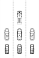
つまり、管理サーバ100は、前記コネクテッドカーのうち、前記メタデータの少なくとも一部を生成するために利用される一つ以上のリファレンス車両を選択するが、ここで前記リファレンス車両は、前記特定緊急車両との関係が直接インタラクション条件及び間接インタラクション条件の少なくとも一つを満足することを特徴とする。ここで直接インタラクション条件は、コネクテッドカーのうちの一つが、特定緊急車両を自身のイメージセンサで直接撮影できるか否かに対する条件であり得る。一方、間接インタラクション条件は、コネクテッドカーのうちの一つが、自身のイメージセンサで、特定緊急車両を撮影できる所定コネクテッドカーのうちの一部を撮影できるか否かに対する条件を意味し得る。例えば、直接インタラクション条件を満足するリファレンス車両のうち一部を第1リファレンス車両であるとすれば、このような第1リファレンス車両を撮影できるリファレンス車両のうちの他の一部は、間接インタラクション条件を満足して第2リファレンス車両として選択され得るということである。それぞれのコネクテッドカーが、このような直接的な条件及び間接的な条件のいずれかを満足しているか否かは、前述の特定緊急車両の初期位置情報と、その周辺に位置する一部のコネクテッドカーのイメージセンサの方向とを参照にして判断され得るだろう。これに関する例を見るために、図3を参照する。 That is, the management server 100 selects one or more reference vehicles that are used to generate at least part of the metadata from among the connected cars. Here, the reference vehicle is the specific emergency vehicle. satisfies at least one of a direct interaction condition and an indirect interaction condition. Here, the direct interaction condition may be a condition as to whether or not one of the connected cars can directly image the specific emergency vehicle with its own image sensor. On the other hand, the indirect interaction condition may refer to a condition as to whether one of the connected cars can capture, with its image sensor, some of the predetermined connected cars that can capture the specific emergency vehicle. For example, if some of the reference vehicles that satisfy the direct interaction condition are the first reference vehicles, some of the other reference vehicles that can photograph the first reference vehicle satisfy the indirect interaction condition. It can be satisfactorily selected as a second reference vehicle. Whether each connected car satisfies either of these direct and indirect conditions depends on the initial location information of the specific emergency vehicle described above and some connected vehicles located in the vicinity. It could be determined with reference to the orientation of the car's image sensor. To see an example of this, refer to FIG.
図3は、本発明の一実施例に係る各緊急車両をリアルタイムで検出し、前記緊急車両それぞれに対する検出された情報を利用することで、前記緊急車両それぞれが前記対象車両の干渉なしで走行できるように対象車両を管理する方法を遂行するために利用される、選択された各リファレンス車両の一例を示した図面である。 FIG. 3 is a diagram illustrating real-time detection of each emergency vehicle according to an embodiment of the present invention, and use of the detected information for each of the emergency vehicles so that each of the emergency vehicles can run without interference from the target vehicle. FIG. 10 is a diagram showing an example of each selected reference vehicle used to perform the method of managing target vehicles. FIG.
図3を参照すれば、コネクテッドカーに搭載された各イメージセンサが正面方向に向かっている場合、特定緊急車両のすぐ後ろに位置した各車両(A)が各第1リファレンス車として選択され、各第1リファレンス車両の後ろに位置した各車両(B)が各第2リファレンス車として選ばれたことを確認することができる。 Referring to FIG. 3, when each image sensor mounted on the connected car faces the front, each vehicle (A) positioned immediately behind the specific emergency vehicle is selected as each first reference vehicle. It can be confirmed that each vehicle (B) positioned behind the first reference vehicle is selected as each second reference vehicle.
その後、それぞれのリファレンス車両は、リファレンス車両それぞれと特定緊急車両との間の相対的な位置またはリファレンス車両間の相対的な位置それぞれを示す相対座標それぞれを伝送することができる。具体的には、各第1リファレンス車両は、自身に搭載されたイメージセンサ、レーダセンサ及びライダセンサのうちの少なくとも一部を利用して、前記第1リファレンス車両それぞれから特定緊急車両の相対的な位置を予測することで、各相対座標のうちの一つ以上の特定緊急車両相対座標を生成することができる。イメージセンサを利用する場合、広く知られているイメージプロセッシング技術を用いて、特定緊急車両とそれぞれの第1リファレンス車両との間の縦方向及び横方向の距離を計算することができる。レーダセンサまたはライダセンサを利用する場合、縦方向及び横方向の距離を求めるために、管理サーバ100は、レーダ及びライダセンサによって検出された物体を予め設定された車両位置マップ(バードビューマップ)上の物体とマッチングさせることができる。また、各第2リファレンス車両は、自身に搭載されたイメージセンサ、レーダセンサ及びライダセンサのうちの少なくとも一部を利用して、前記第2リファレンス車両それぞれから第1リファレンス車両それぞれの相対的な位置を予測することで、相対座標それぞれのうちの一つ以上の第1リファレンス車両相対座標を生成することができる。第1リファレンス車両相対座標を取得する特定プロセスは、特定緊急車両相対座標を取得するプロセスと類似し得る。 Each reference vehicle can then transmit respective relative coordinates indicating the relative position between the respective reference vehicle and the specific emergency vehicle or the relative position between the reference vehicles. Specifically, each first reference vehicle uses at least a part of an image sensor, a radar sensor, and a lidar sensor mounted on the vehicle to determine the relative position of the specific emergency vehicle from each of the first reference vehicles. can generate one or more specific emergency vehicle relative coordinates of each relative coordinate by estimating . If an image sensor is used, well-known image processing techniques can be used to calculate the longitudinal and lateral distances between the particular emergency vehicle and the respective first reference vehicle. When using a radar sensor or a lidar sensor, the management server 100 maps objects detected by the radar and lidar sensors to objects on a preset vehicle position map (bird view map) in order to obtain vertical and horizontal distances. can be matched with Further, each second reference vehicle uses at least a part of an image sensor, a radar sensor, and a lidar sensor mounted on the second reference vehicle to detect the relative position of each of the first reference vehicles from each of the second reference vehicles. The prediction can generate one or more first reference vehicle relative coordinates for each of the relative coordinates. The identifying process of obtaining the first reference vehicle relative coordinates may be similar to the process of obtaining specific emergency vehicle relative coordinates.
その後、管理サーバ100は、前記第1リファレンス車両それぞれの絶対座標と、これに対応する前記特定緊急車両相対座標とを参照にして、前記第1リファレンス車両を基盤にした一つ以上の各第1特定緊急車両絶対座標を生成することができる。また、管理サーバ100は、前記第2リファレンス車両それぞれの絶対座標と、これに対応する前記第1リファレンス車両相対座標と、これに対応する前記特定緊急車両相対座標とを参照にして、前記第2リファレンス車両を基盤にした一つ以上の各第2特定緊急車両絶対座標を生成することができる。 After that, the management server 100 refers to the absolute coordinates of each of the first reference vehicles and the corresponding relative coordinates of the specific emergency vehicle to generate one or more respective first reference vehicles based on the first reference vehicles. Specific emergency vehicle absolute coordinates can be generated. In addition, the management server 100 refers to the absolute coordinates of each of the second reference vehicles, the corresponding first reference vehicle relative coordinates, and the corresponding specific emergency vehicle relative coordinates to refer to the second reference vehicle. One or more absolute coordinates of each second specific emergency vehicle can be generated based on the reference vehicle.
ここで、各第1特定緊急車両絶対座標は、前記特定緊急車両相対座標(つまり、イメージセンサ、またはレーダ/ライダセンサを利用して計算された距離)を、これに対応する各第1リファレンス車両の絶対座標(自身のGPSから取得される)に足して計算されたものであるので、各第1特定緊急車両絶対座標は、特定緊急車両のGPSの誤差が反映された、特定緊急車両の初期位置情報より正確であり得る。同様に、第2特定緊急車両絶対座標も、各第2リファレンス車両の絶対座標に、第1リファレンス車両相対座標を足して特定合計を生成した後、これに対応する特定緊急車両相対座標を前記特定合計に追加して計算するので、第2特定緊急車両絶対座標は、特定緊急車両の初期位置情報よりも正確であり得る。 Here, each first specific emergency vehicle absolute coordinate is the specific emergency vehicle relative coordinate (that is, the distance calculated using an image sensor or radar/lidar sensor) of each corresponding first reference vehicle. Since they are calculated in addition to the absolute coordinates (obtained from the own GPS), each first specific emergency vehicle absolute coordinate is the initial position of the specific emergency vehicle, reflecting the GPS error of the specific emergency vehicle. Information can be more accurate. Similarly, for the second specific emergency vehicle absolute coordinates, after adding the first reference vehicle relative coordinates to the absolute coordinates of each second reference vehicle to generate a specific sum, the corresponding specific emergency vehicle relative coordinates are calculated as the specific sum. Since it is calculated in addition to the sum, the second specific emergency vehicle absolute coordinates may be more accurate than the initial position information of the specific emergency vehicle.
したがって、管理サーバ100は、第1特定緊急車両絶対座標及び各第2特定緊急車両絶対座標のうちの少なくとも一部を参照にして、初期位置よりも正確な特定緊急車両の少なくとも一つの最終位置を予測することで、前述したメタデータの少なくとも一部を生成することができる。一例として、第1特定緊急車両絶対座標及び各第2特定緊急車両絶対座標の加重和は、前記メタデータの少なくとも一部を生成するために利用されることができる。 Therefore, the management server 100 refers to at least a part of the absolute coordinates of the first specific emergency vehicle and the absolute coordinates of each of the second specific emergency vehicles to determine at least one final position of the specific emergency vehicle that is more accurate than the initial position. The prediction can generate at least some of the metadata described above. As an example, a weighted sum of the first specific emergency vehicle absolute coordinates and each second specific emergency vehicle absolute coordinates can be utilized to generate at least part of the metadata.
前述した説明においては、各第2リファレンス車両を、各第1リファレンス車両を撮影できる車両であると仮定している。しかし、第2リファレンス車両を第1リファレンス車両によって撮影された車両であると仮定する他の実施例も可能である。この場合には、第2特定緊急車両絶対座標は、(s1)第1リファレンス車両を基準にした第2リファレンス車両の相対座標を(s2)第2リファレンス車両絶対座標から引いた後、特定緊急車両相対座標を足すことで、第2特定緊急車両絶対座標を計算することができるであろう。もちろん、両実施例の結合も可能であろう。 In the above description, it is assumed that each second reference vehicle is a vehicle capable of photographing each first reference vehicle. However, other embodiments are possible where the second reference vehicle is assumed to be the vehicle photographed by the first reference vehicle. In this case, the absolute coordinates of the second specific emergency vehicle are obtained by subtracting (s1) the relative coordinates of the second reference vehicle with respect to the first reference vehicle from (s2) the absolute coordinates of the second reference vehicle. By adding the relative coordinates, the second specific emergency vehicle absolute coordinates could be calculated. Of course, a combination of both embodiments would also be possible.
その後、管理サーバ100は、特定緊急車両の予測された位置に対する情報を含むメタデータを参照にして、コネクテッドカーのうちの特定条件を満足する対象車両を選択することができる。ここで、特定条件を満足する個々の対象車両と特定緊急車両との間の距離は、第3閾値以下であり得る。その後、管理サーバ100は、前記メタデータを参照にして、前記特定緊急車両及び前記対象車両それぞれの位置情報を仮想平面上にマッピングすることにより前記状況シナリオベクトルを生成することができる。すなわち、特定緊急車両及び対象車両がどのように配列されているかについての情報を含む状況シナリオベクトルを生成するのである。その後、管理サーバ100は、シナリオDB130から取得された各リファレンスシナリオベクトルと状況シナリオベクトルとに含まれた要素の配列を比較して、前記状況シナリオベクトルと前記それぞれのリファレンスシナリオベクトルとの間の類似度スコアを計算することによって一つ以上の候補シナリオベクトルを選択することができる。ここで、候補シナリオベクトルは、類似度スコアが最も大きいN個のシナリオベクトルの一部であり得る。その後、管理サーバ100は、前記緊急状況情報に含まれた特定緊急車両のクラス及び特徴に対する情報を参照にして、前記候補シナリオベクトルそれぞれのうちの前記特定シナリオベクトルを選択することができる。その後、管理サーバ100は、シナリオDB130から特定シナリオベクトルに対応する緊急リアクションコマンドを取得し、緊急リアクションコマンドを対象車両に伝送することによって特定緊急車両と各対象車両との間の干渉度スコアが第2閾値以下になるように制御しながら、前記特定緊急車両と前記対象車両それぞれとを運行できるように支援することができる。これに対する例示を見てみるために、図4を参照する。
After that, the management server 100 can select a target vehicle that satisfies a specific condition among the connected cars by referring to the metadata including information on the predicted location of the specific emergency vehicle. Here, the distance between each target vehicle that satisfies the specific condition and the specific emergency vehicle may be less than or equal to the third threshold. After that, the management server 100 can generate the situation scenario vector by mapping the position information of each of the specific emergency vehicle and the target vehicle on a virtual plane with reference to the metadata. That is, a situation scenario vector is generated that contains information about how the specific emergency vehicles and target vehicles are arranged. After that, the management server 100 compares the arrangement of elements included in each reference scenario vector and the situation scenario vector acquired from the
図4は、本発明の一実施例に係る各緊急車両をリアルタイムで検出し、前記緊急車両それぞれに対する検出された情報を利用して前記緊急車両それぞれが前記対象車両それぞれからの干渉なしで走行できるように対象車両を管理する方法を遂行するために状況シナリオベクトルを利用して緊急リアクションコマンドを生成する一例を示した図面である。 FIG. 4 is a diagram for detecting each emergency vehicle in real time according to one embodiment of the present invention, and using the detected information for each of the emergency vehicles, each of the emergency vehicles can run without interference from each of the target vehicles. FIG. 10 is a diagram showing an example of generating an emergency reaction command using a situation scenario vector to perform a method of managing a target vehicle; FIG.
図4を参照にすれば、各リファレンスシナリオベクトルのうちの各状況シナリオベクトルとより類似した各候補シナリオベクトル210,220が選択されたことを確認することができる。また、救急車及びパトロールカーそれぞれに対応するそれぞれの各候補シナリオベクトル210,220のうち、救急車に該当する状況シナリオベクトルとさらに類似した候補シナリオベクトル210のうちの一つが選択されたことを確認することができるであろう。この場合、救急車は素早く当該区間を通過しなければならないので、緊急リアクションコマンド230は、図4に描写されたように、各対象車両が道路の側面に移動するためのコマンドであり得る。図4に表現されているものは、単なる例示である。つまり、追加で特定緊急車両が、例えば道路の左側、右側または道路の中心に位置することによって、緊急リアクションコマンドは、右側、左側または側面に避けるのか、などによって決定され得る。
Referring to FIG. 4, it can be confirmed that
このような過程によって、前記特定緊急車両と前記対象車両それぞれとの間の干渉度スコアが第2閾値以下になるように制御しながら、前記特定緊急車両と前記対象車両それぞれとを運行することができる。しかし、実際の走行中には、問題が生じ得る。したがって、このような問題を防止するためのフィードバック過程を次に説明する。 Through this process, the specific emergency vehicle and the target vehicle can be operated while controlling the degree of interference score between the specific emergency vehicle and the target vehicle to be equal to or lower than the second threshold. can. However, problems can arise during actual driving. Therefore, a feedback process for preventing such problems will now be described.
つまり、管理サーバ100は、緊急リアクションコマンドを対象車両に送り、対象車両から持続的に干渉度スコアを受信することができる。ここで、前記特定緊急車両と前記対象車両それぞれとの間の干渉度スコアは、(i)前記特定緊急車両及び前記対象車両それぞれの間の距離情報と、前記距離情報に対する変化情報との組み合わせ、及び(ii)前記緊急リアクションコマンドと、前記特定緊急車両それぞれの実際運行アクションそれぞれとの間の差異情報のうち少なくとも一部を参照にして計算されることができる。前記変化情報は、前記特定緊急車両と前記対象車両それぞれとの間の距離の変化を示すことができる。前記距離が第6限界値以下で急激に変化する状況は、特定緊急車両と対象車両の少なくとも一部とのそれぞれの間が干渉状況であることを示すものであると見ることができるので、このような距離情報及び変化情報の組み合わせは、干渉度スコアを生成するために利用され得る。また、緊急リアクションコマンドと、特定緊急車両それぞれの実際運行アクションそれぞれとの間の差異情報は、対象車両の一部が緊急リアクションコマンドに従って走行しているうちに特定緊急車両と相互干渉して事故リスクが高くなる場合に大きくなり得る。 That is, the management server 100 can send an emergency reaction command to the target vehicle and continuously receive the interference degree score from the target vehicle. Here, the degree of interference score between the specific emergency vehicle and each of the target vehicles is obtained by (i) a combination of distance information between each of the specific emergency vehicle and the target vehicle and change information with respect to the distance information; and (ii) with reference to at least a part of difference information between the emergency reaction command and each actual operation action of each of the specific emergency vehicles. The change information can indicate a change in distance between the specific emergency vehicle and each of the target vehicles. A situation in which the distance changes abruptly below the sixth limit value can be regarded as indicating a situation of interference between the specific emergency vehicle and at least a portion of the target vehicle. A combination of such distance information and change information can be utilized to generate a coherence score. In addition, the difference information between the emergency reaction command and each actual operation action of each specific emergency vehicle can be used to reduce the risk of accidents due to mutual interference with the specific emergency vehicle while part of the target vehicle is traveling according to the emergency reaction command. can be large when is high.
これをもとに、前記干渉度スコアの少なくとも一部の時間が前記第2閾値より大きく維持される時間が第5閾値以上である場合、管理サーバ100は、以前伝送された緊急リアクションコマンドをキャンセルし、当該時点の前記特定緊急車両の他のメタデータを生成し、前記他のメタデータを参照にして当該時点に対する他の緊急リアクションコマンドを生成し、当該時点の間に他の対象車両に対する前記他の緊急リアクションコマンドを伝送することができる。ここで、他のメタデータ、前記他の緊急リアクションコマンド及び前記他の対象車両は、前記S01段階ないし前記S05段階の時点より遅い時点に該当する。このような方法で、特定緊急車両は事故の危険なく、適切に走行できるようになる。 Based on this, the management server 100 cancels the previously transmitted emergency reaction command if the time period for which at least a portion of the interference score is maintained greater than the second threshold is greater than or equal to the fifth threshold. generate other metadata of the specific emergency vehicle at the time point, generate another emergency reaction command for the time point with reference to the other metadata, and generate the other emergency reaction command for the other target vehicle during the time point Other emergency reaction commands can be transmitted. Here, the other metadata, the other emergency reaction command, and the other target vehicle correspond to a time later than the steps S01 to S05. In this way, the specific emergency vehicle will be able to run properly without risk of accident.
前記過程と並行して、管理サーバ100は、前記特定緊急車両からの距離が第4閾値よりも近い特定コネクテッドカー及び特定の通信接続された歩行者のうちの少なくとも一部にアラームを伝送することができる。特定コネクテッドカーの場合、これらのヘッドアップディスプレイによって提供され得、特定の通信接続された歩行者の場合は、歩行者らのスマートフォンによってアラームが提供され得る。 In parallel with the above process, the management server 100 transmits an alarm to at least some of the specific connected car and the specific pedestrians who are connected to the communication, the distance from the specific emergency vehicle being closer than the fourth threshold. can be done. In the case of certain connected cars, these head-up displays may provide, and in the case of certain connected pedestrians, the alarm may be provided by the pedestrian's smart phone.
以上で説明された本発明に係る実施例は、多様なコンピュータ構成要素を通じて遂行できるプログラム命令語の形態で具現されてコンピュータ読取り可能な記録媒体に記録され得る。前記コンピュータで読取り可能な記録媒体はプログラム命令語、データファイル、データ構造などを単独でまたは組み合わせて含まれ得る。前記コンピュータ読取り可能な記録媒体に記録されるプログラム命令語は、本発明のために特別に設計されて構成されたものであるか、コンピュータソフトウェア分野の当業者に公知となって利用可能なものでもよい。コンピュータで判読可能な記録媒体の例には、ハードディスク、フロッピィディスク及び磁気テープのような磁気媒体、CD-ROM、DVDのような光記録媒体、フロプティカルディスク(flopticaldisk)のような磁気-光媒体(magneto-opticalmedia)、及びROM、RAM、フラッシュメモリなどといったプログラム命令語を格納して遂行するように特別に構成されたハードウェア装置が含まれる。プログラム命令語の例には、コンパイラによって作られるもののような機械語コードだけでなく、インタプリタなどを用いてコンピュータによって実行され得る高級言語コードも含まれる。前記ハードウェア装置は、本発明に係る処理を遂行するために一つ以上のソフトウェアモジュールとして作動するように構成され得、その逆も同様である。 The embodiments according to the present invention described above can be embodied in the form of program instructions that can be executed through various computer components and recorded on a computer-readable recording medium. The computer-readable recording medium may include program instructions, data files, data structures, etc. alone or in combination. The program instruction words recorded on the computer-readable recording medium may be those specially designed and configured for the present invention, or those known and available to those skilled in the computer software field. good. Examples of computer readable recording media include magnetic media such as hard disks, floppy discs and magnetic tapes, optical recording media such as CD-ROMs and DVDs, magneto-optical media such as floptical disks. It includes magneto-optical media and hardware devices specially configured to store and execute program instructions such as ROM, RAM, flash memory, and the like. Examples of program instruction words include not only machine language code, such as that produced by a compiler, but also high-level language code that can be executed by a computer using an interpreter or the like. The hardware device may be configured to act as one or more software modules to perform the processes of the present invention, and vice versa.
以上、本発明が具体的な構成要素などのような特定事項と限定された実施例及び図面によって説明されたが、これは本発明のより全般的な理解を助けるために提供されたものであるに過ぎず、本発明が前記実施例に限られるものではなく、本発明が属する技術分野において通常の知識を有する者であれば係る記載から多様な修正及び変形が行われ得る。 Although the present invention has been described with specific details such as specific components and limited examples and drawings, this is provided to aid in a more general understanding of the present invention. However, the present invention is not limited to the above-described embodiments, and various modifications and variations can be made from the description by those who have ordinary knowledge in the technical field to which the present invention belongs.
従って、本発明の思想は前記説明された実施例に局限されて定められてはならず、後述する特許請求の範囲だけでなく、本特許請求の範囲と均等または等価的に変形されたものすべては、本発明の思想の範囲に属するといえる。 Therefore, the spirit of the present invention should not be limited to the above-described embodiments, and should not be limited to the scope of the claims set forth below, as well as all modifications equivalent or equivalent to the scope of the claims. belongs to the scope of the idea of the present invention.
Claims (18)
(a)管理サーバが、前記対象車両を含む一つ以上のコネクテッドカー(Connected car)の少なくとも一部に搭載された一つ以上のイメージ基盤センサを通じて撮影されたイメージを利用して前記緊急車両のうちの少なくとも一つの特定緊急車両を検出した結果に対する緊急状況情報が取得されると、前記緊急状況情報を参照にして、前記コネクテッドカーの中で、自身に搭載された一つ以上のイメージ基盤センサを利用して撮影されたイメージを利用して前記特定緊急車両を検出した車両を第1リファレンス車両として選択し、前記第1リファレンス車両それぞれに搭載された一つ以上のイメージ基盤センサを利用して検出された他の車両及び自身に搭載された一つ以上のイメージ基盤センサを利用して撮影されたイメージを利用して、前記第1リファレンス車両のうち、少なくとも一つの車両を検出したもう一つの車両を第2リファレンス車両として選択し、前記第1リファレンス車両及び前記第2リファレンス車両のそれぞれと前記特定緊急車両との位置関係を利用し、前記特定緊急車両に対するメタデータを生成する段階;
(b)前記管理サーバが、(i)前記緊急状況情報及び前記メタデータを参照にして、前記特定緊急車両、前記第1リファレンス車両、及び前記第2リファレンス車両を仮想平面上にマッピングしてバードビューイメージを生成し、前記バードビューイメージにおける前記特定緊急車両、前記第1リファレンス車両、及び前記第2リファレンス車両の配列情報による少なくとも一つの状況シナリオベクトルを生成し、(ii)前記状況シナリオベクトルを、シナリオデータベースに含まれている一つ以上の各リファレンスシナリオベクトルと比較することで、前記状況シナリオベクトルとの類似度スコアが第1閾値以上である少なくとも一つの特定シナリオベクトルを見つけ、(iii)前記特定シナリオベクトルを参照にして緊急リアクションコマンドを取得する段階;及び
(c)前記管理サーバが、前記緊急リアクションコマンドを、前記特定緊急車両との関係が特定条件を満足するそれぞれの前記対象車両に伝送することにより、前記特定緊急車両と前記対象車両との間の干渉度スコアが第2閾値以下になるように制御しながら運行できるように支援する段階;
を含み、
前記(a)段階は、
前記緊急状況情報のうちの少なくとも一部は、前記特定緊急車両が含まれた特定イメージを処理するニューラルネットワークにより生成され、
(i)前記ニューラルネットワークそれぞれのうちの第1ニューラルネットワークが、前記特定イメージに少なくとも一つの第1CNN演算を適用して前記特定イメージが前記特定緊急車両に対応するグローバル視点特徴(global visional feature)を含んでいるか否かを判断することにより第1判断情報を生成するようにし、(ii)前記ニューラルネットワークそれぞれのうちの第2ニューラルネットワークが、前記特定イメージ上の予め設定された特定領域に少なくとも一つの第2CNN演算を適用して前記特定イメージが前記特定緊急車両に対応するローカル視点特徴(local visional feature)を含んでいるか否かを判断することにより第2判断情報を生成するようにし、(iii)前記ニューラルネットワークそれぞれのうちの第3ニューラルネットワークが、前記予め設定された特定領域に少なくとも一つの第3CNN演算を適用して、前記特定イメージが前記特定緊急車両に対応するローカル時間特徴(local temporal feature)を含んでいるか否かを判断することにより第3判断情報を生成するようにした状態で、前記第1ないし第3判断情報を参照にして、前記緊急状況情報の一部が生成されることを特徴とする方法。 Detecting each of one or more emergency vehicles in real-time, referring to the detected information for each of the emergency vehicles, and controlling the target vehicle so that each of the emergency vehicles can travel without interference from one or more target vehicles. in the method of managing the
(a) the management server uses images captured by one or more image-based sensors installed in at least a portion of one or more connected cars including the target vehicle to identify the emergency vehicle; When the emergency situation information for the result of detecting at least one specific emergency vehicle is obtained, one or more image-based sensors installed in the connected car refer to the emergency situation information. selecting a vehicle that detects the specific emergency vehicle as a first reference vehicle using an image captured using Another vehicle that detects at least one of the first reference vehicles using images captured using one or more image-based sensors mounted on the vehicle and the other vehicle that is detected. selecting a vehicle as a second reference vehicle, and generating metadata for the specific emergency vehicle using positional relationships between each of the first reference vehicle and the second reference vehicle and the specific emergency vehicle;
(b) The management server (i) maps the specific emergency vehicle, the first reference vehicle, and the second reference vehicle on a virtual plane with reference to the emergency situation information and the metadata, and generating a view image, generating at least one situation scenario vector based on arrangement information of the specific emergency vehicle, the first reference vehicle, and the second reference vehicle in the bird view image; (ii) generating the situation scenario vector; , finding at least one specific scenario vector whose similarity score with said situation scenario vector is greater than or equal to a first threshold by comparing with each of one or more reference scenario vectors contained in a scenario database; (iii) obtaining an emergency reaction command with reference to the specific scenario vector; and (c) sending the emergency reaction command to each of the target vehicles whose relationship with the specific emergency vehicle satisfies a specific condition. a step of supporting operation while controlling an interference score between the specific emergency vehicle and the target vehicle to be equal to or less than a second threshold by transmitting;
including
The step (a) includes
at least part of the emergency situation information is generated by a neural network processing a specific image including the specific emergency vehicle;
(i) a first neural network of each of said neural networks applying at least one first CNN operation to said particular image to derive a global visional feature that said particular image corresponds to said particular emergency vehicle; (ii) a second neural network out of each of the neural networks includes at least one image in a predetermined specific region on the specific image; applying two second CNN operations to determine whether the specific image includes a local vision feature corresponding to the specific emergency vehicle to generate second determination information; ) a third neural network of each of said neural networks applies at least one third CNN operation to said predetermined specific region to obtain a local temporal feature that said specific image corresponds to said specific emergency vehicle; A part of the emergency situation information is generated with reference to the first to third determination information in a state in which third determination information is generated by determining whether or not the feature) is included. A method characterized by:
前記管理サーバが、前記コネクテッドカーのうち、前記メタデータの少なくとも一部を生成するために利用される少なくとも一つのリファレンス車両を選択し、前記リファレンス車両と前記特定緊急車両との間の相対的な位置を示す相対座標を参照にして、前記特定緊急車両の少なくとも一つの位置を予測することにより前記メタデータのうちの少なくとも一部を生成し、前記リファレンス車両は、前記特定緊急車両との関係が直接インタラクション条件及び間接インタラクション条件のうちの少なくとも一つを満たし、前記直接インタラクション条件は、前記コネクテッドカーのうちの一つが、前記特定緊急車両を自身のイメージセンサで直接撮影できるか否かに関するものであり、前記間接インタラクション条件は、前記コネクテッドカーのうちの一つが、自身のイメージセンサで、前記特定緊急車両を撮影できる所定のコネクテッドカーのうちの一部を撮影できるか否かに関するものであることを特徴とする請求項1に記載の方法。 The step (a) includes
The management server selects at least one reference vehicle that is used to generate at least part of the metadata from among the connected cars, and performs a relative comparison between the reference vehicle and the specific emergency vehicle. At least part of the metadata is generated by predicting the position of at least one of the specific emergency vehicles with reference to relative coordinates indicating positions, and the reference vehicle has a relationship with the specific emergency vehicle. At least one of a direct interaction condition and an indirect interaction condition is satisfied, and the direct interaction condition relates to whether or not one of the connected cars can directly photograph the specific emergency vehicle with its own image sensor. and the indirect interaction condition relates to whether or not one of the connected cars can capture, with its own image sensor, a portion of predetermined connected cars that can capture the specific emergency vehicle. 2. The method of claim 1, characterized by:
前記管理サーバが、前記特定緊急車両の予測された前記位置を参照にして、前記コネクテッドカーのうちの、前記特定緊急車両からの距離が第3閾値以下である前記特定条件を満足する前記対象車両それぞれを選択することを特徴とする請求項2に記載の方法。 The step (c) includes
The management server refers to the predicted position of the specific emergency vehicle, and among the connected cars, the target vehicle that satisfies the specific condition that the distance from the specific emergency vehicle is equal to or less than a third threshold. 3. The method of claim 2, wherein each is selected.
(i)前記リファレンス車両それぞれのうちの前記直接インタラクション条件を満足する一つ以上の各第1リファレンス車両は、自身に搭載された一つ以上のイメージセンサ、一つ以上のレーダセンサ及び一つ以上のライダセンサのうちの少なくとも一部を利用して、前記第1リファレンス車両それぞれから前記特定緊急車両の相対的な位置を予測することで、前記相対座標のうちの一つ以上の特定緊急車両相対座標を生成し、(ii)前記リファレンス車両それぞれのうちの、前記間接インタラクション条件を満足する一つ以上の各第2リファレンス車両は、自身に搭載された一つ以上のイメージセンサ、一つ以上のレーダセンサ及び一つ以上のライダセンサのうちの少なくとも一部を利用して、前記第2リファレンス車両それぞれから前記第1リファレンス車両それぞれの相対的な位置を予測することで、前記相対座標のうちの一つ以上の第1リファレンス車両相対座標を生成し、(iii)前記第1リファレンス車両及び前記第2リファレンス車両それぞれは、前記相対座標を前記管理サーバに伝送することを特徴とする請求項2に記載の方法。 The step (a) includes
(i) each of the one or more first reference vehicles among each of the reference vehicles that satisfies the direct interaction condition has one or more image sensors, one or more radar sensors and one or more mounted therein; one or more specific emergency vehicle relative coordinates among the relative coordinates by predicting the relative position of the specific emergency vehicle from each of the first reference vehicles using at least part of the lidar sensors of and (ii) each of the one or more second reference vehicles among the reference vehicles that satisfies the indirect interaction condition is equipped with one or more image sensors, one or more radars one of the relative coordinates by predicting the relative position of each of the first reference vehicles from each of the second reference vehicles using at least some of the sensors and one or more lidar sensors; (iii) each of the first reference vehicle and the second reference vehicle transmits the relative coordinates to the management server; Method.
前記管理サーバが、(i)前記メタデータを参照にして、前記特定緊急車両及び前記対象車両それぞれの位置情報を仮想平面上にマッピングすることにより前記状況シナリオベクトルを生成し、(ii)前記状況シナリオベクトルと前記それぞれのリファレンスシナリオベクトルとの間の類似度スコアを計算することにより、一つ以上の候補シナリオベクトルを選択し、(iii)前記緊急状況情報を参照にして、前記候補シナリオベクトルそれぞれのうちの前記特定シナリオベクトルを選択することを特徴とする請求項1に記載の方法。 The step (b) includes
The management server (i) generates the situation scenario vector by mapping the position information of each of the specific emergency vehicle and the target vehicle on a virtual plane with reference to the metadata, and (ii) the situation selecting one or more candidate scenario vectors by calculating a similarity score between the scenario vector and the respective reference scenario vector; (iii) referring to the emergency situation information, each of the candidate scenario vectors; 2. The method of claim 1, wherein the particular scenario vector is selected from:
前記対象車両が、(i)(i-1)前記特定緊急車両とそれぞれの前記対象車両との間の距離情報及び前記距離情報に対する変化情報の組み合わせ及び(i-2)前記緊急リアクションコマンドと、前記特定緊急車両のそれぞれの実際運行アクションとの間の差異情報のうちの少なくとも一部を参照にして、前記特定緊急車両との前記干渉度スコアを計算した後(ii)前記管理サーバに前記干渉度スコアを伝送することを特徴とする請求項1に記載の方法。 The step (c) includes
(i) (i-1) a combination of distance information between the specific emergency vehicle and each of the target vehicles and change information for the distance information; and (i-2) the emergency reaction command; (ii) after calculating the degree of interference score with the specific emergency vehicle by referring to at least part of the difference information between each actual operation action of the specific emergency vehicle; 2. A method according to claim 1, characterized by transmitting a degree score.
をさらに含み、
前記(d)段階での前記他のメタデータ、前記他の緊急リアクションコマンド及び前記他の対象車両は、前記(a)段階ないし前記(c)段階の時点より遅い時点に該当することを特徴とする請求項1に記載の方法。 (d) when the management server determines that the time for which the interference score is maintained to be greater than the second threshold is equal to or greater than a fifth threshold, (i) the interference score is maintained to be greater than the second threshold; generating other metadata of the specific emergency vehicle at the corresponding point in time when the time is equal to or greater than the fifth threshold ; (ii) referring to the other metadata to generate another emergency reaction command for the corresponding point in time; iii) transmitting said other emergency reaction command to another target vehicle during said time;
further comprising
The other metadata, the other emergency reaction command, and the other target vehicle in step (d) correspond to a point in time later than steps (a) to (c). The method of claim 1, wherein
少なくとも一つの各インストラクションを格納する少なくとも一つのメモリ;及び
前記インストラクションそれぞれを遂行するように設定された少なくとも一つのプロセッサを含み、前記プロセッサは、(I)前記対象車両を含む一つ以上のコネクテッドカーの少なくとも一部に搭載された一つ以上のイメージ基盤センサを通じて撮影されたイメージを利用して前記緊急車両のうちの少なくとも一つの特定緊急車両を検出した結果に対する緊急状況情報が取得されると、前記緊急状況情報を参照にして、前記コネクテッドカーの中で、自身に搭載された一つ以上のイメージ基盤センサを利用して撮影されたイメージを利用して前記特定緊急車両を検出した車両を第1リファレンス車両として選択し、前記第1リファレンス車両それぞれに搭載された一つ以上のイメージ基盤センサを利用して検出された他の車両及び自身に搭載された一つ以上のイメージ基盤センサを利用して撮影されたイメージを利用して、前記第1リファレンス車両のうち、少なくとも一つの車両を検出したもう一つの車両を第2リファレンス車両として選択し、前記第1リファレンス車両及び前記第2リファレンス車両のそれぞれと前記特定緊急車両との位置関係を利用し、前記特定緊急車両に対するメタデータを生成するプロセス;及び(II)(i)前記緊急状況情報及び前記メタデータを参照にして、前記特定緊急車両、前記第1リファレンス車両、及び前記第2リファレンス車両を仮想平面上にマッピングしてバードビューイメージを生成し、前記バードビューイメージにおける前記特定緊急車両、前記第1リファレンス車両、及び前記第2リファレンス車両の配列情報による少なくとも一つの状況シナリオベクトルを生成し、(ii)前記状況シナリオベクトルを、シナリオデータベースに含まれている一つ以上の各リファレンスシナリオベクトルと比較することで、前記状況シナリオベクトルとの類似度スコアが第1閾値以上である少なくとも一つの特定シナリオベクトルを見つけ、(iii)前記特定シナリオベクトルを参照にして緊急リアクションコマンドを取得するプロセス;及び(III)前記緊急リアクションコマンドを、前記特定緊急車両との関係が特定条件を満足するそれぞれの前記対象車両に伝送することにより、前記特定緊急車両と前記対象車両との間の干渉度スコアが第2閾値以下になるように制御しながら運行できるように支援するプロセス;を遂行し、
前記(I)プロセスは、
前記緊急状況情報のうちの少なくとも一部は、前記特定緊急車両が含まれた特定イメージを処理するニューラルネットワークにより生成され、
(i)前記ニューラルネットワークそれぞれのうちの第1ニューラルネットワークが、前記特定イメージに少なくとも一つの第1CNN演算を適用して前記特定イメージが前記特定緊急車両に対応するグローバル視点特徴(global visional feature)を含んでいるか否かを判断することにより第1判断情報を生成するようにし、(ii)前記ニューラルネットワークそれぞれのうちの第2ニューラルネットワークが、前記特定イメージ上の予め設定された特定領域に少なくとも一つの第2CNN演算を適用して前記特定イメージが前記特定緊急車両に対応するローカル視点特徴(local visional feature)を含んでいるか否かを判断することにより第2判断情報を生成するようにし、(iii)前記ニューラルネットワークそれぞれのうちの第3ニューラルネットワークが、前記予め設定された特定領域に少なくとも一つの第3CNN演算を適用して、前記特定イメージが前記特定緊急車両に対応するローカル時間特徴(local temporal feature)を含んでいるか否かを判断することにより第3判断情報を生成するようにした状態で、前記第1ないし第3判断情報を参照にして、前記緊急状況情報の一部が生成されることを特徴とする装置。 Detecting each of one or more emergency vehicles in real time, referring to the detected information for each of the emergency vehicles, and managing the target vehicles so that the emergency vehicles can travel without interference from one or more target vehicles. In a device that
at least one memory storing at least one respective instruction; and at least one processor configured to execute each of said instructions, said processor comprising: (I) one or more connected vehicles including said subject vehicle; when emergency situation information is acquired for the result of detecting at least one specific emergency vehicle among the emergency vehicles using images captured by one or more image-based sensors installed in at least a part of the Referring to the emergency situation information, among the connected cars, a vehicle that detects the specific emergency vehicle using an image captured using one or more image-based sensors installed in itself is selected as the first. Select one reference vehicle and use one or more image-based sensors installed in other vehicles and one or more image-based sensors installed in the first reference vehicle detected by using one or more image-based sensors installed in each of the first reference vehicles. using the image captured by the first reference vehicle, another vehicle from which at least one vehicle has been detected is selected as a second reference vehicle, and the first reference vehicle and the second reference vehicle are selected. (II) (i) a process of generating metadata for the specific emergency vehicle using the positional relationship between each and the specific emergency vehicle; and (II) (i) referring to the emergency situation information and the metadata, the specific emergency vehicle , the first reference vehicle and the second reference vehicle are mapped on a virtual plane to generate a bird view image, and the specific emergency vehicle, the first reference vehicle and the second reference vehicle in the bird view image. and (ii) comparing said situation scenario vector with each of one or more reference scenario vectors contained in a scenario database to generate at least one situation scenario vector from the sequence information of said situation scenario vector. A process of finding at least one specific scenario vector whose similarity score is greater than or equal to a first threshold, (iii) obtaining an emergency reaction command with reference to the specific scenario vector; and (III) applying the emergency reaction command to the specific By transmitting to each of the target vehicles whose relationship with the emergency vehicle satisfies a specific condition, operation is performed while controlling the degree of interference score between the specific emergency vehicle and the target vehicle to be equal to or less than a second threshold. and carry out a process to assist in
The (I) process is
at least part of the emergency situation information is generated by a neural network processing a specific image including the specific emergency vehicle;
(i) a first neural network of each of said neural networks applying at least one first CNN operation to said particular image to derive a global visional feature that said particular image corresponds to said particular emergency vehicle; (ii) a second neural network out of each of the neural networks includes at least one image in a predetermined specific region on the specific image; applying two second CNN operations to determine whether the specific image includes a local vision feature corresponding to the specific emergency vehicle to generate second determination information; ) a third neural network of each of said neural networks applies at least one third CNN operation to said predetermined specific region to obtain a local temporal feature that said specific image corresponds to said specific emergency vehicle; A part of the emergency situation information is generated with reference to the first to third determination information in a state in which third determination information is generated by determining whether or not the feature) is included. A device characterized by:
前記プロセッサが、前記コネクテッドカーのうち、前記メタデータの少なくとも一部を生成するために利用される少なくとも一つのリファレンス車両を選択し、前記リファレンス車両と前記特定緊急車両との間の相対的な位置を示す相対座標を参照にして、前記特定緊急車両の少なくとも一つの位置を予測することにより前記メタデータのうちの少なくとも一部を生成し、前記リファレンス車両は、前記特定緊急車両との関係が直接インタラクション条件及び間接インタラクション条件のうちの少なくとも一つを満たし、前記直接インタラクション条件は、前記コネクテッドカーのうちの一つが、前記特定緊急車両を自身のイメージセンサで直接撮影できるか否かに関するものであり、前記間接インタラクション条件は、前記コネクテッドカーのうちの一つが、自身のイメージセンサで、前記特定緊急車両を撮影できる所定のコネクテッドカーのうちの一部を撮影できるか否かに関するものであることを特徴とする請求項10に記載の装置。 The (I) process is
The processor selects at least one reference vehicle from among the connected vehicles to be used to generate at least a portion of the metadata, and a relative position between the reference vehicle and the specific emergency vehicle. generating at least a portion of the metadata by predicting the location of at least one of the specific emergency vehicle with reference to relative coordinates indicative of At least one of an interaction condition and an indirect interaction condition is satisfied, and the direct interaction condition relates to whether or not one of the connected cars can directly photograph the specific emergency vehicle with its own image sensor. , the indirect interaction condition relates to whether or not one of the connected cars is capable of capturing, with its own image sensor, a portion of predetermined connected cars capable of capturing the specific emergency vehicle. 11. Apparatus according to claim 10.
前記プロセッサが、前記特定緊急車両の予測された前記位置を参照にして、前記コネクテッドカーのうちの、前記特定緊急車両からの距離が第3閾値以下である前記特定条件を満足する前記対象車両それぞれを選択することを特徴とする請求項11に記載の装置。 The (III) process is
The processor refers to each of the target vehicles among the connected cars that satisfies the specific condition that the distance from the specific emergency vehicle is equal to or less than a third threshold, with reference to the predicted position of the specific emergency vehicle. 12. The apparatus of claim 11, wherein the device selects .
(i)前記リファレンス車両それぞれのうちの前記直接インタラクション条件を満足する一つ以上の各第1リファレンス車両は、自身に搭載された一つ以上のイメージセンサ、一つ以上のレーダセンサ及び一つ以上のライダセンサのうちの少なくとも一部を利用して、前記第1リファレンス車両それぞれから前記特定緊急車両の相対的な位置を予測することで、前記相対座標のうちの一つ以上の特定緊急車両相対座標を生成し、(ii)前記リファレンス車両それぞれのうちの、前記間接インタラクション条件を満足する一つ以上の各第2リファレンス車両は、自身に搭載された一つ以上のイメージセンサ、一つ以上のレーダセンサ及び一つ以上のライダセンサのうちの少なくとも一部を利用して、前記第2リファレンス車両それぞれから前記第1リファレンス車両それぞれの相対的な位置を予測することで、前記相対座標のうちの一つ以上の第1リファレンス車両相対座標を生成し、(iii)前記第1リファレンス車両それぞれ及び前記第2リファレンス車両それぞれは、前記相対座標を前記プロセッサに伝送することを特徴とする請求項11に記載の装置。 The (I) process is
(i) each of the one or more first reference vehicles among each of the reference vehicles that satisfies the direct interaction condition has one or more image sensors, one or more radar sensors and one or more mounted therein; one or more specific emergency vehicle relative coordinates among the relative coordinates by predicting the relative position of the specific emergency vehicle from each of the first reference vehicles using at least part of the lidar sensors of and (ii) each of the one or more second reference vehicles among the reference vehicles that satisfies the indirect interaction condition is equipped with one or more image sensors, one or more radars one of the relative coordinates by predicting the relative position of each of the first reference vehicles from each of the second reference vehicles using at least some of the sensors and one or more lidar sensors; 12. The method of claim 11, further comprising: generating the first reference vehicle relative coordinates; and (iii) each of the first reference vehicle and each of the second reference vehicles transmitting the relative coordinates to the processor. Device.
前記プロセッサが、(i)前記メタデータを参照にして、前記特定緊急車両及び前記対象車両の位置情報それぞれを仮想平面上にマッピングすることにより前記状況シナリオベクトルを生成し、(ii)前記状況シナリオベクトルと前記それぞれのリファレンスシナリオベクトルとの間の類似度スコアを計算することにより、一つ以上の候補シナリオベクトルを選択し、(iii)前記緊急状況情報を参照にして、前記候補シナリオベクトルそれぞれのうちの前記特定シナリオベクトルを選択することを特徴とする請求項10に記載の装置。 The (II) process is
The processor (i) generates the situation scenario vector by mapping the position information of the specific emergency vehicle and the target vehicle on a virtual plane with reference to the metadata, and (ii) the situation scenario. selecting one or more candidate scenario vectors by calculating a similarity score between the vectors and the respective reference scenario vectors; 11. Apparatus according to claim 10, characterized in that it selects the particular scenario vector among them.
前記対象車両が、(i)(i-1)前記特定緊急車両とそれぞれの前記対象車両との間の距離情報及び前記距離情報に対する変化情報の組み合わせ及び(i-2)前記緊急リアクションコマンドと、前記特定緊急車両のそれぞれの実際運行アクションとの間の差異情報のうちの少なくとも一部を参照にして、前記特定緊急車両との前記干渉度スコアを計算した後(ii)前記対象車両を管理する装置に前記干渉度スコアを伝送することを特徴とする請求項10に記載の装置。 The (III) process is
(i) (i-1) a combination of distance information between the specific emergency vehicle and each of the target vehicles and change information for the distance information; and (i-2) the emergency reaction command; (ii) managing the target vehicle after calculating the degree of interference score with the specific emergency vehicle by referring to at least a part of difference information between each actual operation action of the specific emergency vehicle; 11. The device of claim 10, transmitting the interference score to the device.
をさらに遂行し、
前記(IV)プロセスでの前記他のメタデータ、前記他の緊急リアクションコマンド及び前記他の対象車両は、前記(I)プロセスないし前記(III)プロセスの時点より遅い時点に該当することを特徴とする請求項10に記載の装置。 (IV) If the processor determines that the time during which the degree of interference score is maintained greater than the second threshold is equal to or greater than a fifth threshold, (i) the time during which the degree of interference score is maintained greater than the second threshold is equal to or greater than the fifth threshold , (ii) referring to the other metadata to generate another emergency reaction command for the corresponding time, (iii ) transmitting said other emergency reaction command to another target vehicle during said time;
further carry out
The other metadata, the other emergency reaction command, and the other target vehicle in the (IV) process correspond to a time point later than the time points of the (I) process to the (III) process. 11. Apparatus according to claim 10.
Applications Claiming Priority (4)
| Application Number | Priority Date | Filing Date | Title |
|---|---|---|---|
| US201962799532P | 2019-01-31 | 2019-01-31 | |
| US62/799,532 | 2019-01-31 | ||
| US16/739,349 US10796571B2 (en) | 2019-01-31 | 2020-01-10 | Method and device for detecting emergency vehicles in real time and planning driving routes to cope with situations to be expected to be occurred by the emergency vehicles |
| US16/739,349 | 2020-01-10 |
Publications (2)
| Publication Number | Publication Date |
|---|---|
| JP2020126634A JP2020126634A (en) | 2020-08-20 |
| JP7194130B2 true JP7194130B2 (en) | 2022-12-21 |
Family
ID=69190639
Family Applications (1)
| Application Number | Title | Priority Date | Filing Date |
|---|---|---|---|
| JP2020009654A Active JP7194130B2 (en) | 2019-01-31 | 2020-01-24 | A method and apparatus for detecting emergency vehicles in real time and planning driving routes to deal with situations expected to be caused by emergency vehicles. |
Country Status (5)
| Country | Link |
|---|---|
| US (1) | US10796571B2 (en) |
| EP (1) | EP3690849A1 (en) |
| JP (1) | JP7194130B2 (en) |
| KR (1) | KR102241584B1 (en) |
| CN (1) | CN111505690B (en) |
Families Citing this family (5)
| Publication number | Priority date | Publication date | Assignee | Title |
|---|---|---|---|---|
| CN112180913A (en) * | 2020-09-01 | 2021-01-05 | 芜湖酷哇机器人产业技术研究院有限公司 | Special vehicle identification method |
| CN113484871B (en) * | 2021-06-16 | 2023-09-08 | 国能榆林能源有限责任公司 | Laser radar fusion detection method and computer storage medium |
| KR102640491B1 (en) * | 2021-09-24 | 2024-02-27 | (주) 오토노머스에이투지 | Method for detectting status of crossroads by using fixed lidar and server using the same |
| US11952014B2 (en) | 2021-10-29 | 2024-04-09 | Waymo Llc | Behavior predictions for active emergency vehicles |
| CN115311880B (en) * | 2022-08-03 | 2024-03-19 | 九识(苏州)智能科技有限公司 | Distributed visual field enhancement method for low-speed automatic driving vehicle |
Citations (7)
| Publication number | Priority date | Publication date | Assignee | Title |
|---|---|---|---|---|
| JP2005228111A (en) | 2004-02-13 | 2005-08-25 | Toyota Motor Corp | Vehicle retreat instruction device, system, and method |
| JP2005332263A (en) | 2004-05-20 | 2005-12-02 | Sony Ericsson Mobilecommunications Japan Inc | Method and system for emergency vehicle notification |
| JP2015524762A (en) | 2012-06-01 | 2015-08-27 | グーグル・インク | Inferring traffic signal status and other conditions of vehicle environment based on surrogate data |
| JP2015230287A (en) | 2014-06-06 | 2015-12-21 | 株式会社オートネットワーク技術研究所 | Notification system and notification device |
| CN108241822A (en) | 2016-12-23 | 2018-07-03 | 杭州海康威视数字技术股份有限公司 | A kind of recognition methods of type of vehicle and device |
| CN108280990A (en) | 2016-12-30 | 2018-07-13 | 纵目科技(上海)股份有限公司 | Ambulance vehicles detection based on the detection of roof signal lamp and preventing collision method and system |
| US20190027032A1 (en) | 2017-07-24 | 2019-01-24 | Harman International Industries, Incorporated | Emergency vehicle alert system |
Family Cites Families (43)
| Publication number | Priority date | Publication date | Assignee | Title |
|---|---|---|---|---|
| JPS63301399A (en) * | 1987-05-31 | 1988-12-08 | Katsutoshi Kitagawa | Method and device for travel on road of emergency vehicle |
| US4764978A (en) * | 1987-08-20 | 1988-08-16 | Argo Eckert H | Emergency vehicle radio transmission system |
| JP3232724B2 (en) * | 1992-12-08 | 2001-11-26 | 株式会社デンソー | Inter-vehicle distance control device |
| JP3899562B2 (en) * | 1996-09-25 | 2007-03-28 | マツダ株式会社 | Navigation device |
| US6690291B1 (en) * | 2000-04-21 | 2004-02-10 | Prodesign Technology, Inc. | Vehicle hazard warning system |
| JP3846335B2 (en) * | 2002-03-06 | 2006-11-15 | 株式会社デンソー | Vehicle communication system |
| JP2004355272A (en) * | 2003-05-28 | 2004-12-16 | Toyota Motor Corp | Approach notification system for emergency vehicle |
| US20060227008A1 (en) * | 2005-03-31 | 2006-10-12 | Bryant Jason D | Emergency vehicle proximity warning system |
| US20070159354A1 (en) * | 2006-01-09 | 2007-07-12 | Outland Research, Llc | Intelligent emergency vehicle alert system and user interface |
| JP2008116298A (en) | 2006-11-02 | 2008-05-22 | Denso Corp | Vehicle-mounted apparatus and system for emergency reporting |
| JP2009015498A (en) * | 2007-07-03 | 2009-01-22 | Denso Corp | Emergency vehicle approach notification system, device for general car and device for emergency car |
| JP2010537336A (en) * | 2007-08-29 | 2010-12-02 | コンチネンタル・テベス・アーゲー・ウント・コンパニー・オーハーゲー | Method and apparatus for emergency vehicle warning in emergency dispatch |
| JP5397735B2 (en) * | 2008-09-12 | 2014-01-22 | 株式会社デンソー | Emergency vehicle approach detection system for vehicles |
| KR20100068831A (en) * | 2008-12-15 | 2010-06-24 | 김현진 | Navigation system and method alarming route of emergent vehicles |
| CN104185860A (en) * | 2012-03-31 | 2014-12-03 | 英特尔公司 | Method and system for location-based notifications relating to an emergency event |
| US10127810B2 (en) * | 2012-06-07 | 2018-11-13 | Zoll Medical Corporation | Vehicle safety and driver condition monitoring, and geographic information based road safety systems |
| US10692370B2 (en) * | 2014-03-03 | 2020-06-23 | Inrix, Inc. | Traffic obstruction detection |
| US9766628B1 (en) * | 2014-04-04 | 2017-09-19 | Waymo Llc | Vision-based object detection using a polar grid |
| JP2015230237A (en) | 2014-06-05 | 2015-12-21 | セイコーエプソン株式会社 | Physical quantity sensor, altimeter, electronic equipment, and mobile unit |
| US9659494B2 (en) | 2014-09-26 | 2017-05-23 | Intel Corporation | Technologies for reporting and predicting emergency vehicle routes |
| US20160231746A1 (en) * | 2015-02-06 | 2016-08-11 | Delphi Technologies, Inc. | System And Method To Operate An Automated Vehicle |
| US11482100B2 (en) * | 2015-03-28 | 2022-10-25 | Intel Corporation | Technologies for detection of anomalies in vehicle traffic patterns |
| WO2016170786A1 (en) * | 2015-04-21 | 2016-10-27 | パナソニックIpマネジメント株式会社 | Information processing system, information processing method, and program |
| US9844981B2 (en) * | 2015-06-02 | 2017-12-19 | Karma Automotive Llc | Systems and methods for use in a vehicle for detecting external events |
| KR20170031942A (en) * | 2015-09-14 | 2017-03-22 | 권형석 | System for securing a route for emergency vehicles And Control method |
| KR20170034542A (en) * | 2015-09-21 | 2017-03-29 | 권형석 | System for securing a path to move emergency vehicles And Control method |
| US10841379B2 (en) * | 2015-09-22 | 2020-11-17 | Veniam, Inc. | Systems and methods for environmental management in a network of moving things |
| US9547986B1 (en) * | 2015-11-19 | 2017-01-17 | Amazon Technologies, Inc. | Lane assignments for autonomous vehicles |
| US10074274B2 (en) * | 2016-02-29 | 2018-09-11 | Faraday & Future Inc. | Emergency signal detection and response |
| US20170291543A1 (en) * | 2016-04-11 | 2017-10-12 | GM Global Technology Operations LLC | Context-aware alert systems and algorithms used therein |
| US20170364069A1 (en) * | 2016-06-16 | 2017-12-21 | Ford Global Technologies, Llc | Autonomous behavioral override utilizing an emergency corridor |
| US10712746B2 (en) * | 2016-08-29 | 2020-07-14 | Baidu Usa Llc | Method and system to construct surrounding environment for autonomous vehicles to make driving decisions |
| JP6895634B2 (en) * | 2016-12-16 | 2021-06-30 | パナソニックIpマネジメント株式会社 | Information processing systems, information processing methods, and programs |
| KR102535540B1 (en) * | 2017-01-12 | 2023-05-23 | 모빌아이 비젼 테크놀로지스 엘티디. | Navigation based on vehicle activity |
| JP6805836B2 (en) * | 2017-01-17 | 2020-12-23 | 株式会社デンソー | Emergency vehicle traffic support device, emergency vehicle traffic support program, and emergency vehicle traffic support system |
| US10431082B2 (en) * | 2017-06-19 | 2019-10-01 | GM Global Technology Operations LLC | Systems and methods for emergency vehicle response in an autonomous vehicle |
| US10319228B2 (en) * | 2017-06-27 | 2019-06-11 | Waymo Llc | Detecting and responding to sirens |
| CA3026666C (en) * | 2017-06-30 | 2021-10-12 | Beijing Didi Infinity Technology And Development Co., Ltd. | Systems and methods for switching driving mode of vehicle |
| US10565873B1 (en) * | 2017-08-18 | 2020-02-18 | State Farm Mutual Automobile Insurance Company | Emergency vehicle detection and avoidance systems for autonomous vehicles |
| KR101956689B1 (en) * | 2017-10-16 | 2019-07-04 | 주식회사 만도 | Smart cruise control apparatus and method with path generating function for emergency vehicle |
| CN107993487B (en) * | 2017-12-11 | 2021-06-25 | 东软集团股份有限公司 | Method and device for avoiding emergency vehicle |
| US10628686B2 (en) * | 2018-03-12 | 2020-04-21 | Waymo Llc | Neural networks for object detection and characterization |
| JP2020050109A (en) * | 2018-09-26 | 2020-04-02 | 本田技研工業株式会社 | Vehicle control device, vehicle control method, and program |
-
2020
- 2020-01-10 US US16/739,349 patent/US10796571B2/en active Active
- 2020-01-20 KR KR1020200007643A patent/KR102241584B1/en active IP Right Grant
- 2020-01-21 CN CN202010069218.8A patent/CN111505690B/en active Active
- 2020-01-23 EP EP20153293.4A patent/EP3690849A1/en active Pending
- 2020-01-24 JP JP2020009654A patent/JP7194130B2/en active Active
Patent Citations (7)
| Publication number | Priority date | Publication date | Assignee | Title |
|---|---|---|---|---|
| JP2005228111A (en) | 2004-02-13 | 2005-08-25 | Toyota Motor Corp | Vehicle retreat instruction device, system, and method |
| JP2005332263A (en) | 2004-05-20 | 2005-12-02 | Sony Ericsson Mobilecommunications Japan Inc | Method and system for emergency vehicle notification |
| JP2015524762A (en) | 2012-06-01 | 2015-08-27 | グーグル・インク | Inferring traffic signal status and other conditions of vehicle environment based on surrogate data |
| JP2015230287A (en) | 2014-06-06 | 2015-12-21 | 株式会社オートネットワーク技術研究所 | Notification system and notification device |
| CN108241822A (en) | 2016-12-23 | 2018-07-03 | 杭州海康威视数字技术股份有限公司 | A kind of recognition methods of type of vehicle and device |
| CN108280990A (en) | 2016-12-30 | 2018-07-13 | 纵目科技(上海)股份有限公司 | Ambulance vehicles detection based on the detection of roof signal lamp and preventing collision method and system |
| US20190027032A1 (en) | 2017-07-24 | 2019-01-24 | Harman International Industries, Incorporated | Emergency vehicle alert system |
Also Published As
| Publication number | Publication date |
|---|---|
| EP3690849A1 (en) | 2020-08-05 |
| JP2020126634A (en) | 2020-08-20 |
| CN111505690A (en) | 2020-08-07 |
| KR102241584B1 (en) | 2021-04-19 |
| KR20200095388A (en) | 2020-08-10 |
| US20200250974A1 (en) | 2020-08-06 |
| CN111505690B (en) | 2023-07-25 |
| US10796571B2 (en) | 2020-10-06 |
Similar Documents
| Publication | Publication Date | Title |
|---|---|---|
| JP7194130B2 (en) | A method and apparatus for detecting emergency vehicles in real time and planning driving routes to deal with situations expected to be caused by emergency vehicles. | |
| EP3602220B1 (en) | Dynamic sensor selection for self-driving vehicles | |
| JP7377317B2 (en) | Travel lane identification without road curvature data | |
| US11249474B2 (en) | Safety of autonomous vehicles using a virtual augmented support environment | |
| US20210122364A1 (en) | Vehicle collision avoidance apparatus and method | |
| US9915951B2 (en) | Detection of overhanging objects | |
| US20190025071A1 (en) | Information processing device | |
| CN110347145A (en) | Perception for automatic driving vehicle assists | |
| CN113176537A (en) | Detection and classification of siren signals and location of siren signal source | |
| CN112698645A (en) | Dynamic model with learning-based location correction system | |
| JP7456442B2 (en) | Information processing device, information processing method, and program | |
| US11485360B2 (en) | Dynamic speed limit adjustment system based on perception results | |
| US10565863B1 (en) | Method and device for providing advanced pedestrian assistance system to protect pedestrian preoccupied with smartphone | |
| US11321211B1 (en) | Metric back-propagation for subsystem performance evaluation | |
| US11688082B2 (en) | Coordinate gradient method for point cloud registration for autonomous vehicles | |
| WO2021056499A1 (en) | Data processing method and device, and movable platform | |
| JP7376682B2 (en) | Object localization for autonomous driving using visual tracking and image reprojection | |
| WO2021010083A1 (en) | Information processing device, information processing method, and information processing program | |
| KR102597917B1 (en) | Sound source detection and localization for autonomous driving vehicle | |
| KR20200133856A (en) | Autonomous driving apparatus and method | |
| JP7371679B2 (en) | Information processing device, information processing method, and information processing program | |
| JP7294476B2 (en) | Camera control system, camera control method, and non-transitory computer readable medium | |
| US20230145561A1 (en) | Systems and methods for validating camera calibration in real-time | |
| US20230351773A1 (en) | Systems and methods for detecting traffic lights corresponding to a driving lane | |
| JP2022146384A (en) | Object detection device |
Legal Events
| Date | Code | Title | Description |
|---|---|---|---|
| A621 | Written request for application examination |
Free format text: JAPANESE INTERMEDIATE CODE: A621 Effective date: 20200124 |
|
| A131 | Notification of reasons for refusal |
Free format text: JAPANESE INTERMEDIATE CODE: A131 Effective date: 20210205 |
|
| A601 | Written request for extension of time |
Free format text: JAPANESE INTERMEDIATE CODE: A601 Effective date: 20210430 |
|
| A521 | Request for written amendment filed |
Free format text: JAPANESE INTERMEDIATE CODE: A523 Effective date: 20210705 |
|
| A131 | Notification of reasons for refusal |
Free format text: JAPANESE INTERMEDIATE CODE: A131 Effective date: 20211007 |
|
| RD03 | Notification of appointment of power of attorney |
Free format text: JAPANESE INTERMEDIATE CODE: A7423 Effective date: 20211014 |
|
| RD04 | Notification of resignation of power of attorney |
Free format text: JAPANESE INTERMEDIATE CODE: A7424 Effective date: 20211014 |
|
| A601 | Written request for extension of time |
Free format text: JAPANESE INTERMEDIATE CODE: A601 Effective date: 20220105 |
|
| A601 | Written request for extension of time |
Free format text: JAPANESE INTERMEDIATE CODE: A601 Effective date: 20220307 |
|
| A521 | Request for written amendment filed |
Free format text: JAPANESE INTERMEDIATE CODE: A523 Effective date: 20220322 |
|
| A131 | Notification of reasons for refusal |
Free format text: JAPANESE INTERMEDIATE CODE: A131 Effective date: 20220705 |
|
| A521 | Request for written amendment filed |
Free format text: JAPANESE INTERMEDIATE CODE: A523 Effective date: 20220929 |
|
| TRDD | Decision of grant or rejection written | ||
| A01 | Written decision to grant a patent or to grant a registration (utility model) |
Free format text: JAPANESE INTERMEDIATE CODE: A01 Effective date: 20221206 |
|
| A61 | First payment of annual fees (during grant procedure) |
Free format text: JAPANESE INTERMEDIATE CODE: A61 Effective date: 20221209 |
|
| R150 | Certificate of patent or registration of utility model |
Ref document number: 7194130 Country of ref document: JP Free format text: JAPANESE INTERMEDIATE CODE: R150 |