JP5582864B2 - Slope detection method and slope detection device - Google Patents
Slope detection method and slope detection device Download PDFInfo
- Publication number
- JP5582864B2 JP5582864B2 JP2010109053A JP2010109053A JP5582864B2 JP 5582864 B2 JP5582864 B2 JP 5582864B2 JP 2010109053 A JP2010109053 A JP 2010109053A JP 2010109053 A JP2010109053 A JP 2010109053A JP 5582864 B2 JP5582864 B2 JP 5582864B2
- Authority
- JP
- Japan
- Prior art keywords
- altitude
- acceleration
- slope
- value
- predetermined
- Prior art date
- Legal status (The legal status is an assumption and is not a legal conclusion. Google has not performed a legal analysis and makes no representation as to the accuracy of the status listed.)
- Active
Links
- 238000001514 detection method Methods 0.000 title claims description 31
- 230000001133 acceleration Effects 0.000 claims description 190
- 230000008859 change Effects 0.000 claims description 46
- 238000004364 calculation method Methods 0.000 claims description 20
- 230000001174 ascending effect Effects 0.000 claims description 3
- 238000000034 method Methods 0.000 description 83
- 230000008569 process Effects 0.000 description 73
- 238000012544 monitoring process Methods 0.000 description 27
- 238000007726 management method Methods 0.000 description 9
- 238000012545 processing Methods 0.000 description 9
- 238000013500 data storage Methods 0.000 description 7
- 238000010586 diagram Methods 0.000 description 7
- 238000005259 measurement Methods 0.000 description 4
- 230000009467 reduction Effects 0.000 description 2
- 230000007704 transition Effects 0.000 description 2
- 230000005484 gravity Effects 0.000 description 1
- 238000012986 modification Methods 0.000 description 1
- 230000004048 modification Effects 0.000 description 1
- 230000000717 retained effect Effects 0.000 description 1
- 238000011144 upstream manufacturing Methods 0.000 description 1
Images


Landscapes
- Traffic Control Systems (AREA)
Description
本発明は、例えば、移動体としてのトラック等の車両の運行管理に係る坂道情報を提供するための坂道検出方法、及び、坂道検出装置に関する。 The present invention relates to a slope detection method and a slope detection apparatus for providing slope information relating to operation management of a vehicle such as a truck as a moving body.
従来、坂道などの路面状況を反映した車両の運行管理システムが提案されている(特許文献1を参照。)。例えば、特許文献1に記載の従来の運行管理システムは、気圧計から気圧を測定し、前記気圧から単位走行距離毎の高度値を算出し、単位走行距離毎の高度差を予め定められた高度差と比較することで走行中の路面が勾配か否かを判定している。
Conventionally, a vehicle operation management system reflecting road surface conditions such as a slope has been proposed (see Patent Document 1). For example, the conventional operation management system described in
しかしながら、従来の特許文献1に記載の運行管理システムにおいては、単位走行距離毎の高度差を予め定められた高度差と比較することで走行中の路面が勾配か否かを判定しているので、例えば、車両の窓の上げ下げ、トンネルの出入り口、トンネル内など、急激な気圧変化が測定される場合においては、走行中の路面が勾配か否かを正確に判定することができなかった。
However, in the conventional operation management system described in
そこで、上記問題を解決した運行管理システムが提案されている(特許文献2を参照。)。例えば、特許文献2に記載の運行管理システムは、地図情報を保持しており、当該地図情報と加速度センサによって測定された加速度との双方を用いて、前記路面状況が勾配か否かを判定している。
Then, the operation management system which solved the said problem is proposed (refer patent document 2). For example, the operation management system described in
しかしながら、上述した従来の運行管理システムには、以下に示す問題があった。即ち、特許文献2に記載の従来の運行管理システムにおいては、地図情報を保持しており、当該地図情報と加速度センサによって測定された加速度との双方を用いて、前記路面状況が勾配か否かを判定しているので、例えば、地図情報を保持していない車両においては、当該車両が走行中の路面が勾配か否かを正確に判定することができなかった。
However, the above-described conventional operation management system has the following problems. That is, in the conventional operation management system described in
請求項1に記載の本発明は、気圧センサから取得した気圧データに基づいて、高度算出手段により、移動体が所定の単位走行距離を走行する毎の高度値を求める高度算出工程と、 加速度算出手段により、加速度センサから取得した前記移動体の進行方向に当該移動体に加わる加速度に基づいて重力加速度の移動体の進行方向成分の加速度を求める加速度算出工程と、坂道判定手段により、前記高度算出工程にて前記高度値から求めた高度の変化量と、前記重力加速度の前記移動体の進行方向成分の前記加速度と、の双方に基づいて、走行中の路面が坂道であると判定する坂道判定工程と、を有し、前記高度の変化量が正の値であり、かつ、所定の高度差よりも大きいとともに、前記重力加速度の前記移動体の進行方向成分の前記加速度が所定値よりも大きい場合に、上り勾配とカウントし、前記上り勾配のカウント数が、所定条件になったとき、走行中の路面が上り坂道である、前記高度の変化量が負の値であり、かつ、前記高度の変化量の絶対値が、所定の高度差よりも大きいとともに、前記重力加速度の前記移動体の進行方向成分の前記加速度の絶対値が所定値よりも大きい場合に、下り勾配とカウントし、前記下り勾配のカウント数が、所定条件になったとき、走行中の路面が下り坂道である、と判定することを特徴としている。 According to the first aspect of the present invention, there is provided an altitude calculating step for obtaining an altitude value every time the moving body travels a predetermined unit travel distance by the altitude calculating means based on the barometric pressure data acquired from the barometric pressure sensor, and an acceleration calculation An acceleration calculation step for obtaining acceleration of a moving direction component of the moving body of gravitational acceleration based on acceleration applied to the moving body in the traveling direction of the moving body acquired from an acceleration sensor; Slope determination that determines that the traveling road surface is a slope based on both the amount of change in altitude obtained from the altitude value in the process and the acceleration of the traveling direction component of the gravitational acceleration. includes a step, wherein a value of the change amount is positive altitude, and, with greater than a predetermined altitude difference, the acceleration in the traveling direction component of the moving body of the gravitational acceleration is predetermined Is greater than, when the uphill slope count number is a predetermined condition, the running road surface is an uphill road, the amount of change in altitude is a negative value, and When the absolute value of the change amount of the altitude is larger than a predetermined altitude difference and the absolute value of the acceleration of the moving direction component of the gravitational acceleration is larger than a predetermined value, the descending slope and the count are counted. When the down-gradient count reaches a predetermined condition, it is determined that the running road surface is a downhill road .
請求項1に記載の本発明は、気圧センサから取得した気圧データに基づいて、移動体が所定の単位走行距離を走行する毎の高度値を求める高度算出工程と、加速度センサから取得した前記移動体の進行方向に当該移動体に加わる加速度に基づいて重力加速度の移動体の進行方向成分の加速度を求める加速度算出工程と、前記高度算出工程にて前記高度値から求めた高度の変化量と、前記重力加速度の移動体の進行方向成分の前記加速度と、の双方に基づいて、走行中の路面が坂道であると判定する坂道判定工程と、を有することを特徴としている。
The present invention according to
請求項2に記載の本発明は、請求項1に記載の本発明において、前記所定条件が、所定回数連続して同一方向への勾配であった場合に、坂道であると判定されることを特徴としている。 According to a second aspect of the present invention, in the first aspect of the present invention, when the predetermined condition is a gradient in the same direction for a predetermined number of times, it is determined that the road is a slope. It is a feature .
請求項3に記載の本発明は、気圧データを測定する気圧センサと、前記気圧データに基づいて、移動体が所定の単位走行距離を走行する毎の高度値を求める高度算出手段と、前記移動体の進行方向に当該移動体に加わる加速度を測定する加速度センサと、前記移動体の進行方向に当該移動体に加わる前記加速度に基づいて重力加速度の前記移動体の進行方向成分の加速度を求める加速度算出手段と、 前記高度算出手段にて前記高度値から求めた高度の変化量と、前記加速度算出手段にて求めた前記重力加速度の前記移動体の進行方向成分の前記加速度と、の双方に基づいて、走行中の路面が坂道であると判定する坂道判定手段と、を有し、前記坂道判定手段が、前記高度の変化量が正の値であり、かつ、所定の高度差よりも大きいとともに、前記重力加速度の前記移動体の進行方向成分の前記加速度が所定値よりも大きい場合に、上り勾配とカウントし、前記上り勾配のカウント数が、所定条件になったとき、走行中の路面が上り坂道である、前記坂道判定手段が、前記高度の変化量が負の値であり、かつ、前記高度の変化量の絶対値が、所定の高度差よりも大きいとともに、前記重力加速度の前記移動体の進行方向成分の前記加速度の絶対値が所定値よりも大きい場合に、下り勾配とカウントし、前記下り勾配のカウント数が、所定条件になったとき、走行中の路面が下り坂道であると判定することを特徴としている。 The present invention according to claim 3 is an atmospheric pressure sensor that measures atmospheric pressure data, an altitude calculation means that obtains an altitude value every time a moving body travels a predetermined unit travel distance based on the atmospheric pressure data, and the movement An acceleration sensor for measuring an acceleration applied to the moving body in the traveling direction of the body, and an acceleration for determining an acceleration of a traveling direction component of the moving body based on the acceleration applied to the moving body in the traveling direction of the moving body Based on both the calculating means, the amount of change in altitude obtained from the altitude value by the altitude calculating means, and the acceleration of the traveling direction component of the moving body of the gravitational acceleration obtained by the acceleration calculating means. And a slope judging means for judging that the running road surface is a slope, and the slope judging means has a positive change in the altitude and is larger than a predetermined height difference. , When the acceleration of the traveling direction component of the moving body of the gravitational acceleration is greater than a predetermined value, it is counted as an uphill, and when the uphill count reaches a predetermined condition, the traveling road surface is uphill. The hill determination means, which is a hill, has a negative value for the amount of change in altitude, and the absolute value of the amount of change in altitude is greater than a predetermined height difference, and the moving body of the gravitational acceleration When the absolute value of the acceleration of the traveling direction component is greater than a predetermined value, it is counted as a downward slope, and when the count number of the downward slope is a predetermined condition, the traveling road surface is a downward slope It is characterized by judging .
請求項4に記載の本発明は、請求項3に記載の本発明において、前記所定条件が、所定回数連続して同一方向への勾配であった場合に、前記坂道判定手段により坂道であると判定されることを特徴としている。 According to a fourth aspect of the present invention, in the present invention according to the third aspect, when the predetermined condition is a gradient in the same direction continuously for a predetermined number of times, the slope determination means determines that the road is a slope. It is characterized by being judged .
請求項1記載の本発明によれば、気圧センサから取得した気圧データに基づいて、移動体が所定の単位走行距離を走行する毎の高度値を求める高度算出工程と、加速度センサから取得した前記移動体の進行方向に当該移動体に加わる加速度に基づいて重力加速度の移動体の進行方向成分の加速度を求める加速度算出工程と、前記高度算出工程にて前記高度値から求めた高度の変化量と、前記重力加速度の移動体の進行方向成分の前記加速度と、の双方に基づいて、走行中の路面が坂道であると判定する坂道判定工程と、を有しているので、地図情報を保持せずとも正確に坂道を検出することとなり、さらに、急激な気圧データの変化が測定された場合においても、正確に坂道を検出することとなり、よって、坂道検出精度の向上を図るとともに、前記地図情報を保持しないことでコストダウンを図った坂道検出方法を提供することができる。また、前記高度の変化量が、所定の高度差よりも大きいとともに、前記重力加速度の移動体の進行方向成分の加速度が所定値よりも大きい場合、走行中の路面が坂道であると判定するので、地図情報を保持せずとも正確に坂道を検出することとなり、さらに、急激な気圧データの変化が測定された場合においても、正確に坂道を検出することとなり、よって、坂道検出精度の向上を図るとともに、前記地図情報を保持しないことでコストダウンを図ることができる。 According to the first aspect of the present invention, an altitude calculating step for obtaining an altitude value every time the moving body travels a predetermined unit travel distance based on the atmospheric pressure data acquired from the atmospheric pressure sensor, and the acquired from the acceleration sensor. An acceleration calculating step for obtaining acceleration of a moving direction component of the moving body of gravitational acceleration based on an acceleration applied to the moving body in the moving direction of the moving body; and an amount of change in altitude obtained from the altitude value in the altitude calculating step; And a slope judging step for judging that the running road surface is a slope based on both of the acceleration of the traveling direction component of the moving body of the gravitational acceleration, so that the map information is retained. In addition, the slope is detected accurately, and even when a sudden change in atmospheric pressure data is measured, the slope is detected accurately, thereby improving the slope detection accuracy. , It is possible to provide a slope detection method aimed at cost reduction by not holding the map information. Further, when the amount of change in altitude is greater than a predetermined altitude difference and the acceleration of the moving direction component of the gravitational acceleration is greater than a predetermined value, it is determined that the road surface being traveled is a slope. Therefore, it is possible to accurately detect a slope without holding map information, and even when a sudden change in atmospheric pressure data is measured, the slope is accurately detected, thereby improving the accuracy of slope detection. In addition, the cost can be reduced by not holding the map information.
請求項3記載の本発明によれば、気圧データを測定する気圧センサと、前記気圧データに基づいて、移動体が所定の単位走行距離を走行する毎の高度値を求める高度算出手段と、前記移動体の進行方向に当該移動体に加わる加速度を測定する加速度センサと、前記移動体の進行方向に当該移動体に加わる前記加速度に基づいて重力加速度の前記移動体の進行方向成分の加速度を求める加速度算出手段と、前記高度算出手段にて前記高度値から求めた高度の変化量と、前記加速度算出手段にて求めた前記重力加速度の移動体の進行方向成分の前記加速度と、の双方に基づいて、走行中の路面が坂道であると判定する坂道判定手段と、を有しているので、地図情報を保持せずとも正確に坂道を検出することとなり、さらに、急激な気圧データの変化が測定された場合においても、正確に坂道を検出することとなり、よって、坂道検出精度の向上を図るとともに、前記地図情報を保持しないことでコストダウンを図った坂道検出装置を提供することができる。また、前記高度の変化量が、所定の高度差よりも大きいとともに、前記重力加速度の移動体の進行方向成分の加速度が所定値よりも大きい場合、走行中の路面が坂道であると判定するので、地図情報を保持せずとも正確に坂道を検出することとなり、さらに、急激な気圧データの変化が測定された場合においても、正確に坂道を検出することとなり、よって、坂道検出精度の向上を図るとともに、前記地図情報を保持しないことでコストダウンを図ることができる。 According to the third aspect of the present invention, an atmospheric pressure sensor for measuring atmospheric pressure data, an altitude calculating means for obtaining an altitude value every time the mobile body travels a predetermined unit travel distance based on the atmospheric pressure data, An acceleration sensor that measures an acceleration applied to the moving body in the traveling direction of the moving body, and an acceleration of a traveling direction component of the moving body based on the acceleration applied to the moving body in the traveling direction of the moving body Based on both the acceleration calculating means, the amount of change in altitude obtained from the altitude value by the altitude calculating means, and the acceleration of the traveling direction component of the moving body of the gravitational acceleration obtained by the acceleration calculating means. In addition, the vehicle has a slope judging means for judging that the running road surface is a slope, so that the slope can be detected accurately without holding the map information, and a sudden change in the atmospheric pressure data is performed. In this case, it is possible to accurately detect a hill, and to improve the hill detection accuracy, and to provide a hill detection device that reduces the cost by not holding the map information. . Further, when the amount of change in altitude is greater than a predetermined altitude difference and the acceleration of the moving direction component of the gravitational acceleration is greater than a predetermined value, it is determined that the road surface being traveled is a slope. Therefore, it is possible to accurately detect a slope without holding map information, and even when a sudden change in atmospheric pressure data is measured, the slope is accurately detected, thereby improving the accuracy of slope detection. In addition, the cost can be reduced by not holding the map information.
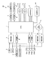
本発明の一実施の形態にかかる坂道検出方法、及び、坂道検出装置を、図1乃至図14を参照して説明する。図1は、本発明の一実施の形態に係る坂道検出装置20の基本構成図である。同図に示すように、坂道検出装置20内には、CPU1と、EEPROM2と、気圧データとしての気圧Pを測定する気圧センサ3と、第1加速度Gcを測定する加速度センサ14と、電源回路4と、IGN(イグニッション)5と、入力I/F回路6と、車速パルス7と、出力I/F回路8、9と、上り信号モニタ10と、下り信号モニタ11と、ダイヤル12、13と、が備えられている。
A slope detection method and a slope detection apparatus according to an embodiment of the present invention will be described with reference to FIGS. FIG. 1 is a basic configuration diagram of a
上記CPU1は、電源回路4を介してIGN(イグニッション)5からON信号が入力されて、移動体としての車両Cが走行すると、該CPU1には、入力I/F回路6を介して、車速パルス7が供給される。また、CPU1は、走行中の路面が坂道と判定された際に坂道信号を、出力I/F回路8、9を介して、信号モニタ10、11に出力している。
When the ON signal is input from the IGN (ignition) 5 through the power supply circuit 4 and the vehicle C as a moving body travels, the
上記EEPROM2は、前記CPU1が行う処理プログラムなどを格納したプログラム格納エリアと、前記CPU1での各種の処理過程で利用するワークエリア、各種データを格納するデータ格納エリアと、を有し、読み出し書き込み自在に設けられている。
The EEPROM 2 has a program storage area that stores a processing program executed by the
上記気圧センサ3は、走行中の車両C周辺の気圧Pを測定する。気圧Pは、ワークエリアに順次格納される。また、気圧センサ3によって測定された気圧Pを用いて、後述する高度値Hが算出される。また、本実施形態では、前記気圧Pは、約0.5秒間隔で測定されている。 The atmospheric pressure sensor 3 measures the atmospheric pressure P around the traveling vehicle C. The atmospheric pressure P is sequentially stored in the work area. Further, an altitude value H described later is calculated using the atmospheric pressure P measured by the atmospheric pressure sensor 3. In the present embodiment, the atmospheric pressure P is measured at intervals of about 0.5 seconds.
上記加速度センサ14は、移動体としての車両Cの進行方向に当該車両Cに加わる加速度としての第1加速度Gc(n)を測定している。この第1加速度Gc(n)は、図3に示すように、移動体としての車両Cの進行方向の移動に伴う第2加速度Gb(n)と、重力加速度Gの移動体としての車両Cの進行方向成分の加速度Ga(n)と、がベクトル的に加算された値である。
The
上記ダイヤル12、13は、前記車両Cが走行中の路面が勾配であるか否かを判定する際の閾値を設定している。また、本実施形態では、前記閾値を2.5%に設定している。 The dials 12 and 13 set a threshold value for determining whether or not the road surface on which the vehicle C is traveling is a slope. In the present embodiment, the threshold value is set to 2.5%.
上述した構成の坂道検出装置20が坂道検出する手順について説明する。
A procedure for detecting the slope by the
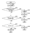
図2は、本発明の一実施の形態における坂道検出装置20が坂道を検出処理する処理手順を示すフローチャートである。
FIG. 2 is a flowchart showing a processing procedure in which the
はじめに、CPU1は、速度信号入力処理(ステップS101)を行う。CPU1は、速度信号入力処理(ステップS101)では、車速パルス7をカウントする。
First, the
次に、CPU1は、時間計測処理(ステップS102)を行う。時間計測処理(ステップS102)では、車速パルス7を、所定のカウント数までカウントする。そして、所定のカウント数の車速パルス7がカウントされるのにかかった時間を計測する。即ち、車両Cが、所定のカウント数(即ち、単位走行距離)走行するためにかかった時間を計測する。そして、計測した時間を、データ格納エリアに順次格納する。また、本実施形態では、所定のカウント数(即ち、単位走行距離)は、50mとする。
Next, the
次に、CPU1は、気圧データ入手処理(ステップS103)を行う。気圧データ入手処理(ステップS103)では、時間計測処理(ステップS102)が終了した地点(即ち、単位走行距離地点Ln)の前記気圧Pを、前記ワークエリアから取得する。
Next, the
次に、CPU1は、高度算出手段として働き、高度算出処理(ステップS104)を行う。高度算出処理(ステップS104)では、気圧データ入手処理(ステップS103)にて取得した、前記気圧Pを用いて、高度値Hを算出する。前記高度値Hは、下記に示す式により一意に算出される。なお、高度値Hを算出する際に用いられる気圧Pは、数回分の気圧Pの平均値を用いてもよい。
高度値H=44.33km×[1−(P/101325Pa)0.19]
Next, the
Altitude H = 44.33 km × [1− (P / 101325 Pa) 0.19 ]
また、算出された高度値Hは、出発地点L0の高度値H0とし、1回目の単位走行距離地点L1の高度値H1とし、2回目の単位走行距離地点L2の高度値H2とし、n回目(今回)の単位走行距離地点Lnの高度値Hnとし、次(n+1)の単位走行距離地点L(n+1)の高度値H(n+1)としてデータ格納エリアに順次格納される。 The calculated altitude value H is the altitude value H0 of the departure point L0, the altitude value H1 of the first unit travel distance point L1, the altitude value H2 of the second unit travel distance point L2, and the nth ( The altitude value Hn of the current unit travel distance point Ln and the altitude value H (n + 1) of the next (n + 1) unit travel distance point L (n + 1) are sequentially stored in the data storage area.
さらに、高度算出処理(ステップS104)では、n回目(今回)の単位走行距離地点Lnの高度値Hnから、n−1回目(前回)の単位走行距離地点L(n−1)の高度値H(n−1)を減算することで高度差Aを算出する。また、算出された高度差Aは、データ格納エリアに順次格納される。 Further, in the altitude calculation process (step S104), from the altitude value Hn of the nth (current) unit travel distance point Ln, the altitude value H of the n-1th (previous) unit travel distance point L (n-1). The altitude difference A is calculated by subtracting (n-1). The calculated altitude difference A is sequentially stored in the data storage area.
次に、CPU1は、加速度算出手段として働き、加速度算出処理(ステップS105)を行う。加速度算出処理(ステップS105)では、第1加速度Gcn(図3に示す)を測定する。さらに、時間計測処理(ステップS102)においてデータ格納エリアに格納された、車両Cが単位走行距離(50m)を走行するためにかかった「時間」で2回微分することにより、車両Cの進行方向の移動に伴う第2加速度Gbnを算出する。そして、単位走行距離地点Lnの第1加速度Gcnと第2加速度Gbnとを、データ格納エリアに格納する。また、第1加速度Gcnから第2加速度Gbnをベクトル的に減算することで、重力加速度Gの移動体としての車両Cの進行方向成分の加速度Gan(図3に示す)を算出する。この加速度Ganが、所定値Zより大きければ、車両Cが走行中の路面は、「勾配」と判定される。本実施形態では前記所定値Zは、ゼロに設定されている。
Next, the
次に、CPU1は、勾配判定処理(ステップS106)を行う。坂道検出装置20では、勾配と判定する閾値を2.5%に設定されているので、勾配と判定される高度差Kは、2.5(%)×50(m)=1.25(m)となる。また、高度算出処理(ステップS104)にて算出された単位走行距離あたりの高度差Aが、+1.25m以上である場合であり、かつ、加速度算出処理(ステップS105)にて算出された加速度Ganが所定値Zより大きい場合、この勾配は「上り勾配」であると判定される。そして、上りまたは下りの勾配が2.5%に満たない場合、または、加速度Ganが所定値Z以下である場合は、勾配ではないと判定される。また、前記高度差Kは、特許請求項の範囲に示された「所定の高度差」に相当する。
Next, the
また、本坂道検出装置20では、3回連続して同一方向への勾配であった場合に、坂道であると判定される。例えば、勾配が、上りー上りー上りである場合に「上り坂」であると判定される、また、勾配が、下りー下りー下りである場合に「下り坂」であると判定される。
Moreover, in this
図4は、図2に示された勾配判定処理(ステップS106)の詳細手順を示すフローチャートである。はじめに、CPU1は、高度差A>ゼロであるか否かの判定を行う(ステップ201)。上記条件を満足する場合(ステップS201のYES)は、ステップS202に進み、上記条件を満足しない場合(ステップS201のNO)は、ステップS222に進む。
FIG. 4 is a flowchart showing a detailed procedure of the gradient determination process (step S106) shown in FIG. First, the
次に、CPU1は、高度差A≧高度差K、かつ、第1加速度Gcn−第2加速度Gbn>Z、であるか否かの判定を行う(ステップS202)。上記条件を満足する場合(ステップS202のYES)、即ち、走行中の路面が上り勾配であると判定された場合は、上り勾配の連続数を示す「上りカウント」を+1とする(ステップS203)。また、上記条件を満足しない場合(ステップS202のNO)、即ち、走行中の路面が上り勾配ではないと判定された場合は、次(n+1)の単位走行距離地点L(n+1)の高度値H(n+1)、及び、加速度Gc(n+1)、Gb(n+1)を取得(ステップS205)して、S201に進む。
Next, the
次に、CPU1は、上りカウント≧2であるか否かの判定を行う(ステップS204)。上記条件を満足する場合(ステップS204のYES)、さらに、上りカウント=2であるか否かの判定を行う(ステップS206)。上記条件を満足する場合(ステップS206のYES)、即ち、上りカウント=2である場合、次(n+1)の単位走行距離地点L(n+1)の高度値H(n+1)、及び、加速度Gc(n+1)、Gb(n+1)を取得(ステップS207)して、ステップS208に進む。
Next, the
次に、CPU1は、高度差A≧高度差K、かつ、第1加速度Gcn−第2加速度Gbn>Z、であるか否かの判定を行う(ステップS208)。上記条件を満足する場合(ステップS208のYES)、上り信号モニタ10に、上り坂道信号を出力する(ステップS209)。そして、上りカウントをゼロクリアして(ステップS211)、次(n+1)の単位走行距離地点L(n+1)の高度値H(n+1)、及び、加速度Gc(n+1)、Gb(n+1)を取得(ステップS212)する。
Next, the
また、上記条件を満足しない場合(ステップS208のNO)は、CPU1は、次の単位走行距離地点L(n+1)のモニタリング(ステップS210)に進む。次の単位走行距離地点L(n+1)のモニタリング(ステップS210)は、上り勾配が2回連続した直後の1回(3回目)の単位走行距離地点L3が上り勾配と判定されなかった場合に、上り坂道信号の出力を停止するのではなく、算出された高度値H3がノイズである可能性を考慮して、次(4回目)の単位走行距離地点L4を、モニタリングすることで、精度の高い坂道判定を行うためのものである。
If the above condition is not satisfied (NO in step S208), the
また、上りカウント≧2において否の場合(ステップS204のNO)、即ち、上りカウントが1の場合は、次(n+1)の単位走行距離地点L(n+1)の高度値H(n+1)、及び、加速度Gc(n+1)、Gb(n+1)を取得(ステップS205)して、S201に進む。 Further, if the up count is not 2 (NO in step S204), that is, if the up count is 1, the altitude value H (n + 1) of the next (n + 1) unit travel distance point L (n + 1), and The accelerations Gc (n + 1) and Gb (n + 1) are acquired (step S205), and the process proceeds to S201.
また、上りカウント=2において否の場合(ステップS206のNO)、即ち、上りカウントが3の場合は、3回連続して上り方向への勾配であったと判断されることとなり、車両Cが走行中の路面は、「上り坂道」であると判定されて、上り信号モニタ10に、上り坂道信号を出力する(ステップS209)。 Further, if the up count is 2 (NO in step S206), that is, if the up count is 3, it is determined that the slope is in the up direction three times in succession, and the vehicle C travels. The inside road surface is determined to be “uphill”, and an uphill signal is output to the uphill signal monitor 10 (step S209).
図5は、次の単位走行距離地点L(n+1)のモニタリング(ステップS210)の処理手順を示すフローチャートである。まず、次(n+1)の単位走行距離地点L(n+1)の高度値H(n+1)、即ち、4回目の単位走行距離地点L4の高度値H4、及び、加速度Gc4、Gb4を取得(ステップS301)した後、ステップS302に進む。 FIG. 5 is a flowchart showing a processing procedure for monitoring (step S210) of the next unit travel distance point L (n + 1). First, an altitude value H (n + 1) of the next (n + 1) unit travel distance point L (n + 1), that is, an altitude value H4 of the fourth unit travel distance point L4 and accelerations Gc4 and Gb4 are acquired (step S301). After that, the process proceeds to step S302.
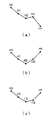
ステップS302においては、高度値H4−高度値H2>ゼロ、かつ、高度値H4−高度値H3>ゼロ、かつ、高度値H4−高度値H1≧高度差K×3、かつ、第1加速度Gc4−第2加速度Gb4>Zであるか否かの判定を行う。上記条件を満足する場合(ステップS302のYES)、上り信号モニタ10に、上り坂道信号を出力する(ステップS303)。図6は、単位走行距離毎の高度変化例を模式的に示した図である。図6(a)は、上記の走行状況を示している。即ち、3回目の単位走行距離地点L3は、「上り」勾配ではなかったが、4回目の単位走行距離地点L4は、「上り」勾配であり、過去3回分の高度差Aの合計が、高度差Kの3倍以上であり、かつ、第1加速度Gc4−第2加速度Gb4>Zであるため「上り坂道」と判定した。そして、上り信号モニタ10に、上り坂道信号を出力した(ステップS303)後、上りカウントをゼロクリアして(ステップS304)、図5に示された次の単位走行距離地点L(n+1)のモニタリング(ステップS210)を終了し、図4のフローチャートに戻る。 In step S302, the altitude value H4−the altitude value H2> zero, the altitude value H4−the altitude value H3> zero, the altitude value H4−the altitude value H1 ≧ the altitude difference K × 3, and the first acceleration Gc4−. It is determined whether or not the second acceleration Gb4> Z. If the above condition is satisfied (YES in step S302), an uphill signal is output to the up signal monitor 10 (step S303). FIG. 6 is a diagram schematically illustrating an altitude change example for each unit travel distance. FIG. 6A shows the traveling state described above. That is, the third unit mileage point L3 was not an “uphill” gradient, but the fourth unit mileage point L4 was an “uphill” gradient, and the total of the altitude differences A for the past three times is the altitude. Since the difference K is three times or more of the difference K and the first acceleration Gc4−the second acceleration Gb4> Z, it is determined as “uphill”. Then, after an uphill signal is output to the up signal monitor 10 (step S303), the up count is cleared to zero (step S304), and the next unit travel distance point L (n + 1) shown in FIG. Step S210) is terminated, and the process returns to the flowchart of FIG.
上記条件を満たさない場合(ステップS302のNO)、|高度値H3−高度値H2|≧高度差K、かつ、|高度値H4−高度値H3|≧高度差Kであるか否かを判定する(ステップS305)。ステップS305は、絶対値による判定を行っている。これは、車両Cが走行中の路面が、単位走行距離地点L3、または、単位走行距離地点L4において、下り勾配であるか否かを判定するためである。 If the above condition is not satisfied (NO in step S302), it is determined whether or not | altitude value H3−altitude value H2 | ≧ altitude difference K and | altitude value H4−altitude value H3 | ≧ altitude difference K. (Step S305). In step S305, determination based on an absolute value is performed. This is to determine whether the road surface on which the vehicle C is traveling is a downward slope at the unit travel distance point L3 or the unit travel distance point L4.
上記条件を満足する場合(ステップS305のYES)、CPU1は、下りカウント=2とする(ステップS306)。図6(b)は、上記の走行状況を示している。即ち、2回連続して「上り」勾配が続いたが、その後、3回目、4回目は連続して「下り」勾配と判定されたため、下りカウント=2(ステップS306)として、図5に示された次の単位走行距離地点L(n+1)のモニタリング(ステップS210)を終了し、図4のフローチャートに戻る。
When the above condition is satisfied (YES in step S305), the
上記条件を満たさない場合(ステップS305のNO)、|高度値H4−高度値H3|≧高度差Kであるか否かを判定する(ステップS307)。 If the above condition is not satisfied (NO in step S305), it is determined whether or not | altitude value H4−altitude value H3 | ≧ altitude difference K (step S307).
上記条件を満足する場合(ステップS307のYES)、CPU1は、下りカウント=1とする(ステップS308)。図6(c)は、上記の走行状況を示している。即ち、2回連続して「上り」勾配が続いたが、その後3回目は、高度値H3と高度値H2との高度差Aが高度差Kより小さいため勾配と判定されず、次の4回目は「下り」の勾配と判定されたため、下りカウント=1(ステップS308)として、図5に示された次の単位走行距離地点L(n+1)のモニタリング(ステップS210)を終了し、図4のフローチャートに戻る。
If the above condition is satisfied (YES in step S307), the
上記条件を満たさない場合(ステップS307のNO)、2回連続して「上り」勾配が続いたが、その後、高度値H3と高度値H2との高度差A、及び、高度値H4と高度値H3との高度差Aが、高度差Kより小さいため勾配と判定されず、上りカウントをゼロクリア(ステップS309)して、図5に示された次の単位走行距離地点L(n+1)のモニタリング(ステップS210)を終了し、図4のフローチャートに戻る。 When the above condition is not satisfied (NO in step S307), the “up” gradient continued twice, but thereafter, the altitude difference A between the altitude value H3 and the altitude value H2, and the altitude value H4 and the altitude value Since the altitude difference A with respect to H3 is smaller than the altitude difference K, it is not determined to be a gradient, the up-count is cleared to zero (step S309), and the next unit travel distance point L (n + 1) shown in FIG. Step S210) is terminated, and the process returns to the flowchart of FIG.
図4のフローチャートに戻り、次(n+1)の単位走行距離地点L(n+1)の高度値H(n+1)、及び、加速度Gc(n+1)、Gb(n+1)を取得(ステップS212)して、図4に示された勾配判定処理(ステップS106)を終了し、図2のフローチャートに戻る。 Returning to the flowchart of FIG. 4, the altitude value H (n + 1) and accelerations Gc (n + 1) and Gb (n + 1) of the next (n + 1) unit travel distance point L (n + 1) are acquired (step S212). 4 is finished, and the process returns to the flowchart of FIG.
一方、図4に示すステップS201において、上記条件を満足しない場合(ステップS201のNO)、さらに、CPU1は、|高度差A|≧高度差K、かつ、|第1加速度Gcn−第2加速度Gbn|>Z、であるか否かの判定を行う(ステップS222)。ステップS222においては、絶対値で判定を行っている。これは、下り勾配の高度差A、及び、第1加速度Gcn−第2加速度Gbn(即ち、加速度Gan)、が、負の値である場合において、判定を行うためである。
On the other hand, when the above condition is not satisfied in step S201 shown in FIG. 4 (NO in step S201), the
上記条件を満足する場合(ステップS222のYES)、即ち、走行中の路面が下り勾配であると判定された場合は、下り勾配の連続数を示す「下りカウント」を+1とする(ステップS223)。また、上記条件を満足しない場合(ステップS222のNO)、即ち、走行中の路面が下り勾配ではないと判定された場合は、次(n+1)の単位走行距離地点L(n+1)の高度値H(n+1)、及び、加速度Gc(n+1)、Gb(n+1)を取得(ステップS225)して、S201に進む。 If the above condition is satisfied (YES in step S222), that is, if it is determined that the traveling road surface has a downward slope, the “downward count” indicating the continuous number of downward slopes is set to +1 (step S223). . If the above condition is not satisfied (NO in step S222), that is, if it is determined that the road surface being traveled is not a downward slope, the altitude value H of the next (n + 1) unit travel distance point L (n + 1) (N + 1) and accelerations Gc (n + 1) and Gb (n + 1) are acquired (step S225), and the process proceeds to S201.
次に、CPU1は、下りカウント≧2であるか否かの判定を行う(ステップS224)。上記条件を満足する場合(ステップS224のYES)、さらに、下りカウント=2であるか否かの判定を行う(ステップS226)。上記条件を満足する場合(ステップS226のYES)、即ち、下りカウント=2である場合、次(n+1)の単位走行距離地点L(n+1)の高度値H(n+1)、及び、加速度Gc(n+1)、Gb(n+1)を取得(ステップS227)して、ステップS233に進む。
Next, the
ステップS233では、高度差A>ゼロであるか否かの判定を行う。上記条件を満足する場合(ステップS233のYES)は、ステップS230に進み、上記条件を満足しない場合(ステップS228のNO)は、ステップS228に進む。 In step S233, it is determined whether the altitude difference A> zero. If the above condition is satisfied (YES in step S233), the process proceeds to step S230. If the above condition is not satisfied (NO in step S228), the process proceeds to step S228.
次に、CPU1は、|高度差A|≧高度差K、かつ、|第1加速度Gcn−第2加速度Gbn|>Z、であるか否かの判定を行う(ステップS228)。上記条件を満足する場合(ステップS228のYES)、下り信号モニタ11に、下り坂道信号を出力する(ステップS229)。そして、下りカウントをゼロクリアして(ステップS211)、次(n+1)の単位走行距離地点L(n+1)の高度値H(n+1)、及び、加速度Gc(n+1)、Gb(n+1)を取得(ステップS232)する。
Next, the
また、上記条件を満足しない場合(ステップS228のNO)は、CPU1は、次の単位走行距離地点L(n+1)のモニタリング(ステップS230)に進む。次の単位走行距離地点L(n+1)のモニタリング(ステップS230)は、下り勾配が2回連続した直後の1回(3回目)の単位走行距離地点L3が下り勾配と判定されなかった場合に、下り坂道信号の出力を停止するのではなく、算出された高度値H3がノイズである可能性を考慮して、次(4回目)の単位走行距離地点L4を、モニタリングすることで、精度の高い坂道判定を行うためのものである。
If the above condition is not satisfied (NO in step S228), the
また、下りカウント≧2において否の場合(ステップS224のNO)、即ち、下りカウントが1の場合は、次(n+1)の単位走行距離地点L(n+1)の高度値H(n+1)、及び、加速度Gc(n+1)、Gb(n+1)を取得(ステップS225)して、S201に進む。 Further, if the downcount ≧ 2 is negative (NO in step S224), that is, if the downcount is 1, the altitude value H (n + 1) of the next (n + 1) unit travel distance point L (n + 1), and The accelerations Gc (n + 1) and Gb (n + 1) are acquired (step S225), and the process proceeds to S201.
また、下りカウント=2において否の場合(ステップS226のNO)、即ち、下りカウントが3の場合は、3回連続して下り方向への勾配であったと判断されることとなり、車両Cが走行中の路面は、「下り坂道」であると判定されて、下り信号モニタ11に、下り坂道信号を出力する(ステップS229)。 In addition, if the downcount = 2 is negative (NO in step S226), that is, if the downcount is 3, it is determined that the slope is in the downward direction three times in succession, and the vehicle C travels. The inside road surface is determined to be “downhill”, and a downhill signal is output to the down signal monitor 11 (step S229).
図7は、次の単位走行距離地点L(n+1)のモニタリング(ステップS230)の処理手順を示すフローチャートである。まず、次(n+1)の単位走行距離地点L(n+1)の高度値H(n+1)、即ち、4回目の単位走行距離地点L4の高度値H4、及び、加速度Gc4、Gb4を取得(ステップS311)した後、ステップS319に進む。 FIG. 7 is a flowchart showing a processing procedure for monitoring the next unit travel distance point L (n + 1) (step S230). First, an altitude value H (n + 1) of the next (n + 1) unit travel distance point L (n + 1), that is, an altitude value H4 of the fourth unit travel distance point L4 and accelerations Gc4 and Gb4 are acquired (step S311). Then, the process proceeds to step S319.
ステップS319では、高度差A>ゼロであるか否かの判定を行う。上記条件を満足する場合(ステップS319のYES)は、ステップS315に進み、上記条件を満足しない場合(ステップS319のNO)は、ステップS312に進む。 In step S319, it is determined whether or not the altitude difference A> zero. If the above condition is satisfied (YES in step S319), the process proceeds to step S315. If the above condition is not satisfied (NO in step S319), the process proceeds to step S312.
ステップS312においては、|高度値H4−高度値H2|>ゼロ、かつ、|高度値H4−高度値H3|>ゼロ、かつ、|高度値H4−高度値H1|≧高度差K×3、かつ、|第1加速度Gc4−第2加速度Gb4|>Zであるか否かの判定を行う。上記条件を満足する場合(ステップS312のYES)、下り信号モニタ11に、下り坂道信号を出力する(ステップS313)。図8は、単位走行距離毎の高度変化例を模式的に示した図である。図8(a)は、上記の走行状況を示している。即ち、3回目の単位走行距離地点L3は、「下り」勾配ではなかったが、4回目の単位走行距離地点L4は、「下り」勾配であり、過去3回分の高度差Aの合計が、高度差Kの3倍以上であり、かつ、|第1加速度Gc4−第2加速度Gb4|>Zであるため「下り坂道」と判定した。そして、下り信号モニタ11に、下り坂道信号を出力した(ステップS313)後、下りカウントをゼロクリアして(ステップS314)、図7に示された次の単位走行距離地点L(n+1)のモニタリング(ステップS230)を終了し、図4のフローチャートに戻る。 In step S312, | altitude value H4−altitude value H2 |> zero, | altitude value H4−altitude value H3 |> zero, and | altitude value H4−altitude value H1 | ≧ altitude difference K × 3, and , | First acceleration Gc4−second acceleration Gb4 |> Z is determined. If the above condition is satisfied (YES in step S312), a downhill signal is output to the down signal monitor 11 (step S313). FIG. 8 is a diagram schematically illustrating an altitude change example for each unit travel distance. FIG. 8A shows the traveling state described above. That is, the third unit travel distance point L3 was not a “downhill” gradient, but the fourth unit travel distance point L4 was a “downhill” gradient, and the total of the altitude differences A for the past three times is the altitude. Since the difference is more than three times the difference K and | first acceleration Gc4−second acceleration Gb4 |> Z, it is determined as “downhill”. Then, after outputting a downhill signal to the down signal monitor 11 (step S313), the down count is cleared to zero (step S314), and the next unit travel distance point L (n + 1) shown in FIG. Step S230) is terminated, and the process returns to the flowchart of FIG.
上記条件を満たさない場合(ステップS312のNO)、|高度値H3−高度値H2|≧高度差K、かつ、|高度値H4−高度値H3|≧高度差Kであるか否かを判定する(ステップS315)。上記条件を満足する場合(ステップS315のYES)、CPU1は、下りカウント=2とする(ステップS316)。図8(b)は、上記の走行状況を示している。即ち、2回連続して「下り」勾配が続いたが、その後、3回目、4回目は連続して「下り」勾配と判定されたため、下りカウント=2(ステップS316)として、図7に示された次の単位走行距離地点L(n+1)のモニタリング(ステップS230)を終了し、図4のフローチャートに戻る。
If the above condition is not satisfied (NO in step S312), it is determined whether or not | altitude value H3−altitude value H2 | ≧ altitude difference K and | altitude value H4−altitude value H3 | ≧ altitude difference K. (Step S315). When the above condition is satisfied (YES in step S315), the
上記条件を満たさない場合(ステップS315のNO)、|高度値H4−高度値H3|≧高度差Kであるか否かを判定する(ステップS317)。 If the above condition is not satisfied (NO in step S315), it is determined whether or not | altitude value H4−altitude value H3 | ≧ altitude difference K (step S317).
上記条件を満足する場合(ステップS317のYES)、CPU1は、下りカウント=1とする(ステップS318)。図8(c)は、上記の走行状況を示している。即ち、2回連続して「下り」勾配が続いたが、その後3回目は、高度値H3と高度値H2との高度差Aが高度差Kより小さいため勾配と判定されず、次の4回目は「下り」の勾配と判定されたため、下りカウント=1(ステップS318)として、図7に示された次の単位走行距離地点L(n+1)のモニタリング(ステップS230)を終了し、図4のフローチャートに戻る。
When the above condition is satisfied (YES in step S317), the
上記条件を満たさない場合(ステップS317のNO)、2回連続して「下り」勾配が続いたが、その後3回目、4回目は、高度値H3と高度値H2との高度差A、及び、高度値H4と高度値H3との高度差Aが、高度差Kより小さいため勾配と判定されず、下りカウントをゼロクリア(ステップS314)して、図7に示された次の単位走行距離地点L(n+1)のモニタリング(ステップS230)を終了し、図4のフローチャートに戻る。 When the above condition is not satisfied (NO in step S317), the “downward” gradient continued twice, but the third time and the fourth time are the height difference A between the height value H3 and the height value H2, and Since the altitude difference A between the altitude value H4 and the altitude value H3 is smaller than the altitude difference K, it is not determined as a gradient, the downcount is cleared to zero (step S314), and the next unit travel distance point L shown in FIG. Monitoring of (n + 1) (step S230) is terminated, and the process returns to the flowchart of FIG.
図4のフローチャートに戻り、次(n+1)の単位走行距離地点L(n+1)の高度値H(n+1)、及び、加速度Gc(n+1)、Gb(n+1)を取得(ステップS232)して、図4に示された勾配判定処理(ステップS106)を終了し、図2のフローチャートに戻る。 Returning to the flowchart of FIG. 4, the altitude value H (n + 1) and accelerations Gc (n + 1) and Gb (n + 1) of the next (n + 1) unit travel distance point L (n + 1) are acquired (step S232). 4 is finished, and the process returns to the flowchart of FIG.
図2のフローチャートに戻り、勾配判定処理(ステップS106)によって同一方向への勾配が3回以上連続した場合、上りまたは下り坂道信号が出力されるが、その後、坂道が継続されるか否かは、坂道判定処理(ステップS107)によって行われる。 Returning to the flowchart of FIG. 2, when the gradient determination process (step S106) causes the gradient in the same direction to continue three or more times, an up or down slope signal is output. This is performed by the slope judgment process (step S107).
次に、CPU1は、坂道判定手段として働き、坂道判定処理(ステップS107)を行う。図9は、坂道判定処理(ステップS107)の詳細手順を示すフローチャートである。はじめに、CPU1は、高度差A>ゼロであるか否かの判定を行う(ステップ501)。上記条件を満足する場合(ステップS501のYES)は、ステップS502に進み、上記条件を満足しない場合(ステップS501のNO)は、ステップS522に進む。
Next, the
次に、CPU1は、高度差A≧高度差K、かつ、第1加速度Gcn−第2加速度Gbn>Z、であるか否かの判定を行う(ステップS502)。上記条件を満足する場合(ステップS502のYES)、さらに、CPU1は、現在、上り坂道信号が出力中であるか否かを判定し(ステップS503)、上記条件を満足する場合(ステップS503のYES)、即ち、上り坂道信号が出力中であれば、そのまま上り坂道信号の出力を継続し、次(n+1)の単位走行距離地点L(n+1)の高度値H(n+1)、及び、加速度Gc(n+1)、Gb(n+1)を取得(ステップS504)して、S501に進む。
Next, the
上記条件を満たさない場合(ステップS502のNO)、即ち、走行中の路面が上り勾配ではないと判定された場合は、さらに、CPU1は、現在、上り坂道信号が出力中であるか否かを判定し(ステップS508)、上記条件を満足する場合(ステップS508のYES)、即ち、上り坂道信号が出力中であれば、CPU1は、次の単位走行距離地点L(n+1)のモニタリング(ステップS509)に進む。
If the above condition is not satisfied (NO in step S502), that is, if it is determined that the traveling road surface is not an uphill slope, the
上記条件を満たさない場合(ステップS508のNO)、即ち、上り坂道信号が出力中でない場合は、次(n+1)の単位走行距離地点L(n+1)の高度値H(n+1)、及び、加速度Gc(n+1)、Gb(n+1)を取得(ステップS504)して、S501に進む。 When the above condition is not satisfied (NO in step S508), that is, when the uphill signal is not being output, the altitude value H (n + 1) of the next (n + 1) unit travel distance point L (n + 1) and the acceleration Gc (N + 1) and Gb (n + 1) are acquired (step S504), and the process proceeds to S501.
また、上り坂道信号が出力中でない場合は、(ステップS503のNO)さらに、CPU1は、下り坂道信号が出力中であるか否かを判定し(ステップS505)、上記条件を満足する場合(ステップS505のYES)、即ち、下り坂道信号が出力中であれば、次の単位走行距離地点L(n+1)のモニタリング(ステップS529)に進む(図9中の「B」ポイントに移行する)。
If the uphill signal is not being output (NO in step S503), the
上記条件を満たさない場合(ステップS505のNO)、即ち、下り坂道信号が出力中でない場合は、上り勾配の連続数を示す「上りカウント」を+1として(ステップS506)、図4のS204に進む(図4中の「A」ポイントに移行する)。 When the above condition is not satisfied (NO in step S505), that is, when the downhill signal is not being output, “upcount” indicating the number of consecutive uphills is set to +1 (step S506), and the process proceeds to S204 in FIG. (Transition to “A” point in FIG. 4).
図10は、次の単位走行距離地点L(n+1)のモニタリング(ステップS509)の処理手順を示すフローチャートである。図9に示すステップS502において、今回(7回目)の単位走行距離地点L7が、勾配と判定されなかったので、ステップS509に進み、次(8回目)の単位走行距離地点L8の高度値H8、及び、加速度Gc8、Gc8と、を取得(ステップS601)した後、ステップS602に進む。 FIG. 10 is a flowchart showing a processing procedure for monitoring the next unit travel distance point L (n + 1) (step S509). In step S502 shown in FIG. 9, since the current (seventh) unit travel distance point L7 is not determined to be a gradient, the process proceeds to step S509, and the altitude value H8 of the next (eighth) unit travel distance point L8, And after acquiring acceleration Gc8, Gc8 (step S601), it progresses to step S602.
ステップS602においては、高度値H8−高度値H6>ゼロ、かつ、高度値H8−高度値H7>ゼロ、かつ、高度値H8−高度値H5≧高度差K×3、かつ、第1加速度Gc8−第2加速度Gb8>Zであるか否かの判定を行う。上記条件を満足する場合(ステップS602のYES)、上り信号モニタ10に、上り坂道信号を出力する(ステップS603)。図11は、単位走行距離毎の高度変化例を模式的に示した図である。図11(a)は、上記の走行状況を示している。即ち、7回目の単位走行距離地点L7は、「上り」勾配ではなかったが、8回目の単位走行距離地点L8は、「上り」勾配であり、過去3回分の高度差Aの合計が、高度差Kの3倍以上であり、かつ、第1加速度Gc8−第2加速度Gb8>Zであるため「上り坂道」と判定した。そして、上り信号モニタ10に、上り坂道信号を出力した(ステップS603)後、上りカウントをゼロクリアして(ステップS610)、図10に示された次の単位走行距離地点L(n+1)のモニタリング(ステップS509)を終了し、図9のフローチャートに戻る。 In step S602, altitude value H8−altitude value H6> zero, altitude value H8−altitude value H7> zero, altitude value H8−altitude value H5 ≧ altitude difference K × 3, and first acceleration Gc8− It is determined whether or not the second acceleration Gb8> Z. If the above condition is satisfied (YES in step S602), an uphill signal is output to the up signal monitor 10 (step S603). FIG. 11 is a diagram schematically illustrating an altitude change example for each unit travel distance. FIG. 11A shows the traveling state described above. That is, the seventh unit mileage point L7 was not an “up” gradient, but the eighth unit mileage point L8 was an “up” gradient, and the total of the altitude differences A for the past three times is the altitude. Since the difference K is equal to or more than three times the difference K and the first acceleration Gc8−the second acceleration Gb8> Z, it is determined as “uphill”. Then, after the uphill signal is output to the up signal monitor 10 (step S603), the up count is cleared to zero (step S610), and the next unit travel distance point L (n + 1) shown in FIG. Step S509) is terminated, and the process returns to the flowchart of FIG.
上記条件を満たさない場合(ステップS602のNO)、上り坂道信号の出力を停止(ステップS604)。 If the above condition is not satisfied (NO in step S602), the output of the uphill road signal is stopped (step S604).
次に、|高度値H7−高度値H6|≧高度差K、かつ、|高度値H8−高度値H7|≧高度差Kであるか否かを判定する(ステップS605)。上記条件を満足する場合(ステップS605のYES)、CPU1は、下りカウント=2とする(ステップS606)。図11(b)は、上記の走行状況を示している。即ち、2回連続して「上り」勾配が続いたが、その後、7回目、8回目は連続して「下り」勾配と判定されたため、下りカウント=2(ステップS606)として、図10に示された次の単位走行距離地点L(n+1)のモニタリング(ステップS509)を終了し、図9のフローチャートに戻る。
Next, it is determined whether or not | altitude value H7−altitude value H6 | ≧ altitude difference K and | altitude value H8−altitude value H7 | ≧ altitude difference K (step S605). If the above condition is satisfied (YES in step S605), the
上記条件を満たさない場合(ステップS605のNO)、|高度値H8−高度値H7|≧高度差Kであるか否かを判定する(ステップS607)。 If the above condition is not satisfied (NO in step S605), it is determined whether or not | altitude value H8−altitude value H7 | ≧ altitude difference K (step S607).
上記条件を満足する場合(ステップS607のYES)、CPU1は、下りカウント=1とする(ステップS608)。図11(c)は、上記の走行状況を示している。即ち、2回連続して「上り」勾配が続いたが、その後7回目は、高度値H7と高度値H6との高度差Aが高度差Kより小さいため勾配と判定されず、次の8回目は「下り」の勾配と判定されたため、下りカウント=1(ステップS608)として、図10に示された次の単位走行距離地点L(n+1)のモニタリング(ステップS509)を終了し、図9のフローチャートに戻る。
If the above condition is satisfied (YES in step S607), the
上記条件を満たさない場合(ステップS607のNO)、2回連続して「上り」勾配が続いたが、その後7回目、8回目は、高度値H7と高度値H6との高度差A、及び、高度値H8と高度値H7との高度差Aが、高度差Kより小さいため勾配と判定されず、上りカウントをゼロクリア(ステップS609)して、図10に示された次の単位走行距離地点L(n+1)のモニタリング(ステップS509)を終了し、図9のフローチャートに戻る。 When the above condition is not satisfied (NO in step S607), the “up” gradient continued twice, but after that, the seventh time and the eighth time, the height difference A between the height value H7 and the height value H6, and Since the altitude difference A between the altitude value H8 and the altitude value H7 is smaller than the altitude difference K, it is not determined as a gradient, the up count is cleared to zero (step S609), and the next unit travel distance point L shown in FIG. The monitoring of (n + 1) (step S509) is terminated, and the process returns to the flowchart of FIG.
図9のフローチャートに戻り、次(n+1)の単位走行距離地点L(n+1)の高度値H(n+1)、及び、加速度Gc(n+1)、Gb(n+1)を取得(ステップS510)して、図9に示された坂道判定処理(ステップS107)を終了し、図2のフローチャートに戻る。 Returning to the flowchart of FIG. 9, the altitude value H (n + 1) and accelerations Gc (n + 1) and Gb (n + 1) of the next (n + 1) unit travel distance point L (n + 1) are acquired (step S510). 9 is finished, and the process returns to the flowchart of FIG.
一方、図9に示すステップS501において、上記条件を満足しない場合(ステップS501のNO)、さらに、CPU1は、|高度差A|≧高度差K、かつ、|第1加速度Gcn−第2加速度Gbn|>Z、であるか否かの判定を行う(ステップS522)。ステップS522においては、絶対値で判定を行っている。これは、下り勾配の高度差A、及び、第1加速度Gcn−第2加速度Gbn(即ち、加速度Gan)、が、負の値である場合において、判定を行うためである。
On the other hand, if the above condition is not satisfied in step S501 shown in FIG. 9 (NO in step S501), the
上記条件を満足する場合(ステップS522のYES)、上記条件を満足する場合(ステップS522のYES)、さらに、CPU1は、現在、下り坂道信号が出力中であるか否かを判定を行い(ステップS523)、上記条件を満足する場合(ステップS523のYES)、即ち、下り坂道信号が出力中であれば、そのまま下り坂道信号の出力を継続し、次(n+1)の単位走行距離地点L(n+1)の高度値H(n+1)、及び、加速度Gc(n+1)、Gb(n+1)を取得(ステップS524)して、S501に進む。
If the above condition is satisfied (YES in step S522), if the above condition is satisfied (YES in step S522), the
上記条件を満たさない場合(ステップS522のNO)、即ち、走行中の路面が下り勾配ではないと判定された場合は、さらに、CPU1は、現在、下り坂道信号が出力中であるか否かを判定し(ステップS528)、上記条件を満足する場合(ステップS528のYES)、即ち、下り坂道信号が出力中であれば、CPU1は、次の単位走行距離地点L(n+1)のモニタリング(ステップS529)に進む。
If the above condition is not satisfied (NO in step S522), that is, if it is determined that the road surface being traveled is not downhill, the
上記条件を満たさない場合(ステップS528のNO)、即ち、下り坂道信号が出力中でない場合は、次(n+1)の単位走行距離地点L(n+1)の高度値H(n+1)、及び、加速度Gc(n+1)、Gb(n+1)を取得(ステップS524)して、S501に進む。 When the above condition is not satisfied (NO in step S528), that is, when the downhill signal is not being output, the altitude value H (n + 1) of the next (n + 1) unit travel distance point L (n + 1) and the acceleration Gc (N + 1) and Gb (n + 1) are acquired (step S524), and the process proceeds to S501.
また、下り坂道信号が出力中でない場合は、(ステップS523のNO)さらに、CPU1は、上り坂道信号が出力中であるか否かを判定し(ステップS525)、上記条件を満足する場合(ステップS525のYES)、即ち、上り坂道信号が出力中であれば、次の単位走行距離地点L(n+1)のモニタリング(ステップS509)に進む(図9中の「D」ポイントに移行する)。
If the downhill signal is not being output (NO in step S523), the
上記条件を満たさない場合(ステップS525のNO)、即ち、上り坂道信号が出力中でない場合は、上り勾配の連続数を示す「下りカウント」を+1として(ステップS526)、図4のS224に進む(図4中の「C」ポイントに移行する)。 If the above condition is not satisfied (NO in step S525), that is, if an uphill signal is not being output, “downcount” indicating the number of consecutive uphills is set to +1 (step S526), and the process proceeds to S224 in FIG. (Transition to “C” point in FIG. 4).
図12は、次の単位走行距離地点L(n+1)のモニタリング(ステップS529)の処理手順を示すフローチャートである。図9に示すステップS522において、今回(7回目)の単位走行距離地点L7が、勾配と判定されなかったので、ステップS529に進み、次(8回目)の単位走行距離地点L8の高度値H8、及び、加速度Gc8、Gc8と、を取得(ステップS611)した後、ステップS620に進む。 FIG. 12 is a flowchart showing a processing procedure for monitoring the next unit travel distance point L (n + 1) (step S529). In step S522 shown in FIG. 9, the current (seventh) unit travel distance point L7 has not been determined to be a gradient, so the process proceeds to step S529, and the next (eighth) unit travel distance point L8 altitude value H8, And after acquiring acceleration Gc8, Gc8 (step S611), it progresses to step S620.
ステップS620では、高度差A>ゼロであるか否かの判定を行う。上記条件を満足する場合(ステップS620のYES)は、ステップS614に進み、上記条件を満足しない場合(ステップS620のNO)は、ステップS612に進む。 In step S620, it is determined whether or not altitude difference A> zero. If the above condition is satisfied (YES in step S620), the process proceeds to step S614. If the above condition is not satisfied (NO in step S620), the process proceeds to step S612.
ステップS612においては、|高度値H8−高度値H6|>ゼロ、かつ、|高度値H8−高度値H7|>ゼロ、かつ、|高度値H8−高度値H5|≧高度差K×3、かつ、|第1加速度Gc8−第2加速度Gb8|>Zであるか否かの判定を行う。上記条件を満足する場合(ステップS612のYES)、下り信号モニタ11に、下り坂道信号を出力する(ステップS613)。図13は、単位走行距離毎の高度変化例を模式的に示した図である。図13(a)は、上記の走行状況を示している。即ち、7回目の単位走行距離地点L7は、「下り」勾配ではなかったが、8回目の単位走行距離地点L8は、「下り」勾配であり、過去3回分の高度差Aの合計が、高度差Kの3倍以上であり、かつ、|第1加速度Gc8−第2加速度Gb8|>Zであるため「下り坂道」と判定した。そして、下り信号モニタ11に、下り坂道信号を出力した(ステップS613)後、下りカウントをゼロクリアして(ステップS614)、図12に示された次の単位走行距離地点L(n+1)のモニタリング(ステップS509)を終了し、図9のフローチャートに戻る。 In step S612, | altitude value H8−altitude value H6 |> zero, | altitude value H8−altitude value H7 |> zero, and | altitude value H8−altitude value H5 | ≧ altitude difference K × 3, and , | First acceleration Gc8−second acceleration Gb8 |> Z is determined. If the above condition is satisfied (YES in step S612), a downhill signal is output to the down signal monitor 11 (step S613). FIG. 13 is a diagram schematically illustrating an altitude change example for each unit travel distance. FIG. 13A shows the above-described traveling state. That is, the seventh unit mileage point L7 was not “downhill”, but the eighth unit mileage point L8 was “downhill”, and the total of the altitude differences A for the past three times is the altitude. Since the difference K is equal to or more than three times the difference K and | first acceleration Gc8−second acceleration Gb8 |> Z, it is determined as “downhill”. Then, after outputting a downhill signal to the down signal monitor 11 (step S613), the down count is cleared to zero (step S614), and the next unit travel distance point L (n + 1) shown in FIG. Step S509) is terminated, and the process returns to the flowchart of FIG.
上記条件を満たさない場合(ステップS612のNO)、下り坂道信号の出力を停止する(ステップS614)。 If the above condition is not satisfied (NO in step S612), the output of the downhill signal is stopped (step S614).
次に、|高度値H7−高度値H6|≧高度差K、かつ、|高度値H8−高度値H7|≧高度差Kであるか否かを判定する(ステップS615)。 Next, it is determined whether or not | altitude value H7−altitude value H6 | ≧ altitude difference K and | altitude value H8−altitude value H7 | ≧ altitude difference K (step S615).
ステップS615においては、|高度値H7−高度値H6|≧高度差K、かつ、|高度値H8−高度値H7|≧高度差Kであるか否かを判定する(ステップS615)。ステップS615は、絶対値による判定を行っている。これは、車両Cが走行中の路面が、単位走行距離地点L7、または、単位走行距離地点L8において、下り勾配であるか否かを判定するためである。 In step S615, it is determined whether or not | altitude value H7−altitude value H6 | ≧ altitude difference K and | altitude value H8−altitude value H7 | ≧ altitude difference K (step S615). In step S615, determination based on an absolute value is performed. This is to determine whether or not the road surface on which the vehicle C is traveling is a downward slope at the unit travel distance point L7 or the unit travel distance point L8.
上記条件を満足する場合(ステップS615のYES)、CPU1は、下りカウント=2とする(ステップS616)。図13(b)は、上記の走行状況を示している。即ち、2回連続して「下り」勾配が続いたが、その後、7回目、8回目は連続して「下り」勾配と判定されたため、下りカウント=2(ステップS616)として、図12に示された次の単位走行距離地点L(n+1)のモニタリング(ステップS529)を終了し、図9のフローチャートに戻る。
If the above condition is satisfied (YES in step S615), the
上記条件を満たさない場合(ステップS615のNO)、|高度値H8−高度値H7|≧高度差Kであるか否かを判定する(ステップS617)。 If the above condition is not satisfied (NO in step S615), it is determined whether or not | altitude value H8−altitude value H7 | ≧ altitude difference K (step S617).
上記条件を満足する場合(ステップS617のYES)、CPU1は、下りカウント=1とする(ステップS618)。図13(c)は、上記の走行状況を示している。即ち、2回連続して「下り」勾配が続いたが、その後7回目は、高度値H7と高度値H6との高度差Aが高度差Kより小さいため勾配と判定されず、次の8回目は「下り」の勾配と判定されたため、下りカウント=1(ステップS618)として、図12に示された次の単位走行距離地点L(n+1)のモニタリング(ステップS509)を終了し、図9のフローチャートに戻る。
When the above condition is satisfied (YES in step S617), the
上記条件を満たさない場合(ステップS617のNO)、2回連続して「下り」勾配が続いたが、その後7回目、8回目は、高度値H7と高度値H6との高度差A、及び、高度値H8と高度値H7との高度差Aが、高度差Kより小さいため勾配と判定されず、下りカウントをゼロクリア(ステップS619)して、図12に示された次の単位走行距離地点L(n+1)のモニタリング(ステップS529)を終了し、図9のフローチャートに戻る。 When the above condition is not satisfied (NO in step S617), the “downward” gradient continued twice, but after that, the seventh time and the eighth time, the height difference A between the height value H7 and the height value H6, and Since the altitude difference A between the altitude value H8 and the altitude value H7 is smaller than the altitude difference K, it is not determined as a gradient, the downcount is cleared to zero (step S619), and the next unit travel distance point L shown in FIG. The monitoring of (n + 1) (step S529) is terminated, and the process returns to the flowchart of FIG.
図9のフローチャートに戻り、次(n+1)の単位走行距離地点L(n+1)の高度値H(n+1)、及び、加速度Gc(n+1)、Gb(n+1)を取得(ステップS530)して、図9に示された坂道判定処理(ステップS107)を繰り返す。そして、図9に示された坂道判定処理(ステップS107)が終了すると、図2のフローチャートに戻る。 Returning to the flowchart of FIG. 9, the altitude value H (n + 1) and accelerations Gc (n + 1) and Gb (n + 1) of the next (n + 1) unit travel distance point L (n + 1) are acquired (step S530). 9 repeats the slope determination process (step S107). Then, when the slope determination process (step S107) shown in FIG. 9 is completed, the process returns to the flowchart of FIG.
図2のフローチャートに戻り、CPU1は、記録処理(ステップS108)を行う。ここでは、データ格納エリアに格納された、車両Cが、所定のカウント数(即ち、単位走行距離)走行するためにかかった時間、高度値Hn、高度差A、第1加速度Gcnと第2加速度Gbnとを、図示しないデジタコメモリカードに記録する。こうして、図2のフローチャートが終了する。
Returning to the flowchart of FIG. 2, the
上述した実施形態によれば、気圧センサ3から取得した気圧データPに基づいて、移動体としての車両Cが所定の単位走行距離を走行する毎の高度値Hを求める高度算出工程と、加速度センサ14から取得した前記車両Cの進行方向に当該車両Cに加わる加速度Gcに基づいて重力加速度Gの車両Cの進行方向成分の加速度Gaを求める加速度算出工程と、前記高度算出工程にて前記高度値Hから求めた高度の変化量としての高度差Aと、前記重力加速度Gの車両Cの進行方向成分の加速度Gaと、の双方に基づいて、走行中の路面が坂道であると判定する坂道判定工程と、を有しているので、地図情報を保持せずとも正確に坂道を検出することとなり、さらに、急激な気圧データの変化が測定された場合においても、正確に坂道を検出することとなり、よって、坂道検出精度の向上を図るとともに、前記地図情報を保持しないことでコストダウンを図った坂道検出方法を提供することができる。
According to the embodiment described above, the altitude calculation step for obtaining the altitude value H every time the vehicle C as the moving body travels the predetermined unit travel distance based on the atmospheric pressure data P acquired from the atmospheric pressure sensor 3, and the
また、前記高度の変化量としての高度差Aが、所定の高度差Kよりも大きいとともに、前記重力加速度Gの移動体の進行方向成分の加速度Gaが所定値Zよりも大きい場合、走行中の路面が坂道であると判定するので、地図情報を保持せずとも正確に坂道を検出することとなり、さらに、急激な気圧データの変化が測定された場合においても、正確に坂道を検出することとなり、よって、坂道検出精度の向上を図るとともに、前記地図情報を保持しないことでコストダウンを図ることができる。 Further, when the altitude difference A as the amount of change in altitude is larger than a predetermined altitude difference K and the acceleration Ga of the moving direction component of the gravitational acceleration G is larger than a predetermined value Z, Since the road surface is determined to be a slope, the slope is accurately detected without holding map information. Furthermore, even when a sudden change in atmospheric pressure data is measured, the slope is accurately detected. Therefore, it is possible to improve the slope detection accuracy and reduce the cost by not holding the map information.
また、気圧データPを測定する気圧センサ3と、前記気圧データPに基づいて、移動体としての車両Cが所定の単位走行距離を走行する毎の高度値Hを求める高度算出手段と、前記車両Cの進行方向に当該車両Cに加わる加速度Gcを測定する加速度センサ14と、前記車両Cの進行方向に当該車両Cに加わる前記加速度Gcに基づいて重力加速度Gの前記車両Cの進行方向成分の加速度Gaを求める加速度算出手段と、前記高度算出手段にて前記高度値Hから求めた高度の変化量としての高度差Aと、前記加速度算出手段にて求めた前記重力加速度Gの移動体の進行方向成分の加速度Gaと、の双方に基づいて、走行中の路面が坂道であると判定する坂道判定手段と、を有しているので、地図情報を保持せずとも正確に坂道を検出することとなり、さらに、急激な気圧データの変化が測定された場合においても、正確に坂道を検出することとなり、よって、坂道検出精度の向上を図るとともに、前記地図情報を保持しないことでコストダウンを図った坂道検出装置20を提供することができる。
Also, an atmospheric pressure sensor 3 for measuring atmospheric pressure data P, an altitude calculating means for obtaining an altitude value H every time a vehicle C as a moving body travels a predetermined unit travel distance based on the atmospheric pressure data P, and the vehicle The
また、前記高度の変化量としての高度差Aが、所定の高度差Kよりも大きいとともに、前記重力加速度Gの移動体の進行方向成分の加速度Gaが所定値Zよりも大きい場合、走行中の路面が坂道であると判定するので、地図情報を保持せずとも正確に坂道を検出することとなり、さらに、急激な気圧データの変化が測定された場合においても、正確に坂道を検出することとなり、よって、坂道検出精度の向上を図るとともに、前記地図情報を保持しないことでコストダウンを図ることができる。 Further, when the altitude difference A as the amount of change in altitude is larger than a predetermined altitude difference K and the acceleration Ga of the moving direction component of the gravitational acceleration G is larger than a predetermined value Z, Since the road surface is determined to be a slope, the slope is accurately detected without holding map information. Furthermore, even when a sudden change in atmospheric pressure data is measured, the slope is accurately detected. Therefore, it is possible to improve the slope detection accuracy and reduce the cost by not holding the map information.
詳しく説明すると、従来の運行管理システムにおいては、車両の窓の上げ下げ、トンネルの出入り口、トンネル内など、急激な気圧変化が測定された場合においては、車両Cが走行中の路面が坂道(勾配)でなくとも、坂道(勾配)と判定される場合があったが、本発明は、前記高度値Hから求めた高度の変化量としての高度差Aと、重力加速度Gの車両Cの進行方向成分の加速度Gaと、の双方に基づいて、走行中の路面が坂道(勾配)であるか否かを判定するので、地図情報を保持せずとも正確に坂道を検出することとなり、さらに、上述したように、急激な気圧データの変化が測定された場合においても、正確に坂道を検出することとなり、よって、坂道検出精度の向上を図るとともに、前記地図情報を保持しないことでコストダウンを図った坂道検出方法、及び、坂道検出装置20を提供することができる。
More specifically, in a conventional operation management system, when a sudden change in atmospheric pressure is measured, such as when a vehicle window is raised or lowered, the entrance of a tunnel, or inside a tunnel, the road surface on which the vehicle C is traveling is a slope (gradient). However, according to the present invention, the altitude difference A as the amount of change in altitude obtained from the altitude value H and the traveling direction component of the vehicle C of the gravitational acceleration G are determined. Since it is determined whether or not the running road surface is a slope (gradient) based on both the acceleration Ga and the slope Ga, it is possible to accurately detect the slope without holding the map information. Thus, even when a sudden change in barometric pressure data is measured, the slope is accurately detected. Therefore, the accuracy of slope detection is improved and the cost is reduced by not holding the map information. Slope detection method which aimed, and can provide a
なお、本実施形態では、例えば、勾配=高度差/水平距離であるが、図14に示すように、勾配3%の場合は、水平距離と実際の斜面の走行距離は、ほぼ同じとみなすことができるので、走行距離から勾配を算出している。 In this embodiment, for example, gradient = altitude difference / horizontal distance, but as shown in FIG. 14, when the gradient is 3%, the horizontal distance and the actual traveling distance of the slope are regarded as substantially the same. Therefore, the gradient is calculated from the travel distance.
また、上述した実施形態によれば、所定の高度差Kは、閾値が2.5%に設定されているので、2.5(%)×50(m)=1.25(m)と設定されているが、本発明はこれに限ったものではなく、所定の高度差Kは、使用者が所望の値に設定してもよい。 Further, according to the above-described embodiment, the predetermined altitude difference K is set to 2.5 (%) × 50 (m) = 1.25 (m) because the threshold is set to 2.5%. However, the present invention is not limited to this, and the predetermined altitude difference K may be set to a desired value by the user.
また、上述した実施形態によれば、所定値Zの値は「ゼロ」と設定されているが、本発明はこれに限ったものではなく、所定値Zは、使用者が所望の値に設定してもよい。 Further, according to the embodiment described above, the value of the predetermined value Z is set to “zero”, but the present invention is not limited to this, and the predetermined value Z is set to a desired value by the user. May be.
また、上述した実施形態によれば、次の単位走行距離地点L(n+1)のモニタリング(ステップS210、S230、S509、S529)を実行しているが、本発明はこれに限ったものではなく、これら次の単位走行距離地点L(n+1)のモニタリング(ステップS210、S230、S509、S529)は、実行しなくてもよい。 In addition, according to the above-described embodiment, monitoring of the next unit travel distance point L (n + 1) (steps S210, S230, S509, S529) is performed, but the present invention is not limited to this. The monitoring of these next unit travel distance points L (n + 1) (steps S210, S230, S509, S529) may not be performed.
また、前述した実施形態は、本発明の代表的な形態を示したに過ぎず、本発明は、実施形態に限定されるものではない。即ち、本発明の骨子を逸脱しない範囲で種々変形して実施することができる。 The above-described embodiments are merely representative examples of the present invention, and the present invention is not limited to the embodiments. That is, various modifications can be made without departing from the scope of the present invention.
3 気圧センサ
14 加速度センサ
20 坂道検出装置
A 高度差(高度の変化量)
C 車両(移動体)
G 重力加速度
Ga 加速度(重力加速度の移動体の進行方向成分の加速度)
Gc 第1加速度(移動体の進行方向に当該移動体に加わる加速度)
H 高度値
K 高度差(所定の高度差)
P 気圧データ
Z 所定値
3
C Vehicle (moving body)
G Gravity acceleration Ga acceleration (acceleration of the moving direction component of gravitational acceleration in moving body)
Gc first acceleration (acceleration applied to the moving body in the traveling direction of the moving body)
H Altitude value K Altitude difference (predetermined altitude difference)
P Pressure data Z Predetermined value
Claims (4)
加速度算出手段により、加速度センサから取得した前記移動体の進行方向に当該移動体に加わる加速度に基づいて重力加速度の移動体の進行方向成分の加速度を求める加速度算出工程と、
坂道判定手段により、前記高度算出工程にて前記高度値から求めた高度の変化量と、前記重力加速度の前記移動体の進行方向成分の前記加速度と、の双方に基づいて、走行中の路面が坂道であると判定する坂道判定工程と、を有し、
前記高度の変化量が正の値であり、かつ、所定の高度差よりも大きいとともに、前記重力加速度の前記移動体の進行方向成分の前記加速度が所定値よりも大きい場合に、上り勾配とカウントし、前記上り勾配のカウント数が、所定条件になったとき、走行中の路面が上り坂道である、
前記高度の変化量が負の値であり、かつ、前記高度の変化量の絶対値が、所定の高度差よりも大きいとともに、前記重力加速度の前記移動体の進行方向成分の前記加速度の絶対値が所定値よりも大きい場合に、下り勾配とカウントし、前記下り勾配のカウント数が、所定条件になったとき、走行中の路面が下り坂道である、
と判定することを特徴とする坂道検出方法。 An altitude calculation step for obtaining an altitude value every time the mobile body travels a predetermined unit travel distance by altitude calculation means based on the atmospheric pressure data acquired from the atmospheric pressure sensor;
An acceleration calculating step of obtaining an acceleration of a traveling direction component of the gravitational acceleration based on an acceleration applied to the moving body in an advancing direction of the moving body acquired from an acceleration sensor by an acceleration calculating unit ;
On the basis of both the amount of change in altitude obtained from the altitude value in the altitude calculating step and the acceleration of the traveling direction component of the gravitational acceleration by the slope judging means, A slope judgment step for judging that the road is a slope ,
When the amount of change in the altitude is a positive value and greater than a predetermined altitude difference, and the acceleration of the moving direction component of the gravitational acceleration is greater than a predetermined value, the upward gradient and the count are counted. And when the count number of the ascending slope reaches a predetermined condition, the running road surface is an uphill road,
The change amount of the altitude is a negative value, the absolute value of the change amount of the altitude is larger than a predetermined altitude difference, and the absolute value of the acceleration of the traveling direction component of the gravitational acceleration of the moving body Is greater than a predetermined value, it is counted as a downward slope, and when the count of the downward slope is a predetermined condition, the running road surface is a downward slope,
The slope detection method characterized by determining .
前記気圧データに基づいて、移動体が所定の単位走行距離を走行する毎の高度値を求める高度算出手段と、
前記移動体の進行方向に当該移動体に加わる加速度を測定する加速度センサと、
前記移動体の進行方向に当該移動体に加わる前記加速度に基づいて重力加速度の前記移動体の進行方向成分の加速度を求める加速度算出手段と、 前記高度算出手段にて前記高度値から求めた高度の変化量と、前記加速度算出手段にて
求めた前記重力加速度の前記移動体の進行方向成分の前記加速度と、の双方に基づいて、走行中の路面が坂道であると判定する坂道判定手段と、を有し、
前記坂道判定手段が、前記高度の変化量が正の値であり、かつ、所定の高度差よりも大きいとともに、前記重力加速度の前記移動体の進行方向成分の前記加速度が所定値よりも大きい場合に、上り勾配とカウントし、前記上り勾配のカウント数が、所定条件になったとき、走行中の路面が上り坂道である、
前記坂道判定手段が、前記高度の変化量が負の値であり、かつ、前記高度の変化量の絶対値が、所定の高度差よりも大きいとともに、前記重力加速度の前記移動体の進行方向成分の前記加速度の絶対値が所定値よりも大きい場合に、下り勾配とカウントし、前記下り勾配のカウント数が、所定条件になったとき、走行中の路面が下り坂道である
と判定することを特徴とする坂道検出装置。 An atmospheric pressure sensor for measuring atmospheric pressure data;
Altitude calculation means for obtaining an altitude value every time the moving body travels a predetermined unit travel distance based on the atmospheric pressure data;
An acceleration sensor that measures acceleration applied to the moving body in the traveling direction of the moving body;
Acceleration calculating means for obtaining acceleration of gravitational acceleration in the traveling direction component of the moving body based on the acceleration applied to the moving body in the traveling direction of the moving body; and an altitude obtained from the altitude value by the altitude calculating means. Slope determination means for determining that the running road surface is a slope based on both the amount of change and the acceleration of the traveling direction component of the moving body of the gravitational acceleration obtained by the acceleration calculation means; Have
When the slope determination means has a positive amount of change in altitude and is greater than a predetermined altitude difference, and the acceleration of the traveling direction component of the gravitational acceleration is greater than a predetermined value. In addition, it is counted as an uphill, and when the number of counts of the uphill is a predetermined condition, the running road surface is an uphill road,
The slope determination means has a negative value for the change amount of the altitude, and an absolute value of the change amount of the altitude is greater than a predetermined altitude difference, and the traveling direction component of the gravitational acceleration of the moving body When the absolute value of the acceleration is greater than a predetermined value, it is counted as a downward gradient, and when the count value of the downward gradient is a predetermined condition, the running road surface is a downward slope
A slope detection device characterized by determining that
Priority Applications (1)
| Application Number | Priority Date | Filing Date | Title |
|---|---|---|---|
| JP2010109053A JP5582864B2 (en) | 2010-05-11 | 2010-05-11 | Slope detection method and slope detection device |
Applications Claiming Priority (1)
| Application Number | Priority Date | Filing Date | Title |
|---|---|---|---|
| JP2010109053A JP5582864B2 (en) | 2010-05-11 | 2010-05-11 | Slope detection method and slope detection device |
Publications (2)
| Publication Number | Publication Date |
|---|---|
| JP2011238030A JP2011238030A (en) | 2011-11-24 |
| JP5582864B2 true JP5582864B2 (en) | 2014-09-03 |
Family
ID=45325933
Family Applications (1)
| Application Number | Title | Priority Date | Filing Date |
|---|---|---|---|
| JP2010109053A Active JP5582864B2 (en) | 2010-05-11 | 2010-05-11 | Slope detection method and slope detection device |
Country Status (1)
| Country | Link |
|---|---|
| JP (1) | JP5582864B2 (en) |
Families Citing this family (4)
| Publication number | Priority date | Publication date | Assignee | Title |
|---|---|---|---|---|
| JP2013145177A (en) * | 2012-01-13 | 2013-07-25 | Cellstar Kogyo Kk | Road traffic information reception device |
| CN102818556A (en) * | 2012-03-19 | 2012-12-12 | 一汽解放青岛汽车有限公司 | Vehicle road gradient detection method and device thereof |
| DE102014214965B4 (en) * | 2014-07-30 | 2017-02-02 | Robert Bosch Gmbh | Device and method for generating a slope value |
| CN105910580A (en) * | 2016-06-30 | 2016-08-31 | 中国电建集团中南勘测设计研究院有限公司 | Distributed fiber Bragg grating inclinometer device and inclination metering method |
Family Cites Families (3)
| Publication number | Priority date | Publication date | Assignee | Title |
|---|---|---|---|---|
| JPH07172128A (en) * | 1993-12-22 | 1995-07-11 | Toyota Motor Corp | Damping characteristics controller for vehicular shock absorber |
| JPH10253352A (en) * | 1997-03-07 | 1998-09-25 | Pioneer Electron Corp | Movement judging apparatus and navigator |
| JP5235114B2 (en) * | 2008-08-07 | 2013-07-10 | 矢崎エナジーシステム株式会社 | Slope detection method and slope detection device |
-
2010
- 2010-05-11 JP JP2010109053A patent/JP5582864B2/en active Active
Also Published As
| Publication number | Publication date |
|---|---|
| JP2011238030A (en) | 2011-11-24 |
Similar Documents
| Publication | Publication Date | Title |
|---|---|---|
| JP5235114B2 (en) | Slope detection method and slope detection device | |
| JP5582864B2 (en) | Slope detection method and slope detection device | |
| JP6343987B2 (en) | Road surface deterioration detection method, information processing apparatus, and program | |
| CN102313535B (en) | Slope detection method | |
| WO2018061619A1 (en) | Route searching device, route searching system, and computer program | |
| CN106776988B (en) | Method and device for determining stop point based on time aggregation | |
| US20150149069A1 (en) | Drive-pattern evaluation device and drive-pattern evaluation method | |
| JP2016057861A (en) | Road surface state control device and road surface state control program | |
| JP4767217B2 (en) | Navigation device, navigation method and program | |
| US20200108849A1 (en) | Running location identification system, running location identification apparatus, and running location identification method for railroad cars | |
| CN110826758A (en) | Travel type determination method and device, storage medium and terminal | |
| CN103328268B (en) | Computer device, method of calculating, calculation procedure and recording medium | |
| JP2009266175A (en) | Information collection device and system | |
| JP6023447B2 (en) | In-vehicle information recording device | |
| CN113638295A (en) | Full-width flatness detection method based on three-dimensional pavement | |
| JP4240309B2 (en) | Travel time providing method, apparatus and program | |
| CN110807949B (en) | Parking space detection method and device | |
| JP2010218358A (en) | Charge calculation device and charging system | |
| US20240272040A1 (en) | Tire management apparatus, program and tire management method | |
| JP2012083967A (en) | Driving evaluation device | |
| CN116424154A (en) | Electric vehicle energy consumption estimation method, system, equipment and medium | |
| US11402403B2 (en) | Vehicle detection method | |
| JP5266110B2 (en) | Mobile terminal and mobile information collection system | |
| CN110440826B (en) | Odometer data processing method for position and attitude measurement system | |
| JP5836711B2 (en) | Slope detection device for vehicle operation recorder |
Legal Events
| Date | Code | Title | Description |
|---|---|---|---|
| A711 | Notification of change in applicant |
Free format text: JAPANESE INTERMEDIATE CODE: A712 Effective date: 20120926 |
|
| RD03 | Notification of appointment of power of attorney |
Free format text: JAPANESE INTERMEDIATE CODE: A7423 Effective date: 20120927 |
|
| RD04 | Notification of resignation of power of attorney |
Free format text: JAPANESE INTERMEDIATE CODE: A7424 Effective date: 20121005 |
|
| A621 | Written request for application examination |
Free format text: JAPANESE INTERMEDIATE CODE: A621 Effective date: 20130416 |
|
| A131 | Notification of reasons for refusal |
Free format text: JAPANESE INTERMEDIATE CODE: A131 Effective date: 20140212 |
|
| A977 | Report on retrieval |
Free format text: JAPANESE INTERMEDIATE CODE: A971007 Effective date: 20140212 |
|
| A521 | Request for written amendment filed |
Free format text: JAPANESE INTERMEDIATE CODE: A523 Effective date: 20140408 |
|
| TRDD | Decision of grant or rejection written | ||
| A01 | Written decision to grant a patent or to grant a registration (utility model) |
Free format text: JAPANESE INTERMEDIATE CODE: A01 Effective date: 20140624 |
|
| A61 | First payment of annual fees (during grant procedure) |
Free format text: JAPANESE INTERMEDIATE CODE: A61 Effective date: 20140715 |
|
| R150 | Certificate of patent or registration of utility model |
Ref document number: 5582864 Country of ref document: JP Free format text: JAPANESE INTERMEDIATE CODE: R150 |
|
| R250 | Receipt of annual fees |
Free format text: JAPANESE INTERMEDIATE CODE: R250 |
|
| R250 | Receipt of annual fees |
Free format text: JAPANESE INTERMEDIATE CODE: R250 |
|
| R250 | Receipt of annual fees |
Free format text: JAPANESE INTERMEDIATE CODE: R250 |
|
| R250 | Receipt of annual fees |
Free format text: JAPANESE INTERMEDIATE CODE: R250 |
|
| R250 | Receipt of annual fees |
Free format text: JAPANESE INTERMEDIATE CODE: R250 |
|
| R250 | Receipt of annual fees |
Free format text: JAPANESE INTERMEDIATE CODE: R250 |
|
| S531 | Written request for registration of change of domicile |
Free format text: JAPANESE INTERMEDIATE CODE: R313531 |
|
| R350 | Written notification of registration of transfer |
Free format text: JAPANESE INTERMEDIATE CODE: R350 |
|
| R250 | Receipt of annual fees |
Free format text: JAPANESE INTERMEDIATE CODE: R250 |
|
| R250 | Receipt of annual fees |
Free format text: JAPANESE INTERMEDIATE CODE: R250 |