JP2004286641A - Map-processing system for vehicle - Google Patents
Map-processing system for vehicle Download PDFInfo
- Publication number
- JP2004286641A JP2004286641A JP2003080250A JP2003080250A JP2004286641A JP 2004286641 A JP2004286641 A JP 2004286641A JP 2003080250 A JP2003080250 A JP 2003080250A JP 2003080250 A JP2003080250 A JP 2003080250A JP 2004286641 A JP2004286641 A JP 2004286641A
- Authority
- JP
- Japan
- Prior art keywords
- vehicle
- information
- road
- map
- locus
- Prior art date
- Legal status (The legal status is an assumption and is not a legal conclusion. Google has not performed a legal analysis and makes no representation as to the accuracy of the status listed.)
- Pending
Links
Images


Abstract
Description
【0001】
【発明の属する技術分野】
本発明は、車載機で使用される地図データの更新情報を車載機から得て、センタに記憶される地図データを更新する車両用地図処理システムの技術分野に属する。
【0002】
【従来の技術】
従来において、道路の拡張工事などによって道路が新設されたり、消滅した場合、航空写真や実際に現地での測量によって道路地図情報を更新していた。
この方法では、多大な費用、工数がかかり、それによって情報の更新自体も1年に1度となっていた。このような場合、経路検索した場合など実際の最短経路でない経路誘導をしてしまうことになり、本来の機能を十分に発揮できなかった。
これに対し、従来の道路地図情報更新システムは、車両の走行軌跡と地図データとのマップマッチングをおこなって、地図データの道路の所定範囲外を道路離脱状態として、その走行軌跡により地図データを更新している(例えば、特許文献1参照。)。
【0003】
【特許文献1】
特開2002−54934号公報(第5−7頁、第1図)
【0004】
【発明が解決しようとする課題】
しかしながら、従来の車両用地図処理システムにあっては、マップマッチングにより既存の道路から離脱していると判断された場合に道路情報を更新するため、既存の道路に隣接した道路はマップマッチングにより既存の道路を離脱していないと判断されるため検出できなかった。
このため、既存の道路から新築した建造物又は道路への分岐路、新規に作られた迂回路、既存の道路と併走する新規道路などが検出されず、従来の方法による地図データの更新を待たなければならないという問題があった。
【0005】
本発明は、上記問題点に着目してなされたもので、その目的とするところは、既存の道路に隣接した道路に対しても新しい道路として検出することができる車両用地図処理システムを提供することにある。
【0006】
【課題を解決するための手段】
上記目的を達成するため、請求項1記載の発明では、車両位置情報と道路地図情報から車両の走行軌跡を算出する軌跡算出手段と、外部との通信手段からなる車両情報収集装置を車両に設け、車両情報収集装置との通信手段と、道路地図情報と一致しない車両情報収集装置からの走行軌跡を一時的に記憶しておく軌跡記憶手段と、通信手段により得る車両情報収集装置からの走行軌跡が軌跡記憶手段の走行軌跡と略一致するか、道路地図情報と略一致するかを少なくとも比較判断する比較判断手段と、比較判断手段の比較判断により軌跡記憶手段の走行軌跡と複数回略一致すると走行軌跡を新たな道路として道路地図情報を更新する更新手段からなる地図情報処理装置を車外に設け、
車両情報収集装置と地図情報処理装置とから構成されることを特徴とする手段とした。
【0007】
請求項2記載の発明では、車両情報収集装置が、軌跡算出手段で算出した走行軌跡と道路地図情報とが一致するかどうかを比較判断する車両判断手段を有するものであることを特徴とする手段とした。
【0008】
請求項3記載の発明では、車両情報収集装置が、車両判断手段により走行軌跡が道路地図情報と一致しないと比較判断した場合に走行軌跡を一時記憶する車両軌跡記憶手段を有するものであることを特徴とする手段とした。
【0009】
請求項4記載の発明では、車両情報収集装置の車両判断手段が、軌跡算出手段で算出した走行軌跡と車両軌跡記憶手段に一時記憶した走行軌跡とが複数回一致すると地図情報処理装置に走行軌跡を通信手段で送信するようにしたことを特徴とする手段とした。
【0010】
請求項5記載の発明では、走行軌跡には、走行方向を示す情報が含まれるようにし、地図情報処理装置の比較判断手段が、車両情報収集装置からの走行軌跡が軌跡記憶手段の走行軌跡と複数回略一致し、かつ走行軌跡の走行方向が複数回一致する際には、更新手段が一方通行の道路と判断して更新するようにしたことを特徴とする手段とした。
【0011】
請求項6記載の発明では、走行軌跡には、その軌跡で走行した際の時間情報が含まれるものとし、地図情報処理装置の比較判断手段が、車両情報収集装置からの走行軌跡が軌跡記憶手段の走行軌跡と複数回略一致し、かつ走行軌跡の走行した際の時間が任意の時間帯に存在しない場合には、更新手段が時間規制のある道路と判断して更新するようにしたことを特徴とする手段とした。
【0012】
請求項7記載の発明では、走行軌跡には、走行方向、その軌跡で走行した際の時間情報、車速情報が含まれるものとし、地図情報処理装置の更新手段が、走行軌跡の走行方向、時間情報、車速情報から道路幅員を判断して道路地図情報を更新するようにしたことを特徴とする手段とした。
【0013】
請求項8記載の発明では、地図情報処理装置が、車両情報収集装置からの走行軌跡の走行方向、時間情報、車速情報及び更新手段で判断される道路幅員から突発的な混雑を検知して車両に混雑情報を通信手段で送信する混雑検知手段を有するものであることを特徴とする手段とした。
【0014】
【発明の作用と効果】
請求項1記載の発明では、道路地図情報の道路と一致しない走行軌跡をマップマッチングにより道路地図情報の道路へ当て嵌めることなく、その走行軌跡を軌跡記憶手段に一時的に記憶させておく。よって、道路地図情報の道路に隣接した走行軌跡となっても、道路地図情報の道路とみなされることがない。その後に、車両情報収集装置から通信手段で送られる走行軌跡を比較判断手段により、軌跡記憶手段の走行軌跡と略一致するか、道路地図情報を略一致するかを判断する。よって、従来のマップマッチングでは道路地図情報と一致すると判断されるような道路地図情報の道路に隣接する道路は、軌跡記憶手段の走行軌跡と一致することとなり、このことが複数回繰り返されて信頼性が増すと更新手段により新たな道路として道路地図情報が更新される。よって、従来のような人手やコストを費やすことなく、既存の道路に隣接した新たな道路も検出でき、道路地図情報を更新できる。
なお、比較判断部で判断される「略一致」は、車線分程度を考慮して判断する略一致であり、従来行われていたような走行軌跡または自車位置を道路地図情報に合うよう比較的大きく移動させるようなものではない。
【0015】
請求項2記載の発明では、車両情報収集装置に車両判断手段を設ける。この車両判断手段は走行軌跡と道路地図情報が一致するかどうかを比較判断するので、走行軌跡が道路地図情報と明らかに一致する場合の走行軌跡を地図情報処理装置に送信しないようにでき、地図情報処理装置の負荷を軽減することができる。また、このことは地図情報処理装置の設備コストを抑えることになる。
【0016】
請求項3記載の発明では、車両情報収集装置が、車両判断手段により走行軌跡が道路地図情報と一致しないと比較判断した場合に走行軌跡を車両軌跡記憶手段に一時記憶する。よって、道路地図情報と一致しない走行軌跡の処理の一部を車両情報収集装置で行うようにでき、地図情報装置の負担を軽減することができる。また、このことは地図情報処理装置の設備コストを抑えることになる。
【0017】
請求項4記載の発明では、軌跡算出手段で算出した走行軌跡と車両軌跡記憶手段に一時記憶した走行軌跡とが複数回一致すると地図情報処理装置に走行軌跡を通信手段で送信するので、地図情報装置に逐次、情報を送信して処理する必要がなく、地図情報装置の処理が軽減される。また、車両側で一時記憶した走行軌跡が複数回一致する走行軌跡が送信されるので、情報の信頼性が向上する。
【0018】
請求項5記載の発明では、走行軌跡の走行方向が複数回一致する際には、その走行方向にしか通ることができない一方通行の道路であると判断できるため、更新手段が一方通行の道路と判断して更新する。よって、その道路が一方通行かどうかについて人手を費やすことなくコストを非常に抑えて道路地図情報の更新を行うことができる。
【0019】
請求項6記載の発明では、走行軌跡の走行した際の時間が任意の時間帯に存在しない場合には、その時間帯には通ることができない時間規制された道路と判断することができるため、更新手段が時間規制のある道路と判断して更新する。よって、その道路が時間規制のある道路かどうかについて人手を費やすことなくコストを非常に抑えて道路地図情報の更新を行うことができる。
【0020】
請求項7記載の発明では、走行方向ごとの走行軌跡の位置の幅間隔、異なる時間の同じ車両の同じ走行方向の走行軌跡の幅間隔、道路幅員で規制される車速、同一時間に並んで存在する車両の軌跡位置から道路幅員を判断して更新手段が更新する。よって、その道路幅員について人手を費やすことなくコストを非常に抑えて道路地図情報の更新を行うことができる。
【0021】
請求項8記載の発明では、車両情報収集装置からの走行軌跡の走行方向、時間情報、車速情報及び更新手段で判断される道路幅員から、ある進行方向の道路幅員を満たすような走行軌跡が複数存在し、車速が非常に遅いと突発的な混雑と判断して車両に混雑情報として送信する。よって、道路交通情報通信システムで情報を得られないような道路であっても、この混雑情報を得てスムーズな交通を行うことができる。
【0022】
【発明の実施の形態】
以下、本発明の車両用地図処理システムを実現する実施の形態を、請求項1〜8に係る発明に対応する実施例に基づいて説明する。
【0023】
(実施例)
【0024】
まず、構成を説明する。
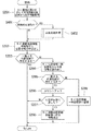
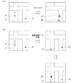
図1は実施例の車両用地図処理システムの車両情報収集装置を示すブロック図である。図2は実施例の車両用地図処理システムの地図情報処理装置を示すブロック図である。図3は実施例の車両用地図処理システムの車両情報収集装置で実行される処理の流れを示すフローチャート図である。図4は実施例の車両用地図処理システムの地図情報処理装置で実行される処理の流れを示すフローチャート図である。図5は実施例の車両用地図処理システムで処理する地図情報の説明図である。図6は実施例の車両用地図処理システムの位置情報の説明図である。図7は実施例のサーバで実行される混雑情報の処理の流れを示すフローチャート図である。
図1,2における主要符号を説明すると、1は車両情報収集装置、11は位置検出部、12は位置情報記憶部、13は位置情報一時記憶部(車両軌跡記憶手段)、14は比較判断部(軌跡算出部、車両判断手段である)、15はマップマッチング部、16は道路地図情報格納部、17は表示処理部、18は通信処理部(通信手段)、2はサーバ(地図情報処理装置)、21はサーバ比較判断部(比較手段であり、混雑検知手段であり、更新手段である)、22はサーバ位置情報一時記憶部(軌跡記憶手段)、23はサーバ道路地図情報格納部、24はサーバ通信処理部(通信手段)、3は位置情報のデータ、31は車両位置のデータ部分、32は進行方向のデータ部分、33は時間情報のデータ部分、34は車速情報のデータ部分、A1は車両、A2は車両位置と進行方向を示すカーソル、B1は既存の道路、B2は既存の道路を示す画像部分、C1は既存の地図情報にない新設道路、C2は地図情報に追加された新設道路を示す画像である。
【0025】
本実施例の車両用地図処理システムは、車両情報収集装置1を車両に搭載し、サーバ2を所定の場所に設置する。
車両情報収集装置1は、ナビゲーション装置に接続あるいは内蔵される。この車両情報収集装置1は、図1に示すように、GPS信号により車両の位置を検出する位置検出部11を設ける。本実施例では、所定時間おきの位置情報を検出することで、走行軌跡を複数の位置情報で構成するようにしている。よって、本実施例中の位置情報は走行軌跡を意味することとなる。
また、位置検出部11で検出した位置情報を記憶しておく位置情報記憶部12と位置情報を一時的に記憶しておく位置情報一時記憶部13を車両情報収集装置1に設ける。
さらに、車両情報収集装置1には、道路地図情報を記憶・保存させておく道路地図情報格納部16を設け、この道路地図情報格納部16の道路地図情報に車両の位置情報を一致させるマップマッチング部15を設け、マップマッチング部15でマッチングした結果を図示しない表示器に表示させる表示処理部17を設ける。
次に、位置情報記憶部12・位置情報一時記憶部13の位置情報及び道路地図情報格納部16の道路地図情報の処理、入出力等を行う比較判断部14を設け、さらに外部との通信を行う通信処理部18を設ける。
【0026】
一方、所定の場所に設置されるサーバ2は、図2に示すように車両情報収集装置1との情報の送受信を行うサーバ通信処理部24を設け、車両情報収集装置1から送られる位置情報を一時的に記憶するサーバ位置情報一時記憶部22を設け、道路地図情報を記憶・保存させておくサーバ道路地図情報格納部23を設け、サーバ位置情報一時記憶部22の位置情報及びサーバ道路地図情報格納部23の道路地図情報の処理、入出力等を行うサーバ比較判断部21を設ける。
【0027】
次に、作用を説明する。
【0028】
[車両情報収集装置での処理]
図3は実施例の車両情報収集装置1で実行される処理の流れを示すフローチャートで、以下、各ステップについて説明する。
【0029】
ステップS101では、位置検出部11により車両の位置をGPS信号より検出し、検出した位置情報を位置情報記憶部12に記憶する。
【0030】
ステップS102では、道路地図情報格納部16から該当する道路の位置情報を読み出す。
【0031】
ステップS103では、ステップS101で検出した車両の位置情報とステップS102で読み出した道路の位置情報が一致するかどうかを比較判断し、一致するならばステップS111に移行し、一致しないならばステップS104に移行する。
【0032】
ステップS104では、位置情報一時記憶部13から位置情報を読み出す。
【0033】
ステップS105では、ステップS101で検出した車両の位置情報とステップS104で読み出した位置情報が一致するかどうかを比較判断し、一致するならばステップS106に移行し、一致しないならばステップS110に移行する。
【0034】
ステップS106では、ステップS101で検出した車両の位置情報とステップS104で読み出した位置情報が一致する回数をカウントする。
【0035】
ステップS107では、ステップS106でカウントされる一致回数が所定の回数に達したかどうかを判断し、所定の回数に達したならばステップS108に移行し、所定の回数に達しないならばステップS111に移行する。
【0036】
ステップS108では、道路地図情報格納部16に記憶・保存している道路地図格納部に新しい道路を登録するように位置情報を追加する。
【0037】
ステップS109では、ステップS108の位置情報をサーバ2に送信する。
【0038】
ステップS110では、位置情報を位置情報一時記憶部13に記憶させる。
【0039】
ステップS111では、位置情報と一致した道路地図情報の該当道路を一致させるマップマッチング処理を行う。
【0040】
ステップS301では、位置情報に含まれる車両位置、進行方向、時間情報、車速情報から突発的な混雑が生じているかどうかを判断し、突発的な混雑と判断するとステップS302に移行し、突発的な混雑でないと判断するとステップS103に移行する。
【0041】
ステップS302では、位置情報に混雑していることを示す情報を加えて混雑情報としてサーバ2に送信する。
【0042】
[サーバでの処理]
図4は実施例のサーバ2で実行される処理の流れを示すフローチャートで、以下、各ステップについて説明する。
【0043】
ステップS201では、サーバ通信処理部24を介して車両情報収集装置1から位置情報を取得する。
【0044】
ステップS202では、サーバ道路地図情報格納部23から位置情報を読み出す。
【0045】
ステップS203では、ステップS201で取得した位置情報とステップS202で読み出した位置情報が一致するかどうかを判断し、一致する場合には処理をリターンし、一致しない場合にはステップS204に移行する。
【0046】
ステップS204では、サーバ位置情報一時記憶部22から位置情報を読み出す。
【0047】
ステップS205では、ステップS201で取得した位置情報とステップS204で取得した位置情報が一致するかどうかを判断し、一致する場合にはステップS06に移行し、一致しない場合にはステップS209に移行する。
【0048】
ステップS206では、ステップS205で判断した位置情報が一致した回数をカウントする。
【0049】
ステップS207では、ステップS206でカウントした回数が所定の回数に達したかどうかを判断し、所定の回数に達していない場合は処理をリターンし、所定の回数に達した場合はステップS208に移行する。
【0050】
ステップS208では、サーバ道路地図情報格納部23に記憶・保存している道路地図格納部に新しい道路を登録するようにステップS201で取得した位置情報を追加する。
【0051】
ステップS209では、ステップS201で取得した位置情報をサーバ位置情報一時記憶部22に一時的に記憶させる。
【0052】
ステップS401では、取得した位置情報が混雑情報かどうかを判断し、混雑情報の場合にはステップS402に移行し、混雑情報ではない場合にはステップS202に移行する。
【0053】
ステップS402では、突発的な混雑に関する処理を行う。詳細は後に示す。
【0054】
[新たな道路の検出・道路地図の変更作用]
本実施例の車両用地図処理システムでは、従来においては、マップマッチングにより、新しい道路とは判断できないような、既存の道路B1に近接して並走する道路C1が完成し、車両A1が通行すると、車両情報収集装置1を搭載した車両A1が多回数通行することとなる。車両情報収集装置1では、走行中は常時、所定の時間間隔で図3に示す処理を行う。すなわち、車両情報収集装置1の位置検出部11により走行軌跡を示す複数ポイントの車両位置を示す位置情報を検出し、位置情報記憶部12に記憶させる。このことはステップS101で行われる。
【0055】
既存の道路B1に近接して並走する道路C1を走行する位置情報は、次に、道路地図情報格納部16の既存の道路の位置情報と比較されるが、一致しないこととなる。このことはステップS103で判断される。
この新しい道路を走行する位置情報が初めて検知された場合は、その位置情報が位置情報一時記憶部13に記憶される。
【0056】
この時点では、ステップS110からステップS111に移行することにより、マップマッチングが行われ、従来と同じように、図5(a)に示すように既存の道路上を走行しているように表示されることとなる。
同じ車両が、この新しい道路を再度、複数回走行すると、位置情報一時記憶部13に一時的に記憶させた位置情報と一致することとなる。このことはステップS105で判断され、ステップS106でカウントされる。このようにして、所定の回数に達すると、その位置情報がサーバ2に送信され、かつ、車両情報収集装置1の道路地図情報格納部16に記憶・保存している道路地図データを示す位置情報に、この位置情報を追加するように更新する。よって、この処理を行ってから、ステップS111でマップマッチングを行うので、図5(b)に示すように、新しい道路が表示される地図に書き込まれ、その新しい道路C2上を走行しているように表示される。
本実施例では、マップマッチングの処理の前に、このような処理を行うことで、既存の道路に並走するような道路であっても確実に検出できる。
【0057】
また、所定の場所に設置されるサーバ2には、新しい道路を所定の回数検知したことを示す位置情報が多数送られてくることとなる。
そのうち初めのものについては、図4のステップS203、S205の判断で、既存の道路の位置情報と一致せず、また、サーバ位置情報一時記憶部22の位置情報とも一致しないので、ステップS209でサーバ位置情報一時記憶部22に一時的に記憶されることとなる。
新しい道路には、車両情報収集装置1を搭載した他の複数の車両が通行することになるので、この位置情報は、複数、送られてくることになり、その位置情報はサーバ位置情報一時記憶部22の位置情報と複数回一致することになる。このことが所定の回数に達するとサーバ道路地図情報格納部23の道路地図データに新しい道路を示す位置情報を追加する。
【0058】
このサーバ道路地図情報格納部23の道路地図情報は、定期的、または随時に車両に配信、あるいは車両からの要求で取得するようにする。
このようにすれば、既存の道路に並走するような新しい道路を検知して、その車両のナビゲーション装置の表示に新しい道路を走行するように表示させながら、他の車両の車両情報収集装置1で検出した新しい道路も含めた道路地図情報を自動的に更新することとなる。
【0059】
[人手やコストの抑制作用]
本実施例では、自動的に新しい道路の情報が追加されていくので、新しい道路の調査や測定、道路地図情報の更新作業を省くことができ、人手とコストを非常に抑制することとなる。さらに、更新を以下のように行うことにより、より道路の調査や測定、道路地図情報の更新作業を省くことができ、人手とコストを非常に抑制することとなる。
なお、これらの判断は、車両情報収集装置1の比較判断部14とサーバ2のサーバ比較判断部21のいずれで行うようにしてもよい。
【0060】
▲1▼一方通行の判断
位置情報3に含まれる走行方向32が、複数の情報で一方向のみとなっている場合には、一方通行の道路として更新する。よって、一方通行かどうかの調査や登録に関する人手とコストを省くこととなる。
【0061】
▲2▼時間規制の判断
位置情報3に含まれる走行時の時間33が、ある時間帯のみ、通行がまったくない状態になっている場合には、時間規制のある道路として更新する。よって、時間規制があるかどうかの調査や登録に関する人手とコストを省くこととなる。
【0062】
▲3▼道路幅員の判断
位置情報3に含まれる車両位置31、走行方向32、その位置での時間33、車速34から、同じ走行方向への並んだ車両位置や、同じ車両の異なる時間での同じ方向への並んだ車両位置、また、道路幅員により規制のかかる車速から道路幅員を判断して更新する。よって、道路幅員に関する調査や登録に関する人手とコストを省くこととなる。
【0063】
[サーバの負荷低減作用]
本実施例の車両用地図処理システムでは、車両情報収集装置1の位置検出部11で検出した位置情報を、その状態でサーバ2に送るのではなく、車両情報収集装置1の道路地図情報格納部16の位置情報と比較し、さらに、位置情報一時記憶部13の位置情報とも比較して、新たな道路であると所定の回数、判断してからサーバ2に送るため、サーバ2ではこれらの処理を行うことなく、複数の車両でどうかの判断から行うことができる。このように、処理の一部を車両側で行うため、サーバ2の負荷は軽いものとなる。
【0064】
[交通のスムーズ化作用]
図7は実施例のサーバ2で実行される混雑情報の処理の流れを示すフローチャートで、以下、各ステップについて説明する。なお、図7に示すステップS411〜S416は、図4のステップS402で処理されるものである。
【0065】
ステップS411では、サーバ位置情報一時記憶部22から混雑情報を呼び出す。
【0066】
ステップS412では、車両情報収集装置1から取得した混雑情報とサーバ位置情報一時記憶部22から呼び出した混雑情報が一致するかどうかを判断し、一致する場合にはステップS413に移行し、一致しない場合にはステップS416に移行する。
【0067】
ステップS413では、ステップS412で一致したと判断された混雑情報の回数をカウントする。
【0068】
ステップS414では、ステップS413でのカウントが所定の回数に達するかどうかを判断し、所定の回数に達した場合にはステップS415に移行し、所定の回数に達しない場合にはステップS202に移行する。
【0069】
ステップS415では、複数の混雑情報を集約して車両に送信する。
【0070】
ステップS416では、混雑情報をサーバ位置情報一時記憶部22に記憶させる。
【0071】
本実施例では、車両位置31、方向32、時間33、車速34、及びこれらから判断される道路幅員を含む位置情報から、車両情報収集装置1の比較判断部14が突発的な混雑を判断すると、図3のステップS301,S302で混雑情報として位置情報をサーバ2に送る。これにより、道路に突発的な混雑が発生すると、そこに位置する複数の車両の車両情報収集装置1から混雑情報が送られるため、その詳細な状況をサーバ2でステップS401により判断できることとなる。この場合には、同じ混雑の状態を示す混雑情報が所定の量のデータ数になることをステップS414で判断し、その場合には混雑情報を集約した情報を付近の車両にステップS415による処理で送信するようにすれば、他の車両が突発的な混雑を回避するのに役立ち、かつ、突発的な混雑に巻き込まれた車両が状況を把握するのに役立つ。よって、道路交通情報通信システムによる交通情報が得られないような場所でも車両からの情報を集約して配信することにより、スムーズな交通に役立てることとなる。
【0072】
次に、効果を説明する。
【0073】
実施例の車両用地図処理システムにあっては、下記に列挙する効果を得ることができる。
【0074】
(1)車両位置情報と道路地図情報から車両の走行軌跡となる位置情報を算出する比較判断部14と、外部との通信を行う通信処理部18からなる車両情報収集装置1を車両に設け、車両情報収集装置1との通信を行うサーバ通信処理部24と、道路地図情報と一致しない車両情報収集装置1からの位置情報を一時的に記憶しておくサーバ位置情報一時記憶部22と、サーバ通信処理部24により得る車両情報収集装置1からの位置情報がサーバ位置情報一時記憶部22の位置情報と略一致するか、道路地図情報と略一致するかを少なくとも比較判断するサーバ比較判断部21と、サーバ比較判断部21の比較判断によりサーバ位置情報一時記憶部22の走行軌跡と複数回略一致すると位置情報を新たな道路としてサーバ道路地図情報格納部23の位置情報を更新する更新手段からなるサーバ2を車外に設け、車両情報収集装置1とサーバ2とから車両用地図処理システムを構成したため、従来のような人手やコストを費やすことなく、既存の道路に隣接した新たな道路も検出でき、道路地図情報を更新できる。
【0075】
(2)車両情報収集装置1が、算出した位置情報と道路地図情報とが一致するかどうかを比較判断部14で比較判断するため、サーバ2の負荷を軽減することができ、サーバ2の設備コストを抑えることができる。
【0076】
(3)車両情報収集装置1が、比較判断部14により位置情報が道路地図情報と一致しないと比較判断した場合に位置情報を一時記憶する位置情報一時記憶部13を有するものであるため、サーバ2の負荷を軽減することができ、サーバ2の設備コストを抑えることができる。
【0077】
(4)車両情報収集装置1の比較判断部14が、算出した位置情報と位置情報一時記憶部13に一時記憶した位置情報とが複数回一致するとサーバ2に走行軌跡を通信処理部18で送信するようにしたため、サーバ2の処理が軽減でき、情報の信頼性が向上する。
【0078】
(5)位置情報には、走行方向を示す情報が含まれるようにし、サーバ2のサーバ比較判断部21が、車両情報収集装置1からの位置情報がサーバ位置情報一時記憶部22の位置情報と複数回略一致し、かつ位置情報の走行方向が複数回一致する際には、一方通行の道路と判断して更新するようにしたため、さらに人手を費やすことなくコストを非常に抑えて道路地図情報の更新を行うことができる。
【0079】
(6)位置情報には、その軌跡で走行した際の時間情報が含まれるものとし、サーバ2のサーバ比較判断部21が、車両情報収集装置1からの位置情報がサーバ位置情報一時記憶部22の位置情報と複数回略一致し、かつ位置情報の走行した際の時間が任意の時間帯に存在しない場合には、時間規制のある道路と判断して更新するようにしたため、さらに人手を費やすことなくコストを非常に抑えて道路地図情報の更新を行うことができる。
【0080】
(7)位置情報には、走行方向、その軌跡で走行した際の時間情報、車速情報が含まれるものとし、サーバ2のサーバ比較判断部21が、位置情報の走行方向、時間情報、車速情報から道路幅員を判断して道路地図情報を更新するようにしたため、さらに人手を費やすことなくコストを非常に抑えて道路地図情報の更新を行うことができる。
【0081】
(8)サーバ2が、車両情報収集装置1からの位置情報の走行方向、時間情報、車速情報及び更新手段で判断される道路幅員から突発的な混雑を検知して車両に混雑情報を通信手段で送信するサーバ比較判断部21を有するものであるため、道路交通情報通信システムで情報を得られないような道路であっても、この混雑情報を得てスムーズな交通を行うことができる。
【0082】
以上、本発明の車両用地図処理システムを実施例に基づき説明してきたが、具体的な構成については、これらの実施例に限られるものではなく、特許請求の範囲の各請求項に係る発明の要旨を逸脱しない限り、設計の変更や追加等は許容される。
例えば、実施例では、比較手段、更新手段、混雑判断手段をサーバ比較判断部が兼ねていたが、別に設けるようにしてもよい。
また、実施例では、車両情報収集装置で処理を行った後にサーバに送って処理を行ったが、処理のほとんどをサーバで行うようにしてもよい。
さらに、一方通行、時間規制、道路幅員を、一度設定した後に、データ数がさらに、多数、集まった際に再判断し、既に登録済みの情報と異なる場合には修正を行う修正手段を設けてさらに情報の精度を向上させるようにしてもよい。
また、実施例では、走行軌跡として複数の位置情報を示したが、走行軌跡を近似曲線式のデータで表現したものや、直線の組み合わせデータで表現したものであってもよい。
【図面の簡単な説明】
【図1】実施例の車両用地図処理システムの車両情報収集装置を示すブロック図である。
【図2】実施例の車両用地図処理システムの地図情報処理装置を示すブロック図である。
【図3】実施例の車両用地図処理システムの車両情報収集装置で実行される処理の流れを示すフローチャート図である。
【図4】実施例の車両用地図処理システムの地図情報処理装置で実行される処理の流れを示すフローチャート図である。
【図5】実施例の車両用地図処理システムで処理する地図情報の説明図である。
【図6】実施例の車両用地図処理システムの位置情報の説明図である。
【図7】実施例のサーバで実行される混雑情報の処理の流れを示すフローチャート図である。
【符号の説明】
1 車両情報収集装置
11 位置検出部
12 位置情報記憶部
13 位置情報一時記憶部
14 比較判断部
15 マップマッチング部
16 道路地図情報格納部
17 表示処理部
18 通信処理部
2 サーバ
21 サーバ比較判断部
22 サーバ位置情報一時記憶部
23 サーバ道路地図情報格納部
24 サーバ通信処理部
3 位置情報のデータ
31 車両位置のデータ部分
32 進行方向のデータ部分
33 時間情報のデータ部分
34 車速情報のデータ部分
A1 車両
A2 車両位置と進行方向を示すカーソル
B1 既存の道路
B2 既存の道路を示す画像部分
C1 既存の地図情報にない新設道路
C2 地図情報に追加された新設道路を示す画像[0001]
TECHNICAL FIELD OF THE INVENTION
The present invention belongs to the technical field of a vehicular map processing system that obtains update information of map data used in a vehicle-mounted device from a vehicle-mounted device and updates map data stored in a center.
[0002]
[Prior art]
2. Description of the Related Art Conventionally, when a road is newly constructed or disappears due to road expansion work or the like, road map information is updated by aerial photography or actual surveying at the site.
According to this method, a great deal of cost and man-hours are required, so that the information update itself is performed once a year. In such a case, a route guidance other than the actual shortest route is performed, for example, when a route is searched, and the original function cannot be sufficiently exhibited.
On the other hand, the conventional road map information updating system performs map matching between the traveling locus of the vehicle and the map data, sets a road outside a predetermined range of the map data as a road leaving state, and updates the map data with the traveling locus. (For example, see Patent Document 1).
[0003]
[Patent Document 1]
JP-A-2002-54934 (page 5-7, FIG. 1)
[0004]
[Problems to be solved by the invention]
However, in the conventional vehicular map processing system, roads adjacent to the existing road are updated by map matching in order to update the road information when it is determined that the vehicle has departed from the existing road by map matching. Could not be detected because it was determined that the vehicle had not left the road.
For this reason, a branch road from an existing road to a newly-built building or road, a newly created detour, a new road running alongside an existing road, and the like are not detected, and the update of map data by a conventional method is awaited. There was a problem that had to be.
[0005]
The present invention has been made in view of the above problems, and an object of the present invention is to provide a vehicular map processing system that can detect a road adjacent to an existing road as a new road. It is in.
[0006]
[Means for Solving the Problems]
In order to achieve the above object, according to the first aspect of the present invention, a vehicle includes a trajectory calculation unit that calculates a trajectory of the vehicle from vehicle position information and road map information, and a vehicle information collection device that includes a communication unit with the outside. Communication means with the vehicle information collecting device, locus storage means for temporarily storing the running locus from the vehicle information collecting device which does not match the road map information, and running locus from the vehicle information collecting device obtained by the communicating means And a comparison determination unit that at least compares and determines whether the traveling locus of the locus storage unit substantially matches the travel locus of the locus storage unit or the road map information. A map information processing device comprising updating means for updating road map information with the traveling locus as a new road is provided outside the vehicle,
The means is constituted by a vehicle information collection device and a map information processing device.
[0007]
According to a second aspect of the present invention, the vehicle information collecting apparatus includes a vehicle determining unit that determines whether or not the traveling locus calculated by the locus calculating unit matches the road map information. And
[0008]
According to a third aspect of the present invention, the vehicle information collection device includes a vehicle trajectory storage unit that temporarily stores the traveling locus when the vehicle determining unit determines that the traveling locus does not match the road map information. It is a characteristic means.
[0009]
According to the fourth aspect of the present invention, the vehicle determining means of the vehicle information collecting device, when the running locus calculated by the locus calculating means and the running locus temporarily stored in the vehicle locus storing means coincide with each other a plurality of times, sends the running locus to the map information processing device. Is transmitted by the communication means.
[0010]
In the invention described in claim 5, the traveling locus includes information indicating the traveling direction, and the comparison determining means of the map information processing device determines that the traveling locus from the vehicle information collecting device is the same as the traveling locus of the locus storage means. The updating means determines that the road is a one-way road and updates the road when the vehicle substantially coincides a plurality of times and the traveling direction of the traveling locus coincides a plurality of times.
[0011]
In the invention according to claim 6, the traveling locus includes time information when the vehicle travels along the locus, and the comparison and determination unit of the map information processing apparatus determines that the traveling locus from the vehicle information collecting apparatus is a locus storage unit. When the traveling locus substantially coincides with the traveling locus a plurality of times and the time when the traveling locus travels does not exist in an arbitrary time zone, the updating unit determines that the road is time-regulated and updates the road. It is a characteristic means.
[0012]
According to the invention described in claim 7, the traveling locus includes a traveling direction, time information when the vehicle travels along the locus, and vehicle speed information. The road map information is updated by judging the road width from the information and the vehicle speed information.
[0013]
According to the invention described in claim 8, the map information processing apparatus detects sudden congestion from the traveling direction of the traveling trajectory from the vehicle information collecting apparatus, time information, vehicle speed information, and road width determined by the updating means. And congestion detecting means for transmitting congestion information by communication means.
[0014]
Function and Effect of the Invention
According to the first aspect of the present invention, the traveling locus that does not match the road in the road map information is temporarily stored in the locus storage unit without being applied to the road in the road map information by map matching. Therefore, even if the traveling locus is adjacent to the road of the road map information, it is not regarded as the road of the road map information. After that, the traveling trajectory sent from the vehicle information collecting device by the communication means is compared with the traveling trajectory stored in the trajectory storing means or the road map information by the comparing and judging means. Therefore, the road adjacent to the road of the road map information that is determined to match the road map information in the conventional map matching will coincide with the traveling locus of the locus storage means, and this is repeated a plurality of times, and When the property increases, the road map information is updated as a new road by the updating means. Therefore, a new road adjacent to an existing road can be detected and road map information can be updated without spending manpower and costs as in the related art.
The "substantially coincident" determined by the comparison determination unit is a substantial coincidence determined in consideration of the number of lanes, and a comparison is made so that the traveling locus or the own vehicle position, which has been conventionally performed, matches the road map information. It is not something that moves the target significantly.
[0015]
According to the second aspect of the present invention, the vehicle information collecting device is provided with a vehicle determining unit. Since the vehicle determination means compares and determines whether the traveling locus and the road map information match, the traveling locus when the traveling locus clearly matches the road map information can be prevented from being transmitted to the map information processing apparatus. The load on the information processing device can be reduced. This also reduces the equipment cost of the map information processing device.
[0016]
According to the third aspect of the invention, the vehicle information collecting device temporarily stores the traveling locus in the vehicle locus storage unit when the vehicle determining unit determines that the traveling locus does not match the road map information. Therefore, a part of the processing of the traveling locus that does not match the road map information can be performed by the vehicle information collection device, and the burden on the map information device can be reduced. This also reduces the equipment cost of the map information processing device.
[0017]
According to the fourth aspect of the present invention, when the travel locus calculated by the locus calculation means and the travel locus temporarily stored in the vehicle locus storage means match a plurality of times, the travel locus is transmitted to the map information processing apparatus by the communication means, so that the map information is transmitted. There is no need to sequentially transmit information to the device for processing, and the processing of the map information device is reduced. In addition, since the traveling locus that the traveling locus temporarily stored on the vehicle side matches a plurality of times is transmitted, the reliability of the information is improved.
[0018]
According to the invention described in claim 5, when the traveling directions of the traveling locus coincide with each other a plurality of times, it can be determined that the road is a one-way road that can only pass in the traveling direction. Judge and update. Therefore, it is possible to update the road map information at a very low cost without spending any manpower on whether the road is one-way.
[0019]
According to the invention described in claim 6, when the time when the vehicle travels along the traveling locus does not exist in an arbitrary time zone, it can be determined that the road is a time-regulated road that cannot pass in that time zone. The updating means determines that the road has time restrictions and updates the road. Therefore, it is possible to update the road map information at a very low cost without spending any manpower on whether or not the road is a time-regulated road.
[0020]
In the invention described in claim 7, the width intervals of the positions of the traveling trajectories for each traveling direction, the width intervals of the traveling trajectories of the same vehicle at different times in the same traveling direction, the vehicle speed regulated by the road width, and the vehicle running at the same time The width of the road is determined from the locus position of the vehicle to be updated, and the updating unit updates the road width. Accordingly, the road map information can be updated at a very low cost without spending labor on the road width.
[0021]
According to the invention described in claim 8, a plurality of traveling trajectories satisfying the road width in a certain traveling direction are determined from the traveling direction, the time information, the vehicle speed information, and the road width determined by the updating unit from the traveling information from the vehicle information collecting device. If the vehicle is present and the vehicle speed is very low, it is determined that the vehicle is suddenly congested and transmitted to the vehicle as congestion information. Therefore, even on a road where information cannot be obtained by the road traffic information communication system, smooth traffic can be performed by obtaining this congestion information.
[0022]
BEST MODE FOR CARRYING OUT THE INVENTION
Hereinafter, embodiments for realizing the vehicle map processing system of the present invention will be described based on embodiments corresponding to the first to eighth aspects of the present invention.
[0023]
(Example)
[0024]
First, the configuration will be described.
FIG. 1 is a block diagram illustrating a vehicle information collecting device of the vehicle map processing system according to the embodiment. FIG. 2 is a block diagram illustrating a map information processing device of the vehicle map processing system according to the embodiment. FIG. 3 is a flowchart illustrating a flow of a process executed by the vehicle information collection device of the vehicle map processing system according to the embodiment. FIG. 4 is a flowchart illustrating a flow of a process performed by the map information processing apparatus of the vehicle map processing system according to the embodiment. FIG. 5 is an explanatory diagram of map information processed by the vehicle map processing system of the embodiment. FIG. 6 is an explanatory diagram of the position information of the vehicle map processing system of the embodiment. FIG. 7 is a flowchart illustrating a flow of processing of congestion information executed by the server according to the embodiment.
1 and 2, reference numeral 1 denotes a vehicle information collecting device, 11 denotes a position detecting unit, 12 denotes a position information storing unit, 13 denotes a position information temporary storing unit (vehicle trajectory storing unit), and 14 denotes a comparison determining unit. (A locus calculation unit and a vehicle determination unit), 15 is a map matching unit, 16 is a road map information storage unit, 17 is a display processing unit, 18 is a communication processing unit (communication unit), and 2 is a server (map information processing device). ), 21 a server comparison / judgment section (comparison means, congestion detection means, and update means), 22 a server location information temporary storage section (trajectory storage means), 23 a server road map information storage section, 24 Is a server communication processing unit (communication means), 3 is position information data, 31 is a vehicle position data part, 32 is a traveling direction data part, 33 is time information data part, 34 is vehicle speed information data part, A1. Is a car , A2 is a cursor indicating a vehicle position and a traveling direction, B1 is an existing road, B2 is an image portion showing an existing road, C1 is a new road not existing in the map information, and C2 is a new road added to the map information. It is an image shown.
[0025]
In the vehicle map processing system of the present embodiment, the vehicle information collection device 1 is mounted on a vehicle, and the server 2 is installed at a predetermined location.
The vehicle information collection device 1 is connected to or built in a navigation device. As shown in FIG. 1, the vehicle information collecting apparatus 1 includes a position detecting unit 11 that detects a position of a vehicle based on a GPS signal. In the present embodiment, the traveling trajectory is configured by a plurality of pieces of position information by detecting the position information every predetermined time. Therefore, the position information in the present embodiment means a traveling locus.
Further, the vehicle information collecting device 1 is provided with a position
Further, the vehicle information collecting device 1 is provided with a road map
Next, a comparison /
[0026]
On the other hand, the server 2 installed at a predetermined place is provided with a server communication processing unit 24 for transmitting and receiving information to and from the vehicle information collecting device 1 as shown in FIG. A server location information
[0027]
Next, the operation will be described.
[0028]
[Processing in vehicle information collection device]
FIG. 3 is a flowchart illustrating a flow of a process performed by the vehicle information collection device 1 according to the embodiment. Each step will be described below.
[0029]
In step S101, the position of the vehicle is detected from the GPS signal by the position detection unit 11, and the detected position information is stored in the position
[0030]
In step S102, the position information of the corresponding road is read from the road map
[0031]
In step S103, it is determined whether or not the position information of the vehicle detected in step S101 matches the position information of the road read in step S102. If they match, the process proceeds to step S111, and if not, the process proceeds to step S104. Transition.
[0032]
In step S104, the position information is read from the position information
[0033]
In step S105, it is determined whether or not the position information of the vehicle detected in step S101 matches the position information read in step S104. If they match, the process proceeds to step S106, and if not, the process proceeds to step S110. .
[0034]
In step S106, the number of times that the position information of the vehicle detected in step S101 matches the position information read in step S104 is counted.
[0035]
In step S107, it is determined whether or not the number of matches counted in step S106 has reached a predetermined number. If the number has reached the predetermined number, the process proceeds to step S108, and if not, the process proceeds to step S111. Transition.
[0036]
In step S108, position information is added so that a new road is registered in the road map storage section stored and stored in the road map
[0037]
In step S109, the position information of step S108 is transmitted to server 2.
[0038]
In step S110, the position information is stored in the position information
[0039]
In step S111, a map matching process for matching the corresponding road of the road map information matching the position information is performed.
[0040]
In step S301, it is determined whether or not sudden congestion has occurred from the vehicle position, traveling direction, time information, and vehicle speed information included in the position information. If it is determined that there is no congestion, the process proceeds to step S103.
[0041]
In step S302, information indicating congestion is added to the position information, and transmitted to the server 2 as congestion information.
[0042]
[Process on server]
FIG. 4 is a flowchart illustrating a flow of processing executed by the server 2 according to the embodiment. Each step will be described below.
[0043]
In step S201, position information is acquired from the vehicle information collection device 1 via the server communication processing unit 24.
[0044]
In step S202, position information is read from the server road map
[0045]
In step S203, it is determined whether or not the position information acquired in step S201 matches the position information read in step S202. If they match, the process returns, and if not, the process proceeds to step S204.
[0046]
In step S204, the location information is read from the server location information
[0047]
In step S205, it is determined whether or not the position information obtained in step S201 matches the position information obtained in step S204. If they match, the process proceeds to step S06.
[0048]
In step S206, the number of times the position information determined in step S205 matches is counted.
[0049]
In step S207, it is determined whether the number counted in step S206 has reached a predetermined number. If the number has not reached the predetermined number, the process returns. If the number has reached the predetermined number, the process proceeds to step S208. .
[0050]
In step S208, the position information acquired in step S201 is added so that a new road is registered in the road map storage unit stored and stored in the server road map
[0051]
In step S209, the location information acquired in step S201 is temporarily stored in the server location information
[0052]
In step S401, it is determined whether or not the acquired position information is congestion information. If it is congestion information, the process proceeds to step S402, and if not, the process proceeds to step S202.
[0053]
In step S402, processing related to sudden congestion is performed. Details will be described later.
[0054]
[Detection of new roads / change of road map]
In the vehicle map processing system according to the present embodiment, conventionally, when a road C1 running parallel to an existing road B1 is completed and the vehicle A1 passes, the map matching does not determine that the road is a new road. Therefore, the vehicle A1 equipped with the vehicle information collection device 1 will pass many times. The vehicle information collection device 1 always performs the processing shown in FIG. 3 at predetermined time intervals during traveling. That is, the position information indicating the vehicle positions at a plurality of points indicating the traveling locus is detected by the position detection unit 11 of the vehicle information collection device 1 and stored in the position
[0055]
Next, the position information traveling on the road C1 running parallel to the existing road B1 is compared with the position information of the existing road in the road map
When the position information traveling on this new road is detected for the first time, the position information is stored in the position information
[0056]
At this time, the process proceeds from step S110 to step S111, so that the map matching is performed, and as in the conventional case, it is displayed as if the vehicle is running on an existing road as shown in FIG. It will be.
When the same vehicle travels on the new road a plurality of times again, the position information coincides with the position information temporarily stored in the position information
In the present embodiment, by performing such processing before the map matching processing, it is possible to reliably detect a road that runs parallel to an existing road.
[0057]
Also, a large number of position information indicating that a new road has been detected a predetermined number of times is sent to the server 2 installed at a predetermined place.
The first one of them does not match the existing road position information and does not match the position information in the server position information
Since a plurality of other vehicles equipped with the vehicle information collecting device 1 pass on the new road, a plurality of pieces of this position information are sent, and the position information is temporarily stored in the server position information. It will match the position information of the unit 22 a plurality of times. When this reaches a predetermined number of times, position information indicating a new road is added to the road map data in the server road map
[0058]
The road map information in the server road map
With this configuration, a new road that runs alongside an existing road is detected, and the vehicle information collection device 1 of another vehicle is detected while displaying the new road on the display of the navigation device of the vehicle. Will automatically update the road map information including the new road detected in step (1).
[0059]
[Control of manpower and costs]
In the present embodiment, information of a new road is automatically added, so that investigation and measurement of a new road and update work of road map information can be omitted, so that manpower and costs are greatly reduced. Further, by performing the update as described below, the work of investigating and measuring the road and updating the road map information can be further omitted, and the manpower and cost can be greatly reduced.
These determinations may be made by either the comparison /
[0060]
(1) One-way decision
When the traveling
[0061]
(2) Judgment of time regulation
When the traveling
[0062]
③ Decision of road width
From the
[0063]
[Server load reduction effect]
In the vehicle map processing system according to the present embodiment, the position information detected by the position detection unit 11 of the vehicle information collection device 1 is not sent to the server 2 in that state, but the road map information storage unit of the vehicle information collection device 1 is used. 16 is compared with the position information in the position information
[0064]
[Transport smoothing effect]
FIG. 7 is a flowchart showing the flow of the congestion information processing executed by the server 2 of the embodiment. Each step will be described below. Steps S411 to S416 shown in FIG. 7 are processed in step S402 in FIG.
[0065]
In step S411, the congestion information is called from the server location information
[0066]
In step S412, it is determined whether or not the congestion information acquired from the vehicle information collection device 1 and the congestion information called from the server location information
[0067]
In step S413, the number of times of congestion information determined to match in step S412 is counted.
[0068]
In step S414, it is determined whether or not the count in step S413 reaches a predetermined number. If the count has reached the predetermined number, the process proceeds to step S415, and if not, the process proceeds to step S202. .
[0069]
In step S415, a plurality of congestion information is aggregated and transmitted to the vehicle.
[0070]
In step S416, the congestion information is stored in the server location information
[0071]
In the present embodiment, when the
[0072]
Next, effects will be described.
[0073]
In the vehicle map processing system of the embodiment, the following effects can be obtained.
[0074]
(1) The vehicle is provided with a vehicle information collection device 1 including a comparison and
[0075]
(2) Since the vehicle information collecting apparatus 1 compares and judges whether or not the calculated position information and the road map information match, the load on the server 2 can be reduced, and the equipment of the server 2 can be reduced. Costs can be reduced.
[0076]
(3) Since the vehicle information collecting apparatus 1 has the position information
[0077]
(4) When the calculated position information matches the position information temporarily stored in the position information temporary storage unit 13 a plurality of times, the
[0078]
(5) The position information includes information indicating the traveling direction, and the server comparison /
[0079]
(6) The position information includes time information when the vehicle travels along the locus, and the server comparison /
[0080]
(7) It is assumed that the position information includes the traveling direction, time information when traveling along the locus, and vehicle speed information, and the server comparison /
[0081]
(8) The server 2 detects sudden running congestion from the traveling direction, time information, vehicle speed information, and road width determined by the updating means of the position information from the vehicle information collecting device 1 and transmits congestion information to the vehicle. Therefore, even on a road on which information cannot be obtained by the road traffic information communication system, traffic can be smoothly obtained by obtaining this congestion information.
[0082]
As described above, the vehicle map processing system of the present invention has been described based on the embodiments. However, the specific configuration is not limited to these embodiments, and the present invention is not limited to the embodiments. Changes and additions to the design are permitted as long as they do not deviate from the gist.
For example, in the embodiment, the comparison unit, the update unit, and the congestion determination unit also serve as the server comparison determination unit, but may be provided separately.
Further, in the embodiment, after the processing is performed by the vehicle information collecting apparatus, the processing is sent to the server and the processing is performed. However, most of the processing may be performed by the server.
Further, after one-way, time regulation, and road width are set once, a revising means is provided for re-determining when the number of data further increases, and when the information differs from the already registered information, a correction means is provided. Further, the accuracy of the information may be improved.
Further, in the embodiment, a plurality of pieces of position information are shown as the traveling locus. However, the traveling locus may be represented by data of an approximate curve expression, or may be represented by combination data of straight lines.
[Brief description of the drawings]
FIG. 1 is a block diagram illustrating a vehicle information collection device of a vehicle map processing system according to an embodiment.
FIG. 2 is a block diagram illustrating a map information processing apparatus of the vehicle map processing system according to the embodiment;
FIG. 3 is a flowchart illustrating a flow of a process executed by a vehicle information collecting device of the vehicle map processing system according to the embodiment;
FIG. 4 is a flowchart illustrating a flow of processing executed by the map information processing apparatus of the vehicle map processing system according to the embodiment;
FIG. 5 is an explanatory diagram of map information processed by the vehicle map processing system of the embodiment.
FIG. 6 is an explanatory diagram of position information of the vehicle map processing system of the embodiment.
FIG. 7 is a flowchart illustrating a flow of processing of congestion information executed by the server according to the embodiment;
[Explanation of symbols]
1 Vehicle information collection device
11 Position detector
12 Location information storage
13 Temporary location information storage
14 Comparison judgment section
15 Map matching part
16 Road map information storage
17 Display processing unit
18 Communication processing unit
2 server
21 Server comparison judgment unit
22 Server location information temporary storage
23 server road map information storage
24 server communication processing unit
3 location information data
31 Vehicle position data part
32 Data part of heading direction
33 Data part of time information
34 Data part of vehicle speed information
A1 vehicle
A2 Cursor indicating vehicle position and traveling direction
B1 Existing road
B2 Image part showing existing road
C1 New road not in existing map information
Image showing new road added to C2 map information
Claims (8)
前記車両情報収集装置との通信手段と、道路地図情報と一致しない前記車両情報収集装置からの走行軌跡を一時的に記憶しておく軌跡記憶手段と、前記通信手段により得る前記車両情報収集装置からの走行軌跡が前記軌跡記憶手段の走行軌跡と略一致するか、道路地図情報と略一致するかを少なくとも比較判断する比較判断手段と、前記比較判断手段の比較判断により前記軌跡記憶手段の走行軌跡と複数回略一致すると走行軌跡を新たな道路として道路地図情報を更新する更新手段からなる地図情報処理装置を車外に設け、
前記車両情報収集装置と前記地図情報処理装置とから構成されることを特徴とする車両用地図処理システム。A vehicle information collection device including a vehicle path information calculating unit that calculates a vehicle traveling path from the vehicle position information and the road map information, and a communication unit with the outside;
Communication means with the vehicle information collection device, trajectory storage means for temporarily storing a running trajectory from the vehicle information collection device that does not match the road map information, and the vehicle information collection device obtained by the communication means Comparing and judging at least whether the traveling locus of the vehicle substantially coincides with the traveling locus of the locus storing means or substantially coincides with the road map information; and the traveling locus of the locus storing means based on the comparative judgment of the comparing and judging means. And a map information processing device comprising updating means for updating the road map information with the traveling locus as a new road when the vehicle substantially coincides with a plurality of times is provided outside the vehicle,
A vehicle map processing system comprising the vehicle information collection device and the map information processing device.
車両情報収集装置が、軌跡算出手段で算出した走行軌跡と道路地図情報とが一致するかどうかを比較判断する車両判断手段を有するものであることを特徴とする車両用地図処理システム。The vehicle map processing system according to claim 1,
A vehicle map processing system comprising: a vehicle information collection device including vehicle determination means for comparing and determining whether a traveling locus calculated by a locus calculation means matches road map information.
車両情報収集装置が、車両判断手段により走行軌跡が道路地図情報と一致しないと比較判断した場合に前記走行軌跡を一時記憶する車両軌跡記憶手段を有するものであることを特徴とする車両用地図処理システム。The vehicle map processing system according to claim 2,
A vehicle information collection device having a vehicle trajectory storage means for temporarily storing the travel trajectory when the vehicle determination means determines that the travel locus does not match the road map information; system.
車両情報収集装置の車両判断手段が、軌跡算出手段で算出した走行軌跡と車両軌跡記憶手段に一時記憶した走行軌跡とが複数回一致すると地図情報処理装置に走行軌跡を通信手段で送信するようにしたことを特徴とする車両用地図処理システム。The vehicle map processing system according to claim 3,
The vehicle determining means of the vehicle information collecting apparatus transmits the running locus to the map information processing apparatus by the communication means when the running locus calculated by the locus calculating means and the running locus temporarily stored in the vehicle locus storing means match a plurality of times. A map processing system for a vehicle, comprising:
走行軌跡には、走行方向を示す情報が含まれるようにし、
地図情報処理装置の比較判断手段が、車両情報収集装置からの走行軌跡が軌跡記憶手段の走行軌跡と複数回略一致し、かつ走行軌跡の走行方向が複数回一致する際には、更新手段が一方通行の道路と判断して更新するようにしたことを特徴とする車両用地図処理システム。In the vehicle map processing system according to claim 1,
The traveling locus includes information indicating the traveling direction,
When the traveling trajectory from the vehicle information collecting device substantially matches the traveling trajectory of the trajectory storage device a plurality of times and the traveling direction of the traveling trajectory matches the traveling direction a plurality of times, the updating unit determines A vehicle map processing system characterized in that it is determined to be a one-way road and updated.
走行軌跡には、その軌跡で走行した際の時間情報が含まれるものとし、
地図情報処理装置の比較判断手段が、車両情報収集装置からの走行軌跡が軌跡記憶手段の走行軌跡と複数回略一致し、かつ走行軌跡の走行した際の時間が任意の時間帯に存在しない場合には、更新手段が時間規制のある道路と判断して更新するようにしたことを特徴とする車両用地図処理システム。In the vehicle map processing system according to claim 1,
The traveling locus includes time information when the vehicle travels on the locus,
When the comparison deciding means of the map information processing device determines that the traveling locus from the vehicle information collecting device substantially coincides with the traveling locus of the locus storage device a plurality of times, and the time when the traveling locus has traveled does not exist in any time zone Wherein the updating means determines that the road is time-restricted and updates the road.
走行軌跡には、走行方向、その軌跡で走行した際の時間情報、車速情報が含まれるものとし、
地図情報処理装置の更新手段が、走行軌跡の走行方向、時間情報、車速情報から道路幅員を判断して道路地図情報を更新するようにしたことを特徴とする車両用地図処理システム。In the vehicle map processing system according to claim 1,
The traveling locus includes a traveling direction, time information when the vehicle travels along the locus, and vehicle speed information.
A map processing system for a vehicle, wherein the updating means of the map information processing device updates the road map information by determining the road width from the traveling direction of the traveling locus, time information, and vehicle speed information.
地図情報処理装置が、車両情報収集装置からの走行軌跡の走行方向、時間情報、車速情報及び更新手段で判断される道路幅員から突発的な混雑を検知して車両に混雑情報を通信手段で送信する混雑検知手段を有するものであることを特徴とする車両用地図処理システム。The vehicle map processing system according to claim 7,
The map information processing device detects sudden congestion from the traveling direction, time information, vehicle speed information and road width determined by the updating means from the vehicle information collecting device, and transmits congestion information to the vehicle through the communication means. A map processing system for a vehicle, comprising:
Priority Applications (1)
| Application Number | Priority Date | Filing Date | Title |
|---|---|---|---|
| JP2003080250A JP2004286641A (en) | 2003-03-24 | 2003-03-24 | Map-processing system for vehicle |
Applications Claiming Priority (1)
| Application Number | Priority Date | Filing Date | Title |
|---|---|---|---|
| JP2003080250A JP2004286641A (en) | 2003-03-24 | 2003-03-24 | Map-processing system for vehicle |
Publications (1)
| Publication Number | Publication Date |
|---|---|
| JP2004286641A true JP2004286641A (en) | 2004-10-14 |
Family
ID=33294159
Family Applications (1)
| Application Number | Title | Priority Date | Filing Date |
|---|---|---|---|
| JP2003080250A Pending JP2004286641A (en) | 2003-03-24 | 2003-03-24 | Map-processing system for vehicle |
Country Status (1)
| Country | Link |
|---|---|
| JP (1) | JP2004286641A (en) |
Cited By (19)
| Publication number | Priority date | Publication date | Assignee | Title |
|---|---|---|---|---|
| JP2005098853A (en) * | 2003-09-25 | 2005-04-14 | Toyota Motor Corp | Map data updating method and map data updating apparatus |
| JP2006220567A (en) * | 2005-02-10 | 2006-08-24 | Yanmar Co Ltd | System for recognizing field position for working machine with gps |
| JP2007192667A (en) * | 2006-01-19 | 2007-08-02 | Matsushita Electric Ind Co Ltd | Route guidance system |
| JP2008164821A (en) * | 2006-12-27 | 2008-07-17 | Aisin Aw Co Ltd | Map information generation system |
| JP2008164824A (en) * | 2006-12-27 | 2008-07-17 | Aisin Aw Co Ltd | Map information distribution system |
| JP2008164826A (en) * | 2006-12-27 | 2008-07-17 | Aisin Aw Co Ltd | Map information generation system |
| JP2008170277A (en) * | 2007-01-11 | 2008-07-24 | Nec Computertechno Ltd | Road map information correcting system, road map information correction method, and road map information correction program |
| JP2009026082A (en) * | 2007-07-19 | 2009-02-05 | Pioneer Electronic Corp | Navigation system and navigation method |
| US7627414B2 (en) | 2005-08-03 | 2009-12-01 | Denso Corporation | Road map management system |
| GB2465893A (en) * | 2008-12-03 | 2010-06-09 | Denso Corp | Means for updating a road map database of a navigation device |
| JP2010139366A (en) * | 2008-12-11 | 2010-06-24 | Aisin Aw Co Ltd | Device, method, and program for detecting new road |
| WO2011122150A1 (en) * | 2010-03-30 | 2011-10-06 | 株式会社トヨタマップマスター | Road information identification device, method for same, computer program for identifying road information, and recording medium on which said computer program is recorded |
| US8073617B2 (en) | 2006-12-27 | 2011-12-06 | Aisin Aw Co., Ltd. | Map information generating systems, methods, and programs |
| JP2016138812A (en) * | 2015-01-28 | 2016-08-04 | 三菱電機株式会社 | Navigation device and navigation method |
| US10145690B2 (en) * | 2014-03-24 | 2018-12-04 | Aisin Aw Co., Ltd. | Map information generation system, method, and program |
| CN109783593A (en) * | 2018-12-27 | 2019-05-21 | 驭势科技(北京)有限公司 | A kind of map updating system can be used for automatic Pilot and method |
| CN111351494A (en) * | 2015-02-10 | 2020-06-30 | 御眼视觉技术有限公司 | Navigation system and computer readable medium |
| US20210389156A1 (en) * | 2020-12-25 | 2021-12-16 | Beijing Baidu Netcom Science And Technology Co., Ltd. | Map rendering method and apparatus, device, and storage medium |
| US20220003571A1 (en) * | 2020-07-01 | 2022-01-06 | Toyota Jidosha Kabushiki Kaisha | Information processing method, non-transitory computer readable medium, in-vehicle apparatus, vehicle, information processing apparatus, and information processing system |
-
2003
- 2003-03-24 JP JP2003080250A patent/JP2004286641A/en active Pending
Cited By (24)
| Publication number | Priority date | Publication date | Assignee | Title |
|---|---|---|---|---|
| JP2005098853A (en) * | 2003-09-25 | 2005-04-14 | Toyota Motor Corp | Map data updating method and map data updating apparatus |
| JP4667060B2 (en) * | 2005-02-10 | 2011-04-06 | ヤンマー株式会社 | Field position recognition system with GPS working machine |
| JP2006220567A (en) * | 2005-02-10 | 2006-08-24 | Yanmar Co Ltd | System for recognizing field position for working machine with gps |
| US7627414B2 (en) | 2005-08-03 | 2009-12-01 | Denso Corporation | Road map management system |
| JP2007192667A (en) * | 2006-01-19 | 2007-08-02 | Matsushita Electric Ind Co Ltd | Route guidance system |
| JP2008164821A (en) * | 2006-12-27 | 2008-07-17 | Aisin Aw Co Ltd | Map information generation system |
| JP2008164824A (en) * | 2006-12-27 | 2008-07-17 | Aisin Aw Co Ltd | Map information distribution system |
| JP2008164826A (en) * | 2006-12-27 | 2008-07-17 | Aisin Aw Co Ltd | Map information generation system |
| US8073617B2 (en) | 2006-12-27 | 2011-12-06 | Aisin Aw Co., Ltd. | Map information generating systems, methods, and programs |
| JP2008170277A (en) * | 2007-01-11 | 2008-07-24 | Nec Computertechno Ltd | Road map information correcting system, road map information correction method, and road map information correction program |
| JP2009026082A (en) * | 2007-07-19 | 2009-02-05 | Pioneer Electronic Corp | Navigation system and navigation method |
| GB2465893A (en) * | 2008-12-03 | 2010-06-09 | Denso Corp | Means for updating a road map database of a navigation device |
| GB2465893B (en) * | 2008-12-03 | 2013-12-11 | Denso Corp | Map data processor and method for processing information based on map data |
| US8352182B2 (en) | 2008-12-03 | 2013-01-08 | Denso Corporation | Map data processor and method for processing information based on map data |
| JP2010139366A (en) * | 2008-12-11 | 2010-06-24 | Aisin Aw Co Ltd | Device, method, and program for detecting new road |
| WO2011122150A1 (en) * | 2010-03-30 | 2011-10-06 | 株式会社トヨタマップマスター | Road information identification device, method for same, computer program for identifying road information, and recording medium on which said computer program is recorded |
| JPWO2011122150A1 (en) * | 2010-03-30 | 2013-07-08 | 株式会社トヨタマップマスター | Road information specifying device and method, computer program for specifying road information, and recording medium recording the computer program |
| JP5647670B2 (en) * | 2010-03-30 | 2015-01-07 | 株式会社トヨタマップマスター | Road lane number information identification device and method, computer program for identifying road lane number information, and recording medium recording the computer program |
| US10145690B2 (en) * | 2014-03-24 | 2018-12-04 | Aisin Aw Co., Ltd. | Map information generation system, method, and program |
| JP2016138812A (en) * | 2015-01-28 | 2016-08-04 | 三菱電機株式会社 | Navigation device and navigation method |
| CN111351494A (en) * | 2015-02-10 | 2020-06-30 | 御眼视觉技术有限公司 | Navigation system and computer readable medium |
| CN109783593A (en) * | 2018-12-27 | 2019-05-21 | 驭势科技(北京)有限公司 | A kind of map updating system can be used for automatic Pilot and method |
| US20220003571A1 (en) * | 2020-07-01 | 2022-01-06 | Toyota Jidosha Kabushiki Kaisha | Information processing method, non-transitory computer readable medium, in-vehicle apparatus, vehicle, information processing apparatus, and information processing system |
| US20210389156A1 (en) * | 2020-12-25 | 2021-12-16 | Beijing Baidu Netcom Science And Technology Co., Ltd. | Map rendering method and apparatus, device, and storage medium |
Similar Documents
| Publication | Publication Date | Title |
|---|---|---|
| JP2004286641A (en) | Map-processing system for vehicle | |
| US6915207B2 (en) | Method and system for setting travel time and method and system for route calculation with use thereof | |
| JP5234691B2 (en) | Navigation device, probe information transmission method, program, and traffic information creation device | |
| US8036820B2 (en) | Vehicle-mounted device, traffic-information acquisition method, traffic-information provision system, and traffic-information provision method | |
| US7590488B2 (en) | Route condition evaluation method and apparatus for navigation system | |
| US9672739B2 (en) | Map data update device | |
| JP4973640B2 (en) | Route search device and information management server | |
| JP3557776B2 (en) | Route guidance device for vehicles | |
| CN102235879B (en) | Route search devices and route guiding system | |
| JP4255028B2 (en) | Traffic information transmission method for navigation device and server device | |
| US20160169693A1 (en) | Probabilistic Reverse Geocoding | |
| JP2010210284A (en) | Traffic management device and traffic management method | |
| JP6813368B2 (en) | Electronics, driver assistance systems and programs | |
| JP2011232146A (en) | Car navigation system | |
| JP2006047246A (en) | Route searching method for navigation system | |
| JP3775394B2 (en) | Travel link determination system and link travel time measurement system | |
| JP5686583B2 (en) | Information distribution system, distribution server, and distribution method | |
| CN102243812A (en) | Navigation device and traffic information prompting method | |
| JP5131226B2 (en) | Map data update device | |
| JP2014122859A (en) | Road information collection device and road information collection program | |
| JP2006146695A (en) | System for providing traffic congestion information | |
| JP2010043938A (en) | Present position calculating device | |
| JP3747821B2 (en) | Route guidance system and vehicle route guidance device | |
| JP3982429B2 (en) | Vehicle navigation device | |
| JP2007127564A (en) | Navigation system |
Legal Events
| Date | Code | Title | Description |
|---|---|---|---|
| RD04 | Notification of resignation of power of attorney |
Free format text: JAPANESE INTERMEDIATE CODE: A7424 Effective date: 20051114 |