JP2004205379A - Map information updating device, map information updating method and program - Google Patents
Map information updating device, map information updating method and program Download PDFInfo
- Publication number
- JP2004205379A JP2004205379A JP2002375580A JP2002375580A JP2004205379A JP 2004205379 A JP2004205379 A JP 2004205379A JP 2002375580 A JP2002375580 A JP 2002375580A JP 2002375580 A JP2002375580 A JP 2002375580A JP 2004205379 A JP2004205379 A JP 2004205379A
- Authority
- JP
- Japan
- Prior art keywords
- information
- road
- map
- storage unit
- map information
- Prior art date
- Legal status (The legal status is an assumption and is not a legal conclusion. Google has not performed a legal analysis and makes no representation as to the accuracy of the status listed.)
- Withdrawn
Links
Images


Landscapes
- Navigation (AREA)
- Traffic Control Systems (AREA)
- Instructional Devices (AREA)
Abstract
Description
【0001】
【発明の属する技術分野】
本発明は、地図情報更新装置、地図情報更新方法及びプログラムに関し、特に、位置情報に基いて地図を更新する地図情報更新装置、地図情報更新方法及びプログラムに関する。
【0002】
【従来の技術】
従来より、カーナビゲーション装置を利用しているときの問題の一つに、その装置にストアされている地図情報が更新されていないために、カーナビゲーション装置が表示する地図と移動している車の場所の不整合がある。例えば、車が新設された道路を通ると、地図情報にその新設された道路情報が含まれていないために、カーナビゲーション装置が表示する地図上では道路がないところを、車が移動しているように、表示されてしまう。
【0003】
そこで、このような問題を解決するために、道路の新設があったとき、その新設道路の情報を含む更新された地図情報を外部から通信によってカーナビゲーション装置に取り込み、ストアされている地図情報を更新する装置が提案されている(例えば、特許文献1参照)。この方法によれば、カーナビゲーション装置には更新された道路情報がストアされるので、ユーザは、その新設された道路も表示される最新の地図情報を用いて、カーナビゲーション装置を利用することができる。
【0004】
また、他の解決方法として、車の搭載されたカーナビゲーション装置は、実際に車が通った道路の走行軌跡データを生成し、情報センタに送信し、情報センタでは、受信した走行軌跡データに基づいて地図情報を更新し、更新した地図情報を車のカーナビゲーション装置へ配信するシステムが提案されている(例えば、特許文献2参照)。このシステムによれば、道路情報の航空写真撮影、現地調査などを行うことなく、カーナビゲーション装置の道路地図情報の更新を迅速かつ低コストで実現できるものである。
【0005】
【特許文献1】
特開平8-95488号公報(第4頁、第1図)
【0006】
【特許文献2】
特開2002-54934号公報(第6頁から第7頁、第1図)
【0007】
【発明が解決しようとする課題】
しかし、前者の更新された地図情報を外部から通信によってカーナビゲーション装置が取得する方法では、地図情報が更新されるまでの間は、ユーザは、最新の地図情報を利用できないという問題がある。すなわち、地図情報が更新されるまでは、地図情報にない道路は表示されないので、ユーザは、カーナビゲーション装置を、新設された道路を通るために利用することはできない。
【0008】
また、後者の方法では、情報センタにおいてユーザからの走行軌跡情報を利用して道路情報を作成し、その道路情報をそのまま情報センタから配信してしまうと、例えば、ユーザが極めて悪い道路をどうにか通過できたような道路まで、他のユーザには道路が存在することになり、実際に行ってみたら、トラックのような車しか通れない道路で、通常の乗用車では通れないという場合も生じてしまう。
【0009】
そこで、本発明は、更新された地図情報を外部から取得することなく、ユーザが通行するだけで、地図情報が更新される地図情報更新装置を提供することを目的とする。
【0010】
【課題を解決するための手段】
本発明の地図情報更新装置は、地図情報を記憶する地図情報記憶部と、前記地図情報に含まれる道路情報と現在位置の情報とに基き、該現在位置が、前記地図情報に含まれる道路情報についての道路上にあるか否かを判断する判断手段と、該判断手段によって、前記現在位置が前記道路上にないと判断されたときに、前記現在位置の位置情報を位置情報記憶部に記憶する位置情報記憶手段と、前記位置情報記憶部に記憶された前記位置情報に基いて、道路情報を生成する道路情報生成手段と、該道路情報生成手段によって生成された前記道路情報を、前記地図情報記憶部に記憶する道路情報記憶手段とを有する。
【0011】
本発明の地図情報更新方法は、地図情報記憶部に記憶された地図情報に含まれる道路情報と現在位置の情報とに基き、該現在位置が、前記地図情報に含まれる道路情報についての道路上にあるか否かを判断し、該判断の結果、前記現在位置が前記道路上にないときに、前記現在位置の位置情報を位置情報記憶部に記憶し、前記位置情報記憶部に記憶された前記位置情報に基いて道路情報を生成し、生成された前記道路情報を前記地図情報記憶部に記憶する。
【0012】
本発明のプログラムは、コンピュータに、地図情報記憶部に記憶された地図情報に含まれる道路情報と現在位置の情報とに基き、該現在位置が、前記地図情報に含まれる道路情報についての道路上にあるか否かを判断する機能と、該判断の結果、前記現在位置が前記道路上にないときに、前記現在位置の位置情報を位置情報記憶部に記憶する機能と、前記位置情報記憶部に記憶された前記位置情報に基いて道路情報を生成する機能と、生成された前記道路情報を前記地図情報記憶部に記憶する機能を実現させるためのプログラムである。
このような構成によれば、更新された地図情報を外部から取得することなく、ユーザが通行するだけで、地図情報が更新される地図情報更新装置を実現することができる。
【0013】
また、本発明の地図情報更新装置において、さらに、前記地図情報記憶部に記憶された前記道路情報に関連する情報として前記地図情報記憶部に記憶するために、道路種別又は道路規制の情報を入力させるための関連情報入力手段を有することが望ましい。
このような構成によれば、カーナビゲーション装置の利用に際し、道路の関連情報を表示させて利用することができる。
【0014】
また、本発明の地図情報更新装置において、さらに、無線による通信手段と、該通信手段を介して、前記道路情報生成手段によって生成され、前記地図情報記憶部に記憶された前記道路情報を送信する道路情報送信手段とを有することが望ましい。
このような構成によれば、他のユーザに新規に登録した道路情報を送信して、他のユーザも利用することができる。
【0015】
また、本発明の地図情報更新装置において、さらに、無線による通信手段を有し、前記道路情報記憶手段は、前記通信手段を介して、前記道路情報を受信した道路情報を、前記地図情報記憶部に記憶することが望ましい。
このような構成によれば、ユーザは、他のユーザが生成して登録した道路情報を受信して登録することによって、他のユーザが生成した道路情報も利用することができる。
【0016】
また、本発明の地図情報更新装置において、さらに、前記道路情報生成手段によって生成され、前記地図情報記憶部に記憶された前記道路情報を、可搬記録媒体に記録する可搬記録媒体記録手段を有することが望ましい。
このような構成によれば、他のユーザに新規に登録した道路情報が記録された可搬記録媒体を渡して、他のユーザも利用することができる。
【0017】
また、本発明の地図情報更新装置において、前記判断手段は、前記現在位置まで前記位置情報の軌跡の辿ってきた方向ベクトルと、前記現在位置からその後予め決められた時間内に得られた前記位置情報の軌跡の辿った方向ベクトルとのなす角度が、予め設定された角度以上変化したときに、前記現在位置が前記道路上にないと判断するが望ましい。
このような構成によれば、確実に現在位置が道路上にないと判断することができる。
【0018】
また、本発明の地図情報更新装置において、さらに、スイッチを有し、該スイッチがオンとなっている場合には、前記判断手段と、前記位置情報記憶手段と、前記道路情報生成手段と、前記道路情報記憶手段とを実行し、前記スイッチがオフとなっている場合には、前記判断手段と、前記位置情報記憶手段と、前記道路情報生成手段と、前記道路情報記憶手段が実行されないことが望ましい。
このような構成によれば、ユーザはスイッチを押した後、自動的に既存の道路上にないところだけの位置情報が記憶され、道路情報を生成して登録することができる。
【0019】
また、本発明の地図情報更新装置において、さらに、前記地図情報記憶部から地図情報を抽出して表示装置上に画像として表示させる地図表示制御手段を有し、 前記地図表示制御手段は、前記道路情報生成手段によって生成され前記地図情報記憶部に記憶された前記道路情報を、他の前記道路情報の色とは異なる色で、前記表示装置上に表示させることが望ましい。
このような構成によれば、追加登録された道路情報に係る道路を、ユーザは他の道路と区別して明確に認識することができる。
【0020】
【発明の実施の形態】
以下、図面を参照して本発明の実施の形態に係る地図情報更新装置を説明する。
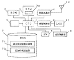
まず、図1に基づき、本実施の形態に係わる地図情報更新装置の例としての、カーナビゲーション装置の構成を説明する。図1は、本実施の形態に係わるカーナビゲーション装置の構成例を示すブロック構成図である。図1に示す構成を有するカーナビゲーション装置が車に搭載される。
【0021】
1は、中央処理装置(CPU)であり、CPU1には、ROM2と、RAM3と、位置認識部4と、可搬記録媒体記録制御部5と、映像制御部6と、地図情報記憶部としてのハードディスクドライブ(以下、HDDと略す)7と、書き込みモード切替スイッチ(以下、SWと略す)8と、無線による通信手段を制御するための通信制御部9が接続されている。
【0022】
CPU1は、ROM2にストアされた各種ソフトウエアプログラムをRAM3に読み出して実行する。
ROM2には、地図表示制御手段としての地図表示制御ソフトウエアプログラム(以下、ソフトウエアプログラムを、単にソフトウエアという)、他のカーナビゲーション装置等との通信制御手段としての通信制御ソフトウエア、追加される道路情報を記憶するためのソフトウエア、道路情報生成ソフトウエア等が記憶されている。
【0023】
位置認識部4は、位置認識部4に接続されたGPS(Global Positioning System)用のアンテナ9が人工衛星から受信した電波に基いて、カーナビゲーション装置が搭載された車の現在位置を認識するためのものである。位置認識部4は、受信した電波信号に基づいて演算して得られた現在位置情報を、緯度及び経度データとして、CPU1へ供給する。
【0024】
可搬記録媒体制御部5は、着脱可能な物理的な可搬記録媒体(図示せず)が接続可能であり、CPU1の制御の下、外部メモリとしての可搬記録媒体へ道路情報を記録する記録手段である。可搬記録媒体は、メモリカード等の記録媒体である。
映像制御部6は、映像制御部6に接続された液晶表示装置(LCD)11を制御するためのものであり、CPU1が実行する地図表示制御ソフトウエアによって表示すべき画像をLCD10上に、地図情報を画像として表示するためのものである。
【0025】
HDD7には、地図情報が記憶されている。地図情報には、基本地図情報記憶部71と追加地図情報記憶部72が含まれる。HDD7には、データが追加記憶可能であり、後述するようにユーザによって追加登録された道路情報は、追加地図情報記憶部72に追加登録される。なお、基本地図情報記憶部71は、CD-ROMやDVD等の記録媒体に記録されて、読み出せるようになっていて、追加地図情報記憶部72は、HDD、フラッシュメモリ等の書き込み可能な記憶装置に登録させるようになっていてもよい。地図情報は、道路情報を含むデータとしてHDD7に記憶されている。
【0026】
SW8は、後述するように、道路情報を追加データとして書き込みを開始するときに、ユーザによって操作されるものであり、オンすると、後述するように位置認識部4からの位置情報の登録処理が実行される。
通信制御部9は、通信制御部9に接続される、無線の汎用通信手段である携帯電話(図示せず)を介して、HDD7に追加登録された道路情報を送信し、かつ他のカーナビゲーション装置等から送信された道路情報を受信するためのものである。なお、ここでは、携帯電話が通信制御部9に接続された場合で説明するが、通信制御部9がブルートゥース等の通信手段を含んでもよい。
【0027】
次に、図1のカーナビゲーション装置を用いて、地図情報を更新する方法について具体的に説明する。
図2は、カーナビゲーション装置のLCD10に表示された地図の例を示す図である。LCD10に表示される地図は、地図表示制御ソフトウエアによって生成される。11は、LCD10に表示される画面の枠を示す。画面11内において、実線は、地図情報の一部としてHDD7にストアされている道路情報に基づいて表示された道路を示している。道路としてR1、R2、R3、R4が表示されている。位置認識部4によって認識された位置情報に基いて、HDD7に記憶された地図情報の中から、地図表示制御ソフトウエアが必要な地図情報を抽出することによって、画面11内の、道路を含む地図は、画像としてLCD11上に表示される。さらに、画面11内には、表示された地図における車の現在位置も併せて表示される。
【0028】
ユーザが運転する車に、図1のカーナビゲーション装置が搭載されている。その車の地図上の位置は、星印Pで示されている。ユーザは、車が移動するにつれて時々刻々と変化する、画面11上の地図と車の位置Pを頼りに、車の運転を行う。
例えば、ユーザが、ある日、道路R3と道路R4を繋ぐ新設された道路R5を発見したとする。図2において、その道路R5は点線で示されている。そして、ユーザは、発見後その道路R5を再度実際に通って、その道路R5の道路情報をカーナビゲーション装置に追加登録する場合を例にして、以下にその追加登録動作を説明する。
【0029】
ユーザは、図2の一点鎖線L1で示すように、既存の道R1から道路R3を通り、道路R3の途中から右折して新設された道路R5へ入るとする。その場合、ユーザは、道路R3から右折して道路R5に入った時点PSにおいて、SW8を押しオンする。そして、道路R5を通り、地図上にある既存の道路R4に入った時点PEにおいて再度SW8を押しオフする。
SW8がオンされてからオフされる間、位置認識部4からの位置情報が時々刻々と、RAM3の予め決められた記憶領域である位置情報記憶部3aに記憶される。PS時点からPE時点まで連続して記憶された位置情報は、一点鎖線L2で示す軌跡データを構成する。なお、位置情報記憶部3aは、HDD7内の記憶領域でもよい。
【0030】
そして、SW8がオフされると、位置情報記憶部3aに記憶された位置情報に基いて道路情報が生成され、生成された道路情報は、HDD7の追加情報記憶部72に追加登録される。具体的には、道路情報生成ソフトウエアが、SW8をオンしてからオフするまでの間記憶された位置情報に基づいて軌跡データを生成し、生成された軌跡データを利用して、画面11上に道路として表示されるように、道路情報が生成され、追加情報記憶部72にその道路情報を記憶する。その結果、図3に示すように、カーナビゲーション装置のLCD11の画面11上には、追加情報記憶部72に登録された、道路R5を含む地図が表示される。
【0031】
従って、その後、ユーザの車が、道路R5の付近を通過するときに、図3に示すように道路R5が表示されるので、ユーザは、その道路R5を認識することができる。なお、図3において、道路R5は、他の道路R1等の色と、異なる色で表示させるようにしてもよい。例えば、基本地図情報記憶部71に記憶されている道路の色と、ユーザによって追加地図情報記憶部72に追加登録された道路の色を異ならせる。このようにすれば、追加登録された道路情報に係る道路を、ユーザは他の道路と区別して明確に認識することができる。
【0032】
なお、上述した例では、ユーザがSW8をオンにしてからオフにするまでの期間の道路情報が追加されるが、ユーザが運転中にSW8をオンしたり、オフしたりすることは容易でない場合もある。そこで、SW8が正確にオンされた、あるいはオフするまでの期間の位置情報を記憶するのではなく、既存の道路を走行中にオンにしても、結果として自動的に新設された道路のみが道路情報として生成されるようにしてもよい。その方法については、図6を用いて説明する。
【0033】
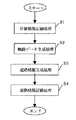
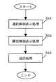
以上の道路情報をカーナビゲーション装置に追加登録する処理の大きな流れを、図4を用いて説明する。
まず、SW8がオンされてからオフされるまでの間、道路形成用位置情報として位置情報記憶処理(ステップ(以下、Sと略す)1)が実行される。道路情報形成用位置情報として時間的に連続して記憶された位置情報に基いて、軌跡データを生成するための軌跡データ生成処理が実行される(S2)。そして、生成された軌跡データに基づいて道路情報を生成するための道路情報生成処理が実行される(S3)。道路情報は、予め決められた線幅で画面上に道路として表示されるように、軌跡データに基づいて道路画像を形成することによって生成される。最後に、生成された道路情報を追加地図情報記憶部72に記憶するための道路情報記憶処理が実行される(S4)。
【0034】
図5及び図6は、車の位置情報を記憶する位置情報記憶処理(S1)の流れの例を示すフローチャートである。
図5は、SW8をオンしてから、オフするまでの間の位置情報を記憶する処理の例を示すフローチャートである。図5の処理は、SW8がオンされると実行される。
【0035】
図5に示すように、SW8がオンされると、道路情報形成用の位置情報として、その時の位置情報が位置情報記憶部3aに記憶される(S11)。そして、SW8がオフされたか否かが判断され(S12)、SW8がオフされないと、処理は、S11の処理へ戻り、位置情報が記憶される。SW8がオフされると、S2でYESとなって、処理は終了する。
従って、SW8がオンされてからオフされるまで、時間的に連続して車の位置情報が位置情報記憶部3aに記憶される。道路形成用位置情報として記憶された位置情報に基づいて、車の軌跡データ生成処理(S2)が実行される。
【0036】
図5の処理は、SW8がオンされたオフされるまで、位置情報を記憶する位置情報を記憶する記憶処理が実行されるものである。
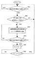
図6は、既存の道路を走行中にSW8をオンにしても、自動的に新設された道路のみの位置情報を記憶する処理の流れの例を示すフローチャートである。図6の処理は、SW8がオンされると実行される。
【0037】
SW8がオンされると、位置認識部4からの情報に基く車の現在位置が、HDD7の基本地図情報記憶部71と追加地図情報記憶部72に記憶されている道路情報に係る既存の道路上にあるか否かが判断される(S21)。車の現在位置が、既存の道路上にあれば、S21でYESとなって、処理は何もしないで、S21の判断処理に戻る。車の現在位置がその既存の道路上になくなると、S21でNOとなって、車の進行方向が一定角度以上変化したか否かが判断される(S22)。
【0038】
図7は、車の進行方向が一定角度以上変化したか否かの判断をする場合を説明するための図である。車が、一点鎖線L1で示すように、進行方向V1に従って、道路R3上を移動してきて、現在位置Pにあるとする。その後、車が進行方向をV1からV2へ変更したとすると、進行方向が予め設定された一定角度θ1(例えば30度)よりも大きい角度θ2で変化すると、S22でYESとなって、処理はS23へ移行する。
【0039】
車の進行方向が予め設定された一定角度θ1以上変化したか否かは、ある時点(例えばP)まで位置情報の軌跡の辿ってきた方向ベクトル(V1)と、その時点(例えばP)からその後予め決められた時間内に得られた軌跡の辿ってきた方向ベクトル(V2)とのなす角度(θ2)が、予め設定された角度(θ1)以上であるか否かによって判断される。
従って、車の現在位置が地図情報に含まれる既存の道路上になく、かつ車の進行方向が一定角度以上変化した場合に、現在位置が、地図情報に含まれる道路情報についての道路上にないと判断して、処理はS23へ移行する。
【0040】
位置情報の軌跡の方向が予め決められた角度θ1以上変化しなければ、S22でNOとなって、処理はS21ヘ戻る。車の進行方向が一定角度θ1以上変化すると、S22でYESとなり、既存の道路から外れた位置からの位置情報を、道路情報形成用位置情報として記憶する(S23)。そして、車の現在位置が既存の道路上にあるか否かが判断される(S24)。車の現在位置が既存の道路上になければ、S24でNOとなり、処理はS23の処理へ戻り、位置情報が記憶される。車の現在位置が既存の道路上にあれば、S24でYESとなり、予め決められた時間が経過するとタイムアウトするタイマをオンする(S25)。タイマをオンした後、一定時間経過してタイムアウトしたか否かが判断され(S26)、タイムアウトしなければ、タイムアウトするまで処理は何もしない。タイムアウトすると、S26でYESとなって、処置はS21へ戻る。このような処理によれば、確実に現在位置が道路上にないと判断することができる。
【0041】
その結果、既存の道路上にないときのみ、道路形成用位置情報として車が通過してきた位置情報が記憶され、収集される。すなわち、ユーザはSW8を押した後、自動的に既存の道路上にないところだけの位置情報を記憶することができる。そして、道路形成用位置情報として記憶された位置情報に基づいて、車の軌跡データ生成処理(S2)が実行される。
【0042】
図6の処理は、SW8がオンされた後、現在位置が既存の道路から外れたか否かの判断処理と、現在位置が既存の道路上にないときに位置情報を記憶する位置情報を記憶する記憶処理と、記憶された位置情報に基いて道路情報を生成し、記憶する道路情報の生成と記憶処理とが実行されるものである。そして、SW8がオフされると、上述した、判断処理と、位置情報記憶処理と、道路情報生成記憶処理は、実行されない。
【0043】
なお、図6の処理は、SW8をオンにした場合に実行されるが、カーナビゲーション装置において、常に図6の処理を実行するようにしてもよい。SW8を設けずに、常に図6の処理を実行するようにすると、ユーザは、画面を見て後から新設された道路であったことを知ることになることもあるが、ユーザが意識せずに、新設された道路を登録することができる。
図5及び図6で記憶された位置情報に基づいて、図4のS2、S3の処理が行われて、道路情報が追加登録される。
以上のようにして、収集された位置データに基づいて生成された道路情報に、その道路について各種情報、例えば、車線数、規制等の情報を、追加して記入したり、他のユーザ等へその道路情報を送信したり、メモリカード等に道路情報を出力することができる。
【0044】
図8は、カーナビゲーション装置のLCD10に表示される操作画面例を示す図である。ユーザは、カーナビゲーション装置のリモートコントローラ(以下、リモコンという)等を用いて各種機能を実行させることができる。以下の説明では、画面上のボタン選択、機能実行等も指示は、リモコンで行われる場合で説明するが、画面上のボタン選択、機能実行等の指示は、他の方法であってもよい。リモコン上の各種キーを操作することによって、画面上のカーソルの移動、ボタン選択等が行われる。
【0045】
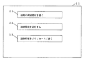
ユーザが、1)新設された道路の関連情報を記憶する、2)自己のカーナビゲーション装置に登録された新設道路の道路情報を友人等のカーナビゲーション装置に送信する、あるいは3)自己のカーナビゲーション装置に登録された新設道路の道路情報を可搬記録媒体であるメモリカードに記録する、という機能を実行する場合、ユーザは、まずリモコンを用いて図8の画面を表示させる。
【0046】
図8の画面11上には、3つのボタン21、22、23が表示されている。ユーザは画面上のボタンを選択し、例えば、リモコンに設けられたOKキーボタンを押すと、選択されたボタンの機能が実行される。
21は、「道路の関連情報を書く」ボタンであり、図4の処理によって、追加して登録された道路情報に関して、ユーザが、各種関連情報、例えば、車線数、規制等の情報を、追加して登録したりするためのボタンである。
【0047】
22は、「道路情報を送信する」ボタンであり、ユーザが、自己のカーナビゲーション装置に登録された新設道路の道路情報及び関連情報を友人等のカーナビゲーション装置に送信するためのボタンである。
23は、「道路情報をメモリカードに書く」ボタンであり、自己のカーナビゲーション装置に登録された新設道路の道路情報及び関連情報を、可搬記録媒体であるメモリカードに記録するためのボタンである。道路情報が記録されたメモリカードは、他のユーザのカーナビゲーション装置へ装着して、記録されている道路情報をダウンロードすれば、その他のユーザのカーナビゲーション装置においても、追加された道路情報を利用することができる。
【0048】
「道路の関連情報を書く」ボタン21が選択されて、リモコンのOKキーボタンが押されると、LCD10の表示は、図8の画面から図9の画面に移行する。
図9は、追加地図情報記憶部72に追加登録された道路情報に、ユーザが関連情報を入力するための道路情報選択画面の例を示す図である。図9に示すように、リスト表示された道路情報毎に、その道路の場所情報31aと追加登録された時刻情報31bが表示される。ここでは、道路の場所情報は、市町村名であり、時間は、追加登録された年月日が表示されるようになっている。道路の場所情報は、基本地図情報記憶部71に記憶された場所情報に基いて、追加された道路に最も近い場所の市町村名をその場所情報とする。追加地図情報記憶部72に道路情報が追加登録された時に、カーナビゲーション装置に内蔵された時計の時刻情報も併せて登録することによって、時刻情報の年月日の情報とする。
【0049】
図9の画面上で、カーソルを移動して、ユーザは関連情報を登録させたい道路を選択し、リモコンのOKキーボタンを押すことによって、カーソルで選択された道路を含む地図が、図10に示すようにLCD11の画面上に表示される。図10は、ユーザが選択された道路の位置を確認できるようにするための地図が表示された画面を示す図である。
【0050】
図10において、選択された道路、すなわち関連情報を入力したい道路が点線で表示されている。なお、図10では選択された道路が点線で示されているが、他の道路の色と違う色で示すようにしてもよい。ユーザは、点線で示された道路を確認し、リモコン上のOKキーボタンを押すと、画面表示は、図11の画面に移行する。ユーザが、図9において、例えば、31に示す道路情報を選択したとする。
【0051】
図11は、追加情報記憶部72に追加登録された道路情報について、道路の種別等の関連情報を入力するための画面の例を示す図である。画面中には、道路の場所と登録された時刻を表示する場所・時刻表示部41と、道路の種別を入力するための種別入力フィールド42と、道理に関する規制を入力するための規制入力フィールド43を含む。ユーザは、種別入力フィールド42と規制入力フィールド43に、リモコンを用いて情報を入力することができる。
【0052】
種別入力フィールド42には、例えば、国道、県道、4車線道路、2車線道路等の道路の種別情報が入力される。
規制入力フィールド43には、例えば、一方通行、通行禁止時間帯、冬季閉鎖、速度規制等の規制情報が入力される。
種別入力フィールド42と規制入力フィールド43の両方に、あるいは一方にユーザが関連情報を入力し、ユーザがリモコン上のOKキーボタンを押すと、入力された関連情報は、選択された道路情報に関連付けられて追加情報記憶部72に追加登録され、その後、画面表示は、図9の画面に移行し、さらに他の道路にも関連情報を入力することができる。
【0053】
よって、ユーザが登録した道路の種別及び規制のデータは、その後ユーザがその道路を通行するときに、カーナビゲーション装置のLCD11の画面上に表示させる等して利用することができる。
以上の説明した「道路の関連情報を書く」ボタン21が選択されることによって実行される関連情報入力処理の流れについて図12を用いて説明する。図12は、関連情報入力処理の流れの例を示すフローチャートである。
【0054】
「道路の関連情報を書く」ボタン21が選択されると、図9の画面を表示し、画面の中から関連情報を選択させるための選択画面表示処理が実行される(S31)。S31の処理後、図10の画面を表示し、関連情報を書く対象道路の地図上の位置を確認させるための確認画面表示処理が実行される(S32)。そして、図11の画面を表示して、種別入力フィールド42と規制入力フィールド43にユーザが関連情報を入力できるようにし、かつ入力された関連情報を、選択された道路情報に関連付けて、追加情報記憶部72に登録するための入力画面表示処理が実行される(S33)。
【0055】
なお、図11の画面における情報入力は、道路情報を追加登録した後、ユーザが車を停止しているときに、リモコン操作を行うことによって、道路の種別等の関連情報を入力することができる。
さらに、図8において、「道路情報を送信する」ボタン22が選択されると、図9の画面と同様の画面を表示して、送信したい道路情報をユーザに選択させた後に、画面表示は、図13の画面に移行する。図13は、送信先表示画面の例を示す図である。図13では、予め登録された相手を選択するための送信先がリスト表示される。ユーザは、図13の画面上で、カーソルを移動して、送信したい相手を選択し、リモコンのOKキーボタンを押すことによって、カーソルで選択された相手に道路情報が送信される。送信先毎に相手先の電話番号情報がHDD7の予め決められた記憶領域に記憶されているので、送信先が選択されて送信を実行する指示がされると、通信手段に接続された携帯電話を介して、相手の携帯電話に、追加情報記憶部72に記憶された道路情報が送信される。
【0056】
図13では、送信先が、「Aさん」のボタン51と、「Bさん」のボタン52と、「センタ」のボタン53が示されている。ユーザが、自分が自己のカーナビゲーション装置に追加登録した地図情報を、例えば、友人の「Aさん」へ送信したいときは、ボタン51を選択して、リモコン装置のOKキーボタンを押すことによってHDD7の追加情報データ部72に追加登録された道路情報が通信手段を介して送信される。Aさんが所有するカーナビゲーション装置も、図1と同様の構成であり、通信手段を介して受信したデータを追加情報データ部72に追加登録する。
【0057】
なお、道路情報の送信は、添付ファイルを含む電子メール送信でもよい。この場合、送信先の電子メールアドレスに、道路情報を添付ファイルとして付加した電子メールが送信されるので、受信した送信先の装置において、添付ファイルの情報が、カーナビゲーション装置がダウンロードできるように加工されて、加工されたデータがカーナビゲーション装置に取り込まれる。
【0058】
また、「センタ」のボタン53を選択すると、道路情報はセンタへ送信される。そして、地図情報のデータベースを持つセンタに一旦、道路情報が登録され、そのセンタに登録された道路情報が、他のユーザによってダウンロードすることができるようにしてもよい。
以上説明した「道路情報を送信する」ボタン22が選択されたときに実行される処理の流れを説明する。図14は、道路情報送信処理の流れの例を示すフローチャートである。
【0059】
まず、図9に示すような、道路情報の選択画面を表示し、画面の中から、送信する道路情報を選択させるための選択画面表示処理が実行される(S41)。S41の処理後、図10の画面を表示し、送信する対象道路の地図上の位置を確認させるための確認画面表示処理が実行される(S42)。そして、次に、図13の画面を表示して、送信先を選択させて、選択された道路情報を、選択された送信先に送信するための送信処理が実行される(S43)。
【0060】
また、上述したように、カーナビゲーション装置は、他のカーナビゲーション装置から道路情報を受信すると、受信した道路情報のデータを追加情報記憶部72に追加登録する。従って、ユーザは、他のユーザが生成して登録した道路情報を受信して登録することによって、他のユーザが生成した道路情報も利用することができる。
【0061】
さらになお、カーナビゲーション装置を搭載した車同士が接近したときに、相手方のカーナビゲーション装置を検出すると、データ通信によりカーナビゲーション装置間で相互に追加登録された道路情報を交換するようにしてもよい。
図8において、「道路情報をメモリカードに書く」ボタン23が選択されると、図9と同様の画面が表示され、ユーザは、可搬記録媒体に出力したい道路情報を選択する。図9において道路情報が選択されると、可搬記録媒体記録制御部5に挿入されたメモリカード等の可搬記録媒体に、選択された道路情報が出力される。
【0062】
道路情報が記録されたメモリカードは、可搬記録媒体記録制御部5から取り外し、例えば友人の所有するカーナビゲーション装置の可搬記録媒体記録制御部に挿入し、そのメモリカードから道路情報をダウンロードしてメモリカードを友人に渡すことによって、その友人のカーナビゲーション装置においても、追加登録された道路情報についての道路も含む地図が表示される。
【0063】
このような追加登録された道路情報を他のカーナビゲーション装置へ送信することによって、あるいは可搬記録媒体を介して、カーナビゲーション装置間で相互に交換できるので、ユーザ間で新設された道路の情報を迅速に利用することができる。
以上説明したように、本実施の形態によれば、従来のように、更新された地図情報が供給されるまで、新設された道路の情報をカーナビゲーション装置において利用できなということはなく、所定の動作の下で、新設された道路を通るだけで道路情報が登録され、その後すぐにその追加登録された道路情報が反映された地図を利用することができる。
【0064】
さらに、自己が追加登録した道路情報を他のユーザと通信等によって交換することによって、ユーザ相互間ですばやく新設された道路情報を利用することができる。
なお、以上説明した動作を実行するプログラムは、フロッピー(登録商標)ディスク、CD−ROM等の可搬媒体や、ハードディスク等の記憶装置等に、その全体あるいは一部が記録され、あるいは記憶されている。そのプログラムがコンピュータにより読み取られて、動作の全部あるいは一部が実行される。あるいは、そのプログラムの全体あるいは一部を通信ネットワークを介して流通または提供することができる。利用者は、通信ネットワークを介してそのプログラムをダウンロードしてコンピュータにインストールしたり、あるいは記録媒体からコンピュータにインストールすることで、容易に本発明の地図情報更新装置を実現することができる。
【0065】
本発明は、上述した実施の形態に限定されるものではなく、本発明の要旨を変えない範囲において、種々の変更、改変等が可能である。
【図面の簡単な説明】
【図1】本実施形態に係わるカーナビゲーション装置のブロック構成図。
【図2】本実施形態に係わるカーナビゲーション装置の表示地図の例を示す図。
【図3】本実施形態に係わるカーナビゲーション装置の表示地図の例を示す図。
【図4】道路情報を追加登録する処理の大きな流れを示すフローチャート。
【図5】位置情報記憶処理の流れの例を示すフローチャート。
【図6】位置情報記憶処理の流れの例を示すフローチャート。
【図7】車の進行方向の変化を判断をする場合を説明するための図。
【図8】カーナビゲーション装置の操作画面例を示す図。
【図9】関連情報を入力するための道路情報選択画面の例を示す図。
【図10】道路位置確認のための地図が表示された画面を示す図。
【図11】道路の種別等の関連情報を入力するための画面の例を示す図。
【図12】関連情報入力処理の流れの例を示すフローチャート。
【図13】送信先表示画面の例を示す図。
【図14】道路情報送信処理の流れの例を示すフローチャート。
【符号の説明】
1 CPU、2 ROM、3 RAM、4 位置認識部、5 可搬記録媒体記録制御部5、6 映像制御部、7 地図情報記憶部、8 書き込みモード切替スイッチ、9 通信制御部[0001]
TECHNICAL FIELD OF THE INVENTION
The present invention relates to a map information updating device, a map information updating method, and a program, and particularly relates to a map information updating device, a map information updating method, and a program for updating a map based on position information.
[0002]
[Prior art]
Conventionally, one of the problems when using a car navigation device is that since the map information stored in the device has not been updated, the map displayed by the car navigation device and the moving car There is a location mismatch. For example, when a car passes on a newly-established road, the car is traveling on a place where there is no road on the map displayed by the car navigation device because the newly established road information is not included in the map information. Will be displayed.
[0003]
Therefore, in order to solve such a problem, when a new road is constructed, updated map information including information on the newly constructed road is taken into the car navigation device from outside through communication, and the stored map information is retrieved. A device for updating has been proposed (for example, see Patent Document 1). According to this method, the updated road information is stored in the car navigation device, so that the user can use the car navigation device by using the latest map information in which the newly established road is also displayed. it can.
[0004]
As another solution, a car navigation device equipped with a car generates travel locus data of a road on which a car actually travels, transmits the generated travel locus data to an information center, and the information center generates the travel locus data based on the received travel locus data. A system has been proposed in which the map information is updated by a vehicle and the updated map information is distributed to a car navigation device of a car (for example, see Patent Document 2). According to this system, the road map information of the car navigation device can be updated quickly and at low cost without performing aerial photography of road information, field survey, and the like.
[0005]
[Patent Document 1]
JP-A-8-95488 (
[0006]
[Patent Document 2]
JP-A-2002-54934 (pages 6 to 7, FIG. 1)
[0007]
[Problems to be solved by the invention]
However, in the former method in which the car navigation device acquires updated map information from outside by communication, there is a problem that the user cannot use the latest map information until the map information is updated. That is, roads that are not included in the map information are not displayed until the map information is updated, so that the user cannot use the car navigation device to pass through a newly established road.
[0008]
In the latter method, if information information is used to create road information using travel locus information from a user and the road information is directly delivered from the information center, for example, the user may manage to pass an extremely bad road. There will be roads for other users up to the road that was created, and when actually going there, there may be cases where roads that can only pass cars such as trucks can not be passed by ordinary passenger cars. .
[0009]
Therefore, an object of the present invention is to provide a map information updating device in which map information is updated only by a user passing without obtaining updated map information from the outside.
[0010]
[Means for Solving the Problems]
A map information updating device according to the present invention includes: a map information storage unit that stores map information; and a road information included in the map information, based on the road information and the current position information included in the map information. Determining means for determining whether or not the current position is on the road, and when the determining means determines that the current position is not on the road, storing the position information of the current position in a position information storage unit. Position information storage means for performing the operation, road information generation means for generating road information based on the position information stored in the position information storage section, and the road information generated by the road information generation means, Road information storage means for storing in the information storage unit.
[0011]
In the map information updating method according to the present invention, based on the road information and the current position information included in the map information stored in the map information storage unit, the current position is determined on the road with respect to the road information included in the map information. Is determined, and as a result of the determination, when the current position is not on the road, the position information of the current position is stored in the position information storage unit, and the position information is stored in the position information storage unit. Road information is generated based on the position information, and the generated road information is stored in the map information storage unit.
[0012]
The program according to the present invention stores the current position on the road based on the road information included in the map information stored in the map information storage unit and the information on the current position, based on the road information included in the map information. A function of determining whether or not the current position is located on the road, and a function of storing position information of the current position in a position information storage unit when the current position is not on the road; And a program for realizing a function of generating road information based on the position information stored in the map information storage unit and a function of storing the generated road information in the map information storage unit.
According to such a configuration, it is possible to realize a map information updating apparatus in which map information is updated only by a user passing without obtaining updated map information from the outside.
[0013]
Further, in the map information updating device of the present invention, information of a road type or a road regulation is further input in order to store the information related to the road information stored in the map information storage unit in the map information storage unit. It is desirable to have a related information input means for causing the information to be input.
According to such a configuration, when using the car navigation device, it is possible to display and use road-related information.
[0014]
Further, in the map information updating device of the present invention, further, the road information generated by the road information generating means and stored in the map information storage unit is transmitted via the wireless communication means and the communication means. It is desirable to have road information transmitting means.
According to such a configuration, newly registered road information can be transmitted to another user, and another user can also use the road information.
[0015]
Further, the map information updating apparatus of the present invention further includes a wireless communication unit, wherein the road information storage unit stores the road information, which has received the road information, via the communication unit, in the map information storage unit. It is desirable to memorize it.
According to such a configuration, the user can use the road information generated by another user by receiving and registering the road information generated and registered by the other user.
[0016]
In the map information updating device of the present invention, the road information generated by the road information generating unit and stored in the map information storage unit is recorded on a portable recording medium. It is desirable to have.
According to such a configuration, another user can use the portable recording medium in which the newly registered road information is recorded and handed over to another user.
[0017]
Further, in the map information updating apparatus of the present invention, the determining means includes: a direction vector that a locus of the position information has traced to the current position; and a position vector obtained within a predetermined time thereafter from the current position. It is desirable to determine that the current position is not on the road when the angle formed by the direction vector followed by the information trajectory changes by a predetermined angle or more.
According to such a configuration, it can be reliably determined that the current position is not on the road.
[0018]
Further, the map information updating apparatus of the present invention further comprises a switch, wherein when the switch is on, the determination unit, the position information storage unit, the road information generation unit, Executing the road information storage means, and when the switch is off, the determination means, the position information storage means, the road information generation means, and the road information storage means may not be executed. desirable.
According to such a configuration, after the user presses the switch, the position information of only the part not existing on the existing road is automatically stored, and the road information can be generated and registered.
[0019]
Further, the map information updating device of the present invention further includes a map display control means for extracting map information from the map information storage unit and displaying the map information as an image on a display device, wherein the map display control means It is preferable that the road information generated by the information generating means and stored in the map information storage unit is displayed on the display device in a color different from the color of the other road information.
According to such a configuration, the user can clearly recognize the road related to the additionally registered road information while distinguishing it from other roads.
[0020]
BEST MODE FOR CARRYING OUT THE INVENTION
Hereinafter, a map information updating device according to an embodiment of the present invention will be described with reference to the drawings.
First, a configuration of a car navigation device as an example of a map information updating device according to the present embodiment will be described with reference to FIG. FIG. 1 is a block diagram showing a configuration example of a car navigation device according to the present embodiment. A car navigation device having the configuration shown in FIG. 1 is mounted on a car.
[0021]
[0022]
The
The
[0023]
The
[0024]
The portable recording
The image control unit 6 is for controlling a liquid crystal display (LCD) 11 connected to the image control unit 6, and displays an image to be displayed by the map display control software executed by the
[0025]
The
[0026]
The
The communication control unit 9 transmits the road information additionally registered in the
[0027]
Next, a method of updating map information using the car navigation device of FIG. 1 will be specifically described.
FIG. 2 is a diagram illustrating an example of a map displayed on the LCD 10 of the car navigation device. The map displayed on the LCD 10 is generated by map display control software. Reference numeral 11 denotes a frame of a screen displayed on the LCD 10. In the screen 11, a solid line indicates a road displayed based on road information stored in the
[0028]
The car driven by the user is equipped with the car navigation device shown in FIG. The position of the car on the map is indicated by a star P. The user drives the car depending on the map on the screen 11 and the position P of the car, which change moment by moment as the car moves.
For example, it is assumed that a user discovers a newly established road R5 connecting the roads R3 and R4 on a certain day. In FIG. 2, the road R5 is indicated by a dotted line. An example of a case where the user actually passes through the road R5 again after the discovery and additionally registers the road information of the road R5 in the car navigation device will be described below.
[0029]
As shown by a dashed-dotted line L1 in FIG. 2, the user passes from the existing road R1 to the road R3, turns right from the middle of the road R3, and enters the newly established road R5. In that case, the user pushes SW8 on at the time point PS when the vehicle turns right from the road R3 and enters the road R5. Then, when the vehicle passes through the road R5 and enters the existing road R4 on the map, at the time PE, the user presses the SW8 again to turn it off.
While the switch SW8 is turned on after being turned on, the position information from the
[0030]
When the switch SW8 is turned off, road information is generated based on the position information stored in the position information storage unit 3a, and the generated road information is additionally registered in the additional
[0031]
Therefore, when the vehicle of the user subsequently passes near the road R5, the road R5 is displayed as shown in FIG. 3, so that the user can recognize the road R5. In FIG. 3, the road R5 may be displayed in a different color from the color of the other roads R1 and the like. For example, the color of the road stored in the basic map
[0032]
In the above-described example, road information during a period from when the user turns on the SW8 to when the switch is turned off is added. However, when it is not easy for the user to turn the SW8 on and off while driving. There is also. Therefore, instead of storing the position information of the period until the
[0033]
A large flow of the process of additionally registering the road information in the car navigation device will be described with reference to FIG.
First, a position information storage process (step (hereinafter abbreviated as S) 1) is executed as road formation position information from when the
[0034]
5 and 6 are flowcharts illustrating an example of the flow of the position information storage process (S1) for storing the position information of the vehicle.
FIG. 5 is a flowchart illustrating an example of processing for storing position information from when the
[0035]
As shown in FIG. 5, when the switch SW8 is turned on, the position information at that time is stored in the position information storage unit 3a as the position information for forming the road information (S11). Then, it is determined whether or not the
Therefore, the position information of the vehicle is stored in the position information storage unit 3a continuously continuously from the time when the
[0036]
In the process of FIG. 5, a storage process of storing position information for storing position information is performed until the
FIG. 6 is a flowchart illustrating an example of a flow of processing for automatically storing position information of only a newly established road even when the
[0037]
When the
[0038]
FIG. 7 is a diagram for explaining a case where it is determined whether or not the traveling direction of the vehicle has changed by a certain angle or more. It is assumed that the car has moved on the road R3 according to the traveling direction V1 and is at the current position P as indicated by the dashed line L1. Thereafter, assuming that the traveling direction of the vehicle changes from V1 to V2, if the traveling direction changes at an angle θ2 that is larger than a predetermined fixed angle θ1 (for example, 30 degrees), “YES” is determined in S22, and the process proceeds to S23. Move to.
[0039]
Whether or not the traveling direction of the car has changed by a predetermined angle θ1 or more is determined by the direction vector (V1) from which the trajectory of the position information has been traced up to a certain point (for example, P) and the time after that point (for example, P). The determination is made based on whether or not the angle (θ2) between the trajectory obtained within the predetermined time and the direction vector (V2) followed by the trajectory is equal to or larger than the predetermined angle (θ1).
Therefore, when the current position of the car is not on an existing road included in the map information and the traveling direction of the car changes by a certain angle or more, the current position is not on the road for the road information included in the map information. Is determined, and the process proceeds to S23.
[0040]
If the direction of the trajectory of the position information does not change by the predetermined angle θ1 or more, the result in S22 is NO, and the process returns to S21. If the traveling direction of the vehicle changes by the predetermined angle θ1 or more, the result of S22 is YES, and the position information from the position deviating from the existing road is stored as road information forming position information (S23). Then, it is determined whether the current position of the car is on an existing road (S24). If the current position of the car is not on the existing road, the result in S24 is NO, the process returns to the process in S23, and the position information is stored. If the current position of the car is on an existing road, YES is determined in S24, and a timer that times out after a predetermined time has elapsed is turned on (S25). After turning on the timer, it is determined whether or not a predetermined time has elapsed and a timeout has occurred (S26). If the timeout has not occurred, no processing is performed until the timeout occurs. If a timeout occurs, the determination at S26 becomes YES, and the procedure returns to S21. According to such processing, it can be reliably determined that the current position is not on the road.
[0041]
As a result, only when the vehicle is not on an existing road, the positional information on which the car has passed is stored and collected as road forming positional information. That is, after the user presses SW8, it is possible to automatically store only the position information that is not on the existing road. Then, a vehicle trajectory data generation process (S2) is executed based on the position information stored as the road forming position information.
[0042]
The process of FIG. 6 is a process of determining whether or not the current position deviates from an existing road after the SW8 is turned on, and stores position information for storing position information when the current position is not on an existing road. The storage processing and the road information are generated based on the stored position information, and the generation and storage processing of the road information to be stored are executed. When the
[0043]
Although the process of FIG. 6 is executed when the
Based on the position information stored in FIGS. 5 and 6, the processes in S2 and S3 in FIG. 4 are performed, and the road information is additionally registered.
As described above, in the road information generated based on the collected position data, various types of information on the road, for example, information such as the number of lanes and regulations, are additionally entered, and the information is transmitted to other users. The road information can be transmitted, or the road information can be output to a memory card or the like.
[0044]
FIG. 8 is a diagram illustrating an example of an operation screen displayed on the LCD 10 of the car navigation device. The user can execute various functions using a remote controller (hereinafter, referred to as a remote controller) of the car navigation device. In the following description, it is assumed that the instruction for button selection, function execution, and the like on the screen is performed by the remote controller. However, the instruction for button selection, function execution, and the like on the screen may be another method. By operating various keys on the remote controller, cursor movement on the screen, button selection, and the like are performed.
[0045]
The user 1) stores the related information of the newly established road, 2) transmits the road information of the newly established road registered in the own car navigation device to the car navigation device such as a friend, or 3) own car navigation. When executing the function of recording road information of a new road registered in the device on a memory card as a portable recording medium, the user first displays the screen of FIG. 8 using a remote controller.
[0046]
On the screen 11 in FIG. 8, three
[0047]
[0048]
When the “write road related information”
FIG. 9 is a diagram illustrating an example of a road information selection screen for the user to input related information to the road information additionally registered in the additional map
[0049]
By moving the cursor on the screen of FIG. 9, the user selects a road for which related information is to be registered, and presses the OK key button of the remote control to display a map including the road selected by the cursor in FIG. It is displayed on the screen of the LCD 11 as shown. FIG. 10 is a diagram showing a screen on which a map is displayed so that the user can confirm the position of the selected road.
[0050]
In FIG. 10, the selected road, that is, the road to which related information is to be input is displayed by a dotted line. In FIG. 10, the selected road is indicated by a dotted line, but may be indicated by a color different from the colors of other roads. When the user confirms the road indicated by the dotted line and presses the OK key button on the remote control, the screen display shifts to the screen of FIG. Assume that the user selects the road information indicated by 31, for example, in FIG.
[0051]
FIG. 11 is a diagram illustrating an example of a screen for inputting related information such as a type of road for road information additionally registered in the additional
[0052]
In the
In the
When the user inputs relevant information to both or one of the
[0053]
Therefore, the data of the road type and the regulation registered by the user can be used, for example, by displaying it on the screen of the LCD 11 of the car navigation device when the user passes through the road.
The flow of the related information input process executed by selecting the above-described “write road related information”
[0054]
When the “write road related information”
[0055]
In the information input on the screen of FIG. 11, after the road information is additionally registered, when the user stops the car, the user can input the relevant information such as the type of the road by performing the remote control operation. .
Further, in FIG. 8, when the “send road information”
[0056]
In FIG. 13, the transmission destination includes a button 51 of “Mr. A”, a button 52 of “Mr. B”, and a button 53 of “Center”. When the user wants to transmit the map information additionally registered in his / her own car navigation device to, for example, a friend “Mr. The road information additionally registered in the additional
[0057]
The transmission of the road information may be an electronic mail including an attached file. In this case, an e-mail in which road information is added as an attached file to the e-mail address of the transmission destination is transmitted, and the received transmission destination device processes the attached file information so that the car navigation device can download it. Then, the processed data is taken into the car navigation device.
[0058]
When the "center" button 53 is selected, the road information is transmitted to the center. Then, road information may be temporarily registered in a center having a database of map information, and the road information registered in the center may be downloaded by another user.
The flow of the processing executed when the “send road information”
[0059]
First, a road information selection screen as shown in FIG. 9 is displayed, and a selection screen display process for selecting road information to be transmitted from the screen is executed (S41). After the processing of S41, the screen of FIG. 10 is displayed, and a confirmation screen display processing for confirming the position of the target road to be transmitted on the map is executed (S42). Then, the screen of FIG. 13 is displayed, a transmission destination is selected, and transmission processing for transmitting the selected road information to the selected transmission destination is performed (S43).
[0060]
Further, as described above, when receiving the road information from another car navigation device, the car navigation device additionally registers the received data of the road information in the additional
[0061]
Furthermore, when vehicles equipped with a car navigation device approach each other, when a car navigation device of the other party is detected, mutually registered road information may be exchanged between the car navigation devices by data communication. .
In FIG. 8, when the "write road information to memory card"
[0062]
The memory card on which the road information is recorded is removed from the portable recording medium
[0063]
By transmitting such additionally registered road information to another car navigation device or via a portable recording medium, the information can be exchanged between the car navigation devices. Can be used quickly.
As described above, according to the present embodiment, the information of the newly established road is not available in the car navigation device until the updated map information is supplied as in the related art. Under the operation of (1), road information is registered simply by passing through a newly established road, and immediately after that, a map in which the additionally registered road information is reflected can be used.
[0064]
Furthermore, by exchanging the road information additionally registered by oneself with other users by communication or the like, the newly established road information can be quickly used between the users.
The program for performing the above-described operations is recorded in whole or in part or in a portable medium such as a floppy (registered trademark) disk or a CD-ROM, or a storage device such as a hard disk. I have. The program is read by the computer, and all or a part of the operation is executed. Alternatively, the whole or a part of the program can be distributed or provided via a communication network. The user can easily realize the map information updating device of the present invention by downloading the program via a communication network and installing the program on a computer, or installing the program on a computer from a recording medium.
[0065]
The present invention is not limited to the above-described embodiment, and various changes and modifications can be made without departing from the spirit of the present invention.
[Brief description of the drawings]
FIG. 1 is a block configuration diagram of a car navigation device according to an embodiment.
FIG. 2 is a diagram showing an example of a display map of the car navigation device according to the embodiment.
FIG. 3 is a diagram showing an example of a display map of the car navigation device according to the embodiment.
FIG. 4 is a flowchart showing a large flow of processing for additionally registering road information.
FIG. 5 is a flowchart illustrating an example of the flow of a position information storage process.
FIG. 6 is a flowchart illustrating an example of the flow of a position information storage process.
FIG. 7 is a diagram for explaining a case in which a change in the traveling direction of a car is determined.
FIG. 8 is a diagram showing an example of an operation screen of the car navigation device.
FIG. 9 is a diagram showing an example of a road information selection screen for inputting related information.
FIG. 10 is a diagram showing a screen on which a map for confirming a road position is displayed.
FIG. 11 is a diagram showing an example of a screen for inputting related information such as a type of a road.
FIG. 12 is a flowchart illustrating an example of the flow of a related information input process.
FIG. 13 is a diagram showing an example of a destination display screen.
FIG. 14 is a flowchart illustrating an example of the flow of road information transmission processing.
[Explanation of symbols]
Claims (10)
前記地図情報に含まれる道路情報と現在位置の情報とに基き、該現在位置が、前記地図情報に含まれる前記道路情報についての道路上にあるか否かを判断する判断手段と、
該判断手段によって、前記現在位置が前記道路上にないと判断されたときに、前記現在位置の位置情報を位置情報記憶部に記憶する位置情報記憶手段と、
前記位置情報記憶部に記憶された前記位置情報に基いて、道路情報を生成する道路情報生成手段と、
該道路情報生成手段によって生成された前記道路情報を、前記地図情報記憶部に記憶する道路情報記憶手段とを有することを特徴とする地図情報更新装置。A map information storage unit for storing map information;
Determining means for determining whether or not the current position is on a road for the road information included in the map information, based on the road information and the information on the current position included in the map information;
Position information storage means for storing position information of the current position in a position information storage unit when the determination means determines that the current position is not on the road;
Road information generating means for generating road information based on the position information stored in the position information storage unit;
A road information storage unit for storing the road information generated by the road information generation unit in the map information storage unit.
該通信手段を介して、前記道路情報生成手段によって生成され、前記地図情報記憶部に記憶された前記道路情報を送信する道路情報送信手段とを有することを特徴とする請求項1又は請求項2に記載の地図情報更新装置。Further, a wireless communication means,
3. A road information transmitting unit that transmits the road information generated by the road information generating unit and stored in the map information storage unit via the communication unit. The map information updating device according to 1.
前記道路情報記憶手段は、前記通信手段を介して、前記道路情報を受信した道路情報を、前記地図情報記憶部に記憶することを特徴とする請求項1、請求項2又は請求項3に記載の地図情報更新装置。Furthermore, it has a wireless communication means,
The said road information storage means stores the road information which received the said road information via the said communication means in the said map information storage part, The Claim 4 characterized by the above-mentioned. Map information updating device.
該スイッチがオンとなっている場合には、前記判断手段と、前記位置情報記憶手段と、前記道路情報生成手段と、前記道路情報記憶手段とを実行し、
前記スイッチがオフとなっている場合には、前記判断手段と、前記位置情報記憶手段と、前記道路情報生成手段と、前記道路情報記憶手段が実行されないことを特徴とする請求項1から請求項6のいずれかに記載の地図情報更新装置。In addition, it has a switch,
When the switch is turned on, the determination unit, the position information storage unit, the road information generation unit, and the road information storage unit is executed,
The method according to claim 1, wherein when the switch is turned off, the determination unit, the position information storage unit, the road information generation unit, and the road information storage unit are not executed. 6. The map information updating device according to any one of 6.
前記地図表示制御手段は、前記道路情報生成手段によって生成され前記地図情報記憶部に記憶された前記道路情報を、他の前記道路情報の色とは異なる色で、前記表示装置上に表示させることを特徴とする請求項1から請求項7のいずれかに記載の地図情報更新装置。Further, a map display control means for extracting map information from the map information storage unit and displaying the map information as an image on a display device,
The map display control unit displays the road information generated by the road information generation unit and stored in the map information storage unit on the display device in a color different from the color of the other road information. The map information updating device according to any one of claims 1 to 7, wherein:
該判断の結果、前記現在位置が前記道路上にないときに、前記現在位置の位置情報を位置情報記憶部に記憶し、
前記位置情報記憶部に記憶された前記位置情報に基いて道路情報を生成し、
生成された前記道路情報を前記地図情報記憶部に記憶することを特徴とする地図情報更新方法。Based on the road information and the current position information included in the map information stored in the map information storage unit, determine whether the current position is on the road for the road information included in the map information,
As a result of the determination, when the current position is not on the road, the position information of the current position is stored in a position information storage unit,
Generating road information based on the position information stored in the position information storage unit;
A map information updating method, wherein the generated road information is stored in the map information storage unit.
地図情報記憶部に記憶された地図情報に含まれる道路情報と現在位置の情報とに基き、該現在位置が、前記地図情報に含まれる道路情報についての道路上にあるか否かを判断する機能と、
該判断の結果、前記現在位置が前記道路上にないときに、前記現在位置の位置情報を位置情報記憶部に記憶する機能と、
前記位置情報記憶部に記憶された前記位置情報に基いて道路情報を生成する機能と、
生成された前記道路情報を前記地図情報記憶部に記憶する機能を実現させるためのプログラム。On the computer,
A function of determining whether or not the current position is on a road based on the road information included in the map information, based on the road information included in the map information stored in the map information storage unit and the information on the current position. When,
As a result of the determination, when the current position is not on the road, a function of storing position information of the current position in a position information storage unit;
A function of generating road information based on the position information stored in the position information storage unit;
A program for realizing a function of storing the generated road information in the map information storage unit.
Priority Applications (1)
| Application Number | Priority Date | Filing Date | Title |
|---|---|---|---|
| JP2002375580A JP2004205379A (en) | 2002-12-25 | 2002-12-25 | Map information updating device, map information updating method and program |
Applications Claiming Priority (1)
| Application Number | Priority Date | Filing Date | Title |
|---|---|---|---|
| JP2002375580A JP2004205379A (en) | 2002-12-25 | 2002-12-25 | Map information updating device, map information updating method and program |
Publications (1)
| Publication Number | Publication Date |
|---|---|
| JP2004205379A true JP2004205379A (en) | 2004-07-22 |
Family
ID=32813266
Family Applications (1)
| Application Number | Title | Priority Date | Filing Date |
|---|---|---|---|
| JP2002375580A Withdrawn JP2004205379A (en) | 2002-12-25 | 2002-12-25 | Map information updating device, map information updating method and program |
Country Status (1)
| Country | Link |
|---|---|
| JP (1) | JP2004205379A (en) |
Cited By (1)
| Publication number | Priority date | Publication date | Assignee | Title |
|---|---|---|---|---|
| JP2020056917A (en) * | 2018-10-02 | 2020-04-09 | トヨタ自動車株式会社 | Map information system |
-
2002
- 2002-12-25 JP JP2002375580A patent/JP2004205379A/en not_active Withdrawn
Cited By (3)
| Publication number | Priority date | Publication date | Assignee | Title |
|---|---|---|---|---|
| JP2020056917A (en) * | 2018-10-02 | 2020-04-09 | トヨタ自動車株式会社 | Map information system |
| US11409728B2 (en) | 2018-10-02 | 2022-08-09 | Toyota Jidosha Kabushiki Kaisha | Map information system |
| JP7147442B2 (en) | 2018-10-02 | 2022-10-05 | トヨタ自動車株式会社 | map information system |
Similar Documents
| Publication | Publication Date | Title |
|---|---|---|
| JP5172048B2 (en) | Navigation device and portable information terminal | |
| JP4666066B2 (en) | Map data utilization device | |
| JP3748042B2 (en) | Navigation device | |
| JP2004354149A (en) | Map data delivery method | |
| JP5187905B2 (en) | Route guidance apparatus and program | |
| JP2005265572A (en) | Operation method for on-vehicle information terminal, on-vehicle information terminal, program for portable terminal, and portable phone | |
| JP2006018086A (en) | Car navigation device, and system and server for updating map data thereof | |
| JP2004239727A (en) | On-vehicle navigation device | |
| JP6747098B2 (en) | Server device, communication terminal, information distribution system, and computer program | |
| JP2004205379A (en) | Map information updating device, map information updating method and program | |
| JP7082588B2 (en) | Programs, navigation systems, navigation devices | |
| JP3785639B2 (en) | Navigation method and apparatus, and computer program therefor | |
| JP4444002B2 (en) | Navigation device and navigation method | |
| JP4218009B2 (en) | Vehicle route guidance information presentation system, presentation method, and program | |
| JP2005181062A (en) | MAP DISPLAY DEVICE, MAP INFORMATION UPDATE METHOD, AND PROGRAM | |
| WO2006077698A1 (en) | Display controller | |
| JP4050020B2 (en) | Navigation device and program | |
| JP2001074491A (en) | Navigation device, portable terminal device, and recording medium recording computer program for them | |
| JP4264010B2 (en) | NAVIGATION DEVICE, INFORMATION PRESENTATION METHOD, AND NAVIGATION PROGRAM | |
| JP3801467B2 (en) | Navigation device | |
| JP2004301525A (en) | Navigation system | |
| JP2009103702A (en) | Map display device | |
| JP3846588B2 (en) | Navigation device | |
| KR20250076432A (en) | A location updating system for a vehicle and a process for updating location | |
| JP2002208097A (en) | Automotive electronics |
Legal Events
| Date | Code | Title | Description |
|---|---|---|---|
| A300 | Withdrawal of application because of no request for examination |
Free format text: JAPANESE INTERMEDIATE CODE: A300 Effective date: 20060307 |