EP4521061A1 - Position estimation device, position estimation method, and program - Google Patents
Position estimation device, position estimation method, and program Download PDFInfo
- Publication number
- EP4521061A1 EP4521061A1 EP22940807.5A EP22940807A EP4521061A1 EP 4521061 A1 EP4521061 A1 EP 4521061A1 EP 22940807 A EP22940807 A EP 22940807A EP 4521061 A1 EP4521061 A1 EP 4521061A1
- Authority
- EP
- European Patent Office
- Prior art keywords
- flying object
- position estimation
- images
- image
- target image
- Prior art date
- Legal status (The legal status is an assumption and is not a legal conclusion. Google has not performed a legal analysis and makes no representation as to the accuracy of the status listed.)
- Withdrawn
Links
Images




Classifications
-
- G—PHYSICS
- G01—MEASURING; TESTING
- G01C—MEASURING DISTANCES, LEVELS OR BEARINGS; SURVEYING; NAVIGATION; GYROSCOPIC INSTRUMENTS; PHOTOGRAMMETRY OR VIDEOGRAMMETRY
- G01C3/00—Measuring distances in line of sight; Optical rangefinders
- G01C3/02—Details
- G01C3/06—Use of electric means to obtain final indication
-
- G—PHYSICS
- G06—COMPUTING OR CALCULATING; COUNTING
- G06T—IMAGE DATA PROCESSING OR GENERATION, IN GENERAL
- G06T7/00—Image analysis
- G06T7/60—Analysis of geometric attributes
- G06T7/62—Analysis of geometric attributes of area, perimeter, diameter or volume
-
- G—PHYSICS
- G06—COMPUTING OR CALCULATING; COUNTING
- G06T—IMAGE DATA PROCESSING OR GENERATION, IN GENERAL
- G06T7/00—Image analysis
- G06T7/70—Determining position or orientation of objects or cameras
- G06T7/73—Determining position or orientation of objects or cameras using feature-based methods
- G06T7/74—Determining position or orientation of objects or cameras using feature-based methods involving reference images or patches
-
- G—PHYSICS
- G01—MEASURING; TESTING
- G01P—MEASURING LINEAR OR ANGULAR SPEED, ACCELERATION, DECELERATION, OR SHOCK; INDICATING PRESENCE, ABSENCE, OR DIRECTION, OF MOVEMENT
- G01P3/00—Measuring linear or angular speed; Measuring differences of linear or angular speeds
- G01P3/36—Devices characterised by the use of optical means, e.g. using infrared, visible, or ultraviolet light
- G01P3/38—Devices characterised by the use of optical means, e.g. using infrared, visible, or ultraviolet light using photographic means
-
- G—PHYSICS
- G06—COMPUTING OR CALCULATING; COUNTING
- G06T—IMAGE DATA PROCESSING OR GENERATION, IN GENERAL
- G06T7/00—Image analysis
- G06T7/20—Analysis of motion
-
- G—PHYSICS
- G06—COMPUTING OR CALCULATING; COUNTING
- G06T—IMAGE DATA PROCESSING OR GENERATION, IN GENERAL
- G06T7/00—Image analysis
- G06T7/20—Analysis of motion
- G06T7/246—Analysis of motion using feature-based methods, e.g. the tracking of corners or segments
- G06T7/248—Analysis of motion using feature-based methods, e.g. the tracking of corners or segments involving reference images or patches
-
- G—PHYSICS
- G06—COMPUTING OR CALCULATING; COUNTING
- G06T—IMAGE DATA PROCESSING OR GENERATION, IN GENERAL
- G06T7/00—Image analysis
- G06T7/20—Analysis of motion
- G06T7/292—Multi-camera tracking
-
- G—PHYSICS
- G06—COMPUTING OR CALCULATING; COUNTING
- G06T—IMAGE DATA PROCESSING OR GENERATION, IN GENERAL
- G06T7/00—Image analysis
- G06T7/70—Determining position or orientation of objects or cameras
-
- G—PHYSICS
- G01—MEASURING; TESTING
- G01C—MEASURING DISTANCES, LEVELS OR BEARINGS; SURVEYING; NAVIGATION; GYROSCOPIC INSTRUMENTS; PHOTOGRAMMETRY OR VIDEOGRAMMETRY
- G01C3/00—Measuring distances in line of sight; Optical rangefinders
- G01C3/02—Details
- G01C3/06—Use of electric means to obtain final indication
- G01C3/08—Use of electric radiation detectors
-
- G—PHYSICS
- G06—COMPUTING OR CALCULATING; COUNTING
- G06T—IMAGE DATA PROCESSING OR GENERATION, IN GENERAL
- G06T2207/00—Indexing scheme for image analysis or image enhancement
- G06T2207/20—Special algorithmic details
- G06T2207/20076—Probabilistic image processing
-
- G—PHYSICS
- G06—COMPUTING OR CALCULATING; COUNTING
- G06T—IMAGE DATA PROCESSING OR GENERATION, IN GENERAL
- G06T2207/00—Indexing scheme for image analysis or image enhancement
- G06T2207/30—Subject of image; Context of image processing
- G06T2207/30232—Surveillance
-
- G—PHYSICS
- G06—COMPUTING OR CALCULATING; COUNTING
- G06T—IMAGE DATA PROCESSING OR GENERATION, IN GENERAL
- G06T2207/00—Indexing scheme for image analysis or image enhancement
- G06T2207/30—Subject of image; Context of image processing
- G06T2207/30241—Trajectory
Definitions
- the present invention relates to a position estimation device, a position estimation method, and a program.
- Patent Document 1 performs each of a recognition of a flight of a bird, a calculation of a position of the bird that has flown, and an estimation of a presence position of the bird that has flown after a predetermined time from two pieces of image data obtained by the two camera modules, and supplies a sound signal to a plurality of speaker modules such that the sound reaches the estimated position.
- Patent Document 1 Japanese Unexamined Patent Publication No. 10-4858
- An example of an object of the present invention is to enable estimation of a position of a flying object even with one imaging device in consideration of the above-described problems.
- a position estimation device including an image acquisition unit that acquires a plurality of images generated by an imaging device that images a target space that is a space in which a flying object flies, and a position estimation unit that estimates a position of the flying object by processing the plurality of images, in which the position estimation unit (1) provisionally sets a type of the flying object, (2) specifies three or more of the images arranged in time series as a target image group, (3) estimates a distance from the imaging device to the flying object for each of a plurality of the images included in the target image group by using the provisionally set type and an area of the flying object in the image belonging to the target image group, (4) calculates a change rate in the area of the flying object between the plurality of the images included in the target image group, (5) estimates a speed of the flying object by using the distance to the flying object and a position in the image in each of the plurality of the images included in the target image group, (6) updates the type of the flying object by using the speed
- a method of estimating a position of a flying object by the position estimation device, and a program for implementing the position estimation device are also provided.
- a position of a flying object can be estimated even with one imaging device.
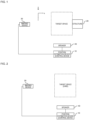
- Fig. 1 is a diagram for describing a first example of a use environment of a position estimation device 10 according to an embodiment.
- the position estimation device 10 is a device that detects a flying object that is present in a periphery of a structure 20 and estimates a position of the flying object.
- the position estimation device 10 uses an image generated by one imaging device 30.
- a target space is included in an imaging range of the imaging device 30.
- the target space includes a region in which the flying object is not allowed to enter.
- An example of the region is the periphery of the structure 20.
- the target space may include the structure 20 or may not include the structure 20.
- the target space includes, for example, both the structure 20 and a space within 2 km from the structure 20. However, depending on the type of the imaging device 30, the target space can include a space within 10 km from the structure 20.
- a representative example of the flying object is an animal such as a bird.
- the flying object may be another object, for example, an airplane, a helicopter, or an object that is lifted by wind.
- the structure 20 is, for example, a wind power generation device, but may be other equipment such as an iron tower.
- the structure 20 When the structure 20 has a mechanical or electrical structure, the structure is controlled by a control device.
- the structure 20 When the structure 20 is a wind power generation device, the structure is a blade.
- the position estimation device 10 transmits predetermined information (control information described below) to the control device to stop or slow down the movement of the mechanical or electrical structure. Then, the control device slows down or stops the movement of the above-described structure.
- the imaging device 30 is a monocular camera. It is preferable that the imaging device 30 has a tilt function, a pan function, and a zoom function (hereinafter, referred to as a TPZ function). It is desirable that the installation position of the imaging device 30 is fixed. In addition, the frame rate of the image generated by the imaging device 30 is optional.
- the imaging device 30 may transmit, together with the generated image, a setting value of the imaging device 30 when the image is generated, for example, a focal length, to the position estimation device 10.
- the installation position of the imaging device 30 may be determined using, for example, simulation. In this case, when an angle of view, an installation position, and a direction of a camera of the imaging device 30 are input to a simulation device, a range in which the imaging device 30 can perform imaging can be calculated. Then, when the calculation result is used, an appropriate installation position of the imaging device 30 can be estimated.
- the position estimation device 10 estimates a current position of the flying object and estimates a future position of the flying object.
- the position estimation device 10 controls a speaker 40 such that the sound reaches the animal at a timing at which the animal reaches the future position. That is, the position estimation device 10 also functions as a control device of the speaker 40. In this case, the position estimation device 10 outputs a sound for transmitting predetermined information to the animal from the speaker 40.
- An example of the sound output by the position estimation device 10 to the speaker 40 is a sound for transmitting predetermined information from the same species of the detected animal to the animal or a sound for transmitting predetermined information from the closely related species of the detected animal to the animal.
- An example of the predetermined information transmitted by the sound is information that can change the behavior of the animal, for example, a sound for transmitting that a natural enemy is approaching, or a sound for transmitting that a prey is in another place or direction.
- the sound output by the speaker 40 is a sound for transmitting that the predator is approaching.
- the sound output by the speaker 40 is a sound for transmitting that an animal that can be preyed upon is in another place. That is, the position estimation device 10 changes the sound according to the type of the detected animal.
- the speaker 40 has directivity.
- An example of the speaker 40 is a parametric speaker.
- the orientation of the speaker 40 is variable. Then, the position estimation device 10 controls the direction of the speaker 40 such that the emission direction of the speaker 40 is directed toward the future position of the animal.
- Fig. 2 is a diagram for describing a second example of the use environment of the position estimation device 10.
- the position estimation device 10 controls the speaker 40 to predict the future position of an animal that is trying to invade a specific land (hereinafter, referred to as a target region) and to prevent the animal from invading the target region.
- the target animal is, for example, a wild boar, a deer, a monkey, a mouse, or a closely related species thereof, and is an animal that causes so-called wildlife damage.
- the "flying object" is replaced with "animal".
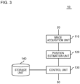
- Fig. 3 is a diagram showing an example of a functional configuration of the position estimation device 10.
- the position estimation device 10 includes an image acquisition unit 110 and a position estimation unit 120.
- the image acquisition unit 110 acquires a plurality of images captured by the imaging device 30.
- the position estimation unit 120 estimates the position of the flying object by processing the plurality of images.
- the position estimation unit 120 performs the following processing.
- the estimated position of the flying object at a timing at which the image is captured is indicated by the position of the flying object in the image and the distance calculated based on the image.
- the position estimation unit 120 uses the focal length used when the imaging device 30 generates the image.
- the position estimation unit 120 calculates an average value of areas of regions occupied by the flying object between the image currently being processed and at least one other image belonging to the target image group, and estimates a distance using the average value.
- the position estimation unit 120 further generates motion information indicating a motion state of the flying object.
- the motion information includes at least one of a turning radius, an angular velocity, an acceleration, or an angular acceleration when a trajectory of the flying object is approximated to an arc.
- the center of the turning radius is the position of the imaging device 30.
- the position estimation unit 120 estimates the future position of the flying object.
- the future position is an estimation result of the position of the flying object at a first timing in the future.
- the first timing is a predetermined time after the current time.
- the predetermined time is, for example, a value of 1/120 seconds or more and 5 seconds or less. It may be longer than the above-mentioned.
- the position estimation unit 120 uses the position, the speed, and the motion information of the flying object, and time-series information of at least one of these.
- the position estimation device 10 also functions as a control device that controls the speaker 40, and thus includes a control unit 130 and a storage unit 140.
- the control unit 130 causes the speaker 40 to output a sound for transmitting predetermined information to the animal at the first timing such that the sound reaches the future position.
- predetermined information is as described with reference to Fig. 1 .
- the storage unit 140 stores data that is a sound source of the sound output by the speaker 40.
- the data will be referred to as sound data.
- the storage unit 140 stores the sound data for each type of animal, for example, for each species.
- the control unit 130 reads out the sound data corresponding to the type of the animal detected by the position estimation unit 120 from the storage unit 140 and outputs the sound data from the speaker 40.
- the speaker 40 has directivity, and the direction of the speaker 40 is variable.
- the control unit 130 controls the orientation of the speaker 40.
- the control unit 130 controls the orientation of the speaker 40 such that the emission direction of the speaker 40 is directed toward the future position of the animal.
- Fig. 4 is a diagram showing an example of a hardware configuration of the position estimation device 10.
- the position estimation device 10 includes a bus 1010, a processor 1020, a memory 1030, a storage device 1040, an input and output interface 1050, and a network interface 1060.
- the bus 1010 is a data transmission path for transmitting and receiving data between the processor 1020, the memory 1030, the storage device 1040, the input and output interface 1050, and the network interface 1060.
- a method for connecting the processor 1020 or the like is not limited to bus connection.
- the processor 1020 is a processor implemented by a central processing unit (CPU), a graphics processing unit (GPU), or the like.
- the memory 1030 is a main storage device that is implemented using a random access memory (RAM) or the like.
- the storage device 1040 is an auxiliary storage device that is implemented using a hard disk drive (HDD), a solid state drive (SSD), removable media such as a memory card, a read only memory (ROM), or the like.
- the storage device 1040 stores a program module that implements each function (for example, the image acquisition unit 110, the position estimation unit 120, and the control unit 130) of the position estimation device 10.
- the processor 1020 reads and executes each of the program modules on the memory 1030, so that each function corresponding to the program module is implemented.
- the storage device 1040 also functions as the storage unit 140.
- the input and output interface 1050 is an interface for connecting the position estimation device 10 and various input and output devices.
- the position estimation device 10 may communicate with at least one of the imaging device 30 or the speaker 40 through the input and output interface 1050.
- the network interface 1060 is an interface for connecting the position estimation device 10 to a network.
- the network is, for example, a local area network (LAN) or a wide area network (WAN).
- a method for connecting the network interface 1060 to the network may be a wireless connection or a wired connection.
- the position estimation device 10 may communicate with at least one of the imaging device 30 or the speaker 40 through the network interface 1060.
- Fig. 5 is a diagram for describing an example of processing performed by the position estimation device 10.
- the imaging device 30 generates the repeated images.
- the imaging device 30 immediately transmits an image to the position estimation device 10 each time the image is generated.
- the image acquisition unit 110 of the position estimation device 10 acquires the plurality of images and stores the plurality of images in a storage unit, for example, the storage unit 140.
- the position estimation unit 120 determines whether or not the image includes the flying object. For the processing, for example, processing of determining whether or not an object that moves in the image is present is used. Then, when the flying object is included, the processing shown in the present figure is started.
- the position estimation unit 120 provisionally sets the type of the flying object.
- the processing corresponds to (1) described with reference to Fig. 2 .
- the type that is set here is specified up to the species of the animal (step S10).
- the position estimation unit 120 selects a predetermined number of images from the images stored in the storage unit 140.
- the predetermined number is at least three, but may be greater than three.
- a plurality of images selected here will be referred to as the target image group.
- the plurality of images constituting the target image group are consecutive in time series, and all include the flying object.
- the initially generated target image group is constituted with an image in which the flying object is initially included and two images generated thereafter (step S20).
- the processing corresponds to (2) described with reference to Fig. 2 .
- the position estimation unit 120 estimates a distance from the imaging device 30 to the flying object at a timing at which the image is captured (step S30).
- the estimated position of the flying object at a timing at which each image is generated is indicated by the position of the flying object in the image and the distance calculated based on the image.
- the processing corresponds to (3) described with reference to Fig. 2 .
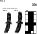
- Fig. 6 is a diagram for describing the step S30.
- the absolute size of the flying object falls within a predetermined range that is set for each type even in consideration of individual differences. Therefore, the proportion of the area occupied by the flying object in the image (for example, the number of pixels) changes depending on the distance from the imaging device 30 to the flying object. Specifically, as the distance from the imaging device 30 to the flying object increases, the proportion of the area occupied by the flying object in the image decreases.
- the position estimation unit 120 estimates the distance from the imaging device 30 to the flying object by using the relationship.
- the proportion of the area occupied by the flying object in the image also changes depending on the focal length of the imaging device 30. Therefore, when the focal length of the imaging device 30 is variable, it is preferable that the position estimation unit 120 uses the focal length of the imaging device 30 when the image is generated, in a case where the distance from the imaging device 30 to the flying object is calculated.
- the position estimation unit 120 estimates the speed of the flying object, the turning radius when the trajectory of the flying object is approximated to an arc, the angular velocity, the acceleration, and the angular acceleration by using the position of the flying object at each timing at which each image is captured (step S40).
- the processing corresponds to (3) and (5) described with reference to Fig. 2 .
- the position of the flying object calculated in the step S30 indicates the trajectory of the flying object. By using the trajectory, the turning radius of the flying object can be estimated. In addition, when the amount of change in the position of the flying object between at least two images adjacent to each other on the time axis is used, the speed and the acceleration of the flying object can be estimated. In addition, when the turning radius of the flying object and the amount of change in the position of the flying object between the two images are used, the angular velocity and the angular acceleration of the flying object can be estimated.
- the position estimation unit 120 can perform the estimation shown in the step S40, for example, on images other than an image that is first positioned on the time axis among the plurality of images constituting the target image group.
- the position estimation unit 120 calculates a change rate in the area occupied by the flying object calculated in the step S30 and calculates an average value of the areas (step S50).
- the processing corresponds to (4) described with reference to Fig. 2 .
- the position estimation unit 120 performs the following processing except for an image positioned last on the time axis among the plurality of images constituting the target image group. First, a ratio of an area of the flying object in the image to an area of the flying object in the next image is set as an area change rate. Then, an average value of the two areas is calculated. The area change rate and the average value are set to be positioned in the middle of the timings at which the two images are generated, on the time axis. When the step S50 is performed, the number of data is decreased by one on the time axis.
- the position estimation unit 120 repeats the processing of the step S30 to the step S50 by using the average value of the areas calculated in the step S50 until a first criterion is satisfied (step S60).
- An example of the first criterion is that the processing of the step S30 to the step S50 is repeated a predetermined number of times.
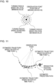
- Fig. 7 is a diagram for describing the processing shown in the step S20 to the step S60 of Fig. 5 .
- the target image group is constituted with ten images.
- Fig. 7(A) shows a movement path (trajectory) of the flying object on the image, that is, a trajectory projected on an xy plane
- each diagram of Fig. 7(B) shows a distance from the imaging device 30 to the flying object, that is, an estimated path of the flying object projected on the xz plane.
- An x-axis and a y-axis indicate two axes constituting the image, and a z-axis indicates a direction away from the imaging device 30 as shown in Fig. 1 .
- the number of data is one less on the time axis. Therefore, each time the processing shown in the step S20 to the step S50 is repeated, the number of measurement points, that is, the number of measurement timings indicating the estimated movement path is decreased by one. On the other hand, the estimation accuracy of the distance, that is, the estimation accuracy of the position of the flying object is increased.
- step S70 the position estimation unit 120 determines whether or not it is necessary to update the target image group.
- An example of a case in which it is necessary to update the target image group is, for example, that there is an image that has not yet been selected as the target image group.
- a case where the image acquisition unit 110 acquires a new image from the imaging device 30 is an example of a case where it is necessary to update the target image group.
- step S70: Yes the position estimation unit 120 updates the target image group (step S20) and repeats the processing shown in the step S30 to the step S70.
- a method of updating the target image group is a first-in first-out method. That is, the position estimation unit 120 removes an image, which is the oldest in time series among the images included in the current target image group, from the target image group. Then, the position estimation unit 120 specifies the latest image among the images included in the current target image group, and newly adds an image positioned next to the image in time series to the target image group. That is, each target image group corresponds to a timing at which the latest image in the target image group is captured.
- the position estimation unit 120 calculates a moving average of each value calculated in the step S40 to the step S50 (step S80).
- the processing corresponds to the processing performed between (5) and (6) shown in Fig. 2 .
- the position estimation unit 120 estimates the future position of the flying object by using the moving average of the position and the speed (step S90).
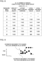
- Figs. 8 to 11 are diagrams for describing a detailed example of the step S90.
- the position estimation unit 120 calculates a K-point moving average of the area of the flying object, a local minimum value at the K-point, and a local maximum value at the K-point for each target image group. Specifically, the position estimation unit 120 calculates the K-point moving average of the area of the flying object and associates the calculated average with the most recent image in time series among the images used in calculating the moving average. In addition, the position estimation unit 120 recognizes the area of the flying object in each of K images used when the moving average is calculated. Then, the position estimation unit 120 associates each of the local minimum value and the local maximum value of K areas with the most recent image in time series among the images used when the moving average is calculated. As a result, the local minimum value and the local maximum value of the area are associated with each of the plurality of images.
- the position estimation unit 120 specifies, for each target image group, an estimated movement path of the flying object based on the local minimum value of the area (hereinafter, referred to as a first estimated movement path) and an estimated movement path based on the local maximum value of the area (hereinafter, referred to as a second estimated movement path).
- the first estimated movement path indicates a movement path when an estimated distance from the imaging device 30 to the flying object is the maximum value of an estimated range (that is, when the flying object is farthest from the imaging device 30).
- the second estimated movement path indicates a movement path when the estimated distance from the imaging device 30 to the flying object is the minimum value of the estimated range (that is, when the flying object is closest to the imaging device 30).
- a range sandwiched between the two estimated movement paths indicates the estimated range of the movement path of the flying object.
- the flying object flies in the estimated range with a high probability. From the above, the estimated movement path of the flying object can be indicated in a band shape.
- the position estimation unit 120 specifies an estimated movement path (hereinafter, referred to as a third estimated movement path) based on the moving average of the area.
- the third estimated movement path is positioned between the first estimated movement path and the second estimated movement path.
- the position estimation unit 120 calculates, in each target image group, a turning radius indicating the first estimated movement path (the local minimum value of the area), a turning radius indicating the second estimated movement path (the local maximum value of the area), and a turning radius indicating the third estimated movement path (the moving average of the area).
- the position estimation unit 120 superimposes the estimated movement paths based on each of the plurality of target image groups.
- Each of the plurality of target image groups corresponds to a time point (t 0 , t 1 , t 2 , ...) at which the latest image in the target image group is captured.
- Each estimated movement path is shown as an arc centered at the position of the imaging device 30 and having a radius based on the third estimated movement path. Then, the position estimation unit 120 estimates the future movement path of the flying object by using the transition of the estimated movement path, and estimates the future position of the flying object by using the movement path. As an example, the position estimation unit 120 can estimate the future position of the flying object by using a Kalman filter. In this case, the future position of the flying object can be predicted although there is a missing value. In addition, the robustness of the prediction of the future position is also improved.
- the moving average of each of the position, the speed, and the motion information of the flying object is used for calculating the estimated movement path. Therefore, the moving average of each of the position, the speed, and the motion information of the flying object is substantially used for predicting the future position of the flying object.
- the future position of the flying object in each estimated movement path, may be estimated based on a first estimated latitude path (that is, a path farthest from the imaging device 30), and the future position of the flying object may be estimated based on a second estimated latitude path (that is, a path closest to the imaging device 30).
- the position estimation unit 120 may calculate the future position to be actually used by using the two future positions. As an example, the position estimation unit 120 may use an average position of the two future positions as the future position actually used.
- the position estimation unit 120 estimates the type of the flying object by using the speed and the area change rate in the flying object (step S100). Both the speed and the area change rate indicate the feature of the movement of the flying object. For example, when the flying object is a bird, the range of the speed is determined by the species of the bird, and the features of the movement of the wing during flapping and the movement during the turning are changed depending on the species of the bird. Therefore, the position estimation unit 120 can specify the type of the flying object by using the speed and the area change rate.
- the position estimation unit 120 performs estimation up to the species. The processing corresponds to (6) described with reference to Fig. 2 .
- the criterion is suitable when it is necessary to proceed with the processing by the position estimation unit 120 at a certain speed.
- the criterion indicates that a difference between a predicted result of the future position (corresponding to the future position generated before the first timing among the above) and a measured value (corresponding to the estimated position at the first timing among the above) is equal to or less than the criterion value, and indicates that the accuracy is sufficiently increased.
- the above-described second criterion is switchable according to an input from the user, for example.
- the control unit 130 reads out sound data corresponding to the species of the animal from the storage unit 140.
- the control unit 130 directs the orientation of the speaker 40 to the future position specified in the step S90.
- the control unit 130 causes the speaker 40 to output the sound data read out from the storage unit 140 (step S120).
- the control unit 130 controls the timing of emitting the sound such that the sound reaches the future position at a timing at which the flying object is expected to reach the future position.
- the sound output from the speaker 40 is a sound for transmitting the predetermined information to the animal.
- the animal changes the movement direction according to the information. As a result, the animal does not enter the region that should not be entered. In this case, it is not necessary to intimidate the animal by the size of the sound. Therefore, the size of the sound output from the speaker 40 is smaller than that in related art.
- the position and the future position of the flying object can be estimated even with one imaging device.
- the flying object is an animal such as a bird
- the sound output by the speaker 40 is small, the animal can be prevented from entering the region in which the animal should not enter.
- Fig. 12 is a diagram for describing a use environment of the position estimation device 10 according to the present modification example.
- the position estimation device 10 is used together with the one imaging device 30.
- the position estimation device 10 is used together with a plurality of imaging devices 30, preferably three or more of the imaging devices 30.
- the plurality of imaging devices 30 are disposed to be separated from each other, and include a target space (or target region) in an imaging range. That is, the plurality of imaging devices 30 image the target space from different directions.
- all of the plurality of imaging devices 30 are monocular cameras. In this case, the cost of the imaging device 30 is reduced.
- the image acquisition unit 110 of the position estimation device 10 acquires a plurality of images from the plurality of imaging devices 30, and the position estimation unit 120 of the position estimation device 10 calculates information indicating the estimated position of the flying object for each of the plurality of imaging devices 30 and specifies the estimated position of the flying object by using the information for each of the imaging devices 30.
- An example of the information indicating the estimated position of the flying object is the turning radius described with reference to Fig. 10 .
- the position estimation unit 120 performs processing up to the calculation of a turning radius for each of the plurality of imaging devices 30. Then, the position estimation unit 120 specifies the estimated position of the flying object by using the calculation results of the plurality of turning radiuses.
- Fig. 13 is a diagram for describing an example of a method of specifying the estimated position of the flying object by the position estimation unit 120.
- the position estimation unit 120 calculates the turning radius for each of the plurality of imaging devices 30. Then, the position estimation unit 120 draws a circle centered at the position of the imaging device 30 and having a radius that is a turning radius corresponding to the imaging device 30 for each of the plurality of imaging devices 30. Then, the position estimation unit 120 estimates that the flying object is present at a place in which the plurality of circles overlap each other.
- the position estimation unit 120 may calculate the position of the flying object in the real space for each of the plurality of imaging devices 30 by using the distance calculated in the step S30 and the position of the flying object in the image, and may set an average value of the calculation results as the estimated position of the flying object.
- the position estimation unit 120 may calculate the band-shaped estimated movement path shown in Fig. 9 for each of the plurality of imaging devices 30, and may specify the estimated movement path to be actually used by estimating that the flying object is present in a region in which the plurality of estimated movement paths overlap. In this case, since the accuracy of the estimated movement path is increased, the estimation accuracy of the future position of the flying object is also increased.
- the position estimation unit 120 specifies a trajectory of the flying object by using the transition of the estimated position, and estimates the future position by using the trajectory. Then, the control unit 130 causes the speaker 40 to emit a sound after the speaker 40 is directed to the future position.
- the position estimation device 10 estimates the position of the flying object by using the images captured by the plurality of imaging devices 30. Therefore, the estimation accuracy of the position of the flying object is increased.
- all of the plurality of imaging devices 30 can use monocular cameras. Therefore, the estimation accuracy of the position of the flying object can be increased while the cost of the imaging device 30 is suppressed.
Landscapes
- Engineering & Computer Science (AREA)
- Physics & Mathematics (AREA)
- General Physics & Mathematics (AREA)
- Theoretical Computer Science (AREA)
- Computer Vision & Pattern Recognition (AREA)
- Electromagnetism (AREA)
- Multimedia (AREA)
- Power Engineering (AREA)
- Geometry (AREA)
- Radar, Positioning & Navigation (AREA)
- Remote Sensing (AREA)
- Image Analysis (AREA)
- Length Measuring Devices By Optical Means (AREA)
Applications Claiming Priority (1)
| Application Number | Priority Date | Filing Date | Title |
|---|---|---|---|
| PCT/JP2022/019497 WO2023214445A1 (ja) | 2022-05-02 | 2022-05-02 | 位置推定装置、位置推定方法、及びプログラム |
Publications (1)
| Publication Number | Publication Date |
|---|---|
| EP4521061A1 true EP4521061A1 (en) | 2025-03-12 |
Family
ID=88646389
Family Applications (1)
| Application Number | Title | Priority Date | Filing Date |
|---|---|---|---|
| EP22940807.5A Withdrawn EP4521061A1 (en) | 2022-05-02 | 2022-05-02 | Position estimation device, position estimation method, and program |
Country Status (7)
| Country | Link |
|---|---|
| US (1) | US20250349030A1 (cg-RX-API-DMAC7.html) |
| EP (1) | EP4521061A1 (cg-RX-API-DMAC7.html) |
| JP (1) | JPWO2023214445A1 (cg-RX-API-DMAC7.html) |
| KR (1) | KR20250005289A (cg-RX-API-DMAC7.html) |
| CN (1) | CN119365751A (cg-RX-API-DMAC7.html) |
| CA (1) | CA3257270A1 (cg-RX-API-DMAC7.html) |
| WO (1) | WO2023214445A1 (cg-RX-API-DMAC7.html) |
Cited By (1)
| Publication number | Priority date | Publication date | Assignee | Title |
|---|---|---|---|---|
| CN121995947A (zh) * | 2026-04-08 | 2026-05-08 | 四川傲势科技有限公司 | 无人机控制方法、装置及电子设备 |
Family Cites Families (4)
| Publication number | Priority date | Publication date | Assignee | Title |
|---|---|---|---|---|
| JPH104858A (ja) | 1996-06-21 | 1998-01-13 | Takenaka Komuten Co Ltd | 鳥類飛来防止装置 |
| JP6183703B2 (ja) * | 2013-09-17 | 2017-08-23 | 日本電気株式会社 | 物体検出装置、物体検出方法および物体検出システム |
| CA2947138A1 (en) * | 2014-05-07 | 2015-11-12 | Nec Corporation | Object detection device, object detection method, and object detection system |
| US20160055399A1 (en) * | 2014-08-21 | 2016-02-25 | Identiflight, Llc | Graphical display for bird or bat detection and identification |
-
2022
- 2022-05-02 US US18/861,726 patent/US20250349030A1/en active Pending
- 2022-05-02 JP JP2024519147A patent/JPWO2023214445A1/ja not_active Ceased
- 2022-05-02 CA CA3257270A patent/CA3257270A1/en active Pending
- 2022-05-02 KR KR1020247037851A patent/KR20250005289A/ko active Pending
- 2022-05-02 WO PCT/JP2022/019497 patent/WO2023214445A1/ja not_active Ceased
- 2022-05-02 CN CN202280095688.9A patent/CN119365751A/zh not_active Withdrawn
- 2022-05-02 EP EP22940807.5A patent/EP4521061A1/en not_active Withdrawn
Cited By (1)
| Publication number | Priority date | Publication date | Assignee | Title |
|---|---|---|---|---|
| CN121995947A (zh) * | 2026-04-08 | 2026-05-08 | 四川傲势科技有限公司 | 无人机控制方法、装置及电子设备 |
Also Published As
| Publication number | Publication date |
|---|---|
| CA3257270A1 (en) | 2025-04-22 |
| WO2023214445A1 (ja) | 2023-11-09 |
| JPWO2023214445A1 (cg-RX-API-DMAC7.html) | 2023-11-09 |
| US20250349030A1 (en) | 2025-11-13 |
| CN119365751A (zh) | 2025-01-24 |
| KR20250005289A (ko) | 2025-01-09 |
Similar Documents
| Publication | Publication Date | Title |
|---|---|---|
| EP3876070B1 (en) | Method and device for planning path of unmanned aerial vehicle, and unmanned aerial vehicle | |
| CN110069071B (zh) | 无人机导航方法与装置、存储介质、电子设备 | |
| CN116719339A (zh) | 一种基于无人机的电力线路巡检控制方法及系统 | |
| EP4027318B1 (en) | Probability-based obstacle avoidance | |
| EP3521158A1 (en) | Flight control device, unmanned aerial vehicle, flight control method, and computer-readable recording medium | |
| CN112884900B (zh) | 无人机的降落定位方法、装置、存储介质及无人机机巢 | |
| WO2020139481A1 (en) | Collision avoidance system, depth imaging system, vehicle, obstacle map generator, and methods thereof | |
| KR20170007353A (ko) | 물체 검출 장치, 물체 검출 방법, 및 물체 검출 시스템 | |
| CN112001309B (zh) | 基于无人机集群的目标搜索方法、装置、设备及存储介质 | |
| CN120406516B (zh) | 无人机的避障方法、存储介质、任务机及无人机系统 | |
| CN116907282A (zh) | 基于人工智能算法的无人靶机超低空飞行控制方法 | |
| CN113924598A (zh) | 用于感测和避开外部物体的图像传感器数据的多路处理 | |
| KR102679721B1 (ko) | 포인트클라우드를 이용한 드론의 비행 제어 방법 | |
| US20250349030A1 (en) | Position estimation device, position estimation method, and storage medium | |
| WO2021065543A1 (ja) | 情報処理装置、情報処理方法、およびプログラム | |
| CN120356365A (zh) | 一种低空无人机交通运行风险预警方法及系统 | |
| CN120029342B (zh) | 一种基于动态序列求解的双基sar无人机轨迹优化方法 | |
| JP2024534712A (ja) | ターゲット捕捉のための飛行経路の自動生成 | |
| CN120318718A (zh) | 一种无人机识别追踪系统 | |
| JP2006270404A (ja) | 撮影制御装置、撮影制御方法および撮影制御プログラム | |
| CN119270880A (zh) | 一种无人机集群编队控制方法及系统 | |
| JP7190325B2 (ja) | 情報処理装置 | |
| WO2023214447A1 (ja) | 制御装置、制御方法、及びプログラム | |
| CN112947570B (zh) | 一种无人机避障的方法、装置和存储介质 | |
| JP7461384B2 (ja) | 情報処理装置 |
Legal Events
| Date | Code | Title | Description |
|---|---|---|---|
| STAA | Information on the status of an ep patent application or granted ep patent |
Free format text: STATUS: THE INTERNATIONAL PUBLICATION HAS BEEN MADE |
|
| PUAI | Public reference made under article 153(3) epc to a published international application that has entered the european phase |
Free format text: ORIGINAL CODE: 0009012 |
|
| STAA | Information on the status of an ep patent application or granted ep patent |
Free format text: STATUS: REQUEST FOR EXAMINATION WAS MADE |
|
| 17P | Request for examination filed |
Effective date: 20241202 |
|
| AK | Designated contracting states |
Kind code of ref document: A1 Designated state(s): AL AT BE BG CH CY CZ DE DK EE ES FI FR GB GR HR HU IE IS IT LI LT LU LV MC MK MT NL NO PL PT RO RS SE SI SK SM TR |
|
| DAV | Request for validation of the european patent (deleted) | ||
| DAX | Request for extension of the european patent (deleted) | ||
| STAA | Information on the status of an ep patent application or granted ep patent |
Free format text: STATUS: THE APPLICATION HAS BEEN WITHDRAWN |
|
| 18W | Application withdrawn |
Effective date: 20251015 |