EP4428645A1 - Intelligentes antriebsverfahren und vorrichtung sowie fahrzeug mit der vorrichtung - Google Patents
Intelligentes antriebsverfahren und vorrichtung sowie fahrzeug mit der vorrichtung Download PDFInfo
- Publication number
- EP4428645A1 EP4428645A1 EP21967595.6A EP21967595A EP4428645A1 EP 4428645 A1 EP4428645 A1 EP 4428645A1 EP 21967595 A EP21967595 A EP 21967595A EP 4428645 A1 EP4428645 A1 EP 4428645A1
- Authority
- EP
- European Patent Office
- Prior art keywords
- vehicle
- driver
- turn
- lane
- road
- Prior art date
- Legal status (The legal status is an assumption and is not a legal conclusion. Google has not performed a legal analysis and makes no representation as to the accuracy of the status listed.)
- Granted
Links
Images


Classifications
-
- B—PERFORMING OPERATIONS; TRANSPORTING
- B60—VEHICLES IN GENERAL
- B60W—CONJOINT CONTROL OF VEHICLE SUB-UNITS OF DIFFERENT TYPE OR DIFFERENT FUNCTION; CONTROL SYSTEMS SPECIALLY ADAPTED FOR HYBRID VEHICLES; ROAD VEHICLE DRIVE CONTROL SYSTEMS FOR PURPOSES NOT RELATED TO THE CONTROL OF A PARTICULAR SUB-UNIT
- B60W30/00—Purposes of road vehicle drive control systems not related to the control of a particular sub-unit, e.g. of systems using conjoint control of vehicle sub-units
- B60W30/18—Propelling the vehicle
- B60W30/18009—Propelling the vehicle related to particular drive situations
- B60W30/18154—Approaching an intersection
-
- B—PERFORMING OPERATIONS; TRANSPORTING
- B60—VEHICLES IN GENERAL
- B60W—CONJOINT CONTROL OF VEHICLE SUB-UNITS OF DIFFERENT TYPE OR DIFFERENT FUNCTION; CONTROL SYSTEMS SPECIALLY ADAPTED FOR HYBRID VEHICLES; ROAD VEHICLE DRIVE CONTROL SYSTEMS FOR PURPOSES NOT RELATED TO THE CONTROL OF A PARTICULAR SUB-UNIT
- B60W30/00—Purposes of road vehicle drive control systems not related to the control of a particular sub-unit, e.g. of systems using conjoint control of vehicle sub-units
- B60W30/18—Propelling the vehicle
- B60W30/18009—Propelling the vehicle related to particular drive situations
- B60W30/18159—Traversing an intersection
-
- B—PERFORMING OPERATIONS; TRANSPORTING
- B60—VEHICLES IN GENERAL
- B60W—CONJOINT CONTROL OF VEHICLE SUB-UNITS OF DIFFERENT TYPE OR DIFFERENT FUNCTION; CONTROL SYSTEMS SPECIALLY ADAPTED FOR HYBRID VEHICLES; ROAD VEHICLE DRIVE CONTROL SYSTEMS FOR PURPOSES NOT RELATED TO THE CONTROL OF A PARTICULAR SUB-UNIT
- B60W30/00—Purposes of road vehicle drive control systems not related to the control of a particular sub-unit, e.g. of systems using conjoint control of vehicle sub-units
- B60W30/18—Propelling the vehicle
- B60W30/18009—Propelling the vehicle related to particular drive situations
- B60W30/18163—Lane change; Overtaking manoeuvres
-
- B—PERFORMING OPERATIONS; TRANSPORTING
- B60—VEHICLES IN GENERAL
- B60W—CONJOINT CONTROL OF VEHICLE SUB-UNITS OF DIFFERENT TYPE OR DIFFERENT FUNCTION; CONTROL SYSTEMS SPECIALLY ADAPTED FOR HYBRID VEHICLES; ROAD VEHICLE DRIVE CONTROL SYSTEMS FOR PURPOSES NOT RELATED TO THE CONTROL OF A PARTICULAR SUB-UNIT
- B60W40/00—Estimation or calculation of non-directly measurable driving parameters for road vehicle drive control systems not related to the control of a particular sub unit, e.g. by using mathematical models
- B60W40/08—Estimation or calculation of non-directly measurable driving parameters for road vehicle drive control systems not related to the control of a particular sub unit, e.g. by using mathematical models related to drivers or passengers
- B60W40/09—Driving style or behaviour
-
- B—PERFORMING OPERATIONS; TRANSPORTING
- B60—VEHICLES IN GENERAL
- B60W—CONJOINT CONTROL OF VEHICLE SUB-UNITS OF DIFFERENT TYPE OR DIFFERENT FUNCTION; CONTROL SYSTEMS SPECIALLY ADAPTED FOR HYBRID VEHICLES; ROAD VEHICLE DRIVE CONTROL SYSTEMS FOR PURPOSES NOT RELATED TO THE CONTROL OF A PARTICULAR SUB-UNIT
- B60W50/00—Details of control systems for road vehicle drive control not related to the control of a particular sub-unit, e.g. process diagnostic or vehicle driver interfaces
- B60W50/08—Interaction between the driver and the control system
- B60W50/10—Interpretation of driver requests or demands
-
- B—PERFORMING OPERATIONS; TRANSPORTING
- B60—VEHICLES IN GENERAL
- B60W—CONJOINT CONTROL OF VEHICLE SUB-UNITS OF DIFFERENT TYPE OR DIFFERENT FUNCTION; CONTROL SYSTEMS SPECIALLY ADAPTED FOR HYBRID VEHICLES; ROAD VEHICLE DRIVE CONTROL SYSTEMS FOR PURPOSES NOT RELATED TO THE CONTROL OF A PARTICULAR SUB-UNIT
- B60W60/00—Drive control systems specially adapted for autonomous road vehicles
- B60W60/001—Planning or execution of driving tasks
-
- G—PHYSICS
- G01—MEASURING; TESTING
- G01C—MEASURING DISTANCES, LEVELS OR BEARINGS; SURVEYING; NAVIGATION; GYROSCOPIC INSTRUMENTS; PHOTOGRAMMETRY OR VIDEOGRAMMETRY
- G01C21/00—Navigation; Navigational instruments not provided for in groups G01C1/00 - G01C19/00
- G01C21/26—Navigation; Navigational instruments not provided for in groups G01C1/00 - G01C19/00 specially adapted for navigation in a road network
- G01C21/34—Route searching; Route guidance
- G01C21/3453—Special cost functions, i.e. other than distance or default speed limit of road segments
- G01C21/3484—Personalized, e.g. from learned user behaviour or user-defined profiles
-
- G—PHYSICS
- G01—MEASURING; TESTING
- G01C—MEASURING DISTANCES, LEVELS OR BEARINGS; SURVEYING; NAVIGATION; GYROSCOPIC INSTRUMENTS; PHOTOGRAMMETRY OR VIDEOGRAMMETRY
- G01C21/00—Navigation; Navigational instruments not provided for in groups G01C1/00 - G01C19/00
- G01C21/26—Navigation; Navigational instruments not provided for in groups G01C1/00 - G01C19/00 specially adapted for navigation in a road network
- G01C21/34—Route searching; Route guidance
- G01C21/36—Input/output arrangements for on-board computers
- G01C21/3626—Details of the output of route guidance instructions
- G01C21/3658—Lane guidance
-
- B—PERFORMING OPERATIONS; TRANSPORTING
- B60—VEHICLES IN GENERAL
- B60W—CONJOINT CONTROL OF VEHICLE SUB-UNITS OF DIFFERENT TYPE OR DIFFERENT FUNCTION; CONTROL SYSTEMS SPECIALLY ADAPTED FOR HYBRID VEHICLES; ROAD VEHICLE DRIVE CONTROL SYSTEMS FOR PURPOSES NOT RELATED TO THE CONTROL OF A PARTICULAR SUB-UNIT
- B60W50/00—Details of control systems for road vehicle drive control not related to the control of a particular sub-unit, e.g. process diagnostic or vehicle driver interfaces
- B60W2050/0062—Adapting control system settings
- B60W2050/0063—Manual parameter input, manual setting means, manual initialising or calibrating means
- B60W2050/0066—Manual parameter input, manual setting means, manual initialising or calibrating means using buttons or a keyboard connected to the on-board processor
- B60W2050/0067—Confirmation by the driver
-
- B—PERFORMING OPERATIONS; TRANSPORTING
- B60—VEHICLES IN GENERAL
- B60W—CONJOINT CONTROL OF VEHICLE SUB-UNITS OF DIFFERENT TYPE OR DIFFERENT FUNCTION; CONTROL SYSTEMS SPECIALLY ADAPTED FOR HYBRID VEHICLES; ROAD VEHICLE DRIVE CONTROL SYSTEMS FOR PURPOSES NOT RELATED TO THE CONTROL OF A PARTICULAR SUB-UNIT
- B60W50/00—Details of control systems for road vehicle drive control not related to the control of a particular sub-unit, e.g. process diagnostic or vehicle driver interfaces
- B60W2050/0062—Adapting control system settings
- B60W2050/0063—Manual parameter input, manual setting means, manual initialising or calibrating means
- B60W2050/0068—Giving intention of direction, e.g. by indicator lights, steering input
-
- B—PERFORMING OPERATIONS; TRANSPORTING
- B60—VEHICLES IN GENERAL
- B60W—CONJOINT CONTROL OF VEHICLE SUB-UNITS OF DIFFERENT TYPE OR DIFFERENT FUNCTION; CONTROL SYSTEMS SPECIALLY ADAPTED FOR HYBRID VEHICLES; ROAD VEHICLE DRIVE CONTROL SYSTEMS FOR PURPOSES NOT RELATED TO THE CONTROL OF A PARTICULAR SUB-UNIT
- B60W2540/00—Input parameters relating to occupants
- B60W2540/20—Direction indicator values
-
- B—PERFORMING OPERATIONS; TRANSPORTING
- B60—VEHICLES IN GENERAL
- B60W—CONJOINT CONTROL OF VEHICLE SUB-UNITS OF DIFFERENT TYPE OR DIFFERENT FUNCTION; CONTROL SYSTEMS SPECIALLY ADAPTED FOR HYBRID VEHICLES; ROAD VEHICLE DRIVE CONTROL SYSTEMS FOR PURPOSES NOT RELATED TO THE CONTROL OF A PARTICULAR SUB-UNIT
- B60W2540/00—Input parameters relating to occupants
- B60W2540/215—Selection or confirmation of options
-
- B—PERFORMING OPERATIONS; TRANSPORTING
- B60—VEHICLES IN GENERAL
- B60W—CONJOINT CONTROL OF VEHICLE SUB-UNITS OF DIFFERENT TYPE OR DIFFERENT FUNCTION; CONTROL SYSTEMS SPECIALLY ADAPTED FOR HYBRID VEHICLES; ROAD VEHICLE DRIVE CONTROL SYSTEMS FOR PURPOSES NOT RELATED TO THE CONTROL OF A PARTICULAR SUB-UNIT
- B60W2556/00—Input parameters relating to data
- B60W2556/10—Historical data
-
- B—PERFORMING OPERATIONS; TRANSPORTING
- B60—VEHICLES IN GENERAL
- B60W—CONJOINT CONTROL OF VEHICLE SUB-UNITS OF DIFFERENT TYPE OR DIFFERENT FUNCTION; CONTROL SYSTEMS SPECIALLY ADAPTED FOR HYBRID VEHICLES; ROAD VEHICLE DRIVE CONTROL SYSTEMS FOR PURPOSES NOT RELATED TO THE CONTROL OF A PARTICULAR SUB-UNIT
- B60W2556/00—Input parameters relating to data
- B60W2556/40—High definition maps
Definitions
- This application relates to the field of intelligent driving technologies, and in particular, to a method and an apparatus for intelligent driving based on a high-definition map, and a vehicle including the apparatus.
- Intelligent driving also known as automated driving or assisted driving
- autonomous driving is an important direction of intelligent vehicle development.
- sensing technologies develop and chip capabilities improve, intelligent driving provides increasingly abundant driving functions for people, and gradually implements driving experience of different levels.
- the Society of Automotive Engineers (society of automotive engineers, SAE) provides a grading standard for driving automation, including driving level 0 to level 5.
- driving level 0 no automation is used.
- a human driver is fully responsible for operating a vehicle, and during driving, a driving system warning or driving system assistance may be obtained, for example, autonomous emergency braking (autonomous emergency braking, AEB), blind spot monitoring (blind spot monitoring, BSM), or a lane departure warning (lane departure warning, LDW).
- AEB autonomous emergency braking
- BSM blind spot monitoring
- LDW latitude warning
- driving assistance is used.
- Driving operations are performed jointly by the human driver and the driving system, the driving system may provide driving support for steering wheel operations or acceleration/deceleration operations by using a driving environment, and other driving operations are performed by the human driver, for example, adaptive cruise control (adaptive cruise control, ACC), or lane keep assistance/support (lane keep assistance/support, LKA/LKS).
- adaptive cruise control adaptive cruise control
- LKA/LKS lane keep assistance/support
- the driving system can complete all driving operations, but the human driver needs to respond to a request of the driving system at an appropriate time, that is, the human driver needs to be prepared for takeover from the driving system.
- high automation is used.
- the driving system can complete all driving operations, and the human driver does not necessarily respond to a request of the driving system. For example, the human driver may not take over driving when road and environment conditions permit (for example, in a closed park, a highway, an urban road, or a fixed driving route).
- full automation is used.
- the driving system can independently complete driving operations under various road and environment conditions that can be handled by the human driver.
- the driving system mainly provides support for the driver, and the driver still needs to supervise driving, and turn, brake, or accelerate as required to ensure safety.
- the driving system can take the place of the driver to complete all driving operations.
- the driver needs to be prepared for take-over of driving.
- the driving system can implement full driving under partial and all conditions respectively, and the driver can choose whether to perform take-over.
- Intelligent driving can be combined with a high-definition map to implement/improve various functions. Examples are as follows: (1) High-precision positioning: Conventional positioning is based on a global positioning system, generally can reach only meter-level precision, and is greatly affected by weather, urban buildings, underground scenarios, and the like. However, positioning precision based on the high-definition map may reach a centimeter level, and the high-definition map may be used to provide more accurate positioning information for a vehicle. In addition, compared with a conventional map, the high-definition map has information of more dimensions such as a road slope and road curvature. With information of more dimensions, an algorithm module of an intelligent driving system may be better integrated.
- Auxiliary environmental perception Based on the high-definition map, information such as roads, traffic, and basic settings around a vehicle can be obtained, so as to provide auxiliary information for an intelligent driving perception system.
- Navigation and route planning More accurate and optimized route planning can be implemented based on information in the high-definition map. For example, lane-level precision navigation can be implemented at a flow intersection, and a vehicle position can be accurately obtained in an elevated road scenario, so as to provide navigation in a three-dimensional scenario for a vehicle.
- the vehicle may implement a cruise mode that is based on road structure cognition, or may implement a navigation mode that is based on a high-definition map.
- the cruise mode that is based on the road structure cognition
- the vehicle uses a sensor (for example, a lidar, a millimeter-wave radar, or a camera) of the vehicle to recognize a lane line and/or a surrounding obstacle for cruising, for example, an adaptive cruise function performed by the vehicle in a city.
- a driver may switch a lane by shifting a lever or in another operating manner.
- the mode cannot be performed on a road section (for example, an intersection) without a lane line (for example, a left turn, a right turn, or a U-turn cannot be implemented at the intersection).
- a road section for example, an intersection
- a lane line for example, a left turn, a right turn, or a U-turn cannot be implemented at the intersection.
- lane-level navigation with a specific destination is generally set, and lane switching cannot be implemented during driving.
- how the vehicle passes through the intersection is also determined by navigation route planning.
- the vehicle in the high-definition map navigation mode has no lane switching function (for example, in the high-definition map navigation mode, if the navigation route indicates to pass straight through the intersection, even if the driver performs an operation with an intention of turning left through the intersection, the operation cannot be implemented). Therefore, for the current intelligent vehicle, in the high-definition map navigation mode, the driver has relatively low driving freedom and the vehicle cannot roam.
- an intelligent driving mode based on a high-definition map is needed, and precise navigation of the high-definition map for a vehicle and roaming of the vehicle are combined in the mode.
- the vehicle can implement high-level intelligent driving by using the high-definition map, and a driver has high driving freedom and rights to control the vehicle, and can freely process lane switching in complex scenarios such as intersections. Therefore, embodiments of this application provide an intelligent driving method and apparatus, and a storage medium.
- an embodiment of this application provides an intelligent driving method.
- a vehicle may roam based on a high-definition map.
- a current intelligent vehicle has no function of roaming that is based on a high-definition map, and in a process of driving based on high-definition map navigation, a driver has relatively low freedom to control the vehicle.
- the vehicle can perform roaming based on the high-definition map.
- "Roaming" may include lane switching, intersection passing, partial navigation strategy changing, and the like performed by the vehicle in the process of driving based on high-definition map navigation, and may further include an automated driving process performed, when no specific destination is set, by the vehicle through cognition of a structure of a surrounding road at least based on high-definition map information.
- "high-precision" information of the high-definition map can be used to navigate the vehicle, so that the vehicle may roam, thereby improving an intelligent driving degree of the vehicle.
- related partial adjustment can be performed on a roaming process of the vehicle in real time based on a related operation input of the driver without interrupting a navigation process. This not only makes use of a data advantage of the high-definition map, but also makes an entire intelligent driving process more user-friendly.
- "roaming" of the vehicle may include intersection passing, lane switching, partial navigation strategy changing, and driving direction changing.
- the following cases are considered: (1) An intersection is usually an area lacking lane lines. Therefore, a conventional intelligent driving method based on lane line recognition usually fails at the intersection. (2) In a conventional technology, intelligent driving that is based on a high-definition map is usually performed only in a lane that is set in a navigation route, and lane switching cannot be implemented if there is no switchable lane in the navigation route. (3) In a conventional technology, in a navigation process that is based on a high-definition map, it is difficult for a driver to partially adjust a navigation strategy based on a current road situation without exiting the navigation process during driving.
- lane switching and “driving direction changing” partially overlap in semantics, because in some cases, for example, when the vehicle switches from a through lane to a right-turn lane, not only a driving lane changes, but also a driving direction changes.
- the vehicle obtains, based on iterative forward search, a planned route of the vehicle at a road intersection ahead in a driving direction of the vehicle, where the planned route includes a default navigation route of the vehicle at the road intersection; and determines, based on turn behavior cost and turn angle cost, a route with lowest turn cost of the vehicle at the road intersection ahead, and determines the route with the lowest turn cost as the default navigation route of the vehicle at the road intersection ahead.
- the vehicle performs the iterative forward search in real time. With the use of such an iterative setting, the vehicle continuously updates determining of a forward road situation and a planned route that is made based on the road situation, thereby ensuring that the vehicle continuously determines a current driving strategy based on current information.
- an "easiest" route for the vehicle to pass at the road intersection ahead is first set by setting the route with the lowest turn cost of the vehicle at the road intersection ahead as the default navigation route.
- a trigger condition of the iterative forward search includes at least one of the following: there is no planned route ahead of the vehicle, the vehicle has passed through a road intersection, a distance between the vehicle and a maximum range of current forward search is less than a specified threshold, or the vehicle yaws.
- the vehicle may have a specific event to trigger forward search during driving, so as to implement a continuous iterative forward search process.
- a maximum range of forward search is a value that may be preset. Generally, the maximum range of forward search may be set to any value within a range of 3000 meters to 6000 meters on a highway, and may be set to any value within a range of 500 meters to 1500 meters in an urban area.
- the vehicle yaws means, on the premise that the vehicle is based on high-definition map navigation, that the vehicle deviates from a road (Road) planned by the navigation.
- a default navigation route at the road intersection ahead in the driving direction of the vehicle is determined based on the turn behavior cost, the turn angle cost, and driver habit cost.
- the foregoing driver habit cost is determined by historical data of the driver passing through the road intersection.
- the default navigation route at the road intersection ahead in the driving direction of the vehicle is determined based on the driver habit cost.
- the vehicle can determine the current intelligent driving decision completely based on the historical choice of the driver.
- the vehicle implements the lane switching, the partial navigation strategy changing, or the driving direction changing based on an operation of a driver, where the operation of the driver includes at least one of the following: lever shifting, voice control, button control, or gesture control.
- the operation of the driver includes at least one of the following: lever shifting, voice control, button control, or gesture control.
- the following logic is included: determining a direction of an operation intention of the driver; determining a lane in which the vehicle is currently located and a default navigation route; and when the lane in which the vehicle is currently located is not a side lane in the direction of the operation intention of the driver, and a default navigation route of the vehicle after lane switching is consistent with a current turn type, enforcing a lane switching decision on the vehicle.
- a meaning of the logic may be understood as follows: First, the operation intention of the driver needs to be determined. For example, if the driver shifts a lever rightward, it may be determined that the driver expects the vehicle to perform a "rightward" action.
- whether the vehicle is currently located in a rightmost lane of a road is first determined. If the vehicle is currently located in the rightmost lane of the road, the vehicle cannot perform a "rightward" lane switching operation. If the vehicle is not located in the rightmost lane of the road, and after the vehicle switches to a lane rightward, a default navigation route of the vehicle is consistent with a current default navigation route of the vehicle, the vehicle performs a rightward lane switching operation based on the intention of moving "rightward" of the driver.
- the foregoing example is that the driver shifts the lever rightward
- the foregoing logic is also applicable when the driver shifts the lever leftward or expresses an intention of the driver in another manner. Based on the foregoing logic, in the technical solutions of this application, whether to perform lane switching for the vehicle may be determined in real time based on an operation of the driver.
- a safe distance when a distance between the vehicle and a next road fork is less than a safe distance, the operation of the driver is ignored. Based on common traffic knowledge, if operations such as lane switching are performed when a distance from a road intersection is excessively close, a great risk of a traffic accident may be posed. Therefore, in the technical solutions of this application, such a scenario is considered, and a safe distance is set. If the driver performs an operation when the distance (which is less than the safe distance) from the road intersection is excessively close, the operation of the driver is ignored, and the vehicle keeps traveling on an original planned route, to improve traffic safety of the vehicle.
- the following logic is included: determining that a distance between the vehicle and a next road fork is greater than a safe distance; and when the operation intention of the driver is opposite to the current turn type of the vehicle, setting the current turn type to the default navigation route.
- an "intermediate strategy that is, restoration to a default turn type)" is selected, so that prioritized control rights of the driver are considered, and reduction of a traffic risk of the vehicle caused by a misoperation of the driver as much as possible is further considered.
- the following logic is included: determining that a distance between the vehicle and a next road fork is greater than a safe distance; and when the operation intention of the driver is not opposite to the current default navigation route of the vehicle, setting the default navigation route of the vehicle to a next turn type consistent with the direction indicated by the operation intention of the driver. Based on the logic, in the technical solutions of this application, the vehicle can move in the direction indicated by the intention of the driver.
- information related to the roaming is displayed in a human-machine interaction interface of the vehicle, where the human-machine interaction interface includes at least one of a vehicle central control screen and a head-up display.
- the vehicle can transmit driving information to the driver in real time.
- the driver when the high-definition map fails, the driver is prompted to perform take-over or that an automated driving capability of the vehicle is degraded.
- an embodiment of this application provides an intelligent driving apparatus, including a processor and a memory.
- the memory stores an instruction set, and the instruction set may be executed by the processor to implement any one of the technical solutions in the first aspect.
- an embodiment of this application provides an intelligent vehicle, including the intelligent driving apparatus in the second aspect.
- an embodiment of this application provides a non-volatile computer-readable storage medium.
- the non-volatile computer-readable storage medium stores computer program instructions, and when the computer program instructions are executed by a processor, any one of the technical solutions in the first aspect may be implemented.
- a vehicle that is based on the technical solutions of this application can implement a roaming (Roam) mode that is based on a high-definition map.
- Roam roaming
- the vehicle can implement precise navigation from a start point to an end point by using the high-definition map.
- a driver of the vehicle performs a related control operation on the vehicle in a navigation process, for example, lane switching, intersection passing, or partial navigation strategy changing.
- the vehicle does not exit the navigation process, but partially adjusts the navigation process in real time based on the operation of the driver.
- the "overall navigation strategy" means a navigation purpose of the vehicle from the start point to the end point.
- the "partial navigation strategy" means adjustment on lane choices and turn choices of partial road sections in a process of the vehicle traveling from the start point to the end point.
- the roaming mode may further mean that the vehicle travels based on the high-definition map when no navigation target is set for the vehicle.
- the vehicle recognizes an ambient environment based on the high-definition map (or based on information obtained by a sensor of the vehicle), and travels on a road based on recognized information.
- the driver may perform a related control operation on the vehicle, for example, lane switching, intersection passing, or driving direction changing of the vehicle (for example, the vehicle changes from going straight through to turning right).
- the intelligent vehicle can implement precise lane-level navigation from the start point to the end point by using the high-definition map.
- the vehicle driver can dynamically optimize and adjust a partial navigation route of the vehicle based on a current situation in a vehicle driving process, and does not interrupt a previous setting of an overall navigation direction that is based on the high-definition map, so that advantages of a machine and a human are combined, and the intelligent vehicle is more intelligent.
- highest control rights are granted to the human driver, so that the intelligent vehicle is more user-friendly.
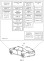
- FIG. 1 is a schematic functional block diagram of a vehicle 100 according to an embodiment of this application.
- the vehicle 100 may be configured to be in a full or partial automated driving mode.
- the vehicle 100 may obtain information about an ambient environment of the vehicle 100 by using a perception system 120, and obtain an automated driving strategy based on analysis of the information about the ambient environment, to implement full automated driving, or present an analysis result to a user, to implement partial automated driving.
- the vehicle 100 may include various subsystems, for example, an information and entertainment system 110, the perception system 120, a decision-making and control system 130, a drive system 140, and a computing platform 150.
- the vehicle 100 may include more or fewer subsystems, and each subsystem may include a plurality of components.
- each subsystem and component of the vehicle 100 may be connected to another in a wired or wireless manner.
- the information and entertainment system 110 may include a communication system 111, an entertainment system 112, and a navigation system 113.
- the communication system 111 may include a wireless communication system, and the wireless communication system may wirelessly communicate with one or more devices directly or by using a communication network.
- a wireless communication system 146 may perform communication by using a 3G cellular network, for example, CDMA, EVDO, or GSM/GPRS, or perform communication by using a 4G cellular network, for example, LTE, or perform communication by using a 5G cellular network.
- the wireless communication system may communicate with a wireless local area network (wireless local area network, WLAN) by using Wi-Fi.
- the wireless communication system 146 may directly communicate with a device by using an infrared link, Bluetooth, or ZigBee.
- the wireless communication system may include one or more dedicated short range communications (dedicated short range communications, DSRC) devices, and these devices may include public and/or private data communication between vehicles and/or roadside stations.
- DSRC dedicated short range communications
- the entertainment system 112 may include a central control screen, a microphone, and a sounder.
- a user may listen to radio and play music in a vehicle by using the entertainment system.
- a mobile phone is connected to a vehicle, to implement screen projection of the mobile phone on the central control screen.
- the central control screen may be a touchscreen, and the user may perform an operation by touching the screen.
- a voice signal of a user may be obtained by using the microphone, and some control performed by the user on the vehicle 100 is implemented based on analysis of the voice signal of the user, for example, a temperature inside the vehicle is adjusted.
- music may be played for the user by using the sounder.
- the navigation system 113 may include a map service provided by a map supplier, so as to provide navigation of a driving route for the vehicle 100.
- the navigation system 113 may be used together with a global positioning system 121 and an inertial measurement unit 122 of the vehicle.
- the map service provided by the map supplier may be a two-dimensional map or a high-definition map.
- the perception system 120 may include several types of sensors that sense the information about the ambient environment of the vehicle 100.
- the perception system 120 may include the global positioning system 121 (the global positioning system may be a GPS system, or may be a BeiDou system or another positioning system), the inertial measurement unit (inertial measurement unit, IMU) 122, a lidar 123, a millimeter-wave radar 124, an ultrasonic radar 125, and a camera apparatus 126.
- the perception system 120 may further include sensors (an in-vehicle air quality monitor, a fuel gauge, an oil temperature gauge, and the like) of an internal system of the monitored vehicle 100. Sensor data from one or more of these sensors may be used to detect an object and corresponding features (a position, a shape, a direction, a speed, and the like) of the object. Such detection and recognition are key functions of safe operation of the vehicle 100.
- the global positioning system 121 may be configured to estimate a geographical position of the vehicle 100.
- the inertial measurement unit 122 is configured to sense a position and an orientation change of the vehicle 100 based on inertial acceleration.
- the inertial measurement unit 122 may be a combination of an accelerometer and a gyroscope.
- the lidar 123 may sense, by using laser, an object in an environment in which the vehicle 100 is located.
- the lidar 123 may include one or more laser sources, a laser scanner and one or more detectors, and another system component.
- the millimeter-wave radar 124 may sense an object in the ambient environment of the vehicle 100 by using a radio signal.
- the radar 126 may further be configured to sense a speed and/or a moving direction of the object.
- the ultrasonic radar 125 may sense an object around the vehicle 100 by using an ultrasonic signal.
- the camera apparatus 126 may be configured to collect image information of the ambient environment of the vehicle 100.
- the camera apparatus 126 may include a monocular camera device, a binocular camera device, a structured light camera device, a panorama camera device, and the like.
- the image information obtained by the camera apparatus 126 may include a static image, or may include video stream information.
- the decision-making and control system 130 includes a computing system 131 that performs analysis and decision-making based on information obtained by the perception system 120.
- the decision-making and control system 130 further includes a vehicle controller 132 that controls a power system of the vehicle 100, and a steering system 133, a throttle 134 (including an acceleration pedal of an electric vehicle, which is an example name herein), and a braking system 135 that are configured to control the vehicle 100.
- the computing system 131 may be operated to process and analyze various information obtained by the perception system 120 to recognize a target, and an object and/or a feature in the ambient environment of the vehicle 100.
- the target may include a pedestrian or an animal, and the object and/or the feature may include a traffic signal, a road boundary, and an obstacle.
- the computing system 131 may use technologies such as an object recognition algorithm, a structure from motion (Structure from Motion, SFM) algorithm, and video tracking.
- the computing system 131 may be configured to: map an environment, track an object, estimate a speed of an object, and the like.
- the computing system 131 may analyze obtained various information and obtain a control strategy for the vehicle.
- the vehicle controller 132 may be configured to coordinate and control a power battery and an engine 141 of the vehicle, to improve power performance of the vehicle 100.
- the steering system 133 may be operated to adjust a traveling direction of the vehicle 100.
- the steering system 133 may be a steering wheel system.
- the throttle 134 is configured to control an operating speed of the engine 141 and further control a speed of the vehicle 100.
- the braking system 135 is configured to control the vehicle 100 to decelerate.
- the braking system 135 may slow down wheels 144 through friction force.
- the braking system 135 may convert kinetic energy of the wheels 144 into a current.
- the braking system 135 may alternatively reduce a rotation speed of the wheels 144 in another manner, to control the speed of the vehicle 100.
- the drive system 140 may include a component that provides power for the vehicle 100 to move.
- the drive system 140 may include the engine 141, an energy source 142, a transmission system 143, and the wheels 144.
- the engine 141 may be a combination of an internal combustion engine, a motor, an air compression engine, or another type of engine, for example, a hybrid engine including a gasoline engine and a motor, or a hybrid engine including an internal combustion engine and an air compression engine.
- the engine 141 converts the energy source 142 into mechanical energy.
- the energy source 142 includes, for example, gasoline, diesel, another oil-based fuel, propane, another compressed gas-based fuel, ethanol, a solar panel, a battery, and another power source.
- the energy source 142 may also provide energy for another system of the vehicle 100.
- the transmission apparatus 143 may transmit mechanical power from the engine 141 to the wheels 144.
- the transmission apparatus 143 may include a gearbox, a differential, and a drive shaft.
- the transmission apparatus 143 may further include another component, for example, a clutch.
- the drive shaft may include one or more shafts that may be coupled to one or more wheels 121.
- the computing platform 150 may include at least one processor 151, and the processor 151 may execute instructions 153 stored in a non-transitory computer-readable medium, for example, a memory 152.
- the computing platform 150 may alternatively be a plurality of computing devices that control an individual component or a subsystem of the vehicle 100 in a distributed manner.
- the processor 151 may be any conventional processor, for example, a commercially available CPU. Alternatively, the processor 151 may further include, for example, a graphics processing unit (Graphics Processing Unit, GPU), a field programmable gate array (Field Programmable Gate Array, FPGA), a system on chip (System on Chip, SOC), an application-specific integrated circuit (Application Specific Integrated Circuit, ASIC), or a combination thereof.
- FIG. 1 functionally illustrates the processor, the memory, and another element of a computer 110 in a same block, a person of ordinary skill in the art should understand that the processor, the computer, or the memory may actually include a plurality of processors, computers, or memories that may or may not be stored in a same physical housing.
- the memory may be a hard disk drive, or another storage medium located in a housing different from that of the computer 110. Therefore, a reference to the processor or the computer is understood as including a reference to a set of processors or computers or memories that may or may not operate in parallel. Different from using a single processor to perform the steps described herein, some components such as a steering component and a deceleration component may include respective processors. The processor performs only computation related to a component-specific function.
- the processor may be located far away from the vehicle and wirelessly communicate with the vehicle.
- some processes described herein are performed on a processor disposed inside the vehicle, while others are performed by a remote processor, including performing steps necessary for single manipulation.
- the memory 152 may include the instructions 153 (for example, program logic), and the instructions 153 may be executed by the processor 151 to perform various functions of the vehicle 100.
- the memory 152 may also include extra instructions, including instructions used to send data to, receive data from, interact with, and/or perform control on one or more of the information and entertainment system 110, the perception system 120, the decision-making and control system 130, and the drive system 140.
- the memory 152 may further store data, for example, a road map, route information, and a position, a direction, a speed, and other vehicle data of the vehicle, and other information. Such information may be used by the vehicle 100 and the computing platform 150 during operation of the vehicle 100 in an autonomous mode, a semi-autonomous mode, and/or a manual mode.
- the computing platform 150 may control functions of the vehicle 100 based on inputs received from various subsystems (for example, the drive system 140, the perception system 120, and the decision-making and control system 130). For example, the computing platform 150 may use an input from the decision-making and control system 130 to control the steering system 133 to avoid an obstacle detected by the perception system 120. In some embodiments, the computing platform 150 is operated to provide control on many aspects of the vehicle 100 and the subsystems of the vehicle.
- one or more of the foregoing components may be installed separately from or associated with the vehicle 100.
- the memory 152 may exist partially or completely separate from the vehicle 100.
- the foregoing components may be communicatively coupled together in a wired and/or wireless manner.
- FIG. 1 should not be construed as a limitation on embodiments of this application.
- An automated driving vehicle traveling on a road may recognize an object in an ambient environment of the automated driving vehicle, to determine to adjust a current speed.
- the object may be another vehicle, a traffic control device, or another type of object.
- each recognized object may be considered independently, and based on a feature of each object, for example, a current speed of the object, acceleration of the object, and a distance between the object and the vehicle, may be used to determine a speed to be adjusted by the automated driving vehicle.
- the vehicle 100 or a perception and computing device (for example, the computing system 131 and the computing platform 150) associated with the vehicle 100 may predict behavior of a recognized object based on a feature of the recognized object and a status of an ambient environment (traffic, rain, ice on a road, and the like).
- all recognized objects depend on behavior of each other, and therefore all recognized objects may be considered together to predict behavior of a single recognized object.
- the vehicle 100 can adjust the speed of the vehicle 100 based on the predicted behavior of the recognized object.
- the automated driving vehicle can determine, based on the predicted behavior of the object, a specific stable status (for example, acceleration, deceleration, or stop) to which the vehicle needs to be adjusted.
- another factor may also be considered for determining the speed of the vehicle 100, for example, a transverse position of the vehicle 100 on a road on which the vehicle travels, curvature of the road, and proximity between a static object and a dynamic object.
- the computing device may further provide an instruction for modifying a steering angle of the vehicle 100, so that the automated driving vehicle follows a given track and/or maintains safe transverse and longitudinal distances between the automated driving vehicle and an object (for example, a car in an adjacent lane on the road) near the automated driving vehicle.
- an object for example, a car in an adjacent lane on the road
- the vehicle 100 may be a car, a truck, a motorcycle, a bus, a boat, an airplane, a helicopter, a lawn mower, a recreational vehicle, a playground vehicle, a construction device, a trolley, a golf cart, a train, or the like. This is not specifically limited in embodiments of this application.
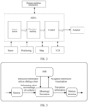
- FIG. 2 is a schematic diagram of an example framework of an intelligent driving system. From a perspective of logical functions, the intelligent driving system mainly includes a perception module, a decision-making module, and a control module.
- the intelligent driving system may be referred to as an automated driving system (automated driving system, ADS) or a driver assistance system, for example, an advanced driver assistance system (advanced driver assistant system, ADAS).
- ADS automated driving system
- ADAS advanced driver assistance system
- the intelligent driving system uses a sensor on a vehicle to obtain information about the vehicle and surroundings of the vehicle, and analyzes and processes the obtained information to implement obstacle perception, target recognition, vehicle positioning, route planning, driver monitoring/reminding, and the like, so as to improve driving safety, automation, and comfort of the vehicle.
- the perception module has an environmental perception capability, for example, may recognize an obstacle around the vehicle, detect a road mark, recognize a signal light, and detect behavior of a pedestrian/vehicle around the vehicle.
- more types and/or quantities of sensors for example, a lidar, a millimeter-wave radar, and a camera, are disposed on the vehicle.
- the perception module may further have a capability of sensing the vehicle itself, and there are more types of sensors that sense a status of the vehicle itself, including sensors configured to measure a speed, a temperature, pressure, a flow, a position, a gas concentration, light brightness, humidity, a distance, and the like.
- the perception module may obtain a speed of the vehicle by using a speed sensor, and obtain a position of an acceleration pedal or a braking pedal by using a position sensor.
- the perception module may determine a position of the vehicle relative to an environment by using a localization (localization) system.
- the localization system may be, for example, a global positioning system (global positioning system, GPS) and/or an inertial navigation system (inertial navigation system).
- the perception module obtains information about the vehicle and surroundings of the vehicle by using a sensor, and may process the obtained information and provide processed information to a planning module.
- the processing includes, for example, information fusion (information fusion) of a plurality of sensors, to improve accuracy of perception information.
- the perception module may be referred to as a sensor fusion module.
- the decision-making module may be referred to as a planning module, and performs driving decision-making/planning based on information provided by the perception module. For example, a decision on next driving behavior of the vehicle is made based on information about a current environment in which the vehicle is located, for example, acceleration/deceleration, lane switching, turning, braking, or warning.
- the intelligent driving system may further implement information exchange with a person (including a driver or a passenger) on the vehicle, obtain a requirement of the person on the vehicle, and feed back a current status or a warning of the vehicle to the person on the vehicle.
- the decision-making module may further perform route decision-making/planning, for example, select an optimal route based on a requirement of a user.
- the requirement of the user includes one or more of a start point, an end point, a waypoint, route preference, and the like.
- the control module performs corresponding control based on the driving decision of the decision-making module, for example, sends a control instruction to a corresponding executor or a controller of the executor, to control the executor to perform a corresponding action, for example, acceleration/deceleration, lane switching, turning, braking, or warning.
- An input of the intelligent driving system not only includes an information input of a sensor of the intelligent driving system, but also includes an information input obtained from another place, so as to improve automated driving performance.
- the intelligent driving system may obtain map information from a server of a map supplier to assist in driving decision-making.
- the intelligent driving system may obtain driving environment information, for example, weather information and traffic status information (a vehicle flow, an average vehicle flow speed, and the like), from a cloud to assist in driving decision-making.
- the intelligent driving system may obtain driving information and/or perception information of another vehicle from another intelligent terminal (another intelligent vehicle, a portable terminal of a pedestrian, or the like) to assist in driving decision-making.
- the intelligent driving system may obtain information from another place by using a wireless communication technology.
- the wireless communication technology is, for example, cellular network-based communication or dedicated short range communications (dedicated short range communications, DSRC).
- the cellular network-based communication is, for example, a long term evolution (long term evolution, LTE) communication technology or a 5th generation (5th generation, 5G) communication technology.
- the cellular network-based communication includes vehicle-to-everything (vehicle-to-everything, V2X) communication
- V2X communication includes vehicle-to-vehicle (vehicle to vehicle, V2V) communication, vehicle-to-infrastructure (vehicle to infrastructure, V2I) communication, vehicle-to-pedestrian (vehicle to pedestrian, V2P) communication, vehicle-to-network (vehicle to network, V2N) communication, or the like.
- V2X vehicle-to-everything
- V2X communication includes vehicle-to-vehicle (vehicle to vehicle, V2V) communication, vehicle-to-infrastructure (vehicle to infrastructure, V2I) communication, vehicle-to-pedestrian (vehicle to pedestrian, V2P) communication, vehicle-to-network (vehicle to network, V2N) communication, or the like.
- implementation of the intelligent driving system requires relatively large computing power, and is usually implemented by using a dedicated hardware platform, for example, a multi-domain controller (Multi Domain Controller, MDC).
- MDC Multi Domain Controller
- all or some functions of the perception module, the decision-making module, and the control module are implemented by using the dedicated hardware platform, for example, the MDC.
- Software in the intelligent driving system may be upgraded.
- an information processing algorithm of the perception module, a decision-making algorithm of the decision-making module, or the like may be upgraded in a software update manner.
- the software update may be implemented by using an over-the-air (over the air, OTA) technology.
- OTA over-the-air
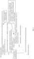
- FIG. 3 is a schematic diagram of functional modules of an intelligent driving system according to an embodiment of this application.
- information about surroundings of a vehicle obtained by a perception module of the vehicle is transmitted to a roaming (navigation) module in an intelligent driving system of the vehicle.
- an operation instruction for example, instruction information such as shifting a lever
- the roaming (navigation) module in the intelligent driving system of the vehicle.
- the (roaming) navigation module makes a decision on whether to plan a route, switch a lane, or switch a navigation route.
- Information about decision-making completion is transmitted to a motion planning module of the vehicle for transverse and/or longitudinal motion planning of the vehicle, and the information about decision-making completion is also transmitted to the HMI, so as to implement visualization of a motion situation of the vehicle.
- the intelligent driving system may further include but is not limited to, for example, an apparatus like a processor and a memory.
- an intelligent vehicle may implement a roaming (Roam) mode that is based on a high-definition map.
- Roam roaming
- the vehicle can implement precise navigation from a start point to an end point by using the high-definition map.
- a driver of the vehicle performs a related control operation on the vehicle in a navigation process, for example, lane switching, intersection passing, or partial navigation strategy changing.
- the vehicle does not exit the navigation process, but partially adjusts the navigation process in real time based on the operation of the driver.
- the "overall navigation strategy" means a navigation purpose of the vehicle from the start point to the end point.
- the "partial navigation strategy" means adjustment on lane choices and turn choices of partial road sections in a process of the vehicle traveling from the start point to the end point.
- the roaming mode may further mean that the vehicle travels based on the high-definition map when no navigation target is set for the vehicle.
- the vehicle recognizes an ambient environment based on the high-definition map (or based on information obtained by a sensor of the vehicle), and travels on a road based on recognized information.
- the driver may perform a related control operation on the vehicle, for example, lane switching, intersection passing, or driving direction changing of the vehicle (for example, the vehicle changes from going straight through to turning right).
- the intelligent vehicle can implement precise lane-level navigation from the start point to the end point by using the high-definition map.
- the vehicle driver can dynamically optimize and adjust a partial navigation route of the vehicle based on a current situation in a vehicle driving process, and does not interrupt a previous setting of an overall navigation direction that is based on the high-definition map, so that advantages of a machine and a human are combined, and the intelligent vehicle is more intelligent.
- highest control rights are granted to the human driver, so that the intelligent vehicle is more user-friendly.
- intelligent vehicle generally is a vehicle whose SAE level is level 2 or higher.
- FIG. 4 is a schematic diagram of a functional framework of a roaming navigation system according to an embodiment of this application.
- the roaming navigation system includes two procedures: a planning procedure and a navigation procedure.
- Functions of the planning procedure include planning a driving strategy of a vehicle, and transmitting planned navigation information to the navigation procedure.
- the navigation procedure determines the driving strategy of the vehicle based on specified navigation information and the planned navigation information that is obtained from the planning procedure and/or an operation of a driver, and guides, based on the driving strategy of the vehicle, the vehicle to roam.
- a planning process is repeatedly iterated, so that the vehicle continuously updates an optimized driving strategy of a next section of a route, so as to implement "roaming". It should be noted that the foregoing planning procedure and the navigation procedure are still implemented by the vehicle on the premise that a high-definition map is introduced.
- the planning procedure is specifically described below.
- the vehicle is in a roaming mode, that is, the vehicle is, for example, in a driving state determined by the roaming navigation system shown in FIG. 4 .
- a trigger condition of iterative forward search includes at least one of the following: there is no planned route ahead of the vehicle, the vehicle has passed through a road intersection, a distance between the vehicle and a maximum range of current forward search is less than a specified threshold, or the vehicle yaws.
- the vehicle may have a specific event to trigger forward search during driving, so as to implement a continuous iterative forward search process. Specifically, a position of the ego vehicle is used as a start point, and forward multi-directional search is performed based on related information of the high-definition map.
- a maximum range Smax of forward search may be preset, for example, 3000 meters to 5000 meters.
- Information about a road in the maximum range of the forward search may be obtained by using information of the high-definition map. It should be understood that the maximum range Smax of the forward search is a parameter that may be adjusted based on an area in which the vehicle travels. On a highway section, the maximum range Smax may be set to, for example, 3000 meters to 6000 meters, and on an urban road section, the maximum range Smax may be set to, for example, 500 meters to 1500 meters.
- the planning procedure learns that a structure of a road ahead in the range Smax is without fork. In this case, it means that a road ahead of the vehicle is a through road without fork, and the vehicle keeps going straight through.
- traversal search is performed on all branches (for example, m branches) of the road fork.
- the traversal search includes: continuing to search forward along any one of the branches in the maximum range of the forward search; and if another road fork (for example, which may be referred to as a second road fork) is encountered, for the second road fork, searching for a road branch (fork) with lowest turn cost of the second road fork, and setting the road branch with the lowest turn cost as a default navigation route of the second road fork.
- the turn cost may be determined by at least one of turn behavior cost and turn angle cost, or may be determined by both turn behavior cost and turn angle cost.
- the roaming navigation system provides roaming navigation that is based on a driving habit, which may be activated by a driver through voluntary authorization. After this function is activated through authorization, the roaming navigation system records a choice of the vehicle when the vehicle has passed through each road fork (intersection or ramp), so as to provide a historical data reference for a choice of a subsequent default navigation route.
- a parameter of "driver habit cost” is added, that is, turn cost is obtained by using "turn behavior cost", "turn angle cost", and "driver habit cost” as parameters.
- the driver habit cost may be qualitatively defined as follows: A higher frequency of historical occurrence of a habit indicates higher cost of violating the habit. For example, if historical data of a driver at an intersection shows that the driver always turns right at the intersection, and if another strategy (for example, left turn) is performed instead of turning right at the intersection, driver habit cost at the intersection is high. Further, if there is only one type of historical turn behavior at a road fork (for example, the driver always turns right at the intersection as mentioned in the foregoing example), or a frequency of a specific type of turn behavior is definitely higher than that of other behavior in a history, impact of driver habit cost of the road fork is definitely greater than the other two types of cost.
- the roaming navigation system may determine turn cost of the road fork only based on the driver habit cost. In short, in this case, the roaming navigation system determines a current driving route choice for the road fork based on a choice for the road fork of the driver in a history, without considering turn behavior cost and turn angle cost. In this case, a default navigation route of the vehicle at the road fork is determined based on the driver habit cost.
- the roaming navigation system For a road fork, if there are a plurality of historical turn choices with little difference in frequency, or there is no historical choice, the roaming navigation system considers turn behavior cost and turn angle cost, that is, determines turn cost (default navigation route) based on the foregoing three parameters ("turn behavior cost”, "turn angle cost”, and "driver habit cost”).
- a search distance from the ego vehicle to the foregoing second road fork exceeds a minimum search distance Smin. If the search distance from the vehicle to the foregoing second road fork exceeds the minimum search distance Smin, the search is stopped.
- Smin may be set to, for example, any value within 500 meters to 1500 meters. A reason for such setting is as follows: A computing amount of traversal search for a road fork increases exponentially as a quantity of road forks increases.
- the vehicle may learn of a structure of a road ahead, and preliminarily determine a default navigation route for the vehicle at a road intersection ahead of the vehicle.
- FIG. 5 shows pseudocode of a planning procedure of a roaming mode according to an embodiment of this application.
- the navigation procedure is specifically described below.
- the structure of the road ahead obtained in the foregoing planning procedure is transmitted to the navigation procedure in real time.
- the navigation procedure first checks in real time whether there is available navigation information, and if there is available navigation information, obtains default turn behavior with lowest turn cost for a current lane, and determines, based on the default turn behavior, a default navigation route at a first road fork ahead in a driving direction of the vehicle.
- a method for determining turn cost of the current lane may be consistent with logic for determining turn cost in the foregoing planning procedure. Generally, turn cost of the vehicle passing straight through a road fork is the smallest.
- a turn type of the vehicle is set to a default turn type for a switched-to lane.
- the navigation procedure continues to determine whether the vehicle is in an intelligent driving state. If the vehicle is in an intelligent driving state, it indicates that the vehicle is currently in an intelligent driving state supported by the high-definition map. In this case, a behavior output of the driver is obtained, that is, if the driver has a lane switching request or a navigation route switching request in the intelligent driving state, a lane switching decision or a navigation route switching decision is made with reference to information about an ambient environment of the vehicle.
- the navigation procedure determines a specific position of the current lane. If the current lane is not a rightmost lane of a road, and a turn type of the vehicle is the default navigation route, a lane switching operation (intention) of the driver is approved, and the vehicle performs lane switching. If either of the foregoing two conditions is not met, the lane switching operation (intention) of the driver is not approved, and the navigation procedure makes the navigation route switching decision.
- the second lane on the left is a through lane
- a leftmost lane (that is, a first lane on the left) of the road is a left-turn lane
- the driver shifts the lever leftward to intend to switch a lane leftward based on the foregoing determining logic, when the vehicle is not in the first lane on the left, and a current turn type of the vehicle is straight-through driving (that is, a default turn type for the second lane on the left)
- the vehicle may switch a lane, and after lane switching, a turn type of the vehicle is set to a default turn type for the first lane on the left, that is, left turn.
- a distance between the vehicle and the road fork is greater than a safe distance. If the distance between the vehicle and the road fork is not greater than the safe distance, it is considered that the vehicle is excessively close to the road fork, and operations such as lane switching are not suitable for safety. If the distance between the vehicle and the road fork is greater than the safe distance, it is considered that the vehicle is far enough away from the road fork, and operations such as lane switching may be performed on the premise of safety.
- the safe distance may be preset, for example, any value within 30 meters to 50 meters, or may be determined based on a distance required for the vehicle to brake at a current speed to stop.
- a turn type of the vehicle is set to a next rightward turn type (that is, a next rightward road branch of a road intersection ahead of the vehicle compared with a current default navigation route of the vehicle).
- the "next rightward turn type” means a next rightward branch route that is of a road intersection closest to the vehicle and that has a second smallest included angle compared with the current default navigation route of the vehicle. More specifically, the included angle means an included angle between the rightward branch route and a line segment that is determined by a current position of the vehicle and a position of the road intersection.
- a next rightward turn type of the vehicle means a right-turn route of the intersection for the vehicle.
- a road intersection ahead of the vehicle is (for example, but not limited to) a road intersection with six radial routes, with reference to a scenario schematic diagram shown in FIG. 6-1 , when the vehicle turns right at a road intersection H, there are two possible choices: a right-turn branch 1 and a right-turn branch 2.
- a "next rightward turn type" of the vehicle means a right-turn branch route having a relatively large included angle with a current driving lane of the vehicle, that is, the right-turn branch 1. If a current default navigation route of the vehicle V is the right-turn branch 1, and under this premise, the driver performs an operation (intention), for example, shifts the lever rightward, a turn type of the vehicle is changed to "turn at the intersection ahead into a right-turn branch route having a relatively small included angle with a current driving lane", that is, the turn type of the vehicle is changed to the "right-turn branch 2".
- a turn type of the vehicle is opposite to a direction of lever shifting behavior of the driver at this time.
- the navigation procedure restores the turn type of the vehicle to a default navigation route at the beginning of roaming mode logic.
- the example in a previous paragraph is used for continuous description. If the turn type of the vehicle is changed to the right-turn branch 2 of the road intersection after the driver shifts the lever rightward, and in this case, the driver shifts the lever leftward, the turn type of the vehicle is changed to a default turn type (that is, straight-through driving) at the beginning of the procedure.
- the right-turn branch of the road intersection is used as an example in the foregoing description, based on left-right symmetry, the foregoing logic is still true after "right” in the foregoing description is replaced with "left".
- FIG. 6-2 shows pseudocode of a navigation procedure of a roaming mode according to an embodiment of this application.
- the roaming mode is described below with reference to a specific road scenario.
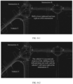
- FIG. 7-1 is a schematic diagram of a vehicle V in a roaming navigation state based on a high-definition map at a moment in a road scenario. It may be learned from FIG. 7-1 that, the vehicle V is in a through or right-turn lane, and there is an intersection A and an intersection B in sequence ahead of the vehicle V (a right part of the vehicle V in FIG. 7-1 ).
- the intersection A has four road forks, which means that the intersection A is a crossroad from a topological perspective.
- the vehicle V passes straight through the intersection A and the intersection B by default. In other words, a default navigation route of the vehicle V at the intersection A and the intersection B ahead is to "pass straight through" the intersection A and the intersection B.
- FIG. 7-2 is a schematic diagram of the vehicle V in the roaming navigation state based on the high-definition map at a subsequent moment in the scenario shown in FIG. 7-1 .
- the vehicle V passed straight through the intersection A.
- This condition triggers iterative planning of a roaming navigation system (refer to one of the conditions of iterative planning in the pseudocode in FIG. 5 : "passed through a first road-level fork"), and the system re-plans a plurality of driving routes.
- the vehicle V is in a through or right-turn lane, and there is the intersection B and an intersection C in sequence ahead of the vehicle V (a right part of the vehicle V in FIG. 7-2 ).
- intersection B has four road forks, which means that the intersection B is a crossroad from a topological perspective. Therefore, the navigation roaming system plans four possible driving routes at the intersection B, which correspond to the four forks of the crossroad.
- a default navigation route of the vehicle is to pass straight through the intersection B.
- a default navigation route of the vehicle is to pass straight through the intersection C.
- a thread of the navigation system of the vehicle ensures that the vehicle continues to travel according to a navigation route, and does not exit an automated driving process.
- FIG. 8-1 is a schematic diagram of a vehicle V in a roaming navigation state based on a high-definition map at a moment in a road scenario. It may be learned from FIG. 8-1 that, the vehicle V is in a through or right-turn lane, and there is an intersection A and an intersection B in sequence ahead of the vehicle V (a right part of the vehicle V in FIG. 8-1 ).
- the intersection A has four road forks, which means that the intersection A is a crossroad from a topological perspective. After planning is completed, the vehicle V passes straight through the intersection A by default.
- the vehicle V At a current moment, the vehicle V is 20 meters away from a fork where a right-turn lane diverges from a main road, and a speed of the vehicle V is 6.0 m/S. If a deceleration of the vehicle is -1 m/S 2 , a distance required for the vehicle V to brake to stop is 18 meters, and the braking distance is less than a distance (20 meters) between the vehicle V and the fork where the right-turn lane diverges from the main road.
- a current default navigation route of the vehicle is set to a next rightward turn type, that is, the vehicle turns right at the next crossroad A.
- FIG. 8-2 is a schematic diagram of the vehicle V in the roaming navigation state based on the high-definition map at a subsequent moment in the scenario shown in FIG. 8-1 .
- the vehicle V keeps a roaming mode and travels forward for 5 meters at a speed of 6.0 m/S.
- the vehicle V is 15 meters away from the fork where the right-turn lane diverges from the main road, and a safe distance for the vehicle to brake to stop is still 18 meters.
- the vehicle V still turns right at the intersection A, because a distance between the vehicle V and the fork of the intersection A is less than the safe distance, and the determining logic in the foregoing navigation procedure is not met.
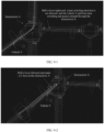
- FIG. 9-1 is a schematic diagram of a vehicle V in a roaming navigation state based on a high-definition map at a moment in a road scenario. It may be learned from FIG. 9-1 that, the vehicle V is in a left-turn lane, and there is an intersection A and an intersection B in sequence ahead of the vehicle V (a right part of the vehicle V in FIG. 9-1 ).
- the intersection A has four road forks, which means that the intersection A is a crossroad from a topological perspective.
- a default navigation route of the vehicle V is to turn left at the first intersection A.
- the vehicle V If the driver shifts a steering lever rightward (that is, the driver intends to turn right), based on the determining logic in the foregoing navigation procedure, the vehicle V first switches a lane from the left-turn lane to a through lane, and then passes straight through the intersection A.
- FIG. 9-2 is a schematic diagram of a vehicle V in a roaming navigation state based on a high-definition map at a moment in a road scenario.
- the vehicle V is in a left-turn lane, and there is an intersection A and an intersection B in sequence ahead of the vehicle V (a right part of the vehicle V in FIG. 9-1 ).
- the intersection A has four road forks, which means that the intersection A is a crossroad from a topological perspective.
- a current speed of the vehicle V is 7.0 m/S. If a deceleration of the vehicle is -1 m/S 2 , a distance required for the vehicle V to brake to stop is 24.5 meters.
- the braking distance of the vehicle V is less than a distance between the vehicle and the road intersection.
- a default navigation route of the vehicle is changed to a next leftward turn type, that is, a turn type that is more "leftward” than a current turn type (left turn).
- the vehicle V switches to a turn type of "U-turn", and the vehicle V makes a U-shaped turn at the intersection V
- the roaming navigation system of the vehicle recognizes such a situation, notifies, in a human-machine interaction manner, the vehicle driver that a roaming function of the vehicle is currently restricted, and requests the driver to perform take-over.
- the vehicle takes a measure, for example, function degradation or parking based on a specific surrounding situation.
- the function degradation may mean, for example, degrading a roaming function that is based on the high-definition map to a vehicle cruise function that is based on road structure cognition.
- lever shifting of the driver is used as an example of an operation in which the driver expresses an intention of the driver, other operations may also be used, provided that the operation expresses an intention of the driver, for example, a button operation, voice input, and gesture recognition.
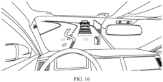
- FIG. 10 shows that a vehicle displays, by using a head-up display (HUD), information to a driver that the vehicle is about to switch a lane leftward according to an embodiment of this application.
- HUD head-up display
- other types of information for example, U-turn, turn, position, and speed information of the vehicle, may also be displayed to the driver in a plurality of manners, for example, displayed by using a central control screen, or broadcast by using a voice.
- the described apparatus embodiment is merely an example.
- the units described as separate components may or may not be physically separate, and components displayed as units may or may not be physical units, may be located in one position, or may be distributed on a plurality of network units. Some or all of the modules may be selected according to an actual need to achieve objectives of the solutions of embodiments.
- connection relationships between modules indicate that the modules are communicatively connected to each other, which may be specifically implemented as one or more communication buses or signal cables.
- this application may be implemented by software in addition to necessary universal hardware, or by dedicated hardware, including a dedicated integrated circuit, a dedicated CPU, a dedicated memory, a dedicated component, and the like.
- any function implemented by a computer program may be easily implemented by using corresponding hardware.
- specific hardware structures used to implement a same function may be various, for example, an analog circuit, a digital circuit, or a dedicated circuit.
- a software program implementation is a better implementation in most cases. Based on such an understanding, the technical solutions of this application essentially or the part contributing to the conventional technology may be implemented in a form of software product.
- the computer software product is stored in a readable storage medium, for example, a floppy disk, a USB flash drive, a removable hard disk, a ROM, a RAM, a magnetic disk, or an optical disc of a computer, and includes several instructions for instructing a computer device (which may be a personal computer, a server, or a network device) to perform the methods described in embodiments of this application.
- a computer device which may be a personal computer, a server, or a network device
- All or some of the foregoing embodiments may be implemented by software, hardware, firmware, or any combination thereof.
- software is used to implement the foregoing embodiments, all or some of the foregoing embodiments may be implemented in a form of computer program product.
- the computer program product includes one or more computer instructions.
- the computer may be a general-purpose computer, a dedicated computer, a computer network, or another programmable apparatus.
- the computer instructions may be stored in a computer-readable storage medium or may be transmitted from a computer-readable storage medium to another computer-readable storage medium.
- the computer instructions may be transmitted from a website, computer, server, or data center to another website, computer, server, or data center in a wired (for example, a coaxial cable, an optical fiber, or a digital subscriber line (DSL)) or wireless (for example, infrared, radio, or microwave) manner.
- a wired for example, a coaxial cable, an optical fiber, or a digital subscriber line (DSL)
- wireless for example, infrared, radio, or microwave
- the computer-readable storage medium may be any usable medium accessible to a computer, or a data storage device integrating one or more usable media, for example, a server or a data center.
- the usable medium may be a magnetic medium (for example, a floppy disk, a hard disk, or a magnetic tape), an optical medium (for example, a DVD), a semiconductor medium (for example, a solid-state drive (Solid State Drive, SSD)), or the like.
Landscapes
- Engineering & Computer Science (AREA)
- Radar, Positioning & Navigation (AREA)
- Remote Sensing (AREA)
- Automation & Control Theory (AREA)
- Physics & Mathematics (AREA)
- Mechanical Engineering (AREA)
- Transportation (AREA)
- General Physics & Mathematics (AREA)
- Social Psychology (AREA)
- General Health & Medical Sciences (AREA)
- Health & Medical Sciences (AREA)
- Human Computer Interaction (AREA)
- Mathematical Physics (AREA)
- Control Of Driving Devices And Active Controlling Of Vehicle (AREA)
- Navigation (AREA)
- Traffic Control Systems (AREA)
Applications Claiming Priority (1)
| Application Number | Priority Date | Filing Date | Title |
|---|---|---|---|
| PCT/CN2021/138179 WO2023108455A1 (zh) | 2021-12-15 | 2021-12-15 | 一种智能驾驶方法、装置及包括该装置的车辆 |
Publications (3)
| Publication Number | Publication Date |
|---|---|
| EP4428645A1 true EP4428645A1 (de) | 2024-09-11 |
| EP4428645A4 EP4428645A4 (de) | 2025-02-26 |
| EP4428645B1 EP4428645B1 (de) | 2026-03-18 |
Family
ID=86775003
Family Applications (1)
| Application Number | Title | Priority Date | Filing Date |
|---|---|---|---|
| EP21967595.6A Active EP4428645B1 (de) | 2021-12-15 | 2021-12-15 | Intelligentes antriebsverfahren und vorrichtung sowie fahrzeug mit der vorrichtung |
Country Status (4)
| Country | Link |
|---|---|
| US (1) | US20240337499A1 (de) |
| EP (1) | EP4428645B1 (de) |
| CN (1) | CN118805151A (de) |
| WO (1) | WO2023108455A1 (de) |
Families Citing this family (4)
| Publication number | Priority date | Publication date | Assignee | Title |
|---|---|---|---|---|
| SE2450132A1 (en) * | 2024-02-12 | 2025-08-13 | Scania Cv Ab | Control arrangement and method for controlling a powertrain of a vehicle |
| CN119443458B (zh) * | 2025-01-07 | 2025-03-21 | 浙江吉利控股集团有限公司 | 轨迹生成方法、装置、电子设备、存储介质及程序产品 |
| CN120003484B (zh) * | 2025-03-21 | 2025-12-02 | 东风悦享科技有限公司 | 一种基于导航的自适应辅助驾驶系统及方法 |
| CN120877548A (zh) * | 2025-09-28 | 2025-10-31 | 广州小鹏自动驾驶科技有限公司 | 移动装置的控制方法、车机系统和车辆 |
Family Cites Families (10)
| Publication number | Priority date | Publication date | Assignee | Title |
|---|---|---|---|---|
| JP5796481B2 (ja) * | 2011-12-21 | 2015-10-21 | トヨタ自動車株式会社 | 軌跡制御装置および軌跡制御方法 |
| JP6332170B2 (ja) * | 2015-07-01 | 2018-05-30 | トヨタ自動車株式会社 | 自動運転制御装置 |
| JP6293197B2 (ja) * | 2016-04-26 | 2018-03-14 | 本田技研工業株式会社 | 車両制御システム、車両制御方法、および車両制御プログラム |
| KR102395283B1 (ko) * | 2016-12-14 | 2022-05-09 | 현대자동차주식회사 | 자율 주행 제어 장치, 그를 포함한 시스템 및 그 방법 |
| WO2020226014A1 (ja) * | 2019-05-07 | 2020-11-12 | ソニーセミコンダクタソリューションズ株式会社 | 情報処理装置、移動装置、および方法、並びにプログラム |
| CN113767025B (zh) * | 2019-05-15 | 2024-12-31 | 日产自动车株式会社 | 显示控制方法及显示控制装置 |
| WO2020257366A1 (en) * | 2019-06-17 | 2020-12-24 | DeepMap Inc. | Updating high definition maps based on lane closure and lane opening |
| DE102020216470A1 (de) * | 2019-12-26 | 2021-07-01 | Mando Corporation | Fahrerassistenzsystem, damit ausgestattetes fahrzeug und verfahren zum steuern des fahrzeugs |
| US11433897B2 (en) * | 2020-03-13 | 2022-09-06 | GM Global Technology Operations LLC | Method and apparatus for determination of optimal cruising lane in an assisted driving system |
| JP7495179B2 (ja) * | 2020-05-01 | 2024-06-04 | 株式会社Subaru | 運転支援装置 |
-
2021
- 2021-12-15 EP EP21967595.6A patent/EP4428645B1/de active Active
- 2021-12-15 CN CN202180105439.9A patent/CN118805151A/zh active Pending
- 2021-12-15 WO PCT/CN2021/138179 patent/WO2023108455A1/zh not_active Ceased
-
2024
- 2024-06-14 US US18/744,100 patent/US20240337499A1/en active Pending
Also Published As
| Publication number | Publication date |
|---|---|
| CN118805151A (zh) | 2024-10-18 |
| EP4428645B1 (de) | 2026-03-18 |
| WO2023108455A1 (zh) | 2023-06-22 |
| US20240337499A1 (en) | 2024-10-10 |
| EP4428645A4 (de) | 2025-02-26 |
Similar Documents
| Publication | Publication Date | Title |
|---|---|---|
| EP4428645B1 (de) | Intelligentes antriebsverfahren und vorrichtung sowie fahrzeug mit der vorrichtung | |
| EP4067821A1 (de) | Wegplanungsverfahren für ein fahrzeug und wegplanungsvorrichtung für ein fahrzeug | |
| CN113511141B (zh) | 用于车辆中的增强现实的系统和方法 | |
| US9994221B2 (en) | Presenting travel settings for selection of nearby vehicle to follow | |
| EP4045992B1 (de) | Verfahren zum parken eines autonomen fahrzeugs zum autonomen laden | |
| US20180272934A1 (en) | Information presentation system | |
| US20230194286A1 (en) | Systems, Methods, and Apparatus for using Remote Assistance to Navigate in an Environment | |
| US20180319402A1 (en) | System and method for automatic activation of driver assistance feature | |
| CN108806295A (zh) | 自动车辆路线穿越 | |
| CN104470781A (zh) | 基于替代数据推断交通信号状态和车辆环境的其他方面 | |
| CN114935334B (zh) | 车道拓扑关系的构建方法、装置、车辆、介质及芯片 | |
| US20240345584A1 (en) | Systems and methods for updating navigational maps | |
| US20200310448A1 (en) | Behavioral path-planning for a vehicle | |
| CN115042821B (zh) | 车辆控制方法、装置、车辆及存储介质 | |
| US20240174217A1 (en) | Method and apparatus for determining pull-out direction | |
| JP6460420B2 (ja) | 情報表示装置、情報表示方法、および情報表示プログラム | |
| CN114802217A (zh) | 确定泊车模式的方法、装置、存储介质及车辆 | |
| US12488592B2 (en) | Systems, methods, and apparatus for using remote assistance to classify objects in an environment | |
| CN112824150A (zh) | 通信预期交通工具操纵的系统和方法 | |
| US20240321110A1 (en) | Methods and Computing Systems for Vehicle to Vehicle Platooning and Communications | |
| US20230192124A1 (en) | Methods and Systems for Providing Remote Assistance to an Autonomous Vehicle | |
| CN114537450A (zh) | 车辆控制方法、装置、介质、芯片、电子设备及车辆 | |
| CN115447601A (zh) | 车辆控制方法及相关装置 | |
| US12448002B2 (en) | Vehicle traveling control method, electronic device, storage medium, chip and vehicle | |
| CN117774944A (zh) | 自动泊车的方法、装置、设备、车辆及可读存储介质 |
Legal Events
| Date | Code | Title | Description |
|---|---|---|---|
| STAA | Information on the status of an ep patent application or granted ep patent |
Free format text: STATUS: THE INTERNATIONAL PUBLICATION HAS BEEN MADE |
|
| PUAI | Public reference made under article 153(3) epc to a published international application that has entered the european phase |
Free format text: ORIGINAL CODE: 0009012 |
|
| STAA | Information on the status of an ep patent application or granted ep patent |
Free format text: STATUS: REQUEST FOR EXAMINATION WAS MADE |
|
| 17P | Request for examination filed |
Effective date: 20240606 |
|
| AK | Designated contracting states |
Kind code of ref document: A1 Designated state(s): AL AT BE BG CH CY CZ DE DK EE ES FI FR GB GR HR HU IE IS IT LI LT LU LV MC MK MT NL NO PL PT RO RS SE SI SK SM TR |
|
| RAP1 | Party data changed (applicant data changed or rights of an application transferred) |
Owner name: SHENZHEN YINWANG INTELLIGENTTECHNOLOGIES CO., LTD. |
|
| REG | Reference to a national code |
Ref country code: DE Free format text: PREVIOUS MAIN CLASS: G05D0001020000 Ref country code: DE Ref legal event code: R079 Ref document number: 602021050446 Country of ref document: DE Free format text: PREVIOUS MAIN CLASS: G05D0001020000 Ipc: B60W0060000000 |
|
| A4 | Supplementary search report drawn up and despatched |
Effective date: 20250124 |
|
| RIC1 | Information provided on ipc code assigned before grant |
Ipc: G01C 21/36 20060101ALI20250120BHEP Ipc: G01C 21/34 20060101ALI20250120BHEP Ipc: G01C 21/26 20060101ALI20250120BHEP Ipc: B60W 50/00 20060101ALI20250120BHEP Ipc: B60W 50/10 20120101ALI20250120BHEP Ipc: B60W 40/09 20120101ALI20250120BHEP Ipc: B60W 30/18 20120101ALI20250120BHEP Ipc: B60W 60/00 20200101AFI20250120BHEP |
|
| DAV | Request for validation of the european patent (deleted) | ||
| DAX | Request for extension of the european patent (deleted) | ||
| GRAP | Despatch of communication of intention to grant a patent |
Free format text: ORIGINAL CODE: EPIDOSNIGR1 |
|
| STAA | Information on the status of an ep patent application or granted ep patent |
Free format text: STATUS: GRANT OF PATENT IS INTENDED |
|
| RIC1 | Information provided on ipc code assigned before grant |
Ipc: B60W 60/00 20200101AFI20251006BHEP Ipc: B60W 30/18 20120101ALI20251006BHEP Ipc: B60W 40/09 20120101ALI20251006BHEP Ipc: B60W 50/10 20120101ALI20251006BHEP Ipc: B60W 50/00 20060101ALI20251006BHEP Ipc: G01C 21/26 20060101ALI20251006BHEP Ipc: G01C 21/34 20060101ALI20251006BHEP Ipc: G01C 21/36 20060101ALI20251006BHEP |
|
| INTG | Intention to grant announced |
Effective date: 20251015 |
|
| GRAS | Grant fee paid |
Free format text: ORIGINAL CODE: EPIDOSNIGR3 |
|
| GRAA | (expected) grant |
Free format text: ORIGINAL CODE: 0009210 |
|
| STAA | Information on the status of an ep patent application or granted ep patent |
Free format text: STATUS: THE PATENT HAS BEEN GRANTED |
|
| AK | Designated contracting states |
Kind code of ref document: B1 Designated state(s): AL AT BE BG CH CY CZ DE DK EE ES FI FR GB GR HR HU IE IS IT LI LT LU LV MC MK MT NL NO PL PT RO RS SE SI SK SM TR |
|
| REG | Reference to a national code |
Ref country code: CH Ref legal event code: F10 Free format text: ST27 STATUS EVENT CODE: U-0-0-F10-F00 (AS PROVIDED BY THE NATIONAL OFFICE) Effective date: 20260318 Ref country code: GB Ref legal event code: FG4D |