EP4155772A1 - Système et procédé de sélection et d'affichage d'image radar vertical à tranche azimutale priorisée - Google Patents
Système et procédé de sélection et d'affichage d'image radar vertical à tranche azimutale priorisée Download PDFInfo
- Publication number
- EP4155772A1 EP4155772A1 EP22197545.1A EP22197545A EP4155772A1 EP 4155772 A1 EP4155772 A1 EP 4155772A1 EP 22197545 A EP22197545 A EP 22197545A EP 4155772 A1 EP4155772 A1 EP 4155772A1
- Authority
- EP
- European Patent Office
- Prior art keywords
- cell
- aircraft
- processor
- highest priority
- display
- Prior art date
- Legal status (The legal status is an assumption and is not a legal conclusion. Google has not performed a legal analysis and makes no representation as to the accuracy of the status listed.)
- Pending
Links
- 238000000034 method Methods 0.000 title claims description 17
- 238000002310 reflectometry Methods 0.000 claims abstract description 60
- 230000010261 cell growth Effects 0.000 claims abstract description 14
- 230000012010 growth Effects 0.000 claims description 9
- 238000012545 processing Methods 0.000 description 9
- 231100001261 hazardous Toxicity 0.000 description 3
- 238000005259 measurement Methods 0.000 description 3
- 230000008901 benefit Effects 0.000 description 2
- 238000013459 approach Methods 0.000 description 1
- 238000004883 computer application Methods 0.000 description 1
- 238000010276 construction Methods 0.000 description 1
- 238000013461 design Methods 0.000 description 1
- 238000010586 diagram Methods 0.000 description 1
- 230000006870 function Effects 0.000 description 1
- 230000003287 optical effect Effects 0.000 description 1
Images


Classifications
-
- G—PHYSICS
- G01—MEASURING; TESTING
- G01S—RADIO DIRECTION-FINDING; RADIO NAVIGATION; DETERMINING DISTANCE OR VELOCITY BY USE OF RADIO WAVES; LOCATING OR PRESENCE-DETECTING BY USE OF THE REFLECTION OR RERADIATION OF RADIO WAVES; ANALOGOUS ARRANGEMENTS USING OTHER WAVES
- G01S7/00—Details of systems according to groups G01S13/00, G01S15/00, G01S17/00
- G01S7/02—Details of systems according to groups G01S13/00, G01S15/00, G01S17/00 of systems according to group G01S13/00
- G01S7/04—Display arrangements
- G01S7/06—Cathode-ray tube displays or other two dimensional or three-dimensional displays
- G01S7/10—Providing two-dimensional and co-ordinated display of distance and direction
- G01S7/18—Distance-height displays; Distance-elevation displays, e.g. type RHI, type E
-
- G—PHYSICS
- G01—MEASURING; TESTING
- G01S—RADIO DIRECTION-FINDING; RADIO NAVIGATION; DETERMINING DISTANCE OR VELOCITY BY USE OF RADIO WAVES; LOCATING OR PRESENCE-DETECTING BY USE OF THE REFLECTION OR RERADIATION OF RADIO WAVES; ANALOGOUS ARRANGEMENTS USING OTHER WAVES
- G01S13/00—Systems using the reflection or reradiation of radio waves, e.g. radar systems; Analogous systems using reflection or reradiation of waves whose nature or wavelength is irrelevant or unspecified
- G01S13/88—Radar or analogous systems specially adapted for specific applications
- G01S13/95—Radar or analogous systems specially adapted for specific applications for meteorological use
- G01S13/953—Radar or analogous systems specially adapted for specific applications for meteorological use mounted on aircraft
-
- G—PHYSICS
- G01—MEASURING; TESTING
- G01S—RADIO DIRECTION-FINDING; RADIO NAVIGATION; DETERMINING DISTANCE OR VELOCITY BY USE OF RADIO WAVES; LOCATING OR PRESENCE-DETECTING BY USE OF THE REFLECTION OR RERADIATION OF RADIO WAVES; ANALOGOUS ARRANGEMENTS USING OTHER WAVES
- G01S13/00—Systems using the reflection or reradiation of radio waves, e.g. radar systems; Analogous systems using reflection or reradiation of waves whose nature or wavelength is irrelevant or unspecified
- G01S13/88—Radar or analogous systems specially adapted for specific applications
- G01S13/89—Radar or analogous systems specially adapted for specific applications for mapping or imaging
-
- G—PHYSICS
- G01—MEASURING; TESTING
- G01S—RADIO DIRECTION-FINDING; RADIO NAVIGATION; DETERMINING DISTANCE OR VELOCITY BY USE OF RADIO WAVES; LOCATING OR PRESENCE-DETECTING BY USE OF THE REFLECTION OR RERADIATION OF RADIO WAVES; ANALOGOUS ARRANGEMENTS USING OTHER WAVES
- G01S13/00—Systems using the reflection or reradiation of radio waves, e.g. radar systems; Analogous systems using reflection or reradiation of waves whose nature or wavelength is irrelevant or unspecified
- G01S13/88—Radar or analogous systems specially adapted for specific applications
- G01S13/95—Radar or analogous systems specially adapted for specific applications for meteorological use
-
- G—PHYSICS
- G01—MEASURING; TESTING
- G01S—RADIO DIRECTION-FINDING; RADIO NAVIGATION; DETERMINING DISTANCE OR VELOCITY BY USE OF RADIO WAVES; LOCATING OR PRESENCE-DETECTING BY USE OF THE REFLECTION OR RERADIATION OF RADIO WAVES; ANALOGOUS ARRANGEMENTS USING OTHER WAVES
- G01S7/00—Details of systems according to groups G01S13/00, G01S15/00, G01S17/00
- G01S7/02—Details of systems according to groups G01S13/00, G01S15/00, G01S17/00 of systems according to group G01S13/00
- G01S7/41—Details of systems according to groups G01S13/00, G01S15/00, G01S17/00 of systems according to group G01S13/00 using analysis of echo signal for target characterisation; Target signature; Target cross-section
- G01S7/411—Identification of targets based on measurements of radar reflectivity
-
- G—PHYSICS
- G06—COMPUTING; CALCULATING OR COUNTING
- G06T—IMAGE DATA PROCESSING OR GENERATION, IN GENERAL
- G06T11/00—2D [Two Dimensional] image generation
- G06T11/20—Drawing from basic elements, e.g. lines or circles
- G06T11/206—Drawing of charts or graphs
-
- G—PHYSICS
- G08—SIGNALLING
- G08G—TRAFFIC CONTROL SYSTEMS
- G08G5/00—Traffic control systems for aircraft, e.g. air-traffic control [ATC]
- G08G5/0004—Transmission of traffic-related information to or from an aircraft
- G08G5/0013—Transmission of traffic-related information to or from an aircraft with a ground station
-
- G—PHYSICS
- G08—SIGNALLING
- G08G—TRAFFIC CONTROL SYSTEMS
- G08G5/00—Traffic control systems for aircraft, e.g. air-traffic control [ATC]
- G08G5/0017—Arrangements for implementing traffic-related aircraft activities, e.g. arrangements for generating, displaying, acquiring or managing traffic information
- G08G5/0021—Arrangements for implementing traffic-related aircraft activities, e.g. arrangements for generating, displaying, acquiring or managing traffic information located in the aircraft
-
- G—PHYSICS
- G08—SIGNALLING
- G08G—TRAFFIC CONTROL SYSTEMS
- G08G5/00—Traffic control systems for aircraft, e.g. air-traffic control [ATC]
- G08G5/0047—Navigation or guidance aids for a single aircraft
- G08G5/0052—Navigation or guidance aids for a single aircraft for cruising
-
- G—PHYSICS
- G08—SIGNALLING
- G08G—TRAFFIC CONTROL SYSTEMS
- G08G5/00—Traffic control systems for aircraft, e.g. air-traffic control [ATC]
- G08G5/0073—Surveillance aids
- G08G5/0091—Surveillance aids for monitoring atmospheric conditions
-
- G—PHYSICS
- G06—COMPUTING; CALCULATING OR COUNTING
- G06F—ELECTRIC DIGITAL DATA PROCESSING
- G06F3/00—Input arrangements for transferring data to be processed into a form capable of being handled by the computer; Output arrangements for transferring data from processing unit to output unit, e.g. interface arrangements
- G06F3/01—Input arrangements or combined input and output arrangements for interaction between user and computer
- G06F3/048—Interaction techniques based on graphical user interfaces [GUI]
- G06F3/0484—Interaction techniques based on graphical user interfaces [GUI] for the control of specific functions or operations, e.g. selecting or manipulating an object, an image or a displayed text element, setting a parameter value or selecting a range
- G06F3/04842—Selection of displayed objects or displayed text elements
-
- G—PHYSICS
- G06—COMPUTING; CALCULATING OR COUNTING
- G06T—IMAGE DATA PROCESSING OR GENERATION, IN GENERAL
- G06T2200/00—Indexing scheme for image data processing or generation, in general
- G06T2200/24—Indexing scheme for image data processing or generation, in general involving graphical user interfaces [GUIs]
-
- Y—GENERAL TAGGING OF NEW TECHNOLOGICAL DEVELOPMENTS; GENERAL TAGGING OF CROSS-SECTIONAL TECHNOLOGIES SPANNING OVER SEVERAL SECTIONS OF THE IPC; TECHNICAL SUBJECTS COVERED BY FORMER USPC CROSS-REFERENCE ART COLLECTIONS [XRACs] AND DIGESTS
- Y02—TECHNOLOGIES OR APPLICATIONS FOR MITIGATION OR ADAPTATION AGAINST CLIMATE CHANGE
- Y02A—TECHNOLOGIES FOR ADAPTATION TO CLIMATE CHANGE
- Y02A90/00—Technologies having an indirect contribution to adaptation to climate change
- Y02A90/10—Information and communication technologies [ICT] supporting adaptation to climate change, e.g. for weather forecasting or climate simulation
Definitions
- VSD vertical situation display
- pilots spend significant amounts of time trying to determine which vertical slices of weather are important in relation to the piloted aircraft, and such time could be spent by the pilot on other flight tasks or to improve situational awareness. Additionally, such pilot selection of vertical slices of weather requires frequent updating as the importance of vertical slices of weather can change during the course of a flight. Additionally, such pilot selection of vertical slices of weather is prone to pilot error, especially when pilots are trying to complete other time-sensitive tasks.
- the inventive concepts disclosed herein are directed to a system.
- the system may include a display and at least one processor communicatively coupled to the display.
- the at least one processor may be configured to: obtain aircraft data associated with an aircraft, the aircraft data including information of an aircraft position of the aircraft and an aircraft altitude of the aircraft; obtain or generate two-dimensional weather radar reflectivity data for a region proximate to the aircraft position, the two-dimensional weather radar reflectivity data including or based on at least one of horizontal weather radar scans or vertical weather radar scans; break down the two-dimensional weather radar reflectivity data into cells, each cell of the cells having a maximum rainfall rate location and a geometric area; compute storm top information of a given cell and information of a growth rate of the given cell for each cell of the cells from the two-dimensional weather radar reflectivity data; prioritize the cells based at least on at least one of each cell's proximity to the aircraft, each cell's intensity, each cell's growth rate, each cell's storm top altitude relative to the aircraft altitude, or a threat con
- the inventive concepts disclosed herein are directed to a method.
- the method may include: obtaining, by at least one processor communicatively coupled to a display, aircraft data associated with an aircraft, the aircraft data including information of an aircraft position of the aircraft and an aircraft altitude of the aircraft; obtaining or generating, by the at least one processor, two-dimensional weather radar reflectivity data for a region proximate to the aircraft position, the two-dimensional weather radar reflectivity data including or based on at least one of horizontal weather radar scans or vertical weather radar scans; breaking down, by the at least one processor, the two-dimensional weather radar reflectivity data into cells, each cell of the cells having a maximum rainfall rate location and a geometric area; computing, by the at least one processor, storm top information of a given cell and information of a growth rate of the given cell for each cell of the cells from the two-dimensional weather radar reflectivity data; prioritizing, by the at least one processor, the cells based at least on at least one of each cell's proximity to the aircraft, each cell's intensity
- inventive concepts are not limited in their application to the details of construction and the arrangement of the components or steps or methodologies set forth in the following description or illustrated in the drawings.
- inventive concepts disclosed herein may be practiced without these specific details.
- well-known features may not be described in detail to avoid unnecessarily complicating the instant disclosure.
- inventive concepts disclosed herein are capable of other embodiments or of being practiced or carried out in various ways. Also, it is to be understood that the phraseology and terminology employed herein is for the purpose of description and should not be regarded as limiting.
- a letter following a reference numeral is intended to reference an embodiment of the feature or element that may be similar, but not necessarily identical, to a previously described element or feature bearing the same reference numeral (e.g., 1, 1a, 1b).
- reference numeral e.g. 1, 1a, 1b
- Such shorthand notations are used for purposes of convenience only, and should not be construed to limit the inventive concepts disclosed herein in any way unless expressly stated to the contrary.
- any reference to "one embodiment,” or “some embodiments” means that a particular element, feature, structure, or characteristic described in connection with the embodiment is included in at least one embodiment of the inventive concepts disclosed herein.
- the appearances of the phrase “in some embodiments” in various places in the specification are not necessarily all referring to the same embodiment, and embodiments of the inventive concepts disclosed may include one or more of the features expressly described or inherently present herein, or any combination of sub-combination of two or more such features, along with any other features which may not necessarily be expressly described or inherently present in the instant disclosure.
- embodiments of the inventive concepts disclosed herein may be directed to a system (e.g., an aircraft system) and a method configured to select and display a prioritized (e.g., a highest priority) azimuth slice vertical radar image of a two-dimensional weather radar reflectivity data.
- a prioritized e.g., a highest priority
- VSD vertical situation display
- algorithms exist in the radar that break up the weather contents on a horizontal display into individual cells based on their hazardous regions. The radar may then use these cells to generate the vertical slice based on the pilot input. This pilot input can increase the flight crew's workload, especially during critical flight phases.
- Some embodiments may autonomously select a highest priority (e.g., a most hazardous) slice of weather to be displayed by the VSD. This may let the pilot focus on other high-priority tasks while displaying an optimal VSD.
- Some embodiments may include autonomously selecting and prioritizing the vertical slices based at least on a weather cell's intensity, distance, and/or growth rate.
- an automatic display pop-up mode can be used to ensure the display is provided to the pilot. If the VSD mode is turned off, the pop-up may force the weather information to be displayed. The pop-up may occur when the vertical slice indicates a threat to the flight plan based on the aforementioned parameters and/or other weather threat decisions.
- Some embodiments may utilize detected reflectivity at a given range and azimuth, and then use such information to drive the autonomous VSD selection. For example, if (a) rainfall rate at a given azimuth and a given range is greater than a predetermined rainfall rate threshold, (b) the given range is less than a predetermined range threshold, and (c) an absolute value of the given azimuth is less than a predetermined azimuth threshold, then system may determine that the given azimuth is the highest priority azimuth, and the VSD may display an azimuth slice vertical radar image corresponding to the highest priority azimuth.
- Some embodiments may include an autonomous VSD selection suitable for single-piloted aircraft, which may reduce pilot workload and help prevent human error. Present solutions require the pilot to use a dial/knob to select a cell of interest. Furthermore, some embodiments may prevent a need for pilots to fine-tune a location of a weather cell to pick a most hazardous region. Some embodiments allow the VSD to autonomously display a highest priority azimuth slice vertical radar image while reducing crew workload.
- a VSD may, by default, display an azimuth slice on an aircraft's track angle.
- a VSD may have multiple modes such as, weather radar (e.g., vertical weather radar with prioritized cell selections), terrain, air traffic, and/or off.
- weather radar e.g., vertical weather radar with prioritized cell selections
- terrain e.g., terrain
- air traffic e.g., air traffic
- off e.g., weather radar
- the radar determines a highest priority azimuth slice vertical radar image is along a flight plan, within specified distance, and/or is considered severe
- the radar can command the display to activate or override the selected mode to vertical weather radar with prioritized cell selections so as to display the highest priority azimuth slice vertical radar image.
- exemplary embodiments of a view of an exemplary horizontal weather radar image 100 and a view of an exemplary azimuth slice vertical radar image (e.g., a highest priority azimuth slice vertical radar image 200) are shown.
- the horizontal weather radar image 100 may convey a rainfall rate (dBz) over a range (e.g., in nautical miles (nm)) dimension and a weather radar scan angle dimension; for example, as shown the a scan angle line 102 is shown corresponding to a scan angle of 32.625 degrees of the highest priority azimuth slice vertical radar image 200.
- the highest priority azimuth slice vertical radar image 200 may convey a rainfall rate (dBz) along the scan angle of 32.625 degrees over a range (e.g., in nautical miles (nm)) dimension and an aircraft altitude dimension.
- a display may be configured to switch between displaying the horizontal weather radar image(s) 100, the azimuth slice vertical radar image(s) (e.g., a highest priority azimuth slice vertical radar image(s) 200), and/or other graphical information based on a user input (e.g., a weather radar mode selection) or an overriding radar processor determination.
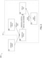
- the system may include at least one offboard source 312 and/or an aircraft 302, which may include at least one user (e.g., flight crew and/or pilot(s)), at least one display unit computing device 304, at least one aircraft computing device 306, at least one radar computing device 308, and/or at least one user interface 310, some or all of which may be communicatively coupled at any given time.
- at least one user e.g., flight crew and/or pilot(s)
- at least one display unit computing device 304 e.g., at least one aircraft computing device 306, at least one radar computing device 308, and/or at least one user interface 310, some or all of which may be communicatively coupled at any given time.
- the at least one display unit computing device 304, the at least one aircraft computing device 306, the at least one radar computing device 308, and/or the at least one user interface 310 may be implemented as a single computing device or any number of computing devices configured to perform (e.g., collectively perform if more than one computing device) any or all of the operations disclosed throughout.
- the at least one display unit computing device 304, the at least one aircraft computing device 306, the at least one radar computing device 308, and/or the at least one user interface 310 may be installed in the aircraft 302.
- the at least one display unit computing device 304, the at least one aircraft computing device 306, the at least one radar computing device 308, the at least one user interface 310, and/or a user may be located offboard of the aircraft 302, for example, if a given aircraft 302 is a remote piloted aircraft (e.g., an unmanned aerial vehicle (UAV) or a drone aircraft).
- a remote piloted aircraft e.g., an unmanned aerial vehicle (UAV) or a drone aircraft.
- the user may be a pilot or crew member.
- the user may interface with the system 300 via the at least one user interface 310.
- the at least one user interface 310 may be implemented as any suitable user interface, such as a control panel, a touchscreen (e.g., of the display unit computing device 304 and/or another display unit), a multipurpose control panel, a control panel integrated into a flight deck, a cursor control panel (CCP) (sometimes referred to as a display control panel (DCP)), a keyboard, a mouse, a trackpad, at least one hardware button, a switch, an eye tracking system, and/or a voice recognition system.
- a control panel e.g., of the display unit computing device 304 and/or another display unit
- CCP cursor control panel
- DCP display control panel
- the user interface 310 may be configured to receive at least one user input and to output the at least one user input to a computing device (e.g., 304, 306, and/or 308).
- a pilot of the aircraft 302 may be able to interface with the user interface 310 to: make a user selection (e.g., a weather radar mode selection) indicating whether to display a horizontal weather radar image 100 and/or a highest priority azimuth slice vertical radar image 200.
- the weather radar mode selection may indicate to display either or both of the horizontal weather radar image 100 and/or the highest priority azimuth slice vertical radar image 200.
- such user inputs may be output to the radar computing device 308 and/or the display unit computing device 304.
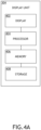
- the display unit computing device 304 may be implemented as any suitable computing device, such as a primary flight display (PFD) computing device, a weather radar display computing device (e.g., a VSD computing device), and/or a multifunction window (MFW) display computing device. As shown in FIGS. 4A and 4B , the display unit computing device 304 may include at least one display 402, at least one processor 404 (e.g., at least one horizontal display processor 404A and/or at least one vertical display processor 404B), at least one memory 406, and/or at least one storage 410, some or all of which may be communicatively coupled at any given time.
- PFD primary flight display
- MMW multifunction window
- the at least one processor 404 may include at least one central processing unit (CPU), at least one graphics processing unit (GPU), at least one field-programmable gate array (FPGA), at least one application specific integrated circuit (ASIC), at least one digital signal processor, at least one virtual machine (VM) running on at least one processor, and/or the like configured to perform (e.g., collectively perform) any of the operations disclosed throughout.
- the at least one processor 404 may include a CPU and a GPU configured to perform (e.g., collectively perform) any of the operations disclosed throughout.
- the processor 404 may be configured to run various software applications (e.g., a weather radar display application, a PFD application, and/or an MFW application) or computer code stored (e.g., maintained) in a non-transitory computer-readable medium (e.g., memory 406 and/or storage 410) and configured to execute various instructions or operations.
- the processor 404 may be configured to perform any or all of the operations disclosed throughout.
- the processor 404 may be configured to: receive at least one a horizontal weather radar image 100 as graphical data (e.g., from the radar computing device 308) and/or at least one highest priority azimuth slice vertical radar image 200 (e.g., from the radar computing device 308).
- the display 402 may be configured to display one or both of the at least one a horizontal weather radar image 100 or the at least one at least one highest priority azimuth slice vertical radar image 200, as well as other information.
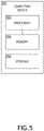
- the at least one aircraft computing device 306 may be implemented as any suitable computing device, such as a flight management system (FMS) computing device, a flight data computer, an inertial reference unit (IRU), or a global positioning system (GPS) device.
- the at least one aircraft computing device 306 may include any or all of the elements, as shown in FIG. 5 .
- the aircraft computing device 306 may include at least one processor 502, at least one memory 504, and/or at least one storage 506, some or all of which may be communicatively coupled at any given time.
- the at least one processor 502 may include at least one central processing unit (CPU), at least one graphics processing unit (GPU), at least one field-programmable gate array (FPGA), at least one application specific integrated circuit (ASIC), at least one digital signal processor, at least one virtual machine (VM) running on at least one processor, and/or the like configured to perform (e.g., collectively perform) any of the operations disclosed throughout.
- the at least one processor 502 may include a CPU and a GPU configured to perform (e.g., collectively perform) any of the operations disclosed throughout.
- the processor 502 may be configured to run various software applications (e.g., an FMS application, a flight data computer application, an IRU application, and/or a GPS application) or computer code stored (e.g., maintained) in a non-transitory computer-readable medium (e.g., memory 504 and/or storage 506) and configured to execute various instructions or operations.
- the processor 502 of the aircraft computing device 306 may be configured to perform any or all of the operations disclosed throughout.
- the processor 502 of the computing device 210A may be configured to: output aircraft data (e.g., information of altitude of the aircraft 302, information of a position of the aircraft 302, information of a flight plan, information of an air temperature outside of the aircraft 302, FMS data, flight path data, GPS data, inertial reference unit (IRU) data, flight data, and/or flight computer data) to the display unit computing device 304 and/or the radar computing device 308.
- aircraft data e.g., information of altitude of the aircraft 302, information of a position of the aircraft 302, information of a flight plan, information of an air temperature outside of the aircraft 302, FMS data, flight path data, GPS data, inertial reference unit (IRU) data, flight data, and/or flight computer data
- the at least one radar computing device 308 may be implemented as any suitable computing device, such as a weather radar computing device.
- the at least one radar computing device 308 may include any or all of the elements shown in FIG. 6 .
- the radar computing device 308 may include at least one radar antenna 601, at least one processor 602, at least one memory 604, and/or at least one storage 606, some or all of which may be communicatively coupled at any given time.
- the at least one processor 602 may include at least one central processing unit (CPU), at least one graphics processing unit (GPU), at least one field-programmable gate array (FPGA), at least one application specific integrated circuit (ASIC), at least one digital signal processor, at least one virtual machine (VM) running on at least one processor, and/or the like configured to perform (e.g., collectively perform) any of the operations disclosed throughout.
- the at least one processor 602 may include a CPU and a GPU configured to perform (e.g., collectively perform) any of the operations disclosed throughout.
- the processor 602 may be configured to run various software applications (e.g., a radar application) or computer code stored (e.g., maintained) in a non-transitory computer-readable medium (e.g., memory 604 and/or storage 606) and configured to execute various instructions or operations.
- the processor 602 of the radar computing device 308 may be configured to perform any or all of the operations disclosed throughout.
- the processor 602 may be configured to: obtain (e.g., from the aircraft computing device 306) aircraft data associated with an aircraft 302, wherein the aircraft data may include information of an aircraft position of the aircraft 302, an aircraft altitude of the aircraft 302, and/or a flight plan of the aircraft 302; obtain (e.g., from the offboard source 312 (e.g., a satellite(s) and/or a ground radar system(s))) or generate two-dimensional weather radar reflectivity data for a region proximate to the aircraft position, wherein the two-dimensional weather radar reflectivity data may include and/or be based on at least one of horizontal weather radar scans or vertical weather radar scans; break down the two-dimensional weather radar reflectivity data into cells (e.g., utilize image processing to break down the two-dimensional weather radar reflectivity data into cells), wherein each cell of the cells may have a maximum rainfall rate location and a geometric area; compute storm top information of a given cell and information of a growth rate of the given cell for each cell of the cells
- cell intensity may refer to a measurement of the reflectivity within the cell.
- cell intensity may simply be the maximum reflectivity measured within the cell.
- cell intensity may also be measured in other ways, such as the area of a measured reflectivity within the cell (e.g., the area of 40 dBz within the cell boundaries).
- cell growth rate may refer to the growth in altitude of a reference reflectivity level within the cell (e.g., ususally 18 to 20 dBz). Cell growth rate is usually measured in feet per minute.
- convective level may refer to a measurement of convectiveness.
- a measurement of convectiveness may be done in multiple ways.
- an index for convective levels may be based on echo top, max reflectivity, reflectivity areas, gradient of reflectivity within the cell, and/or lightning rate.
- the processor 602 may be further configured to: prioritize the cells based at least on the at least one of each cell's proximity to the aircraft, each cell's intensity, each cell's growth rate, each cell's storm top altitude relative to the aircraft altitude, or the threat convective level of the cell to select, using hysteresis, the highest priority cell to ensure that a selection of the highest priority cell does not change for at least a predetermined amount of time (e.g., 10 seconds, 30 seconds, 1 minute, 5 minutes, or more). For example, using such hysteresis may prevent rapid changes in determined highest priority cells that might make it difficult for a pilot to focus on a single highest priority azimuth slice vertical radar image 200 at a given time.
- hysteresis may prevent rapid changes in determined highest priority cells that might make it difficult for a pilot to focus on a single highest priority azimuth slice vertical radar image 200 at a given time.
- At least one processor may be configured to (e.g., collectively configured to, if more than one processor): obtain aircraft data associated with an aircraft 302, the aircraft data including information of an aircraft position of the aircraft 302 and an aircraft altitude of the aircraft; obtain or generate two-dimensional weather radar reflectivity data for a region proximate to the aircraft position, the two-dimensional weather radar reflectivity data including or based on at least one of horizontal weather radar scans or vertical weather radar scans; break down the two-dimensional weather radar reflectivity data into cells (e.g., utilize image processing to break down the two-dimensional weather radar reflectivity data into cells), each cell of the cells having a maximum rainfall rate location and a geometric area; compute storm top information of a given cell and information of a growth rate of the given cell for each cell of the cells from the
- the at least one processor may include at least one display unit computing device processor 404 (e.g., the at least one processor 404A and/or the at least one processor 404B) and at least one radar computing device processor 602, the at least one display unit computing device processor 404 and the at least one radar computing device processor 602 being communicatively coupled, wherein one or more of the at least one processor (e.g., the at least one processor 404 (e.g., the at least one processor 404A and/or the at least one processor 404B), and/or the at least one processor 602) is configured to obtain the aircraft data from at least one aircraft computing device 306.
- the at least one processor 404 e.g., the at least one processor 404A and/or the at least one processor 404B
- the at least one processor 602 may include at least one display unit computing device processor 404 (e.g., the at least one processor 404A and/or the at least one processor 404B) and at least one radar computing device processor 602, the at least one display
- the at least one display unit computing device processor 404 may comprise at least one horizontal display processor 404A and at least one vertical display processor 404B, wherein one or more of the at least one processor (e.g., the at least one processor 404 (e.g., the at least one processor 404A and/or the at least one processor 404B), and/or the at least one processor 602) is configured to receive a user selection to display a horizontal weather radar image 100 and/or the highest priority azimuth slice vertical radar image 200. For example, if the user selection is for the horizontal weather radar image 100, the at least one horizontal display processor 404A may be configured to display the horizontal weather radar image 100.
- the at least one vertical display processor 404B may be configured to display the highest priority azimuth slice vertical radar image 200.
- the at least one radar computing device processor 602 may be configured to: determine that the highest priority azimuth slice vertical radar image 100 is severe based at least on at least one of the highest priority cell being along a flight plan and/or the highest priority cell being within a predetermined distance of the flight plan and/or of the aircraft position; and/or override the user selection to cause the at least one vertical display processor 404B to output the highest priority azimuth slice vertical radar image 200 to the display 402.
- At least one processor e.g., the at least one processor 404 (e.g., the at least one processor 404A and/or the at least one processor 404B), the at least one processor 502, and/or the at least one processor 602) of the aircraft 302 may be configured to perform (e.g., collectively perform) any or all of the operations disclosed throughout.
- an exemplary embodiment of a method 700 may include one or more of the following steps. Additionally, for example, some embodiments may include performing one or more instances of the method 700 iteratively, concurrently, and/or sequentially. Additionally, for example, at least some of the steps of the method 700 may be performed in parallel and/or concurrently. Additionally, in some embodiments, at least some of the steps of the method 700 may be performed non-sequentially.
- a step 702 may include obtaining, by at least one processor communicatively coupled to a display, aircraft data associated with an aircraft, the aircraft data including information of an aircraft position of the aircraft and an aircraft altitude of the aircraft.
- a step 704 may include obtaining or generating, by the at least one processor, two-dimensional weather radar reflectivity data for a region proximate to the aircraft position, the two-dimensional weather radar reflectivity data including or based on at least one of horizontal weather radar scans or vertical weather radar scans.
- a step 706 may include breaking down, by the at least one processor, the two-dimensional weather radar reflectivity data into cells, each cell of the cells having a maximum rainfall rate location and a geometric area (e.g., utilizing, by the at least one processor, image processing to break down the two-dimensional weather radar reflectivity data into cells, each cell of the cells having a maximum rainfall rate location and a geometric area).
- a step 708 may include computing, by the at least one processor, storm top information of a given cell and information of a growth rate of the given cell for each cell of the cells from the two-dimensional weather radar reflectivity data.
- a step 710 may include prioritizing, by the at least one processor, the cells based at least on at least one of each cell's proximity to the aircraft, each cell's intensity, each cell's growth rate, each cell's storm top altitude relative to the aircraft altitude, or a threat convective level of the cell to select a highest priority cell.
- a step 712 may include outputting, by the at least one processor to the display, a highest priority azimuth slice vertical radar image of the two-dimensional weather radar reflectivity data as graphical data, the highest priority azimuth slice vertical radar image corresponding to an azimuth slice of the two-dimensional weather radar reflectivity data for the highest priority cell.
- a step 714 may include displaying, by the display, the highest priority azimuth slice vertical radar image to a user.
- method 700 may include any of the operations disclosed throughout.
- embodiments of the inventive concepts disclosed herein may be directed to a system (e.g., an aircraft system) and a method configured to select and display a prioritized (e.g., a highest priority) azimuth slice vertical radar image of a two-dimensional weather radar reflectivity data.
- a prioritized e.g., a highest priority
- At least one non-transitory computer-readable medium may refer to as at least one non-transitory computer-readable medium (e.g., at least one computer-readable medium implemented as hardware; e.g., at least one non-transitory processor-readable medium, at least one memory (e.g., at least one nonvolatile memory, at least one volatile memory, or a combination thereof; e.g., at least one random-access memory, at least one flash memory, at least one read-only memory (ROM) (e.g., at least one electrically erasable programmable read-only memory (EEPROM)), at least one on-processor memory (e.g., at least one on-processor cache, at least one on-processor buffer, at least one on-processor flash memory, at least one on-processor EEPROM, or a combination thereof), or a combination thereof), at least one storage device (e.g., at least one hard-disk drive, at
- At least one means one or a plurality of; for example, “at least one” may comprise one, two, three, ..., one hundred, or more.
- one or more means one or a plurality of; for example, “one or more” may comprise one, two, three, ..., one hundred, or more.
- zero or more means zero, one, or a plurality of; for example, “zero or more” may comprise zero, one, two, three, ..., one hundred, or more.
- the methods, operations, and/or functionality disclosed may be implemented as sets of instructions or software readable by a device. Further, it is understood that the specific order or hierarchy of steps in the methods, operations, and/or functionality disclosed are examples of exemplary approaches. Based upon design preferences, it is understood that the specific order or hierarchy of steps in the methods, operations, and/or functionality can be rearranged while remaining within the scope of the inventive concepts disclosed herein.
- the accompanying claims may present elements of the various steps in a sample order, and are not necessarily meant to be limited to the specific order or hierarchy presented.
- embodiments of the methods according to the inventive concepts disclosed herein may include one or more of the steps described herein. Further, such steps may be carried out in any desired order and two or more of the steps may be carried out simultaneously with one another. Two or more of the steps disclosed herein may be combined in a single step, and in some embodiments, one or more of the steps may be carried out as two or more sub-steps. Further, other steps or sub-steps may be carried in addition to, or as substitutes to one or more of the steps disclosed herein.
Landscapes
- Engineering & Computer Science (AREA)
- Remote Sensing (AREA)
- Radar, Positioning & Navigation (AREA)
- Physics & Mathematics (AREA)
- General Physics & Mathematics (AREA)
- Computer Networks & Wireless Communication (AREA)
- Aviation & Aerospace Engineering (AREA)
- Electromagnetism (AREA)
- Theoretical Computer Science (AREA)
- Life Sciences & Earth Sciences (AREA)
- Atmospheric Sciences (AREA)
- Radar Systems Or Details Thereof (AREA)
Applications Claiming Priority (1)
| Application Number | Priority Date | Filing Date | Title |
|---|---|---|---|
| US17/482,888 US11852745B2 (en) | 2021-09-23 | 2021-09-23 | System and method to select and display prioritized azimuth slice vertical radar image |
Publications (1)
| Publication Number | Publication Date |
|---|---|
| EP4155772A1 true EP4155772A1 (fr) | 2023-03-29 |
Family
ID=83438278
Family Applications (1)
| Application Number | Title | Priority Date | Filing Date |
|---|---|---|---|
| EP22197545.1A Pending EP4155772A1 (fr) | 2021-09-23 | 2022-09-23 | Système et procédé de sélection et d'affichage d'image radar vertical à tranche azimutale priorisée |
Country Status (2)
| Country | Link |
|---|---|
| US (1) | US11852745B2 (fr) |
| EP (1) | EP4155772A1 (fr) |
Families Citing this family (1)
| Publication number | Priority date | Publication date | Assignee | Title |
|---|---|---|---|---|
| US11852745B2 (en) * | 2021-09-23 | 2023-12-26 | Rockwell Collins, Inc. | System and method to select and display prioritized azimuth slice vertical radar image |
Citations (4)
| Publication number | Priority date | Publication date | Assignee | Title |
|---|---|---|---|---|
| EP2461177A1 (fr) * | 2010-12-02 | 2012-06-06 | Honeywell International, Inc. | Systèmes et procédés pour améliorer la détermination de la météorologie correspondante |
| EP2966408A1 (fr) * | 2014-07-08 | 2016-01-13 | Honeywell International Inc. | Affichage du profil vertical pour aeronef comprenant des icônes météorologiques |
| US20160041305A1 (en) * | 2014-08-11 | 2016-02-11 | The Boeing Company | 4d volumetric weather data processing and display |
| EP3748399A1 (fr) * | 2019-06-07 | 2020-12-09 | Honeywell International Inc. | Systèmes et procédés permettant de déterminer la croissance de cellules par convection à partir de données de réflectivité de radar météorologique |
Family Cites Families (34)
| Publication number | Priority date | Publication date | Assignee | Title |
|---|---|---|---|---|
| US4829308A (en) * | 1985-10-07 | 1989-05-09 | Raytheon Company | Raster display system |
| US5680138A (en) * | 1995-12-15 | 1997-10-21 | Lockheed Martin Corporation | Synthetic aperture radar simulation |
| US6043757A (en) | 1998-06-12 | 2000-03-28 | The Boeing Company | Dynamic, multi-attribute hazard prioritization system for aircraft |
| WO2003005060A1 (fr) * | 2001-07-03 | 2003-01-16 | Honeywell International Inc. | Affichage du profil vertical a plan arbitraire |
| US8902100B1 (en) * | 2008-03-07 | 2014-12-02 | Rockwell Collins, Inc. | System and method for turbulence detection |
| US7109913B1 (en) * | 2004-05-04 | 2006-09-19 | Rockwell Collins, Inc. | Airborne weather radar system and radar display |
| US6879280B1 (en) * | 2004-06-28 | 2005-04-12 | Rockwell Collins, Inc. | Vertical weather profile display system and method |
| US7242343B1 (en) * | 2004-09-15 | 2007-07-10 | Rockwell Collins, Inc. | Directed sequential hazard assessment weather radar |
| US7868811B1 (en) * | 2006-03-07 | 2011-01-11 | Rockwell Collins, Inc. | Weather radar system and method using data from a lightning sensor |
| US20090177343A1 (en) * | 2008-01-09 | 2009-07-09 | Honeywell International Inc. | System and method for selectable weather object display |
| US9244167B1 (en) * | 2008-03-07 | 2016-01-26 | Rockwell Collins, Inc. | Long range weather information display system and method |
| US7696921B1 (en) * | 2008-05-06 | 2010-04-13 | Rockwell Collins, Inc. | System and method for turbulence detection |
| US9170125B2 (en) * | 2008-09-04 | 2015-10-27 | The Boeing Company | Presenting weather information on a display |
| US20100194628A1 (en) | 2009-02-05 | 2010-08-05 | Honeywell International Inc. | Systems and methods for displaying radar-measured turbulence intensity on a vertical display |
| US8111186B2 (en) * | 2009-12-17 | 2012-02-07 | Honeywell International Inc. | Systems and methods for infering hail and lightning using an airborne weather radar volumetric buffer |
| US8786486B1 (en) * | 2011-09-27 | 2014-07-22 | Rockwell Collins, Inc. | System and method for providing weather radar status |
| US9823347B1 (en) * | 2014-03-12 | 2017-11-21 | Rockwell Collins, Inc. | Weather radar system and method for high altitude crystal warning interface |
| US9019147B1 (en) * | 2012-01-30 | 2015-04-28 | Rockwell Collins, Inc. | System and method for displaying weather information |
| US9134418B1 (en) * | 2013-03-15 | 2015-09-15 | Rockwell Collins, Inc. | Weather hazard threat level computation and display |
| US9535158B1 (en) * | 2013-11-21 | 2017-01-03 | Rockwell Collins, Inc. | Weather radar system and method with fusion of multiple weather information sources |
| US9292913B2 (en) * | 2014-01-31 | 2016-03-22 | Pictometry International Corp. | Augmented three dimensional point collection of vertical structures |
| FR3021107B1 (fr) * | 2014-05-16 | 2018-01-26 | Thales | Procede d'aide a la navigation d'un aeronef avec correlation d'informations dynamiques avec une trajectoire de vol 4d |
| US9710218B2 (en) * | 2014-07-08 | 2017-07-18 | Honeywell International Inc. | Vertical profile display including hazard band indication |
| US9869766B1 (en) * | 2015-01-28 | 2018-01-16 | Rockwell Collins, Inc. | Enhancement of airborne weather radar performance using external weather data |
| JP6409680B2 (ja) * | 2015-05-29 | 2018-10-24 | 株式会社デンソー | 運転支援装置、運転支援方法 |
| CN108885257A (zh) * | 2016-04-11 | 2018-11-23 | 古野电气株式会社 | 信号处理装置以及雷达装置 |
| US10365365B2 (en) * | 2016-11-30 | 2019-07-30 | Honeywell International Inc. | Enhanced weather radar mapping |
| GB2575561B (en) * | 2017-03-31 | 2022-06-08 | FLIR Belgium BVBA | Visually correlated radar systems and methods |
| US11080526B2 (en) * | 2017-08-15 | 2021-08-03 | Regents Of The University Of Minnesota | Satellite image classification across multiple resolutions and time using ordering constraint among instances |
| US10417916B2 (en) * | 2017-10-11 | 2019-09-17 | Honeywell International Inc. | Method and system to provide contextual auto-correlation of vertical situational display objects to objects displayed on a lateral map display based on a priority scheme |
| KR102212524B1 (ko) * | 2020-07-15 | 2021-02-05 | 대한민국 | 기상 레이더의 소실된 시선속도 복원 방법, 이를 수행하기 위한 기록 매체 및 장치 |
| US11474199B2 (en) * | 2020-09-03 | 2022-10-18 | Vaisala, Inc. | RFI mitigation in weather radar data |
| US11852745B2 (en) * | 2021-09-23 | 2023-12-26 | Rockwell Collins, Inc. | System and method to select and display prioritized azimuth slice vertical radar image |
| US20230131160A1 (en) * | 2021-10-21 | 2023-04-27 | Honeywell International Inc. | Weather radar short-term forecast for in-flight cockpit displays |
-
2021
- 2021-09-23 US US17/482,888 patent/US11852745B2/en active Active
-
2022
- 2022-09-23 EP EP22197545.1A patent/EP4155772A1/fr active Pending
Patent Citations (4)
| Publication number | Priority date | Publication date | Assignee | Title |
|---|---|---|---|---|
| EP2461177A1 (fr) * | 2010-12-02 | 2012-06-06 | Honeywell International, Inc. | Systèmes et procédés pour améliorer la détermination de la météorologie correspondante |
| EP2966408A1 (fr) * | 2014-07-08 | 2016-01-13 | Honeywell International Inc. | Affichage du profil vertical pour aeronef comprenant des icônes météorologiques |
| US20160041305A1 (en) * | 2014-08-11 | 2016-02-11 | The Boeing Company | 4d volumetric weather data processing and display |
| EP3748399A1 (fr) * | 2019-06-07 | 2020-12-09 | Honeywell International Inc. | Systèmes et procédés permettant de déterminer la croissance de cellules par convection à partir de données de réflectivité de radar météorologique |
Also Published As
| Publication number | Publication date |
|---|---|
| US20230088985A1 (en) | 2023-03-23 |
| US11852745B2 (en) | 2023-12-26 |
Similar Documents
| Publication | Publication Date | Title |
|---|---|---|
| US10175388B2 (en) | 4D volumetric weather data processing and display | |
| EP2899509B1 (fr) | Procédé et appareil d'affichage des informations d'itinéraire de vol dans un giravion | |
| US9322914B1 (en) | Aviation display depiction of weather threats | |
| US11783716B2 (en) | Return flight control method and device for unmanned aerial vehicle, and unmanned aerial vehicle | |
| US9523580B2 (en) | System and method for aiding a pilot in locating an out of view landing site | |
| US9558674B2 (en) | Aircraft systems and methods to display enhanced runway lighting | |
| CN109491399B (zh) | 自动飞行控制系统和方法 | |
| EP3748399B1 (fr) | Systèmes et procédés permettant de déterminer la croissance de cellules par convection à partir de données de réflectivité de radar météorologique | |
| CN108983796B (zh) | 用于调整飞行器的视觉显示视角与飞行路径之间的相关性的系统和方法 | |
| US10242582B1 (en) | Visualization of glide distance for increased situational awareness | |
| US11320842B2 (en) | Systems and methods for optimized cruise vertical path | |
| EP4155772A1 (fr) | Système et procédé de sélection et d'affichage d'image radar vertical à tranche azimutale priorisée | |
| US9000972B1 (en) | System and method for enabling display of vertical weather information on an aircraft horizontal weather display | |
| US9019147B1 (en) | System and method for displaying weather information | |
| US8786486B1 (en) | System and method for providing weather radar status | |
| US11837101B2 (en) | System and method to display aircraft relative storm top image | |
| EP4166985A1 (fr) | Système et procédé pour régler ou supprimer un seuil d'alerte de cisaillement du vent pour radar météorologique | |
| US10597167B1 (en) | Time to altitude display system and method | |
| US10788325B1 (en) | Systems and methods for hybrid graph and grid three-dimensional routing | |
| US20220092991A1 (en) | Aircraft system and method to display air traffic indicators | |
| US11501647B2 (en) | Estimated wake turbulence trail for aircraft system | |
| US11543520B2 (en) | Aircraft system and method to display three-dimensional threat image | |
| US20210316879A1 (en) | System and method to change map range of airport moving map | |
| US20240019572A1 (en) | Displaying weather information corresponding to a selected region | |
| US20230103832A1 (en) | Air traffic depiction for portable and installed aircraft displays |
Legal Events
| Date | Code | Title | Description |
|---|---|---|---|
| PUAI | Public reference made under article 153(3) epc to a published international application that has entered the european phase |
Free format text: ORIGINAL CODE: 0009012 |
|
| STAA | Information on the status of an ep patent application or granted ep patent |
Free format text: STATUS: THE APPLICATION HAS BEEN PUBLISHED |
|
| AK | Designated contracting states |
Kind code of ref document: A1 Designated state(s): AL AT BE BG CH CY CZ DE DK EE ES FI FR GB GR HR HU IE IS IT LI LT LU LV MC MK MT NL NO PL PT RO RS SE SI SK SM TR |
|
| STAA | Information on the status of an ep patent application or granted ep patent |
Free format text: STATUS: REQUEST FOR EXAMINATION WAS MADE |
|
| 17P | Request for examination filed |
Effective date: 20230928 |
|
| RBV | Designated contracting states (corrected) |
Designated state(s): AL AT BE BG CH CY CZ DE DK EE ES FI FR GB GR HR HU IE IS IT LI LT LU LV MC MK MT NL NO PL PT RO RS SE SI SK SM TR |
|
| STAA | Information on the status of an ep patent application or granted ep patent |
Free format text: STATUS: EXAMINATION IS IN PROGRESS |
|
| 17Q | First examination report despatched |
Effective date: 20240212 |