EP4152039B1 - Verfahren und positionierungs-engine zur bestimmung einer position einer mobilen vorrichtung - Google Patents
Verfahren und positionierungs-engine zur bestimmung einer position einer mobilen vorrichtung Download PDFInfo
- Publication number
- EP4152039B1 EP4152039B1 EP21197751.7A EP21197751A EP4152039B1 EP 4152039 B1 EP4152039 B1 EP 4152039B1 EP 21197751 A EP21197751 A EP 21197751A EP 4152039 B1 EP4152039 B1 EP 4152039B1
- Authority
- EP
- European Patent Office
- Prior art keywords
- mobile device
- locus
- distance
- position information
- loci
- Prior art date
- Legal status (The legal status is an assumption and is not a legal conclusion. Google has not performed a legal analysis and makes no representation as to the accuracy of the status listed.)
- Active
Links
Images

Classifications
-
- G—PHYSICS
- G01—MEASURING; TESTING
- G01S—RADIO DIRECTION-FINDING; RADIO NAVIGATION; DETERMINING DISTANCE OR VELOCITY BY USE OF RADIO WAVES; LOCATING OR PRESENCE-DETECTING BY USE OF THE REFLECTION OR RERADIATION OF RADIO WAVES; ANALOGOUS ARRANGEMENTS USING OTHER WAVES
- G01S5/00—Position-fixing by co-ordinating two or more direction or position line determinations; Position-fixing by co-ordinating two or more distance determinations
- G01S5/02—Position-fixing by co-ordinating two or more direction or position line determinations; Position-fixing by co-ordinating two or more distance determinations using radio waves
- G01S5/0278—Position-fixing by co-ordinating two or more direction or position line determinations; Position-fixing by co-ordinating two or more distance determinations using radio waves involving statistical or probabilistic considerations
-
- G—PHYSICS
- G01—MEASURING; TESTING
- G01S—RADIO DIRECTION-FINDING; RADIO NAVIGATION; DETERMINING DISTANCE OR VELOCITY BY USE OF RADIO WAVES; LOCATING OR PRESENCE-DETECTING BY USE OF THE REFLECTION OR RERADIATION OF RADIO WAVES; ANALOGOUS ARRANGEMENTS USING OTHER WAVES
- G01S5/00—Position-fixing by co-ordinating two or more direction or position line determinations; Position-fixing by co-ordinating two or more distance determinations
- G01S5/02—Position-fixing by co-ordinating two or more direction or position line determinations; Position-fixing by co-ordinating two or more distance determinations using radio waves
- G01S5/0205—Details
- G01S5/0244—Accuracy or reliability of position solution or of measurements contributing thereto
-
- G—PHYSICS
- G01—MEASURING; TESTING
- G01S—RADIO DIRECTION-FINDING; RADIO NAVIGATION; DETERMINING DISTANCE OR VELOCITY BY USE OF RADIO WAVES; LOCATING OR PRESENCE-DETECTING BY USE OF THE REFLECTION OR RERADIATION OF RADIO WAVES; ANALOGOUS ARRANGEMENTS USING OTHER WAVES
- G01S5/00—Position-fixing by co-ordinating two or more direction or position line determinations; Position-fixing by co-ordinating two or more distance determinations
- G01S5/02—Position-fixing by co-ordinating two or more direction or position line determinations; Position-fixing by co-ordinating two or more distance determinations using radio waves
- G01S5/0205—Details
-
- G—PHYSICS
- G01—MEASURING; TESTING
- G01S—RADIO DIRECTION-FINDING; RADIO NAVIGATION; DETERMINING DISTANCE OR VELOCITY BY USE OF RADIO WAVES; LOCATING OR PRESENCE-DETECTING BY USE OF THE REFLECTION OR RERADIATION OF RADIO WAVES; ANALOGOUS ARRANGEMENTS USING OTHER WAVES
- G01S5/00—Position-fixing by co-ordinating two or more direction or position line determinations; Position-fixing by co-ordinating two or more distance determinations
- G01S5/02—Position-fixing by co-ordinating two or more direction or position line determinations; Position-fixing by co-ordinating two or more distance determinations using radio waves
- G01S5/0284—Relative positioning
-
- G—PHYSICS
- G01—MEASURING; TESTING
- G01S—RADIO DIRECTION-FINDING; RADIO NAVIGATION; DETERMINING DISTANCE OR VELOCITY BY USE OF RADIO WAVES; LOCATING OR PRESENCE-DETECTING BY USE OF THE REFLECTION OR RERADIATION OF RADIO WAVES; ANALOGOUS ARRANGEMENTS USING OTHER WAVES
- G01S5/00—Position-fixing by co-ordinating two or more direction or position line determinations; Position-fixing by co-ordinating two or more distance determinations
- G01S5/02—Position-fixing by co-ordinating two or more direction or position line determinations; Position-fixing by co-ordinating two or more distance determinations using radio waves
- G01S5/14—Determining absolute distances from a plurality of spaced points of known location
-
- G—PHYSICS
- G06—COMPUTING OR CALCULATING; COUNTING
- G06F—ELECTRIC DIGITAL DATA PROCESSING
- G06F17/00—Digital computing or data processing equipment or methods, specially adapted for specific functions
- G06F17/10—Complex mathematical operations
- G06F17/17—Function evaluation by approximation methods, e.g. inter- or extrapolation, smoothing, least mean square method
-
- H—ELECTRICITY
- H04—ELECTRIC COMMUNICATION TECHNIQUE
- H04W—WIRELESS COMMUNICATION NETWORKS
- H04W4/00—Services specially adapted for wireless communication networks; Facilities therefor
- H04W4/02—Services making use of location information
- H04W4/023—Services making use of location information using mutual or relative location information between multiple location based services [LBS] targets or of distance thresholds
-
- H—ELECTRICITY
- H04—ELECTRIC COMMUNICATION TECHNIQUE
- H04W—WIRELESS COMMUNICATION NETWORKS
- H04W4/00—Services specially adapted for wireless communication networks; Facilities therefor
- H04W4/02—Services making use of location information
- H04W4/025—Services making use of location information using location based information parameters
Definitions
- This disclosure relates to a method and to a positioning engine for determining a position of a mobile device.
- the disclosure further relates to a computer program product and a non-volatile storage medium.
- one key element is to determine a position of a mobile device like a tag based on position information relative to multiple anchor points. Such determination is for example performed in a positioning engine using various mathematical models.
- an accuracy of the determined position of the mobile device depends on the accuracy of the relative position information of each anchor point only. Hence, if an anchor point provides wrong or inaccurate relative position information for various reasons, the determined position of the mobile device will be less accurate too.
- An object to be achieved is to provide an improved processing concept that allows an improved determination of a position of a mobile device with a higher accuracy.
- determination of a position of a mobile device includes, for each of a plurality of anchor points, receiving respective relative position information between the respective anchor point and the mobile device such that the received relative position information for the plurality of anchor points forms a set of position information.
- Each relative position information includes one of i) a direction between the respective anchor point and the mobile device, ii) a distance between the respective anchor point and the mobile device, and iii) a direction and a distance between the respective anchor point and the mobile device.
- Directions are assumed to be defined in 3-dimensional, 3D, space.
- the improved processing concept is based on the insight that initially an estimated position of the mobile device is determined based on the set of position information.
- Such an estimated position may be subject to inaccuracies due to wrong or inaccurate relative position information in the set of position information.
- weight factors are introduced that reduce the influence of the inaccurate relative position information on the overall determined position of the mobile device.
- each one or two of the relative position information defines a locus for possible positions of the mobile device.
- a locus plural 'loci', is a set of all points, commonly a line, a line segment, a curve or a plane, whose location satisfies or is determined by one or more specified conditions that are e.g. given by respective equations.
- the specified conditions are given by the relative position information.
- the process may be performed iteratively such that, for example in a subsequent iteration step, the refined position of the previous iteration step is used as the estimated position such that the determination of the distance values of the loci to the estimated position and the respective determination of the weight factors is based on the previously determined refined position of the mobile device.
- the iteration can be performed for a predetermined number of iteration steps or until an exit criterion is achieved.
- a set of loci is defined, each locus of the set of loci being based on one or more of the relative position information from the set of position information. For each locus of the set of loci, a distance value between the estimated position of the mobile device and the respective locus is determined. Furthermore, for each locus of the set of loci, a weight factor is determined as a function of the determined distance values. A refined position of the mobile device is determined based on the set of position information and the determined weight factors.
- the determination of the estimated position of the mobile device is performed with a linear equation system solved with a least squares, LS, approach.
- the determination of the refined position of the mobile device may be performed with the linear equation system solved with a weighted least squares, WLS, approach based on the determined weight factors.
- WLS approach employs a diagonal weight matrix formed from the determined weight factors.
- the distance values may be determined as the distances, e.g. geometrical distances, between the estimated position of the mobile device and the respective locus.
- the distance values are determined as squared distances, e.g. geometrical distances, between the estimated position of the mobile device and the respective locus. The use of squared distances may reduce the computational effort of the determination since, for example, square root calculations may be avoided.
- the function determining the weight factor for each locus of the set of loci as a function of the determined distance values is monotonically decreasing or strictly decreasing with respect to the associated distance value of the respective locus. For example, the larger the distance value for one locus, the smaller will be the weight factor for that locus, and vice versa.
- the weight factors may be in the range between 0 and 1, such that, for example, for a weight factor of 0, the respective locus is completely ignored while for a weight factor of 1, the locus is completely taken into account.
- Various functions for determining the weight factors are available depending, for example, on the minimum distance value of all distance values of the loci, a sum of all distance values of all loci, a distance threshold value and the distance value for the actual locus. This may be combined with closed form functions employing exponential values. In some implementations the functions may be pre-calculated and stored in a lookup table, LUT, such that the resulting weight factor is retrieved from the LUT based on their actual distance value.
- the refined position of the mobile device is determined further based on quality information for at least one of the plurality of anchor points.
- the quality information for the at least one anchor point is determined from at least one of the following: a signal strength associated with the received relative position of the at least one anchor point, a number of antenna elements of the at least one anchor point, a confidence factor associated with the received relative position of the at least one anchor point, upper and/or lower bounds for the weight factor associated with the at least one anchor point.
- the quality information may be mapped to one or more respective weight matrices, which preferably have the same form as the weight matrices with weight factors determined from the distance values.
- the method may be performed in an iterative fashion such that in an initial iteration step the estimated position is determined based on the set of position information and in each subsequent iteration step the refined position determined in a respective preceding iteration is used as the estimated position for determining the distance values and the weight factors.
- an absolute position of each of the plurality of anchor points is known.
- the method is performed in a positioning engine.
- a positioning engine may be a local positioning engine being located in the same area as the anchor points.
- the positioning engine may also be implemented as a service component in a network cloud.
- a positioning engine for determining a position of a mobile device comprises a receiver and a processing unit.
- the receiver is configured for receiving from each of a plurality of anchor points, respective relative position information between the respective anchor point and a mobile device.
- the received relative position information for the plurality of anchor points forms a set of position information.
- Each relative position information is of the form as described above.
- the processing unit is configured for determining an estimated position of the mobile device based on the set of position information, defining a set of loci, each locus of the set of loci being based on one or more of the relative position information from the set of position information, determining, for each locus of the set of loci, a distance value between the estimated position of the mobile device and the respective locus, determining, for each locus of the set of loci, a weight factor as a function of the determined distance values, and determining a refined position of the mobile device based on the set of position information and the determined weight factors.
- a computer program product for determining a position of a mobile device comprises instructions that may be stored in a preferably non-transitory computer-readable storage medium, the instructions enabling a computer system to execute a method according to one of the implementations described above.
- the computer system may be implemented within a positioning engine.
- a computer system may have a processor and a storage medium having computer program instructions stored therein, enabling the processor to execute a method according to one of the implementations described above.
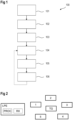
- FIG. 1 shows a flow diagram of an example implementation of a method 100 for determining a position of a mobile device.
- the mobile device can be a tag that transmits or receives a radio frequency, RF, signal, like a Bluetooth direction finding signal, which includes a constant tone extension packet, CTE.
- RF radio frequency
- Other RF signals like Wi-Fi signals, Ultra-wideband, UWB, or cellular signals could be used as an alternative, for example.
- Such signals are transmitted between the mobile device and a plurality of anchor points.
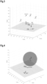
- FIG. 2 an example of a positioning system is shown comprising a positioning engine LPE that includes a processing unit PROC and a receiver RX. Furthermore, the positioning system includes a plurality of anchor points 1, 2, 3, 4, 5. Figure 2 further shows a mobile device TG that further may be comprised by the positioning system. It should be noted that in some implementations the positioning engine LPE can be placed inside one of the anchor points 1-5 or inside the mobile device TG, or even in a network cloud. By transmitting respective signals between the mobile device TG and each of the anchor points 1-5 as described above, relative position information for each of the anchor points 1-5 can be determined by the respective anchor point and/or the mobile device TG.
- Such relative position information includes one of i) a direction between the respective anchor point and the mobile device, ii) a distance between the respective anchor point and the mobile device TG, and iii) a direction and distance between the respective anchor point and the mobile device TG.
- Respective measures for determining such relative position information are known to the skilled person and therefore not described in more detail here.
- step 101 for each of the plurality of anchor points 1-5 the respective relative position information between the respective anchor point and the mobile device TG is received, for example by the receiver RX of the positioning engine LPE, such that the received relative position information for the plurality of anchor points 1-5 forms a set of position information.
- the lower limit of anchor points is e.g. two if direction is included in the relative position information, and e.g. four if only a distance is included in the relative position information received for an anchor point.
- the lower limit depends on the type of relative position information provided by the anchor points to be used, which in detail will be apparent to the skilled reader from the above description.
- a direction may be defined as a directional vector or as a 3D angle of arrival, AoA, or 3D angle of departure, AoD.
- anchor point 1 and anchor point 2 are each able to provide relative position information including a distance between the anchor points 1, 2 and the mobile device TG.
- the mobile device TG is shown at its ground truth position.
- the relative position information includes both a direction and a distance between the anchor point 3 and the mobile device TG.
- the relative position information includes only a direction between the respective anchor points 4, 5 and the mobile device TG, e.g. derived from respective AoA measurements.
- the anchor points 1-5 are responsible for measuring the distance and/or the AoA/AoD among them and the mobile device TG.
- a position of the anchor points 1-5 is assumed to be known.
- each measurement of distance and/or AoA/AoD is being conducted or transformed in such a way with respect to a global coordinate frame that characterizes the room under examination.
- an anchor point measures only a distance.
- An anchor point that measures distance can be, for example, an UWB anchor point or a Bluetooth access point or a Wi-Fi router or any other device capable of estimating a distance between itself and the presumably moving target.
- an anchor defines a sphere, also called a distance sphere, where the center of the sphere is the anchor point 2 itself and the radius equals the measured distance.
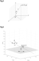
- Anchor A i is located at the point ( x i , y i , z i ) and measures a distance d i . Then, the equation of the distance sphere is given by equation (1), where every quantity is expressed with respect to the room-global coordinate system that is depicted in Figure 3 .
- a spherical coordinate system is a coordinate system for three-dimensional space where the position of a point is specified by three numbers: the radial distance r of that point from a fixed origin, its polar angle ⁇ measured from a fixed zenith direction, and the azimuthal angle ⁇ of its orthogonal projection on a reference plane that passes through the origin and is orthogonal to the zenith, measured from a fixed reference direction on that plane.
- the spherical coordinates vary at the following range: r ⁇ 0 0 ⁇ ⁇ ⁇ ⁇ 0 ⁇ ⁇ ⁇ 2 ⁇ or ⁇ ⁇ ⁇ ⁇ ⁇ ⁇ ⁇
- anchor point 4 is shown that measures a direction between itself and the mobile device TG.
- such an anchor point after the appropriate coordinate transformations, provides two angles ⁇ and ⁇ which are the spherical coordinates of the target, except of the "r". These two angles are measured with respect to the global coordinate axes that have been transferred to the anchor's position without changing its orientation.
- Directional vector ⁇ defines completely a 3D straight line which contains the anchor and the tag, provided that no error has occurred.
- Anchor point 3 is able to measure both distance and AoA.
- a Bluetooth access point which is equipped with an antenna array, is capable to measure both types of information.
- the anchor point 3 is a combination of the previous scenarios and based on equation (3), this anchor point determines a relative positional vector that is pointing to the target, respectively to the mobile device TG.
- the positional vector ⁇ i which can also be called a relative positional vector, should point exactly at the location of the target.
- step 102 an estimated position of the mobile device TG is determined, e.g. with processing unit PROC, based on the set of position information.
- processing unit PROC processing unit
- the information being measured by the anchor points 1 to 5 of this example is exploited.
- a well-known method is to use equations (1), (4), (5) in order to create a system of linear equations and to use an LS approach in order to solve it. This should be demonstrated using the example configuration of Figure 3 , where all types of anchor points are present.
- the following table summarizes the details of all the anchor points 1 to 5. NO.
- anchor points 1 and 2 which measure distance and define spheres given by equation (1).
- equation (6) Before combining all equations from all kind of anchors, we have to normalize the equations that represent planes in the 3D-space. Namely, we transform equation (6) as follows. First we define the scaling factor SF 12 for the plane equation (6), defined by anchors 1 and 2, see equation (7), and then we normalize, see equation (8).
- the first row results from the distance information from anchors 1 and 2
- rows 2-4 result from direction and distance information from anchor 3
- rows 5-8 result from the direction information from anchors 4 and 5, respectively. This also becomes apparent from the indices used.
- Equation (10) is solved by assuming that all anchor points and all equations in the matrix equation (9) are of equal importance and have the same reliability. In the real world, this is not true. Several sources of errors make the equations that form the matrix equation (9), less or more reliable.
- One approach is to use different weights for each equation. For example, in our case we can define a weight matrix and find the solution by using Weighted Least Square, WLS, algorithm.
- each kind of anchor determines a specific locus for the target.
- the equations that describe each locus are the rows of the matrices H and B of the matrix equation (9) as mentioned above.
- step 103 a set of loci is defined, each locus of the set of loci being based on one or more of the relative position information from the set of position information, e.g. according to the above table.
- step 104 for each locus of the set of loci, a distance value between the estimated position of the mobile device (TG) and the respective locus is determined.
- C x ′ C x C x 2 + C y 2 + C z 2
- C y ′ C y C x 2 + C y 2 + C z 2
- C z ′ C z C x 2 + C y 2 + C z 2
- C 0 ′ C 0 C x 2 + C y 2 + C z 2
- C d ′ 1 SF 12 C x 2 + C y 2 + C z 2
- D point x 0 ⁇ x 3 + ⁇ 3 x 2 + y 0 ⁇ y 3 + ⁇ 3 y 2 + z 0 ⁇ z 3 + ⁇ 3 z 2
- D line ⁇ A 4 X 0 ⁇ ⁇ ⁇ ⁇ 4 ⁇
- the distance values are determined as squared distances, e.g. squared geometrical distances, between the estimated position of the mobile device TG and the respective locus.
- squared distances e.g. squared geometrical distances
- the estimated position of the mobile device TG and the respective distances between that estimated position and the loci is used to determine whether a locus behaves as an outlier or not, i.e. whether the respective locus is reasonable with respect to estimated position.
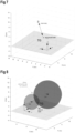
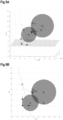
- the respective loci for all five anchor points 1 to 5 are shown, in Figure 9A in a 3D view and in Figure 9B in a 2D view, resembling a top view of Figure 9A .
- the two distance spheres of the anchor points 1 and 2 together with the resulting plane locus are shown, as well as the line loci of anchor points 4 and 5 and the point locus of anchor point 3.
- step 105 the distances of the estimated LS position from all the four loci are used for producing the weights for each one of the rows of the weight matrix W that has been described above in conjunction with equation (11).
- the weights are calculated per locus and not per row of the matrix equation (9).
- the improved processing concept makes the weights dependent on the distance of the estimated position from each locus. The bigger the distance is, the less should be the reliability (and the weight) of the specific locus.
- w high may have a value close to 1 or equal to 1
- w low may have a value close to 0 or equal to 0.
- the weights that are being generated from the above formulas are in the range 0 ⁇ w i ⁇ 1.
- the value E threshold is a threshold defined from the designer and it expresses the distance limit below which the weight approaches the value "1".
- exponents ⁇ , ⁇ are choice of the designer and they define the dependance of the weights on the distances and their ranges are, for example 1 4 ⁇ ⁇ ⁇ 1 , 1 ⁇ ⁇ ⁇ 4 .
- step 106 a refined position is determined based on the set of position information and the determined weight factors, e.g. by the WLS approach defined in equation (11), using the weight factor of the form described in equation (16).
- the method may be performed in an iterative fashion. For example, after the refined position has been determined, in a next iteration step it is continued at step 104 by determining distance values from the loci to the refined position of the mobile device TG. For example, in an initial iteration step the estimated position is determined based on the set of position information, and in each subsequent iteration step the refined position determined in a respective preceding iteration step is used as the estimated position for determining the distance values and the weight factors.
- the number of iterations may be predetermined and/or the iteration stops when some exit criterion is fulfilled.
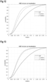
- FIG. 10 to 13 several examples of cumulative distribution functions, CDF, of localization errors with respect to corresponding ground truth positions according to the improved processing concept are shown.
- the "draft" line refers to the estimated position of the mobile device
- the 1 st iteration refers to the refined position with the first application of the weight factors
- the 2 nd iteration refers to the refined position with the second application of the weight factors.
- the CDF of Figure 10 corresponds to a scenario where the mobile device TG is moving around the room, which for example is a typical office environment.
- E threshold 0.1 has been used.
- the improvement of the confidence level of e.g. 90% is more than 0.5 m.
- Figure 12 is based on equation (18) for the weight calculation and Figure 13 is based on equation (19) for the weight calculation.
- the refined position of the mobile device TG may be determined further based on quality information for at least one of the plurality of anchor points.
- this quality information can be expressed in one or more further weight matrices that are applied to the WLS algorithm.
- the quality information for the at least one anchor point is determined from at least one of the following:
- Various embodiments of the improved processing concept can be implemented in the form of logic in software or hardware or a combination of both.
- the logic may be stored in a computer readable or machine-readable storage medium as a set of instructions adapted to direct a processor of a computer system to perform a set of steps disclosed in embodiments of the improved processing concept.
- the logic may form part of a computer program product adapted to direct an information-processing device to automatically perform a set of steps disclosed in embodiments of the improved processing concept.
Landscapes
- Engineering & Computer Science (AREA)
- Physics & Mathematics (AREA)
- General Physics & Mathematics (AREA)
- Radar, Positioning & Navigation (AREA)
- Remote Sensing (AREA)
- Signal Processing (AREA)
- Computer Networks & Wireless Communication (AREA)
- Computational Mathematics (AREA)
- Mathematical Optimization (AREA)
- Pure & Applied Mathematics (AREA)
- Mathematical Analysis (AREA)
- Data Mining & Analysis (AREA)
- Mathematical Physics (AREA)
- Theoretical Computer Science (AREA)
- Algebra (AREA)
- General Engineering & Computer Science (AREA)
- Software Systems (AREA)
- Databases & Information Systems (AREA)
- Probability & Statistics with Applications (AREA)
- Position Fixing By Use Of Radio Waves (AREA)
- Quality & Reliability (AREA)
- Electromagnetism (AREA)
Claims (15)
- Verfahren zum Bestimmen einer Position eines mobilen Geräts (TG), wobei das Verfahren umfasst:- für jeden einer Vielzahl von Ankerpunkten (1, 2, ..., 5), Empfangen jeweiliger relativer Positionsinformationen zwischen dem jeweiligen Ankerpunkt (1, 2, ..., 5) und dem mobilen Gerät (TG), so dass die empfangenen relativen Positionsinformationen für die Vielzahl von Ankerpunkten (1, 2, ..., 5) einen Satz von Positionsinformationen bilden, wobei jede relative Positionsinformation einen der folgenden Punkte enthält- eine Richtung zwischen dem jeweiligen Ankerpunkt (1, 2, ..., 5) und dem mobilen Gerät (TG);- eine Entfernung zwischen dem jeweiligen Ankerpunkt (1, 2, ..., 5) und dem mobilen Gerät (TG);- eine Richtung und eine Entfernung zwischen dem jeweiligen Ankerpunkt (1, 2, ..., 5) und dem mobilen Gerät (TG);- Bestimmen einer geschätzten Position des mobilen Geräts (TG) basierend auf dem Satz von Positionsinformationen;- Definieren eines Satzes von Loci, wobei jeder Locus des Satzes von Loci auf einer oder mehreren der relativen Positionsinformationen aus dem Satz von Positionsinformationen basiert;- Bestimmen eines Abstandswertes zwischen der geschätzten Position des mobilen Geräts (TG) und dem jeweiligen Locus für jeden Locus des Satzes von Loci;- Bestimmen eines Gewichtungsfaktors für jeden Locus des Satzes von Loci als eine Funktion der bestimmten Abstandswerte; und- Bestimmen einer verfeinerten Position des mobilen Geräts (TG) basierend auf dem Satz von Positionsinformationen und den bestimmten Gewichtungsfaktoren.
- Verfahren nach Anspruch 1, wobei- das Bestimmen der geschätzten Position des mobilen Geräts (TG) mit einem linearen Gleichungssystem durchgeführt wird, das mit einem Least-Squares-Ansatz gelöst wird; und- die Bestimmung der verfeinerten Position des mobilen Geräts (TG) mit dem linearen Gleichungssystem durchgeführt wird, das mit einem gewichteten Least-Squares-Ansatz auf der Grundlage der bestimmten Gewichtungsfaktoren gelöst wird.
- Verfahren nach Anspruch 1 oder 2, wobei die Abstandswerte als quadratische Abstände zwischen der geschätzten Position des mobilen Geräts (TG) und dem jeweiligen Locus bestimmt werden.
- Verfahren nach einem der Ansprüche 1 bis 3, wobei die Funktion, die den Gewichtungsfaktor für jeden Locus aus dem Satz von Loci als Funktion der bestimmten Abstandswerte bestimmt, monoton abnehmend oder streng abnehmend in Bezug auf den zugehörigen Abstandswert des jeweiligen Locus ist.
- Verfahren nach einem der Ansprüche 1 bis 4, wobei der Gewichtungsfaktor wi für jeden Locus des Satzes von Loci in Abhängigkeit von den ermittelten Abstandswerten definiert ist als
 - i den zugehörigen Locus bezeichnet;- M die Anzahl der Loci bezeichnet;- Ej den Abstandswert für den Locus j bezeichnet;- Ethreshold einen Abstandsschwellenwert bezeichnet; und- µ, ν Exponentenwerte mit µ, ν > 0 sind.
 - Verfahren nach einem der Ansprüche 1 bis 4, wobei der Gewichtungsfaktor wi für jeden Locus des Satzes von Loci in Abhängigkeit von den ermittelten Abstandswerten definiert ist als
 - i den zugehörigen Locus bezeichnet;- M die Anzahl der Loci bezeichnet;- Ej den Abstandswert für den Locus j bezeichnet;- Ethreshold einen Abstandsschwellenwert bezeichnet; und- ν ein Exponentenwert mit ν > 0 ist.
 - Verfahren nach einem der Ansprüche 1 bis 4, wobei der Gewichtungsfaktor wi für jeden Locus des Satzes von Loci in Abhängigkeit von den ermittelten Abstandswerten definiert ist als
 - i den zugehörigen Locus bezeichnet;- Ei den Abstandswert für den Locus i bezeichnet;- Ethreshold einen Abstandsschwellenwert bezeichnet;- whigh einen hohen Gewichtungsfaktor bezeichnet; und- wlow einen niedrigen Gewichtungsfaktor bezeichnet, der kleiner ist als der hohe Gewichtungsfaktor whigh.
 - Verfahren nach einem der Ansprüche 1 bis 7, wobei die verfeinerte Position des mobilen Geräts (TG) ferner auf der Grundlage einer Qualitätsinformation für mindestens einen der Vielzahl von Ankerpunkten (1, 2, ..., 5) bestimmt wird.
- Verfahren nach Anspruch 8, wobei die Qualitätsinformation für den mindestens einen Ankerpunkt (1, 2, ..., 5) aus mindestens einem der folgenden bestimmt wird:- einer Signalstärke, die mit der empfangenen relativen Position des mindestens einen Ankerpunkts (1, 2, ..., 5) assoziiert ist;- einer Anzahl von Antennenelementen des mindestens einen Ankerpunkts (1, 2, ..., 5);- einen Konfidenzfaktor, der mit der empfangenen relativen Position des mindestens einen Ankerpunkts (1, 2, ..., 5) assoziiert ist;- obere und/oder untere Grenzen für den Gewichtungsfaktor, der mit dem mindestens einen Ankerpunkt (1, 2, ..., 5) assoziiert ist.
- Verfahren nach einem der Ansprüche 1 bis 9, wobei das Verfahren in einer iterativen Weise durchgeführt wird, so dass- in einem ersten Iterationsschritt die geschätzte Position auf der Grundlage des Satzes von Positionsinformationen bestimmt wird; und- in jedem nachfolgenden Iterationsschritt die in einem jeweils vorangegangenen Iterationsschritt ermittelte verfeinerte Position als geschätzte Position zur Bestimmung der Abstandswerte und der Gewichtungsfaktoren verwendet wird.
- Verfahren nach einem der Ansprüche 1 bis 10, wobei eine absolute Position von jedem der Vielzahl von Ankerpunkten (1, 2, ..., 5) bekannt ist.
- Verfahren nach einem der Ansprüche 1 bis 11, wobei das Verfahren in einer Positionierungsmaschine (LPE) durchgeführt wird.
- Eine Positionierungsmaschine (LPE) zum Bestimmen einer Position eines mobilen Geräts (TG), die Positionierungsmaschine umfassend:- einen Empfänger (RX), der eingerichtet ist, um von jedem einer Vielzahl von Ankerpunkten (1, 2, ..., 5) jeweilige relative Positionsinformationen zwischen dem jeweiligen Ankerpunkt (1, 2, ..., 5) und dem mobilen Gerät (TG) zu empfangen, so dass die empfangenen relativen Positionsinformationen für die Vielzahl von Ankerpunkten (1, 2, ..., 5) einen Satz von Positionsinformationen bilden, wobei jede relative Positionsinformation einen der folgenden Punkte enthält- eine Richtung zwischen dem jeweiligen Ankerpunkt (1, 2, ..., 5) und dem mobilen Gerät (TG);- eine Entfernung zwischen dem jeweiligen Ankerpunkt (1, 2, ..., 5) und dem mobilen Gerät (TG);- eine Richtung und eine Entfernung zwischen dem jeweiligen Ankerpunkt (1, 2, ..., 5) und dem mobilen Gerät (TG); und- eine Verarbeitungseinheit (PROC), die eingerichtet ist zum:- Bestimmen einer geschätzten Position des mobilen Geräts (TG) basierend auf dem Satz von Positionsinformationen;- Definieren eines Satzes von Loci, wobei jeder Locus des Satzes von Loci auf einer oder mehreren der relativen Positionsinformationen aus dem Satz von Positionsinformationen basiert;- Bestimmen eines Abstandswertes zwischen der geschätzten Position des mobilen Geräts (TG) und dem jeweiligen Locus für jeden Locus des Satzes von Loci;- Bestimmen eines Gewichtungsfaktors für jeden Locus des Satzes von Loci als eine Funktion der bestimmten Abstandswerte; und- Bestimmen einer verfeinerten Position des mobilen Geräts (TG) basierend auf dem Satz von Positionsinformationen und den bestimmten Gewichtungsfaktoren.
- Computerprogrammprodukt umfassend Anweisungen, die, wenn sie auf einem Prozessor ausgeführt werden, den Prozessor veranlassen, das Verfahren nach einem der Ansprüche 1 bis 12 durchzuführen.
- Computerlesbares Speichermedium, das das Computerprogrammprodukt nach Anspruch 14 enthält.
Priority Applications (3)
| Application Number | Priority Date | Filing Date | Title |
|---|---|---|---|
| EP21197751.7A EP4152039B1 (de) | 2021-09-20 | 2021-09-20 | Verfahren und positionierungs-engine zur bestimmung einer position einer mobilen vorrichtung |
| CN202211132830.0A CN115835374A (zh) | 2021-09-20 | 2022-09-16 | 确定移动设备的位置的方法和定位引擎 |
| US17/947,754 US12235375B2 (en) | 2021-09-20 | 2022-09-19 | Method and positioning engine for determining a position of a mobile device |
Applications Claiming Priority (1)
| Application Number | Priority Date | Filing Date | Title |
|---|---|---|---|
| EP21197751.7A EP4152039B1 (de) | 2021-09-20 | 2021-09-20 | Verfahren und positionierungs-engine zur bestimmung einer position einer mobilen vorrichtung |
Publications (2)
| Publication Number | Publication Date |
|---|---|
| EP4152039A1 EP4152039A1 (de) | 2023-03-22 |
| EP4152039B1 true EP4152039B1 (de) | 2024-05-22 |
Family
ID=77864390
Family Applications (1)
| Application Number | Title | Priority Date | Filing Date |
|---|---|---|---|
| EP21197751.7A Active EP4152039B1 (de) | 2021-09-20 | 2021-09-20 | Verfahren und positionierungs-engine zur bestimmung einer position einer mobilen vorrichtung |
Country Status (3)
| Country | Link |
|---|---|
| US (1) | US12235375B2 (de) |
| EP (1) | EP4152039B1 (de) |
| CN (1) | CN115835374A (de) |
Families Citing this family (1)
| Publication number | Priority date | Publication date | Assignee | Title |
|---|---|---|---|---|
| US12099132B2 (en) * | 2022-04-22 | 2024-09-24 | Auki Labs Ag | Using reference measurements to reduce geospatial uncertainty |
Family Cites Families (6)
| Publication number | Priority date | Publication date | Assignee | Title |
|---|---|---|---|---|
| US8406785B2 (en) * | 2009-08-18 | 2013-03-26 | Skyhook Wireless, Inc. | Method and system for estimating range of mobile device to wireless installation |
| US8149162B1 (en) * | 2009-10-12 | 2012-04-03 | Exelis Inc. | Methods and apparatus for N-lateration with noisy data measurements |
| US10506542B2 (en) * | 2010-09-03 | 2019-12-10 | Qualcomm Incorporated | Methods and apparatus for using mobile devices as location anchor points |
| GB2551347B (en) * | 2016-06-13 | 2020-04-15 | Toshiba Kk | Indoor localisation using received signal quality weights |
| EP3477329B1 (de) * | 2017-10-26 | 2021-09-29 | SAFEmine AG | System mit globaler positionierung und hf-flugzeitmessung zur überwachung der sicherheit an einem ort |
| US11595938B2 (en) * | 2021-02-01 | 2023-02-28 | Qualcomm Incorporated | Positioning based on relative positions of base stations and/or user equipments |
-
2021
- 2021-09-20 EP EP21197751.7A patent/EP4152039B1/de active Active
-
2022
- 2022-09-16 CN CN202211132830.0A patent/CN115835374A/zh active Pending
- 2022-09-19 US US17/947,754 patent/US12235375B2/en active Active
Also Published As
| Publication number | Publication date |
|---|---|
| US20230091448A1 (en) | 2023-03-23 |
| US12235375B2 (en) | 2025-02-25 |
| CN115835374A (zh) | 2023-03-21 |
| EP4152039A1 (de) | 2023-03-22 |
Similar Documents
| Publication | Publication Date | Title |
|---|---|---|
| CN102273081B (zh) | 使用广义误差分布来进行位置估计的方法 | |
| US8478292B2 (en) | Wireless localization method based on an efficient multilateration algorithm over a wireless sensor network and a recording medium in which a program for the method is recorded | |
| Wang et al. | TOA-based NLOS error mitigation algorithm for 3D indoor localization | |
| US8188919B2 (en) | Globally-convergent geo-location algorithm | |
| US9660740B2 (en) | Signal strength distribution establishing method and wireless positioning system | |
| CN102811419B (zh) | 一种基于迭代的最小二乘定位方法 | |
| CN113534130B (zh) | 基于视线角度的多站雷达多目标数据关联方法 | |
| JP2001318136A (ja) | 重み付きリッジ回帰を使用する位置決定方法 | |
| CN109901106A (zh) | 一种tdoa/aoa混合定位方法 | |
| Wigren | LTE fingerprinting localization with altitude | |
| Zaeemzadeh et al. | Robust target localization based on squared range iterative reweighted least squares | |
| EP4152039B1 (de) | Verfahren und positionierungs-engine zur bestimmung einer position einer mobilen vorrichtung | |
| Piwowarczyk et al. | Analysis of the influence of radio beacon placement on the accuracy of indoor positioning system | |
| Wu et al. | Optimal beacon deployment for positioning in cluttered indoor environments | |
| Eltohamy et al. | Optimum access-point constellation for indoor time difference of arrival positioning | |
| RU2638177C1 (ru) | Способ определения координат источника радиоизлучений с борта летательного аппарата по двум азимутальным пеленгам | |
| EP4191271B1 (de) | Verfahren zur erkennung von anomalien in einem positionierungssystem und positionierungsmaschine für ein positionierungssystem | |
| Gu et al. | The effect of ground truth accuracy on the evaluation of localization systems | |
| Verma et al. | Doa estimation for autonomous systems in complex propagation environments | |
| EP4123332A1 (de) | Verfahren zum schätzen eines standorts von mindestens einem mobilen netzwerkknoten und entsprechendes netzwerk | |
| CN105101403B (zh) | 一种基于应急蜂窝通信网络的精确定位方法 | |
| CN109255150B (zh) | 基于双向次序关联的多天线到达角数据关联方法 | |
| Landolsi et al. | TOAI/AOA/RSS maximum likelihood data fusion for efficient localization in wireless networks | |
| CN114630416B (zh) | 用于对移动终端进行定位的方法、装置及设备 | |
| Zhu et al. | A novel angle of arrival (AOA) positioning algorithm aided by location reliability prior information |
Legal Events
| Date | Code | Title | Description |
|---|---|---|---|
| PUAI | Public reference made under article 153(3) epc to a published international application that has entered the european phase |
Free format text: ORIGINAL CODE: 0009012 |
|
| STAA | Information on the status of an ep patent application or granted ep patent |
Free format text: STATUS: THE APPLICATION HAS BEEN PUBLISHED |
|
| AK | Designated contracting states |
Kind code of ref document: A1 Designated state(s): AL AT BE BG CH CY CZ DE DK EE ES FI FR GB GR HR HU IE IS IT LI LT LU LV MC MK MT NL NO PL PT RO RS SE SI SK SM TR |
|
| STAA | Information on the status of an ep patent application or granted ep patent |
Free format text: STATUS: REQUEST FOR EXAMINATION WAS MADE |
|
| 17P | Request for examination filed |
Effective date: 20230830 |
|
| RBV | Designated contracting states (corrected) |
Designated state(s): AL AT BE BG CH CY CZ DE DK EE ES FI FR GB GR HR HU IE IS IT LI LT LU LV MC MK MT NL NO PL PT RO RS SE SI SK SM TR |
|
| GRAP | Despatch of communication of intention to grant a patent |
Free format text: ORIGINAL CODE: EPIDOSNIGR1 |
|
| STAA | Information on the status of an ep patent application or granted ep patent |
Free format text: STATUS: GRANT OF PATENT IS INTENDED |
|
| INTG | Intention to grant announced |
Effective date: 20231218 |
|
| GRAS | Grant fee paid |
Free format text: ORIGINAL CODE: EPIDOSNIGR3 |
|
| GRAA | (expected) grant |
Free format text: ORIGINAL CODE: 0009210 |
|
| STAA | Information on the status of an ep patent application or granted ep patent |
Free format text: STATUS: THE PATENT HAS BEEN GRANTED |
|
| AK | Designated contracting states |
Kind code of ref document: B1 Designated state(s): AL AT BE BG CH CY CZ DE DK EE ES FI FR GB GR HR HU IE IS IT LI LT LU LV MC MK MT NL NO PL PT RO RS SE SI SK SM TR |
|
| REG | Reference to a national code |
Ref country code: GB Ref legal event code: FG4D |
|
| REG | Reference to a national code |
Ref country code: CH Ref legal event code: EP |
|
| REG | Reference to a national code |
Ref country code: DE Ref legal event code: R096 Ref document number: 602021013507 Country of ref document: DE |
|
| REG | Reference to a national code |
Ref country code: IE Ref legal event code: FG4D |
|
| REG | Reference to a national code |
Ref country code: LT Ref legal event code: MG9D |
|
| REG | Reference to a national code |
Ref country code: NL Ref legal event code: MP Effective date: 20240522 |
|
| PG25 | Lapsed in a contracting state [announced via postgrant information from national office to epo] |
Ref country code: IS Free format text: LAPSE BECAUSE OF FAILURE TO SUBMIT A TRANSLATION OF THE DESCRIPTION OR TO PAY THE FEE WITHIN THE PRESCRIBED TIME-LIMIT Effective date: 20240922 |
|
| PG25 | Lapsed in a contracting state [announced via postgrant information from national office to epo] |
Ref country code: BG Free format text: LAPSE BECAUSE OF FAILURE TO SUBMIT A TRANSLATION OF THE DESCRIPTION OR TO PAY THE FEE WITHIN THE PRESCRIBED TIME-LIMIT Effective date: 20240522 |
|
| PG25 | Lapsed in a contracting state [announced via postgrant information from national office to epo] |
Ref country code: HR Free format text: LAPSE BECAUSE OF FAILURE TO SUBMIT A TRANSLATION OF THE DESCRIPTION OR TO PAY THE FEE WITHIN THE PRESCRIBED TIME-LIMIT Effective date: 20240522 Ref country code: FI Free format text: LAPSE BECAUSE OF FAILURE TO SUBMIT A TRANSLATION OF THE DESCRIPTION OR TO PAY THE FEE WITHIN THE PRESCRIBED TIME-LIMIT Effective date: 20240522 |
|
| PG25 | Lapsed in a contracting state [announced via postgrant information from national office to epo] |
Ref country code: GR Free format text: LAPSE BECAUSE OF FAILURE TO SUBMIT A TRANSLATION OF THE DESCRIPTION OR TO PAY THE FEE WITHIN THE PRESCRIBED TIME-LIMIT Effective date: 20240823 |
|
| PG25 | Lapsed in a contracting state [announced via postgrant information from national office to epo] |
Ref country code: PT Free format text: LAPSE BECAUSE OF FAILURE TO SUBMIT A TRANSLATION OF THE DESCRIPTION OR TO PAY THE FEE WITHIN THE PRESCRIBED TIME-LIMIT Effective date: 20240923 |
|
| REG | Reference to a national code |
Ref country code: AT Ref legal event code: MK05 Ref document number: 1689199 Country of ref document: AT Kind code of ref document: T Effective date: 20240522 |
|
| PG25 | Lapsed in a contracting state [announced via postgrant information from national office to epo] |
Ref country code: NL Free format text: LAPSE BECAUSE OF FAILURE TO SUBMIT A TRANSLATION OF THE DESCRIPTION OR TO PAY THE FEE WITHIN THE PRESCRIBED TIME-LIMIT Effective date: 20240522 |
|
| PG25 | Lapsed in a contracting state [announced via postgrant information from national office to epo] |
Ref country code: ES Free format text: LAPSE BECAUSE OF FAILURE TO SUBMIT A TRANSLATION OF THE DESCRIPTION OR TO PAY THE FEE WITHIN THE PRESCRIBED TIME-LIMIT Effective date: 20240522 |
|
| PG25 | Lapsed in a contracting state [announced via postgrant information from national office to epo] |
Ref country code: AT Free format text: LAPSE BECAUSE OF FAILURE TO SUBMIT A TRANSLATION OF THE DESCRIPTION OR TO PAY THE FEE WITHIN THE PRESCRIBED TIME-LIMIT Effective date: 20240522 |
|
| PG25 | Lapsed in a contracting state [announced via postgrant information from national office to epo] |
Ref country code: PL Free format text: LAPSE BECAUSE OF FAILURE TO SUBMIT A TRANSLATION OF THE DESCRIPTION OR TO PAY THE FEE WITHIN THE PRESCRIBED TIME-LIMIT Effective date: 20240522 |
|
| PG25 | Lapsed in a contracting state [announced via postgrant information from national office to epo] |
Ref country code: LV Free format text: LAPSE BECAUSE OF FAILURE TO SUBMIT A TRANSLATION OF THE DESCRIPTION OR TO PAY THE FEE WITHIN THE PRESCRIBED TIME-LIMIT Effective date: 20240522 |
|
| PG25 | Lapsed in a contracting state [announced via postgrant information from national office to epo] |
Ref country code: PT Free format text: LAPSE BECAUSE OF FAILURE TO SUBMIT A TRANSLATION OF THE DESCRIPTION OR TO PAY THE FEE WITHIN THE PRESCRIBED TIME-LIMIT Effective date: 20240923 Ref country code: PL Free format text: LAPSE BECAUSE OF FAILURE TO SUBMIT A TRANSLATION OF THE DESCRIPTION OR TO PAY THE FEE WITHIN THE PRESCRIBED TIME-LIMIT Effective date: 20240522 Ref country code: NO Free format text: LAPSE BECAUSE OF FAILURE TO SUBMIT A TRANSLATION OF THE DESCRIPTION OR TO PAY THE FEE WITHIN THE PRESCRIBED TIME-LIMIT Effective date: 20240822 Ref country code: NL Free format text: LAPSE BECAUSE OF FAILURE TO SUBMIT A TRANSLATION OF THE DESCRIPTION OR TO PAY THE FEE WITHIN THE PRESCRIBED TIME-LIMIT Effective date: 20240522 Ref country code: LV Free format text: LAPSE BECAUSE OF FAILURE TO SUBMIT A TRANSLATION OF THE DESCRIPTION OR TO PAY THE FEE WITHIN THE PRESCRIBED TIME-LIMIT Effective date: 20240522 Ref country code: IS Free format text: LAPSE BECAUSE OF FAILURE TO SUBMIT A TRANSLATION OF THE DESCRIPTION OR TO PAY THE FEE WITHIN THE PRESCRIBED TIME-LIMIT Effective date: 20240922 Ref country code: HR Free format text: LAPSE BECAUSE OF FAILURE TO SUBMIT A TRANSLATION OF THE DESCRIPTION OR TO PAY THE FEE WITHIN THE PRESCRIBED TIME-LIMIT Effective date: 20240522 Ref country code: GR Free format text: LAPSE BECAUSE OF FAILURE TO SUBMIT A TRANSLATION OF THE DESCRIPTION OR TO PAY THE FEE WITHIN THE PRESCRIBED TIME-LIMIT Effective date: 20240823 Ref country code: FI Free format text: LAPSE BECAUSE OF FAILURE TO SUBMIT A TRANSLATION OF THE DESCRIPTION OR TO PAY THE FEE WITHIN THE PRESCRIBED TIME-LIMIT Effective date: 20240522 Ref country code: ES Free format text: LAPSE BECAUSE OF FAILURE TO SUBMIT A TRANSLATION OF THE DESCRIPTION OR TO PAY THE FEE WITHIN THE PRESCRIBED TIME-LIMIT Effective date: 20240522 Ref country code: BG Free format text: LAPSE BECAUSE OF FAILURE TO SUBMIT A TRANSLATION OF THE DESCRIPTION OR TO PAY THE FEE WITHIN THE PRESCRIBED TIME-LIMIT Effective date: 20240522 Ref country code: AT Free format text: LAPSE BECAUSE OF FAILURE TO SUBMIT A TRANSLATION OF THE DESCRIPTION OR TO PAY THE FEE WITHIN THE PRESCRIBED TIME-LIMIT Effective date: 20240522 Ref country code: RS Free format text: LAPSE BECAUSE OF FAILURE TO SUBMIT A TRANSLATION OF THE DESCRIPTION OR TO PAY THE FEE WITHIN THE PRESCRIBED TIME-LIMIT Effective date: 20240822 |
|
| PG25 | Lapsed in a contracting state [announced via postgrant information from national office to epo] |
Ref country code: DK Free format text: LAPSE BECAUSE OF FAILURE TO SUBMIT A TRANSLATION OF THE DESCRIPTION OR TO PAY THE FEE WITHIN THE PRESCRIBED TIME-LIMIT Effective date: 20240522 |
|
| PG25 | Lapsed in a contracting state [announced via postgrant information from national office to epo] |
Ref country code: EE Free format text: LAPSE BECAUSE OF FAILURE TO SUBMIT A TRANSLATION OF THE DESCRIPTION OR TO PAY THE FEE WITHIN THE PRESCRIBED TIME-LIMIT Effective date: 20240522 |
|
| PG25 | Lapsed in a contracting state [announced via postgrant information from national office to epo] |
Ref country code: CZ Free format text: LAPSE BECAUSE OF FAILURE TO SUBMIT A TRANSLATION OF THE DESCRIPTION OR TO PAY THE FEE WITHIN THE PRESCRIBED TIME-LIMIT Effective date: 20240522 |
|
| PG25 | Lapsed in a contracting state [announced via postgrant information from national office to epo] |
Ref country code: SK Free format text: LAPSE BECAUSE OF FAILURE TO SUBMIT A TRANSLATION OF THE DESCRIPTION OR TO PAY THE FEE WITHIN THE PRESCRIBED TIME-LIMIT Effective date: 20240522 Ref country code: RO Free format text: LAPSE BECAUSE OF FAILURE TO SUBMIT A TRANSLATION OF THE DESCRIPTION OR TO PAY THE FEE WITHIN THE PRESCRIBED TIME-LIMIT Effective date: 20240522 |
|
| PG25 | Lapsed in a contracting state [announced via postgrant information from national office to epo] |
Ref country code: SK Free format text: LAPSE BECAUSE OF FAILURE TO SUBMIT A TRANSLATION OF THE DESCRIPTION OR TO PAY THE FEE WITHIN THE PRESCRIBED TIME-LIMIT Effective date: 20240522 Ref country code: RO Free format text: LAPSE BECAUSE OF FAILURE TO SUBMIT A TRANSLATION OF THE DESCRIPTION OR TO PAY THE FEE WITHIN THE PRESCRIBED TIME-LIMIT Effective date: 20240522 Ref country code: EE Free format text: LAPSE BECAUSE OF FAILURE TO SUBMIT A TRANSLATION OF THE DESCRIPTION OR TO PAY THE FEE WITHIN THE PRESCRIBED TIME-LIMIT Effective date: 20240522 Ref country code: DK Free format text: LAPSE BECAUSE OF FAILURE TO SUBMIT A TRANSLATION OF THE DESCRIPTION OR TO PAY THE FEE WITHIN THE PRESCRIBED TIME-LIMIT Effective date: 20240522 Ref country code: CZ Free format text: LAPSE BECAUSE OF FAILURE TO SUBMIT A TRANSLATION OF THE DESCRIPTION OR TO PAY THE FEE WITHIN THE PRESCRIBED TIME-LIMIT Effective date: 20240522 |
|
| PG25 | Lapsed in a contracting state [announced via postgrant information from national office to epo] |
Ref country code: IT Free format text: LAPSE BECAUSE OF FAILURE TO SUBMIT A TRANSLATION OF THE DESCRIPTION OR TO PAY THE FEE WITHIN THE PRESCRIBED TIME-LIMIT Effective date: 20240522 |
|
| REG | Reference to a national code |
Ref country code: DE Ref legal event code: R097 Ref document number: 602021013507 Country of ref document: DE |
|
| PLBE | No opposition filed within time limit |
Free format text: ORIGINAL CODE: 0009261 |
|
| STAA | Information on the status of an ep patent application or granted ep patent |
Free format text: STATUS: NO OPPOSITION FILED WITHIN TIME LIMIT |
|
| PG25 | Lapsed in a contracting state [announced via postgrant information from national office to epo] |
Ref country code: SI Free format text: LAPSE BECAUSE OF FAILURE TO SUBMIT A TRANSLATION OF THE DESCRIPTION OR TO PAY THE FEE WITHIN THE PRESCRIBED TIME-LIMIT Effective date: 20240522 Ref country code: MC Free format text: LAPSE BECAUSE OF FAILURE TO SUBMIT A TRANSLATION OF THE DESCRIPTION OR TO PAY THE FEE WITHIN THE PRESCRIBED TIME-LIMIT Effective date: 20240522 |
|
| 26N | No opposition filed |
Effective date: 20250225 |
|
| REG | Reference to a national code |
Ref country code: CH Ref legal event code: PL |
|
| PG25 | Lapsed in a contracting state [announced via postgrant information from national office to epo] |
Ref country code: LU Free format text: LAPSE BECAUSE OF NON-PAYMENT OF DUE FEES Effective date: 20240920 |
|
| REG | Reference to a national code |
Ref country code: BE Ref legal event code: MM Effective date: 20240930 |
|
| PG25 | Lapsed in a contracting state [announced via postgrant information from national office to epo] |
Ref country code: BE Free format text: LAPSE BECAUSE OF NON-PAYMENT OF DUE FEES Effective date: 20240930 |
|
| PG25 | Lapsed in a contracting state [announced via postgrant information from national office to epo] |
Ref country code: CH Free format text: LAPSE BECAUSE OF NON-PAYMENT OF DUE FEES Effective date: 20240930 |
|
| PG25 | Lapsed in a contracting state [announced via postgrant information from national office to epo] |
Ref country code: IE Free format text: LAPSE BECAUSE OF NON-PAYMENT OF DUE FEES Effective date: 20240920 |
|
| PG25 | Lapsed in a contracting state [announced via postgrant information from national office to epo] |
Ref country code: SE Free format text: LAPSE BECAUSE OF FAILURE TO SUBMIT A TRANSLATION OF THE DESCRIPTION OR TO PAY THE FEE WITHIN THE PRESCRIBED TIME-LIMIT Effective date: 20240522 |
|
| PGFP | Annual fee paid to national office [announced via postgrant information from national office to epo] |
Ref country code: DE Payment date: 20250919 Year of fee payment: 5 |
|
| PGFP | Annual fee paid to national office [announced via postgrant information from national office to epo] |
Ref country code: GB Payment date: 20250919 Year of fee payment: 5 |
|
| PGFP | Annual fee paid to national office [announced via postgrant information from national office to epo] |
Ref country code: FR Payment date: 20250922 Year of fee payment: 5 |
|
| PG25 | Lapsed in a contracting state [announced via postgrant information from national office to epo] |
Ref country code: SM Free format text: LAPSE BECAUSE OF FAILURE TO SUBMIT A TRANSLATION OF THE DESCRIPTION OR TO PAY THE FEE WITHIN THE PRESCRIBED TIME-LIMIT; INVALID AB INITIO Effective date: 20210920 |
|
| PG25 | Lapsed in a contracting state [announced via postgrant information from national office to epo] |
Ref country code: CY Free format text: LAPSE BECAUSE OF FAILURE TO SUBMIT A TRANSLATION OF THE DESCRIPTION OR TO PAY THE FEE WITHIN THE PRESCRIBED TIME-LIMIT; INVALID AB INITIO Effective date: 20210920 |
|
| PG25 | Lapsed in a contracting state [announced via postgrant information from national office to epo] |
Ref country code: HU Free format text: LAPSE BECAUSE OF FAILURE TO SUBMIT A TRANSLATION OF THE DESCRIPTION OR TO PAY THE FEE WITHIN THE PRESCRIBED TIME-LIMIT; INVALID AB INITIO Effective date: 20210920 |