EP3576438A1 - Verfahren zur verbesserung der sicherheit zum navigieren eines fahrzeugs durch die bereitstellung von echtzeitnavigationsdaten für das fahrzeug über ein mobilkommunikationsnetz, system zur verbesserung der sicherheit zum navigieren eines fahrzeugs durch die bereitstellung von echtzeitnavigationsdaten für das fahrzeug über ein mobilkommunikationsnetz, programm und computerprogrammprodukt - Google Patents
Verfahren zur verbesserung der sicherheit zum navigieren eines fahrzeugs durch die bereitstellung von echtzeitnavigationsdaten für das fahrzeug über ein mobilkommunikationsnetz, system zur verbesserung der sicherheit zum navigieren eines fahrzeugs durch die bereitstellung von echtzeitnavigationsdaten für das fahrzeug über ein mobilkommunikationsnetz, programm und computerprogrammprodukt Download PDFInfo
- Publication number
- EP3576438A1 EP3576438A1 EP19181979.6A EP19181979A EP3576438A1 EP 3576438 A1 EP3576438 A1 EP 3576438A1 EP 19181979 A EP19181979 A EP 19181979A EP 3576438 A1 EP3576438 A1 EP 3576438A1
- Authority
- EP
- European Patent Office
- Prior art keywords
- vehicle
- remote sensing
- data
- real
- mobile communication
- Prior art date
- Legal status (The legal status is an assumption and is not a legal conclusion. Google has not performed a legal analysis and makes no representation as to the accuracy of the status listed.)
- Granted
Links
- 238000010295 mobile communication Methods 0.000 title claims abstract description 157
- 238000000034 method Methods 0.000 title claims abstract description 74
- 230000002708 enhancing effect Effects 0.000 title claims abstract description 36
- 238000004590 computer program Methods 0.000 title claims description 14
- 230000001965 increasing effect Effects 0.000 claims abstract description 10
- 230000001419 dependent effect Effects 0.000 claims description 4
- 238000001514 detection method Methods 0.000 claims description 4
- 230000009467 reduction Effects 0.000 claims description 4
- 238000009434 installation Methods 0.000 description 8
- 238000012423 maintenance Methods 0.000 description 7
- RZVHIXYEVGDQDX-UHFFFAOYSA-N 9,10-anthraquinone Chemical compound C1=CC=C2C(=O)C3=CC=CC=C3C(=O)C2=C1 RZVHIXYEVGDQDX-UHFFFAOYSA-N 0.000 description 6
- 238000005259 measurement Methods 0.000 description 4
- 230000007246 mechanism Effects 0.000 description 3
- 238000012986 modification Methods 0.000 description 3
- 230000004048 modification Effects 0.000 description 3
- 230000011664 signaling Effects 0.000 description 3
- 230000005540 biological transmission Effects 0.000 description 2
- 235000000332 black box Nutrition 0.000 description 2
- 238000004364 calculation method Methods 0.000 description 2
- 230000001413 cellular effect Effects 0.000 description 2
- 230000008859 change Effects 0.000 description 2
- 238000004891 communication Methods 0.000 description 2
- 231100001261 hazardous Toxicity 0.000 description 2
- 230000001953 sensory effect Effects 0.000 description 2
- 230000000007 visual effect Effects 0.000 description 2
- XLYOFNOQVPJJNP-UHFFFAOYSA-N water Substances O XLYOFNOQVPJJNP-UHFFFAOYSA-N 0.000 description 2
- 230000003213 activating effect Effects 0.000 description 1
- 230000004913 activation Effects 0.000 description 1
- 230000004075 alteration Effects 0.000 description 1
- 239000010426 asphalt Substances 0.000 description 1
- 230000003247 decreasing effect Effects 0.000 description 1
- 238000013461 design Methods 0.000 description 1
- 238000005265 energy consumption Methods 0.000 description 1
- 238000005516 engineering process Methods 0.000 description 1
- 238000007667 floating Methods 0.000 description 1
- 238000003384 imaging method Methods 0.000 description 1
- 230000008676 import Effects 0.000 description 1
- 230000004807 localization Effects 0.000 description 1
- 230000004297 night vision Effects 0.000 description 1
- 230000003287 optical effect Effects 0.000 description 1
- 230000008520 organization Effects 0.000 description 1
- 230000002265 prevention Effects 0.000 description 1
- 238000012546 transfer Methods 0.000 description 1
Images


Classifications
-
- H—ELECTRICITY
- H04—ELECTRIC COMMUNICATION TECHNIQUE
- H04W—WIRELESS COMMUNICATION NETWORKS
- H04W4/00—Services specially adapted for wireless communication networks; Facilities therefor
- H04W4/02—Services making use of location information
- H04W4/024—Guidance services
-
- G—PHYSICS
- G01—MEASURING; TESTING
- G01S—RADIO DIRECTION-FINDING; RADIO NAVIGATION; DETERMINING DISTANCE OR VELOCITY BY USE OF RADIO WAVES; LOCATING OR PRESENCE-DETECTING BY USE OF THE REFLECTION OR RERADIATION OF RADIO WAVES; ANALOGOUS ARRANGEMENTS USING OTHER WAVES
- G01S19/00—Satellite radio beacon positioning systems; Determining position, velocity or attitude using signals transmitted by such systems
- G01S19/38—Determining a navigation solution using signals transmitted by a satellite radio beacon positioning system
- G01S19/39—Determining a navigation solution using signals transmitted by a satellite radio beacon positioning system the satellite radio beacon positioning system transmitting time-stamped messages, e.g. GPS [Global Positioning System], GLONASS [Global Orbiting Navigation Satellite System] or GALILEO
- G01S19/42—Determining position
- G01S19/48—Determining position by combining or switching between position solutions derived from the satellite radio beacon positioning system and position solutions derived from a further system
-
- G—PHYSICS
- G01—MEASURING; TESTING
- G01S—RADIO DIRECTION-FINDING; RADIO NAVIGATION; DETERMINING DISTANCE OR VELOCITY BY USE OF RADIO WAVES; LOCATING OR PRESENCE-DETECTING BY USE OF THE REFLECTION OR RERADIATION OF RADIO WAVES; ANALOGOUS ARRANGEMENTS USING OTHER WAVES
- G01S5/00—Position-fixing by co-ordinating two or more direction or position line determinations; Position-fixing by co-ordinating two or more distance determinations
- G01S5/0009—Transmission of position information to remote stations
-
- H—ELECTRICITY
- H04—ELECTRIC COMMUNICATION TECHNIQUE
- H04W—WIRELESS COMMUNICATION NETWORKS
- H04W4/00—Services specially adapted for wireless communication networks; Facilities therefor
- H04W4/02—Services making use of location information
- H04W4/029—Location-based management or tracking services
-
- H—ELECTRICITY
- H04—ELECTRIC COMMUNICATION TECHNIQUE
- H04W—WIRELESS COMMUNICATION NETWORKS
- H04W4/00—Services specially adapted for wireless communication networks; Facilities therefor
- H04W4/30—Services specially adapted for particular environments, situations or purposes
- H04W4/40—Services specially adapted for particular environments, situations or purposes for vehicles, e.g. vehicle-to-pedestrians [V2P]
- H04W4/44—Services specially adapted for particular environments, situations or purposes for vehicles, e.g. vehicle-to-pedestrians [V2P] for communication between vehicles and infrastructures, e.g. vehicle-to-cloud [V2C] or vehicle-to-home [V2H]
-
- H—ELECTRICITY
- H04—ELECTRIC COMMUNICATION TECHNIQUE
- H04W—WIRELESS COMMUNICATION NETWORKS
- H04W4/00—Services specially adapted for wireless communication networks; Facilities therefor
- H04W4/90—Services for handling of emergency or hazardous situations, e.g. earthquake and tsunami warning systems [ETWS]
Definitions
- the present invention relates a method for enhancing the security of navigating a vehicle by providing real-time navigation data to the vehicle via a mobile communication network, wherein the mobile communication network comprises a radio access network, the radio access network comprising a coverage region, wherein at least one remote sensing system is connected to the mobile communication network, the at least one remote sensing system comprising a remote sensing system, the remote sensing system comprising a remote sensing region.
- the present invention relates to a system for enhancing the security of navigating a vehicle by providing real-time navigation data to the vehicle via a mobile communication network
- the system comprises the mobile communication network and at least one remote sensing system
- the mobile communication network comprises a radio access network, the radio access network comprising a coverage region
- the at least one remote sensing system is connected to the mobile communication network, the at least one remote sensing system comprising a remote sensing system, the remote sensing system comprising a remote sensing region.
- the present invention relates to a program and to a computer program product for enhancing the security of navigating a vehicle by providing real-time navigation data to the vehicle via a mobile communication network.
- vehicles have relatively constrained abilities with regard to travelling under hazardous conditions while travelling in or on at least one of the mediums air, land and water.
- Such vehicles may include aircrafts which make use of the air medium and may include all types of vehicles (and ships) that are either floating through air or flying using rotor blades and/or wings through the air.
- Land vehicles may comprise an air cushion, a chain track or wheels which enables them to be propelled over the surface (of e. g. a road).
- Watercrafts may include motor boats, speed boats, sailing boats, jolly-boats and all other types of wind-driven nautical vessel (e.g. a trimaran).
- hybrid vehicles exist. Aircrafts may typically fully depend on their instrumentation and a flight control system. Regarding motor driven land vehicles, the digitalisation of their equipments is increasing, but is typically restricted to navigational features, entertainment features and overviews on the vehicle-parameter features.
- External information systems may be used to inform vehicle users via a radio station that a traffic jam has occurred just around the corner of the street the users are driving.
- Navigational and information systems may provide similar functionalities on situations within a certain surrounding. However, neither of the aforementioned systems would be considered near-time information in case traffic jams were already resolved while still being announced on the radio.
- Watercrafts are typically equipped with sea maps and navigational equipment including a compass and tilt-meter, which - however- may be considered unsuitable to increase safety, for example, under relatively poor visual conditions.
- radar images are provided within the vehicle using on-board radar systems.
- aircrafts being equipped with a radar system are primarily designed for commercial or military use or are mostly found in higher and more expensive privately owned entities.
- a relatively large number of worldwide existing aircrafts may be either unsuitable for a normal radar installation in, e. g., a nose cone or lack the engine power to compensate any losses in the load capacity by the weight of appropriate equipment.
- such vehicles may include (mainly single) engine-propelled aircrafts and certain sorts of helicopters.
- Radar systems and/or recorder systems as well as both a Flight Data Recorder (FDR) and Voice Data Recorder (VDR) are installed in vehicles for commercial use, for example aircrafts or cargo planes.
- FDR Flight Data Recorder
- VDR Voice Data Recorder
- Most military aircrafts may be equipped with a radar system and include the before mentioned Flight Data Recorder (FDR) and Voice Data Recorder (VDR).
- vehicles with on-board radar systems may be considered unsuitable in most cases (e.g. for private use), especially due to a rather expensive radar system and/or rather difficult and awkward installation of the radar system, especially in already built entities.
- energy consumption and/or the weight of such vehicles may be considered relatively high due to an on-board radar system.
- the vehicle may be left without radar images under hazardous situations in which objects remain undetected.
- real-time hazard prevention mechanisms may fail or become ineffective.
- the object of the present invention is achieved by a method for enhancing the security of navigating a vehicle by providing real-time navigation data to the vehicle via a mobile communication network, wherein the mobile communication network comprises a radio access network, the radio access network comprising a coverage region, wherein at least one remote sensing system is connected to the mobile communication network, the at least one remote sensing system comprising a remote sensing system, the remote sensing system comprising a remote sensing region, wherein the remote sensing region at least partially overlaps with the coverage region, wherein the mobile communication network comprises a server entity, wherein the method comprises the following steps:
- the invention is based on the use of a mobile communication network being configured to transmit - in at-least a near real-time modus - such data (i.e. navigation data including information and images) from a remote sensing system (e.g. a radar facility) to the vehicle (especially a user in the vehicle, which is at least one of an aircraft, watercraft and land vehicle).
- a mobile communication network being configured to transmit - in at-least a near real-time modus - such data (i.e. navigation data including information and images) from a remote sensing system (e.g. a radar facility) to the vehicle (especially a user in the vehicle, which is at least one of an aircraft, watercraft and land vehicle).
- real-time or near real-time relates to a time interval in dependence of, e. g., provided resolution, vehicle speed value (or vehicle speed values), travelling path (or traveling paths), proximity, weather conditions in the region of travelling, etc. to also other vehicles and is preferably in the range of preferably less than one minute, or even less than that.
- a vehicle is at least one of an aircraft, watercraft and land vehicle, being preferably adapted to make journeys under clear or relatively good (surrounding) conditions.
- the vehicle is a helicopter, a hot air balloon or sailing boat.
- a relatively small vehicle e. g.
- a glider plane a in general smaller type of helicopter or a hot air balloon
- a remote sensing system e.g. a radar system
- the generation of energy is typically impossible without special provisions.
- a vehicle - which lacks an on-board sensing system or which is unsuitable for carrying an on-board sensing system - with the enhanced navigational data (e.g. including real-time radar images), but thereby avoiding any adjustments or modifications in its design, avoiding an increase of weight and cost due an on-board sensing system, avoiding further modifications of, as an example, a conventional cockpit (which would need an relatively expensive enhancement) and/or avoiding modifications to the fuselage, the rudder and/or the wings.
- the aforementioned advantages and features being exemplarily described for one type of a vehicle (e.g. aircraft) also apply to the other types of vehicles (watercraft and/or land vehicle), and vice versa.
- a method for enhancing the security of navigating a vehicle by providing real-time navigation data to the vehicle via a mobile communication network comprises a radio access network, the radio access network comprising a coverage region, wherein at least one remote sensing system is connected to the mobile communication network, the at least one remote sensing system comprising a remote sensing system, the remote sensing system comprising a remote sensing region, wherein the remote sensing region at least partially overlaps with the coverage region, wherein the mobile communication network comprises a server entity, wherein the method comprises the following steps:
- a kind of black-box-functionality is situated (or located) not on the actual vehicle, but in a storage facility of either the mobile communication network or a third party provider which provides the appropriate cloud-service.
- the travelling data are provided to the mobile communication network via the user equipment (UE) being fitted with an antenna and a subscriber identity module (SIM).
- UE user equipment
- SIM subscriber identity module
- the UE is the interface between the mobile communication network and the subscriber and/or the vehicle which requests the appropriate radar images and the relevant travelling information.
- the UE is also the interface between for instance the engine-sensory and the cloud-account, if one is in use, for instance, as a kind of remote black-box.
- the mobile communication network consists of at least a server which is engaged in the connectivity with at least one remote sensing system and a storage equipment. All information is preferably gathered by the at least one server and stored in the storage equipment.
- the server designates (or assigns) the resolution and coverage of the radar images - which are intended for the vehicle and/or which are sent to the vehicle in a subsequent step - based upon traveling data - which include, for example, speed value (or speed values), travelling path (or traveling paths), proximity data and/or other data- to also other vehicles, wherein the resolution and coverage data are preferably retrieved from the data being stored in the storage equipment.
- These radar images are preferably enriched by additional information (which means, for example, that the additional information are added and/or assigned to the radar images), provided by third parties.
- additional information which means, for example, that the additional information are added and/or assigned to the radar images
- third parties third parties.
- a connectivity is established via the mobile communication networkand/or services are provisioned via the server (or servers) (being involved in establishing the connectivity) to and from a cloud provider and/or the cloud service.
- Any vehicle can have a cloud account being configured as a log-book on which all relevant and/or required data on travelling as well as on the vehicle (e. g. technical sensory values on for instance engine-parameter, etc.) are preferably stored.
- a dedicated maintenance against wear is realized and/or that a general and remote version of a black-box for any kind of vehicle is realized.
- a requesting entity i.e. the vehicle
- connectivity to at least one location-based service providing entities (e.g. base transceiver stations (BTS) and/or NodeBs and/or eNodeBs and/or positioning-satellites) and to provide the requesting entity (the vehicle) with the navigation data (including at least one image) by using the mobile communication network, especially a public land mobile communication network (PLMN) such as an second generation (2G), third generation (3G) or fourth generation (4G) network and/or the interim generations and/or the future generations.
- BTS base transceiver stations
- NodeBs NodeBs and/or eNodeBs and/or positioning-satellites
- PLMN public land mobile communication network
- 2G second generation
- 3G third generation
- 4G fourth generation
- the vehicle - although lacking an inbuilt/installed radar system - with all information (especially navigation data including image information) being required to reach the same or almost the same level of security as in vehicles having an on-board sensing system.
- the mobile communication network preferably provides the connectivity to a cloud-account (being related to the vehicle and/or a user of the vehicle) on which (all) travelling data and/or navigation data and/or remote sensing data and/or other information are stored.
- a cloud-account being related to the vehicle and/or a user of the vehicle
- access is provided to the cloud-account for a remote entity (for example a maintenance system, especially a shipyard) for performing remote maintenance operations or for analysing the data being stored on the cloud-accounts during maintenance (for example prior to using the vehicle to avoid increased maintenance costs).
- a remote entity for example a maintenance system, especially a shipyard
- the navigation data preferably include image information (e.g. at least one radar image), wherein the navigation data (i.e. including the at least one radar image) is provided to the vehicle (e.g. at least one of an aircraft, watercraft and land vehicle) lacking an on-board radar-system by using the mobile communication network.
- the navigation data are transmitted to the vehicle via a user equipment being located within the vehicle.
- the vehicle is provided with the navigation data (preferably including at least one radar image being configured to provide a clear view on the vehicle's surrounding and path) even under any kind of poor visibility such that the vehicle or the users of the vehicle are warned about any kind of hindrance (e. g. a traffic jam for land-based vehicles) without using an entity such as, for example, a flight control, a shipping office, a navigation system and/or without using radio-broadcast.
- the navigation data preferably including at least one radar image being configured to provide a clear view on the vehicle's surrounding and path
- any kind of poor visibility such that the vehicle or the users of the vehicle are warned about any kind of hindrance (e. g. a traffic jam for land-based vehicles) without using an entity such as, for example, a flight control, a shipping office, a navigation system and/or without using radio-broadcast.
- the vehicle is an aircraft, especially those with a civil registration, which moves within beam-coverage of a radio access network of the mobile communication network along the travelling path of the vehicle.
- the vehicle is a balloon, an aeroplane, a glider or a helicopter.
- the navigation data are received, by the vehicle, by using a user equipment being located within the vehicle during reception of the navigation data, wherein the user equipment includes a subscriber identity module (SIM) with an international mobile subscriber identity (IMSI), wherein the user equipment is preferably configured to receive and/or import the radar-images for the travel (which are included with the navigation data).
- SIM subscriber identity module
- IMSI international mobile subscriber identity
- the real-time navigation data transmitted to the vehicle include radar images being dependent on a request of the vehicle to the server entity, the request including at least one of the current location of the vehicle (i.e. three-dimensional geographic position including preferably a height information related to the height of the vehicle above sea level), the (prospective or planned) path or route of travelling, a speed information of the vehicle and objects (e.g. radar-spots of other vehicles) which may become important for the safety.
- the current location of the vehicle i.e. three-dimensional geographic position including preferably a height information related to the height of the vehicle above sea level
- the (prospective or planned) path or route of travelling e.g. radar-spots of other vehicles
- objects e.g. radar-spots of other vehicles
- a remote control entity e. g. a flight control
- a remote control entity e. g. a flight control
- the user convenience for a user using the vessel is improved by providing the real-time navigation data.
- using the location-based service of the mobile communication network enables a relatively fast and precise determination of the vessel's location thereby enhancing the security for the users of the vessel.
- at least one land-based remote sensing system is preferably used (e.g. at least one radar-system being deployed in a region on or close to the street).
- existing driving-assistant systems may be replaced by street-based radar systems to enhance the vehicle's safety by providing details about the asphalt status and street quality, occurring water on the track which may cause aqua-planning.
- the cloud-account provides an automatic log-book functionality being for collecting and/or storing the travelling data of the vehicle, especially a black-box-functionality.
- the cloud-account is used to store vehicle related data such as travelling data and/or measurement data (being generated by the vehicle upon measurements being performed by the vehicle using vehicle sensors).
- vehicle related data such as travelling data and/or measurement data (being generated by the vehicle upon measurements being performed by the vehicle using vehicle sensors).
- any kind of data-recording e.g. of the travelling path or travelling speed
- other vehicle-related data e.g. operating conditions, engine-parameter or the like
- the vehicle includes a storage-system for storing data related to an operating condition of the vehicle, wherein the data related to the operating condition are transmitted (using relatively short time intervals) via the mobile communication network to the cloud-account related to the vehicle, wherein the data related to the operating condition is stored in the cloud account related to the vehicle.
- a public service entity e.g. Joint Aviation authorities or International Maritime Organization
- the method comprises the further step of automatic renewal of real-time navigation data, transmitted to the vehicle, on the basis of at least one of resolution, speeds, travelling paths, distances of the vehicle and/or the objects.
- a security enhancement of navigating the vehicle is achieved in that navigation data (especially radar-images) are delivered to the vehicle using the mobile communication network, in that (all) travelling data including the additional vehicle(or vehicles) in its proximity and additional information (such as data information related to an operating status of the vehicle) are stored in a cloud-account during the voyage and in that the service organizations are provided with access to the cloud-account related to the vehicle.
- navigation data especially radar-images
- additional information such as data information related to an operating status of the vehicle
- the method comprises preferably the further step of requesting, by the vehicle preferably as a pre-set value or request, real-time navigation data at the mobile communication network.
- the method comprises the further step of transmitting, by the server entity, all relevant positioning and travelling data on the objects (e.g. other vehicles), which may become a hazard to the vehicle within a certain time-laps, in real-time and/or automatically updating images to the vehicle, on the basis of resolution and e. g. speeds, travelling paths and distances of the vehicle and optionally based on the travelling paths of the objects.
- the objects e.g. other vehicles
- obtaining, by the server entity, travelling data related to the travelling path of the vehicle across the coverage region includes at least one of the following steps:
- obtaining, by the server entity, travelling data related to the travelling path of the vehicle across the coverage region includes at least one of the following steps:
- the method comprises the further step of: -- determining (especially additionally or alternatively to determining the first geographic information), based on the remote sensing data obtained from the mobile communication network, a localization of the vehicle (wherein mobile network-localization preferably comprises multilateration of radio signals between several base station entities of the mobile communication network and the user equipment) in which the subscriber identity module (SIM) is successfully logged-in.
- SIM subscriber identity module
- redundancy is used as soon as a more precise positioning method (e.g. GPS) is unavailable.
- the travelling data include at least one of (three-dimensional) position data related to the position (including height) of the vehicle at a specific date, the specific date (e.g. a time-stamp) and a speed of the vehicle.
- the mobile communication network comprises first storage means for storing the remote sensing data of the remote sensing system, wherein the method further comprises the following steps:
- the real-time navigation data for enhancing the security of navigating the vehicle are determined by the server entity and/or by the remote sensing system.
- the real-time navigation data are obtained by generating an optimized set of remote sensing data, wherein the optimized set of remote sensing data is generated by at least one of the following steps:
- the server entity determines, based on the remote sensing data obtained from the remote sensing system, an identifier for unique identification of the real-time navigation data, wherein the identifier and the real-time navigation data are stored in third storage means of the mobile communication network, wherein the identifier is transmitted to the vehicle.
- the vehicle - while travelling along the travelling path - transmits the identifier for unique identification of the real-time navigation data to fourth storage means of the mobile communication network, wherein the vehicle transmits to the fourth storage means
- the cloud-account (which is preferably uniquely related to the vehicle) is used to store all data related to, both, the voyage and the sensors of the vehicle.
- the cloud-account is used to store all data related to, both, the voyage and the sensors of the vehicle.
- the real-time navigation data comprise real-time image information related to the date and position of the vehicle along the travelling path across the coverage region of the radio access network
- the method comprises the further steps of: -- displaying, by display means located within the vehicle, the real-time image information upon reception of the real-time navigation data from the server entity, wherein the real-time image information preferably include two-dimensional or three-dimensional information related to the vehicle and/or objects being detected, by the remote sensing system, within the remote sensing region during the time interval, wherein the real-time image information preferably include at least one of position data, velocity data and meta data related to the vehicle and/or objects being detected, by the remote sensing system, within the remote sensing region during the time interval.
- the present invention relates to a system for enhancing the security of navigating a vehicle by providing real-time navigation data to the vehicle via a mobile communication network
- the system comprises the mobile communication network and at least one remote sensing system
- the mobile communication network comprises a radio access network, the radio access network comprising a coverage region
- the at least one remote sensing system is connected to the mobile communication network
- the at least one remote sensing system comprising a remote sensing system
- the remote sensing system comprising a remote sensing region
- the remote sensing region at least partially overlaps with the coverage region
- the mobile communication network comprises a server entity, wherein the server entity is configured to obtain - in case of the vehicle being located on a travelling path of the vehicle across the coverage region of the radio access network - travelling data related to the vehicle, the travelling data including a location information and a date information, the location information being related to a position of the vehicle along the travelling path of the vehicle across the coverage region, the date information indicating a date the vehicle is located on the
- a system which avoids expensive changes or even re-builds of existing vehicles (especially for an aircraft, watercraft and/or land vehicle), but still provides the user (e. g. captain, drivers and/or pilot) with abilities to fully enhance an overview of all objects in the travelling direction.
- the method is a method for enhancing the security of navigating a vehicle by providing real-time navigation data - under any condition - to the vehicle via a mobile communication network and that the system is a system for enhancing the security of navigating a vehicle by providing real-time navigation data - under any condition - to the vehicle via a mobile communication network
- the server entity is configured to receive, from the vehicle, first geographic data, the first geographic data being detected by a geographic information system located within the vehicle, wherein the mobile communication network is configured to determine second geographic data, the second geographic data being detected by a mobile tracking system of the mobile communication network.
- the server entity is configured to determine, based on the remote sensing data obtained from the remote sensing system, an identifier for unique identification of the real-time navigation data, wherein the system is configured to store the identifier and the real-time navigation data in third storage means of the mobile communication network, wherein the system is configured to transmit the identifier to the vehicle.
- the system is configured to receive from the vehicle - while the vehicle is travelling along the travelling path - either only the identifier for unique identification of the real-time navigation data or identifier for unique identification of the real-time navigation data together with vehicle information related to an operating status of the vehicle while travelling along the travelling path.
- the present invention relates to a program comprising a computer readable program code which, when executed on a computer or on a network node of a mobile communication network or on a remote sensing system or in part on the computer and in part on the network node of the mobile communication network and in part on the remote sensing system, causes the computer or the network node of the telecommunications network or the remote sensing system to perform the inventive method.
- the present invention relates to a computer program product for enhancing the security of navigating a vehicle by providing real-time navigation data to the vehicle via a mobile communication network
- the computer program product comprising a computer program stored on a storage medium, the computer program comprising program code which, when executed on a computer or on a network node of the telecommunications network or on a remote sensing system or in part on the computer and in part on the network node of the mobile communication network and in part on the remote sensing system, causes the computer or the network node of the telecommunications network or the remote sensing system to perform the inventive method.
- the mobile communication network 100 comprises a radio access network 110 and a core network 120.
- the mobile communication network 100 is preferably a cellular telecommunications network comprising typically a plurality of network cells, wherein a coverage region (or coverage area) of a network cell associated with a base station entity 111 is represented in Figure 1 by means of reference sign 110'.
- the radio access network 110 comprises a base station entity 111 serving the radio cell associated with the coverage region 110'.
- At least one remote sensing system 31, 32 is connected to the mobile communication network 100, wherein the at least one remote sensing system 31, 32 comprises a remote sensing system 31.
- the at least one remote sensing system 31, 32 also includes a further remote sensing system 32.
- the remote sensing system 31 comprises a remote sensing region 31' and the further remote sensing system 32 comprises a further remote sensing region 32'.
- the remote sensing region 31' at least partially overlaps with the coverage region 110' associated with the base station entity 111.
- the further remote sensing region 32' is separate from the coverage region 110' associated with the base station entity 111 (such that the vehicle 10 - while being located within the coverage region 110' associated with the base station entity 111 is undetectable by the further remote sensing system 32 - and - while being located within the further remote sensing region 32' is out of coverage of the coverage region 110' associated with the base station entity 111.
- a further base station entity 112 associated with a further coverage region is illustrated by means of reference numeral 112.
- the at least one remote sensing system 31, 32 comprises at least one of a terrestrial remote sensing system 31 and a satellite based remote sensing system 32.
- the at least one remote sensing system 31, 32 comprises a radar system 31, wherein the remote sensing data are radar data obtained by radar measurement performed by the radar system 31.
- the mobile communication network 100 comprises a server entity 20 being configured to perform the (respective) steps of the inventive method.
- the server entity 20 - in case of the vehicle 10 being located on a travelling path 10' of the vehicle 10 across the coverage region 110' of the radio access network 110 - obtains travelling data related to the vehicle 10.
- the travelling data include a location information and a date information, wherein the location information is related to a position of the vehicle 10 (on the travelling path 10' of the vehicle 10 across the coverage region 10').
- the date information is configured to indicate a date when the vehicle 10 is located on the position (along the travelling path 10' of the vehicle 10 across the coverage region 10').
- the server entity 20 obtains, based on the travelling data (related to the travelling path 10' of the vehicle 10 across the coverage region 110'), remote sensing data from the remote sensing system 31.
- the remote sensing data are related to the vehicle 10. Additionally or alternatively, the remote sensing data are related to (other) objects 1, 2, 3 (e.g. other vehicles other than the vehicle 10).
- the remote sensing data are generated by the remote sensing system 31 upon detection of the vehicle 10 and/or the objects 1, 2, 3 within the remote sensing region 31' during a time interval, wherein the time interval includes the date being indicated by the date information of the travelling data.
- the remote sensing data are related to the date which is indicated by the date information being included in a request from the vehicle 10 to the server entity 20 in the first step.
- the server entity 20 determines, based on the remote sensing data obtained from the remote sensing system 31, the real-time navigation data (for enhancing the security of navigating the vehicle 10).
- the server entity 20 transmits the real-time navigation data to the vehicle 10.
- the server entity 20 is connected to an information delivery entity 50, wherein the information delivery entity 50 comprises storage means 49 for storing assistance data related to the vehicle 10.
- the assistance data are preferably configured to increase the safety and ability to provide important information in advance (i.e. prior to the vehicle 10 arriving at objects 1 along the travelling path 10' in a travelling direction).
- the server entity 20 includes the assistance data with the real-time navigation data prior to transmitting the real-time navigation data to the vehicle 10.
- the method enables at least one user of vehicle 10 (including at least one of aircraft, watercraft and land vehicle) to travel with an enhanced safety from a point-of-start to a destination (along the travelling path 10') (under all conditions - especially under poor visibility conditions) without having to modify or change the structural components of the vehicle prior to the travel and without the need to request a service from a radio station which may provide traffic information.
- vehicle 10 including at least one of aircraft, watercraft and land vehicle
- the first step of the inventive method comprises: -- a user equipment (located within the vehicle 10) logging on and/or activating the service for enhancing the security of navigating the vehicle 10 (provided by the inventive method via the server entity 20) by transmitting a service request including location information to the server entity 20 of the mobile communication network 100.
- the second step of the inventive method comprises: -- the server entity 20 requesting (real-time) remote sensing data (including real-time radar images) from the remote sensing system 31 (especially from a terrestrial radar system or from a further server entity (not shown) associated with the terrestrial radar system), wherein the remote sensing data are related to the travelling path 10' of the vehicle 10 (which comprises the user equipment having a subscriber identity module (SIM) and/or the user equipment being logged-in by using the SIM for the service).
- SIM subscriber identity module
- the third step of the inventive method is performed upon reception, by the server entity 20, of the remote sensing data from the remote sensing system 31 (i.e. the radar system 31 or the radar system's further server entity) and comprises determining the navigation data in dependence of the received remote sensing data, wherein determining the navigation data preferably includes calculating of an image slice and/or frame frequency by the server entity 20.
- the step of determining the navigation data is performed by the further server entity upon reception of travelling data (including location and optionally height information related to the position of the vehicle 10 along the travelling path 10').
- the server entity 20 or the further server entity calculate, based on location, height, travelling direction and speed, which image is to be transmitted via the server entity to the requestor (i.e. the vehicle 10).
- the fourth step of the inventive method comprises: -- the server entity 20 transmitting the navigation data (including the respective images for subscribers being determined based on the travelling data (received from the requestor - i.e. the user equipment and/or the vehicle 10) to the vehicle 10.
- the inventive method includes a fifth step, wherein the user equipment located within the vehicle 10 or on-board display means of the vehicle 10 and/or other display means located within the vehicle 10 display (by means of three-dimensional rendition) the image information included with the navigation data (such that a three-dimensional image is displayed on the user equipment and/or the display means).
- a mobile user equipment being connected to the (cellular) mobile communication network requests a service at the server entity 20, to receive real-time radar images in a reduced geographical section corresponding to the geographical location (direction and especially height) of the vehicle 10, speed of travelling of the vehicle 10, height of the vehicle 10 (i.e. height above sea level), as well as possible angle of elevation (incline) or descent of the vehicle 10.
- additional optional parameters are defined by the user of the vehicle 10 or - alternatively - automatically (e.g. by the mobile communication network 100) when a transportation control service (related to or provided by the inventive method) is registered for the first time at the mobile communication network 100.
- the objects 1, 2, 3 which cross the prospective or planned travelling path 10' (or planned route 10') of the vehicle 10 are included with the navigation data.
- the navigation data further include an image frame frequency related to the vehicle's 10 velocity and direction, as well as related to other parameter.
- a standard security policy is automatically set by the server entity 20, wherein the standard security policy includes a predetermined image frame frequency and geographical image slice.
- a user defined security policy is used.
- the remote sensing system 31 comprises a terrestrial radar system 31 being connected to the server entity 20, wherein the radar system 31 is configured to provide the transportation control service.
- the remote sensing system 31 comprises a further server entity (not shown), the further server entity being configured to extract image information (e.g. by extracting) from the remote sensing data in dependence of profile information (related to a subscriber of the user equipment which is the user of the vehicle 10) from a home location register (HLR) (second storage means 42) of the mobile communication network 100 and/or in dependence of travelling data.
- HLR home location register
- the server entity 20 enhances or replaces a previous image information (associated with a first image being received, by the server entity 20, from the radar system 31) with new image information (associated with a subsequent second image being received, by the server entity 20, from the radar system 31) upon change of remote sensing data related to the objects 1, 2, 3 and/or the vehicle 10.
- the image information is thereby updated upon entry or exit of an object 1, 2, 3 into or out of a sphere or in dependence of a threshold-value.
- an image is transferred from the vehicle 10 to the fourth storage means 44 (comprising the cloud-account for use as a logbook and black-box-system) in that only an identifier is transferred, from the vehicle 10, to the fourth storage means 44 (i.e. to the cloud-account of the user using the vehicle 10).
- the a server entity (not shown) associated with the fourth storage means 44 requests the navigation data (preferably image information, e.g. a radar image, uniquely related to the identifier) at third storage means 43 and stores the navigation data (in particular the image information in the fourth storage means 44 (in particular in the cloud account of the user using the vehicle 10).
- the data related to the operating status of the vehicle 10 include at least one of engine-data, aerial-data, rudder-data and friction-specific data.
- the further remote sensing system 32 is a satellite-based remote sensing system 32 including a terrestrial base station entity 32" being connected to the mobile communication system 100.
- the coverage region 110' (herein also called coverage area) is a three-dimensional region or space of the (radio access network associated with a base station entity of the) mobile communication network 100, wherein the coverage region 110' provides coverage to subscribers (especially in an helicopter 10) up to a certain ceiling (vertical direction) and out of the coast (horizontal direction).
- the mobile communication network 100 is connected to a flight control entity which operates a remote sensing system 31 (e.g. a radar system or radar station), the remote sensing system 31 being associated with a remote sensing region (see reference numeral 31' in Figure 1 ) at least partially overlapping (preferably fully overlapping with or including the) any coverage region (for example coverage region 110' shown in Figure 1 ) of the mobile communication network 100.
- a remote sensing system 31 e.g. a radar system or radar station
- the mobile communication network 100 is connected to all shipping offices with their respective radar-installations in harbours and on coasts and associated shipping-routes.
- the system according to the present invention comprises a radar-installation for automotive corridors (for example highways) and traffic control entities (not shown).
- automotive corridors for example highways
- traffic control entities not shown.
- FIG 2 an exemplary embodiment of the system according to the present invention is shown, wherein navigation data (including image information such as radar-images) are transmitted to the vehicle 10 - here an aircraft 10, especially a helicopter 10 - which is flying along the travel path 10' (cf. Figure 1 ).
- navigation data including image information such as radar-images
- the base station entities 111, 112, 113 of the mobile communication network are used to determine a position (including location information and/or height information) of the vehicle 10.
- the mobile communication network 100 is connected to the helicopter 100 via at least one base station entity 111, 112, 113, as well as with flight controlling instances including a radar systems 31.
- the helicopter 10 includes the travelling data (which comprise the position of the helicopter 10 in the air-space) with a request being transmitted to the server entity 20 of the mobile communication network 100.
- the server entity 20 forwards the request to a dedicated radar system 31 which is configured to detect objects in the air-space being used by the helicopter 10 (i.e. a radar system 31 with an associated radar region (or remote sensing region) 31' which at least partially overlaps with the air-space, but which at least includes the vehicle 10).
- the radar system 31 updates a database 41 of the mobile communication network 100 with radar images, wherein the updates of the radar images are stored in the database 41 upon changes being detected within the remote sensing region 31'.
- the mobile communication network 100 is configured to adjust the remote sensing data such that the image information included with the navigation data are configured for (near) real-time transmission and (near) real-time display (e.g. by downscaling and resizing the images) of the image information on display means (of a user equipment) located within the helicopter 10.
- the image information is preferably aligned with the current travelling direction of the helicopter 10.
- the vehicle 10 - although lacking an inbuilt/installed radar system - is provided with all necessary information (especially image information included with the navigation data) such that substantially the same level of security is realized as in radar-equipped vehicles.
- connectivity of the vehicle 10 with the mobile communication network 100 is provided.
- the strongest signalling connectivity ensures the initial signal-provision from a base station entity 111 to the antenna of the user equipment within or at the outside of the exemplary aircraft 10.
- the system according to the present invention is configured to employ a handover mechanism, wherein a base station entity 111 remains the dedicated base station entity 111 associated with the aircraft 11 (with the associated cell-ID) until a signalling strength of the dedicated base station entity 111 reaches about 5 percent under the next logical base station entity 112 having a different cell-ID.
- the aircraft 10 may divert its flight path and may again reach the coverage region 110' of either the currently assigned base station entity 111 or even a still further base station entity 113.
- This information is preferably handled by an application part of the base station entities 111, 112, 113.
- a horizontal- and a vertical threshold is used, by the radio network controller (RNC), for the location and thus changes the handover for an airborne or waterborne vehicle accordingly.
- RNC radio network controller
- an altered signalling strength of about 5 % under the next logical base station entity 112 with the different cell-ID is realized such that a less computational complexity is preferably reached within the mobile communication network 100 (for a handover), which is especially advantageous under stormy circumstances - both in air- and waterborne situations.
- the amount of handovers for the vehicles 10 is thereby kept relatively low (as compared to standard land-based implementations).
- the user of the vehicle 10 and/or subscriber of the user equipment located in the vehicle are provided with a dedicated IMSI-range for airborne situations.
- the dedicated IMSI-ranges for airborne vehicles improve the security for pilots which are flying at an appropriate low altitude or have to land their aircraft (e. g. a hot air balloon) on a field. The same applies to waterborne situations accordingly.
- the vehicle 10 transmits, to the mobile communication network 100, accumulated data related to the vehicle 10 during travelling along the travelling path 10', wherein the accumulated data comprise, for example, at least one of date, time, speed, current position (including especially height), direction of travel, position of aerials and/or rudder, propulsion data, engine data, vocal-communications (e.g. voice call transmissions) and the received radar images.
- the accumulated data are preferably accumulated over a predetermined time interval, wherein the accumulated data are preferably transmitted to the mobile communication network 100 using a burst mode.
- the before mentioned radar-system could be coupled with a recognition system on an optical basis being configured for automatically recognizing objects being displayed in the image.
- the display means are located in the vehicle, wherein the display means include at least one of a tablet computer, a pad a user equipment, wherein the display means is preferably installed (fixed or removable) in the cockpit, on or in a dash-board or even included with an instrumentation panel of the vehicle 10.
- a geographic location of the vehicle 10 is detected by the mobile communication network 100.
- the server entity 20 receives, via the mobile communication network 100, a (one time) service (activation) request from the vehicle 10 (especially from a user equipment located in the vehicle 10).
- the travelling data include location information (related to a position of the vehicle 10 on the travelling path 10') obtained by a geographic information system (e.g. global positioning system - GPS) located within the vehicle 10 and/or by a mobile location based service.
- a geographic information system e.g. global positioning system - GPS
- a triangle is shown to illustrate the determination of a location of the vehicle 10.
- the vehicle 10 travels, along the travel path 10' (see Figure 1 ), (especially an aircraft flying along the travel path) within coverage of at least two base station entities 111, 112, 113 of the mobile communication network 100 such as to enable the determination of, both, location and height (position) of the vehicle 10 by capturing the position by using the at least two base station entities 111, 112, 113 of the mobile communication network 100, wherein the at least two base station entities 111, 112, 113 preferably include at least one of a base transceiver station (BTS) and NodeB.
- BTS base transceiver station
- the height is determined by measuring a time delay being related to a total length of the tangent or hypotenuse denoted by "h" in Figure 3 (illustrated by the line between points A and B in Figure 3 ) with respect to a distance between each of the at least two base station entities 111, 112, 113 -which is denoted by "b" in Figure 3 (cf. the line between points A and C in Figure 3 ).
- the length of the distance "h” is preferably calculated using a trigonometric formula.
- FIG 4 the determination of a height of a vehicle using at least two antennas of the mobile communication network is illustrated schematically, wherein a global positioning system (GPS) of the vehicle 10 is used.
- GPS global positioning system
- the determination of a height of a vehicle using at least two antennas of the mobile communication network is illustrated schematically, wherein the location information is determined using a mobile location based service, wherein the trigonometrical calculation includes using the horizontal position (illustrated by the line between points 0 and C in Figure 5 ), the cosine of the relevant angle (illustrated by "x" in Figure 5 ) and the height of the vehicle 10 (illustrated by the line between points C and D.
- a velocity of the vehicle 10 is obtained, based on remote sensing data obtained from the radar system 31 and/or based on a calculation using the location information included with the travelling data (i.e. using the geographic location coordinates using the GPS of the vehicle 10) and/or based on a velocity measurement performed by the vehicle 10 (which is subsequently transmitted directly from the vehicle 10 to the server entity 20).
- FIGs 6 and 7 the generation of a three-dimensional radar image according to the present invention is illustrated schematically.
- the image frame frequency is calculated based on the velocity of the vehicle 10 (in particular proportional to a mobile communication device or user equipment located in the vehicle 10).
- other objects 1, 2, 3 on a travelling path 10' of the vehicle 10 (which may cross the travelling path 10' of the vehicle 10) are added to a radar image included with the navigation data transmitted to the vehicle 10.
- a geographical slice of a two-dimensional radar image is calculated in based on a standard security weighting or based on optional parameters.
- a section of the radar image being sent to the vehicle is determined based on the travelling parameter (which include at least one of location information, speed information, height information, direction information and information related to the travelling path 10').
- the travelling parameter which include at least one of location information, speed information, height information, direction information and information related to the travelling path 10'.
- a northern direction is illustrated by reference numeral 201
- a wester direction is illustrated by reference numeral 202
- a southern direction is illustrated by reference numeral 203
- an eastern direction is illustrated by reference numeral 204.
- Reference numeral 300 denotes the zenith
- reference numeral 301 denotes the meridian
- reference numeral 200 denotes the horizon
- reference numeral 200' denotes the azimuth associated with the vehicle 10
- reference numeral 301' denotes the height associated with the vehicle 10.
- a three-dimensional radar image is displayed (and/or updated) by display means located within the vehicle 10 upon reception of the navigation data.
- the radar image includes a range information (which is herein also called “range (x)”), wherein the range information is a measure of the "line-of-sight" distance from the radar system 31 to the detected object 1, 2, 3 or to the detected vehicle 10.
- the radar system 31 is configured to detect the range to the vehicle 10 or to the object 1, 2, 3, by measuring the time being required by a radar pulse to travel from the radar system 31 to the respective vehicle 10 or object 1, 2 ,3 and back (i.e. until an echo from the target is received). Thereby, a range resolution is determined based on the transmitted pulse width.
- Another dimension is herein called “azimuth (y)” and is perpendicular to "range (x)”.
- FIG 7 the generation of a three-dimensional radar image according to the present invention is illustrated schematically, wherein the height (denoted by "h” in Figure 7 ) of the vehicle 10 (here an aircraft) is measured by radar-reflection, wherein a position of, both, radar-station and the detected vehicle 10 as well as the angle relative to the horizontal direction is used, as shown in Figure 7 .
- a three-dimensional image is generated using a computer, wherein a height-difference is calculated and displayed by the image.
- imaging laser radar sensor technology is used.
- more than one radar-system is used, wherein a cross-section of the calculated radar-images from the respective more than one radar system with their relevant height determination is used to calculate a three-dimensional-image (for example of a flight path of an aircraft 10 - cf. Figure 2 ).
- An optional security weighting corresponds to a radar section view, the image information being related to a radar section view, wherein the image information is generated depending on at least one of the travelling data related to the vehicle 10 and further travelling data related to objects 1, 2, 3 (especially other vehicles 10 or other entities).
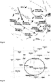
- FIGs 8 and 9 two exemplary radar images (according to image information included with the navigation data) are shown.
- a flight control radar-system provides a two-dimensional radar image of an aircraft above a certain altitude in the area by a flight control radar system 31 in the Midwest of the United States of America corresponding to the circle depicted in Figure 9 .
- the distance between Sawyer and Zenda in the United States of America is about 768 miles in a straight line.
- an image frame frequency is adapted, by the server entity 20, based on the travel data of the vehicle 10.
- an update of the navigation data is only transmitted to the vehicle 10 upon detection of an update of remote sensing data from the remote sensing system 31.
- the image information are linked to visual images available on the internet. Thereby, it is advantageously possible to show on the image displayed on the display means within the vehicle objects 1, 2, 3 in the vicinity of the vehicle 10 even under poor visibility (e.g. darkness).
- further information are displayed on the image, for example a specific icon for a maintenance-provision and/or fuel-provider.
- a billing mechanism being based on a quantity of time and data of service usage, is provided by the mobile communication network 100.
- the amount of navigation data transmitted to the vehicle 10 is reduced - in case of a connection failure of a connection between the vehicle 10 and the mobile communication network 100 - such that either a solution is adopted, as under smaller available bandwidth to the subscriber, which can be easily transferred, but may not have all details as under a good- or normal provision of such data, or such that the mobile communication network 100 nodes recognize the (new) location of the re-booked subscriber (which is located within the vehicle 10) and instantly provide the needed- and requested data to the vehicle 10.
Priority Applications (3)
| Application Number | Priority Date | Filing Date | Title |
|---|---|---|---|
| PL19181979T PL3576438T3 (pl) | 2015-08-11 | 2015-08-11 | Sposób zwiększania bezpieczeństwa nawigowania pojazdu przez dostarczanie danych nawigacyjnych czasu rzeczywistego do pojazdu za pośrednictwem sieci komunikacji mobilnej, system do zwiększania bezpieczeństwa nawigowania pojazdu przez dostarczanie danych nawigacyjnych czasu rzeczywistego do pojazdu za pośrednictwem sieci komunikacji mobilnej, program i produkt programu komputerowego |
| ES19181979T ES2820756T3 (es) | 2015-08-11 | 2015-08-11 | Método para potenciar la seguridad de navegación de un vehículo proporcionando al vehículo datos de navegación en tiempo real mediante una red de comunicaciones móviles, sistema para potenciar la seguridad de navegación de un vehículo proporcionando al vehículo datos de navegación en tiempo real mediante una red de comunicaciones móviles, programa y producto de programa informático |
| EP19181979.6A EP3576438B1 (de) | 2015-08-11 | 2015-08-11 | Verfahren zur verbesserung der sicherheit zum navigieren eines fahrzeugs durch die bereitstellung von echtzeitnavigationsdaten für das fahrzeug über ein mobilkommunikationsnetz, system zur verbesserung der sicherheit zum navigieren eines fahrzeugs durch die bereitstellung von echtzeitnavigationsdaten für das fahrzeug über ein mobilkommunikationsnetz, programm und computerprogrammprodukt |
Applications Claiming Priority (2)
| Application Number | Priority Date | Filing Date | Title |
|---|---|---|---|
| EP15180640.3A EP3131319B1 (de) | 2015-08-11 | 2015-08-11 | Verfahren, System und Programm zur Verbesserung der Navigationssicherheit eines Fahrzeugs durch Bereitstellung von Echtzeitnavigationsdaten an das Fahrzeug durch ein mobiles Kommunikationsnetzwerk |
| EP19181979.6A EP3576438B1 (de) | 2015-08-11 | 2015-08-11 | Verfahren zur verbesserung der sicherheit zum navigieren eines fahrzeugs durch die bereitstellung von echtzeitnavigationsdaten für das fahrzeug über ein mobilkommunikationsnetz, system zur verbesserung der sicherheit zum navigieren eines fahrzeugs durch die bereitstellung von echtzeitnavigationsdaten für das fahrzeug über ein mobilkommunikationsnetz, programm und computerprogrammprodukt |
Related Parent Applications (1)
| Application Number | Title | Priority Date | Filing Date |
|---|---|---|---|
| EP15180640.3A Division EP3131319B1 (de) | 2015-08-11 | 2015-08-11 | Verfahren, System und Programm zur Verbesserung der Navigationssicherheit eines Fahrzeugs durch Bereitstellung von Echtzeitnavigationsdaten an das Fahrzeug durch ein mobiles Kommunikationsnetzwerk |
Publications (2)
| Publication Number | Publication Date |
|---|---|
| EP3576438A1 true EP3576438A1 (de) | 2019-12-04 |
| EP3576438B1 EP3576438B1 (de) | 2020-07-22 |
Family
ID=53835940
Family Applications (2)
| Application Number | Title | Priority Date | Filing Date |
|---|---|---|---|
| EP15180640.3A Active EP3131319B1 (de) | 2015-08-11 | 2015-08-11 | Verfahren, System und Programm zur Verbesserung der Navigationssicherheit eines Fahrzeugs durch Bereitstellung von Echtzeitnavigationsdaten an das Fahrzeug durch ein mobiles Kommunikationsnetzwerk |
| EP19181979.6A Active EP3576438B1 (de) | 2015-08-11 | 2015-08-11 | Verfahren zur verbesserung der sicherheit zum navigieren eines fahrzeugs durch die bereitstellung von echtzeitnavigationsdaten für das fahrzeug über ein mobilkommunikationsnetz, system zur verbesserung der sicherheit zum navigieren eines fahrzeugs durch die bereitstellung von echtzeitnavigationsdaten für das fahrzeug über ein mobilkommunikationsnetz, programm und computerprogrammprodukt |
Family Applications Before (1)
| Application Number | Title | Priority Date | Filing Date |
|---|---|---|---|
| EP15180640.3A Active EP3131319B1 (de) | 2015-08-11 | 2015-08-11 | Verfahren, System und Programm zur Verbesserung der Navigationssicherheit eines Fahrzeugs durch Bereitstellung von Echtzeitnavigationsdaten an das Fahrzeug durch ein mobiles Kommunikationsnetzwerk |
Country Status (3)
| Country | Link |
|---|---|
| EP (2) | EP3131319B1 (de) |
| ES (1) | ES2820756T3 (de) |
| PL (2) | PL3576438T3 (de) |
Families Citing this family (6)
| Publication number | Priority date | Publication date | Assignee | Title |
|---|---|---|---|---|
| CN110366241A (zh) * | 2018-04-09 | 2019-10-22 | 华为技术有限公司 | 通信方法、装置和系统 |
| EP3910365A1 (de) | 2020-05-14 | 2021-11-17 | Nxp B.V. | Antennensystem und verfahren zum betrieb eines antennensystems |
| EP3910814A1 (de) | 2020-05-14 | 2021-11-17 | Nxp B.V. | Antennensystem und verfahren zum betrieb eines antennensystems |
| CN114071416B (zh) * | 2020-07-31 | 2023-11-24 | 中国电信股份有限公司 | 无人驾驶装置导航方法、系统和无人驾驶系统 |
| CN114283606A (zh) * | 2020-09-27 | 2022-04-05 | 阿波罗智联(北京)科技有限公司 | 用于车辆导航的方法、装置、设备、系统和云控平台 |
| CN114095804B (zh) * | 2022-01-19 | 2022-04-22 | 中国科学院空天信息创新研究院 | 一种基于航空遥感系统的空对地传输遥感数据的方法及系统 |
Citations (2)
| Publication number | Priority date | Publication date | Assignee | Title |
|---|---|---|---|---|
| US20040181340A1 (en) * | 2003-03-01 | 2004-09-16 | User-Centric Enterprises, Inc. | Rotating map and user-centric weather prediction |
| DE102012213619A1 (de) * | 2012-08-02 | 2014-02-27 | Robert Bosch Gmbh | Verfahren und mobiles Datenübertragungsgerät zur Übertragung von Routendaten bei einer Fahrt eines Fahrzeugs durch ein geografisches Gebiet, in dem eine Mobilfunkverbindung eines mobilen Datenübertragungsgeräts zu einem Fremdnetz besteht |
-
2015
- 2015-08-11 EP EP15180640.3A patent/EP3131319B1/de active Active
- 2015-08-11 ES ES19181979T patent/ES2820756T3/es active Active
- 2015-08-11 EP EP19181979.6A patent/EP3576438B1/de active Active
- 2015-08-11 PL PL19181979T patent/PL3576438T3/pl unknown
- 2015-08-11 PL PL15180640T patent/PL3131319T3/pl unknown
Patent Citations (2)
| Publication number | Priority date | Publication date | Assignee | Title |
|---|---|---|---|---|
| US20040181340A1 (en) * | 2003-03-01 | 2004-09-16 | User-Centric Enterprises, Inc. | Rotating map and user-centric weather prediction |
| DE102012213619A1 (de) * | 2012-08-02 | 2014-02-27 | Robert Bosch Gmbh | Verfahren und mobiles Datenübertragungsgerät zur Übertragung von Routendaten bei einer Fahrt eines Fahrzeugs durch ein geografisches Gebiet, in dem eine Mobilfunkverbindung eines mobilen Datenübertragungsgeräts zu einem Fremdnetz besteht |
Also Published As
| Publication number | Publication date |
|---|---|
| EP3131319B1 (de) | 2019-07-10 |
| ES2820756T3 (es) | 2021-04-22 |
| PL3576438T3 (pl) | 2020-12-14 |
| EP3576438B1 (de) | 2020-07-22 |
| PL3131319T3 (pl) | 2019-12-31 |
| EP3131319A1 (de) | 2017-02-15 |
Similar Documents
| Publication | Publication Date | Title |
|---|---|---|
| EP3131319B1 (de) | Verfahren, System und Programm zur Verbesserung der Navigationssicherheit eines Fahrzeugs durch Bereitstellung von Echtzeitnavigationsdaten an das Fahrzeug durch ein mobiles Kommunikationsnetzwerk | |
| US6804585B2 (en) | Flight management system and method for providing navigational reference to emergency landing locations | |
| EP2078218B1 (de) | System und verfahren für lokalisierung von luftturbulenzen | |
| US9355564B1 (en) | Position determination systems and methods for a plurality of aircraft | |
| US20080035784A1 (en) | Aircraft wake vortex predictor and visualizer | |
| US20160133138A1 (en) | Systems and methods for helicopter situational awareness and landing assistance | |
| US20080191902A1 (en) | Method and device for improving traffic safety | |
| US20140278062A1 (en) | Navigation system for use in an airport or harbor transportation | |
| US8768542B2 (en) | Method and system for assisting in the landing or the decking of a light aircraft | |
| US11587449B2 (en) | Systems and methods for guiding a vertical takeoff and landing vehicle to an emergency landing zone | |
| CN104539906A (zh) | 图像/激光测距/abs-b监控一体化系统 | |
| CN108917786A (zh) | 用于指示基于时间的要求的显示系统和方法 | |
| US9237313B2 (en) | Transverse vertical profile display for aeronautical routes | |
| EP3736538A1 (de) | Navigationsverhalten in städtischen luftfahrzeugen | |
| Ilcev | 13. Maritime Communication, Navigation and Surveillance (CNS) | |
| US20230215281A1 (en) | Systems and methods to corroborate an externally recommended flight plan change with flight management system | |
| KR20240047467A (ko) | 송신된 물체 위치 정보와 센서 기반 상대 물체 위치 정보를 조합한 운송수단 내비게이션 | |
| EP3859712A1 (de) | Kollisionswahrnehmung mit an einem fahrzeug montierten kameras | |
| EP3869486A1 (de) | Systeme und verfahren zum führen eines senkrecht startenden und landenden fahrzeugs in eine notlandezone | |
| DE102015215325A1 (de) | Verfahren zur Verbesserung der Sicherheit der Navigation eines Fahrzeugs durch Bereitstellen von Echtzeit-Navigationsdaten für das Fahrzeug über ein Mobilkommunikationsnetz, System zur Verbesserung der Sicherheit der Navigation eines Fahrzeugs durch Bereitstellen von Echtzeit-Navigationsdaten für das Fahrzeug über ein Mobilkommunikationsnetz, Programm und Computerprogrammprodukt | |
| WO2009094173A1 (en) | Method, system and apparatus for providing weather decision information to mobile users | |
| US20240144835A1 (en) | Systems and Methods for Radar-Based Aircraft Maneuver Actions | |
| CN212032370U (zh) | 机场场面运行要素的多源感知探测系统 | |
| EP4210022A1 (de) | Systeme und verfahren zur korrigierung einer extern empfohlenen flugplanänderung mit einem flugmanagementsystem | |
| EP4080483A1 (de) | Systeme und verfahren für strategischen intelligenten routenplanungsdienst für benutzer des städtischen luftraums |
Legal Events
| Date | Code | Title | Description |
|---|---|---|---|
| PUAI | Public reference made under article 153(3) epc to a published international application that has entered the european phase |
Free format text: ORIGINAL CODE: 0009012 |
|
| STAA | Information on the status of an ep patent application or granted ep patent |
Free format text: STATUS: THE APPLICATION HAS BEEN PUBLISHED |
|
| AC | Divisional application: reference to earlier application |
Ref document number: 3131319 Country of ref document: EP Kind code of ref document: P |
|
| AK | Designated contracting states |
Kind code of ref document: A1 Designated state(s): AL AT BE BG CH CY CZ DE DK EE ES FI FR GB GR HR HU IE IS IT LI LT LU LV MC MK MT NL NO PL PT RO RS SE SI SK SM TR |
|
| STAA | Information on the status of an ep patent application or granted ep patent |
Free format text: STATUS: REQUEST FOR EXAMINATION WAS MADE |
|
| 17P | Request for examination filed |
Effective date: 20200109 |
|
| RBV | Designated contracting states (corrected) |
Designated state(s): AL AT BE BG CH CY CZ DE DK EE ES FI FR GB GR HR HU IE IS IT LI LT LU LV MC MK MT NL NO PL PT RO RS SE SI SK SM TR |
|
| GRAP | Despatch of communication of intention to grant a patent |
Free format text: ORIGINAL CODE: EPIDOSNIGR1 |
|
| STAA | Information on the status of an ep patent application or granted ep patent |
Free format text: STATUS: GRANT OF PATENT IS INTENDED |
|
| INTG | Intention to grant announced |
Effective date: 20200302 |
|
| GRAS | Grant fee paid |
Free format text: ORIGINAL CODE: EPIDOSNIGR3 |
|
| GRAA | (expected) grant |
Free format text: ORIGINAL CODE: 0009210 |
|
| STAA | Information on the status of an ep patent application or granted ep patent |
Free format text: STATUS: THE PATENT HAS BEEN GRANTED |
|
| AC | Divisional application: reference to earlier application |
Ref document number: 3131319 Country of ref document: EP Kind code of ref document: P |
|
| AK | Designated contracting states |
Kind code of ref document: B1 Designated state(s): AL AT BE BG CH CY CZ DE DK EE ES FI FR GB GR HR HU IE IS IT LI LT LU LV MC MK MT NL NO PL PT RO RS SE SI SK SM TR |
|
| REG | Reference to a national code |
Ref country code: GB Ref legal event code: FG4D |
|
| REG | Reference to a national code |
Ref country code: CH Ref legal event code: EP |
|
| REG | Reference to a national code |
Ref country code: DE Ref legal event code: R096 Ref document number: 602015056384 Country of ref document: DE |
|
| REG | Reference to a national code |
Ref country code: AT Ref legal event code: REF Ref document number: 1294564 Country of ref document: AT Kind code of ref document: T Effective date: 20200815 |
|
| REG | Reference to a national code |
Ref country code: IE Ref legal event code: FG4D |
|
| REG | Reference to a national code |
Ref country code: LT Ref legal event code: MG4D |
|
| REG | Reference to a national code |
Ref country code: AT Ref legal event code: MK05 Ref document number: 1294564 Country of ref document: AT Kind code of ref document: T Effective date: 20200722 |
|
| PG25 | Lapsed in a contracting state [announced via postgrant information from national office to epo] |
Ref country code: HR Free format text: LAPSE BECAUSE OF FAILURE TO SUBMIT A TRANSLATION OF THE DESCRIPTION OR TO PAY THE FEE WITHIN THE PRESCRIBED TIME-LIMIT Effective date: 20200722 Ref country code: PT Free format text: LAPSE BECAUSE OF FAILURE TO SUBMIT A TRANSLATION OF THE DESCRIPTION OR TO PAY THE FEE WITHIN THE PRESCRIBED TIME-LIMIT Effective date: 20201123 Ref country code: LT Free format text: LAPSE BECAUSE OF FAILURE TO SUBMIT A TRANSLATION OF THE DESCRIPTION OR TO PAY THE FEE WITHIN THE PRESCRIBED TIME-LIMIT Effective date: 20200722 Ref country code: BG Free format text: LAPSE BECAUSE OF FAILURE TO SUBMIT A TRANSLATION OF THE DESCRIPTION OR TO PAY THE FEE WITHIN THE PRESCRIBED TIME-LIMIT Effective date: 20201022 Ref country code: SE Free format text: LAPSE BECAUSE OF FAILURE TO SUBMIT A TRANSLATION OF THE DESCRIPTION OR TO PAY THE FEE WITHIN THE PRESCRIBED TIME-LIMIT Effective date: 20200722 Ref country code: GR Free format text: LAPSE BECAUSE OF FAILURE TO SUBMIT A TRANSLATION OF THE DESCRIPTION OR TO PAY THE FEE WITHIN THE PRESCRIBED TIME-LIMIT Effective date: 20201023 Ref country code: FI Free format text: LAPSE BECAUSE OF FAILURE TO SUBMIT A TRANSLATION OF THE DESCRIPTION OR TO PAY THE FEE WITHIN THE PRESCRIBED TIME-LIMIT Effective date: 20200722 Ref country code: AT Free format text: LAPSE BECAUSE OF FAILURE TO SUBMIT A TRANSLATION OF THE DESCRIPTION OR TO PAY THE FEE WITHIN THE PRESCRIBED TIME-LIMIT Effective date: 20200722 Ref country code: NO Free format text: LAPSE BECAUSE OF FAILURE TO SUBMIT A TRANSLATION OF THE DESCRIPTION OR TO PAY THE FEE WITHIN THE PRESCRIBED TIME-LIMIT Effective date: 20201022 |
|
| PG25 | Lapsed in a contracting state [announced via postgrant information from national office to epo] |
Ref country code: RS Free format text: LAPSE BECAUSE OF FAILURE TO SUBMIT A TRANSLATION OF THE DESCRIPTION OR TO PAY THE FEE WITHIN THE PRESCRIBED TIME-LIMIT Effective date: 20200722 Ref country code: LV Free format text: LAPSE BECAUSE OF FAILURE TO SUBMIT A TRANSLATION OF THE DESCRIPTION OR TO PAY THE FEE WITHIN THE PRESCRIBED TIME-LIMIT Effective date: 20200722 Ref country code: IS Free format text: LAPSE BECAUSE OF FAILURE TO SUBMIT A TRANSLATION OF THE DESCRIPTION OR TO PAY THE FEE WITHIN THE PRESCRIBED TIME-LIMIT Effective date: 20201122 |
|
| PG25 | Lapsed in a contracting state [announced via postgrant information from national office to epo] |
Ref country code: NL Free format text: LAPSE BECAUSE OF FAILURE TO SUBMIT A TRANSLATION OF THE DESCRIPTION OR TO PAY THE FEE WITHIN THE PRESCRIBED TIME-LIMIT Effective date: 20200722 |
|
| REG | Reference to a national code |
Ref country code: CH Ref legal event code: PL |
|
| REG | Reference to a national code |
Ref country code: ES Ref legal event code: FG2A Ref document number: 2820756 Country of ref document: ES Kind code of ref document: T3 Effective date: 20210422 |
|
| REG | Reference to a national code |
Ref country code: DE Ref legal event code: R097 Ref document number: 602015056384 Country of ref document: DE |
|
| PG25 | Lapsed in a contracting state [announced via postgrant information from national office to epo] |
Ref country code: LU Free format text: LAPSE BECAUSE OF NON-PAYMENT OF DUE FEES Effective date: 20200811 Ref country code: EE Free format text: LAPSE BECAUSE OF FAILURE TO SUBMIT A TRANSLATION OF THE DESCRIPTION OR TO PAY THE FEE WITHIN THE PRESCRIBED TIME-LIMIT Effective date: 20200722 Ref country code: RO Free format text: LAPSE BECAUSE OF FAILURE TO SUBMIT A TRANSLATION OF THE DESCRIPTION OR TO PAY THE FEE WITHIN THE PRESCRIBED TIME-LIMIT Effective date: 20200722 Ref country code: DK Free format text: LAPSE BECAUSE OF FAILURE TO SUBMIT A TRANSLATION OF THE DESCRIPTION OR TO PAY THE FEE WITHIN THE PRESCRIBED TIME-LIMIT Effective date: 20200722 Ref country code: CH Free format text: LAPSE BECAUSE OF NON-PAYMENT OF DUE FEES Effective date: 20200831 Ref country code: CZ Free format text: LAPSE BECAUSE OF FAILURE TO SUBMIT A TRANSLATION OF THE DESCRIPTION OR TO PAY THE FEE WITHIN THE PRESCRIBED TIME-LIMIT Effective date: 20200722 Ref country code: LI Free format text: LAPSE BECAUSE OF NON-PAYMENT OF DUE FEES Effective date: 20200831 Ref country code: SM Free format text: LAPSE BECAUSE OF FAILURE TO SUBMIT A TRANSLATION OF THE DESCRIPTION OR TO PAY THE FEE WITHIN THE PRESCRIBED TIME-LIMIT Effective date: 20200722 |
|
| REG | Reference to a national code |
Ref country code: BE Ref legal event code: MM Effective date: 20200831 |
|
| PLBE | No opposition filed within time limit |
Free format text: ORIGINAL CODE: 0009261 |
|
| STAA | Information on the status of an ep patent application or granted ep patent |
Free format text: STATUS: NO OPPOSITION FILED WITHIN TIME LIMIT |
|
| PG25 | Lapsed in a contracting state [announced via postgrant information from national office to epo] |
Ref country code: AL Free format text: LAPSE BECAUSE OF FAILURE TO SUBMIT A TRANSLATION OF THE DESCRIPTION OR TO PAY THE FEE WITHIN THE PRESCRIBED TIME-LIMIT Effective date: 20200722 |
|
| 26N | No opposition filed |
Effective date: 20210423 |
|
| PG25 | Lapsed in a contracting state [announced via postgrant information from national office to epo] |
Ref country code: SK Free format text: LAPSE BECAUSE OF FAILURE TO SUBMIT A TRANSLATION OF THE DESCRIPTION OR TO PAY THE FEE WITHIN THE PRESCRIBED TIME-LIMIT Effective date: 20200722 |
|
| PG25 | Lapsed in a contracting state [announced via postgrant information from national office to epo] |
Ref country code: IE Free format text: LAPSE BECAUSE OF NON-PAYMENT OF DUE FEES Effective date: 20200811 Ref country code: BE Free format text: LAPSE BECAUSE OF NON-PAYMENT OF DUE FEES Effective date: 20200831 |
|
| REG | Reference to a national code |
Ref country code: NL Ref legal event code: MP Effective date: 20200722 |
|
| PG25 | Lapsed in a contracting state [announced via postgrant information from national office to epo] |
Ref country code: MT Free format text: LAPSE BECAUSE OF FAILURE TO SUBMIT A TRANSLATION OF THE DESCRIPTION OR TO PAY THE FEE WITHIN THE PRESCRIBED TIME-LIMIT Effective date: 20200722 Ref country code: CY Free format text: LAPSE BECAUSE OF FAILURE TO SUBMIT A TRANSLATION OF THE DESCRIPTION OR TO PAY THE FEE WITHIN THE PRESCRIBED TIME-LIMIT Effective date: 20200722 |
|
| PG25 | Lapsed in a contracting state [announced via postgrant information from national office to epo] |
Ref country code: MK Free format text: LAPSE BECAUSE OF FAILURE TO SUBMIT A TRANSLATION OF THE DESCRIPTION OR TO PAY THE FEE WITHIN THE PRESCRIBED TIME-LIMIT Effective date: 20200722 Ref country code: MC Free format text: LAPSE BECAUSE OF FAILURE TO SUBMIT A TRANSLATION OF THE DESCRIPTION OR TO PAY THE FEE WITHIN THE PRESCRIBED TIME-LIMIT Effective date: 20200722 |
|
| PG25 | Lapsed in a contracting state [announced via postgrant information from national office to epo] |
Ref country code: SI Free format text: LAPSE BECAUSE OF FAILURE TO SUBMIT A TRANSLATION OF THE DESCRIPTION OR TO PAY THE FEE WITHIN THE PRESCRIBED TIME-LIMIT Effective date: 20200722 |
|
| PGFP | Annual fee paid to national office [announced via postgrant information from national office to epo] |
Ref country code: TR Payment date: 20230808 Year of fee payment: 9 Ref country code: IT Payment date: 20230831 Year of fee payment: 9 Ref country code: GB Payment date: 20230824 Year of fee payment: 9 Ref country code: ES Payment date: 20230918 Year of fee payment: 9 |
|
| PGFP | Annual fee paid to national office [announced via postgrant information from national office to epo] |
Ref country code: PL Payment date: 20230728 Year of fee payment: 9 Ref country code: FR Payment date: 20230822 Year of fee payment: 9 Ref country code: DE Payment date: 20230822 Year of fee payment: 9 |