EP3571685B1 - Kostengünstige langzeitluftbilder - Google Patents
Kostengünstige langzeitluftbilder Download PDFInfo
- Publication number
- EP3571685B1 EP3571685B1 EP18709427.1A EP18709427A EP3571685B1 EP 3571685 B1 EP3571685 B1 EP 3571685B1 EP 18709427 A EP18709427 A EP 18709427A EP 3571685 B1 EP3571685 B1 EP 3571685B1
- Authority
- EP
- European Patent Office
- Prior art keywords
- data
- path
- camera device
- user
- region
- Prior art date
- Legal status (The legal status is an assumption and is not a legal conclusion. Google has not performed a legal analysis and makes no representation as to the accuracy of the status listed.)
- Active
Links
Images




Classifications
-
- H—ELECTRICITY
- H04—ELECTRIC COMMUNICATION TECHNIQUE
- H04N—PICTORIAL COMMUNICATION, e.g. TELEVISION
- H04N7/00—Television systems
- H04N7/18—Closed-circuit television [CCTV] systems, i.e. systems in which the video signal is not broadcast
- H04N7/183—Closed-circuit television [CCTV] systems, i.e. systems in which the video signal is not broadcast for receiving images from a single remote source
- H04N7/185—Closed-circuit television [CCTV] systems, i.e. systems in which the video signal is not broadcast for receiving images from a single remote source from a mobile camera, e.g. for remote control
-
- B—PERFORMING OPERATIONS; TRANSPORTING
- B64—AIRCRAFT; AVIATION; COSMONAUTICS
- B64B—LIGHTER-THAN AIR AIRCRAFT
- B64B1/00—Lighter-than-air aircraft
- B64B1/40—Balloons
- B64B1/50—Captive balloons
-
- B—PERFORMING OPERATIONS; TRANSPORTING
- B64—AIRCRAFT; AVIATION; COSMONAUTICS
- B64U—UNMANNED AERIAL VEHICLES [UAV]; EQUIPMENT THEREFOR
- B64U20/00—Constructional aspects of UAVs
- B64U20/80—Arrangement of on-board electronics, e.g. avionics systems or wiring
- B64U20/87—Mounting of imaging devices, e.g. mounting of gimbals
-
- G—PHYSICS
- G05—CONTROLLING; REGULATING
- G05D—SYSTEMS FOR CONTROLLING OR REGULATING NON-ELECTRIC VARIABLES
- G05D1/00—Control of position, course, altitude or attitude of land, water, air or space vehicles, e.g. using automatic pilots
-
- G—PHYSICS
- G05—CONTROLLING; REGULATING
- G05D—SYSTEMS FOR CONTROLLING OR REGULATING NON-ELECTRIC VARIABLES
- G05D1/00—Control of position, course, altitude or attitude of land, water, air or space vehicles, e.g. using automatic pilots
- G05D1/0011—Control of position, course, altitude or attitude of land, water, air or space vehicles, e.g. using automatic pilots associated with a remote control arrangement
- G05D1/0038—Control of position, course, altitude or attitude of land, water, air or space vehicles, e.g. using automatic pilots associated with a remote control arrangement by providing the operator with simple or augmented images from one or more cameras located onboard the vehicle, e.g. tele-operation
-
- G—PHYSICS
- G05—CONTROLLING; REGULATING
- G05D—SYSTEMS FOR CONTROLLING OR REGULATING NON-ELECTRIC VARIABLES
- G05D1/00—Control of position, course, altitude or attitude of land, water, air or space vehicles, e.g. using automatic pilots
- G05D1/0094—Control of position, course, altitude or attitude of land, water, air or space vehicles, e.g. using automatic pilots involving pointing a payload, e.g. camera, weapon, sensor, towards a fixed or moving target
-
- G—PHYSICS
- G05—CONTROLLING; REGULATING
- G05D—SYSTEMS FOR CONTROLLING OR REGULATING NON-ELECTRIC VARIABLES
- G05D1/00—Control of position, course, altitude or attitude of land, water, air or space vehicles, e.g. using automatic pilots
- G05D1/02—Control of position or course in two dimensions
-
- G—PHYSICS
- G05—CONTROLLING; REGULATING
- G05D—SYSTEMS FOR CONTROLLING OR REGULATING NON-ELECTRIC VARIABLES
- G05D1/00—Control of position, course, altitude or attitude of land, water, air or space vehicles, e.g. using automatic pilots
- G05D1/02—Control of position or course in two dimensions
- G05D1/0202—Control of position or course in two dimensions specially adapted to aircraft
-
- G—PHYSICS
- G05—CONTROLLING; REGULATING
- G05D—SYSTEMS FOR CONTROLLING OR REGULATING NON-ELECTRIC VARIABLES
- G05D1/00—Control of position, course, altitude or attitude of land, water, air or space vehicles, e.g. using automatic pilots
- G05D1/02—Control of position or course in two dimensions
- G05D1/0202—Control of position or course in two dimensions specially adapted to aircraft
- G05D1/0204—Control of position or course in two dimensions specially adapted to aircraft to counteract a sudden perturbation, e.g. cross-wind, gust
-
- G—PHYSICS
- G05—CONTROLLING; REGULATING
- G05D—SYSTEMS FOR CONTROLLING OR REGULATING NON-ELECTRIC VARIABLES
- G05D1/00—Control of position, course, altitude or attitude of land, water, air or space vehicles, e.g. using automatic pilots
- G05D1/08—Control of attitude, i.e. control of roll, pitch, or yaw
- G05D1/0808—Control of attitude, i.e. control of roll, pitch, or yaw specially adapted for aircraft
- G05D1/0866—Control of attitude, i.e. control of roll, pitch, or yaw specially adapted for aircraft specially adapted to captive aircraft
-
- G—PHYSICS
- G06—COMPUTING OR CALCULATING; COUNTING
- G06T—IMAGE DATA PROCESSING OR GENERATION, IN GENERAL
- G06T7/00—Image analysis
- G06T7/10—Segmentation; Edge detection
- G06T7/11—Region-based segmentation
-
- G—PHYSICS
- G06—COMPUTING OR CALCULATING; COUNTING
- G06V—IMAGE OR VIDEO RECOGNITION OR UNDERSTANDING
- G06V10/00—Arrangements for image or video recognition or understanding
- G06V10/20—Image preprocessing
- G06V10/24—Aligning, centring, orientation detection or correction of the image
- G06V10/242—Aligning, centring, orientation detection or correction of the image by image rotation, e.g. by 90 degrees
-
- G—PHYSICS
- G06—COMPUTING OR CALCULATING; COUNTING
- G06V—IMAGE OR VIDEO RECOGNITION OR UNDERSTANDING
- G06V10/00—Arrangements for image or video recognition or understanding
- G06V10/70—Arrangements for image or video recognition or understanding using pattern recognition or machine learning
- G06V10/74—Image or video pattern matching; Proximity measures in feature spaces
- G06V10/75—Organisation of the matching processes, e.g. simultaneous or sequential comparisons of image or video features; Coarse-fine approaches, e.g. multi-scale approaches; using context analysis; Selection of dictionaries
- G06V10/751—Comparing pixel values or logical combinations thereof, or feature values having positional relevance, e.g. template matching
-
- G—PHYSICS
- G06—COMPUTING OR CALCULATING; COUNTING
- G06V—IMAGE OR VIDEO RECOGNITION OR UNDERSTANDING
- G06V20/00—Scenes; Scene-specific elements
- G06V20/10—Terrestrial scenes
- G06V20/13—Satellite images
-
- G—PHYSICS
- G08—SIGNALLING
- G08C—TRANSMISSION SYSTEMS FOR MEASURED VALUES, CONTROL OR SIMILAR SIGNALS
- G08C17/00—Arrangements for transmitting signals characterised by the use of a wireless electrical link
- G08C17/02—Arrangements for transmitting signals characterised by the use of a wireless electrical link using a radio link
-
- G—PHYSICS
- G08—SIGNALLING
- G08G—TRAFFIC CONTROL SYSTEMS
- G08G5/00—Traffic control systems for aircraft
- G08G5/20—Arrangements for acquiring, generating, sharing or displaying traffic information
- G08G5/22—Arrangements for acquiring, generating, sharing or displaying traffic information located on the ground
-
- G—PHYSICS
- G08—SIGNALLING
- G08G—TRAFFIC CONTROL SYSTEMS
- G08G5/00—Traffic control systems for aircraft
- G08G5/20—Arrangements for acquiring, generating, sharing or displaying traffic information
- G08G5/26—Transmission of traffic-related information between aircraft and ground stations
-
- G—PHYSICS
- G08—SIGNALLING
- G08G—TRAFFIC CONTROL SYSTEMS
- G08G5/00—Traffic control systems for aircraft
- G08G5/30—Flight plan management
- G08G5/32—Flight plan management for flight plan preparation
-
- G—PHYSICS
- G08—SIGNALLING
- G08G—TRAFFIC CONTROL SYSTEMS
- G08G5/00—Traffic control systems for aircraft
- G08G5/50—Navigation or guidance aids
- G08G5/55—Navigation or guidance aids for a single aircraft
-
- G—PHYSICS
- G08—SIGNALLING
- G08G—TRAFFIC CONTROL SYSTEMS
- G08G5/00—Traffic control systems for aircraft
- G08G5/70—Arrangements for monitoring traffic-related situations or conditions
- G08G5/74—Arrangements for monitoring traffic-related situations or conditions for monitoring terrain
-
- H—ELECTRICITY
- H04—ELECTRIC COMMUNICATION TECHNIQUE
- H04N—PICTORIAL COMMUNICATION, e.g. TELEVISION
- H04N23/00—Cameras or camera modules comprising electronic image sensors; Control thereof
- H04N23/60—Control of cameras or camera modules
- H04N23/62—Control of parameters via user interfaces
-
- H—ELECTRICITY
- H04—ELECTRIC COMMUNICATION TECHNIQUE
- H04N—PICTORIAL COMMUNICATION, e.g. TELEVISION
- H04N23/00—Cameras or camera modules comprising electronic image sensors; Control thereof
- H04N23/60—Control of cameras or camera modules
- H04N23/63—Control of cameras or camera modules by using electronic viewfinders
-
- H—ELECTRICITY
- H04—ELECTRIC COMMUNICATION TECHNIQUE
- H04N—PICTORIAL COMMUNICATION, e.g. TELEVISION
- H04N23/00—Cameras or camera modules comprising electronic image sensors; Control thereof
- H04N23/60—Control of cameras or camera modules
- H04N23/64—Computer-aided capture of images, e.g. transfer from script file into camera, check of taken image quality, advice or proposal for image composition or decision on when to take image
-
- H—ELECTRICITY
- H04—ELECTRIC COMMUNICATION TECHNIQUE
- H04N—PICTORIAL COMMUNICATION, e.g. TELEVISION
- H04N23/00—Cameras or camera modules comprising electronic image sensors; Control thereof
- H04N23/60—Control of cameras or camera modules
- H04N23/65—Control of camera operation in relation to power supply
-
- H—ELECTRICITY
- H04—ELECTRIC COMMUNICATION TECHNIQUE
- H04N—PICTORIAL COMMUNICATION, e.g. TELEVISION
- H04N23/00—Cameras or camera modules comprising electronic image sensors; Control thereof
- H04N23/60—Control of cameras or camera modules
- H04N23/66—Remote control of cameras or camera parts, e.g. by remote control devices
-
- H—ELECTRICITY
- H04—ELECTRIC COMMUNICATION TECHNIQUE
- H04N—PICTORIAL COMMUNICATION, e.g. TELEVISION
- H04N23/00—Cameras or camera modules comprising electronic image sensors; Control thereof
- H04N23/60—Control of cameras or camera modules
- H04N23/66—Remote control of cameras or camera parts, e.g. by remote control devices
- H04N23/661—Transmitting camera control signals through networks, e.g. control via the Internet
-
- H—ELECTRICITY
- H04—ELECTRIC COMMUNICATION TECHNIQUE
- H04N—PICTORIAL COMMUNICATION, e.g. TELEVISION
- H04N7/00—Television systems
- H04N7/18—Closed-circuit television [CCTV] systems, i.e. systems in which the video signal is not broadcast
- H04N7/183—Closed-circuit television [CCTV] systems, i.e. systems in which the video signal is not broadcast for receiving images from a single remote source
-
- B—PERFORMING OPERATIONS; TRANSPORTING
- B64—AIRCRAFT; AVIATION; COSMONAUTICS
- B64U—UNMANNED AERIAL VEHICLES [UAV]; EQUIPMENT THEREFOR
- B64U10/00—Type of UAV
- B64U10/30—Lighter-than-air aircraft, e.g. aerostatic aircraft
-
- B—PERFORMING OPERATIONS; TRANSPORTING
- B64—AIRCRAFT; AVIATION; COSMONAUTICS
- B64U—UNMANNED AERIAL VEHICLES [UAV]; EQUIPMENT THEREFOR
- B64U2201/00—UAVs characterised by their flight controls
- B64U2201/20—Remote controls
- B64U2201/202—Remote controls using tethers for connecting to ground station
-
- G—PHYSICS
- G06—COMPUTING OR CALCULATING; COUNTING
- G06T—IMAGE DATA PROCESSING OR GENERATION, IN GENERAL
- G06T2207/00—Indexing scheme for image analysis or image enhancement
- G06T2207/10—Image acquisition modality
- G06T2207/10032—Satellite or aerial image; Remote sensing
-
- G—PHYSICS
- G08—SIGNALLING
- G08C—TRANSMISSION SYSTEMS FOR MEASURED VALUES, CONTROL OR SIMILAR SIGNALS
- G08C2201/00—Transmission systems of control signals via wireless link
- G08C2201/90—Additional features
- G08C2201/93—Remote control using other portable devices, e.g. mobile phone, PDA, laptop
-
- G—PHYSICS
- G08—SIGNALLING
- G08G—TRAFFIC CONTROL SYSTEMS
- G08G5/00—Traffic control systems for aircraft
- G08G5/50—Navigation or guidance aids
- G08G5/57—Navigation or guidance aids for unmanned aircraft
Definitions
- UAVs Unmanned Aerial Vehicles
- US9508263B1 discloses systems and methods for generating a digital flight path within complex mission boundaries.
- systems and methods generate flight legs that traverse a target site within mission boundaries.
- one or more embodiments include systems and methods that utilize linking algorithms to connect the generated flight legs into a flight path.
- one or more embodiments include systems and methods that generate a mission plan based on the flight path.
- the generated mission plan enables a UAV to traverse a flight area within mission boundaries and capture aerial images with regard to the target site.
- WO2014/027097A2 discloses an arrangement comprising, a volitant body comprising at least one actuator; a control unit for controlling said actuator;and a mechanical arrangement for operationally connecting said volitant body to a reference point remote from said volitant body. There is further provided a corresponding method for operating such an arrangement.
- US2016/253908A1 discloses an Unmanned Aerial System configured to receive a request from a user and fulfill that request using an Unmanned Aerial Vehicle.
- Unmanned Aerial System selects a distribution center that is within range of the user, and deploys a suitable Unmanned Aerial Vehicle to fulfill the request from that distribution center.
- the Unmanned Aerial System is configured to provide real-time information about the flight route to the Unmanned Aerial Vehicle during its flight, and the Unmanned Aerial Vehicle is configured to dynamically update its mission based on information received from the Unmanned Aerial System.
- US2016/191793A1 discloses a mobile terminal and a method of controlling therefor.
- the mobile terminal includes a touch interface module configured to receive a touch input, a communication module configured to establish communication with at least one or more drones and a controller configured to control the communication module and the touch interface module.
- the controller transmits location information of the mobile terminal to the drone with which the communication is established, designates a position of the drone based on the transmitted location information, receives a preview image obtained by a camera of the drone, displays the received preview image on a predetermined first area and if the touch input is recognized, captures the preview image displayed on the first area.
- US9019376B2 discloses that in a method for controlling an unmanned aerial vehicle (UAV) equipped with a camera to capture images of a target, the computing device sets coordinates of a target, initial coordinates of the camera, and an initial viewing direction of the camera. Real-time coordinates and a real-time viewing direction of the camera are obtained when the UAV flies around the target. Accordingly, adjustment parameters of the camera are calculated and transferred to a driver system connected to the camera, such that the driver system adjusts the camera to face the target according to the adjusting parameters.
- UAV unmanned aerial vehicle
- Embodiments of the disclosure include apparatus and methods for use in an imaging system.
- the imaging system may be configured to include an aerial platform configured to rise to a height above ground.
- the aerial platform may be an apparatus such as a balloon or a kite.
- the aerial platform may include a steering apparatus that allows an entity on the ground to move the aerial platform in a desired direction when the aerial platform is suspended above ground.
- the steering device may be a tether that allows the user/entity on the ground to control the height and position of the aerial platform.
- a camera device may be attached to the aerial platform and oriented in a direction to take images, including still images or videos, of the ground.
- the camera device may also include a position sensor such as a global poisoning satellite (GPS) device and a wireless interface for communicating with other devices.
- GPS global poisoning satellite
- the imaging system may also include a mobile device that also has a wireless interface and that communicates with the camera device over the wireless interface.
- the mobile device may be a device such as a smart phone or tablet device and may have a user interface to receive input from, and provide output to, a user that may be the user/entity on the ground who controls the aerial platform using the steering device.
- the mobile device may receive first data related to a region to be imaged by the camera device.
- the first data may be entered at the user interface by the user.
- the first data may include, for example, dimensional parameters of the region and at least one indication of an area of importance within the region.
- the mobile device may also receive second data that includes information related to a field of vision of the camera device.
- the second data may include, for example, data on the height of the aerial platform/camera device and /or image resolution data that may be input to the mobile device by the user or by some other method, such a being pre-stored or downloaded to the mobile device.
- the mobile device may determine a first path within the region and provide information on the first path to the use/entity at the user interface.
- the user/entity may then use the steering device to move the aerial platform with the user/entity as the user/entity moves along the first path according to the information on the first path received at the user interface.
- the mobile device receives third data from the position sensor of the camera device.
- the third data may include position data determined at the time of capture of each image or video frame of the region of interest by the camera device.
- the mobile device may determine a second path within the region and provide information on the second path to the user/entity.
- the second path may be determined to account for at least one unimaged area of the region that remains unimaged in the traverse of the first path.
- the user/entity may then use the steering device to move the aerial platform along a traverse of the second path according to the information on the second path received at the user interface and capture additional images of the region.
- the first path may be constructed and/or adjusted in real time as the user moves along the first path with the aerial platform.
- the imaging system includes a control device that includes an apparatus that allows a user to increase the longevity of camera battery life by duty cycling and/or controlling the camera device remotely so that only basic functionalities are running, except when other functions are needed.
- the user may use the apparatus to capture imagery at a time scale of interest by adjusting parameters related to image capture by the camera device.
- the implementation includes an apparatus that is configured to receive first data, the first data comprising information related to a region to be imaged and information related to a field of vision of a camera device positioned above a mobile entity on an aerial platform having a steering device, receive second data, the second data indicating a parameter related to power consumption by the camera device, and provide the second data to the camera device.
- the second data may include a time for the camera device to capture an image, a time for the camera device to capture a video, or a number of cycles per time period for the camera device to capture one or more images.
- the apparatus may then determine, based at least on the first data, path planning to provide to the mobile entity for imaging the region.
- the apparatus may comprise a mobile device including a user interface and the mobile device receives the second data indicating a parameter related to power consumption from the user interface in response to the mobile entity entering input at the user interface.
- the apparatus may also determine a battery life of the camera device based at least on the second data, and present an indication of the battery life to the mobile entity at the user interface.
- a user may then modify the time for the camera device to capture an image, the time for the camera device to capture a video, or the number of cycles per time period for the camera device according to the battery life and the time needed to image a particular region.
- the imaging system includes a control device including an apparatus that is configured to receive a plurality of images from a camera device, extract a plurality of features from the plurality of images, reject selected features of the plurality of features that do not match across the plurality of images, determine a homography that maps features in each image of the plurality of images to features in another image of the plurality of images, and apply the homography to a current image captured from the camera device and ensure that the current image is aligned to an image previous to the current image.
- This image alignment allows the use of an aerial platform that is less expensive, but may be susceptible to translations and rotations in the air to that cause unwanted motion of the camera device due to the impact of wind on the aerial platform.
- the imaging system may include an aerial platform configured to rise to a height above ground.
- the aerial platform may include a balloon and a steering apparatus that allows an entity on the ground to move the aerial platform in a desired direction when the aerial platform is above ground.
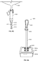
- the imaging system may further include a mount including a member having a long axis, a first end, and a second end, the mount further includes a swiveling apparatus that couples the first end of the member to the aerial platform, wherein the member to hangs substantially perpendicular along its long axis to the ground from the aerial platform.
- the mount also includes a case having a first portion and a second portion. The first portion of the case is coupled to the second end of the elongated member. The case is configured to receive a camera device and hold the camera device so that focal plane of the camera device is perpendicular to the long axis of the member.
- the disclosed embodiments include apparatus, devices, and methods for use in a system for large-scale high-resolution aerial photography of a region of interest.
- the apparatus, devices, and methods provide a practical and low-cost alternative to aerial imaging based on the use of unmanned powered aerial vehicles such as quadcopters and fixed wing drones in situations when the use of these types of aerial vehicles is infeasible due to limited battery life, cost, and/or regulatory restrictions.
- the embodiments also provide advantages over aerial imaging based on the use of satellites or airplanes, which can be expensive and not flexible enough for many users.
- Use of the embodiments optimizes coverage of a target area for imaging in a region of interest in spite of variations in the position of the camera device and aerial platform with respect to an anchor or tether point.
- the embodiments allow a user to acquire high quality aerial imagery over extended areas of a region, or over long stretches of time, while keeping the total cost of such acquisition much lower than when using powered aerial vehicles.
- implementations have application in agricultural farm monitoring, flood analysis and crowd monitoring. These applications conventionally require expensive infrastructure (such as camera towers or human operated blimps) to be cost effective and feasible.
- the embodiments provide advantages over other conventional techniques such as use of UAVs, satellites and cameras attached to airplanes. For example, much satellite imagery data is available at no cost but the imagery data has shortcomings. Commonly available satellite imaging resolution is poor. The best resolution is on the order of 46 cm per pixel. Also, image data collected from satellites is severely affected by cloud cover and, hence, not suitable for many applications. Additionally, satellite images are usually old when obtained since most satellites have a turnaround period on the order of days. Even though better images that provide good resolution may be obtained through private commercial satellite systems, these commercial images are very expensive. These commercial images normally have a minimum order requirement and cost thousands of dollars. The aforementioned factors make satellite imagery unsuitable for many applications and especially the small scale ones. Airplane cameras provide better resolution images than satellites, but suffer from similar disadvantages as they are also very expensive.
- UAVs have many disadvantages.
- a mid to heavy payload carrying drone may cost thousands of dollars.
- the capital investment cost of using drones may be high.
- UAVs have limited battery life which mandates a limited flight time and a UAV needs to be charged regularly for continuous image capture. If a UAV's batteries undergo several cycles of charging/discharging, then battery longevity is reduced and the batteries would need to be replaced. Thus drones don't just incur an initial capital cost but also a moderately high operational cost.
- One big disadvantage of using UAVs comes in the form of regulations which restrict how, where and when UAVs may be used.
- the embodiments of this disclosure provide low-cost alternatives to the above discussed methods of aerial imaging.
- the embodiments provide systems having longevity. Once the system is up and running, it should last for a long enough time without the need for human intervention.
- the embodiments also provide systems that allow as low a cost of the system as possible. This making it economical for persons in developing countries to easily use the system and its new technologies.
- the aerial platform based imaging of the embodiments is flexible and programmable.
- a user is able to choose the area of interest, the quality of the imagery, the duty cycling etc., flexibly, as per need.
- a user is also able to make adjustments of battery life for given applications by remotely changing parameters of the camera device related to power consumption. For example, a user may adjust a length of time for capture of a still image, a length of time for capture of a video, or a number of cycles per a time period for taking one or more images in order to adjust power consumption in view of available battery power.
- the embodiments utilize an aerial platform such as a tethered balloon to be used as a low-cost drone to carry a camera device.
- an aerial platform is low cost and may be shared across many users. For example, in an agriculture application a group of farmers interested in documenting crop growth could share a single imaging system.
- the imaging system may be made mobile by tethering the system to a moving vehicle instead of a stationary point on the ground.
- an aerial imaging system with an unstable camera is not preferred for creating panoramic views of an area of interest.
- the embodiments use techniques and methods that account for wind motion by flexibly mounting the camera device to the aerial platform to allow the camera device to remain substantially parallel to the ground, and also correct for wind motion by stabilizing the camera and using a pre-planned path to capture aerial imagery.
- the pre-planned path includes two-step path determination that accounts for wind disturbances mid-way through the imaging.
- implementations of the embodiments utilize image matching techniques that extract a plurality of features from the plurality of images, reject selected features of the plurality of features that do not match across the plurality of images, and determine a homography that allows a current image to be aligned to a previous image. This also helps in accounting for wind motion and the susceptibility of the aerial platform to translations and rotations in the air due to the impact of wind.
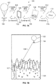
- FIGURE 1A is an illustration of an example aerial imaging system.
- FIGURE 1 shows a system 100 that includes aerial platform 102 (shown as example balloon 102), camera device 104, ground communication device (GCD) 106 (shown as example mobile device 106 having user interface touch screen 107), gateway node 108, and cloud network 110.
- system 100 may be configured to be operable in two modes, stationary mode or mobile mode.
- Stationary mode of operation is suitable for applications where the region of interest for imaging remains constant and changes in the area are to be tracked regularly for a long period of time.
- this mode may be used for imaging crop growth or flooding at a useful time granularity.
- the aerial balloon 102 may be tethered to a single stationary point on the ground for an extended period of time (days to weeks).
- the balloon 102 may be a reusable helium filled balloon with a payload which consists of camera device 104 which is programmable and has its own power source.
- the camera device 104 may be pointed towards the object of interest which in this case is the ground plane of the area of interest.
- the GCD 106 may perform two functions.
- the first function is to upload the imagery 124 to the gateway node 108 which has connectivity to the internet using an appropriate wireless technology having channels configured according to a Wi-Fi standard, or configured to operate using channels in the TV white spaces (TVWS).
- the second function is to enable duty cycling of the camera device 104.
- the GCD 106 may be programmed to turn on the camera device 104 remotely, trigger the camera device 104 to capture imagery, transfer the imagery to the interface and power off the camera device 104 -essentially acting as a remote controller by sending commands 122 to camera device 104.
- the gateway node 108 may also perform two functions. First, gateway node 108 functions as a node with computational capabilities not provided by camera device 104 or GCD 106. The gateway node 108 may execute initial vision based post-processing on the imaging data 118 that is being sent from the GCD 106. Second, the gateway node 106 may act as a gateway to upload data 112 to the cloud network 110 where further applications could run on the imaging data and provide the user with further processed data 116. In one implementation, the local processing performed by GCD 106 may be used to conserve bandwidth (as videos can be very large) as well as to maintain system robustness during any cloud connectivity outages.
- long-term analytics may be run on the cloud network110 and the gateway node 108 may processes the immediately data and presents the farmer with immediate short term analytics 120.
- the GCD 108 may directly upload the videos to the cloud network 110 without using the gateway node 108. Then, instead of accessing imaging data locally, a user may access the imaging data directly from the cloud network 110.
- multiple cameras may be strategically placed to ensure coverage. For example, multiple cameras may be used when height regulations and/or the camera's field-of-view (FOV) limits the area imaged by a single camera device.
- FOV field-of-view
- Mobile mode of operation may be used where the region of interest for imaging is larger than what can be achieved using a stationary camera and when the granularity at which updated imagery data is needed is appropriate for use of mobile mode. For example, if a large region is to be mapped once a day, mobile mode may be used. Mobile mode may also provide an advantage if a community or group of users want to share resources (say for example a farming community in a developing country).
- FIGURE 1B is an illustration of use of an example system in mobile mode.
- FIGURE 1 shows the balloon 102 of system 100 connected by tether 105 to user 107.
- Balloon 102 and tether 105 may be configured to allow balloon 102 to rise to a desired height above ground.
- the length of tether 105 and the amount of gas, such as helium, in balloon 102 may be set to cause balloon 102 to float at a desired height.
- Camera device 104 is mounted below balloon 102 and is positioned to point at region of interest 109 on the ground.
- the balloon may be tethered to any type of mobile point, for example tethered to a vehicle such as a bicycle or an automated vehicle.
- User 107 may manipulate tether 105 to move balloon 102 and camera device 104 to obtain images of a region of interest.
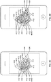
- the GCD 108 runs an application that provides guidance information (path planning) to a user/entity about how to cover the area of interest efficiently in addition to serving as an interface between the camera device 104 and the gateway node 108 and as a remote controller for the camera device 104.
- the system 100 utilizes a path planning function configured in GCD 108.
- the path planning function is configured to first determine and efficiently utilize the area captured by images or video taken from camera device 104 for a current system configuration.
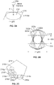
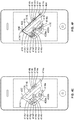
- FIGURE 2A is a diagram illustrating an example imaging area of camera device 104 of system 100
- FIGURE 2B is a diagram illustrating example of determining imaging areas of a camera device.
- the image captured in every frame/image from camera device 104 may be represented as a circle 212.
- FOV field-of-view
- ⁇ horizontal FOV
- the aerial platform/balloon 102 for mounting the camera device 104 may be designed in such a way that the camera faces the ground with maximum/high probability. However, there is a rotatory motion about the axis normal to the ground (in the plane parallel to the ground). If the balloon 102 is currently stationary and wind doesn't shift the tethered balloon, it is still difficult to exactly estimate what area is getting imaged because of the local rotation at the pivot where camera device 104 is attached to the balloon.
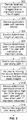
- FIGURE 5B is a flow diagram illustrating example operations for determining a subsequent path to follow for imaging unimaged areas for a region of interest.
- the operations of FGURE 5B may be performed by GCD 106 at operation 314 of FIGURE 3 .
- the process begins at 506 where GCD 106 determines the unimaged areas of the region of interest, the vertices of the areas to be imaged, the current position of the camera device 104, the important areas of the region, and the height of the camera device 104.
- GCD 106 breaks any unimaged areas greater than one image circle size into parts equal to or less than one image size.
Landscapes
- Engineering & Computer Science (AREA)
- Physics & Mathematics (AREA)
- General Physics & Mathematics (AREA)
- Multimedia (AREA)
- Aviation & Aerospace Engineering (AREA)
- Signal Processing (AREA)
- Remote Sensing (AREA)
- Theoretical Computer Science (AREA)
- Radar, Positioning & Navigation (AREA)
- Automation & Control Theory (AREA)
- Computer Vision & Pattern Recognition (AREA)
- Mechanical Engineering (AREA)
- Computer Networks & Wireless Communication (AREA)
- Databases & Information Systems (AREA)
- Astronomy & Astrophysics (AREA)
- Health & Medical Sciences (AREA)
- Artificial Intelligence (AREA)
- Computing Systems (AREA)
- Human Computer Interaction (AREA)
- Evolutionary Computation (AREA)
- General Health & Medical Sciences (AREA)
- Medical Informatics (AREA)
- Software Systems (AREA)
- Microelectronics & Electronic Packaging (AREA)
- Studio Devices (AREA)
- Closed-Circuit Television Systems (AREA)
Claims (11)
- Einrichtung, umfassend:einen oder mehrere Prozessoren (702) und,Speicher (712) in Kommunikation mit dem einen oder den mehreren Prozessoren, wobei der Speicher Code (714, 716, 718, 720, 722) umfasst, der bei Ausführung veranlasst, dass der eine oder die mehreren Prozessoren die Einrichtung steuern zum:Empfangen von ersten Daten (302), wobei die ersten Daten Informationen, die sich auf eine abzubildende Region beziehen, und Informationen umfassen, die sich auf ein Sichtfeld einer Kameravorrichtung beziehen, die über einer mobilen Einheit auf einer Luftplattform mit einer Lenkvorrichtung positioniert ist, wobei die ersten Daten von einem Benutzer eingegeben werden;Bestimmen (308), basierend mindestens auf den ersten Daten, eines Pfads innerhalb der Region und Bereitstellen von Informationen über den ersten Pfad an die mobile Einheit;dadurch gekennzeichnet, dass der Code bei Ausführung den einen oder die mehreren Prozessoren weiterhin veranlasst, die Einrichtung zu steuern zum:Empfangen von zweiten Daten (302), wobei die zweiten Daten einen Parameter angeben, der sich auf den Stromverbrauch von der Kameravorrichtung bezieht, und Bereitstellen der zweiten Daten an die Kameravorrichtung;Empfangen (312) von dritten Daten von der Kameravorrichtung, wenn die mobile Einheit die Luftplattform entlang des ersten Pfades unter Verwendung der Lenkeinrichtung bewegt, wobei die dritten Daten ein oder mehrere Bilder einschließen, die von der Kameravorrichtung gemäß den zweiten Daten aufgenommen werden.
- Einrichtung nach Anspruch 1, wobei die zweiten Daten eine Zeitdauer zum Erfassen eines Standbildes einschließen.
- Einrichtung nach Anspruch 1, wobei die zweiten Daten eine Zeitdauer zum Erfassen eines Videos einschließen.
- Einrichtung nach Anspruch 1, wobei die zweiten Daten eine Anzahl von Zyklen pro Zeitraum zum Aufnehmen eines Standbildes einschließen.
- Einrichtung nach Anspruch 1, wobei die Einrichtung weiterhin eine mobile Vorrichtung umfasst, die eine Benutzeroberfläche in Kommunikation mit dem einen oder den mehreren Prozessoren einschließt, und der Code weiterhin veranlasst, dass der eine oder die mehreren Prozessoren die mobile Vorrichtung steuert, um die zweiten Daten von der Benutzeroberfläche als Antwort auf die Eingabe der mobilen Einheit an der Benutzeroberfläche zu empfangen.
- Einrichtung nach Anspruch 5, wobei der Code bei Ausführung den einen oder die mehreren Prozessoren weiterhin veranlasst, die Einrichtung zu steuern zum:Bestimmen einer Batterielebensdauer der Kameravorrichtung basierend auf mindestens den zweiten Daten; undPräsentieren einer Angabe der Batterielebensdauer auf der Benutzeroberfläche.
- Einrichtung nach Anspruch 1, wobei der Code bei Ausführung den einen oder die mehreren Prozessoren weiterhin veranlasst, die Einrichtung zu steuern zum:Empfangen von vierten Daten, wobei die vierten Daten Positionsdaten der Kameravorrichtung umfassen, wenn die mobile Einheit die Luftplattform entlang des ersten Pfades unter Verwendung der Lenkeinrichtung bewegt;Bestimmen, basierend auf mindestens den vierten Daten, mindestens eines nicht abgebildeten Bereichs der Region, der bei der Durchquerung des ersten Pfades unabgebildet bleibt; und,Bestimmen, basierend mindestens auf dem mindestens einen unabgebildeten Bereich und den ersten Daten, eines zweiten Pfads innerhalb der Region und Bereitstellen von Informationen über den zweiten Pfad an die mobile Einheit.
- Einrichtung nach Anspruch 1, weiterhin umfassend einen Ballon, wobei der Ballon die Luftplattform bereitstellt, auf der die Kameravorrichtung montiert ist, und die Lenkvorrichtung einen Haltegurt umfasst.
- Einrichtung nach Anspruch 1, weiterhin umfassend eine mobile Vorrichtung, wobei die mobile Vorrichtung die Kameravorrichtung einschließt und die mobile Vorrichtung unter dem Ballon montiert ist.
- Verfahren, umfassend:Empfangen von ersten Daten (302), wobei die ersten Daten Informationen, die sich auf eine abzubildende Region beziehen, und Informationen umfassen, die sich auf ein Sichtfeld einer Kameravorrichtung beziehen, die über einer mobilen Einheit auf einer Luftplattform mit einer Lenkvorrichtung positioniert ist, wobei die ersten Daten von einem Benutzer eingegeben werden;Bestimmen (308), mindestens basierend auf den ersten Daten, eines Pfads innerhalb der Region und Bereitstellen von Informationen über den ersten Pfad an die mobile Einheit;dadurch gekennzeichnet, dass das Verfahren weiterhin umfasst:Empfangen von zweiten Daten (302), wobei die zweiten Daten einen Parameter angeben, der sich auf den Stromverbrauch von der Kameravorrichtung bezieht, und Bereitstellen der zweiten Daten an die Kameravorrichtung;Empfangen (312) von dritten Daten von der Kameravorrichtung, wenn die mobile Einheit die Luftplattform entlang des ersten Pfades unter Verwendung der Lenkeinrichtung bewegt, wobei die dritten Daten ein oder mehrere Bilder einschließen, die von der Kameravorrichtung gemäß den zweiten Daten aufgenommen werden.
- Computerlesbares Speichermedium zum Speichern computerlesbarer Anweisungen, wobei die computerlesbaren Anweisungen, wenn sie von einem oder mehreren Prozessorvorrichtungen ausgeführt werden, das Verfahren nach Anspruch 10 durchführen.
Priority Applications (2)
| Application Number | Priority Date | Filing Date | Title |
|---|---|---|---|
| EP21178203.2A EP3896675B1 (de) | 2017-01-21 | 2018-01-16 | Kostengünstig, langzeitluftbilder |
| EP20160133.3A EP3686868B1 (de) | 2017-01-21 | 2018-01-16 | Kostengünstig, langzeitluftbilder |
Applications Claiming Priority (4)
| Application Number | Priority Date | Filing Date | Title |
|---|---|---|---|
| US201762448992P | 2017-01-21 | 2017-01-21 | |
| US201762449049P | 2017-01-22 | 2017-01-22 | |
| US15/414,033 US10560666B2 (en) | 2017-01-21 | 2017-01-24 | Low-cost, long-term aerial imagery |
| PCT/US2018/013749 WO2018136370A2 (en) | 2017-01-21 | 2018-01-16 | Low-cost, long-term aerial imagery |
Related Child Applications (3)
| Application Number | Title | Priority Date | Filing Date |
|---|---|---|---|
| EP21178203.2A Division EP3896675B1 (de) | 2017-01-21 | 2018-01-16 | Kostengünstig, langzeitluftbilder |
| EP20160133.3A Division-Into EP3686868B1 (de) | 2017-01-21 | 2018-01-16 | Kostengünstig, langzeitluftbilder |
| EP20160133.3A Division EP3686868B1 (de) | 2017-01-21 | 2018-01-16 | Kostengünstig, langzeitluftbilder |
Publications (2)
| Publication Number | Publication Date |
|---|---|
| EP3571685A2 EP3571685A2 (de) | 2019-11-27 |
| EP3571685B1 true EP3571685B1 (de) | 2020-10-28 |
Family
ID=62906741
Family Applications (3)
| Application Number | Title | Priority Date | Filing Date |
|---|---|---|---|
| EP21178203.2A Active EP3896675B1 (de) | 2017-01-21 | 2018-01-16 | Kostengünstig, langzeitluftbilder |
| EP18709427.1A Active EP3571685B1 (de) | 2017-01-21 | 2018-01-16 | Kostengünstige langzeitluftbilder |
| EP20160133.3A Active EP3686868B1 (de) | 2017-01-21 | 2018-01-16 | Kostengünstig, langzeitluftbilder |
Family Applications Before (1)
| Application Number | Title | Priority Date | Filing Date |
|---|---|---|---|
| EP21178203.2A Active EP3896675B1 (de) | 2017-01-21 | 2018-01-16 | Kostengünstig, langzeitluftbilder |
Family Applications After (1)
| Application Number | Title | Priority Date | Filing Date |
|---|---|---|---|
| EP20160133.3A Active EP3686868B1 (de) | 2017-01-21 | 2018-01-16 | Kostengünstig, langzeitluftbilder |
Country Status (4)
| Country | Link |
|---|---|
| US (3) | US10560666B2 (de) |
| EP (3) | EP3896675B1 (de) |
| CN (1) | CN110192235B (de) |
| WO (2) | WO2018136349A1 (de) |
Families Citing this family (14)
| Publication number | Priority date | Publication date | Assignee | Title |
|---|---|---|---|---|
| US10800505B1 (en) * | 2016-10-21 | 2020-10-13 | X Development Llc | Autonomous aerial personal assistant device |
| US10560666B2 (en) * | 2017-01-21 | 2020-02-11 | Microsoft Technology Licensing, Llc | Low-cost, long-term aerial imagery |
| US11100264B2 (en) * | 2017-05-12 | 2021-08-24 | Harris Lee Cohen | Computer-implemented methods, computer readable medium and systems for a precision agriculture platform that integrates a satellite date model and an orchard data model |
| ES2982080T3 (es) * | 2018-01-15 | 2024-10-14 | SwarmFarm Robotics Pty Ltd | Planificación de trayectoria de cobertura |
| US11074447B1 (en) * | 2018-07-13 | 2021-07-27 | Hana Resources, Inc. | Land analysis system using drone-captured data |
| US11358718B2 (en) * | 2018-08-21 | 2022-06-14 | Seung Hee CHOI | Low-altitude unmanned aerial vehicle surveillance system |
| CN109358643B (zh) * | 2018-10-31 | 2022-09-02 | 阮镇荣 | 一种基于图像处理的多模式无人机农药喷洒系统及方法 |
| CN109436149A (zh) * | 2018-12-24 | 2019-03-08 | 随意行智能电动车南京有限公司 | 一种用于两轮车全封闭式车罩的伸腿装置 |
| CN111436022A (zh) | 2019-01-11 | 2020-07-21 | 华为技术有限公司 | 通信方法、装置、设备、空基平台及存储介质 |
| CN110581983A (zh) * | 2019-10-09 | 2019-12-17 | 中农航空(吉林)有限公司 | 一种高空监测系统 |
| CN111787236B (zh) * | 2020-08-14 | 2021-08-17 | 广东申义实业投资有限公司 | 用于全景图片拍摄的遥控装置、方法及全景图片拍摄系统 |
| CN112498652A (zh) * | 2021-02-07 | 2021-03-16 | 中国科学院空天信息创新研究院 | 用于系留气球的无线传感仪及系留气球 |
| US11834145B2 (en) * | 2021-04-15 | 2023-12-05 | Samuel A Johnson | Camera stabilization in aerial photography and videography |
| US12401776B2 (en) | 2021-05-06 | 2025-08-26 | Dolby Laboratories Licensing Corporation | Systems and methods for processing volumetric images |
Family Cites Families (50)
| Publication number | Priority date | Publication date | Assignee | Title |
|---|---|---|---|---|
| US5115997A (en) | 1990-01-12 | 1992-05-26 | Teledyne Industries, Inc. | Surveillance balloon |
| US6811113B1 (en) | 2000-03-10 | 2004-11-02 | Sky Calypso, Inc. | Internet linked environmental data collection system and method |
| CN2421665Y (zh) * | 2000-04-05 | 2001-02-28 | 何华中 | 气球空中拍摄装置 |
| US7960935B2 (en) * | 2003-07-08 | 2011-06-14 | The Board Of Regents Of The University Of Nebraska | Robotic devices with agent delivery components and related methods |
| WO2006044844A2 (en) | 2004-10-18 | 2006-04-27 | Mark Segal | Method and apparatus for creating aerial panoramic photography |
| US7464895B2 (en) | 2004-10-29 | 2008-12-16 | Harris Corporation | Lighter-than-air aircraft and related methods for powering the same |
| US7313252B2 (en) | 2005-03-25 | 2007-12-25 | Sarnoff Corporation | Method and system for improving video metadata through the use of frame-to-frame correspondences |
| US20070063099A1 (en) | 2005-09-20 | 2007-03-22 | Mobodyne Corporation | Buoyancy-assisted air vehicle and system and method thereof |
| US9182228B2 (en) * | 2006-02-13 | 2015-11-10 | Sony Corporation | Multi-lens array system and method |
| US8290212B2 (en) | 2007-07-17 | 2012-10-16 | Lockheed Martin Corporation | Super-resolving moving vehicles in an unregistered set of video frames |
| IL193847A0 (en) | 2008-09-02 | 2009-05-04 | Yonatan Zur | Surveillance device |
| AU2009294243A1 (en) | 2008-09-19 | 2010-03-25 | Shilat Imaging Ltd | Aerial observation system |
| US20110147513A1 (en) | 2009-01-21 | 2011-06-23 | John Steven Surmont | Aerial payload deployment system |
| IL201682A0 (en) * | 2009-10-22 | 2010-11-30 | Bluebird Aero Systems Ltd | Imaging system for uav |
| TWI393074B (zh) | 2009-12-10 | 2013-04-11 | Ind Tech Res Inst | 移動物體偵測裝置與方法 |
| EP2423873B1 (de) | 2010-08-25 | 2013-12-11 | Lakeside Labs GmbH | Vorrichtung und Verfahren zur Erzeugung eines Übersichtsbildes einer Vielzahl von Bildern mittels Referenzebene |
| DE102010053372B4 (de) | 2010-12-03 | 2014-05-28 | Eads Deutschland Gmbh | Höhen-Luftfahrzeug |
| TW201328344A (zh) | 2011-12-27 | 2013-07-01 | Hon Hai Prec Ind Co Ltd | 控制無人飛行載具進行影像採集的系統及方法 |
| US9102405B2 (en) * | 2012-07-18 | 2015-08-11 | Princetel Inc. | Cable-tethered helicopter surveillance system |
| EP2885676B1 (de) * | 2012-08-17 | 2020-01-08 | Perspective Robotics AG | Fliegende kamera mit stranganordnung zur lokalisierung und interaktion |
| GB2506411B (en) | 2012-09-28 | 2020-03-11 | 2D3 Ltd | Determination of position from images and associated camera positions |
| CN103149788A (zh) * | 2013-03-22 | 2013-06-12 | 天津曙光敬业科技有限公司 | 空中360°全景照片拍摄装置及方法 |
| CN103414851B (zh) * | 2013-07-15 | 2016-12-28 | 中国人民解放军国防科学技术大学 | 长航时定区域浮空监控系统 |
| US9798928B2 (en) | 2013-07-17 | 2017-10-24 | James L Carr | System for collecting and processing aerial imagery with enhanced 3D and NIR imaging capability |
| US20150130936A1 (en) | 2013-11-08 | 2015-05-14 | Dow Agrosciences Llc | Crop monitoring system |
| US9734399B2 (en) | 2014-04-08 | 2017-08-15 | The Boeing Company | Context-aware object detection in aerial photographs/videos using travel path metadata |
| GB2527736A (en) | 2014-05-05 | 2016-01-06 | Spillconsult Ltd | Tethered aerial platform and aerial observation system |
| US20170124709A1 (en) * | 2014-05-14 | 2017-05-04 | Massachusetts Institute Of Technology | Systems and methods for medical image segmentation and analysis |
| US20170081026A1 (en) * | 2014-09-03 | 2017-03-23 | Infatics, Inc. (DBA DroneDeploy) | System and methods for hosting missions with unmanned aerial vehicles |
| CN204210726U (zh) * | 2014-11-11 | 2015-03-18 | 张宏志 | 一种太阳能旋翼充气软体无人飞艇 |
| CN106029501B (zh) | 2014-12-23 | 2019-05-14 | 深圳市大疆灵眸科技有限公司 | Uav全景成像 |
| KR102243659B1 (ko) | 2014-12-29 | 2021-04-23 | 엘지전자 주식회사 | 이동 단말기 및 그 제어 방법 |
| US9489852B1 (en) | 2015-01-22 | 2016-11-08 | Zipline International Inc. | Unmanned aerial vehicle management system |
| CN204415705U (zh) * | 2015-02-02 | 2015-06-24 | 岳德强 | 系留型消防无人侦察机 |
| CN204350204U (zh) * | 2015-02-09 | 2015-05-20 | 张子峰 | 一种挂载气球的高空监控装置 |
| CN204489202U (zh) * | 2015-03-30 | 2015-07-22 | 郑州电力高等专科学校 | 高空对地鸟瞰遥控照相系统 |
| US9922261B2 (en) | 2015-04-16 | 2018-03-20 | Regents Of The University Of Minnesota | Robotic surveying of fruit plants |
| CN104922912A (zh) * | 2015-07-07 | 2015-09-23 | 孙华鹏 | 一种风筝遥控航拍系统 |
| US9508263B1 (en) | 2015-10-20 | 2016-11-29 | Skycatch, Inc. | Generating a mission plan for capturing aerial images with an unmanned aerial vehicle |
| US10587790B2 (en) * | 2015-11-04 | 2020-03-10 | Tencent Technology (Shenzhen) Company Limited | Control method for photographing using unmanned aerial vehicle, photographing method using unmanned aerial vehicle, mobile terminal, and unmanned aerial vehicle |
| US9848459B2 (en) | 2016-04-06 | 2017-12-19 | Cisco Technology, Inc. | Dynamic network connectivity using unmanned aerial vehicles |
| CN105797387B (zh) * | 2016-04-11 | 2018-05-15 | 曹晓旭 | 一种拍摄气球 |
| US10054445B2 (en) * | 2016-05-16 | 2018-08-21 | Northrop Grumman Systems Corporation | Vision-aided aerial navigation |
| CN105991977A (zh) * | 2016-06-28 | 2016-10-05 | 齐鲁工业大学 | 一种路况空中探测装置 |
| CN105959576A (zh) * | 2016-07-13 | 2016-09-21 | 北京博瑞爱飞科技发展有限公司 | 无人机拍摄全景图的方法及装置 |
| US10089716B2 (en) * | 2016-09-03 | 2018-10-02 | Microsoft Technology Licensing, Llc | Generating real-time sensor maps from videos and in-ground sensor data |
| US10453204B2 (en) * | 2016-12-06 | 2019-10-22 | Adobe Inc. | Image alignment for burst mode images |
| EP3151164A3 (de) * | 2016-12-26 | 2017-04-12 | Argosai Teknoloji Anonim Sirketi | Verfahren zur fremdkörperablagerungsdetektion |
| US10560666B2 (en) * | 2017-01-21 | 2020-02-11 | Microsoft Technology Licensing, Llc | Low-cost, long-term aerial imagery |
| US10386703B1 (en) * | 2018-04-03 | 2019-08-20 | Chandler Evans | Systems and methods for orbiting imaging |
-
2017
- 2017-01-24 US US15/414,033 patent/US10560666B2/en active Active
- 2017-01-25 US US15/414,949 patent/US20180213187A1/en not_active Abandoned
-
2018
- 2018-01-15 WO PCT/US2018/013694 patent/WO2018136349A1/en not_active Ceased
- 2018-01-16 EP EP21178203.2A patent/EP3896675B1/de active Active
- 2018-01-16 CN CN201880007448.2A patent/CN110192235B/zh active Active
- 2018-01-16 EP EP18709427.1A patent/EP3571685B1/de active Active
- 2018-01-16 EP EP20160133.3A patent/EP3686868B1/de active Active
- 2018-01-16 WO PCT/US2018/013749 patent/WO2018136370A2/en not_active Ceased
-
2019
- 2019-12-31 US US16/731,713 patent/US11153535B2/en active Active
Non-Patent Citations (1)
| Title |
|---|
| None * |
Also Published As
| Publication number | Publication date |
|---|---|
| WO2018136370A3 (en) | 2018-10-18 |
| CN110192235B (zh) | 2022-09-06 |
| EP3896675B1 (de) | 2023-12-27 |
| EP3686868B1 (de) | 2021-06-16 |
| EP3686868A1 (de) | 2020-07-29 |
| WO2018136370A2 (en) | 2018-07-26 |
| US20180213186A1 (en) | 2018-07-26 |
| US20200145621A1 (en) | 2020-05-07 |
| US20180213187A1 (en) | 2018-07-26 |
| US10560666B2 (en) | 2020-02-11 |
| WO2018136349A1 (en) | 2018-07-26 |
| EP3896675A1 (de) | 2021-10-20 |
| CN110192235A (zh) | 2019-08-30 |
| EP3571685A2 (de) | 2019-11-27 |
| US11153535B2 (en) | 2021-10-19 |
Similar Documents
| Publication | Publication Date | Title |
|---|---|---|
| US11153535B2 (en) | Low-cost, long-term aerial imagery | |
| US11219852B2 (en) | Apparatus and method of harvesting airborne moisture | |
| CN107168360B (zh) | 无人飞行器的飞行辅助方法和装置 | |
| US11288824B2 (en) | Processing images to obtain environmental information | |
| US9013576B2 (en) | Aerial photograph image pickup method and aerial photograph image pickup apparatus | |
| CN110134147A (zh) | 一种植保无人机的自主路径规划方法及装置 | |
| CN107820585B (zh) | 飞行器降落方法、飞行器和计算机可读存储介质 | |
| CN110530366A (zh) | 一种输电线路建模的航线规划系统和方法 | |
| WO2018077139A1 (zh) | 无人机 | |
| CN103438869A (zh) | 一种大尺度植被覆盖度航空动态获取系统 | |
| JP2020138681A (ja) | 無人飛行体の制御システム | |
| EP3516860A1 (de) | Bildverarbeitung in einem unbemannten autonomen fahrzeug | |
| Jain et al. | Low-cost aerial imaging for small holder farmers | |
| CN105869152A (zh) | 无人机遥感测量作物株高空间分布的方法及装置 | |
| CN108647252A (zh) | 一种基于无人机的地图中选定特征更新方法及系统 | |
| KR102821363B1 (ko) | 드론에 장착된 라이다 센서를 기초로 하는 수심 측량 시스템 | |
| KR101916391B1 (ko) | 농업용 무인 이동체 | |
| US11472549B2 (en) | Automatic location-based UAV mission plan loading | |
| KR101547951B1 (ko) | 고해상도 지도를 제작하기 위한 풍선 위성 및 이를 위한 방법 | |
| CN118470091A (zh) | 基于无人机遥感的西兰花花球尺寸与位置二维分布实时构建方法及系统 | |
| CN108106881A (zh) | 一种载有三维扫描系统的水质监测无人机及采样方法 | |
| TW202340676A (zh) | 架構於無人機群飛之零時差巨幅空照圖拍攝裝置 | |
| CN115202399A (zh) | 一种基于视觉传感器的无人机 | |
| CN116820120A (zh) | 无人机控制方法、装置、计算机设备和存储介质 | |
| GB2522964A (en) | Imaging method and apparatus |
Legal Events
| Date | Code | Title | Description |
|---|---|---|---|
| STAA | Information on the status of an ep patent application or granted ep patent |
Free format text: STATUS: UNKNOWN |
|
| STAA | Information on the status of an ep patent application or granted ep patent |
Free format text: STATUS: THE INTERNATIONAL PUBLICATION HAS BEEN MADE |
|
| PUAI | Public reference made under article 153(3) epc to a published international application that has entered the european phase |
Free format text: ORIGINAL CODE: 0009012 |
|
| STAA | Information on the status of an ep patent application or granted ep patent |
Free format text: STATUS: REQUEST FOR EXAMINATION WAS MADE |
|
| 17P | Request for examination filed |
Effective date: 20190621 |
|
| AK | Designated contracting states |
Kind code of ref document: A2 Designated state(s): AL AT BE BG CH CY CZ DE DK EE ES FI FR GB GR HR HU IE IS IT LI LT LU LV MC MK MT NL NO PL PT RO RS SE SI SK SM TR |
|
| AX | Request for extension of the european patent |
Extension state: BA ME |
|
| DAV | Request for validation of the european patent (deleted) | ||
| DAX | Request for extension of the european patent (deleted) | ||
| GRAP | Despatch of communication of intention to grant a patent |
Free format text: ORIGINAL CODE: EPIDOSNIGR1 |
|
| STAA | Information on the status of an ep patent application or granted ep patent |
Free format text: STATUS: GRANT OF PATENT IS INTENDED |
|
| RAP1 | Party data changed (applicant data changed or rights of an application transferred) |
Owner name: MICROSOFT TECHNOLOGY LICENSING, LLC |
|
| RIN1 | Information on inventor provided before grant (corrected) |
Inventor name: PATIL, ROHIT Inventor name: KUMAR, AKSHIT Inventor name: VASISHT, DEEPAK Inventor name: SWAMY, VASUKI NARASIMHA Inventor name: SWAMINATHAN, MANOHAR Inventor name: BADAM, ANIRUDH Inventor name: KAPETANOVIC, ZERINA Inventor name: RANADE, GIREEJA Inventor name: SINHA, SUDIPTA Inventor name: CHANDRA, RANVEER |
|
| INTG | Intention to grant announced |
Effective date: 20200609 |
|
| GRAS | Grant fee paid |
Free format text: ORIGINAL CODE: EPIDOSNIGR3 |
|
| GRAA | (expected) grant |
Free format text: ORIGINAL CODE: 0009210 |
|
| STAA | Information on the status of an ep patent application or granted ep patent |
Free format text: STATUS: THE PATENT HAS BEEN GRANTED |
|
| AK | Designated contracting states |
Kind code of ref document: B1 Designated state(s): AL AT BE BG CH CY CZ DE DK EE ES FI FR GB GR HR HU IE IS IT LI LT LU LV MC MK MT NL NO PL PT RO RS SE SI SK SM TR |
|
| REG | Reference to a national code |
Ref country code: GB Ref legal event code: FG4D |
|
| REG | Reference to a national code |
Ref country code: CH Ref legal event code: EP |
|
| REG | Reference to a national code |
Ref country code: DE Ref legal event code: R096 Ref document number: 602018009174 Country of ref document: DE |
|
| REG | Reference to a national code |
Ref country code: AT Ref legal event code: REF Ref document number: 1329001 Country of ref document: AT Kind code of ref document: T Effective date: 20201115 |
|
| REG | Reference to a national code |
Ref country code: IE Ref legal event code: FG4D |
|
| REG | Reference to a national code |
Ref country code: AT Ref legal event code: MK05 Ref document number: 1329001 Country of ref document: AT Kind code of ref document: T Effective date: 20201028 |
|
| REG | Reference to a national code |
Ref country code: NL Ref legal event code: MP Effective date: 20201028 |
|
| PG25 | Lapsed in a contracting state [announced via postgrant information from national office to epo] |
Ref country code: PT Free format text: LAPSE BECAUSE OF FAILURE TO SUBMIT A TRANSLATION OF THE DESCRIPTION OR TO PAY THE FEE WITHIN THE PRESCRIBED TIME-LIMIT Effective date: 20210301 Ref country code: RS Free format text: LAPSE BECAUSE OF FAILURE TO SUBMIT A TRANSLATION OF THE DESCRIPTION OR TO PAY THE FEE WITHIN THE PRESCRIBED TIME-LIMIT Effective date: 20201028 Ref country code: FI Free format text: LAPSE BECAUSE OF FAILURE TO SUBMIT A TRANSLATION OF THE DESCRIPTION OR TO PAY THE FEE WITHIN THE PRESCRIBED TIME-LIMIT Effective date: 20201028 Ref country code: GR Free format text: LAPSE BECAUSE OF FAILURE TO SUBMIT A TRANSLATION OF THE DESCRIPTION OR TO PAY THE FEE WITHIN THE PRESCRIBED TIME-LIMIT Effective date: 20210129 Ref country code: NO Free format text: LAPSE BECAUSE OF FAILURE TO SUBMIT A TRANSLATION OF THE DESCRIPTION OR TO PAY THE FEE WITHIN THE PRESCRIBED TIME-LIMIT Effective date: 20210128 |
|
| REG | Reference to a national code |
Ref country code: LT Ref legal event code: MG4D |
|
| PG25 | Lapsed in a contracting state [announced via postgrant information from national office to epo] |
Ref country code: BG Free format text: LAPSE BECAUSE OF FAILURE TO SUBMIT A TRANSLATION OF THE DESCRIPTION OR TO PAY THE FEE WITHIN THE PRESCRIBED TIME-LIMIT Effective date: 20210128 Ref country code: IS Free format text: LAPSE BECAUSE OF FAILURE TO SUBMIT A TRANSLATION OF THE DESCRIPTION OR TO PAY THE FEE WITHIN THE PRESCRIBED TIME-LIMIT Effective date: 20210228 Ref country code: PL Free format text: LAPSE BECAUSE OF FAILURE TO SUBMIT A TRANSLATION OF THE DESCRIPTION OR TO PAY THE FEE WITHIN THE PRESCRIBED TIME-LIMIT Effective date: 20201028 Ref country code: LV Free format text: LAPSE BECAUSE OF FAILURE TO SUBMIT A TRANSLATION OF THE DESCRIPTION OR TO PAY THE FEE WITHIN THE PRESCRIBED TIME-LIMIT Effective date: 20201028 Ref country code: SE Free format text: LAPSE BECAUSE OF FAILURE TO SUBMIT A TRANSLATION OF THE DESCRIPTION OR TO PAY THE FEE WITHIN THE PRESCRIBED TIME-LIMIT Effective date: 20201028 Ref country code: AT Free format text: LAPSE BECAUSE OF FAILURE TO SUBMIT A TRANSLATION OF THE DESCRIPTION OR TO PAY THE FEE WITHIN THE PRESCRIBED TIME-LIMIT Effective date: 20201028 Ref country code: ES Free format text: LAPSE BECAUSE OF FAILURE TO SUBMIT A TRANSLATION OF THE DESCRIPTION OR TO PAY THE FEE WITHIN THE PRESCRIBED TIME-LIMIT Effective date: 20201028 |
|
| PG25 | Lapsed in a contracting state [announced via postgrant information from national office to epo] |
Ref country code: NL Free format text: LAPSE BECAUSE OF FAILURE TO SUBMIT A TRANSLATION OF THE DESCRIPTION OR TO PAY THE FEE WITHIN THE PRESCRIBED TIME-LIMIT Effective date: 20201028 Ref country code: HR Free format text: LAPSE BECAUSE OF FAILURE TO SUBMIT A TRANSLATION OF THE DESCRIPTION OR TO PAY THE FEE WITHIN THE PRESCRIBED TIME-LIMIT Effective date: 20201028 |
|
| REG | Reference to a national code |
Ref country code: DE Ref legal event code: R097 Ref document number: 602018009174 Country of ref document: DE |
|
| PG25 | Lapsed in a contracting state [announced via postgrant information from national office to epo] |
Ref country code: CZ Free format text: LAPSE BECAUSE OF FAILURE TO SUBMIT A TRANSLATION OF THE DESCRIPTION OR TO PAY THE FEE WITHIN THE PRESCRIBED TIME-LIMIT Effective date: 20201028 Ref country code: EE Free format text: LAPSE BECAUSE OF FAILURE TO SUBMIT A TRANSLATION OF THE DESCRIPTION OR TO PAY THE FEE WITHIN THE PRESCRIBED TIME-LIMIT Effective date: 20201028 Ref country code: SK Free format text: LAPSE BECAUSE OF FAILURE TO SUBMIT A TRANSLATION OF THE DESCRIPTION OR TO PAY THE FEE WITHIN THE PRESCRIBED TIME-LIMIT Effective date: 20201028 Ref country code: SM Free format text: LAPSE BECAUSE OF FAILURE TO SUBMIT A TRANSLATION OF THE DESCRIPTION OR TO PAY THE FEE WITHIN THE PRESCRIBED TIME-LIMIT Effective date: 20201028 Ref country code: LT Free format text: LAPSE BECAUSE OF FAILURE TO SUBMIT A TRANSLATION OF THE DESCRIPTION OR TO PAY THE FEE WITHIN THE PRESCRIBED TIME-LIMIT Effective date: 20201028 Ref country code: RO Free format text: LAPSE BECAUSE OF FAILURE TO SUBMIT A TRANSLATION OF THE DESCRIPTION OR TO PAY THE FEE WITHIN THE PRESCRIBED TIME-LIMIT Effective date: 20201028 |
|
| PG25 | Lapsed in a contracting state [announced via postgrant information from national office to epo] |
Ref country code: MC Free format text: LAPSE BECAUSE OF FAILURE TO SUBMIT A TRANSLATION OF THE DESCRIPTION OR TO PAY THE FEE WITHIN THE PRESCRIBED TIME-LIMIT Effective date: 20201028 Ref country code: DK Free format text: LAPSE BECAUSE OF FAILURE TO SUBMIT A TRANSLATION OF THE DESCRIPTION OR TO PAY THE FEE WITHIN THE PRESCRIBED TIME-LIMIT Effective date: 20201028 |
|
| REG | Reference to a national code |
Ref country code: CH Ref legal event code: PL |
|
| PLBE | No opposition filed within time limit |
Free format text: ORIGINAL CODE: 0009261 |
|
| STAA | Information on the status of an ep patent application or granted ep patent |
Free format text: STATUS: NO OPPOSITION FILED WITHIN TIME LIMIT |
|
| PG25 | Lapsed in a contracting state [announced via postgrant information from national office to epo] |
Ref country code: LU Free format text: LAPSE BECAUSE OF NON-PAYMENT OF DUE FEES Effective date: 20210116 |
|
| 26N | No opposition filed |
Effective date: 20210729 |
|
| REG | Reference to a national code |
Ref country code: BE Ref legal event code: MM Effective date: 20210131 |
|
| PG25 | Lapsed in a contracting state [announced via postgrant information from national office to epo] |
Ref country code: AL Free format text: LAPSE BECAUSE OF FAILURE TO SUBMIT A TRANSLATION OF THE DESCRIPTION OR TO PAY THE FEE WITHIN THE PRESCRIBED TIME-LIMIT Effective date: 20201028 Ref country code: IT Free format text: LAPSE BECAUSE OF FAILURE TO SUBMIT A TRANSLATION OF THE DESCRIPTION OR TO PAY THE FEE WITHIN THE PRESCRIBED TIME-LIMIT Effective date: 20201028 |
|
| PG25 | Lapsed in a contracting state [announced via postgrant information from national office to epo] |
Ref country code: LI Free format text: LAPSE BECAUSE OF NON-PAYMENT OF DUE FEES Effective date: 20210131 Ref country code: SI Free format text: LAPSE BECAUSE OF FAILURE TO SUBMIT A TRANSLATION OF THE DESCRIPTION OR TO PAY THE FEE WITHIN THE PRESCRIBED TIME-LIMIT Effective date: 20201028 Ref country code: CH Free format text: LAPSE BECAUSE OF NON-PAYMENT OF DUE FEES Effective date: 20210131 |
|
| PG25 | Lapsed in a contracting state [announced via postgrant information from national office to epo] |
Ref country code: IE Free format text: LAPSE BECAUSE OF NON-PAYMENT OF DUE FEES Effective date: 20210116 |
|
| PG25 | Lapsed in a contracting state [announced via postgrant information from national office to epo] |
Ref country code: IS Free format text: LAPSE BECAUSE OF FAILURE TO SUBMIT A TRANSLATION OF THE DESCRIPTION OR TO PAY THE FEE WITHIN THE PRESCRIBED TIME-LIMIT Effective date: 20210228 |
|
| PG25 | Lapsed in a contracting state [announced via postgrant information from national office to epo] |
Ref country code: BE Free format text: LAPSE BECAUSE OF NON-PAYMENT OF DUE FEES Effective date: 20210131 |
|
| P01 | Opt-out of the competence of the unified patent court (upc) registered |
Effective date: 20230430 |
|
| PG25 | Lapsed in a contracting state [announced via postgrant information from national office to epo] |
Ref country code: CY Free format text: LAPSE BECAUSE OF FAILURE TO SUBMIT A TRANSLATION OF THE DESCRIPTION OR TO PAY THE FEE WITHIN THE PRESCRIBED TIME-LIMIT Effective date: 20201028 |
|
| PG25 | Lapsed in a contracting state [announced via postgrant information from national office to epo] |
Ref country code: HU Free format text: LAPSE BECAUSE OF FAILURE TO SUBMIT A TRANSLATION OF THE DESCRIPTION OR TO PAY THE FEE WITHIN THE PRESCRIBED TIME-LIMIT; INVALID AB INITIO Effective date: 20180116 |
|
| PGFP | Annual fee paid to national office [announced via postgrant information from national office to epo] |
Ref country code: FR Payment date: 20231219 Year of fee payment: 7 |
|
| PG25 | Lapsed in a contracting state [announced via postgrant information from national office to epo] |
Ref country code: MK Free format text: LAPSE BECAUSE OF FAILURE TO SUBMIT A TRANSLATION OF THE DESCRIPTION OR TO PAY THE FEE WITHIN THE PRESCRIBED TIME-LIMIT Effective date: 20201028 |
|
| PG25 | Lapsed in a contracting state [announced via postgrant information from national office to epo] |
Ref country code: MT Free format text: LAPSE BECAUSE OF FAILURE TO SUBMIT A TRANSLATION OF THE DESCRIPTION OR TO PAY THE FEE WITHIN THE PRESCRIBED TIME-LIMIT Effective date: 20201028 |
|
| PG25 | Lapsed in a contracting state [announced via postgrant information from national office to epo] |
Ref country code: FR Free format text: LAPSE BECAUSE OF NON-PAYMENT OF DUE FEES Effective date: 20250131 |
|
| PG25 | Lapsed in a contracting state [announced via postgrant information from national office to epo] |
Ref country code: TR Free format text: LAPSE BECAUSE OF FAILURE TO SUBMIT A TRANSLATION OF THE DESCRIPTION OR TO PAY THE FEE WITHIN THE PRESCRIBED TIME-LIMIT Effective date: 20201028 |
|
| PGFP | Annual fee paid to national office [announced via postgrant information from national office to epo] |
Ref country code: GB Payment date: 20251220 Year of fee payment: 9 |
|
| PGFP | Annual fee paid to national office [announced via postgrant information from national office to epo] |
Ref country code: DE Payment date: 20251217 Year of fee payment: 9 |