EP3489899A1 - Bildverarbeitungsvorrichtung und bildverarbeitungsverfahren - Google Patents
Bildverarbeitungsvorrichtung und bildverarbeitungsverfahren Download PDFInfo
- Publication number
- EP3489899A1 EP3489899A1 EP17831115.5A EP17831115A EP3489899A1 EP 3489899 A1 EP3489899 A1 EP 3489899A1 EP 17831115 A EP17831115 A EP 17831115A EP 3489899 A1 EP3489899 A1 EP 3489899A1
- Authority
- EP
- European Patent Office
- Prior art keywords
- lane
- width
- captured image
- vehicle
- image processing
- Prior art date
- Legal status (The legal status is an assumption and is not a legal conclusion. Google has not performed a legal analysis and makes no representation as to the accuracy of the status listed.)
- Pending
Links
Images


Classifications
-
- G—PHYSICS
- G06—COMPUTING; CALCULATING OR COUNTING
- G06T—IMAGE DATA PROCESSING OR GENERATION, IN GENERAL
- G06T7/00—Image analysis
- G06T7/80—Analysis of captured images to determine intrinsic or extrinsic camera parameters, i.e. camera calibration
-
- B—PERFORMING OPERATIONS; TRANSPORTING
- B60—VEHICLES IN GENERAL
- B60W—CONJOINT CONTROL OF VEHICLE SUB-UNITS OF DIFFERENT TYPE OR DIFFERENT FUNCTION; CONTROL SYSTEMS SPECIALLY ADAPTED FOR HYBRID VEHICLES; ROAD VEHICLE DRIVE CONTROL SYSTEMS FOR PURPOSES NOT RELATED TO THE CONTROL OF A PARTICULAR SUB-UNIT
- B60W40/00—Estimation or calculation of non-directly measurable driving parameters for road vehicle drive control systems not related to the control of a particular sub unit, e.g. by using mathematical models
- B60W40/02—Estimation or calculation of non-directly measurable driving parameters for road vehicle drive control systems not related to the control of a particular sub unit, e.g. by using mathematical models related to ambient conditions
- B60W40/04—Traffic conditions
-
- B—PERFORMING OPERATIONS; TRANSPORTING
- B60—VEHICLES IN GENERAL
- B60W—CONJOINT CONTROL OF VEHICLE SUB-UNITS OF DIFFERENT TYPE OR DIFFERENT FUNCTION; CONTROL SYSTEMS SPECIALLY ADAPTED FOR HYBRID VEHICLES; ROAD VEHICLE DRIVE CONTROL SYSTEMS FOR PURPOSES NOT RELATED TO THE CONTROL OF A PARTICULAR SUB-UNIT
- B60W40/00—Estimation or calculation of non-directly measurable driving parameters for road vehicle drive control systems not related to the control of a particular sub unit, e.g. by using mathematical models
- B60W40/10—Estimation or calculation of non-directly measurable driving parameters for road vehicle drive control systems not related to the control of a particular sub unit, e.g. by using mathematical models related to vehicle motion
- B60W40/11—Pitch movement
-
- G—PHYSICS
- G06—COMPUTING; CALCULATING OR COUNTING
- G06V—IMAGE OR VIDEO RECOGNITION OR UNDERSTANDING
- G06V20/00—Scenes; Scene-specific elements
- G06V20/50—Context or environment of the image
- G06V20/56—Context or environment of the image exterior to a vehicle by using sensors mounted on the vehicle
-
- G—PHYSICS
- G06—COMPUTING; CALCULATING OR COUNTING
- G06T—IMAGE DATA PROCESSING OR GENERATION, IN GENERAL
- G06T2207/00—Indexing scheme for image analysis or image enhancement
- G06T2207/10—Image acquisition modality
- G06T2207/10016—Video; Image sequence
-
- G—PHYSICS
- G06—COMPUTING; CALCULATING OR COUNTING
- G06T—IMAGE DATA PROCESSING OR GENERATION, IN GENERAL
- G06T2207/00—Indexing scheme for image analysis or image enhancement
- G06T2207/30—Subject of image; Context of image processing
- G06T2207/30248—Vehicle exterior or interior
- G06T2207/30252—Vehicle exterior; Vicinity of vehicle
- G06T2207/30256—Lane; Road marking
Definitions
- the present disclosure relates to an image processing device that corrects a deviation of a detected width of a lane, and an image processing method.
- Patent Literature 1 discloses a technique through which final road information is obtained based on a first road information obtained based on map information and a second road information obtained by using an imaging device.
- Patent Literature 1 JP-A-H11-211492
- the present disclosure provides a technique through which accuracy of road information acquired using a camera or the like is improved.
- an image processing device includes: a lane-width calculation unit, which calculates a width of a lane in which a vehicle travels from a captured image, in which a front of the vehicle in a traveling direction is captured, based on a correlation between a length of a subject in the captured image and a number of pixels constituting the captured image; a position information acquisition unit, which acquires information indicating a position of the vehicle; a lane-width acquisition unit, which acquires information indicating a width of the lane in which the vehicle travels based on the information indicating the position of the vehicle; and a scale correction unit, which corrects the correlation between the length of the subject in the captured image and the number of pixels constituting the captured image in a case where a difference between the width of the lane calculated by the lane-width calculation unit and the width of the lane acquired from the map data is greater than a predetermined value that serves as a criterion for correcting errors.
- the scale correction unit may correct the correlation between the length of the subject in the captured image and the number of pixels constituting the captured image in a case where the difference between the width of the lane calculated by the lane-width calculation unit and the width of the lane acquired by the lane-width acquisition unit is greater than the predetermined value for a period longer than a predetermined period.
- the predetermined value may be determined based on the width of the lane acquired by the lane-width acquisition unit and a width of the vehicle.
- the predetermined value may be determined to be small as a difference between the width of the lane acquired by the lane-width acquisition unit and the width of the vehicle becomes small.
- an image processing method includes: calculating a width of a lane in which a vehicle travels from a captured image, in which captures a front of the vehicle in a traveling direction, based on a correlation between a length of a subject in the captured image and a number of pixels constituting the captured image; acquiring information indicating a position of the vehicle; acquiring information indicating a width of the lane in which the vehicle travels based on the information indicating the position of the vehicle; and correcting the correlation between the length of the subject in the captured image and the number of pixels constituting the captured image in a case where a difference between the calculated width of the lane and the width of the lane acquired from the map data is greater than a predetermined value that serves as a criterion for correcting errors.
- the accuracy of road information acquired by using a camera or the like can be improved.
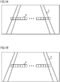
- FIGS. 1A and 1B are diagrams showing captured images in front of a vehicle in a traveling direction.
- FIGS. 1A and 1B depict pixels P and a traveling lane divided by dividing lines C.
- areas to be captured are different.
- a camera that captures the captured image of FIG. 1B is downwardly oriented than the camera that captures the captured image of FIG. 1A due to an influence of vibration or the like. Therefore, the captured image of FIG. 1A captures a farther side than the captured image of FIG. 1B .
- the image processing device calculates, for example, a size or length of a subject based on the number of pixels occupied by the subject in the captured image. As is seen from FIGS. 1A and 1B , the number of pixels corresponding to a lane width changes in a case where orientation of the camera is changed due to vibration or the like. As a result, the image processing device cannot calculate the correct lane width. In a case where the image processing device cannot calculate the correct lane width, for example, calculation accuracy of a curvature of a curve in which the vehicle travels is lowered, and the image processing device cannot effectively perform steering assistance during curve travel.
- the image processing device corrects a correlation between the length of the subject in the captured image and the number of pixels constituting the captured image. This makes it possible to improve accuracy of road information acquired by the vehicle using a camera or the like.
- a method of detecting a width of the lane is not limited to use of the camera as long as the width of the lane can be detected.
- the image processing device is described below with reference to FIG. 2 .
- FIG. 2 is a diagram showing a configuration of an image processing device 1 according to the embodiment.
- the image processing device 1 includes a storage unit 2, a control unit 3, a camera 4, and a global positioning system (GPS) sensor 5.
- the control unit 3 is, for example, an electronic control unit (ECU), and is connected to the storage unit 2 and the camera 4 in a wired or wireless manner.
- the camera 4 captures a road in front of the vehicle in the traveling direction.
- the GPS sensor 5 acquires position information on the vehicle.
- the storage unit 2 includes, for example, a Read Only Memory (ROM) in which a program executed by the control unit 3 is recorded and a Random Access Memory (RAM) that temporarily stores data.
- the ROM records map data including information on a width of a lane of a road on which the vehicle travels.
- the ROM also records magnitude of an error that serves as a criterion for correcting the correlation between the length of the subject in the captured image and the number of pixels constituting the captured image.
- the RAM records the corrected correlation between the length of the subject in the captured image and the number of pixels constituting the captured image.
- the RAM also records captured images captured by the camera 4.
- the storage unit 2 further may include a solid state drive (SSD), a hard disk drive (HDD), or the like, and the map data may be recorded in the SSD or the HDD.
- SSD solid state drive
- HDD hard disk drive
- the width of the lane can be calculated on a corrected scale even after an engine is stopped by recording the correlation between the length of the subject in the captured image and the number of pixels constituting the captured image in the same SSD or HDD after error correction.
- the control unit 3 functions as a lane-width calculation unit 6, a position information acquisition unit 7, a lane-width acquisition unit 8, and a scale correction unit 9 by executing the program stored in the storage unit 2.
- the lane-width calculation unit 6 acquires a captured image, in which a front of the vehicle in the traveling direction is captured, from the camera 4 and calculates a width of a lane in which the vehicle travels from the captured image. Specifically, for example, the lane-width calculation unit 6 counts the number of pixels present from a pixel on a dividing line to a pixel on another dividing line, as shown in FIG. 1 , and calculates the width of the lane based on a correlation between a predetermined number of pixels and a distance.
- the lane-width calculation unit 6 calculates the width of the lane as 3 m if there are 300 pixels between dividing lines in the captured image.
- the lane-width calculation unit 6 records the calculated width of the lane in the storage unit 2, and notifies the scale correction unit 9 of the width.
- the width of the lane may be arbitrarily defined.
- the lane-width calculation unit 6 may measure the lane width from outside of a dividing line having a thickness.
- the lane-width calculation unit 6 may measure the lane width from middle of a dividing line.
- the lane-width calculation unit 6 may measure the lane width from inside of a dividing line.
- a dividing line is detected, for example, based on a known method.
- the position information acquisition unit 7 acquires information indicating a position of the vehicle from the GPS sensor 5. After acquiring the information on the position of the vehicle, the position information acquisition unit 7 notifies the lane-width acquisition unit 8 of the acquired information.
- the lane-width acquisition unit 8 Based on the information indicating the position of the vehicle notified from the position information acquisition unit 7, the lane-width acquisition unit 8 acquires a width of the lane in which the vehicle travels from the map data recorded in the storage unit 2. The lane-width acquisition unit 8 records the width of the lane acquired from the map data in the storage unit 2 and notifies the scale correction unit 9 of the width.
- the scale correction unit 9 corrects a correlation between the length of the subject in the captured image and the number of pixels constituting the captured image.
- the predetermined value is, for example, the same as the thickness of the dividing line or 10 cm.
- the number of pixels present between dividing lines in FIG. 1B is 250, which corresponds to 1 cm per pixel.
- the lane-width calculation unit 6 calculates the width of the lane as 2.5 m. Meanwhile, in a case where the width of the lane acquired by the lane-width acquisition unit 8 from the map data is 3 m, an error between the width of the lane calculated by the lane-width calculation unit 6 and the width of the lane acquired by the position information acquisition unit 7 is 50 cm.
- the scale correction unit 9 corrects the correlation between the length of the subject in the captured image and the number of pixels constituting the captured image. In this case, the scale correction unit 9 corrects the correlation between the length of the subject in the captured image and the number of pixels constituting the captured image assuming, for example, 1.2 cm per pixel, and records the correlation in the storage unit 2.
- the predetermined value may be determined based on the width of the lane acquired by the lane-width acquisition unit 8 and a vehicle width. For example, the predetermined value may be small as a difference between the width of the lane acquired by the lane-width acquisition unit 8 and the vehicle width becomes small.
- the vehicle is likely to get out of the lane in a case where the difference between the width of the lane and the vehicle width is small. Therefore, in a case where the difference between the width of the lane and the vehicle width is small, the correlation between the length of the subject in the captured image and the number of pixels constituting the captured image is corrected even if the difference between the width of the lane calculated by the lane-width calculation unit 6 and the width of the lane acquired by the lane-width acquisition unit 8 from the map data is small. Accordingly, the image processing device 1 can detect the width of the lane with high accuracy and perform lane maintaining assistance more effectively.
- the predetermined value may be increased as the difference between the width of the lane acquired by the lane-width acquisition unit 8 and the vehicle width becomes large.
- the correlation between the length of the subject in the captured image and the number of pixels constituting the captured image is not corrected in a case where the difference between the width of the lane calculated by the lane-width calculation unit 6 and the width of the lane acquired by the lane-width acquisition unit 8 from the map data is small. Accordingly, chances that the scale correction unit 9 corrects the correlation between the length of the subject in the captured image and the number of pixels constituting the captured image are reduced. As a result, driving experience is improved since a driver enjoys the lane maintaining assistance that performs the same operation over a long period.
- the predetermined value may also be changed according to the thickness of the dividing line detected from the captured image.
- the predetermined value may be small as the dividing line is thin. In a case where the dividing line is thin, chances that the vehicle gets over the dividing line, that is, gets over the lane, increases. Therefore, in a case where the dividing line is thin, the image processing device 1 can effectively perform the lane maintaining assistance by correcting the correlation between the length of the subject in the captured image and the number of pixels constituting the captured image even in a case where the error is small.
- the scale correction unit 9 may correct the correlation between the length of the subject in the captured image and the number of pixels constituting the captured image. This is described with reference to FIG. 3 .
- FIG. 3 is a diagram in which widths of a lane calculated by the lane-width calculation unit 6 at each time point are plotted.
- a vertical axis indicates a width of the lane
- a horizontal axis indicates time.
- the width of the lane acquired by the lane-width acquisition unit 8 from the map data is represented by a solid line
- the predetermined value indicating an allowable error is represented by a width of the solid line and broken lines in FIG. 3 .
- the scale correction unit 9 corrects the correlation between the length of the subject in the captured image and the number of pixels constituting the captured image.
- the predetermined period is longer than a period considered for the vehicle to pass through a distorted place of the traveling road, for example, 5 seconds.
- the scale correction unit 9 does not correct the correlation between the length of the subject in the captured image and the number of pixels constituting the captured image, for example, in a case where the vehicle temporarily passes through a place where the road has deteriorated and the diving line deviates from an initially laid position. Therefore, it is possible to prevent the correlation between the length of the subject in the captured image and the number of pixels constituting the captured image from being erroneously corrected even if a position of a camera for capturing the captured image is not deviated.
- FIG. 4 is a flowchart showing a processing flow of the image processing device 1.
- the flowchart begins with the lane-width calculation unit 6 calculating the width of the lane based on the captured image (S41).
- the position information acquisition unit 7 acquires the position information on the vehicle (S42).
- the lane-width acquisition unit 8 acquires the width of the lane from the map data based on the position information on the vehicle (S43).
- the image processing device 1 starts the process again from S41.
- the scale correction unit 9 corrects the correlation between the length of the subject in the captured image and the number of pixels constituting the captured image.
- the image processing device 1 corrects the correlation between the length of the subject in the captured image and the number of pixels constituting the captured image.
- the image processing device 1 can improve accuracy of road information including the width and the curvature of the lane which is calculated based on the captured image or the like captured by the camera. As a result, the image processing device 1 can improve performance of the lane maintaining assistance of the vehicle.
- the present invention can improve accuracy of road information acquired by using a camera or the like.
Landscapes
- Engineering & Computer Science (AREA)
- Physics & Mathematics (AREA)
- Theoretical Computer Science (AREA)
- General Physics & Mathematics (AREA)
- Computer Vision & Pattern Recognition (AREA)
- Mathematical Physics (AREA)
- Mechanical Engineering (AREA)
- Transportation (AREA)
- Automation & Control Theory (AREA)
- Multimedia (AREA)
- Traffic Control Systems (AREA)
- Image Analysis (AREA)
- Image Processing (AREA)
Applications Claiming Priority (2)
| Application Number | Priority Date | Filing Date | Title |
|---|---|---|---|
| JP2016143002A JP6686760B2 (ja) | 2016-07-21 | 2016-07-21 | 画像処理装置及び画像処理方法 |
| PCT/JP2017/026327 WO2018016599A1 (ja) | 2016-07-21 | 2017-07-20 | 画像処理装置及び画像処理方法 |
Publications (2)
| Publication Number | Publication Date |
|---|---|
| EP3489899A1 true EP3489899A1 (de) | 2019-05-29 |
| EP3489899A4 EP3489899A4 (de) | 2019-07-17 |
Family
ID=60992615
Family Applications (1)
| Application Number | Title | Priority Date | Filing Date |
|---|---|---|---|
| EP17831115.5A Pending EP3489899A4 (de) | 2016-07-21 | 2017-07-20 | Bildverarbeitungsvorrichtung und bildverarbeitungsverfahren |
Country Status (5)
| Country | Link |
|---|---|
| US (1) | US10769815B2 (de) |
| EP (1) | EP3489899A4 (de) |
| JP (1) | JP6686760B2 (de) |
| CN (1) | CN109478336B (de) |
| WO (1) | WO2018016599A1 (de) |
Families Citing this family (3)
| Publication number | Priority date | Publication date | Assignee | Title |
|---|---|---|---|---|
| CN114174137A (zh) * | 2019-07-01 | 2022-03-11 | 哲内提 | Adas或ad特征的源横向偏移 |
| JP7067574B2 (ja) * | 2020-01-30 | 2022-05-16 | トヨタ自動車株式会社 | 距離推定装置及び距離推定用コンピュータプログラム |
| CN112529966B (zh) * | 2020-12-17 | 2023-09-15 | 豪威科技(武汉)有限公司 | 一种车载环视系统的在线标定方法及其车载环视系统 |
Family Cites Families (16)
| Publication number | Priority date | Publication date | Assignee | Title |
|---|---|---|---|---|
| JP3378490B2 (ja) | 1998-01-29 | 2003-02-17 | 富士重工業株式会社 | 道路情報認識装置 |
| JP4568637B2 (ja) * | 2005-04-26 | 2010-10-27 | 富士重工業株式会社 | 道路認識装置 |
| JP4610425B2 (ja) * | 2005-06-27 | 2011-01-12 | アルパイン株式会社 | 地図情報更新方法及びナビゲーション装置 |
| JP2007264712A (ja) * | 2006-03-27 | 2007-10-11 | Fuji Heavy Ind Ltd | 車線検出装置 |
| JP2007334450A (ja) * | 2006-06-12 | 2007-12-27 | Toyota Motor Corp | 車両用道路区画線認識装置、及び、車両用制御装置 |
| KR100933879B1 (ko) * | 2007-12-21 | 2009-12-28 | 팅크웨어(주) | 3d 지도 데이터 디스플레이 방법 및 상기 방법을 수행하기위한 장치 |
| EP2075170B1 (de) * | 2007-12-28 | 2011-02-16 | Magneti Marelli S.p.A. | Fahrassistenzsystem für ein Fahrzeug das auf einem Weg ohne Fahrspurabgrenzungslinien fährt |
| CN101776438B (zh) * | 2010-01-26 | 2013-04-24 | 武汉理工大学 | 道路标线测量装置及其测量方法 |
| EP2541498B1 (de) * | 2011-06-30 | 2017-09-06 | Harman Becker Automotive Systems GmbH | Verfahren zur Bestimmung der extrinsischen Parameter eines Farzeugsichtsystems und Fahrzeugsichtsystem |
| JP5645769B2 (ja) * | 2011-08-01 | 2014-12-24 | 株式会社日立製作所 | 画像処理装置 |
| JP5747787B2 (ja) * | 2011-11-04 | 2015-07-15 | トヨタ自動車株式会社 | 車線認識装置 |
| JP5926645B2 (ja) * | 2012-08-03 | 2016-05-25 | クラリオン株式会社 | カメラパラメータ演算装置、ナビゲーションシステムおよびカメラパラメータ演算方法 |
| JP6173791B2 (ja) * | 2013-06-25 | 2017-08-02 | 株式会社東芝 | 道路状況把握システム、及び道路状況把握装置 |
| JP6172020B2 (ja) * | 2014-03-28 | 2017-08-02 | 株式会社デンソー | 無余地駐車抑止装置 |
| CN104657727B (zh) * | 2015-03-18 | 2018-01-02 | 厦门麦克玛视电子信息技术有限公司 | 一种车道线的检测方法 |
| CN105678316B (zh) * | 2015-12-29 | 2019-08-27 | 大连楼兰科技股份有限公司 | 基于多信息融合的主动驾驶方法 |
-
2016
- 2016-07-21 JP JP2016143002A patent/JP6686760B2/ja active Active
-
2017
- 2017-07-20 US US16/318,932 patent/US10769815B2/en active Active
- 2017-07-20 EP EP17831115.5A patent/EP3489899A4/de active Pending
- 2017-07-20 WO PCT/JP2017/026327 patent/WO2018016599A1/ja unknown
- 2017-07-20 CN CN201780044971.8A patent/CN109478336B/zh active Active
Also Published As
| Publication number | Publication date |
|---|---|
| CN109478336B (zh) | 2022-05-10 |
| EP3489899A4 (de) | 2019-07-17 |
| CN109478336A (zh) | 2019-03-15 |
| US20190259179A1 (en) | 2019-08-22 |
| WO2018016599A1 (ja) | 2018-01-25 |
| JP2018013956A (ja) | 2018-01-25 |
| JP6686760B2 (ja) | 2020-04-22 |
| US10769815B2 (en) | 2020-09-08 |
Similar Documents
| Publication | Publication Date | Title |
|---|---|---|
| JP4962581B2 (ja) | 区画線検出装置 | |
| RU2662411C2 (ru) | Способ калибровки камеры | |
| JP6466811B2 (ja) | 走行区画線認識装置 | |
| EP3040254B1 (de) | Drehwinkelkorrekturverfahren, drehwinkelkorrekturvorrichtung, bilderfassungsvorrichtung und drehwinkelkorrektursystem | |
| US10769815B2 (en) | Image processing device and image processing method | |
| JP4670528B2 (ja) | 撮像装置のずれ検出方法、撮像装置のずれ補正方法及び撮像装置 | |
| CN110431609B (zh) | 车辆位置推定装置 | |
| US20220254064A1 (en) | External parameter calibration method, device and system for image acquisition apparatus | |
| JP2014115247A (ja) | 車両位置推定装置およびセンサ情報統合装置 | |
| JP2009002754A (ja) | 停止判断装置、ナビゲーション装置、停止判断方法、停止判断プログラムおよび記録媒体 | |
| JP2007181129A (ja) | 車載用移動体検出装置 | |
| CN113306559A (zh) | 在路形估计中对于垂直道路曲度的补偿 | |
| JP2008082925A (ja) | ナビゲーション装置、その制御方法及び制御プログラム | |
| CN110570680A (zh) | 利用地图信息确定对象位置的方法和系统 | |
| JP5142801B2 (ja) | オフセット補正装置およびオフセット補正方法 | |
| JP4225242B2 (ja) | 走行路認識装置 | |
| JP6023025B2 (ja) | 舵角補正方法、舵角補正装置、撮像装置、および舵角補正システム | |
| JP7027006B2 (ja) | 走行車線認識装置、走行車線認識方法及びプログラム | |
| JP2011055342A (ja) | 車両用撮像装置 | |
| JP4196211B2 (ja) | 画像処理装置及び画像処理方法 | |
| JP2019100970A (ja) | 自己位置誤差推定装置及び自己位置誤差推定方法 | |
| JP5056436B2 (ja) | 三次元地図生成装置、及びプログラム | |
| WO2020241125A1 (ja) | 立柱検出装置及び立柱検出方法 | |
| JP2010011311A (ja) | 車両用撮影装置および撮影方法 | |
| JP2009212703A (ja) | 車載カメラシステム |
Legal Events
| Date | Code | Title | Description |
|---|---|---|---|
| STAA | Information on the status of an ep patent application or granted ep patent |
Free format text: STATUS: THE INTERNATIONAL PUBLICATION HAS BEEN MADE |
|
| PUAI | Public reference made under article 153(3) epc to a published international application that has entered the european phase |
Free format text: ORIGINAL CODE: 0009012 |
|
| STAA | Information on the status of an ep patent application or granted ep patent |
Free format text: STATUS: REQUEST FOR EXAMINATION WAS MADE |
|
| 17P | Request for examination filed |
Effective date: 20190221 |
|
| AK | Designated contracting states |
Kind code of ref document: A1 Designated state(s): AL AT BE BG CH CY CZ DE DK EE ES FI FR GB GR HR HU IE IS IT LI LT LU LV MC MK MT NL NO PL PT RO RS SE SI SK SM TR |
|
| AX | Request for extension of the european patent |
Extension state: BA ME |
|
| A4 | Supplementary search report drawn up and despatched |
Effective date: 20190619 |
|
| RIC1 | Information provided on ipc code assigned before grant |
Ipc: G06T 7/80 20170101AFI20190613BHEP Ipc: B60R 11/04 20060101ALI20190613BHEP Ipc: G06T 7/00 20170101ALI20190613BHEP Ipc: B60W 40/11 20120101ALI20190613BHEP |
|
| DAV | Request for validation of the european patent (deleted) | ||
| DAX | Request for extension of the european patent (deleted) | ||
| STAA | Information on the status of an ep patent application or granted ep patent |
Free format text: STATUS: EXAMINATION IS IN PROGRESS |
|
| 17Q | First examination report despatched |
Effective date: 20200212 |
|
| STAA | Information on the status of an ep patent application or granted ep patent |
Free format text: STATUS: EXAMINATION IS IN PROGRESS |
|
| STAA | Information on the status of an ep patent application or granted ep patent |
Free format text: STATUS: EXAMINATION IS IN PROGRESS |