EP3458876B1 - Positionsschätzung in einem satellitenkommunikationssystem mit niedriger erdumlaufbahn - Google Patents
Positionsschätzung in einem satellitenkommunikationssystem mit niedriger erdumlaufbahn Download PDFInfo
- Publication number
- EP3458876B1 EP3458876B1 EP17798378.0A EP17798378A EP3458876B1 EP 3458876 B1 EP3458876 B1 EP 3458876B1 EP 17798378 A EP17798378 A EP 17798378A EP 3458876 B1 EP3458876 B1 EP 3458876B1
- Authority
- EP
- European Patent Office
- Prior art keywords
- satellite
- terminal
- transmission
- time
- doppler frequency
- Prior art date
- Legal status (The legal status is an assumption and is not a legal conclusion. Google has not performed a legal analysis and makes no representation as to the accuracy of the status listed.)
- Active
Links
Images


Classifications
-
- G—PHYSICS
- G01—MEASURING; TESTING
- G01S—RADIO DIRECTION-FINDING; RADIO NAVIGATION; DETERMINING DISTANCE OR VELOCITY BY USE OF RADIO WAVES; LOCATING OR PRESENCE-DETECTING BY USE OF THE REFLECTION OR RERADIATION OF RADIO WAVES; ANALOGOUS ARRANGEMENTS USING OTHER WAVES
- G01S19/00—Satellite radio beacon positioning systems; Determining position, velocity or attitude using signals transmitted by such systems
- G01S19/01—Satellite radio beacon positioning systems transmitting time-stamped messages, e.g. GPS [Global Positioning System], GLONASS [Global Orbiting Navigation Satellite System] or GALILEO
- G01S19/13—Receivers
- G01S19/24—Acquisition or tracking or demodulation of signals transmitted by the system
- G01S19/28—Satellite selection
-
- G—PHYSICS
- G01—MEASURING; TESTING
- G01S—RADIO DIRECTION-FINDING; RADIO NAVIGATION; DETERMINING DISTANCE OR VELOCITY BY USE OF RADIO WAVES; LOCATING OR PRESENCE-DETECTING BY USE OF THE REFLECTION OR RERADIATION OF RADIO WAVES; ANALOGOUS ARRANGEMENTS USING OTHER WAVES
- G01S19/00—Satellite radio beacon positioning systems; Determining position, velocity or attitude using signals transmitted by such systems
- G01S19/01—Satellite radio beacon positioning systems transmitting time-stamped messages, e.g. GPS [Global Positioning System], GLONASS [Global Orbiting Navigation Satellite System] or GALILEO
- G01S19/03—Cooperating elements; Interaction or communication between different cooperating elements or between cooperating elements and receivers
- G01S19/09—Cooperating elements; Interaction or communication between different cooperating elements or between cooperating elements and receivers providing processing capability normally carried out by the receiver
-
- G—PHYSICS
- G01—MEASURING; TESTING
- G01S—RADIO DIRECTION-FINDING; RADIO NAVIGATION; DETERMINING DISTANCE OR VELOCITY BY USE OF RADIO WAVES; LOCATING OR PRESENCE-DETECTING BY USE OF THE REFLECTION OR RERADIATION OF RADIO WAVES; ANALOGOUS ARRANGEMENTS USING OTHER WAVES
- G01S19/00—Satellite radio beacon positioning systems; Determining position, velocity or attitude using signals transmitted by such systems
- G01S19/38—Determining a navigation solution using signals transmitted by a satellite radio beacon positioning system
- G01S19/39—Determining a navigation solution using signals transmitted by a satellite radio beacon positioning system the satellite radio beacon positioning system transmitting time-stamped messages, e.g. GPS [Global Positioning System], GLONASS [Global Orbiting Navigation Satellite System] or GALILEO
- G01S19/42—Determining position
- G01S19/45—Determining position by combining measurements of signals from the satellite radio beacon positioning system with a supplementary measurement
- G01S19/46—Determining position by combining measurements of signals from the satellite radio beacon positioning system with a supplementary measurement the supplementary measurement being of a radio-wave signal type
-
- G—PHYSICS
- G01—MEASURING; TESTING
- G01S—RADIO DIRECTION-FINDING; RADIO NAVIGATION; DETERMINING DISTANCE OR VELOCITY BY USE OF RADIO WAVES; LOCATING OR PRESENCE-DETECTING BY USE OF THE REFLECTION OR RERADIATION OF RADIO WAVES; ANALOGOUS ARRANGEMENTS USING OTHER WAVES
- G01S19/00—Satellite radio beacon positioning systems; Determining position, velocity or attitude using signals transmitted by such systems
- G01S19/38—Determining a navigation solution using signals transmitted by a satellite radio beacon positioning system
- G01S19/39—Determining a navigation solution using signals transmitted by a satellite radio beacon positioning system the satellite radio beacon positioning system transmitting time-stamped messages, e.g. GPS [Global Positioning System], GLONASS [Global Orbiting Navigation Satellite System] or GALILEO
- G01S19/42—Determining position
- G01S19/48—Determining position by combining or switching between position solutions derived from the satellite radio beacon positioning system and position solutions derived from a further system
-
- G—PHYSICS
- G01—MEASURING; TESTING
- G01S—RADIO DIRECTION-FINDING; RADIO NAVIGATION; DETERMINING DISTANCE OR VELOCITY BY USE OF RADIO WAVES; LOCATING OR PRESENCE-DETECTING BY USE OF THE REFLECTION OR RERADIATION OF RADIO WAVES; ANALOGOUS ARRANGEMENTS USING OTHER WAVES
- G01S5/00—Position-fixing by co-ordinating two or more direction or position line determinations; Position-fixing by co-ordinating two or more distance determinations
- G01S5/0009—Transmission of position information to remote stations
-
- G—PHYSICS
- G01—MEASURING; TESTING
- G01S—RADIO DIRECTION-FINDING; RADIO NAVIGATION; DETERMINING DISTANCE OR VELOCITY BY USE OF RADIO WAVES; LOCATING OR PRESENCE-DETECTING BY USE OF THE REFLECTION OR RERADIATION OF RADIO WAVES; ANALOGOUS ARRANGEMENTS USING OTHER WAVES
- G01S5/00—Position-fixing by co-ordinating two or more direction or position line determinations; Position-fixing by co-ordinating two or more distance determinations
- G01S5/0009—Transmission of position information to remote stations
- G01S5/0018—Transmission from mobile station to base station
- G01S5/0036—Transmission from mobile station to base station of measured values, i.e. measurement on mobile and position calculation on base station
-
- H—ELECTRICITY
- H04—ELECTRIC COMMUNICATION TECHNIQUE
- H04B—TRANSMISSION
- H04B7/00—Radio transmission systems, i.e. using radiation field
- H04B7/14—Relay systems
- H04B7/15—Active relay systems
- H04B7/185—Space-based or airborne stations; Stations for satellite systems
- H04B7/195—Non-synchronous stations
-
- H—ELECTRICITY
- H04—ELECTRIC COMMUNICATION TECHNIQUE
- H04W—WIRELESS COMMUNICATION NETWORKS
- H04W4/00—Services specially adapted for wireless communication networks; Facilities therefor
- H04W4/02—Services making use of location information
-
- H—ELECTRICITY
- H04—ELECTRIC COMMUNICATION TECHNIQUE
- H04W—WIRELESS COMMUNICATION NETWORKS
- H04W4/00—Services specially adapted for wireless communication networks; Facilities therefor
- H04W4/02—Services making use of location information
- H04W4/024—Guidance services
-
- H—ELECTRICITY
- H04—ELECTRIC COMMUNICATION TECHNIQUE
- H04W—WIRELESS COMMUNICATION NETWORKS
- H04W4/00—Services specially adapted for wireless communication networks; Facilities therefor
- H04W4/02—Services making use of location information
- H04W4/029—Location-based management or tracking services
-
- G—PHYSICS
- G01—MEASURING; TESTING
- G01S—RADIO DIRECTION-FINDING; RADIO NAVIGATION; DETERMINING DISTANCE OR VELOCITY BY USE OF RADIO WAVES; LOCATING OR PRESENCE-DETECTING BY USE OF THE REFLECTION OR RERADIATION OF RADIO WAVES; ANALOGOUS ARRANGEMENTS USING OTHER WAVES
- G01S5/00—Position-fixing by co-ordinating two or more direction or position line determinations; Position-fixing by co-ordinating two or more distance determinations
- G01S5/02—Position-fixing by co-ordinating two or more direction or position line determinations; Position-fixing by co-ordinating two or more distance determinations using radio waves
- G01S5/12—Position-fixing by co-ordinating two or more direction or position line determinations; Position-fixing by co-ordinating two or more distance determinations using radio waves by co-ordinating position lines of different shape, e.g. hyperbolic, circular, elliptical or radial
-
- H—ELECTRICITY
- H04—ELECTRIC COMMUNICATION TECHNIQUE
- H04B—TRANSMISSION
- H04B7/00—Radio transmission systems, i.e. using radiation field
- H04B7/14—Relay systems
- H04B7/15—Active relay systems
- H04B7/185—Space-based or airborne stations; Stations for satellite systems
- H04B7/18523—Satellite systems for providing broadcast service to terrestrial stations, i.e. broadcast satellite service
Definitions
- the present disclosure relates to estimation of the position of a ground-based transceiver in a satellite communications system.
- the present disclosure relates systems in which estimation is performed remote from the terminal.
- This application is directed to satellite communications system 1 that is comprised of ground-based transceivers, referred to as terminals 10, transmitting data 12 using radio signals to one or more low-earth-orbiting satellites 20. These satellites transmit signals 22 to relay the terminals' radio signals to ground stations 30 where the received signals 22 are decoded and delivered to the destination.
- satellite communications system 1 that is comprised of ground-based transceivers, referred to as terminals 10, transmitting data 12 using radio signals to one or more low-earth-orbiting satellites 20.
- These satellites transmit signals 22 to relay the terminals' radio signals to ground stations 30 where the received signals 22 are decoded and delivered to the destination.
- Example applications include tracking of remote, and potentially mobile assets, such as livestock, industrial machinery, shipping containers, palettes, and environmental sensors. These are applications in which the asset or sensor itself does not need to know its own position. Rather a central management system wishes to determine the location of all the assets/sensors. Such applications can be contrasted with navigation applications, where the terminal itself requires estimates of its own location.
- terminals 10 can be fitted with GPS receivers which can be used to transmit their location to the Ground station 30 (via LEO satellite 20), adding a GPS module/receiver adds to both the costs and power requirements.
- GPS modules require significant computational resources to estimate position, and additionally the GPS module must have up-to-date satellite ephemeris data. This typically requires the GPS module to periodically wake up and acquire the latest GPS almanac. In cold start it takes a GPS receiver 12 minutes to download the full almanac placing significant burden on power requirements for the terminal.
- Assisted GPS systems can be used to reduce the computational burden or power requirements on the terminals by transmitting recent almanac information to terminals, and/or by allowing terminals to sample the GPS signal and to transmit the samples to a more capable processing device.
- this requires the terminal to be capable of establishing a communication link with sufficient capabilities to send the samples over a communications channel between the terminal and the more capable processing device. In applications with remote terminals 10 as discussed above, this requirement can add significant cost and power requirements to terminals 10.
- EP0845874A2 "Geolocation method and apparatus for satellite based telecommunications systems" describes several method for determining the geolocation of a mobile terminal within a telecommunications satellite system.
- the satellites operate as bent pipe mode immediately relaying signals received on an uplink onto a downlink without delay. Additionally the earth stations transmits time and frequency corrections to the terminals to ensure synchronisation of the terminals with the earth station.
- the known location of the satellite is used to estimate the satellite to terminal time delay and a frequency offset if calculated from the difference between the received and reference carrier frequencies. Range and Doppler solution lines are generate and the position is estimated based on their intersection.
- a second method which provides greater accuracy
- two earth stations and two satellites are used in cooperation to calculate the geolocation.
- a disadvantage of both methods is that they rely on instantaneous relaying of signals by the satellites, accurate knowledge of the satellite position, and synchronisation of the terminal with the earth station which requires the terminals to actively listen for satellite signals which can waste power. Accordingly the methods are unsuitable for use in systems with low power terminals or for systems using uncontrolled or minimally controlled satellites (such as a cubesats) or where satellites do not have a persistent real-time connection to a ground station.
- YABUMOTO et al "A differential positioning scheme with a single satellite to be incorporated into mobile communications", Electronics and Communications in Japan (Part I: Communications), Volume79, Issue3, 1996, Pages 73-82, XP000583432 , which determines a position of a terminal by estimating a range between a mobile terminal and a satellite at two different times.
- a ground station measures the station to satellite distance at the same times based on known station and satellite positions and this is used to estimate a range error. The procedure is repeated and the range error used as a correction value.
- the optimal time period for obtaining a position accuracy of 100m was 100s if the satellite was at an altitude of 1000km, and around 40s for a position accuracy of 500m. Accordingly this system is unsuitable for use in systems with low power terminals or for systems using uncontrolled or minimally controlled satellites (such as a cubesats) or where satellites do not have a persistent real-time connection to a ground station.
- EP0856957 A2 describes a communications satellite communications system and method, where a communications satellite 10 can pass messages between a user terminal 44 and an earth station 38, as the communications satellite moves in an orbit 12 12' as indicated by arrow 46, comprises means for estimating the position of the user terminal 44, on the surface of the earth 14, relative to the nadir 50, by means of doppler shift measurements and propagation delay measurements between the communications satellite 10 and the user terminal 44. Where more than one communications satellite 10 is visible to the user terminal 44, combination means are employed using propagation delays to plural communications satellites 10, and/or recordal of the receipt times, by the user terminal 44, of timed broadcasts from one or more communications satellites 10 to determine the propagation delay between the one or more communications satellites 10 and the user terminal 44.
- delay signals from navigational satellites 142 can be processed by the user terminal 44 measuring the time of arrival of signals from the navigational satellites 142 and conveying the identity of the navigational satellite and the arrival time of the signal to the earth station, which calculates the position of the user terminal 44 and can relay an indication thereof back to the user terminal 44.
- EP0941486 A1 describes a system and method for determining the position of a user terminal (for example, a mobile wireless telephone) in a low-Earth orbit satellite communications system.
- the system includes a user terminal, at least one satellite with a known position and velocity, and a gateway (that is, a terrestrial base station) for communicating with the user terminal through the satellites.
- the method includes the steps of determining a range parameter and a range-rate parameter.
- a range parameter represents a distance between the satellite and the user terminal.
- a range-rate parameter represents a relative radial velocity between that satellite and the user terminal.
- the position of the user terminal on the Earth's surface is then determined based on the range parameter, the range-rate parameter, and the known position and velocity of the satellite.
- a method for estimation of the position of a ground-based terminal in a satellite communications system comprising:
- the information may be one or more digital samples of the transmitted signal which are transmitted to the ground station or the information may be the retransmitted analog signal received by the satellite retransmitted to the ground station (ie bent pipe satellite).
- information relating to a transmission between a terminal and the satellite further comprises a time stamp that the transmission was received by the satellite with respect to an on board time or frequency reference, and/or a time stamp that the transmission was transmitted by the terminal with respect to a time or frequency reference.
- information relating to a transmission between a terminal and the satellite further comprises an estimated transmission time by the terminal based on a predetermined transmission schedule determined against the terminals time or frequency reference.
- the terminal transmits a sequence of transmissions to the satellite, and the satellite transmits information relating to the sequence of transmissions to the ground station, and estimating one or more of a delay, Doppler or Doppler rate from the received information is performed for each transmission in the sequence of transmissions, and estimating the terminal position uses the estimate of the satellite's position at the time of each transmission, and each of the estimates for each transmission in the sequence of transmissions.
- estimating the terminal position is performed differentially on the difference between estimates between transmissions in the sequence of transmissions. This may be performed in cases where the on-board time or frequency reference is not synchronised to any global time or frequency reference and/or the satellite does not include an on-board position reference and/or the terminal is not synchronised to any global time or frequency reference.
- the terminal comprises a stable clock and is not synchronised to any global time or frequency reference and the estimating the terminal position further comprises estimating a terminal offset with respect to a global time or frequency reference.
- the satellite does not include an on-board position reference, and estimation of the terminal position further comprises estimating the satellite position.
- the method further comprises: receiving, at the satellite, one or more beacon signals from a terrestrial or space based source, the beacon signal comprising the beacons position and global timing with respect to a reference, and the satellite forwards samples of the signal to the ground station, and estimating the location of the terminal further comprises estimating at least one of a beacon delay, a beacon Doppler or a beacon Doppler rate for each beacon signal. This estimate can be used to improve the estimate of the satellite position and thus the terminal position.
- the method further comprises: receiving, at the terminal, one or more beacon signals from a terrestrial or space based source, the beacon signal comprising the beacons position and global timing with respect to a reference, and the terminal estimating one or more of a beacon Doppler or a beacon Doppler rate for each beacon signal, and including the estimates in one or more transmissions to the satellite, and estimating the location of the terminal further comprises estimating at least one of a beacon delay, a beacon Doppler or a beacon Doppler rate for each beacon signal.
- the position estimating is performed using non-linear optimisation process for the time-varying position vector of the satellite based on a hypothesis of the position vector of the terminal at a time t.
- the method further comprises estimating the footprint of the satellite, and constraining the position vector of the terminal to be within the footprint.
- the terminal is configured to receive GPS L1 signals and performs coarse estimation of the "phase" (delay) of the C/A code and the Doppler frequency and to provide the estimates of the C/A code and Doppler frequency in one or more transmissions to the satellite, and the step of estimating the terminal position further comprises receiving a GPS almanac and using the received estimates of the C/A code and Doppler frequency to estimate the position of the terminal.
- the terminal obtains estimates of the C/A code and Doppler frequency by:
- a communications receiver included in or operatively connected to a ground station for estimation of the position of a ground-based terminal in a satellite communications system comprising:
- the communications receiver may be further configured to perform the further forms of the method of the first aspect.
- a communication system and terminals may also be provided which are configured to perform the method of the first aspect.
- the method may also be provided in a processor readable medium for configuring a process to perform the method of the first aspect.
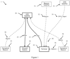
- FIG 1 is a schematic diagram of a low earth orbit satellite communications system according to an embodiment illustrating the broad system components and signal paths.
- the satellite communications system 1 is comprised of ground-based transceivers, referred to as terminals 10, transmitting data 12 using radio signals to one or more low-earth-orbiting satellites 20. These satellites transmit signals 22 to relay the terminals' radio signals to ground stations 30 where the received signals 22 are decoded and delivered to the destination.
- Figure 2 is a more detailed schematic representation of this system showing various modules for performing position estimation from Doppler and delay estimates as described herein.
- Embodiments of the system and method obtain a location estimate from measurements derived from the time-of flight (transmission path length from the terminal to the satellite), relative Doppler frequency (first derivative of path length), and rate of change of Doppler frequency (second derivative of path length) of the terminal's transmitted signals 12 as seen by a low-earth-orbiting (LEO) satellite 20.
- the time of flight is the time delay between transmission and reception of the signal, and thus will be referred to as the delay (or time delay).
- the relative Doppler frequency and rate of change of Doppler frequency will be referred to as Doppler and Doppler rate.
- Embodiments of the method can optionally uses a sequence of such measurements, in which case these measurements do not need to be with respect to an absolute time or frequency reference, but can be differential, with respect to a particular chosen reference (e.g. the time and frequency of the first measurement).
- the information relating to a transmission between (or from) a terminal and the satellite may be one or more digital samples of the transmitted signal (received at the satellite) which are then transmitted to the ground station or the information may be the retransmitted analog signal received by the satellite retransmitted to the ground station (ie bent pipe satellite).
- the information (or signals, or samples) is then provided to a communications receiver that performs an estimation process (described in detail below) which includes estimation of the delay, Doppler and/or Doppler rate.
- the information relating to a transmission between a terminal and the satellite may also include a time stamp of the time that the transmission was received by the satellite with respect to an on board time or frequency reference.
- this time or frequency reference can be synchronised to a global reference, or may be an unsynchronised but stable time or frequency reference.
- the information may comprise a time stamp that the transmission was transmitted by the terminal with respect to a time or frequency reference in the terminal (that is the terminal adds this time stamp when transmitting). Again this may be synchronised to a global reference or it may be unsynchronised.
- the terminal does not time stamp its transmission but instead transmits based on a predetermined transmission schedule determined against the terminals time or frequency reference.
- the terminals schedule will be known by the position estimation module at the ground station.
- the time stamp information may be embedded in the transmission, and become available once the transmission is decoded and recovered, or it may be provided as an additional or side transmission from the satellite to the ground station.
- the information relating to a transmission between a terminal and the satellite comprises the signal or sample(s) of the signal, and any metadata recoverable from the signal or sample, or sent along with the signal.
- a position estimator 40 at the ground station 30 works by comparing the estimates of the terminal's delay/Doppler/Doppler rate, computed at the ground station 30 to the corresponding hypothesised quantities that would be expected for a particular hypothesis for the terminal's location. These quantities can be determined knowing the satellite's position 20, an accurate estimate of which is available (either obtainable from another source or estimatable based on available/obtainable data) to the ground station. The location estimate is the hypothesis with the smallest total error between the estimated and hypothesised quantities. Typically estimation of the delay, Doppler and Doppler rate will also include estimation of errors in these quantities.
- This error (or uncertainty) can also be passed to the position estimator, and used in the position estimation process, such as by appropriately weighting estimates based on the error. Whilst only one of delay, Doppler or Doppler rate is required, performance will typically be improved if the estimates of two or all three values are provided.
- FIG. 5 is a flowchart 500 of a method for estimation of the position of a ground-based terminal in a satellite communications system according to an embodiment. The method comprises:
- Embodiments of the method can additionally and optionally opportunistically exploit other beacon signals 50 received by the terminal.
- These beacon signals 50 may be a beacon signal 52 from a beacon satellite 51, the GPS L1 signal 54 from a Global Positioning System (GPS) satellite 53, or a beacon signal 56 from a terrestrial beacon 55.
- GPS Global Positioning System
- beacon signals 50 it is required:
- the terminal 10 computes or otherwise estimates one or more of the delay/Doppler/Doppler rate estimates for a beacon signal (or beacon signals), and then transmits the estimate(s) of such beacon signals 50 as part of its data transmission 12 to the low earth orbit satellite 20.
- the position estimator compares the terminal computed estimates with their corresponding hypothetical values to refine the terminal position estimate. This process is described in more detail in Section 2 below.
- the location of the low earth orbit satellite may not be precisely known a-priori at the ground station.
- terrestrial beacons can be optionally exploited to improve the ground station's estimate of the satellite position.
- the low earth orbit satellite additionally samples the terrestrial beacon signals and relays these samples to the ground station.
- the ground station can then use estimates of the delay/Doppler/Doppler rate of these signals to estimate, or to improve its estimate of the position of the satellite.
- the terrestrial beacons could be special instances of the general population of terminals, having trusted known locations (e.g. they may be equipped with standard GPS modules from which they derive their precise position and send it to the ground station).
- the beacons could be signals of opportunity, transmitted from known locations (e.g. terrestrial radio or television broadcasts).
- the method described herein is also independently applicable to low earth orbit satellites with and without on-board global position and timing references:
- Figure 2 is a detailed schematic representation of a system 2 for position estimation from Doppler and delay estimates according to an embodiment.
- the system consists of a remote user terminal 10, transmitting a sequence of packets of data 12 containing user data via a satellite payload 24 in low earth orbit to a ground station 30.
- ECI Earth Centered Inertial
- the terminal 10 receives user data 112, for example from a sensor module integrated with or connected to the terminal (not shown) and/or identification data 114 such as a unique terminal identifier number, which may be stored in a memory.
- a packet formatting module 110 receives the user data 112 and identification data 114 and generates message bits 116.
- a transmitter IQ waveform generator 120 receives the message bits 116 and slot timing information 122 to generate transmitter IQ samples 124.
- a digital to analog (DAC) converter 130 provides analog signals to the RF transceiver front end 140 which transmits a signal 12 via antenna 142.
- the RF transceiver front end 140 may be a wideband transceiver front end.
- a Low Earth Orbit Satellite 20 includes a satellite payload 24 which has a RF front end 25 which receives the signal 12 transmitted from the terminal 10.
- the underlying quantities of interest are d ( t ) , and its first and second order time derivatives: d '( t ) and d "( t ).
- the choice of coordinates is arbitrary.
- delay, Doppler and Doppler rate we will refer to delay, Doppler and Doppler rate, but the method would work equally using distance, velocity and acceleration, or any other invertible transformation of these quantities.
- references to delay, Doppler, and Doppler rate is to encompass equivalent quantities obtained from invertible transformation of these quantities.
- the satellite payload 24 samples the relevant radio frequency band via RF front end 25 (using a bandwidth that is wide enough to capture terminal transmissions allowing for Doppler shift) and an analog to Digital (ADC) converter 26 that provides spectrum samples 27 to a downlink transceiver 28 for transmission to the ground station 30.
- ADC analog to Digital
- the information relating to a transmission between a terminal and a satellite includes at least these spectrum samples.
- the information may additionally include any other metadata such as time stamps which may be added or separately transmitted to the ground station.
- the satellite If the satellite has access to a precise global time reference (for example obtained from the Global Positioning System), it timestamps these digitised samples 27 and a downlink transceiver 28 relays them using a digital communications link 22, which may be on a different frequency and of a different bandwidth, to a ground station 30.
- the ground station 30 forwards these digital samples to a communications receiver 32 for processing.
- the communications receiver 32 may or may not be co-located with the ground station 30.
- other satellite payloads configuration which can relay the terminal signal 12 to the ground station 30 can be used. Note that the satellite can relay the signal 12 in real time if the ground station is within the field of view of the satellite 20, or store and forward received signals 12 at a later time when the ground station is within the field of view of the satellite 20.
- the communications receiver 32 decodes the sequence of terminal packets from the received spectrum samples.
- the primary goal of the decoding process is to obtain or recover an estimate of the user data 112.
- the communications receiver also produces an associated estimate of the Doppler shift ⁇ 0 j , Doppler rate ⁇ 0 j , and delay ⁇ 0 j 34.
- These estimates 34 are all relative to a precise, stable time reference, which may or may not be the same reference available to the satellite, ground station or position processor (this will be elaborated below).
- the subscript 0 is used to identify these estimates 34 with the low earth orbit satellite, and this subscript will be used later to discriminate between quantities relevant to other satellites (i.e. this will later index a list of available beacon satellites and/or terrestrial beacons).
- module encompasses hardware such as application specific integrated circuits (ASICs), digital signal processors (DSPs), digital signal processing devices (DSPDs), programmable logic devices (PLDs), or field programmable gate arrays (FPGAs) which are configured to implement the method, or a processor board with a processor and associated memory (on board or operatively linked) storing executable instructions to implement the method, along with other supporting components (power supplies, data buses, communications boards or chips, etc).
- ASICs application specific integrated circuits
- DSPs digital signal processors
- DSPDs digital signal processing devices
- PLDs programmable logic devices
- FPGAs field programmable gate arrays
- module and processor will be used interchangeably in which case processor should be interpreted broadly as a processor unit and associated hardware and software.
- TLE Two Line Elements
- the position estimation processor 40 can exploit the fact that the ⁇ 0 j , ⁇ 0 j , ⁇ 0 j 34 are "absolute", i.e. are with respect to a known reference.
- the position estimation processor can instead exploit the stability of these estimates from different packets, i.e. can compare time and/or frequency estimates between packets with different index j.
- the position estimator 40 can determine at least an approximation of the time-varying position vector x s ( t ) of the low earth orbit satellite.
- x t ( t ) be a hypothesis for the position vector of the terminal at time t (in the same coordinate system as x s ( t )). For simplicity we will for the moment assume x t ( t ) ⁇ x t for the time interval ( t 0 , t J -1 ).
- the "footprint" of the satellite can be determined. This is the set of positions X ( t ) on the earth from which (in the absence of obstructions) the satellite is visible. This represents the feasible set of choices for the terminal position at time t, i.e. we know that x t ⁇ X ( t ). This footprint can easily be modified to account for small uncertainties in the satellite position, timing, and minimum elevation angles required for communication with the satellite.
- X ⁇ j X ( t j ) .
- Terrestrial or space-based beacon signals 58 that can be received by the low earth orbit satellite 20 can be used to improve performance by improving position estimates of the low earth orbit satellite. This is described in Section 3.1.
- Beacon signals 50 can also be received by the terminal and used to improve position estimates 42. This is described in Section 3.2.
- the terminal 10 has time and frequency synchronisation, such that the estimates ⁇ 0 j , and ⁇ 0 j are with respect to ⁇ c and ⁇ 0 j is with respect to the precise time t j of the transmission of packet j (i.e. is an estimate of the time-of-flight ⁇ ( t j ).
- ⁇ 0 j , ⁇ 0 j are non-negative constants which are used to weight the contributions to the global error function. These constants can be used to tune the system performance and can be determined ahead of time by experiment, and may include change of unit factors to transform values to more comparable values.
- estimation may be performed using other functions or optimisation methods.
- a linear least squares approach could be used or hybrid solutions that use a linear method as a first estimate, and a non-linear method to further refine this estimate (or vice versa).
- other methods including iterative methods that seek to minimise the errors, for example by defining a function and minimising or maximising that function.
- the estimation process need to be guaranteed to be the optimal solution, but may be defined by satisfying a precision or stability based stopping criteria such as error less than a predetermined threshold, or the change between successive iterations or a sequence of iterations being less than a predetermined threshold.
- ambiguities in the absence of any other information concerning the terminal position, there may be unresolvable ambiguities. By this we mean that there will be two candidate terminal positions belonging to X that have the same minimal ⁇ ( x t ). In some cases such ambiguities can be resolved by employing additional information about the terminal position which may be known a-priori. For example, the approximate position of the terminal may already be known for example from a previously obtained position fix, and this information can be used to rule out the incorrect ambiguity.
- Section 3.1 describes how to use such signals received by the low earth orbit satellite.
- the position estimator 40 In order to obtain accurate position estimates of the terminal 10, it is important that the position estimator 40 has precise knowledge of the position of the satellite 20. Estimates derived from TLE data may not be sufficiently accurate in practice.
- the satellite can additionally sample beacon signals 50 transmitted from space-based or terrestrial sources 51, 53, 55.
- the low earth orbit satellite 20 to carry a GPS receiver payload, and to receive GPS signals to determine its position very accurately, and relay this information to the ground station 30. This may not be desirable in some instances, as such GPS payload may not be present, or may use large quantities of power, and may use some of the available bandwidth.
- the satellite can additionally sample signals 58 from terrestrial beacon terminals 55 (or any other beacon) as shown in Figure 1 .
- the terrestrial beacon terminals 55 transmit their precise position and global timing (in addition to any other data that they may transmit).
- the satellite 20 additionally samples these signals and forwards these samples to the ground station 30 for provision to the position estimator 40.
- b k , x s ( t )) be the hypothetical quantities for the known position of beacon k and hypothetical position of the satellite.
- the position estimation module 40 produces an estimate x ⁇ t of the terminal position by solving the following non-linear optimisation problem:
- a by-product of equation 22 is an accurate position estimate for the low earth orbit satellite 20.
- Extension to asynchronous operation is accomplished in a similar manner as described in Section 2.2.2, operating on differential versions of the error functions.
- the method can be further extended to situation where the low earth orbit satellite 20 does not have a precise global time reference.
- the optimisation is extended to include the uncertainty in satellite timing reference t . Let be the uncertainty in this timing reference:
- Beacons received by the terminal can also be utilised.
- the terminal is required to estimate at least one of the time delay ⁇ k , Doppler, ⁇ k and Doppler rate ⁇ k of the signals from beacon k , and to transmit these estimates to the ground station 30 via the low earth orbit satellite 20.
- ⁇ k , ⁇ k and/or ⁇ k at the terminal this saves the requirement to send a sample of the signal to the ground station as in assisted GPS systems, and reduces the amount of data the terminal needs to send back to the ground station.
- the estimation may be performed using a decoder which processes and decodes received beacon signals.
- the position estimator then incorporates these estimates in its non-linear optimisation by extending the error function (Equation 14) to include terms for these additional estimates, comparing to their hypothetical values given the known position of the beacon and the hypothesised position of the terminal x t .
- This method can be used in addition to the method described in Section 3.1. The only difference is that the ⁇ k , ⁇ k and ⁇ k and identity of the beacon (or its position) are computed by the terminal and transmitted to the ground station, rather than being computed at the ground station.
- Section 3.3 describes a specific low-complexity method for obtaining (differential) delay and Doppler estimates from the L1 signals transmitted by the GPS constellation of satellites.
- the GPS signal comprises a coarse acquisition C/A code which is a length 1023 Gold code, constructed from two m-sequences, and is satellite specific.
- the code has period precisely 1 ms.
- the encrypted precision code (P(Y)) is at 10.23 Mchip/s and has period one week ( ⁇ 2.35 ⁇ 10 4 chips.
- the navigation data is modulated at 50 bit/s onto the C/A code (bit period 20 ms, i.e. 20 C/A code repetitions per bit).
- the navigation data comprises 30 bits of telemetry data, 30 bits of handover data, GPS date and time, ephemeris data and almanac data. Telemetry and handover data are repeated every 6 seconds (300 bits).
- the C/A and P(Y) codes are quadrature modulated with a 3dB attenuation for P(Y).
- pseudoranges are the absolute time differences between the time of transmission at the satellite (with respect to the start of a subframe) and the time of reception. In standard GPS receiver processing, the receiver is assumed to have an absolute time reference in order to obtain these pseudoranges.
- the pseudorange for satellite j is the sum of two components: (a) the time difference measured at the start of the frame, which is discretised in milliseconds (the C/A code period), and (b) the code phase from the PLL, which is sub-millisecond resolution.
- the differential pseudoranges are the relative delays between the relevant subframe boundary for each satellite and the earliest satellite.
- beacon signal 50 namely the L1 signal 54 transmitted by GPS satellites 53.
- position estimation method for obtaining the required delay and Doppler estimates from the received L1 signals 54.
- One problem with traditional methods for obtaining position from GPS signals is that they require significant computational resources and GPS Ephemeris data that is not too stale. Such requirements can advantageously be avoided in this embodiment.
- One way to address the first problem of significant computational resources in the terminal is to sample the GPS signal at the terminal, and to transmit these samples to a more capable central processing device.
- This idea is used in cellular radio applications and is known as assisted GPS.
- assisted GPS is used in cellular radio applications and is known as assisted GPS.
- this approach assumes the existence of a sufficiently capable communications channel between the terminal and the central processing unit. In many applications with geographically distributed terminal, such a communications channel or link is not available or feasible, either due to a lack of infrastructure or is prohibitive due to the additional cost, power, or bandwidth required to establish or maintain the required link.
- this first problem is addressed by carefully splitting the computation between the terminal and a more capable central receiver so that the terminal needs only to transmit a small number of bits from the terminal to the central position estimation processor 40.
- GPS satellite ephemeris data is normally kept up-to-date via transmission of the "almanac". This is standard practice for a GPS receiver module. This requires that the device can receive these signals and that the device can be turned on (or brought out of sleep) for long enough to receive the almanac.
- this method avoids both of these requirements.
- this method does not require any almanac (or ephemeris) data at the terminal. Instead the position estimation is completed at the central processor, which can be provided with the almanac via standard communications links (e.g. via the Internet).
- FIG 3 shows a schematic representation 3 of a module for hybrid distributed position determination according to an embodiment. Corresponding parts in Figure 2 are labelled accordingly. Additionally the terminal 10 comprises a GPS antenna 144 and a wideband RF transceiver front end 140 which provides baseband analog signals 146 to an ADC 150 which provides the GPS IQ samples to a Code Phase and Doppler estimator module 160. This generates code phase and Doppler estimates ⁇ i j , ⁇ i j ⁇ 162 which are compressed by compression module 170 which provides code phase and Doppler bits to packet forming module 110. Estimates of the code phase and Doppler estimates ⁇ i j , ⁇ i j ⁇ 162 are then obtained by the communications receiver 32 during decoding operations and provided to position estimator 40.
- FIG. 4 is a more detailed schematic diagram of a coarse C/A code phase/Doppler estimation module 400 in terminal 10 which performs coarse estimation of the "phase" (delay) of the C/A code and the Doppler frequency according to an embodiment.
- a serial Doppler/parallel phase approach is used for the estimation but in other embodiments it can also be done the other way around.
- the common front end 410 receives a signal 402 and down-converts 411 to complex baseband 412 and samples 412 to produce a sequence of W complex samples 414.
- the frequencies of the M sinusoids used for each column are chosen to cover the range of expected Doppler frequencies.
- the front end then takes a zero-padded discrete Fourier transform 417 of each of these blocks of W time-domain samples to produce a vector of N complex frequency-domain samples y m ⁇ C N 421.
- the vectors y 1 , y 2 , ... , y M 421 are provided to each of the per-satellite code phase estimator modules 420.
- the result of this operation is labelled z m j 424.
- a standard GPS receiver uses a phase locked loop (PLL) to continuously track the code phase on a sub-chip level. This requires continuous reception of signal from the GPS satellites and takes some amount of time to establish a stable lock. This is not possible if the receiver only has access to a short window of signal samples.
- PLL phase locked loop
- the coarse delays and Doppler estimates 142 for the detected satellites are jointly refined.
- this can be implemented using a non-linear least squares approach such as Levenberg-Marquardt. This works by minimising the error norm between the received signal and a hypothesis signal formed as the superposition of time- and frequency-shifted versions of the C/A codes of the detected satellites. These individual signals are weighted by least squares estimates of their complex gain.
- This method can also produce an estimate of the Doppler rate by additionally applying Doppler rate to the hypothesis signals.
- i index the set of GPS satellites detected during coarse acquisition.
- c i ( t ) be the C/A code from GPS satellite i .
- t j , ⁇ i , ⁇ i are the hypothesis refined delay, Doppler and Doppler rate for GPS satellite i.
- a i is the complex gain for signal i .
- a second important advantage is that it jointly estimates the delays, Doppler, and Doppler rate. This takes into account the small (but important) cross correlation between the Gold codes used by GPS. It also properly accounts for the observation window size.
- processing may be implemented within one or more application specific integrated circuits (ASICs), digital signal processors (DSPs), digital signal processing devices (DSPDs), programmable logic devices (PLDs), field programmable gate arrays (FPGAs), processors, controllers, micro-controllers, microprocessors, or other electronic units designed to perform the functions described herein, or a combination thereof.
- ASICs application specific integrated circuits
- DSPs digital signal processors
- DSPDs digital signal processing devices
- PLDs programmable logic devices
- FPGAs field programmable gate arrays
- processors controllers, micro-controllers, microprocessors, or other electronic units designed to perform the functions described herein, or a combination thereof.
- CPUs Central Processing Units
- a CPU may comprise an Input/Output Interface, an Arithmetic and Logic Unit (ALU) and a Control Unit and Program Counter element which is in communication with input and output devices through the Input/Output Interface.
- the Input/Output Interface may comprise a network interface and/or communications module for communicating with an equivalent communications module in another device using a predefined communications protocol (e.g. Bluetooth, Zigbee, IEEE 802.15, IEEE 802.11, TCP/IP, UDP, etc).
- the computing device may comprise a single CPU (core) or multiple CPU's (multiple core), or multiple processors.
- the computing device may use a parallel processor, a vector processor, or be a distributed computing device.
- Memory is operatively coupled to the processor(s) and may comprise RAM and ROM components, and may be provided within or external to the device.
- the memory may be used to store an operating system and additional software modules or instructions.
- the processor(s) may be configured to load and executed the software modules or instructions stored in the memory.
- Software modules also known as computer programs, computer codes, or instructions, may contain a number a number of source code or object code segments or instructions, and may reside in any computer readable medium such as a RAM memory, flash memory, ROM memory, EPROM memory, registers, hard disk, a removable disk, a CD-ROM, a DVD-ROM, a Blu-ray disc, or any other form of computer readable medium.
- the computer-readable media may comprise non-transitory computer-readable media (e.g., tangible media).
- computer-readable media may comprise transitory computer- readable media (e.g., a signal). Combinations of the above should also be included within the scope of computer-readable media.
- the computer readable medium may be integral to the processor.
- the processor and the computer readable medium may reside in an ASIC or related device.
- the software codes may be stored in a memory unit and the processor may be configured to execute them.
- the memory unit may be implemented within the processor or external to the processor, in which case it can be communicatively coupled to the processor via various means as is known in the art.
- modules and/or other appropriate means for performing the methods and techniques described herein can be downloaded and/or otherwise obtained by computing device.
- a device can be coupled to a server to facilitate the transfer of means for performing the methods described herein.
- various methods described herein can be provided via storage means (e.g., RAM, ROM, a physical storage medium such as a compact disc (CD) or floppy disk, etc.), such that a computing device can obtain the various methods upon coupling or providing the storage means to the device.
- storage means e.g., RAM, ROM, a physical storage medium such as a compact disc (CD) or floppy disk, etc.
- estimating or “determining” encompasses a wide variety of actions. For example, “estimating” or “determining” may include calculating, computing, processing, deriving, investigating, looking up (e.g., looking up in a table, a database or another data structure), ascertaining and the like. Also, “estimating” or “determining” may include receiving (e.g., receiving information), accessing (e.g., accessing data in a memory) and the like. Also, “determining” may include resolving, selecting, choosing, establishing and the like.
- satellite is to encompass both LEO satellites and high altitude platforms.
- Embodiments of the systems, methods and apparatus described herein can be used to produce estimates of the terminal position (e.g. latitude, longitude and altitude) at the ground station, rather than at the terminals themselves. This can be contrasted with navigation applications, where the terminal itself requires estimates of its own location.
- the terminal position e.g. latitude, longitude and altitude
- One application is tracking of remote, and potentially mobile assets, such as livestock, industrial machinery, shipping containers, palettes, and environmental sensors. These are applications in which the asset or sensor itself does not need to know its own position. Rather a central management system wishes to determine the location of all the assets/sensors.
- Another application is providing independent validation of the location of an asset that may be separately reporting its position. For example, ships using the Automatic Identifications System broadcast their position (which may be derived from an on-board GPS module). The proposed method can be used to independently validate these reported positions for reasons of security and/or robustness. Similarly, the system could be used to validate the position of vehicles in a fleet tracking system.
- position estimator 40 at the ground station 30 works by comparing the estimates of the terminal's time delay/Doppler/Doppler rate, computed at the ground station 30 to the corresponding hypothesised quantities that would be expected for a particular hypothesis for the terminal's location. These quantities can be determined knowing the satellite's position 20, an accurate estimate of which is available (either obtainable from another source or estimatable based on available/obtainable data) to the ground station. The location estimate is the hypothesis with the smallest total error between the estimated and hypothesised quantities.
- Embodiments of the method can additionally and optionally opportunistically exploit other beacon signals 50 received by the terminal.
- the terminal 10 computes or otherwise estimates one or more of the delay/Doppler/Doppler rate estimates for a beacon signal (or beacon signals), and then transmits the estimate(s) of such beacon signals 50 as part of its data transmission 12 to the low earth orbit satellite 20.
- the method described herein is applicable to both unsynchronised and synchronised terminals.
- the method described herein is also independently applicable to low earth orbit satellites with and without on-board global position and timing references.
- the estimation of the delay, Doppler or Doppler rate could be performed at the satellite and position estimation at the ground station or in a position estimation module connected to the ground station, or the entire method could be performed in the satellite (ie the position estimation module is in the satellite).
Landscapes
- Engineering & Computer Science (AREA)
- Radar, Positioning & Navigation (AREA)
- Remote Sensing (AREA)
- Computer Networks & Wireless Communication (AREA)
- Physics & Mathematics (AREA)
- General Physics & Mathematics (AREA)
- Signal Processing (AREA)
- Astronomy & Astrophysics (AREA)
- Aviation & Aerospace Engineering (AREA)
- Position Fixing By Use Of Radio Waves (AREA)
- Radio Relay Systems (AREA)
Claims (14)
- Verfahren zur Schätzung der Position eines bodengestützten Endgeräts (10) in einem Satellitenkommunikationssystem, umfassend:Empfangen, durch einen Satelliten (20), einer Folge von Übertragungen an den Satelliten (20) von dem Endgerät (10);Schätzen, an einem von dem Endgerät (10) entfernten Ort, einer Zeitverzögerung, einer Dopplerfrequenz und einer Dopplerfrequenz-Änderungsrate von dem Endgerät zu einem Satelliten aus Informationen, die sich auf jede Übertragung in der Folge von Übertragungen beziehen, wobei die Informationen, die sich auf jede Übertragung beziehen, mindestens ein von dem Satelliten empfangenes Signal oder eine oder mehrere digitale Abtastungen eines von dem Satelliten empfangenen Signals umfassen;Empfangen einer Schätzung der Position des Satelliten (20) zum Zeitpunkt jeder Übertragung; undSchätzen der Endgerätposition (42) unter Verwendung der Schätzung der Position des Satelliten und jeder der Schätzungen der Zeitverzögerung, der Dopplerfrequenz und der Dopplerfrequenz-Änderungsrate für jede Übertragung in der Folge von Übertragungen,wobei die Informationen, die sich auf jede Übertragung beziehen, über eine oder mehrere Übertragungen (22) von dem Satelliten (20) in einer Bodenstation (30) empfangen werden, und das Schätzen jeder von einer Zeitverzögerung, einer Dopplerfrequenz und einer Dopplerfrequenz-Änderungsrate von einem Kommunikationsempfänger (32) durchgeführt wird, der betrieblich mit der Bodenstation (30) verbunden ist, und die Zeitverzögerung, die Dopplerfrequenz und die Dopplerfrequenz-Änderungsrate während eines Dekodierungsprozesses von dem Kommunikationsempfänger (32) geschätzt werden, um eine Schätzung von Benutzerdaten in der Übertragung wiederherzustellen.
- Verfahren nach Anspruch 1, wobei die Informationen, die sich auf die Übertragung beziehen, ferner einen Zeitstempel umfassen, der angibt, dass die Übertragung von dem Satelliten in Bezug auf eine bordseitige Zeit- oder Frequenzreferenz empfangen wurde.
- Verfahren nach einem vorstehenden Anspruch, wobei die Informationen, die sich auf jede Übertragung beziehen, ferner einen Zeitstempel umfassen, der angibt, dass die Übertragung von dem Endgerät (10) in Bezug auf eine Zeit- oder Frequenzreferenz in dem Endgerät (10) übertragen wurde.
- Verfahren nach einem vorstehenden Anspruch, wobei die Informationen, die sich auf die Übertragung beziehen, ferner eine geschätzte Übertragungszeit durch das Endgerät (10) basierend auf einem vorbestimmten Übertragungsplan umfassen, der anhand der Zeit- oder Frequenzreferenz des Endgeräts bestimmt wird.
- Verfahren nach einem der Ansprüche 1 bis 4, wobei das Schätzen der Endgerätposition (42) differenziell anhand der Differenz zwischen den Schätzungen zwischen den Übertragungen in der Folge von Übertragungen durchgeführt wird.
- Verfahren nach einem vorstehenden Anspruch, wobei das Endgerät (10) einen stabilen Taktgeber umfasst und nicht mit einer globalen Zeit- oder Frequenzreferenz synchronisiert ist und das Schätzen der Endgerätposition (42) ferner das Schätzen eines Endgerät-Versatzes in Bezug auf eine globale Zeit- oder Frequenzreferenz umfasst.
- Verfahren nach einem vorstehenden Anspruch, wobei der Satellit (20) keine bordseitige Positionsreferenz enthält und die Schätzung der Endgerätposition (42) ferner das Schätzen der Satellitenposition umfasst.
- Verfahren nach einem vorstehenden Anspruch, wobei das Schätzen der Endgerätposition (42) unter Verwendung eines nichtlinearen Optimierungsprozesses für den zeitlich veränderlichen Positionsvektor des Satelliten (20) basierend auf einer Hypothese des Positionsvektors des Endgeräts (10) zu einem Zeitpunkt t durchgeführt wird.
- Verfahren nach Anspruch 8, ferner umfassend das Schätzen der Ausleuchtzone des Satelliten und das Beschränken des Positionsvektors des Endgeräts auf eine Position innerhalb der Ausleuchtzone.
- Verfahren nach einem vorstehenden Anspruch, wobei das Empfangen einer Schätzung der Position des Satelliten (20) zum Zeitpunkt jeder Übertragung unter Verwendung von Ephemeridendaten (41) erhalten wird.
- Verfahren nach einem vorstehenden Anspruch, wobei das Schätzen, an einem von dem Endgerät (10) entfernten Ort, einer Zeitverzögerung, einer Dopplerfrequenz und einer Dopplerfrequenz-Änderungsrate das Schätzen einer Zeitverzögerungsfehlerfunktion Δω0j (xt), einer Dopplerfrequenzfehlerfunktion Δv0j (xt), und einer Dopplerfrequenz-Änderungsraten-Fehlerfunktion Δτ0j (xt) umfasst, und das Schätzen der Endposition xt das Definieren einer Gesamtfehlerfunktion basierend auf der Summe der Zeitverzögerungs-Fehlerfunktionen, der Dopplerfrequenz-Fehlerfunktion und der Dopplerfrequenz-Änderungsraten-Fehlerfunktion für jede Übertragung in der Folge der Übertragungen j = 0,1, ..., J - 1 umfasst, und die Schätzung unter Verwendung einer nichtlinearen Optimierung nach der Methode der kleinsten Quadrate, anderen Optimierungsmethoden oder iterativen Methoden durchgeführt wird, die darauf abzielen, die Fehler zu minimieren.
- Verfahren nach Anspruch 11, wobei die Fehlerfunktion als Δ(xt) =

- Kommunikationsempfänger (32), der in einer Bodenstation (20) enthalten oder betrieblich mit dieser verbunden ist, um das Verfahren zur Schätzung der Position eines Endgeräts (10) in einem Satellitenkommunikationssystem nach einem der Ansprüche 1 bis 12 durchzuführen, wobei der Kommunikationsempfänger (32) Folgendes umfasst:einen Decoder, der konfiguriert ist, um jede von einer Zeitverzögerung, einer Dopplerfrequenz und einer Dopplerfrequenz-Änderungsrate einer Übertragung von dem Endgerät (10) zu einem Satelliten (20) aus Informationen, die sich auf die Übertragung beziehen, die von der Bodenstation (30) von dem Satelliten (20) empfangen werden, als Teil eines Dekodierungsprozesses zu schätzen, um eine Schätzung von Benutzerdaten in der Übertragung wiederherzustellen, wobei die Informationen, die sich auf die Übertragung beziehen, mindestens ein von dem Satelliten (20) empfangenes Signal (12) oder einen oder mehrere digitale Abtastwerte eines von dem Satelliten (20) empfangenen Signals (12) umfassen;eine Schnittstelle, um die Schätzung der Position des Satelliten zum Zeitpunkt der Übertragung zu empfangen; undein Positionsschätzungsmodul (40), das einen Prozessor umfasst, der konfiguriert ist, um die Endgerätposition (42) unter Verwendung der Schätzung der Position des Satelliten und mindestens einer der Schätzungen der Zeitverzögerung, der Dopplerfrequenz oder der Dopplerfrequenz-Änderungsrate für jede Übertragung in einer Folge von Übertragungen zu schätzen.
- Satellitenkommunikationssystem umfassend:eine Bodenstation (30);eine Vielzahl von Endgeräten (10);eine Vielzahl von Satelliten (20), wobei jeder Satellit (20) konfiguriert ist, um ein Signal von einem Endgerät (10) zu empfangen und entweder das von dem Satelliten (20) empfangene Signal (12) an die Bodenstation (30) wieder zu übertragen, oder einen oder mehrere digitale Abtastungen eines von dem Endgerät (10) durch den Satelliten (20) empfangenen Signals (12); undeinen Kommunikationsempfänger (32), der in der Bodenstation (30) enthalten oder betrieblich mit dieser verbunden ist, gemäß Anspruch 13.
Applications Claiming Priority (2)
| Application Number | Priority Date | Filing Date | Title |
|---|---|---|---|
| AU2016901913A AU2016901913A0 (en) | 2016-05-20 | Position estimation in a low earth orbit satellite communications system | |
| PCT/AU2017/000108 WO2017197433A1 (en) | 2016-05-20 | 2017-05-16 | Position estimation in a low earth orbit satellite communications system |
Publications (4)
| Publication Number | Publication Date |
|---|---|
| EP3458876A1 EP3458876A1 (de) | 2019-03-27 |
| EP3458876A4 EP3458876A4 (de) | 2020-04-22 |
| EP3458876B1 true EP3458876B1 (de) | 2024-09-18 |
| EP3458876C0 EP3458876C0 (de) | 2024-09-18 |
Family
ID=60324592
Family Applications (1)
| Application Number | Title | Priority Date | Filing Date |
|---|---|---|---|
| EP17798378.0A Active EP3458876B1 (de) | 2016-05-20 | 2017-05-16 | Positionsschätzung in einem satellitenkommunikationssystem mit niedriger erdumlaufbahn |
Country Status (6)
| Country | Link |
|---|---|
| US (1) | US10955563B2 (de) |
| EP (1) | EP3458876B1 (de) |
| JP (1) | JP7066187B2 (de) |
| CN (2) | CN109154666A (de) |
| AU (1) | AU2017268026B2 (de) |
| WO (1) | WO2017197433A1 (de) |
Families Citing this family (28)
| Publication number | Priority date | Publication date | Assignee | Title |
|---|---|---|---|---|
| CN110207699B (zh) * | 2018-02-28 | 2022-04-12 | 北京京东尚科信息技术有限公司 | 一种定位方法和装置 |
| FR3088443B1 (fr) * | 2018-11-13 | 2022-03-11 | Thales Sa | procédé et système de navigation d'aéronef |
| CN112929968B (zh) * | 2019-12-06 | 2023-01-06 | 华为技术有限公司 | 随机接入前导的传输方法、装置及存储介质 |
| CN111371454B (zh) * | 2019-12-18 | 2023-07-21 | 南京中科晶上通信技术有限公司 | 基于低轨卫星的多普勒信号模拟方法、装置及终端 |
| US11128570B2 (en) * | 2019-12-31 | 2021-09-21 | Hughes Network Systems, Llc | Estimating terminal location in a satellite communication system |
| CN111510409B (zh) * | 2020-04-16 | 2020-12-29 | 清华大学 | 利用bpsk数据估计天基机会信号多普勒的方法和系统 |
| CN111711991B (zh) * | 2020-06-08 | 2023-08-08 | 中国科学院上海微系统与信息技术研究所 | 一种星地融合网络中的计算任务调度方法 |
| CN111965685B (zh) * | 2020-07-07 | 2023-01-13 | 北京自动化控制设备研究所 | 一种基于多普勒信息的低轨卫星/惯性组合导航定位方法 |
| US11977171B2 (en) * | 2020-12-18 | 2024-05-07 | The Boeing Company | Position, navigation and timing system architecture based on signals of opportunity |
| IL279913A (en) * | 2020-12-31 | 2022-07-01 | Elta Systems Ltd | Positioning system, method and computer program utilizing inputs from geostationary communication satellites |
| WO2022191820A1 (en) | 2021-03-08 | 2022-09-15 | Viasat, Inc. | Systems and methods for determining orientation of an electronically steerable antenna |
| CN113517907A (zh) * | 2021-04-13 | 2021-10-19 | 北京国电高科科技有限公司 | 一种实现卫星物联网突发信号快速捕获的方法 |
| CN113328967B (zh) * | 2021-04-20 | 2022-06-07 | 北京邮电大学 | 星地通信测距一体化波形设计及信号处理方法 |
| KR102585785B1 (ko) * | 2021-05-31 | 2023-10-13 | 한국기계연구원 | 절대거리 측정 기반 다변측정시스템 및 이를 이용한 다변측정방법 |
| CN113466902A (zh) * | 2021-07-07 | 2021-10-01 | 湖南跨线桥航天科技有限公司 | 一种低轨导航增强系统的体系架构 |
| WO2023173165A1 (en) * | 2022-03-14 | 2023-09-21 | Myriota Pty Ltd | Coarse geolocation of remote terminals |
| US20250203557A1 (en) * | 2022-03-18 | 2025-06-19 | Intel Corporation | Satellite-assisted user equipment (ue) location techniques |
| GB2617403A (en) * | 2022-04-08 | 2023-10-11 | Nec Corp | Communication system |
| US20230393232A1 (en) * | 2022-06-03 | 2023-12-07 | Gregory Dean Gibbons | Systems and methods for tag localization |
| US12342278B2 (en) | 2022-07-07 | 2025-06-24 | Cisco Technology, Inc. | Automated configuration of device wake schedules for satellite communications |
| CN115356754B (zh) * | 2022-07-29 | 2025-08-12 | 北京自动化控制设备研究所 | 一种基于gnss和低轨卫星的组合导航定位方法 |
| US12578483B2 (en) | 2023-04-14 | 2026-03-17 | Qualcomm Incorporated | Position estimation using stale satellite vehicle position data |
| US20240369676A1 (en) * | 2023-04-25 | 2024-11-07 | Samsung Electronics Co., Ltd. | Method of and electronic device for tracking vehicle by using extended kalman filter based on correction factor |
| CN116626720A (zh) * | 2023-05-06 | 2023-08-22 | 北京和德宇航技术有限公司 | 一种低轨卫星的终端定位方法、设备和介质 |
| CN116774264B (zh) * | 2023-06-25 | 2024-01-23 | 西安电子科技大学 | 基于低轨卫星机会信号多普勒的运动目标定位方法 |
| KR102680237B1 (ko) * | 2023-10-17 | 2024-07-02 | 국방과학연구소 | 지연시간 추정 방법 및 그 전자 장치 |
| CN120128239B (zh) * | 2025-02-28 | 2026-05-08 | 上海京济通信技术有限公司 | 一种地面终端的搜星系统及方法 |
| CN121547727A (zh) * | 2026-01-15 | 2026-02-17 | 荣耀终端股份有限公司 | 定位方法、通信系统及电子设备 |
Citations (2)
| Publication number | Priority date | Publication date | Assignee | Title |
|---|---|---|---|---|
| EP0856957A2 (de) * | 1997-02-01 | 1998-08-05 | ICO Services Ltd. | Anordnung zur Lokalisierung des Endgeräts eines Benutzers und Verfahren zur Verwendung externer Signalen |
| EP0941486A1 (de) * | 1996-09-30 | 1999-09-15 | Qualcomm Incorporated | Positionsbestimmung mittels satelliten auf niedriger umlaufbahn |
Family Cites Families (18)
| Publication number | Priority date | Publication date | Assignee | Title |
|---|---|---|---|---|
| US3063048A (en) * | 1959-05-04 | 1962-11-06 | Space General Corp | Discovery and location system |
| JPH02243984A (ja) * | 1989-03-16 | 1990-09-28 | Mitsubishi Electric Corp | データ収集装置における虚発振源排除方法 |
| WO1996042021A1 (en) * | 1995-06-09 | 1996-12-27 | Boshell & Knox | Personal satellite link with user identifier |
| AU4643997A (en) * | 1996-07-12 | 1998-02-09 | Eagle Eye Technologies, Inc | Method and apparatus for precision geolocation |
| US5844521A (en) | 1996-12-02 | 1998-12-01 | Trw Inc. | Geolocation method and apparatus for satellite based telecommunications system |
| US6243648B1 (en) | 1999-07-12 | 2001-06-05 | Eagle Eye, Inc. | Fast acquisition position reporting system |
| US20040143392A1 (en) * | 1999-07-12 | 2004-07-22 | Skybitz, Inc. | System and method for fast acquisition reporting using communication satellite range measurement |
| JP2001099907A (ja) | 1999-10-04 | 2001-04-13 | Chiba Inst Of Technology | 信号源の位置測定衛星システム |
| JP5695839B2 (ja) | 2010-04-09 | 2015-04-08 | 株式会社Kodenホールディングス | 受信装置 |
| CN103379427B (zh) | 2012-04-13 | 2016-06-15 | 华为技术有限公司 | 一种定位方法、设备及系统 |
| US9244146B2 (en) * | 2013-03-07 | 2016-01-26 | Qualcomm Incorporated | Positioning beacon transmitter |
| EP2811320A1 (de) | 2013-06-05 | 2014-12-10 | Astrium Limited | Empfänger und Verfahren für Direktsequenz-Spreizspektrum-Signale |
| CN103439719B (zh) * | 2013-09-09 | 2015-04-08 | 东南大学 | 一种gps l2c信号跟踪方法 |
| WO2015143252A1 (en) * | 2014-03-19 | 2015-09-24 | Hughes Network Systems, Llc | Apparatus and method for network-level synchronization in multiple low earth orbit (leo) satellite communications systems |
| CN103941269A (zh) * | 2014-04-15 | 2014-07-23 | 南京邮电大学 | 用于卫星导航系统的pn码捕获方法 |
| FR3023379B1 (fr) * | 2014-07-04 | 2019-03-22 | Thales | Localisation d'une balise de detresse |
| CN104702547A (zh) * | 2014-09-25 | 2015-06-10 | 上海欧科微航天科技有限公司 | 一种联合导频信息和卫星星历的多普勒频移估计与补偿方法 |
| US9829558B2 (en) * | 2014-09-26 | 2017-11-28 | Raytheon Company | Determination of a ground receiver position |
-
2017
- 2017-05-16 JP JP2018554392A patent/JP7066187B2/ja active Active
- 2017-05-16 CN CN201780031193.9A patent/CN109154666A/zh active Pending
- 2017-05-16 AU AU2017268026A patent/AU2017268026B2/en active Active
- 2017-05-16 EP EP17798378.0A patent/EP3458876B1/de active Active
- 2017-05-16 WO PCT/AU2017/000108 patent/WO2017197433A1/en not_active Ceased
- 2017-05-16 CN CN202410461635.5A patent/CN118409339A/zh active Pending
- 2017-05-16 US US16/303,097 patent/US10955563B2/en active Active
Patent Citations (2)
| Publication number | Priority date | Publication date | Assignee | Title |
|---|---|---|---|---|
| EP0941486A1 (de) * | 1996-09-30 | 1999-09-15 | Qualcomm Incorporated | Positionsbestimmung mittels satelliten auf niedriger umlaufbahn |
| EP0856957A2 (de) * | 1997-02-01 | 1998-08-05 | ICO Services Ltd. | Anordnung zur Lokalisierung des Endgeräts eines Benutzers und Verfahren zur Verwendung externer Signalen |
Also Published As
| Publication number | Publication date |
|---|---|
| US10955563B2 (en) | 2021-03-23 |
| JP2019521311A (ja) | 2019-07-25 |
| WO2017197433A1 (en) | 2017-11-23 |
| AU2017268026B2 (en) | 2022-08-04 |
| CA3016332A1 (en) | 2017-11-23 |
| EP3458876A1 (de) | 2019-03-27 |
| EP3458876A4 (de) | 2020-04-22 |
| AU2017268026A1 (en) | 2018-09-20 |
| JP7066187B2 (ja) | 2022-05-13 |
| EP3458876C0 (de) | 2024-09-18 |
| CN118409339A (zh) | 2024-07-30 |
| CN109154666A (zh) | 2019-01-04 |
| US20190293806A1 (en) | 2019-09-26 |
Similar Documents
| Publication | Publication Date | Title |
|---|---|---|
| US10955563B2 (en) | Position estimation in a low earth orbit satellite communications system | |
| US8255160B2 (en) | Integrated mobile terminal navigation | |
| EP4016110B1 (de) | Positions-, navigations- und taktsystemarchitektur auf basis von opportunitätssignalen | |
| US10194269B2 (en) | Systems and methods for using doppler measurements to estimate a position of a receiver | |
| US7986266B2 (en) | Method and system for selecting optimal satellites in view | |
| US7602334B1 (en) | Method and system of a mobile subscriber estimating position | |
| EP2940490B1 (de) | Bestimmung von Uhrendrift unter Verwendung von Opportunitätssignalen | |
| US9389317B2 (en) | Method and apparatus for determining position in a global navigation satellite system | |
| US20150042511A1 (en) | System and method for continuous carrier wave reconstruction | |
| KR20110135809A (ko) | 무선 ap를 이용한 정밀 측위 장치 및 방법 | |
| KR101183848B1 (ko) | 수신된 sps 신호에 대한 시간 기준을 획득하기 위한 시스템 및/또는 방법 | |
| JP2025521682A (ja) | 無線通信システムおよび方法 | |
| GB2459334A (en) | Reducing the time required to establish a position solution in a satellite positioning system | |
| CN1977183B (zh) | 基于卫星的辅助定位 | |
| KR20010051654A (ko) | 타이밍 측정 방법 | |
| EP3748401A1 (de) | System und verfahren zur positionsbestimmung eines stationären gnss-empfängers unter verwendung eines verteilten zeitsignals | |
| JP2009079975A (ja) | 測位システム | |
| CN108885266A (zh) | 用于利用蜂窝cdma信号导航的sdr | |
| Pany et al. | Performance of a partially coherent ultra-tightly coupled GNSS/INS pedestrian navigation system enabling coherent integration times of several seconds to track GNSS signals down to 1.5 dBHz | |
| EP4605771A1 (de) | Verfahren und vorrichtung zur durchführung einer positionsbestimmung unter verwendung von zellularen signalen | |
| Saleh et al. | Vehicular Wireless Positioning--A Survey | |
| EP4538746A1 (de) | Computerimplementiertes verfahren, system und computerprogramm zur schätzung der position eines ziels | |
| Edjekouane et al. | User Equivalent Range Error and Positioning Accuracy Analysis for ToA-Based Techniques Using PRS and SSB in 5G/6G NTN | |
| WO2026038020A1 (en) | Method and apparatus for improving radio signal reception |
Legal Events
| Date | Code | Title | Description |
|---|---|---|---|
| STAA | Information on the status of an ep patent application or granted ep patent |
Free format text: STATUS: THE INTERNATIONAL PUBLICATION HAS BEEN MADE |
|
| PUAI | Public reference made under article 153(3) epc to a published international application that has entered the european phase |
Free format text: ORIGINAL CODE: 0009012 |
|
| STAA | Information on the status of an ep patent application or granted ep patent |
Free format text: STATUS: REQUEST FOR EXAMINATION WAS MADE |
|
| 17P | Request for examination filed |
Effective date: 20181107 |
|
| AK | Designated contracting states |
Kind code of ref document: A1 Designated state(s): AL AT BE BG CH CY CZ DE DK EE ES FI FR GB GR HR HU IE IS IT LI LT LU LV MC MK MT NL NO PL PT RO RS SE SI SK SM TR |
|
| AX | Request for extension of the european patent |
Extension state: BA ME |
|
| RAP1 | Party data changed (applicant data changed or rights of an application transferred) |
Owner name: MYRIOTA PTY LTD |
|
| DAV | Request for validation of the european patent (deleted) | ||
| DAX | Request for extension of the european patent (deleted) | ||
| RIC1 | Information provided on ipc code assigned before grant |
Ipc: G01S 19/09 20100101ALI20191216BHEP Ipc: G01S 5/00 20060101AFI20191216BHEP Ipc: H04W 4/02 20180101ALI20191216BHEP |
|
| REG | Reference to a national code |
Ref country code: DE Ref legal event code: R079 Free format text: PREVIOUS MAIN CLASS: G01S0019280000 Ipc: G01S0005000000 Ref country code: DE Ref legal event code: R079 Ref document number: 602017084935 Country of ref document: DE Free format text: PREVIOUS MAIN CLASS: G01S0019280000 Ipc: G01S0005000000 |
|
| A4 | Supplementary search report drawn up and despatched |
Effective date: 20200324 |
|
| RIC1 | Information provided on ipc code assigned before grant |
Ipc: G01S 5/00 20060101AFI20200318BHEP Ipc: H04W 4/02 20180101ALI20200318BHEP Ipc: G01S 19/09 20100101ALI20200318BHEP |
|
| STAA | Information on the status of an ep patent application or granted ep patent |
Free format text: STATUS: EXAMINATION IS IN PROGRESS |
|
| 17Q | First examination report despatched |
Effective date: 20211015 |
|
| GRAP | Despatch of communication of intention to grant a patent |
Free format text: ORIGINAL CODE: EPIDOSNIGR1 |
|
| STAA | Information on the status of an ep patent application or granted ep patent |
Free format text: STATUS: GRANT OF PATENT IS INTENDED |
|
| INTG | Intention to grant announced |
Effective date: 20231128 |
|
| GRAJ | Information related to disapproval of communication of intention to grant by the applicant or resumption of examination proceedings by the epo deleted |
Free format text: ORIGINAL CODE: EPIDOSDIGR1 |
|
| STAA | Information on the status of an ep patent application or granted ep patent |
Free format text: STATUS: EXAMINATION IS IN PROGRESS |
|
| INTC | Intention to grant announced (deleted) | ||
| GRAP | Despatch of communication of intention to grant a patent |
Free format text: ORIGINAL CODE: EPIDOSNIGR1 |
|
| STAA | Information on the status of an ep patent application or granted ep patent |
Free format text: STATUS: GRANT OF PATENT IS INTENDED |
|
| INTG | Intention to grant announced |
Effective date: 20240416 |
|
| GRAS | Grant fee paid |
Free format text: ORIGINAL CODE: EPIDOSNIGR3 |
|
| GRAA | (expected) grant |
Free format text: ORIGINAL CODE: 0009210 |
|
| STAA | Information on the status of an ep patent application or granted ep patent |
Free format text: STATUS: THE PATENT HAS BEEN GRANTED |
|
| AK | Designated contracting states |
Kind code of ref document: B1 Designated state(s): AL AT BE BG CH CY CZ DE DK EE ES FI FR GB GR HR HU IE IS IT LI LT LU LV MC MK MT NL NO PL PT RO RS SE SI SK SM TR |
|
| REG | Reference to a national code |
Ref country code: GB Ref legal event code: FG4D |
|
| REG | Reference to a national code |
Ref country code: CH Ref legal event code: EP |
|
| REG | Reference to a national code |
Ref country code: IE Ref legal event code: FG4D |
|
| REG | Reference to a national code |
Ref country code: DE Ref legal event code: R096 Ref document number: 602017084935 Country of ref document: DE |
|
| U01 | Request for unitary effect filed |
Effective date: 20241016 |
|
| U07 | Unitary effect registered |
Designated state(s): AT BE BG DE DK EE FI FR IT LT LU LV MT NL PT RO SE SI Effective date: 20241031 |
|
| PG25 | Lapsed in a contracting state [announced via postgrant information from national office to epo] |
Ref country code: NO Free format text: LAPSE BECAUSE OF FAILURE TO SUBMIT A TRANSLATION OF THE DESCRIPTION OR TO PAY THE FEE WITHIN THE PRESCRIBED TIME-LIMIT Effective date: 20241218 |
|
| PG25 | Lapsed in a contracting state [announced via postgrant information from national office to epo] |
Ref country code: GR Free format text: LAPSE BECAUSE OF FAILURE TO SUBMIT A TRANSLATION OF THE DESCRIPTION OR TO PAY THE FEE WITHIN THE PRESCRIBED TIME-LIMIT Effective date: 20241219 |
|
| PG25 | Lapsed in a contracting state [announced via postgrant information from national office to epo] |
Ref country code: HR Free format text: LAPSE BECAUSE OF FAILURE TO SUBMIT A TRANSLATION OF THE DESCRIPTION OR TO PAY THE FEE WITHIN THE PRESCRIBED TIME-LIMIT Effective date: 20240918 |
|
| PG25 | Lapsed in a contracting state [announced via postgrant information from national office to epo] |
Ref country code: RS Free format text: LAPSE BECAUSE OF FAILURE TO SUBMIT A TRANSLATION OF THE DESCRIPTION OR TO PAY THE FEE WITHIN THE PRESCRIBED TIME-LIMIT Effective date: 20241218 |
|
| PG25 | Lapsed in a contracting state [announced via postgrant information from national office to epo] |
Ref country code: RS Free format text: LAPSE BECAUSE OF FAILURE TO SUBMIT A TRANSLATION OF THE DESCRIPTION OR TO PAY THE FEE WITHIN THE PRESCRIBED TIME-LIMIT Effective date: 20241218 Ref country code: NO Free format text: LAPSE BECAUSE OF FAILURE TO SUBMIT A TRANSLATION OF THE DESCRIPTION OR TO PAY THE FEE WITHIN THE PRESCRIBED TIME-LIMIT Effective date: 20241218 Ref country code: HR Free format text: LAPSE BECAUSE OF FAILURE TO SUBMIT A TRANSLATION OF THE DESCRIPTION OR TO PAY THE FEE WITHIN THE PRESCRIBED TIME-LIMIT Effective date: 20240918 Ref country code: GR Free format text: LAPSE BECAUSE OF FAILURE TO SUBMIT A TRANSLATION OF THE DESCRIPTION OR TO PAY THE FEE WITHIN THE PRESCRIBED TIME-LIMIT Effective date: 20241219 |
|
| PG25 | Lapsed in a contracting state [announced via postgrant information from national office to epo] |
Ref country code: IS Free format text: LAPSE BECAUSE OF FAILURE TO SUBMIT A TRANSLATION OF THE DESCRIPTION OR TO PAY THE FEE WITHIN THE PRESCRIBED TIME-LIMIT Effective date: 20250118 |
|
| PG25 | Lapsed in a contracting state [announced via postgrant information from national office to epo] |
Ref country code: SM Free format text: LAPSE BECAUSE OF FAILURE TO SUBMIT A TRANSLATION OF THE DESCRIPTION OR TO PAY THE FEE WITHIN THE PRESCRIBED TIME-LIMIT Effective date: 20240918 |
|
| PG25 | Lapsed in a contracting state [announced via postgrant information from national office to epo] |
Ref country code: ES Free format text: LAPSE BECAUSE OF FAILURE TO SUBMIT A TRANSLATION OF THE DESCRIPTION OR TO PAY THE FEE WITHIN THE PRESCRIBED TIME-LIMIT Effective date: 20240918 |
|
| PG25 | Lapsed in a contracting state [announced via postgrant information from national office to epo] |
Ref country code: PL Free format text: LAPSE BECAUSE OF FAILURE TO SUBMIT A TRANSLATION OF THE DESCRIPTION OR TO PAY THE FEE WITHIN THE PRESCRIBED TIME-LIMIT Effective date: 20240918 Ref country code: CZ Free format text: LAPSE BECAUSE OF FAILURE TO SUBMIT A TRANSLATION OF THE DESCRIPTION OR TO PAY THE FEE WITHIN THE PRESCRIBED TIME-LIMIT Effective date: 20240918 |
|
| PG25 | Lapsed in a contracting state [announced via postgrant information from national office to epo] |
Ref country code: SK Free format text: LAPSE BECAUSE OF FAILURE TO SUBMIT A TRANSLATION OF THE DESCRIPTION OR TO PAY THE FEE WITHIN THE PRESCRIBED TIME-LIMIT Effective date: 20240918 |
|
| U20 | Renewal fee for the european patent with unitary effect paid |
Year of fee payment: 9 Effective date: 20250416 |
|
| PGFP | Annual fee paid to national office [announced via postgrant information from national office to epo] |
Ref country code: CH Payment date: 20250601 Year of fee payment: 9 |
|
| PLBE | No opposition filed within time limit |
Free format text: ORIGINAL CODE: 0009261 |
|
| STAA | Information on the status of an ep patent application or granted ep patent |
Free format text: STATUS: NO OPPOSITION FILED WITHIN TIME LIMIT |
|
| 26N | No opposition filed |
Effective date: 20250619 |
|
| PG25 | Lapsed in a contracting state [announced via postgrant information from national office to epo] |
Ref country code: MC Free format text: LAPSE BECAUSE OF FAILURE TO SUBMIT A TRANSLATION OF THE DESCRIPTION OR TO PAY THE FEE WITHIN THE PRESCRIBED TIME-LIMIT Effective date: 20240918 |
|
| PGFP | Annual fee paid to national office [announced via postgrant information from national office to epo] |
Ref country code: GB Payment date: 20260323 Year of fee payment: 10 |
|
| PG25 | Lapsed in a contracting state [announced via postgrant information from national office to epo] |
Ref country code: IE Free format text: LAPSE BECAUSE OF NON-PAYMENT OF DUE FEES Effective date: 20250516 |