EP3301399A1 - Method for displaying the current authorised maximum speed and corresponding display device, navigation device and motor vehicle - Google Patents
Method for displaying the current authorised maximum speed and corresponding display device, navigation device and motor vehicle Download PDFInfo
- Publication number
- EP3301399A1 EP3301399A1 EP17020422.6A EP17020422A EP3301399A1 EP 3301399 A1 EP3301399 A1 EP 3301399A1 EP 17020422 A EP17020422 A EP 17020422A EP 3301399 A1 EP3301399 A1 EP 3301399A1
- Authority
- EP
- European Patent Office
- Prior art keywords
- symbol
- change
- maximum speed
- display device
- currently
- Prior art date
- Legal status (The legal status is an assumption and is not a legal conclusion. Google has not performed a legal analysis and makes no representation as to the accuracy of the status listed.)
- Granted
Links
- 238000000034 method Methods 0.000 title claims abstract description 24
- 230000008859 change Effects 0.000 claims abstract description 62
- 230000007613 environmental effect Effects 0.000 claims abstract description 15
- 238000001514 detection method Methods 0.000 claims description 7
- 230000000007 visual effect Effects 0.000 claims description 5
- 230000000694 effects Effects 0.000 claims description 3
- 230000004044 response Effects 0.000 claims description 3
- 230000006870 function Effects 0.000 description 6
- 230000003287 optical effect Effects 0.000 description 5
- 230000008901 benefit Effects 0.000 description 3
- 238000010276 construction Methods 0.000 description 2
- 230000001419 dependent effect Effects 0.000 description 2
- 238000011161 development Methods 0.000 description 2
- 230000018109 developmental process Effects 0.000 description 2
- 230000006978 adaptation Effects 0.000 description 1
- 239000000284 extract Substances 0.000 description 1
- 230000006872 improvement Effects 0.000 description 1
- 230000007794 irritation Effects 0.000 description 1
- 238000002955 isolation Methods 0.000 description 1
- 230000004807 localization Effects 0.000 description 1
- 230000008447 perception Effects 0.000 description 1
- 238000001454 recorded image Methods 0.000 description 1
- 230000002123 temporal effect Effects 0.000 description 1
Images


Classifications
-
- G—PHYSICS
- G01—MEASURING; TESTING
- G01C—MEASURING DISTANCES, LEVELS OR BEARINGS; SURVEYING; NAVIGATION; GYROSCOPIC INSTRUMENTS; PHOTOGRAMMETRY OR VIDEOGRAMMETRY
- G01C21/00—Navigation; Navigational instruments not provided for in groups G01C1/00 - G01C19/00
- G01C21/26—Navigation; Navigational instruments not provided for in groups G01C1/00 - G01C19/00 specially adapted for navigation in a road network
- G01C21/34—Route searching; Route guidance
- G01C21/36—Input/output arrangements for on-board computers
- G01C21/3697—Output of additional, non-guidance related information, e.g. low fuel level
-
- G—PHYSICS
- G08—SIGNALLING
- G08G—TRAFFIC CONTROL SYSTEMS
- G08G1/00—Traffic control systems for road vehicles
- G08G1/09—Arrangements for giving variable traffic instructions
- G08G1/0962—Arrangements for giving variable traffic instructions having an indicator mounted inside the vehicle, e.g. giving voice messages
- G08G1/09623—Systems involving the acquisition of information from passive traffic signs by means mounted on the vehicle
-
- G—PHYSICS
- G08—SIGNALLING
- G08G—TRAFFIC CONTROL SYSTEMS
- G08G1/00—Traffic control systems for road vehicles
- G08G1/09—Arrangements for giving variable traffic instructions
- G08G1/0962—Arrangements for giving variable traffic instructions having an indicator mounted inside the vehicle, e.g. giving voice messages
- G08G1/09626—Arrangements for giving variable traffic instructions having an indicator mounted inside the vehicle, e.g. giving voice messages where the origin of the information is within the own vehicle, e.g. a local storage device, digital map
Definitions
- the invention relates to a method for displaying a currently permissible maximum speed detected for a currently traveled section of road by means of a display device for a motor vehicle, wherein a first symbol is displayed on the display device which comprises a numerical value representing the currently permissible maximum speed.
- the invention also includes the display device for carrying out the method, as well as a motor vehicle and a navigation device with such a display device.
- Speed limits which are identified by corresponding traffic signs or traffic signs, can be detected, for example, with an outside camera of the motor vehicle and the corresponding current permissible maximum speed given by these traffic signs can be recognized by a corresponding traffic sign recognition software.
- the display of the currently permissible maximum speed takes place statically and is assigned, for example, to a fixed location of the combination instrument or the display device of the navigation device.
- many more information can usually be displayed in a motor vehicle. As a result, advertisements sometimes become very confusing, which can easily lead to an overlook of important information. Straight speed limits are particularly safety-relevant. If speed limits are overlooked by the driver or, for example, changes in speed limits, this can have serious consequences.
- a first symbol is displayed on the display device which comprises a numerical value representing the currently permissible maximum speed. Furthermore, a change of the first symbol which differs from a change in the numerical value takes place as a function of a change in at least one detected environmental parameter.
- the driver's attention can be much better directed to the currently permissible maximum speed.
- This also results in significantly more flexible and situation-adapted display options of the currently permissible maximum speed representing symbol, which is made possible by the dependence on the change of at least one detected environmental parameter and as described in more advantageous embodiments of the invention. As a result, the traffic safety can be increased significantly.
- the at least one detected environmental parameter represents a current geographical position, in particular in the form of GPS data.
- a position signal of a GNSS Global Navigation Satellite System
- GPS Global Positioning System
- a suitable localization device or a corresponding receiver for such a position signal, such as a GPS receiver for example, by a suitable localization device or a corresponding receiver for such a position signal, such as a GPS receiver.
- a change of the first symbol representing the currently permissible maximum speed corresponding to the current position or position changes advantageously makes it possible to associate the currently permissible maximum speed with the current position.
- the detected current geographical position refers to the position of the display device and provided that they are arranged in a motor vehicle according to the invention is and / or is part of a navigation device according to the invention, as well as the position of the motor vehicle or the navigation device.
- a geographical map display is displayed by means of the display device, wherein the first icon is displayed in the geographical map display and wherein a position of the displayed first icon in relation to the map display depends on the change changed to the current geographic location.
- a navigation display which displays the current position, for example, on a map display
- the corresponding permissible maximum speed can now advantageously also be displayed in the region of the detected current position.
- the first symbol representing this maximum speed thus moves, for example during movement of the motor vehicle, according to the change in position on the displayed map display.
- the first symbol is displayed in a predetermined area around the current geographical position in the map representation, wherein a position of the area with respect to the map representation changes correspondingly when the current geographical position in the map representation changes.
- the illustrated first symbol which indicates the currently permissible maximum speed, moves in accordance with the movement of the motor vehicle in the map display. As a result, the driver can easily associate his current position with the currently permissible maximum speed.
- the first symbol can be displayed, for example, in the map display at the current geographical position, and thus, for example, represent not only the currently permissible maximum speed, but also the current position of the motor vehicle, in which case the separate display of the current location or current symbol representing additional position could be omitted, which increases the clarity of the display shown.
- a second, and in particular exclusively, representing the current geographical position symbol is shown in the map display at the location of the current geographical position.
- This second symbol is thus used solely to display the current position in the map display.
- the first symbol, which represents the currently permissible maximum speed, may then correspondingly be displayed, for example, next to the second symbol in close proximity to this and in the predetermined range and be moved along with the second symbol in relation to the map representation in accordance with the change of the current position.
- the change of the environmental parameter represents a change of the currently permissible maximum speed.
- a change of the first symbol representing the currently permissible maximum speed is a change Changing the currently permissible maximum speed is particularly advantageous because it allows the user to be made much better aware of changes in the speed limit.
- the optical appearance of the first symbol is changed with detected change of the currently permissible maximum speed, for example for a limited predeterminable period of time, in particular wherein the optical appearance is changed by at least a portion of the first symbol displayed flashing becomes.
- the driver can be made particularly aware of speed changes of speed specifications.
- speed limit for example when approaching a construction site with successive speed limits of 120 km / h, then 100 km / h, then 80 km / h
- only the numerical values are changed in a flowing sequence in the representation. This is very often overlooked by drivers and leads to increased accidents. But especially in such situations, especially when speed limit changes occur unexpectedly, such as in the case of a construction site, can be detected by a representation change in adaptation to this Ambient situation change particularly effectively issued a warning and a notice of these changed circumstances to the driver.
- the invention further relates to a display device for a motor vehicle for displaying a currently permissible maximum speed detected for a currently traveled stretch of road, the display device being designed to display a first symbol on the display device which comprises a numerical value representing the currently permissible maximum speed , Furthermore, the display device is designed to bring about a change of the first symbol that is different in itself from a change in the numerical value as a function of a change in at least one detected environmental parameter.
- the invention also relates to a navigation device with a display device according to the invention, as well as a motor vehicle with a display device according to the invention, as well as a motor vehicle with a navigation device according to the invention.
- the motor vehicle and / or the navigation device have to determine the current geographical position.
- the motor vehicle for example, one or more outdoor cameras have, which are suitable for traffic sign recognition, so that the currently permissible maximum speed on a given section of road can be detected camera-based.
- the motor vehicle may also be a memory with a traffic sign recognition software, which is suitable for traffic sign recognition based on the images taken by the external camera and in particular for detecting the currently permissible maximum speed from these images.
- the detection of the current maximum speed can not be realized only by camera-based traffic sign recognition.
- navigation data of the navigation device can also be used in order to determine currently permissible maximum speeds, in particular also independently of one camera-based capture.
- speed limits for example, in urban areas or on country roads, may already be stored for example at corresponding route sections in the navigation data.
- the mentioned environmental parameters and their changes can advantageously be detected and transmitted to the display device, for example, which correspondingly effects a corresponding change of the first symbol as a function of the transmitted and received environmental parameters.
- the environmental parameters detected by the aforementioned detection means are transmitted to a control device, which may be part of the navigation device, for example, which based thereon performs a corresponding control of the display device.
- the invention also includes the control device for the motor vehicle and / or the navigation device and / or the display device.
- the control device has a processor device which is set up to carry out an embodiment of the method according to the invention.
- the processor device can have at least one microprocessor and / or at least one microcontroller.
- the processor device can have program code which is set up to execute the embodiment of the method according to the invention when executed by the processor device.
- the program code may be stored in a data memory of the processor device.
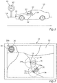
- Fig. 1 shows a schematic representation of a motor vehicle 10 with a display device 12 for displaying a detected for a currently traveled section 14, currently permissible maximum speed 16 according to an embodiment of the invention.
- the currently permissible maximum speed 16 is specified in this example by a corresponding traffic sign 18.
- the motor vehicle 10 may, for example, have a camera 20.
- the image of the traffic sign 18 taken by the camera 20 can be supplied to a processor device 22, which evaluates the recorded image, for example by executing a character recognition software, and extracts therefrom the currently permissible maximum speed 16.
- the processor device 22 can also be designed to control the display device 12 at the same time, or the display device 12 can also have a separate control device.
- the display device 12 displays a first symbol 28a, 28b (cf. Fig. 2 ), which comprises a numerical value 30 representing the currently permissible maximum speed 16.
- the motor vehicle 10 or the display device 12 is now designed to effect a change of the symbol, which is different from a change of the numerical value 30, as a function of a change in at least one detected environmental parameter.
- This change may relate, on the one hand, to the change of a current geographical position, for the detection of which the motor vehicle 10 may, for example, have a GPS receiver 24.
- this change may also relate to the change of the currently permissible maximum speed 16, which can be detected by the camera 20 and the processor device 22.
- the GPS receiver 24 and the processor device 22 and optionally also the display device 12 may be part of a navigation device 28 of the motor vehicle 10.
- the image data captured by the camera 20 are evaluated by a separate processor device (not shown) assigned to the camera 20 and only subsequently be transmitted to the navigation device 28.
- a separate processor device not shown assigned to the camera 20 and only subsequently be transmitted to the navigation device 28.
- Fig. 2 shows a schematic representation of the display device 12 and the display provided by this.
- the first symbol 28a may advantageously be in response to a change in the current geographical position.
- the display device 12 or the navigation device 28 initially provides a map display 32, which is displayed on the display device 12.
- the position 34a of the motor vehicle 10 is shown as a second symbol 36 on the one hand.
- the illustration in Fig. 2 also illustrates the current position 34b at a previous time, wherein the associated second symbol 36 is shown in dashed lines in order to illustrate the temporal representation change in a change in position of the motor vehicle.
- the second symbol 28a representing the current maximum speed 16 is now advantageously located in a predetermined area 38, which in FIG Fig. 2 is schematically illustrated as a dashed circle, but is not shown by the display device 12 to the current position 34 a, 34 b, and preferably shown next to the first symbol 36.
- a predetermined area 38 which in FIG Fig. 2 is schematically illustrated as a dashed circle, but is not shown by the display device 12 to the current position 34 a, 34 b, and preferably shown next to the first symbol 36.
- FIG. 1 shows a flowchart for illustrating the method for displaying the currently permissible maximum speed 16, according to which a change of the symbol 28a takes place as a function of a change in the current geographical position of the motor vehicle 10, according to an embodiment of the invention.
- S10 it is checked in S10 whether the current position of the motor vehicle 10 has changed. This check can be carried out on the basis of a continuous position determination of the motor vehicle 10, for example by the GPS receiver 24. If no change in position is detected in S10, the current representation of the first symbol 28a on the display device 12 with respect to the remaining map display 32 is maintained in S12.
- the first icon 28b may in turn be displayed in the map display 32 of the navigation display, in particular also at a fixed position with respect to the display area of the display device 12, as in this example in the upper left corner. If, for example, it is detected by the camera 20 of the motor vehicle 10 that the currently permissible maximum speed 16 changes, for example if the motor vehicle 10 is passing a new traffic sign 18 with a different speed specification, a change in the visual appearance of the first symbol 28b may temporarily occur be effected.
- the first symbol 28b may be displayed, for example, for a short time, for example three times, flashing and / or also with a signal color and / or enlarged, etc.
- This flashing is to be illustrated in this example by the line marked 40.
- One Such a flashing or otherwise changing the visual appearance of the first symbol 28b does not necessarily have to be represented by the display device 12 of the navigation device, in particular not necessarily in the map display 32, but alternatively or additionally on each be provided any other display device of the motor vehicle, such as in the instrument cluster.
- FIG. 12 is a flow chart illustrating the method of displaying the current maximum speed at which the first icon 28b is changed in optical appearance in response to a detected change in the current maximum speed 16 according to an embodiment of the present invention.
- it is first checked in S20 whether there is even a speed limit or was detected. If this is not the case, no corresponding first symbol is displayed in S22. However, if it is detected in S20 that there is now a speed limit, for example because a corresponding traffic sign has been recognized, then the first symbol is displayed in S24 on the display device 12 and at the same time optically identified, for example by flashing.
- the driver can advantageously be made aware that now there is a speed limit.
- the representation of the first symbol 28b changes to a normal representation in S26, in which the first symbol 28b is thus no longer displayed flashing, for example.
- S28 it is then checked whether a change in the currently permissible maximum speed 16 has been detected. If this is not the case, then the first symbol 28b in S26 is still displayed in the normal representation. However, if it is detected in S28 that a change in the currently permissible maximum speed 16 has taken place, it is again checked in S20 whether there is still a speed limit. If, for example, the currently permissible maximum speed 16 has changed in such a way that there is no longer any speed limit, the representation of the first symbol 28b is again omitted in S22.
- the first symbol in S24 is again displayed in a flashing manner in order to alert the driver to this change in the currently permissible maximum speed 16.
- the numerical value 30 of the first symbol 28b can also be adapted to the changed currently valid maximum speed 16.
- This embodiment of the invention can significantly increase the likelihood that the driver will be aware of changing speed limits.
- first symbol 28a, 28b can be arbitrarily combined with each other.
- the first symbol 28a, 28b corresponding to the currently detected position 34a, 34b can be displayed in the map display 32 and at the same time displayed differently, for example flashing, upon detection of the change in the currently permissible maximum speed 16 for a certain period of time.
Landscapes
- Physics & Mathematics (AREA)
- General Physics & Mathematics (AREA)
- Engineering & Computer Science (AREA)
- Radar, Positioning & Navigation (AREA)
- Remote Sensing (AREA)
- Automation & Control Theory (AREA)
- Navigation (AREA)
- Traffic Control Systems (AREA)
Abstract
Die Erfindung betrifft ein Verfahren zum Anzeigen einer für einen aktuell befahrenen Streckenabschnitt (14) erfassten, aktuell zulässigen Höchstgeschwindigkeit (16) mittels einer Anzeigeeinrichtung (12) für ein Kraftfahrzeug (10), wobei ein erstes Symbol (28a, 28b) auf der Anzeigeeinrichtung (12) angezeigt wird, welches einen Zahlenwert (30) umfasst, der die aktuell zulässige Höchstgeschwindigkeit (16) repräsentiert, wobei eine von einer Änderung des Zahlenwerts (30) verschiedene Änderung des ersten Symbols (28a, 28b) in Abhängigkeit von einer Änderung zumindest eines erfassten Umgebungsparameters erfolgt.The invention relates to a method for displaying a currently permissible maximum speed (16) detected for a currently traveled section (14) by means of a display device (12) for a motor vehicle (10), wherein a first symbol (28a, 28b) on the display device (16). 12), which comprises a numerical value (30) representing the currently permissible maximum speed (16), wherein a change of the first symbol (28a, 28b) different from a change in the numerical value (30) depends on a change of at least one detected environmental parameter takes place.
Description
Die Erfindung betrifft ein Verfahren zum Anzeigen einer für einen aktuell befahrenen Streckenabschnitt erfassten, aktuell zulässigen Höchstgeschwindigkeit mittels einer Anzeigeeinrichtung für ein Kraftfahrzeug, wobei ein erstes Symbol auf der Anzeigeeinrichtung angezeigt wird, welches einen Zahlenwert umfasst, der die aktuell zulässige Höchstgeschwindigkeit repräsentiert. Zur Erfindung gehören auch die Anzeigeeinrichtung die zur Durchführung des Verfahrens, sowie ein Kraftfahrzeug und eine Navigationseinrichtung mit einer solchen Anzeigeeinrichtung.The invention relates to a method for displaying a currently permissible maximum speed detected for a currently traveled section of road by means of a display device for a motor vehicle, wherein a first symbol is displayed on the display device which comprises a numerical value representing the currently permissible maximum speed. The invention also includes the display device for carrying out the method, as well as a motor vehicle and a navigation device with such a display device.
Es ist bekannt, dass aktuell zulässige Höchstgeschwindigkeiten im Kraftfahrzeug beispielsweise im Kombünstrument oder auf einer Anzeigeeinrichtung eines Navigationsgeräts angezeigt werden können. Geschwindigkeitsbegrenzungen, die durch entsprechende Verkehrsschilder oder Verkehrszeichen gekennzeichnet sind, können beispielsweise mit einer Außenkamera des Kraftfahrzeugs erfasst und die entsprechende durch diese Verkehrszeichen vorgegebene aktuell zulässige Höchstgeschwindigkeit durch eine entsprechende Verkehrszeichenerkennungssoftware erkannt werden. Üblicherweise erfolgt dabei die Anzeige der aktuell zulässigen Höchstgeschwindigkeit statisch und ist beispielsweise einem fixen Ort des Kombünstruments oder der Anzeigeeinrichtung des Navigationsgeräts zugewiesen. Zusätzlich zur aktuell zulässigen Höchstgeschwindigkeit können in einem Kraftfahrzeug üblicherweise noch vielzählige weitere Informationen angezeigt werden. Dadurch gestalten sich Anzeigen mitunter sehr unübersichtlich, was leicht zu einem Übersehen wichtiger Informationen führen kann. Gerade Geschwindigkeitsbegrenzungen sind dabei besonders sicherheitsrelevant. Werden Geschwindigkeitsbegrenzungen vom Fahrer übersehen, oder beispielsweise auch Änderungen von Geschwindigkeitsbegrenzungen, so kann dies schwerwiegende Folgen haben.It is known that currently permissible maximum speeds in the motor vehicle can be displayed, for example, in the combination instrument or on a display device of a navigation device. Speed limits, which are identified by corresponding traffic signs or traffic signs, can be detected, for example, with an outside camera of the motor vehicle and the corresponding current permissible maximum speed given by these traffic signs can be recognized by a corresponding traffic sign recognition software. Usually, the display of the currently permissible maximum speed takes place statically and is assigned, for example, to a fixed location of the combination instrument or the display device of the navigation device. In addition to the currently permissible maximum speed, many more information can usually be displayed in a motor vehicle. As a result, advertisements sometimes become very confusing, which can easily lead to an overlook of important information. Straight speed limits are particularly safety-relevant. If speed limits are overlooked by the driver or, for example, changes in speed limits, this can have serious consequences.
Aufgabe der vorliegenden Erfindung ist es daher, ein Verfahren zum Anzeigen einer aktuell zulässigen Höchstgeschwindigkeit, eine Anzeigeeinrichtung, eine Navigationseinrichtung und ein Kraftfahrzeug bereitzustellen, welche eine Verbesserung hinsichtlich der Anzeige der aktuell zulässigen Höchstgeschwindigkeit ermöglichen.It is therefore an object of the present invention to provide a method for indicating a currently permissible maximum speed, a display device, a navigation device and a motor vehicle, which permit an improvement with regard to the display of the currently permissible maximum speed.
Diese Aufgabe wird gelöst durch ein Verfahren, eine Anzeigeeinrichtung, eine Navigationseinrichtung und ein Kraftfahrzeug mit den Merkmalen gemäß der unabhängigen Ansprüche. Vorteilhafte Ausgestaltungen der Erfindung sind in den abhängigen Ansprüchen angegeben.This object is achieved by a method, a display device, a navigation device and a motor vehicle having the features according to the independent claims. Advantageous embodiments of the invention are specified in the dependent claims.
Gemäß dem erfindungsgemäßen Verfahren zum Anzeigen einer für einen aktuell befahrenen Streckenabschnitt erfassten, aktuell zulässigen Höchstgeschwindigkeit mittels einer Anzeigeeinrichtung für ein Kraftfahrzeug wird ein erstes Symbol auf der Anzeigeeinrichtung angezeigt, welches einen Zahlenwert umfasst, der die aktuell zulässige Höchstgeschwindigkeit repräsentiert. Weiterhin erfolgt eine von einer Änderung des Zahlenwerts verschiedene Änderung des ersten Symbols in Abhängigkeit von einer Änderung zumindest eines erfassten Umgebungsparameters.According to the method according to the invention for displaying a currently permissible maximum speed detected for a currently traveled section by means of a display device for a motor vehicle, a first symbol is displayed on the display device which comprises a numerical value representing the currently permissible maximum speed. Furthermore, a change of the first symbol which differs from a change in the numerical value takes place as a function of a change in at least one detected environmental parameter.
Durch eine Änderung des ersten Symbols, worunter also erfindungsgemäß nicht lediglich die Änderung des Zahlenwerts verstanden werden soll, der die aktuell zulässige Höchstgeschwindigkeit angibt, kann die Aufmerksamkeit des Fahrers deutlich besser auf die aktuell zulässige Höchstgeschwindigkeit gelenkt werden. Auch resultieren hieraus deutlich flexiblere und situationsangepasstere Anzeigemöglichkeiten des die aktuell zulässige Höchstgeschwindigkeit repräsentierenden Symbols, was durch die Abhängigkeit von der Änderung des zumindest einen erfassten Umgebungsparameters ermöglicht wird und wie zu vorteilhaften Ausgestaltungen der Erfindung näher beschrieben wird. Hierdurch lässt sich vorteilhafterweise die Verkehrssicherheit deutlich erhöhen.By changing the first symbol, which is therefore to be understood according to the invention not only the change in the numerical value indicating the currently allowed maximum speed, the driver's attention can be much better directed to the currently permissible maximum speed. This also results in significantly more flexible and situation-adapted display options of the currently permissible maximum speed representing symbol, which is made possible by the dependence on the change of at least one detected environmental parameter and as described in more advantageous embodiments of the invention. As a result, the traffic safety can be increased significantly.
Bei einer vorteilhaften Ausgestaltung der Erfindung stellt der zumindest eine erfasste Umgebungsparameter eine aktuelle geografische Position, insbesondere in Form von GPS-Daten, dar. Zum Erfassen der aktuellen geografischen Position kann beispielsweise ein Positionssignal eines GNSS (Global Navigation Satellite System), zum Beispiel des GPS (Global Positioning System) erfasst werden, beispielsweise durch eine geeignete Lokalisierungseinrichtung bzw. einen entsprechenden Empfänger für ein solches Positionssignal, wie zum Beispiel ein GPS-Empfänger. Eine Änderung des die aktuell zulässige Höchstgeschwindigkeit repräsentierenden ersten Symbols korrespondierend zur aktuellen Position bzw. Positionsänderungen ermöglicht es vorteilhafterweise, die aktuell zulässige Höchstgeschwindigkeit mit der aktuellen Position in Verbindung zu bringen.In an advantageous embodiment of the invention, the at least one detected environmental parameter represents a current geographical position, in particular in the form of GPS data. For detecting the current geographical position, for example, a position signal of a GNSS (Global Navigation Satellite System), for example the GPS (Global Positioning System), for example, by a suitable localization device or a corresponding receiver for such a position signal, such as a GPS receiver. A change of the first symbol representing the currently permissible maximum speed corresponding to the current position or position changes advantageously makes it possible to associate the currently permissible maximum speed with the current position.
Die erfasste aktuelle geographische Position bezieht sich dabei auf die Position der Anzeigeeinrichtung und sofern diese in einem erfindungsgemäße Kraftfahrzeug angeordnet ist und/oder Teil einer erfindungsgemäßen Navigationseinrichtung ist, ebenso auf die Position des Kraftfahrzeugs bzw. der Navigationseinrichtung.The detected current geographical position refers to the position of the display device and provided that they are arranged in a motor vehicle according to the invention is and / or is part of a navigation device according to the invention, as well as the position of the motor vehicle or the navigation device.
Dabei ist es gemäß einem weiteren Ausführungsbeispiel der Erfindung besonders vorteilhaft, dass mittels der Anzeigeeinrichtung eine geografische Kartendarstellung angezeigt wird, wobei das erste Symbol in der geografischen Kartendarstellung angezeigt wird und wobei eine Position des angezeigten ersten Symbols in Bezug auf die Kartendarstellung in Abhängigkeit von der Änderung der erfassten aktuellen geografischen Position geändert wird. Analog zu einer Navigationsanzeige, die beispielsweise auf einer Kartendarstellung die aktuelle Position anzeigt, kann nun vorteilhafterweise im Bereich der erfassten aktuellen Position auch die korrespondierende zulässige Höchstgeschwindigkeit angezeigt werden. Das diese Höchstgeschwindigkeit repräsentierende erste Symbol bewegt sich damit, zum Beispiel bei Bewegung des Kraftfahrzeugs, entsprechend mit der Positionsänderung auf der angezeigten Kartendarstellung mit. Blickt ein Fahrer beispielsweise auf die Kartendarstellung, um festzustellen auf welcher Straße er sich gerade befindet, so wird ihm auf diese Weise gleichzeitig auch kenntlich gemacht, ob und welche Geschwindigkeitsbegrenzung für den aktuell befahrenen Streckenabschnitt gerade gilt. Gerade wie im Stand der Technik üblich, bei einer Anzeige der Geschwindigkeitsbegrenzung zum Beispiel im Kombiinstrument, besteht keinerlei Verbindung zwischen der Anzeige der Geschwindigkeitsbegrenzung und der aktuell befahrenen Straße. Dies müsste dann entsprechend durch einen separaten Blick auf die Navigationsanzeige in Erfahrung gebracht werden. Durch diese vorteilhafte Ausgestaltung der Erfindung jedoch können alle nötigen Navigationsinformationen inklusive der wichtigen Angaben über aktuell zulässige Höchstgeschwindigkeiten auf einen Blick erfasst werden.In this case, according to a further exemplary embodiment of the invention, it is particularly advantageous that a geographical map display is displayed by means of the display device, wherein the first icon is displayed in the geographical map display and wherein a position of the displayed first icon in relation to the map display depends on the change changed to the current geographic location. Analogously to a navigation display, which displays the current position, for example, on a map display, the corresponding permissible maximum speed can now advantageously also be displayed in the region of the detected current position. The first symbol representing this maximum speed thus moves, for example during movement of the motor vehicle, according to the change in position on the displayed map display. For example, if a driver is looking at the map display to determine which road he is on at the moment, he will also be informed at the same time whether and which speed limit currently applies to the section of road currently being traveled. Just as usual in the prior art, in an indication of the speed limit, for example in the instrument cluster, there is no connection between the display of the speed limit and the currently traveled road. This would then have to be brought in by a separate view of the navigation display in experience. Due to this advantageous embodiment of the invention, however, all necessary navigation information including the important information about currently permitted maximum speeds can be detected at a glance.
Bei einer weiteren vorteilhaften Ausgestaltung der Erfindung wird das erste Symbol in einem vorbestimmten Bereich um die aktuelle geografische Position in der Kartendarstellung dargestellt, wobei sich eine Position des Bereichs bezüglich der Kartendarstellung bei Änderung der aktuellen geografischen Position in der Kartendarstellung korrespondierend ändert. Wie beschrieben bewegt sich das dargestellte erste Symbol, welches die aktuell zulässige Höchstgeschwindigkeit angibt, korrespondierend zur Bewegung des Kraftfahrzeugs in der Kartendarstellung mit. Dadurch kann der Fahrer sehr einfach seine aktuelle Position mit der aktuell zulässigen Höchstgeschwindigkeit assozüeren. Das erste Symbol kann beispielsweise in der Kartendarstellung an der aktuellen geografischen Position angezeigt werden, und damit beispielsweise nicht nur die aktuell zulässige Höchstgeschwindigkeit, sondern gleichzeitig auch die aktuelle Position des Kraftfahrzeugs repräsentieren, wobei dann auf die separate Anzeige eines den aktuellen Standort oder die aktuelle Position repräsentierenden weiteren Symbol verzichtet werden könnte, was die Übersichtlichkeit der dargestellten Anzeige erhöht.In a further advantageous embodiment of the invention, the first symbol is displayed in a predetermined area around the current geographical position in the map representation, wherein a position of the area with respect to the map representation changes correspondingly when the current geographical position in the map representation changes. As described, the illustrated first symbol, which indicates the currently permissible maximum speed, moves in accordance with the movement of the motor vehicle in the map display. As a result, the driver can easily associate his current position with the currently permissible maximum speed. The first symbol can be displayed, for example, in the map display at the current geographical position, and thus, for example, represent not only the currently permissible maximum speed, but also the current position of the motor vehicle, in which case the separate display of the current location or current symbol representing additional position could be omitted, which increases the clarity of the display shown.
Um jedoch Irritationen des Fahrers durch Abweichungen von herkömmlichen und bekannten Navigationsdarstellungen zu vermeiden, stellt es eine vorteilhafte und bevorzugte Ausgestaltung der Erfindung dar, dass in der Kartendarstellung an der Stelle der aktuellen geografischen Position ein zweites, und insbesondere ausschließlich, die aktuelle geografische Position repräsentierendes Symbol angezeigt wird. Dieses zweite Symbol dient dabei also einzig und allein zur Anzeige der aktuellen Position in der Kartendarstellung. Das erste Symbol, welches die aktuell zulässige Höchstgeschwindigkeit repräsentiert, kann dann entsprechend zum Beispiel neben dem zweiten Symbol in unmittelbarer Nähe zu diesem und im vorbestimmten Bereich angezeigt werden und entsprechend der Änderung der aktuellen Position zusammen mit dem zweiten Symbol gegenüber der Kartendarstellung mitbewegt werden.However, in order to avoid irritations of the driver by deviations from conventional and known navigation representations, it constitutes an advantageous and preferred embodiment of the invention that in the map display at the location of the current geographical position, a second, and in particular exclusively, representing the current geographical position symbol is shown. This second symbol is thus used solely to display the current position in the map display. The first symbol, which represents the currently permissible maximum speed, may then correspondingly be displayed, for example, next to the second symbol in close proximity to this and in the predetermined range and be moved along with the second symbol in relation to the map representation in accordance with the change of the current position.
Bei einer weiteren sehr vorteilhaften Ausgestaltung der Erfindung stellt die Änderung des Umgebungsparameters eine Änderung der aktuell zulässigen Höchstgeschwindigkeit dar. Eine Änderung des ersten die aktuell zulässige Höchstgeschwindigkeit repräsentierenden Symbols, wobei unter dieser Änderung wiederum nicht die Änderung des Zahlenwerts an sich zu verstehen ist, bei einer Änderung der aktuell zulässigen Höchstgeschwindigkeit ist besonders vorteilhaft, da so der Benutzer deutlich besser auf Änderungen der Geschwindigkeitsbegrenzung hingewiesen werden kann.In a further very advantageous embodiment of the invention, the change of the environmental parameter represents a change of the currently permissible maximum speed. A change of the first symbol representing the currently permissible maximum speed, this change again not being understood to mean the change of the numerical value per se, is a change Changing the currently permissible maximum speed is particularly advantageous because it allows the user to be made much better aware of changes in the speed limit.
Bei einer vorteilhaften Ausgestaltung der Erfindung wird hierbei die optische Erscheinung des ersten Symbols bei erfasster Änderung der aktuell zulässigen Höchstgeschwindigkeit, zum Beispiel für eine begrenzte vorbestimmbare Zeitdauer, geändert, insbesondere wobei die optische Erscheinung dadurch geändert wird, indem zumindest ein Teil des ersten Symbols blinkend dargestellt wird. Dadurch kann der Fahrer besonders stark auf Geschwindigkeitsänderungen von Geschwindigkeitsvorgaben aufmerksam gemacht werden. Üblicherweise werden bei Änderungen der Geschwindigkeitsbegrenzung, zum Beispiel bei Anfahrt auf eine Baustelle mit aufeinanderfolgenden Geschwindigkeitsbegrenzungen von 120 km/h, dann 100 km/h, dann 80 km/h, lediglich die Zahlenwerte in einer fließenden Abfolge in der Darstellung geändert. Dies wird sehr häufig von Fahrern übersehen und führt in erhöhtem Maße zu Unfällen. Gerade aber in solchen Situationen, insbesondere wenn Geschwindigkeitsbegrenzungsänderungen unerwartet auftreten, wie beispielsweise im Falle einer Baustelle, kann durch eine Darstellungsänderung in Anpassung an diese erfasste Umgebungssituationsänderung besonders effektiv ein Warnhinweis und eine Kenntlichmachung dieser geänderten Umstände an den Fahrer ausgegeben werden.In an advantageous embodiment of the invention, in this case the optical appearance of the first symbol is changed with detected change of the currently permissible maximum speed, for example for a limited predeterminable period of time, in particular wherein the optical appearance is changed by at least a portion of the first symbol displayed flashing becomes. As a result, the driver can be made particularly aware of speed changes of speed specifications. Usually, when changing the speed limit, for example when approaching a construction site with successive speed limits of 120 km / h, then 100 km / h, then 80 km / h, only the numerical values are changed in a flowing sequence in the representation. This is very often overlooked by drivers and leads to increased accidents. But especially in such situations, especially when speed limit changes occur unexpectedly, such as in the case of a construction site, can be detected by a representation change in adaptation to this Ambient situation change particularly effectively issued a warning and a notice of these changed circumstances to the driver.
Des Weiteren betrifft die Erfindung eine Anzeigeeinrichtung für ein Kraftfahrzeug zum Anzeigen einer für einen aktuell befahrenen Streckenabschnitt erfassten, aktuell zulässigen Höchstgeschwindigkeit, wobei die Anzeigeeinrichtung dazu ausgelegt ist, ein erstes Symbol auf der Anzeigeeinrichtung anzuzeigen, welches einen Zahlenwert umfasst, der die aktuell zulässige Höchstgeschwindigkeit repräsentiert. Des Weiteren ist die Anzeigeeinrichtung dazu ausgelegt, eine von einer Änderung des Zahlenwerts an sich verschiedene Änderung des ersten Symbols in Abhängigkeit von einer Änderung zumindest eines erfassten Umgebungsparameters zu bewirken.The invention further relates to a display device for a motor vehicle for displaying a currently permissible maximum speed detected for a currently traveled stretch of road, the display device being designed to display a first symbol on the display device which comprises a numerical value representing the currently permissible maximum speed , Furthermore, the display device is designed to bring about a change of the first symbol that is different in itself from a change in the numerical value as a function of a change in at least one detected environmental parameter.
Die für das erfindungsgemäße Verfahren und seine Ausgestaltungen beschriebenen Merkmale, Merkmalskombinationen und deren Vorteile gelten in gleicher Weise für die erfindungsgemäße Anzeigeeinrichtung. Darüber hinaus ermöglichen die im Zusammenhang mit dem erfindungsgemäßen Verfahren beschriebenen Verfahrensschritte die Weiterbildung der erfindungsgemäßen Anzeigeeinrichtung durch weitere gegenständliche Merkmale.The features described for the method and its embodiments, feature combinations and their advantages apply in the same way for the display device according to the invention. In addition, the method steps described in connection with the method according to the invention allow the development of the display device according to the invention by further representational features.
Darüber hinaus betrifft die Erfindung auch eine Navigationseinrichtung mit einer erfindungsgemäßen Anzeigeeinrichtung, sowie auch ein Kraftfahrzeug mit einer erfindungsgemäßen Anzeigeeinrichtung, sowie auch ein Kraftfahrzeug mit einer erfindungsgemäßen Navigationseinrichtung.In addition, the invention also relates to a navigation device with a display device according to the invention, as well as a motor vehicle with a display device according to the invention, as well as a motor vehicle with a navigation device according to the invention.
Gemäß vorteilhaften Weiterbildungen kann das Kraftfahrzeug und/oder die Navigationseinrichtung beispielsweise eine Positionsbestimmungseinrichtung, wie beispielsweise einen GPS-Empfänger, aufweisen um die aktuelle geografische Position zu bestimmen. Weiterhin kann das Kraftfahrzeug beispielsweise eine oder mehrere Außenkameras aufweisen, die zur Verkehrszeichenerkennung geeignet sind, sodass die aktuell zulässige Höchstgeschwindigkeit auf einem gegebenen Streckenabschnitt kamerabasiert erfasst werden kann. Hierzu kann das Kraftfahrzeug weiterhin auch einen Speicher mit einer Verkehrszeichenerkennungssoftware, die zur Verkehrszeichenerkennung auf Basis der von der Außenkamera aufgenommenen Bildern und insbesondere zur Erfassung der aktuell zulässigen Höchstgeschwindigkeit aus diesen Bildern geeignet ist. Die Erfassung der aktuellen Höchstgeschwindigkeit lässt sich jedoch nicht nur durch kamerabasierte Verkehrszeichenerkennung realisieren. Alternativ oder zusätzlich können auch Navigationsdaten der Navigationseinrichtung genutzt werden, um aktuell zulässige Höchstgeschwindigkeiten zu bestimmen, insbesondere auch unabhängig von einer kamerabasierten Erfassung. Hierzu können beispielsweise zu entsprechenden Streckenabschnitten in den Navigationsdaten bereits Geschwindigkeitsbegrenzungen, zum Beispiel innerorts, oder auf Landstraßen, abgelegt sein. Durch diese Erfassungsmittel können vorteilhafterweise die genannten Umgebungsparameter und deren Änderungen erfasst werden und beispielsweise an die Anzeigeeinrichtung übermittelt werden, welche in korrespondierender Weise in Abhängigkeit von den übermittelten und empfangenen Umgebungsparametern eine entsprechende Änderung des ersten Symbols bewirkt. Auch kann es vorgesehen sein, dass die von den genannten Erfassungsmitteln erfassten Umgebungsparameter an eine Steuereinrichtung, die beispielsweise Teil der Navigationseinrichtung sein kann, übermittelt werden, welche darauf basierend eine entsprechende Ansteuerung der Anzeigeeinrichtung vornimmt. Entsprechend gehört zur Erfindung auch die Steuervorrichtung für das Kraftfahrzeug und/oder der Navigationseinrichtung und/oder der Anzeigeeinrichtung. Die Steuervorrichtung weist eine Prozessoreinrichtung auf, die dazu eingerichtet ist, eine Ausführungsform des erfindungsgemäßen Verfahrens durchzuführen. Die Prozessoreinrichtung kann hierzu zumindest einen Mikroprozessor und/oder zumindest einen Mikrocontroller aufweisen. Des Weiteren kann die Prozessoreinrichtung Programmcode aufweisen, der dazu eingerichtet ist, bei Ausführen durch die Prozessoreinrichtung die Ausführungsform des erfindungsgemäßen Verfahrens durchzuführen. Der Programmcode kann in einem Datenspeicher der Prozessoreinrichtung gespeichert sein.According to advantageous developments, the motor vehicle and / or the navigation device, for example, a position determination device, such as a GPS receiver, have to determine the current geographical position. Furthermore, the motor vehicle, for example, one or more outdoor cameras have, which are suitable for traffic sign recognition, so that the currently permissible maximum speed on a given section of road can be detected camera-based. For this purpose, the motor vehicle may also be a memory with a traffic sign recognition software, which is suitable for traffic sign recognition based on the images taken by the external camera and in particular for detecting the currently permissible maximum speed from these images. However, the detection of the current maximum speed can not be realized only by camera-based traffic sign recognition. Alternatively or additionally, navigation data of the navigation device can also be used in order to determine currently permissible maximum speeds, in particular also independently of one camera-based capture. For this purpose, speed limits, for example, in urban areas or on country roads, may already be stored for example at corresponding route sections in the navigation data. By means of these detection means, the mentioned environmental parameters and their changes can advantageously be detected and transmitted to the display device, for example, which correspondingly effects a corresponding change of the first symbol as a function of the transmitted and received environmental parameters. It may also be provided that the environmental parameters detected by the aforementioned detection means are transmitted to a control device, which may be part of the navigation device, for example, which based thereon performs a corresponding control of the display device. Accordingly, the invention also includes the control device for the motor vehicle and / or the navigation device and / or the display device. The control device has a processor device which is set up to carry out an embodiment of the method according to the invention. For this purpose, the processor device can have at least one microprocessor and / or at least one microcontroller. Furthermore, the processor device can have program code which is set up to execute the embodiment of the method according to the invention when executed by the processor device. The program code may be stored in a data memory of the processor device.
Weitere Vorteile, Merkmale und Einzelheiten der Erfindung ergeben sich aus der nachfolgenden Beschreibung eines bevorzugten Ausführungsbeispiels sowie anhand der Zeichnung. Die vorstehend in der Beschreibung genannten Merkmale und Merkmalskombinationen sowie die nachfolgend in der Figurenbeschreibung genannten und/oder in den Figuren alleine gezeigten Merkmale und Merkmalskombinationen sind nicht nur in der jeweils angegebenen Kombination, sondern auch in anderen Kombinationen oder in Alleinstellung verwendbar, ohne den Rahmen der Erfindung zu verlassen.Further advantages, features and details of the invention will become apparent from the following description of a preferred embodiment and from the drawing. The features and feature combinations mentioned above in the description as well as the features and feature combinations mentioned below in the description of the figures and / or in the figures alone can be used not only in the respectively specified combination but also in other combinations or in isolation, without the scope of To leave invention.
Dabei zeigen:
- Fig.1
- eine schematische Darstellung eines Kraftfahrzeugs mit einer Anzeigeeinrichtung zum Anzeigen der aktuell zulässigen Höchstgeschwindigkeit gemäß einem Ausführungsbeispiel der Erfindung;
- Fig. 2
- eine schematische Darstellung der durch die Anzeigeeinrichtung angezeigten Darstellung gemäß einem Ausführungsbeispiel der Erfindung;
- Fig. 3
- ein Ablaufdiagramm zur Veranschaulichung eines Verfahrens zum Anzeigen der aktuell zulässigen Höchstgeschwindigkeit gemäß einem Ausführungsbeispiel der Erfindung; und
- Fig. 4
- ein Ablaufdiagramm zur Veranschaulichung eines Verfahrens zum Anzeigen der aktuell zulässigen Höchstgeschwindigkeit gemäß einem weiteren Ausführungsbeispiel der Erfindung.
- Fig.1
- a schematic representation of a motor vehicle with a display device for displaying the currently permissible maximum speed according to an embodiment of the invention;
- Fig. 2
- a schematic representation of the displayed by the display device representation according to an embodiment of the invention;
- Fig. 3
- a flowchart illustrating a method for displaying the current maximum speed according to an embodiment of the invention; and
- Fig. 4
- a flowchart for illustrating a method for displaying the currently permissible maximum speed according to another embodiment of the invention.
Das Kraftfahrzeug 10 bzw. die Anzeigeeinrichtung 12 ist nun dazu ausgelegt, eine von einer Änderung des Zahlenwerts 30 verschiedene Änderung des Symbols in Abhängigkeit von einer Änderung zumindest eines erfassten Umgebungsparameters zu bewirken. Diese Änderung kann dabei zum einen die Änderung einer aktuellen geographischen Position betreffen, zu deren Erfassung das Kraftfahrzeug 10 zum Beispiel einen GPS-Empfänger 24 aufweisen kann. Zum anderen kann diese Änderung auch die Änderung der aktuell zulässigen Höchstgeschwindigkeit 16 betreffen, welche durch die Kamera 20 und die Prozessoreinrichtung 22 detektiert werden kann. Der GPS-Empfänger 24 und die Prozessoreinrichtung 22 und optional auch die Anzeigeeinrichtung 12 können dabei Teil einer Navigationseinrichtung 28 des Kraftfahrzeugs 10 sein. Zudem ist es auch denkbar, dass die von der Kamera 20 erfassten Bilddaten durch eine der Kamera 20 zugeordnete separate Prozessoreinrichtung (nicht dargestellt) ausgewertet werden und erst anschließend an die Navigationseinrichtung 28 übermittelt werden. Die durch die erfassten Änderungen des Umgebungsparameters bewirkten vorteilhaften Änderungen des ersten Symbols 28a, 28b werden nun anhand von
Dies hat den großen Vorteil, dass ein Fahrer, der auf die Navigationsanzeige, die durch die Anzeigeeinrichtung 12 bereitgestellt wird, blickt, um seine aktuelle Position 34a, 34b zu erfahren oder auch den aktuell befahrenen Straßenabschnitt bzw. Streckenabschnitt 14, damit auch gleichzeitig erkennen kann, ob und welche aktuell zulässige Höchstgeschwindigkeit 16 auf diesem Abschnitt gerade vorgeschrieben ist. Hierdurch kann ein direkter optischer Bezug zur aktuell zulässigen Höchstgeschwindigkeit 16 auf die Straße als momentaner Fahrbereich in der Karte stattfinden. Indem also die von der Verkehrszeichenerkennung angezeigte Geschwindigkeit, welche durch den Zahlenwert 30 repräsentiert wird, dem Navigationsgerät bzw. der Anzeigeeinrichtung 12 des Navigationsgeräts dargestellten Cursors, das heißt des zweiten Symbols 36, folgt, ist somit unmittelbar im Kontext zu der Straße, auf der man im Moment fährt auch die aktuell zulässige Höchstgeschwindigkeit 16 zu erkennen. Mit Blick auf die Karte im Navigationsgerät wird sofort die vorgegebene Geschwindigkeit in Bezug auf die Straße auf der man sich im Moment befindet, erkannt.This has the great advantage that a driver who looks at the navigation display provided by the
Diese positionsabhängige Änderung des ersten Symbols 28a wird nun anhand von
Eine Änderung des Symbols 28a, 28b kann jedoch noch auf eine andere Weise stattfinden, nämlich in Abhängigkeit von einer Änderung der aktuell zulässigen Höchstgeschwindigkeit 16, was im Folgenden wiederum anhand von
Durch diese Ausführungsform der Erfindung kann die Wahrscheinlichkeit, dass der Fahrer sich ändernde Geschwindigkeitsbegrenzungen beachtet, deutlich erhöht werden.This embodiment of the invention can significantly increase the likelihood that the driver will be aware of changing speed limits.
Auch können diese beiden Arten der Änderung des ersten Symbols 28a, 28b beliebig miteinander kombiniert werden. Beispielsweise kann das erste Symbol 28a, 28b korrespondierend zur aktuell erfassten Position 34a, 34b in der Kartendarstellung 32 dargestellt werden und gleichzeitig bei erfasster Änderung der aktuell zulässigen Höchstgeschwindigkeit 16 für eine bestimmte Zeitdauer anders, zum Beispiel blinkend, dargestellt werden.Also, these two ways of changing the
Insgesamt werden so ein Verfahren, eine Anzeigeeinrichtung, eine Navigationseinrichtung und ein Kraftfahrzeug bereitgestellt, welche die Erkennbarkeit einer aktuell zulässigen Höchstgeschwindigkeit sowie auch deren Änderung deutlich verbessern.Overall, such a method, a display device, a navigation device and a motor vehicle are provided which significantly improve the recognizability of a currently permissible maximum speed and also the change thereof.
- 1010
- Kraftfahrzeugmotor vehicle
- 1212
- Anzeigeeinrichtungdisplay
- 1414
- Streckenabschnittstretch
- 1616
- aktuell zulässige Höchstgeschwindigkeitcurrently allowed maximum speed
- 1818
- Verkehrszeichenroad sign
- 2020
- Kameracamera
- 2222
- Prozessoreinrichtungprocessor means
- 2424
- GPS-EmpfängerGPS receiver
- 2626
- Navigationseinrichtungnavigation device
- 28a, 28b28a, 28b
- erstes Symbolfirst symbol
- 3030
- Zahlenwertvalue
- 3232
- Kartendarstellungmap display
- 34a, 34b34a, 34b
- aktuelle Positionactual position
- 3636
- zweites Symbolsecond symbol
- 3838
- vorbestimmter Bereichpredetermined area
- 4040
- Linieline
- S10S10
- Schrittstep
- S12S12
- Schrittstep
- S14S14
- Schrittstep
- S16S16
- Schrittstep
- S20S20
- Schrittstep
- S22S22
- Schrittstep
- S24S24
- Schrittstep
- S26S26
- Schrittstep
- S28S28
- Schrittstep
Claims (10)
dadurch gekennzeichnet, dass
eine von einer Änderung des Zahlenwerts (30) verschiedene Änderung des ersten Symbols (28a, 28b) in Abhängigkeit von einer Änderung zumindest eines erfassten Umgebungsparameters erfolgt.A method for displaying a currently permissible maximum speed (16) detected for a currently traveled section (14) by means of a display device (12) for a motor vehicle (10), wherein a first symbol (28a, 28b) is displayed on the display device (12) which comprises a numerical value (30) representing the currently permissible maximum speed (16),
characterized in that
a change of the first symbol (28a, 28b) that differs from a change of the numerical value (30) takes place as a function of a change of at least one detected environmental parameter.
dadurch gekennzeichnet, dass
der zumindest eine erfasste Umgebungsparameter eine aktuelle geographische Position (34a, 34b), insbesondere in Form von GPS Daten, darstellt.Method according to claim 1,
characterized in that
the at least one detected environmental parameter represents a current geographical position (34a, 34b), in particular in the form of GPS data.
dadurch gekennzeichnet, dass
mittels der Anzeigeeinrichtung (12) eine geographische Kartendarstellung (32) angezeigt wird, wobei das erste Symbol (28a, 28b) in der geographischen Kartendarstellung (32) angezeigt wird und wobei eine Position des angezeigten ersten Symbols (28a, 28b) in Bezug auf die Kartendarstellung in Abhängigkeit von der Änderung der erfassten aktuellen geographischen Position (34a, 34b) geändert wird.Method according to claim 2,
characterized in that
a geographic map representation (32) is displayed by the display means (12), wherein the first symbol (28a, 28b) is displayed in the geographic map representation (32) and wherein a position of the displayed first symbol (28a, 28b) with respect to Map representation in response to the change of the detected current geographical position (34a, 34b) is changed.
dadurch gekennzeichnet, dass
das erste Symbol (28a, 28b) in einem vorbestimmten Bereich (38) um die aktuelle geographische Position (34a, 34b) in der Kartendarstellung (32) dargestellt wird, wobei sich eine Position des Bereichs (38) bezüglich der Kartendarstellung (32) bei Änderung der aktuellen geographischen Position (34a, 34b) in der Kartendarstellung (32) korrespondierend ändert.Method according to claim 3,
characterized in that
the first symbol (28a, 28b) is displayed in a predetermined area (38) about the current geographical position (34a, 34b) in the map display (32), wherein a position of the area (38) relative to the map representation (32) is included Changing the current geographical position (34a, 34b) in the map display (32) correspondingly changes.
dadurch gekennzeichnet, dass
in der Kartendarstellung (32) an der Stelle der aktuellen geographischen Position (34a, 34b) ein zweites die aktuelle geographische Position (34a, 34b) repräsentierendes Symbol (36) angezeigt wird.Method according to one of claims 3 or 4,
characterized in that
in the map display (32) at the location of the current geographical position (34a, 34b), a second icon representing the current geographical position (34a, 34b) is displayed.
dadurch gekennzeichnet, dass
die Änderung des Umgebungsparameters eine Änderung der aktuell zulässigen Höchstgeschwindigkeit (16) darstellt.Method according to one of the preceding claims,
characterized in that
the change of the environmental parameter represents a change of the currently permissible maximum speed (16).
dadurch gekennzeichnet, dass
die optische Erscheinung des ersten Symbols (28a, 28b) bei erfasster Änderung der aktuell zulässigen Höchstgeschwindigkeit (16) für eine begrenzte vorbestimmbare Zeitdauer geändert wird, insbesondere wobei die optische Erscheinung dadurch geändert wird, indem zumindest ein Teil des ersten Symbols (28a, 28b) blinkend dargestellt wird.Method according to claim 6,
characterized in that
the visual appearance of the first symbol (28a, 28b) is changed for a limited predeterminable period of time upon detection of the change in the currently permissible maximum speed (16), in particular wherein the visual appearance is changed by changing at least part of the first symbol (28a, 28b) is flashing.
dadurch gekennzeichnet, dass
die Anzeigeeinrichtung (12) dazu ausgelegt ist, eine von einer Änderung des Zahlenwerts (30) verschiedene Änderung des ersten Symbols (28a, 28b) in Abhängigkeit von einer Änderung zumindest eines erfassten Umgebungsparameters zu bewirken.Display device (12) for a motor vehicle for displaying a currently permissible maximum speed (16) detected for a currently traveled section (14), wherein the display device (12) is adapted to display a first symbol (28a, 28b) on the display device (12 ), which comprises a numerical value (30) representing the currently permissible maximum speed (16),
characterized in that
the display device (12) is designed to effect a change of the first symbol (28a, 28b), which is different from a change of the numerical value (30), as a function of a change of at least one detected environmental parameter.
Applications Claiming Priority (1)
| Application Number | Priority Date | Filing Date | Title |
|---|---|---|---|
| CZ2016610 | 2016-09-30 |
Publications (2)
| Publication Number | Publication Date |
|---|---|
| EP3301399A1 true EP3301399A1 (en) | 2018-04-04 |
| EP3301399B1 EP3301399B1 (en) | 2021-11-10 |
Family
ID=59895025
Family Applications (1)
| Application Number | Title | Priority Date | Filing Date |
|---|---|---|---|
| EP17020422.6A Active EP3301399B1 (en) | 2016-09-30 | 2017-09-13 | Method for displaying the current authorised maximum speed and corresponding display device, navigation device and motor vehicle |
Country Status (1)
| Country | Link |
|---|---|
| EP (1) | EP3301399B1 (en) |
Citations (4)
| Publication number | Priority date | Publication date | Assignee | Title |
|---|---|---|---|---|
| DE102009019023A1 (en) * | 2009-02-27 | 2010-01-21 | Daimler Ag | Display unit controlling method for vehicle, involves detecting detection positions of speed information, and outputting speed information on display unit depending upon detection position with respect to extension of driving route |
| US20110288770A1 (en) * | 2010-05-19 | 2011-11-24 | Garmin Ltd. | Speed limit change notification |
| WO2013139840A1 (en) * | 2012-03-23 | 2013-09-26 | Jaguar Land Rover Limited | Vehicle speedometer and related method |
| FR2991045A1 (en) * | 2012-05-23 | 2013-11-29 | Peugeot Citroen Automobiles Sa | Processing device for display system equipped in e.g. car, has processing unit to generate images including horizontal line and pictogram whose position varies based on difference between current speed and target speed of vehicle |
Family Cites Families (1)
| Publication number | Priority date | Publication date | Assignee | Title |
|---|---|---|---|---|
| JPH08128838A (en) * | 1994-11-01 | 1996-05-21 | Fujitsu Ten Ltd | Navigation device |
-
2017
- 2017-09-13 EP EP17020422.6A patent/EP3301399B1/en active Active
Patent Citations (4)
| Publication number | Priority date | Publication date | Assignee | Title |
|---|---|---|---|---|
| DE102009019023A1 (en) * | 2009-02-27 | 2010-01-21 | Daimler Ag | Display unit controlling method for vehicle, involves detecting detection positions of speed information, and outputting speed information on display unit depending upon detection position with respect to extension of driving route |
| US20110288770A1 (en) * | 2010-05-19 | 2011-11-24 | Garmin Ltd. | Speed limit change notification |
| WO2013139840A1 (en) * | 2012-03-23 | 2013-09-26 | Jaguar Land Rover Limited | Vehicle speedometer and related method |
| FR2991045A1 (en) * | 2012-05-23 | 2013-11-29 | Peugeot Citroen Automobiles Sa | Processing device for display system equipped in e.g. car, has processing unit to generate images including horizontal line and pictogram whose position varies based on difference between current speed and target speed of vehicle |
Also Published As
| Publication number | Publication date |
|---|---|
| EP3301399B1 (en) | 2021-11-10 |
Similar Documents
| Publication | Publication Date | Title |
|---|---|---|
| EP2641057B1 (en) | Procedure for displaying navigation instructions | |
| EP2289058B1 (en) | Method for combined output of an image and a piece of local information and corresponding motor vehicle | |
| DE102014221132B4 (en) | Method and device for indicating availability of a first driving mode of a vehicle | |
| WO2019170387A1 (en) | Overlaying additional information on a display unit | |
| DE102008010968A1 (en) | Display of a relevant traffic sign or a relevant traffic facility | |
| DE102006010478A1 (en) | Method and arrangement for displaying navigation instructions | |
| DE102014003550A1 (en) | Method and device for assisting a driver in driving a vehicle | |
| DE102010034853A1 (en) | Motor vehicle with digital projectors | |
| WO2007036397A1 (en) | Night vision device for a motor vehicle | |
| DE102007016868A1 (en) | Method for displaying a lane course and control device | |
| EP3649434B1 (en) | Method and device for displaying lane information in a vehicle | |
| DE102016220647A1 (en) | A method of presenting at least one supplementary difference lane equipment | |
| DE102010003851A1 (en) | Destination marking method for motor vehicle driver, involves determining position of destination relative to vehicle, and embedding virtual object in real vehicle environment that is visible to vehicle occupant on head-up display | |
| WO2013102508A1 (en) | Method and device for informing a driver | |
| DE102017107484A1 (en) | A method of providing a display assisting a driver of a motor vehicle, driver assistance system and motor vehicle | |
| EP3224116A1 (en) | Method for characterizing camera images of a parking assistant | |
| EP2756490B1 (en) | Method and device for presenting traffic sign information | |
| DE102020004215A1 (en) | Method for representing a traffic situation in a vehicle | |
| EP3318846B1 (en) | Method for displaying a navigation display, navigation system and motor vehicle | |
| DE102009019023A1 (en) | Display unit controlling method for vehicle, involves detecting detection positions of speed information, and outputting speed information on display unit depending upon detection position with respect to extension of driving route | |
| EP3301399B1 (en) | Method for displaying the current authorised maximum speed and corresponding display device, navigation device and motor vehicle | |
| DE102021104290B3 (en) | Method for at least partially automated parking of a motor vehicle, driver assistance system and motor vehicle | |
| EP3343177A1 (en) | Driver assistance system, computer program product, signal sequence, means of locomotion and method for providing information to a user of a means of locomotion | |
| DE102011119752A1 (en) | Method for route guidance of vehicle e.g. motor car, involves determining and outputting driving instructions for bending process required at road forkings/road junctions of route depending on assigned characteristics | |
| DE102022130172B4 (en) | Method and driver assistance system for supporting a driver when driving in a proximity area of a trajectory |
Legal Events
| Date | Code | Title | Description |
|---|---|---|---|
| PUAI | Public reference made under article 153(3) epc to a published international application that has entered the european phase |
Free format text: ORIGINAL CODE: 0009012 |
|
| STAA | Information on the status of an ep patent application or granted ep patent |
Free format text: STATUS: THE APPLICATION HAS BEEN PUBLISHED |
|
| AK | Designated contracting states |
Kind code of ref document: A1 Designated state(s): AL AT BE BG CH CY CZ DE DK EE ES FI FR GB GR HR HU IE IS IT LI LT LU LV MC MK MT NL NO PL PT RO RS SE SI SK SM TR |
|
| AX | Request for extension of the european patent |
Extension state: BA ME |
|
| STAA | Information on the status of an ep patent application or granted ep patent |
Free format text: STATUS: REQUEST FOR EXAMINATION WAS MADE |
|
| 17P | Request for examination filed |
Effective date: 20181004 |
|
| RBV | Designated contracting states (corrected) |
Designated state(s): AL AT BE BG CH CY CZ DE DK EE ES FI FR GB GR HR HU IE IS IT LI LT LU LV MC MK MT NL NO PL PT RO RS SE SI SK SM TR |
|
| STAA | Information on the status of an ep patent application or granted ep patent |
Free format text: STATUS: REQUEST FOR EXAMINATION WAS MADE |
|
| GRAP | Despatch of communication of intention to grant a patent |
Free format text: ORIGINAL CODE: EPIDOSNIGR1 |
|
| STAA | Information on the status of an ep patent application or granted ep patent |
Free format text: STATUS: GRANT OF PATENT IS INTENDED |
|
| INTG | Intention to grant announced |
Effective date: 20210611 |
|
| GRAS | Grant fee paid |
Free format text: ORIGINAL CODE: EPIDOSNIGR3 |
|
| GRAA | (expected) grant |
Free format text: ORIGINAL CODE: 0009210 |
|
| STAA | Information on the status of an ep patent application or granted ep patent |
Free format text: STATUS: THE PATENT HAS BEEN GRANTED |
|
| AK | Designated contracting states |
Kind code of ref document: B1 Designated state(s): AL AT BE BG CH CY CZ DE DK EE ES FI FR GB GR HR HU IE IS IT LI LT LU LV MC MK MT NL NO PL PT RO RS SE SI SK SM TR |
|
| REG | Reference to a national code |
Ref country code: GB Ref legal event code: FG4D Free format text: NOT ENGLISH |
|
| REG | Reference to a national code |
Ref country code: AT Ref legal event code: REF Ref document number: 1446477 Country of ref document: AT Kind code of ref document: T Effective date: 20211115 Ref country code: CH Ref legal event code: EP |
|
| REG | Reference to a national code |
Ref country code: DE Ref legal event code: R096 Ref document number: 502017011946 Country of ref document: DE |
|
| REG | Reference to a national code |
Ref country code: IE Ref legal event code: FG4D Free format text: LANGUAGE OF EP DOCUMENT: GERMAN |
|
| REG | Reference to a national code |
Ref country code: LT Ref legal event code: MG9D |
|
| REG | Reference to a national code |
Ref country code: NL Ref legal event code: MP Effective date: 20211110 |
|
| PG25 | Lapsed in a contracting state [announced via postgrant information from national office to epo] |
Ref country code: RS Free format text: LAPSE BECAUSE OF FAILURE TO SUBMIT A TRANSLATION OF THE DESCRIPTION OR TO PAY THE FEE WITHIN THE PRESCRIBED TIME-LIMIT Effective date: 20211110 Ref country code: LT Free format text: LAPSE BECAUSE OF FAILURE TO SUBMIT A TRANSLATION OF THE DESCRIPTION OR TO PAY THE FEE WITHIN THE PRESCRIBED TIME-LIMIT Effective date: 20211110 Ref country code: FI Free format text: LAPSE BECAUSE OF FAILURE TO SUBMIT A TRANSLATION OF THE DESCRIPTION OR TO PAY THE FEE WITHIN THE PRESCRIBED TIME-LIMIT Effective date: 20211110 Ref country code: BG Free format text: LAPSE BECAUSE OF FAILURE TO SUBMIT A TRANSLATION OF THE DESCRIPTION OR TO PAY THE FEE WITHIN THE PRESCRIBED TIME-LIMIT Effective date: 20220210 |
|
| PG25 | Lapsed in a contracting state [announced via postgrant information from national office to epo] |
Ref country code: IS Free format text: LAPSE BECAUSE OF FAILURE TO SUBMIT A TRANSLATION OF THE DESCRIPTION OR TO PAY THE FEE WITHIN THE PRESCRIBED TIME-LIMIT Effective date: 20220310 Ref country code: SE Free format text: LAPSE BECAUSE OF FAILURE TO SUBMIT A TRANSLATION OF THE DESCRIPTION OR TO PAY THE FEE WITHIN THE PRESCRIBED TIME-LIMIT Effective date: 20211110 Ref country code: PT Free format text: LAPSE BECAUSE OF FAILURE TO SUBMIT A TRANSLATION OF THE DESCRIPTION OR TO PAY THE FEE WITHIN THE PRESCRIBED TIME-LIMIT Effective date: 20220310 Ref country code: PL Free format text: LAPSE BECAUSE OF FAILURE TO SUBMIT A TRANSLATION OF THE DESCRIPTION OR TO PAY THE FEE WITHIN THE PRESCRIBED TIME-LIMIT Effective date: 20211110 Ref country code: NO Free format text: LAPSE BECAUSE OF FAILURE TO SUBMIT A TRANSLATION OF THE DESCRIPTION OR TO PAY THE FEE WITHIN THE PRESCRIBED TIME-LIMIT Effective date: 20220210 Ref country code: NL Free format text: LAPSE BECAUSE OF FAILURE TO SUBMIT A TRANSLATION OF THE DESCRIPTION OR TO PAY THE FEE WITHIN THE PRESCRIBED TIME-LIMIT Effective date: 20211110 Ref country code: LV Free format text: LAPSE BECAUSE OF FAILURE TO SUBMIT A TRANSLATION OF THE DESCRIPTION OR TO PAY THE FEE WITHIN THE PRESCRIBED TIME-LIMIT Effective date: 20211110 Ref country code: HR Free format text: LAPSE BECAUSE OF FAILURE TO SUBMIT A TRANSLATION OF THE DESCRIPTION OR TO PAY THE FEE WITHIN THE PRESCRIBED TIME-LIMIT Effective date: 20211110 Ref country code: GR Free format text: LAPSE BECAUSE OF FAILURE TO SUBMIT A TRANSLATION OF THE DESCRIPTION OR TO PAY THE FEE WITHIN THE PRESCRIBED TIME-LIMIT Effective date: 20220211 Ref country code: ES Free format text: LAPSE BECAUSE OF FAILURE TO SUBMIT A TRANSLATION OF THE DESCRIPTION OR TO PAY THE FEE WITHIN THE PRESCRIBED TIME-LIMIT Effective date: 20211110 |
|
| PG25 | Lapsed in a contracting state [announced via postgrant information from national office to epo] |
Ref country code: SM Free format text: LAPSE BECAUSE OF FAILURE TO SUBMIT A TRANSLATION OF THE DESCRIPTION OR TO PAY THE FEE WITHIN THE PRESCRIBED TIME-LIMIT Effective date: 20211110 Ref country code: SK Free format text: LAPSE BECAUSE OF FAILURE TO SUBMIT A TRANSLATION OF THE DESCRIPTION OR TO PAY THE FEE WITHIN THE PRESCRIBED TIME-LIMIT Effective date: 20211110 Ref country code: RO Free format text: LAPSE BECAUSE OF FAILURE TO SUBMIT A TRANSLATION OF THE DESCRIPTION OR TO PAY THE FEE WITHIN THE PRESCRIBED TIME-LIMIT Effective date: 20211110 Ref country code: EE Free format text: LAPSE BECAUSE OF FAILURE TO SUBMIT A TRANSLATION OF THE DESCRIPTION OR TO PAY THE FEE WITHIN THE PRESCRIBED TIME-LIMIT Effective date: 20211110 Ref country code: DK Free format text: LAPSE BECAUSE OF FAILURE TO SUBMIT A TRANSLATION OF THE DESCRIPTION OR TO PAY THE FEE WITHIN THE PRESCRIBED TIME-LIMIT Effective date: 20211110 |
|
| REG | Reference to a national code |
Ref country code: DE Ref legal event code: R097 Ref document number: 502017011946 Country of ref document: DE |
|
| PLBE | No opposition filed within time limit |
Free format text: ORIGINAL CODE: 0009261 |
|
| STAA | Information on the status of an ep patent application or granted ep patent |
Free format text: STATUS: NO OPPOSITION FILED WITHIN TIME LIMIT |
|
| 26N | No opposition filed |
Effective date: 20220811 |
|
| PG25 | Lapsed in a contracting state [announced via postgrant information from national office to epo] |
Ref country code: AL Free format text: LAPSE BECAUSE OF FAILURE TO SUBMIT A TRANSLATION OF THE DESCRIPTION OR TO PAY THE FEE WITHIN THE PRESCRIBED TIME-LIMIT Effective date: 20211110 |
|
| PG25 | Lapsed in a contracting state [announced via postgrant information from national office to epo] |
Ref country code: SI Free format text: LAPSE BECAUSE OF FAILURE TO SUBMIT A TRANSLATION OF THE DESCRIPTION OR TO PAY THE FEE WITHIN THE PRESCRIBED TIME-LIMIT Effective date: 20211110 |
|
| PG25 | Lapsed in a contracting state [announced via postgrant information from national office to epo] |
Ref country code: MC Free format text: LAPSE BECAUSE OF FAILURE TO SUBMIT A TRANSLATION OF THE DESCRIPTION OR TO PAY THE FEE WITHIN THE PRESCRIBED TIME-LIMIT Effective date: 20211110 |
|
| PGFP | Annual fee paid to national office [announced via postgrant information from national office to epo] |
Ref country code: CZ Payment date: 20230306 Year of fee payment: 7 |
|
| REG | Reference to a national code |
Ref country code: CH Ref legal event code: PL |
|
| GBPC | Gb: european patent ceased through non-payment of renewal fee |
Effective date: 20220913 |
|
| REG | Reference to a national code |
Ref country code: BE Ref legal event code: MM Effective date: 20220930 |
|
| PG25 | Lapsed in a contracting state [announced via postgrant information from national office to epo] |
Ref country code: IT Free format text: LAPSE BECAUSE OF FAILURE TO SUBMIT A TRANSLATION OF THE DESCRIPTION OR TO PAY THE FEE WITHIN THE PRESCRIBED TIME-LIMIT Effective date: 20211110 |
|
| PG25 | Lapsed in a contracting state [announced via postgrant information from national office to epo] |
Ref country code: LU Free format text: LAPSE BECAUSE OF NON-PAYMENT OF DUE FEES Effective date: 20220913 |
|
| P01 | Opt-out of the competence of the unified patent court (upc) registered |
Effective date: 20230608 |
|
| PG25 | Lapsed in a contracting state [announced via postgrant information from national office to epo] |
Ref country code: LI Free format text: LAPSE BECAUSE OF NON-PAYMENT OF DUE FEES Effective date: 20220930 Ref country code: IE Free format text: LAPSE BECAUSE OF NON-PAYMENT OF DUE FEES Effective date: 20220913 Ref country code: CH Free format text: LAPSE BECAUSE OF NON-PAYMENT OF DUE FEES Effective date: 20220930 |
|
| PGFP | Annual fee paid to national office [announced via postgrant information from national office to epo] |
Ref country code: FR Payment date: 20230530 Year of fee payment: 7 |
|
| PG25 | Lapsed in a contracting state [announced via postgrant information from national office to epo] |
Ref country code: BE Free format text: LAPSE BECAUSE OF NON-PAYMENT OF DUE FEES Effective date: 20220930 |
|
| PG25 | Lapsed in a contracting state [announced via postgrant information from national office to epo] |
Ref country code: GB Free format text: LAPSE BECAUSE OF NON-PAYMENT OF DUE FEES Effective date: 20220913 |
|
| REG | Reference to a national code |
Ref country code: AT Ref legal event code: MM01 Ref document number: 1446477 Country of ref document: AT Kind code of ref document: T Effective date: 20220913 |
|
| PGFP | Annual fee paid to national office [announced via postgrant information from national office to epo] |
Ref country code: DE Payment date: 20230530 Year of fee payment: 7 |
|
| PG25 | Lapsed in a contracting state [announced via postgrant information from national office to epo] |
Ref country code: AT Free format text: LAPSE BECAUSE OF NON-PAYMENT OF DUE FEES Effective date: 20220913 |
|
| PG25 | Lapsed in a contracting state [announced via postgrant information from national office to epo] |
Ref country code: HU Free format text: LAPSE BECAUSE OF FAILURE TO SUBMIT A TRANSLATION OF THE DESCRIPTION OR TO PAY THE FEE WITHIN THE PRESCRIBED TIME-LIMIT; INVALID AB INITIO Effective date: 20170913 |
|
| PG25 | Lapsed in a contracting state [announced via postgrant information from national office to epo] |
Ref country code: CY Free format text: LAPSE BECAUSE OF FAILURE TO SUBMIT A TRANSLATION OF THE DESCRIPTION OR TO PAY THE FEE WITHIN THE PRESCRIBED TIME-LIMIT Effective date: 20211110 |