EP3228988B1 - Gps-basierte gebietserkennung in fahrzeugen - Google Patents
Gps-basierte gebietserkennung in fahrzeugen Download PDFInfo
- Publication number
- EP3228988B1 EP3228988B1 EP17159608.3A EP17159608A EP3228988B1 EP 3228988 B1 EP3228988 B1 EP 3228988B1 EP 17159608 A EP17159608 A EP 17159608A EP 3228988 B1 EP3228988 B1 EP 3228988B1
- Authority
- EP
- European Patent Office
- Prior art keywords
- vehicle
- polygons
- coordinate
- area
- areas
- Prior art date
- Legal status (The legal status is an assumption and is not a legal conclusion. Google has not performed a legal analysis and makes no representation as to the accuracy of the status listed.)
- Active
Links
Images
Classifications
-
- G—PHYSICS
- G01—MEASURING; TESTING
- G01C—MEASURING DISTANCES, LEVELS OR BEARINGS; SURVEYING; NAVIGATION; GYROSCOPIC INSTRUMENTS; PHOTOGRAMMETRY OR VIDEOGRAMMETRY
- G01C21/00—Navigation; Navigational instruments not provided for in groups G01C1/00 - G01C19/00
- G01C21/38—Electronic maps specially adapted for navigation; Updating thereof
- G01C21/3863—Structures of map data
- G01C21/3867—Geometry of map features, e.g. shape points, polygons or for simplified maps
-
- G—PHYSICS
- G01—MEASURING; TESTING
- G01C—MEASURING DISTANCES, LEVELS OR BEARINGS; SURVEYING; NAVIGATION; GYROSCOPIC INSTRUMENTS; PHOTOGRAMMETRY OR VIDEOGRAMMETRY
- G01C21/00—Navigation; Navigational instruments not provided for in groups G01C1/00 - G01C19/00
- G01C21/20—Instruments for performing navigational calculations
-
- G—PHYSICS
- G01—MEASURING; TESTING
- G01C—MEASURING DISTANCES, LEVELS OR BEARINGS; SURVEYING; NAVIGATION; GYROSCOPIC INSTRUMENTS; PHOTOGRAMMETRY OR VIDEOGRAMMETRY
- G01C21/00—Navigation; Navigational instruments not provided for in groups G01C1/00 - G01C19/00
- G01C21/26—Navigation; Navigational instruments not provided for in groups G01C1/00 - G01C19/00 specially adapted for navigation in a road network
- G01C21/34—Route searching; Route guidance
- G01C21/3453—Special cost functions, i.e. other than distance or default speed limit of road segments
- G01C21/3469—Fuel consumption; Energy use; Emission aspects
-
- G—PHYSICS
- G01—MEASURING; TESTING
- G01S—RADIO DIRECTION-FINDING; RADIO NAVIGATION; DETERMINING DISTANCE OR VELOCITY BY USE OF RADIO WAVES; LOCATING OR PRESENCE-DETECTING BY USE OF THE REFLECTION OR RERADIATION OF RADIO WAVES; ANALOGOUS ARRANGEMENTS USING OTHER WAVES
- G01S19/00—Satellite radio beacon positioning systems; Determining position, velocity or attitude using signals transmitted by such systems
- G01S19/38—Determining a navigation solution using signals transmitted by a satellite radio beacon positioning system
- G01S19/39—Determining a navigation solution using signals transmitted by a satellite radio beacon positioning system the satellite radio beacon positioning system transmitting time-stamped messages, e.g. GPS [Global Positioning System], GLONASS [Global Orbiting Navigation Satellite System] or GALILEO
- G01S19/42—Determining position
- G01S19/45—Determining position by combining measurements of signals from the satellite radio beacon positioning system with a supplementary measurement
-
- H—ELECTRICITY
- H04—ELECTRIC COMMUNICATION TECHNIQUE
- H04W—WIRELESS COMMUNICATION NETWORKS
- H04W4/00—Services specially adapted for wireless communication networks; Facilities therefor
- H04W4/02—Services making use of location information
- H04W4/021—Services related to particular areas, e.g. point of interest [POI] services, venue services or geofences
-
- G—PHYSICS
- G01—MEASURING; TESTING
- G01C—MEASURING DISTANCES, LEVELS OR BEARINGS; SURVEYING; NAVIGATION; GYROSCOPIC INSTRUMENTS; PHOTOGRAMMETRY OR VIDEOGRAMMETRY
- G01C21/00—Navigation; Navigational instruments not provided for in groups G01C1/00 - G01C19/00
- G01C21/26—Navigation; Navigational instruments not provided for in groups G01C1/00 - G01C19/00 specially adapted for navigation in a road network
- G01C21/28—Navigation; Navigational instruments not provided for in groups G01C1/00 - G01C19/00 specially adapted for navigation in a road network with correlation of data from several navigational instruments
- G01C21/30—Map- or contour-matching
Definitions
- the invention relates to a method, using numerical geoposition data, which indicate the current geoposition of a vehicle, and digital maps, which contain area polygons, each representing a geographical area on the earth, in the vehicle in which of the different areas the vehicle is located just located, and a vehicle set up to carry out the method according to the preambles of the independent claims.
- Such a method and vehicle are from the US 2014/0 372 024 A1 and from the US 2014/0 278 038 A1 known.
- driver assistance systems in modern motor vehicles, some work depending on the environment in which the vehicle is currently located, and the functional accuracy and availability of such driver assistance systems can be improved by information from a navigation system, for example by information in which country or other geographical area Area the motor vehicle is currently located in order to enable country or area-specific system behavior.
- a motor vehicle contains a navigation system that continuously compares the geoposition of the vehicle with a digital map
- area information for driver assistance systems is also readily available, namely as an area code, e.g. B. a country code to the road currently being used.
- Navigation systems that use GPS data calculate the current vehicle position very precisely in geo-coordinates, i.e. as an absolute position, and much more precisely than is actually necessary to support driver assistance systems.
- Navigation systems are often not part of the standard equipment of motor vehicles, and even if this is the case, the driver should be able to deactivate navigation.
- the invention is based on the object of determining in a vehicle with as little effort as possible, but with sufficient accuracy, in which geographic area the vehicle is currently located in order to ensure the performance and availability of driver assistance systems if no navigation system is available in the vehicle or is not currently in operation.
- a boundary pre-check is first performed, selecting candidate area polygons that are near the current vehicle position.
- the selected candidate area polygons are then successively subjected to a PIP test (point-in polygon test) in order to determine whether the current vehicle position is in one of the corresponding areas.
- PIP test point-in polygon test
- at least one driver assistance system of the vehicle is supplied with an output variable which indicates whether and, if appropriate, in which area the vehicle is currently located.
- the invention makes use of the fact that in most motor vehicles at least one receiver for global navigation satellite systems (GNSS) is installed as standard, a device that can determine its own geographic position from the satellite signals.
- GNSS global navigation satellite systems
- Such GPS or related position determining devices are even mandatory with the introduction of the automatic emergency call system for motor vehicles (eCall) and cannot be easily deactivated.
- GNSS devices only provide the absolute geoposition as pure numerical values, it is possible with the invention to use this to obtain area information that is precise enough for driver assistance systems with a minimum of memory and computing effort.
- the method according to the invention requires only a minimal set of geographic map data with a correspondingly low memory requirement and can be carried out as software which can run on a so-called "embedded platform”.
- the computing times can be predetermined and are shorter than with an exact position determination.
- the method according to the invention is much more precise than mere position estimates, but it is many times faster and more resource-saving than conventional navigation systems.
- the latter is also due to the fact that only the relative positions of the vehicle and the area polygons need to be determined for the invention.
- the method according to the invention is somewhat related to so-called geofencing algorithms, which trigger an action when an imaginary boundary on earth is exceeded.
- the algorithms used for this have no predetermined computing times and do not require as little storage space and are not as easy to implement as the present invention.
- the US 2001 024 203 A1 , US 2012 123 677 A1 and US 2007 083 325 A1 disclose map display or movement devices, but use other polygon processing algorithms than the present invention. In addition, map display devices are not required for the invention.
- the pre-limitation check is carried out by comparing the values of a first coordinate of the current vehicle position with the maximum or minimum coordinate values of the area polygons contained in the digital maps with respect to the first coordinate, and by comparing larger / smaller values. Compare the values of a second coordinate of the current vehicle position orthogonal to the first coordinate with the maximum or minimum coordinate values of the area polygons with respect to the second coordinate.
- the PIP tests are performed without intersection calculations using larger / smaller comparisons of Coordinate values carried out after a suitable coordinate shift, which significantly reduces the computational effort.
- the candidate area polygons selected by means of the delimitation preliminary check are divided into smaller sub-polygons by superimposing parallel strips. Furthermore, a strip is determined by means of a binary search, into which the current vehicle position falls, and the partial polygons falling in the determined strips are then subjected to the PIP tests. This reduces the computing effort even more.
- the geographical areas are preferably administrative or similar areas, which only change in exceptional cases. Therefore, the digital maps do not need to be updated frequently.
- the method according to the invention is particularly suitable for vehicles, in particular motor vehicles, in which a receiver for a global navigation satellite system which delivers the geoposition data but no navigation system is installed and which have at least one driver assistance system.
- GPS-based area detection The system described below is called GPS-based area detection.
- a GNSS receiver installed in a motor vehicle supplies raw data which indicate the geographic coordinates of the vehicle as its GPS position or generally geoposition.
- a digital map is stored in the vehicle, which only represents contiguous geographical and / or administrative areas on earth, namely as more or less seamlessly adjacent polygons, which represent relevant area boundaries or are approximated to them.
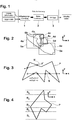
- a limitation preliminary check is carried out in a block 1, with which, from all the stored area polygons, those are selected which, because of their proximity to the current vehicle position, are candidates for an area in which the vehicle is currently located.
- the candidate area polygons identified in block 1 are successively subjected to a point-in-polygon test (PIP test) in block 3 in order to find out whether the current vehicle position is in the tested area and that as current Aptly determined area or an identifier thereof is the output variable supplied to a driver assistance system of the motor vehicle.
- PIP test point-in-polygon test
- each candidate area polygon identified in block 1 is first in block 2 by overlaying many parallel strips, which extend along a given coordinate axis, divided into smaller sub-polygons.
- the strip into which the current vehicle position falls is determined by means of a binary search, an algorithm known in the prior art, which finds a searched element very efficiently in a list.
- the partial polygons of all candidate area polygons falling into the respective strips are then subjected to a PIP test one after the other in block 1 in order to find out whether the current vehicle position is in the tested partial polygon.
- the pre-limitation check in block 1 of Fig. 1 is carried out because the number of areas to be distinguished is usually high.
- a suitable rectangular bounding box 5a, 5b, 5c, 5d, 5e is drawn around each area polygon, here only five area polygons 4a, 4b, 4c, 4d, 4e are shown.
- B. are simply given by the smallest and largest x or ⁇ coordinates of the corresponding area polygon 4a, 4b, 4c, 4d, 4e.
- All area polygons belonging to a bounding box into which the geoposition of the vehicle falls are candidate polygons, ie possible candidates for an area in which the vehicle is currently located. All other area polygons need not be checked further.
- the PIP test in block 3 of Fig. 1 is an optimized so-called beam method for checking whether a point lies inside or outside a polygon.
- the beam method draws a test beam in any direction from a point under test and counts the number of times the test beam crosses the edges of the polygon. If the number of intersections of the test beam with the polygon edges is odd, the point lies within the polygon and otherwise outside of it.
- the corresponding decision rule can be written as:
- Fig. 3 illustrates an example of a corresponding PIP test with respect to a point p which lies within a polygon P and with respect to a point p 'which lies outside the polygon P.
- the most extensive calculation steps in the beam method are the calculations of the intersection points.
- the optimized beam method proposed here works without intersection calculations using improved larger / smaller comparisons of coordinate values, as described below.
- test beam can now be defined as the positive x-axis of a Cartesian x-y coordinate system.
- Comprehensive intersection calculations can be avoided because it is not necessary to know the exact intersection point, but only whether the polygon edge intersects the positive half of the x-axis. This can be done in three simple steps as described below.
- the above calculation can also be carried out in a polar coordinate system instead of in a Cartesian x-y coordinate system.
- the optional binary strip search in block 3 of Fig. 1 is particularly suitable for cases in which the individual area polygons of a polygon map have many or very different numbers of edges.
- the area polygons or at least those with a very large number of edges are divided into smaller partial polygons, each of which contains approximately the same number of polygon edges and which are called stripes or "bins" here.
- a polygon P is broken down into smaller partial polygons by five strips B 1 to B 5 .
- edges contained in a single strip are interpreted and treated as independent polygons. In this way, area polygons that naturally have different sizes and shapes, scaled to polygons of approximately the same size. The execution of the PIP tests on smaller pieces can be better managed and the computing time is less dependent on the polygon size and shape.
- the strip into which the current vehicle position falls must be determined. This can be done by a so-called binary search, which reduces the complexity O (n) when checking n strips in chronological order for O (log n).
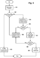
- FIG Fig. 5 also shown as a flowchart.
- the method can be started cyclically and begins in each case with step S1, a pre-limitation check as in block 1 of Fig. 1 carry out and enter identified candidate polygons in a list.
- step S2 If it is determined in step S2 that the list of candidate polygons is empty, it is output in step S3 as a result of the method that the current vehicle position is not in any area of the digital map and the method ends. Otherwise, an entry is read from the list of candidate polygons in step S4 and is searched for in block 2 of FIG Fig. 1 searched for a strip for the current vehicle position.
- step S5 it is checked whether there is a corresponding stripe, and if not, in step S6 it is caused that in step S4 the next entry, if present, is read from the list of candidate polygons and fed to step S5.
- step S5 If a stripe has been found in step S5, the partial polygon contained therein becomes the PIP test in block 3 of step S7 of Fig. 1 subjected. If it is found in step S8 that the current vehicle position is not in the sub-polygon, it returns to step S6, and if it is therein, an area code is assigned in step S9 as a result of the method, which is assigned to the area polygon in which the partial polygon is located.
Landscapes
- Engineering & Computer Science (AREA)
- Radar, Positioning & Navigation (AREA)
- Remote Sensing (AREA)
- Physics & Mathematics (AREA)
- General Physics & Mathematics (AREA)
- Automation & Control Theory (AREA)
- Computer Networks & Wireless Communication (AREA)
- Signal Processing (AREA)
- Geometry (AREA)
- Navigation (AREA)
- Traffic Control Systems (AREA)
Description
- Die Erfindung betrifft ein Verfahren, mittels numerischer Geopositionsdaten, welche die aktuelle Geoposition eines Fahrzeugs angeben, sowie digitaler Karten, die Gebietspolygone enthalten, die jeweils ein geografisches Gebiet auf der Erde repräsentieren, in dem Fahrzeug zu ermitteln, in welchem der verschiedenen Gebiete sich das Fahrzeug gerade befindet, sowie ein zur Durchführung des Verfahrens eingerichtetes Fahrzeug gemäß den Oberbegriffen der unabhängigen Patentansprüche. Ein derartiges Verfahren und Fahrzeug sind aus der
US 2014 / 0 372 024 A1 und aus derUS 2014/0 278 038 A1 bekannt. - Von den verschiedenen Fahrerassistenzsystemen in modernen Kraftfahrzeugen arbeiten einige in Abhängigkeit von dem Umfeld, in dem sich das Fahrzeug gerade befindet, und die Funktionsgenauigkeit und -verfügbarkeit derartiger Fahrerassistenzsysteme können durch Informationen von einem Navigationssystem verbessert werden, beispielsweise durch Informationen, in welchem Staat oder sonstigen geografischen Gebiet sich das Kraftfahrzeug momentan befindet, um ein länder- oder gebietsspezifisches Systemverhalten zu ermöglichen.
- Wenn ein Kraftfahrzeug ein Navigationssystem enthält, das die Geoposition des Fahrzeugs laufend mit einer digitalen Karte abgleicht, sind auch Gebietsinformationen für Fahrerassistenzsysteme leicht erhältlich, nämlich als ein Gebietscode, z. B. eine Länder-Kennung, zu der gerade befahrenen Straße.
- Navigationssysteme, die GPS-Daten nutzen, berechnen die aktuelle Fahrzeugposition sehr genau in Geokoordinaten, also als Absolutposition, und viel genauer als es zur Unterstützung von Fahrerassistenzsystemen eigentlich nötig ist.
- Navigationssysteme gehören oft nicht zur Standardausstattung von Kraftfahrzeugen, und selbst wenn dies der Fall ist, soll der Fahrer die Möglichkeit behalten, die Navigation zu deaktivieren.
- Der Erfindung liegt die Aufgabe zu Grunde, in einem Fahrzeug mit möglichst wenig Aufwand, aber ausreichender Genauigkeit zu ermitteln, in welchem geografischen Gebiet sich das Fahrzeug gerade befindet, um die Leistungsfähigkeit und Verfügbarkeit von Fahrerassistenzsystemen sicherzustellen, falls im Fahrzeug kein Navigationssystem zur Verfügung steht oder gerade nicht in Betrieb ist.
- Diese Aufgabe wird durch ein Verfahren und eine Vorrichtung mit den Merkmalen der unabhängigen Patentansprüche gelöst.
- Vorteilhafte Weiterbildungen der Erfindung sind in den abhängigen Patentansprüchen angegeben.
- Es wird zunächst eine Begrenzungs-Vorprüfung durchgeführt, wobei Kandidaten-Gebietspolygone ausgewählt werden, die in der Nähe der aktuellen Fahrzeugposition liegen. Die ausgewählten Kandidaten-Gebietspolygone werden dann nacheinander einem PIP-Test (Point-In-Polygon-Test) unterzogen, um zu ermitteln, ob sich die aktuelle Fahrzeugposition in einem der entsprechenden Gebiete befindet. Gemäß der Erfindung wird mindestens einem Fahrerassistenzsystem des Fahrzeugs eine Ausgangsgröße zugeführt, die angibt, ob und ggf. in welchem der Gebiete sich das Fahrzeug gerade befindet.
- Die Erfindung nutzt den Umstand, dass in den meisten Kraftfahrzeugen standardmäßig zumindest ein Empfänger für globale Navigationssatellitensysteme (GNSS) verbaut ist, ein Gerät, das aus den Satellitensignalen die eigene geografische Position bestimmen kann. Derartige GPS- oder verwandte Positionsbestimmungsgeräte werden mit der Einführung des automatischen Notrufsystems für Kraftfahrzeuge (eCall) sogar vorgeschrieben und nicht ohne weiteres deaktivierbar sein.
- GNSS-Geräte liefern zwar nur die absolute Geoposition als reine Zahlenwerte, doch ist es mit der Erfindung möglich, daraus mit minimalem Speicher- und Rechenaufwand Gebietsinformationen zu gewinnen, die für Fahrerassistenzsysteme genau genug sind.
- Das erfindungsgemäße Verfahren benötigt nur einen minimalen Satz von geografischen Kartendaten mit entsprechend geringem Speicherbedarf und kann als Software durchgeführt werden, die auf einer sog. "Embedded Platform" laufen kann. Die Rechenzeiten sind vorherbestimmbar und geringer als bei einer genauen Positionsbestimmung.
- Andererseits ist das erfindungsgemäße Verfahren wesentlich genauer als bloße Positionsschätzungen, aber um ein Vielfaches schneller und ressourcensparender als übliche Navigationssysteme. Letzteres liegt auch daran, dass für die Erfindung nur die Relativpositionen von Fahrzeug und Gebietspolygonen ermittelt werden müssen.
- Das erfindungsgemäße Verfahren steht in einer gewissen Verwandtschaft zu sog. Geofencing-Algorithmen, die beim Überschreiten einer gedachten Begrenzung auf der Erde eine Aktion auslösen. Die dafür genutzten Algorithmen haben aber keine vorherbestimmten Rechenzeiten und benötigen nicht so wenig Speicherplatz und sind nicht so einfach implementierbar wie die vorliegende Erfindung.
- Die
US 2001 024 203 A1 ,US 2012 123 677 A1 undUS 2007 083 325 A1 offenbaren Kartenanzeige- bzw. -bewegungsvorrichtungen, wobei aber andere Algorithmen zur Polygonverarbeitung als bei der vorliegenden Erfindung zum Einsatz kommen. Außerdem sind für die Erfindung keine Kartenanzeigevorrichtungen erforderlich. - In einer bevorzugten Ausführungsform der vorliegenden Erfindung erfolgt die Begrenzungs-Vorprüfung durch Größer/Kleiner-Vergleiche der Werte einer ersten Koordinate der aktuellen Fahrzeugposition mit den maximalen bzw. minimalen Koordinatenwerten der in den digitalen Karten enthaltenen Gebietspolygone bezüglich der ersten Koordinate sowie durch Größer/Kleiner-Vergleiche der Werte einer zweiten, zu der ersten Koordinate orthogonalen Koordinate der aktuellen Fahrzeugposition mit den maximalen bzw. minimalen Koordinatenwerten der Gebietspolygone bezüglich der zweiten Koordinate.
- In bevorzugten Ausführungsformen werden die PIP-Tests ohne Schnittpunktberechnungen mittels Größer/Kleiner-Vergleichen von Koordinatenwerten nach geeigneter Koordinatenverschiebung durchgeführt, was den Rechenaufwand wesentlich vermindert.
- Gemäß der Erfindung werden die mittels der Begrenzungs-Vorprüfung ausgewählten Kandidaten-Gebietspolygone durch Überlagern von parallelen Streifen in kleinere Teilpolygone unterteilt. Weiterhin wird mittels einer binären Suche ein Streifen ermittelt, in den die aktuelle Fahrzeugposition fällt, und die in den ermittelten Streifen fallenden Teilpolygone werden dann den PIP-Tests unterzogen. Dies senkt den Rechenaufwand noch mehr.
- Die geografischen Gebiete sind vorzugsweise administrative oder ähnliche Gebiete, welche sich nur in Ausnahmefällen ändern. Daher ist keine häufige Aktualisierung der digitalen Karten erforderlich.
- Wie beschrieben, eignet sich das erfindungsgemäße Verfahren besonders für Fahrzeuge, insbesondere Kraftfahrzeuge, worin ein Empfänger für ein globales Navigationssatellitensystem, der die Geopositionsdaten liefert, aber kein Navigationssystem eingebaut ist, und die mindestens ein Fahrerassistenzsystem aufweisen.
- Es folgt eine Beschreibung von Ausführungsbeispielen anhand der Zeichnungen. Darin zeigen:
- Fig. 1
- ein Blockdiagramm eines Verfahrens zum Ermitteln, in welchem geografischen Gebiet sich ein Fahrzeug gerade befindet;
- Fig. 2
- eine Skizze zur Erläuterung des Umgrenzung-Blocks in
Fig. 1 ; - Fig. 3
- eine Skizze zur Erläuterung des PIP-Test-Blocks in
Fig. 1 ; - Fig. 4
- eine Skizze zur Erläuterung des Streifen-Binärsuche-Blocks in
Fig. 1 ; und - Fig. 5
- ein Flussdiagramm des Verfahren zum Ermitteln, in welchem geografischen Gebiet sich das Fahrzeug gerade befindet.
- Das nachfolgend beschriebene System wird GPS-basierte Gebietserkennung genannt.
- Ein in einem Kraftfahrzeug eingebauter GNSS-Empfänger liefert Rohdaten, welche die geografischen Koordinaten des Fahrzeugs als dessen GPS-Position oder allgemein Geoposition angeben. Außerdem ist im Fahrzeug eine digitale Karte gespeichert, welche ausschließlich zusammenhängende geografische und/oder administrative Gebiete auf der Erde darstellt, und zwar als mehr oder weniger lückenlos aneinander angrenzende Polygone, welche relevante Gebietsgrenzen darstellen bzw. an diese angenähert sind.
- Auf Basis der Geopositionsdaten wird in regelmäßigen Zeitabständen, wie z. B. alle paar Sekunden, ermittelt, in welchem der geografischen oder administrativen Gebiete sich das Fahrzeug gerade befindet.
- Dazu wird das in
Fig. 1 im Überblick dargestellte Gebietserkennungsverfahren mittels im Fahrzeug vorhandener Hard- und Software durchgeführt. - Anhand der Geopositionsdaten und der Polygonkartendaten als Eingangsgrößen wird in einem Block 1 eine Begrenzungs-Vorprüfung durchgeführt, womit unter allen gespeicherten Gebietspolygonen jene ausgewählt werden, die aufgrund ihrer Nähe zu der aktuellen Fahrzeugposition Kandidaten für ein Gebiet sind, in dem sich das Fahrzeug gerade befindet.
- In einem ersten Ausführungsbeispiel werden die im Block 1 identifizierten Kandidaten-Gebietspolygone im Block 3 nacheinander einem Point-In-Polygon-Test (PIP-Test) unterzogen, um herauszufinden, ob sich die aktuelle Fahrzeugposition in dem geprüften Gebiet befindet, und das als aktuell passend ermittelte Gebiet bzw. eine Kennung desselben ist die einem Fahrerassistenzsystem des Kraftfahrzeugs zugeführte Ausgangsgröße.
- In einem zweiten Ausführungsbeispiel wird jedes im Block 1 identifizierte Kandidaten-Gebietspolygon zunächst im Block 2 durch Überlagern von vielen parallelen Streifen, die sich entlang einer vorgegebenen Koordinatenachse erstrecken, in kleinere Teilpolygone unterteilt. Mittels einer binären Suche, eines im Stand der Technik bekannten Algorithmus, der in einer Liste sehr effizient ein gesuchtes Element findet, wird jener Streifen ermittelt, in den die aktuelle Fahrzeugposition fällt. Die in die jeweiligen Streifen fallenden Teilpolygone aller Kandidaten-Gebietspolygone werden dann im Block 1 nacheinander einem PIP-Test unterzogen, um herauszufinden, ob sich die aktuelle Fahrzeugposition in dem geprüften Teilpolygon befindet.
- Die Blöcke 1 bis 3 werden nachfolgend detaillierter beschrieben.
- Die Begrenzungs-Vorprüfung im Block 1 von
Fig. 1 wird durchgeführt, da die Zahl der zu unterscheidenden Gebiete normalerweise hoch ist. Wie inFig. 2 gezeigt, wird dazu um jedes Gebietspolygon, wobei hier nur fünf Gebietspolygone 4a, 4b, 4c, 4d, 4e dargestellt sind, ein passender rechteckiger Begrenzungskasten 5a, 5b, 5c, 5d, 5e gezogen, dessen Koordinaten in einem x-y-Koordinatensystem z. B. einfach durch die kleinsten und größten x- bzw. γ-Koordinaten des entsprechenden Gebietspolygons 4a, 4b, 4c, 4d, 4e gegeben sind. - So kann auf einfachste Weise geprüft werden, in welche der Begrenzungskästen 5a, 5b, 5c, 5d, 5e die Geoposition des Fahrzeugs fällt, nämlich durch Größer/Kleiner-Vergleiche der Werte einer ersten Koordinate der aktuellen Fahrzeugposition mit den entsprechenden maximalen bzw. minimalen Koordinatenwerten der Gebietspolygone 4a, 4b, 4c, 4d, 4e sowie durch Größer/Kleiner-Vergleiche der Werte einer zweiten, zu der ersten Koordinate orthogonalen Koordinate der aktuellen Fahrzeugposition mit den entsprechenden maximalen bzw. minimalen Koordinatenwerten der Gebietspolygone 4a, 4b, 4c, 4d, 4e, wobei die Koordinaten wahlweise kartesische x-γ-Koordinaten oder Polarkoordinaten sein können.
- Alle Gebietspolygone, die zu einem Begrenzungskasten gehören, in den die Geoposition des Fahrzeugs fällt, sind Kandidaten-Polygone, d. h. mögliche Kandidaten für ein Gebiet, in dem sich das Fahrzeug gerade befindet. Alle anderen Gebietspolygone brauchen nicht weiter geprüft zu werden.
- Der PIP-Test im Block 3 von
Fig. 1 ist eine optimierte sog. Strahl-Methode zur Prüfung, ob ein Punkt innerhalb oder außerhalb eines Polygons liegt. Bei der Strahl-Methode wird von einem zu testenden Punkt aus ein Prüfstrahl in eine beliebige Richtung gezogen, und es wird gezählt, wie oft der Prüfstrahl die Kanten des Polygons schneidet. Ist die Zahl der Schnittpunkte des Prüfstrahls mit den Polygonkanten ungerade, liegt der Punkt innerhalb des Polygons, und anderenfalls außerhalb davon. Die entsprechende Entscheidungsregel lässt sich schreiben als:
-
Fig. 3 veranschaulicht ein Beispiel für einen entsprechenden PIP-Test bezüglich eines Punktes p, der innerhalb eines Polygons P liegt, sowie bezüglich eines Punktes p', der außerhalb des Polygons P liegt. Von den Punkten p und p' ausgehende Beispiel-Prüfstrahlen sind als S und S' eingezeichnet, und deren Schnittpunkte mit den Polygon-Kanten als kleine Kreise. - Die umfangreichsten Rechenschritte bei der Strahl-Methode sind die Berechnungen der Schnittpunkte. Die hier vorgeschlagene optimierte Strahl-Methode arbeitet ohne Schnittpunktberechnungen unter Verwendung von verbesserten Größer/Kleiner-Vergleichen von Koordinatenwerten, wie nachfolgend beschrieben.
- Zuerst wird das Koordinatensystem so verschoben, dass die aktuelle Position des Fahrzeugs im Ursprung liegt. Der Prüfstrahl kann nun als die positive x-Achse eines kartesischen x-y-Koordinatensystems definiert werden. Umfangreiche Schnittpunktberechnungen können vermieden werden, da es nicht notwendig ist, den exakten Schnittpunkt zu kennen, sondern nur, ob die Polygon-Kante die positive Hälfte der x-Achse schneidet. Dies kann in drei einfachen Schritten durchgeführt werden, wie nachfolgend beschrieben.
- Es seien vi =(xi, yi) und vj = (xj, yj) die verschobenen Scheitelpunkte der geprüften Polygon-Kante. Eine Innerhalb/Außerhalb-Bedingung kann wie folgt formuliert werden:
- 1) Verwerfe alle Kanten, die nicht die folgende Bedingung erfüllen:
sign (yi) ≠ sign (yj) - 2a) Speichere das Auftreten eines Schnittpunkts, wenn eine Kante die folgende Bedingung erfüllt:
sign (xi) > 0 && sign (xj) >0 - 2b) Die Kante ist zu verwerfen, wenn:
sign (xi) <0 && sign (xj)<0 - 3) Speichere das Auftreten eines Schnittpunkts für Kanten mit, wobei b der y-Achsen-Abschnitt der Kante im verschobenen Koordinatensystem ist:

- Mit den Größer/Kleiner-Vergleichen ist der durchgeführte PIP-Test sehr effizient. Es bleibt nur eine Division (bei der Berechnung von b) übrig.
- Die obige Berechnung kann statt in einem kartesischen x-y-Koordinatensystem auch in einem Polarkoordinatensystem durchgeführt werden.
- Die optionale binäre Streifensuche im Block 3 von
Fig. 1 eignet sich besonders für Fälle, in denen die einzelnen Gebietspolygone einer Polygonkarte sehr viele oder sehr unterschiedlich viele Kanten aufweisen. Dazu werden die Gebietspolygone oder zumindest solche mit sehr vielen Kanten in kleinere Teilpolygone unterteilt, die jeweils ungefähr die gleiche Zahl von Polygon-Kanten enthalten und die hier Streifen oder "Bins" genannt werden. In dem inFig. 4 gezeigten Beispiel wird ein Polygon P durch fünf Streifen B1 bis B5 in kleinere Teilpolygone zerlegt. - Die in einem einzelnen Streifen enthaltenen Kanten werden als unabhängige Polygone interpretiert und behandelt. Auf diese Weise werden Gebietspolygone, die natürlicherweise unterschiedliche Größen und Formen haben, auf Polygone von ungefähr gleicher Größe skaliert. Die Durchführung der PIP-Tests an kleineren Stücken kann besser verwaltet werden, und die Rechenzeit ist weniger abhängig von der Polygongröße und -form.
- Vor Durchführung der PIP-Tests bzw. Schnittpunkt-Tests muss der Streifen ermittelt werden, in den die aktuelle Fahrzeugposition fällt. Dies kann durch eine sog. binäre Suche geschehen, welche die Komplexität O (n) beim Prüfen von n Streifen in chronologischer Reihenfolge auf O (log n) vermindert.
- Das zweite Ausführungsbeispiel des Verfahrens zum Ermitteln, in welchem geografischen Gebiet sich ein Fahrzeug gerade befindet, ist in
Fig. 5 auch als Flussdiagramm dargestellt. Das Verfahren wird kann zyklisch gestartet werden und beginnt jeweils mit dem Schritt S1, eine Begrenzungs-Vorprüfung wie im Block 1 vonFig. 1 durchzuführen und ermittelte Kandidaten-Polygone in eine Liste einzutragen. - Wenn im Schritt S2 festgestellt wird, dass die Liste von Kandidaten-Polygonen leer ist, wird im Schritt S3 als Ergebnis des Verfahrens ausgegeben, dass sich die aktuelle Fahrzeugposition in keinem Gebiet der digitalen Karte befindet, und das Verfahren endet. Andernfalls wird im Schritt S4 ein Eintrag aus der Liste von Kandidaten-Polygonen ausgelesen und wird mittels der binären Streifensuche im Block 2 von
Fig. 1 nach einem Streifen für die aktuelle Fahrzeugposition gesucht. - Im Schritt S5 wird geprüft, ob es einen entsprechenden Streifen gibt, und wenn nicht, wird im Schritt S6 bewirkt, dass im Schritt S4 der nächste Eintrag, falls vorhanden, aus der Liste von Kandidaten-Polygonen ausgelesen und dem Schritt S5 zugeführt wird.
- Wenn im Schritt S5 ein Streifen gefunden worden ist, wird im Schritt S7 das darin enthaltene Teilpolygon dem PIP-Test im Block 3 von
Fig. 1 unterzogen. Wenn sich im Schritt S8 zeigt, dass die aktuelle Fahrzeugposition nicht in dem Teilpolygon liegt, geht es zum Schritt S6 zurück, und wenn es darin liegt, wird im Schritt S9 als Ergebnis des Verfahrens ein Gebietscode ausgegeben, der dem Gebietspolygon zugeordnet ist, in dem sich das Teilpolygon befindet.
Claims (6)
- Verfahren, mittels numerischer Geopositionsdaten, welche die aktuelle Geoposition eines Fahrzeugs angeben, sowie digitaler Karten, die Gebietspolygone enthalten, die jeweils ein geografisches Gebiet auf der Erde repräsentieren, in dem Fahrzeug zu ermitteln, in welchem der verschiedenen Gebiete sich das Fahrzeug gerade befindet, wobei
eine Begrenzungs-Vorprüfung durchgeführt wird, wobei Kandidaten-Gebietspolygone ausgewählt werden, die in der Nähe der aktuellen Fahrzeugposition liegen (1); und
die ausgewählten Kandidaten-Gebietspolygone nacheinander einem PIP-Test unterzogen werden (3), um zu ermitteln, ob sich die aktuelle Fahrzeugposition in einem der entsprechenden Gebiete befindet;
dadurch gekennzeichnet, dass
die mittels der Begrenzungs-Vorprüfung ausgewählten Kandidaten-Gebietspolygone durch Überlagern von parallelen Streifen in kleinere Teilpolygone unterteilt werden, dass mittels einer binären Suche ein Streifen ermittelt wird, in den die aktuelle Fahrzeugposition fällt, und dass nur die dem ermittelten Streifen entsprechenden Teilpolygone den PIP-Tests unterzogen werden;
und dass eine Ausgangsgröße, die angibt, ob und ggf. in welchem der Gebiete sich das Fahrzeug gerade befindet, mindestens einem Fahrerassistenzsystem des Fahrzeugs zugeführt wird. - Verfahren nach Anspruch 1,
dadurch gekennzeichnet, dass
die Begrenzungs-Vorprüfung mittels Größer/Kleiner-Vergleichen der Werte einer ersten Koordinate der aktuellen Fahrzeugposition mit den maximalen bzw. minimalen Koordinatenwerten der Gebietspolygone bezüglich der ersten Koordinate sowie mittels Größer/Kleiner-Vergleichen der Werte einer zweiten, zu der ersten Koordinate orthogonalen Koordinate der aktuellen Fahrzeugposition mit den maximalen bzw. minimalen Koordinatenwerten der Gebietspolygone bezüglich der zweiten Koordinate durchgeführt wird. - Verfahren nach Anspruch 1 oder 2,
dadurch gekennzeichnet, dass
die PIP-Tests ohne Schnittpunktberechnungen mittels Größer/Kleiner-Vergleichen von Koordinatenwerten nach geeigneter Koordinatenverschiebung durchgeführt werden. - Verfahren nach einem der vorhergehenden Ansprüche,
dadurch gekennzeichnet, dass
die geografischen Gebiete administrative Gebiete sind. - Verfahren nach einem der vorhergehenden Ansprüche,
dadurch gekennzeichnet, dass
das Fahrzeug ein Kraftfahrzeug ist. - Fahrzeug, insbesondere Kraftfahrzeug, in dem ein die Geopositionsdaten liefernder Empfänger für ein globales Navigationssatellitensystem, aber kein Navigationssystem eingebaut ist und das mindestens ein Fahrerassistenzsystem aufweist,
dadurch gekennzeichnet, dass
das Fahrzeug dafür eingerichtet ist, das Verfahren nach einem der vorhergehenden Ansprüche durchzuführen.
Applications Claiming Priority (1)
| Application Number | Priority Date | Filing Date | Title |
|---|---|---|---|
| DE102016204823.6A DE102016204823A1 (de) | 2016-03-23 | 2016-03-23 | GPS-basierte Gebietserkennung in Fahrzeugen |
Publications (2)
| Publication Number | Publication Date |
|---|---|
| EP3228988A1 EP3228988A1 (de) | 2017-10-11 |
| EP3228988B1 true EP3228988B1 (de) | 2020-05-06 |
Family
ID=58261588
Family Applications (1)
| Application Number | Title | Priority Date | Filing Date |
|---|---|---|---|
| EP17159608.3A Active EP3228988B1 (de) | 2016-03-23 | 2017-03-07 | Gps-basierte gebietserkennung in fahrzeugen |
Country Status (3)
| Country | Link |
|---|---|
| US (1) | US10935384B2 (de) |
| EP (1) | EP3228988B1 (de) |
| DE (1) | DE102016204823A1 (de) |
Families Citing this family (10)
| Publication number | Priority date | Publication date | Assignee | Title |
|---|---|---|---|---|
| US10593074B1 (en) * | 2016-03-16 | 2020-03-17 | Liberty Mutual Insurance Company | Interactive user interface for displaying geographic boundaries |
| DE102019200494B4 (de) | 2019-01-16 | 2022-12-22 | Audi Ag | Kraftfahrzeug mit wenigstens einem Radarsensor und Verfahren zum Betrieb eines Radarsensors in einem Kraftfahrzeug |
| CN109557942B (zh) * | 2019-01-21 | 2021-10-26 | 梁晓龙 | 一种自主飞行的无人机地理围栏算法 |
| CN109918468A (zh) * | 2019-03-21 | 2019-06-21 | 四川长虹电器股份有限公司 | 基于墨卡托投影的物联网设备位置数据区域筛选方法 |
| US11392128B1 (en) * | 2019-04-19 | 2022-07-19 | Zoox, Inc. | Vehicle control using directed graphs |
| DE102020211392A1 (de) | 2020-03-26 | 2021-09-30 | Continental Teves Ag & Co. Ohg | Verfahren zur Erfassung einer Eigenposition bezüglich eines Grenzverlaufs und elektronisches Kontrollsystem |
| CN112857376A (zh) * | 2021-01-12 | 2021-05-28 | 广州小鹏自动驾驶科技有限公司 | 一种车辆道路匹配的方法和装置 |
| CN115240401B (zh) * | 2022-07-04 | 2024-04-09 | 一汽解放汽车有限公司 | 车辆位置确定方法、装置、设备、介质和产品 |
| CN115240429B (zh) * | 2022-08-11 | 2023-02-14 | 深圳市城市交通规划设计研究中心股份有限公司 | 一种人车流量统计方法、电子设备及存储介质 |
| DE102022120808B3 (de) | 2022-08-17 | 2023-10-26 | Audi Aktiengesellschaft | Verfahren zum Absetzen eines Notrufs |
Family Cites Families (16)
| Publication number | Priority date | Publication date | Assignee | Title |
|---|---|---|---|---|
| US5948043A (en) | 1996-11-08 | 1999-09-07 | Etak, Inc. | Navigation system using GPS data |
| JP3912476B2 (ja) | 2000-03-21 | 2007-05-09 | アイシン・エィ・ダブリュ株式会社 | 地図表示装置 |
| JP2007108257A (ja) | 2005-10-11 | 2007-04-26 | Alpine Electronics Inc | 地図移動装置 |
| SG171974A1 (en) | 2008-12-26 | 2011-07-28 | Jx Nippon Mining & Metals Corp | Flexible laminate and flexible electronic circuit substrate formed using the same |
| US8150620B2 (en) * | 2009-04-14 | 2012-04-03 | Alpine Electronics, Inc. | Route search method and apparatus for navigation system utilizing map data of XML format |
| JP4885336B2 (ja) | 2010-02-12 | 2012-02-29 | 三菱電機株式会社 | 地図表示装置 |
| US8810437B2 (en) * | 2011-02-02 | 2014-08-19 | Mapquest, Inc. | Systems and methods for generating electronic map displays with points-of-interest information based on reference locations |
| US9786176B2 (en) * | 2012-06-22 | 2017-10-10 | Zonal Systems, Llc | System and method for placing virtual geographic zone markers |
| US9121719B2 (en) * | 2013-03-15 | 2015-09-01 | Abalta Technologies, Inc. | Vehicle range projection |
| US9456302B2 (en) * | 2013-06-03 | 2016-09-27 | Temeda Llc | Geospatial asset tracking systems, methods and apparatus for acquiring, manipulating and presenting telematic metadata |
| KR101493817B1 (ko) * | 2013-06-14 | 2015-03-02 | 현대엠엔소프트 주식회사 | 사용자 단말의 맵매칭 방법 |
| US9074894B2 (en) * | 2013-07-08 | 2015-07-07 | GM Global Technology Operations LLC | Vehicle range projection estimation |
| US9558584B1 (en) * | 2013-07-29 | 2017-01-31 | Google Inc. | 3D position estimation of objects from a monocular camera using a set of known 3D points on an underlying surface |
| JP6382688B2 (ja) * | 2014-11-06 | 2018-08-29 | 日立建機株式会社 | 地図生成装置 |
| US10386844B2 (en) * | 2015-09-30 | 2019-08-20 | Deere & Company | System and method for using geo-fenced guidance lines |
| US10795351B2 (en) * | 2016-07-19 | 2020-10-06 | Raven Industries, Inc. | System and method for autonomous control of agricultural machinery and equipment |
-
2016
- 2016-03-23 DE DE102016204823.6A patent/DE102016204823A1/de not_active Withdrawn
-
2017
- 2017-03-07 EP EP17159608.3A patent/EP3228988B1/de active Active
- 2017-03-14 US US15/458,451 patent/US10935384B2/en active Active
Non-Patent Citations (1)
| Title |
|---|
| None * |
Also Published As
| Publication number | Publication date |
|---|---|
| EP3228988A1 (de) | 2017-10-11 |
| US10935384B2 (en) | 2021-03-02 |
| DE102016204823A1 (de) | 2017-09-28 |
| US20170276490A1 (en) | 2017-09-28 |
| US20200333143A9 (en) | 2020-10-22 |
Similar Documents
| Publication | Publication Date | Title |
|---|---|---|
| EP3228988A1 (de) | Gps-basierte gebietserkennung in fahrzeugen | |
| EP3740738B1 (de) | Verfahren zur positionsbestimmung eines fahrzeugs | |
| DE102015214338A1 (de) | Bestimmung einer Anordnungsinformation für ein Fahrzeug | |
| DE102017206436A1 (de) | Verfahren zur Erkennung und/oder Verfolgung von Objekten | |
| DE102014212866A1 (de) | Verfahren zum Ermitteln eines Parkplatzes aus einer Anzahl von Messpunkten | |
| EP3289578B1 (de) | Analyse der belegung von grid-basierten umfeldkarten eines fahrzeugs | |
| EP3980724A1 (de) | Verfahren zum erstellen einer universell einsetzbaren merkmalskarte | |
| DE112017001917T5 (de) | Kartendaten-Erzeugungssystem und Verfahren zur Erzeugung von Kartendaten | |
| DE102015001247A1 (de) | Verfahren zur Bereitstellung von Information über zumindest ein Objekt in einem Umgebungsbereich eines Kraftfahrzeugs und System | |
| DE102017211607A1 (de) | Verfahren zur Verifizierung einer digitalen Karte eines höher automatisierten Fahrzeugs (HAF), insbesondere eines hochautomatisierten Fahrzeugs | |
| DE102016216154A1 (de) | Verfahren und Auswerteeinheit zur Ermittlung der Position von Verkehrszeichen | |
| WO2019068827A1 (de) | Verfahren zum betrieb eines navigationssystems | |
| DE102017208509A1 (de) | Verfahren zum Erzeugen eines Straßenmodells während einer Fahrt eines Kraftfahrzeugs sowie Steuervorrichtung und Kraftfahrzeug | |
| DE112020003817T5 (de) | Belegungsgitterkarten-managementvorrichtung | |
| DE102019001450A1 (de) | Verfahren zur Bereitstellung von Daten zur Lokalisierung eines Fahrzeugs | |
| DE102016206631A1 (de) | Vorrichtung zur Datenfusion von Messdaten für eine Generierung eines räumlichen Belegungsrasters für ein Kraftfahrzeug | |
| EP4153943A1 (de) | Verfahren zum ermitteln einer ausgangspose eines fahrzeugs | |
| DE102019000617A1 (de) | Verfahren zur automatischen Erkennung mindestens einer Verkehrsstörung auf einer Route eines Fahrzeugs, Navigationssystem zum Ausführen eines solchen Verfahrens, sowie Fahrzeug mit einem solchen Navigationssystem | |
| DE112018007624T5 (de) | Fahrassistenzeinrichtung, fahrassistenzverfahren und fahrassistenzprogramm | |
| DE102023112926B4 (de) | Computer-implementiertes Verfahren zur kartenbasierten Lokalisierung eines Navigationssystems in einem Kraftfahrzeug, Navigationssystem, Computerprogramm, computerlesbares Speichermedium und Kraftfahrzeug | |
| DE102016223107A1 (de) | System und Verfahren zur Schätzung der Eigenbewegung eines Fahrzeuges | |
| EP3755972B1 (de) | Erstellen einer geographischen karte | |
| DE102019206336A1 (de) | Verfahren und Vorrichtung zum Erstellen einer ersten Karte | |
| DE102022214329A1 (de) | Verfahren und Vorrichtung zum Aktualisieren und Bereitstellen einer Karte | |
| DE102020116027A1 (de) | Verfahren und Vorrichtung zur Ermittlung von Belegungsinformation für einen Umfeldpunkt auf Basis von Radardetektionen |
Legal Events
| Date | Code | Title | Description |
|---|---|---|---|
| PUAI | Public reference made under article 153(3) epc to a published international application that has entered the european phase |
Free format text: ORIGINAL CODE: 0009012 |
|
| STAA | Information on the status of an ep patent application or granted ep patent |
Free format text: STATUS: THE APPLICATION HAS BEEN PUBLISHED |
|
| AK | Designated contracting states |
Kind code of ref document: A1 Designated state(s): AL AT BE BG CH CY CZ DE DK EE ES FI FR GB GR HR HU IE IS IT LI LT LU LV MC MK MT NL NO PL PT RO RS SE SI SK SM TR |
|
| AX | Request for extension of the european patent |
Extension state: BA ME |
|
| STAA | Information on the status of an ep patent application or granted ep patent |
Free format text: STATUS: REQUEST FOR EXAMINATION WAS MADE |
|
| 17P | Request for examination filed |
Effective date: 20180411 |
|
| RBV | Designated contracting states (corrected) |
Designated state(s): AL AT BE BG CH CY CZ DE DK EE ES FI FR GB GR HR HU IE IS IT LI LT LU LV MC MK MT NL NO PL PT RO RS SE SI SK SM TR |
|
| GRAP | Despatch of communication of intention to grant a patent |
Free format text: ORIGINAL CODE: EPIDOSNIGR1 |
|
| STAA | Information on the status of an ep patent application or granted ep patent |
Free format text: STATUS: GRANT OF PATENT IS INTENDED |
|
| RIC1 | Information provided on ipc code assigned before grant |
Ipc: H04W 4/021 20180101ALI20191212BHEP Ipc: G01C 21/20 20060101AFI20191212BHEP Ipc: G01C 21/34 20060101ALI20191212BHEP Ipc: G01C 21/30 20060101ALI20191212BHEP |
|
| RIC1 | Information provided on ipc code assigned before grant |
Ipc: G01C 21/30 20060101ALI20191220BHEP Ipc: H04W 4/021 20180101ALI20191220BHEP Ipc: G01C 21/20 20060101AFI20191220BHEP |
|
| INTG | Intention to grant announced |
Effective date: 20200114 |
|
| RIN1 | Information on inventor provided before grant (corrected) |
Inventor name: STRACKBEIN, MARIA Inventor name: PULATHANELI, TIMUR Inventor name: ROSENBERG, STEPHANIE Inventor name: HAASE, SASCHA |
|
| GRAS | Grant fee paid |
Free format text: ORIGINAL CODE: EPIDOSNIGR3 |
|
| GRAA | (expected) grant |
Free format text: ORIGINAL CODE: 0009210 |
|
| STAA | Information on the status of an ep patent application or granted ep patent |
Free format text: STATUS: THE PATENT HAS BEEN GRANTED |
|
| AK | Designated contracting states |
Kind code of ref document: B1 Designated state(s): AL AT BE BG CH CY CZ DE DK EE ES FI FR GB GR HR HU IE IS IT LI LT LU LV MC MK MT NL NO PL PT RO RS SE SI SK SM TR |
|
| REG | Reference to a national code |
Ref country code: GB Ref legal event code: FG4D Free format text: NOT ENGLISH |
|
| REG | Reference to a national code |
Ref country code: CH Ref legal event code: EP Ref country code: AT Ref legal event code: REF Ref document number: 1267480 Country of ref document: AT Kind code of ref document: T Effective date: 20200515 |
|
| REG | Reference to a national code |
Ref country code: IE Ref legal event code: FG4D Free format text: LANGUAGE OF EP DOCUMENT: GERMAN |
|
| REG | Reference to a national code |
Ref country code: DE Ref legal event code: R096 Ref document number: 502017005094 Country of ref document: DE |
|
| REG | Reference to a national code |
Ref country code: LT Ref legal event code: MG4D |
|
| REG | Reference to a national code |
Ref country code: NL Ref legal event code: MP Effective date: 20200506 |
|
| PG25 | Lapsed in a contracting state [announced via postgrant information from national office to epo] |
Ref country code: SE Free format text: LAPSE BECAUSE OF FAILURE TO SUBMIT A TRANSLATION OF THE DESCRIPTION OR TO PAY THE FEE WITHIN THE PRESCRIBED TIME-LIMIT Effective date: 20200506 Ref country code: LT Free format text: LAPSE BECAUSE OF FAILURE TO SUBMIT A TRANSLATION OF THE DESCRIPTION OR TO PAY THE FEE WITHIN THE PRESCRIBED TIME-LIMIT Effective date: 20200506 Ref country code: NO Free format text: LAPSE BECAUSE OF FAILURE TO SUBMIT A TRANSLATION OF THE DESCRIPTION OR TO PAY THE FEE WITHIN THE PRESCRIBED TIME-LIMIT Effective date: 20200806 Ref country code: GR Free format text: LAPSE BECAUSE OF FAILURE TO SUBMIT A TRANSLATION OF THE DESCRIPTION OR TO PAY THE FEE WITHIN THE PRESCRIBED TIME-LIMIT Effective date: 20200807 Ref country code: IS Free format text: LAPSE BECAUSE OF FAILURE TO SUBMIT A TRANSLATION OF THE DESCRIPTION OR TO PAY THE FEE WITHIN THE PRESCRIBED TIME-LIMIT Effective date: 20200906 Ref country code: PT Free format text: LAPSE BECAUSE OF FAILURE TO SUBMIT A TRANSLATION OF THE DESCRIPTION OR TO PAY THE FEE WITHIN THE PRESCRIBED TIME-LIMIT Effective date: 20200907 Ref country code: FI Free format text: LAPSE BECAUSE OF FAILURE TO SUBMIT A TRANSLATION OF THE DESCRIPTION OR TO PAY THE FEE WITHIN THE PRESCRIBED TIME-LIMIT Effective date: 20200506 |
|
| PG25 | Lapsed in a contracting state [announced via postgrant information from national office to epo] |
Ref country code: HR Free format text: LAPSE BECAUSE OF FAILURE TO SUBMIT A TRANSLATION OF THE DESCRIPTION OR TO PAY THE FEE WITHIN THE PRESCRIBED TIME-LIMIT Effective date: 20200506 Ref country code: LV Free format text: LAPSE BECAUSE OF FAILURE TO SUBMIT A TRANSLATION OF THE DESCRIPTION OR TO PAY THE FEE WITHIN THE PRESCRIBED TIME-LIMIT Effective date: 20200506 Ref country code: BG Free format text: LAPSE BECAUSE OF FAILURE TO SUBMIT A TRANSLATION OF THE DESCRIPTION OR TO PAY THE FEE WITHIN THE PRESCRIBED TIME-LIMIT Effective date: 20200806 Ref country code: RS Free format text: LAPSE BECAUSE OF FAILURE TO SUBMIT A TRANSLATION OF THE DESCRIPTION OR TO PAY THE FEE WITHIN THE PRESCRIBED TIME-LIMIT Effective date: 20200506 |
|
| PG25 | Lapsed in a contracting state [announced via postgrant information from national office to epo] |
Ref country code: NL Free format text: LAPSE BECAUSE OF FAILURE TO SUBMIT A TRANSLATION OF THE DESCRIPTION OR TO PAY THE FEE WITHIN THE PRESCRIBED TIME-LIMIT Effective date: 20200506 Ref country code: AL Free format text: LAPSE BECAUSE OF FAILURE TO SUBMIT A TRANSLATION OF THE DESCRIPTION OR TO PAY THE FEE WITHIN THE PRESCRIBED TIME-LIMIT Effective date: 20200506 |
|
| PG25 | Lapsed in a contracting state [announced via postgrant information from national office to epo] |
Ref country code: IT Free format text: LAPSE BECAUSE OF FAILURE TO SUBMIT A TRANSLATION OF THE DESCRIPTION OR TO PAY THE FEE WITHIN THE PRESCRIBED TIME-LIMIT Effective date: 20200506 Ref country code: RO Free format text: LAPSE BECAUSE OF FAILURE TO SUBMIT A TRANSLATION OF THE DESCRIPTION OR TO PAY THE FEE WITHIN THE PRESCRIBED TIME-LIMIT Effective date: 20200506 Ref country code: CZ Free format text: LAPSE BECAUSE OF FAILURE TO SUBMIT A TRANSLATION OF THE DESCRIPTION OR TO PAY THE FEE WITHIN THE PRESCRIBED TIME-LIMIT Effective date: 20200506 Ref country code: ES Free format text: LAPSE BECAUSE OF FAILURE TO SUBMIT A TRANSLATION OF THE DESCRIPTION OR TO PAY THE FEE WITHIN THE PRESCRIBED TIME-LIMIT Effective date: 20200506 Ref country code: DK Free format text: LAPSE BECAUSE OF FAILURE TO SUBMIT A TRANSLATION OF THE DESCRIPTION OR TO PAY THE FEE WITHIN THE PRESCRIBED TIME-LIMIT Effective date: 20200506 Ref country code: SM Free format text: LAPSE BECAUSE OF FAILURE TO SUBMIT A TRANSLATION OF THE DESCRIPTION OR TO PAY THE FEE WITHIN THE PRESCRIBED TIME-LIMIT Effective date: 20200506 Ref country code: EE Free format text: LAPSE BECAUSE OF FAILURE TO SUBMIT A TRANSLATION OF THE DESCRIPTION OR TO PAY THE FEE WITHIN THE PRESCRIBED TIME-LIMIT Effective date: 20200506 |
|
| REG | Reference to a national code |
Ref country code: DE Ref legal event code: R097 Ref document number: 502017005094 Country of ref document: DE |
|
| PG25 | Lapsed in a contracting state [announced via postgrant information from national office to epo] |
Ref country code: SK Free format text: LAPSE BECAUSE OF FAILURE TO SUBMIT A TRANSLATION OF THE DESCRIPTION OR TO PAY THE FEE WITHIN THE PRESCRIBED TIME-LIMIT Effective date: 20200506 Ref country code: PL Free format text: LAPSE BECAUSE OF FAILURE TO SUBMIT A TRANSLATION OF THE DESCRIPTION OR TO PAY THE FEE WITHIN THE PRESCRIBED TIME-LIMIT Effective date: 20200506 |
|
| PLBE | No opposition filed within time limit |
Free format text: ORIGINAL CODE: 0009261 |
|
| STAA | Information on the status of an ep patent application or granted ep patent |
Free format text: STATUS: NO OPPOSITION FILED WITHIN TIME LIMIT |
|
| 26N | No opposition filed |
Effective date: 20210209 |
|
| PG25 | Lapsed in a contracting state [announced via postgrant information from national office to epo] |
Ref country code: SI Free format text: LAPSE BECAUSE OF FAILURE TO SUBMIT A TRANSLATION OF THE DESCRIPTION OR TO PAY THE FEE WITHIN THE PRESCRIBED TIME-LIMIT Effective date: 20200506 |
|
| PG25 | Lapsed in a contracting state [announced via postgrant information from national office to epo] |
Ref country code: MC Free format text: LAPSE BECAUSE OF FAILURE TO SUBMIT A TRANSLATION OF THE DESCRIPTION OR TO PAY THE FEE WITHIN THE PRESCRIBED TIME-LIMIT Effective date: 20200506 |
|
| REG | Reference to a national code |
Ref country code: CH Ref legal event code: PL |
|
| GBPC | Gb: european patent ceased through non-payment of renewal fee |
Effective date: 20210307 |
|
| REG | Reference to a national code |
Ref country code: BE Ref legal event code: MM Effective date: 20210331 |
|
| PG25 | Lapsed in a contracting state [announced via postgrant information from national office to epo] |
Ref country code: GB Free format text: LAPSE BECAUSE OF NON-PAYMENT OF DUE FEES Effective date: 20210307 Ref country code: IE Free format text: LAPSE BECAUSE OF NON-PAYMENT OF DUE FEES Effective date: 20210307 Ref country code: FR Free format text: LAPSE BECAUSE OF NON-PAYMENT OF DUE FEES Effective date: 20210331 Ref country code: LU Free format text: LAPSE BECAUSE OF NON-PAYMENT OF DUE FEES Effective date: 20210307 Ref country code: LI Free format text: LAPSE BECAUSE OF NON-PAYMENT OF DUE FEES Effective date: 20210331 Ref country code: CH Free format text: LAPSE BECAUSE OF NON-PAYMENT OF DUE FEES Effective date: 20210331 |
|
| PG25 | Lapsed in a contracting state [announced via postgrant information from national office to epo] |
Ref country code: BE Free format text: LAPSE BECAUSE OF NON-PAYMENT OF DUE FEES Effective date: 20210331 |
|
| REG | Reference to a national code |
Ref country code: AT Ref legal event code: MM01 Ref document number: 1267480 Country of ref document: AT Kind code of ref document: T Effective date: 20220307 |
|
| PG25 | Lapsed in a contracting state [announced via postgrant information from national office to epo] |
Ref country code: HU Free format text: LAPSE BECAUSE OF FAILURE TO SUBMIT A TRANSLATION OF THE DESCRIPTION OR TO PAY THE FEE WITHIN THE PRESCRIBED TIME-LIMIT; INVALID AB INITIO Effective date: 20170307 |
|
| PG25 | Lapsed in a contracting state [announced via postgrant information from national office to epo] |
Ref country code: CY Free format text: LAPSE BECAUSE OF FAILURE TO SUBMIT A TRANSLATION OF THE DESCRIPTION OR TO PAY THE FEE WITHIN THE PRESCRIBED TIME-LIMIT Effective date: 20200506 |
|
| P01 | Opt-out of the competence of the unified patent court (upc) registered |
Effective date: 20230620 |
|
| PG25 | Lapsed in a contracting state [announced via postgrant information from national office to epo] |
Ref country code: AT Free format text: LAPSE BECAUSE OF NON-PAYMENT OF DUE FEES Effective date: 20220307 |
|
| PG25 | Lapsed in a contracting state [announced via postgrant information from national office to epo] |
Ref country code: MK Free format text: LAPSE BECAUSE OF FAILURE TO SUBMIT A TRANSLATION OF THE DESCRIPTION OR TO PAY THE FEE WITHIN THE PRESCRIBED TIME-LIMIT Effective date: 20200506 |
|
| PG25 | Lapsed in a contracting state [announced via postgrant information from national office to epo] |
Ref country code: TR Free format text: LAPSE BECAUSE OF FAILURE TO SUBMIT A TRANSLATION OF THE DESCRIPTION OR TO PAY THE FEE WITHIN THE PRESCRIBED TIME-LIMIT Effective date: 20200506 |
|
| PG25 | Lapsed in a contracting state [announced via postgrant information from national office to epo] |
Ref country code: MT Free format text: LAPSE BECAUSE OF FAILURE TO SUBMIT A TRANSLATION OF THE DESCRIPTION OR TO PAY THE FEE WITHIN THE PRESCRIBED TIME-LIMIT Effective date: 20200506 |
|
| PGFP | Annual fee paid to national office [announced via postgrant information from national office to epo] |
Ref country code: DE Payment date: 20260213 Year of fee payment: 10 |