EP3151080A1 - Unbemanntes luftfahrzeug und verfahren zur sicheren landung eines unbemannten luftfahrzeugs - Google Patents
Unbemanntes luftfahrzeug und verfahren zur sicheren landung eines unbemannten luftfahrzeugs Download PDFInfo
- Publication number
- EP3151080A1 EP3151080A1 EP16002043.4A EP16002043A EP3151080A1 EP 3151080 A1 EP3151080 A1 EP 3151080A1 EP 16002043 A EP16002043 A EP 16002043A EP 3151080 A1 EP3151080 A1 EP 3151080A1
- Authority
- EP
- European Patent Office
- Prior art keywords
- aircraft
- landing
- unmanned aerial
- aerial vehicle
- flight
- Prior art date
- Legal status (The legal status is an assumption and is not a legal conclusion. Google has not performed a legal analysis and makes no representation as to the accuracy of the status listed.)
- Granted
Links
Images


Classifications
-
- G—PHYSICS
- G05—CONTROLLING; REGULATING
- G05D—SYSTEMS FOR CONTROLLING OR REGULATING NON-ELECTRIC VARIABLES
- G05D1/00—Control of position, course, altitude or attitude of land, water, air or space vehicles, e.g. using automatic pilots
-
- G—PHYSICS
- G05—CONTROLLING; REGULATING
- G05D—SYSTEMS FOR CONTROLLING OR REGULATING NON-ELECTRIC VARIABLES
- G05D1/00—Control of position, course, altitude or attitude of land, water, air or space vehicles, e.g. using automatic pilots
- G05D1/0011—Control of position, course, altitude or attitude of land, water, air or space vehicles, e.g. using automatic pilots associated with a remote control arrangement
- G05D1/0022—Control of position, course, altitude or attitude of land, water, air or space vehicles, e.g. using automatic pilots associated with a remote control arrangement characterised by the communication link
-
- G—PHYSICS
- G05—CONTROLLING; REGULATING
- G05D—SYSTEMS FOR CONTROLLING OR REGULATING NON-ELECTRIC VARIABLES
- G05D1/00—Control of position, course, altitude or attitude of land, water, air or space vehicles, e.g. using automatic pilots
- G05D1/04—Control of altitude or depth
- G05D1/06—Rate of change of altitude or depth
- G05D1/0607—Rate of change of altitude or depth specially adapted for aircraft
- G05D1/0653—Rate of change of altitude or depth specially adapted for aircraft during a phase of take-off or landing
- G05D1/0676—Rate of change of altitude or depth specially adapted for aircraft during a phase of take-off or landing specially adapted for landing
-
- G—PHYSICS
- G08—SIGNALLING
- G08G—TRAFFIC CONTROL SYSTEMS
- G08G5/00—Traffic control systems for aircraft
- G08G5/20—Arrangements for acquiring, generating, sharing or displaying traffic information
- G08G5/26—Transmission of traffic-related information between aircraft and ground stations
-
- G—PHYSICS
- G08—SIGNALLING
- G08G—TRAFFIC CONTROL SYSTEMS
- G08G5/00—Traffic control systems for aircraft
- G08G5/30—Flight plan management
-
- G—PHYSICS
- G08—SIGNALLING
- G08G—TRAFFIC CONTROL SYSTEMS
- G08G5/00—Traffic control systems for aircraft
- G08G5/30—Flight plan management
- G08G5/34—Flight plan management for flight plan modification
-
- G—PHYSICS
- G08—SIGNALLING
- G08G—TRAFFIC CONTROL SYSTEMS
- G08G5/00—Traffic control systems for aircraft
- G08G5/50—Navigation or guidance aids
- G08G5/51—Navigation or guidance aids for control when on the ground, e.g. taxiing or rolling
-
- G—PHYSICS
- G08—SIGNALLING
- G08G—TRAFFIC CONTROL SYSTEMS
- G08G5/00—Traffic control systems for aircraft
- G08G5/50—Navigation or guidance aids
- G08G5/54—Navigation or guidance aids for approach or landing
-
- G—PHYSICS
- G08—SIGNALLING
- G08G—TRAFFIC CONTROL SYSTEMS
- G08G5/00—Traffic control systems for aircraft
- G08G5/50—Navigation or guidance aids
- G08G5/55—Navigation or guidance aids for a single aircraft
-
- G—PHYSICS
- G08—SIGNALLING
- G08G—TRAFFIC CONTROL SYSTEMS
- G08G5/00—Traffic control systems for aircraft
- G08G5/50—Navigation or guidance aids
- G08G5/57—Navigation or guidance aids for unmanned aircraft
-
- G—PHYSICS
- G08—SIGNALLING
- G08G—TRAFFIC CONTROL SYSTEMS
- G08G5/00—Traffic control systems for aircraft
- G08G5/50—Navigation or guidance aids
- G08G5/58—Navigation or guidance aids for emergency situations, e.g. hijacking or bird strikes
-
- G—PHYSICS
- G08—SIGNALLING
- G08G—TRAFFIC CONTROL SYSTEMS
- G08G5/00—Traffic control systems for aircraft
- G08G5/70—Arrangements for monitoring traffic-related situations or conditions
- G08G5/76—Arrangements for monitoring traffic-related situations or conditions for monitoring atmospheric conditions
-
- B—PERFORMING OPERATIONS; TRANSPORTING
- B64—AIRCRAFT; AVIATION; COSMONAUTICS
- B64U—UNMANNED AERIAL VEHICLES [UAV]; EQUIPMENT THEREFOR
- B64U2201/00—UAVs characterised by their flight controls
-
- H—ELECTRICITY
- H04—ELECTRIC COMMUNICATION TECHNIQUE
- H04B—TRANSMISSION
- H04B7/00—Radio transmission systems, i.e. using radiation field
- H04B7/14—Relay systems
- H04B7/15—Active relay systems
- H04B7/155—Ground-based stations
-
- H—ELECTRICITY
- H04—ELECTRIC COMMUNICATION TECHNIQUE
- H04L—TRANSMISSION OF DIGITAL INFORMATION, e.g. TELEGRAPHIC COMMUNICATION
- H04L67/00—Network arrangements or protocols for supporting network services or applications
- H04L67/01—Protocols
- H04L67/12—Protocols specially adapted for proprietary or special-purpose networking environments, e.g. medical networks, sensor networks, networks in vehicles or remote metering networks
Definitions
- Various embodiments generally relate to an unmanned aerial vehicle, a method for safely landing an unmanned aerial vehicle, and a ground control station for controlling and / or monitoring at least one unmanned aerial vehicle.
- an unmanned aerial vehicle In the event of a data link failure, an unmanned aerial vehicle is either partially or no longer responsive and controllable. In this state of flight, it is, so to speak, in an "autonomous" mode in which it is completely on its own.
- manned aircraft automatic landing procedures are known, according to which a pilot in the landing approach does not have to intervene personally once he has initiated the automatic approach procedure. As a rule, the pilot has an existing voice link for air traffic control and is thus cooperative.
- the radiotelephone service if the radiotelephone service has failed, the aircraft still appears on the radar screens in a control zone; the pilot can draw attention to his position by means of visual signs (rocking about the roll axis) or by means of light signals to the tower.
- a manned aircraft is cooperative in so far as it can announce its intention to perform a security landing and thereby be given priority by the air traffic controllers.
- an unmanned aerial vehicle having a buoyancy and propulsion system and a flight control system.
- the flight control system comprises a flight control unit, a navigation system, a communication system and an actuator system.
- the flight control unit is provided to calculate, based on data from the navigation system and / or data from a ground control station control commands that can be fed to the Aktuatoriksystem for controlling the buoyancy and propulsion system.
- the ground control station is set up to control and / or monitor the aircraft.
- the aircraft has a monitoring unit.
- the monitoring unit is set up to monitor the communication system, to determine whether all communication links of a plurality of communication links between the aircraft and the ground control station are interrupted.
- the monitoring unit is further intended for Determining an interruption of communication from the aircraft to the ground control station, causing the flight control unit to safely land the aircraft at a suitable landing site based on stored data on current flight conditions and nearby landing sites.
- An unmanned aerial vehicle may also be understood to mean a classic manned aircraft which, if the aircraft fails, is at least partially “unmanned", or is without human control.
- the communication link can be, for example, a command and control data link between the unmanned aerial vehicle (RPAS - Remotely Piloted Aircraft System) and the ground control station (RPAS controller).
- RPAS unmanned aerial vehicle
- RPAS controller ground control station
- the invention is based on the idea that an unmanned aerial vehicle can safely be brought to land by the aircraft in the event of failure of the communication link to the aircraft controlling ground control station independently based on a series of available information is independently capable of depending on the current Wind and weather conditions, select a nearby suitable landing site from a list of available landing sites and land the aircraft according to the local specifications of the selected landing site.
- the selection of the appropriate landing site according to predetermined rules, so that a competent air traffic control blocks the airspace to be crossed for landing and the appropriate landing site.
- Air traffic control comes with the same data base, which is present, to the same suitable landing site and can lock without data exchange with the unmanned aerial vehicle the appropriate airspace and landing pad for the crossing or landing of the unmanned aerial vehicle.
- the aircraft manufacturer of the unmanned aerial vehicle or the operator of the unmanned aerial vehicle and the flight safety authority in the event of an irreversible data link interruption.
- the aircraft described herein constitutes a cooperative system with regard to possible traffic approval.
- nearby denotes a circle around the current position of the aircraft, which is still accessible with the available energy resources of the aircraft, but preferably as close as possible.
- the navigation system has a memory.
- the memory stores at least nearby landing sites and the current wind and weather data of the vicinity of the aircraft and the nearby landing sites.
- an extract from a complete database of available landing sites can be loaded before departure of the unmanned aerial vehicle or the data can be reloaded during the flight for at least part of the flight segment successively via, for example, a communication link with the ground control station .
- the actual geographic coordinates of the landing site can also contain more information about the landing site, such as local overflight prohibition zones, geographic landmarks of laps, landing thresholds, local navigation objects or other data.
- memory here refers essentially to any type of memory that can receive and store data.
- the memory is generally consistent with memory, e.g. B. can be used by a computer processor or in a computer system.
- memory by definition herein, refers to any type of memory that can be written to and read from during operation of the computer using the memory.
- the memory can z. B. Random Access Memory (RAM).
- the RAM can be z. B. static RAM (SRAM).
- Other types of memory include, but are not limited to, dynamic random access memory (DRAM) and various memory designs based on latches, flip-flops, and other bistable constructs (eg, memristors).
- the flight control unit is further provided to select a suitable landing site based on the stored wind and weather data from nearby landing sites at an expected arrival time at the landing field.
- the selection of the suitable landing place takes place according to fixed rules.
- the rules according to which the aircraft selects a suitable landing field have previously been defined. More precisely, the selection criteria according to which the selection of the suitable landing place is known to both the aircraft and a competent air traffic control, so that the aircraft and the air traffic control, depending on, for example, the last position of the aircraft when the communication links and depending on, for example, the given weather conditions of the nearest landing sites, determine the identical landing site as a suitable landing pad.
- the air traffic control is in a position to instruct all necessary measures on site, ie at the selected landing site, so that a safe landing of the aircraft can be made possible.
- the flight control unit is further provided for determining a flight route to the selected landing site, wherein the determination of the flight route takes place according to established rules.
- the selection or definition of the flight route to the selected landing site takes place in the shortest possible path, ie the flight control unit will direct the aircraft as far as possible to the nearest landing site, which is suitable for landing depending on the prevailing local weather conditions.
- rules here essentially refers to instructions that are used by the air traffic control and by the flight control unit and on the basis of which the decision for the selection of a suitable landing site.
- the rules may be that, for example, using the data of a database with information about, for example, in the current environment of the aircraft locked areas and available landing sites and the available wind and weather data for the selected landing site, the aircraft from the current position on the direct route to the laps of the selected landing field.
- the appropriate landing threshold is detected on the basis of the wind direction, and during the landing approach the corresponding advance angle is determined in such a way that the expected time of arrival at the landing site can be calculated therefrom.
- the current position and speed data is stored and the kinematic motion quantities, with the course temporarily maintained and the aircraft speed being preferably frozen.
- the aircraft leads for example, for his mission area with a valid database extract, in which the nearby alternate aerodromes or landing sites with indication of the geographical coordinates of the airfield, the take-off and landing threshold and striking Peilexcellente are stored on or around the airport grounds.
- the unmanned aerial vehicle can access the current weather data valid for its mission area and stored in a memory which can be rewritten, in particular the aerodrome weather data of the alternate aerodrome contained therein, and from this, in addition to significant weather phenomena, take in particular the prevailing wind direction and wind force at the expected time of arrival.
- the determination of the flight route takes place by means of dead reckoning.
- the determination of the flight route can also be done by means of Doppler navigation or inertial navigation.
- dead reckoning the unmanned aerial vehicle may navigate from the last known position to the selected suitable landing site. This has the advantage that for short periods in which the aircraft should be landed usually, as accurate navigation as possible.
- the unmanned aerial vehicle has, for example, the like between the aircraft manufacturer and the German air traffic control o. legally binding agreed procedure, for example, in the operating mode "dead reckoning" to go and set the flight route on the basis of his last frozen flight data independently (autonomous), whereby the air traffic control center is involved cooperatively in the intended flight path.
- the ascertained flight route can be continuously corrected by regular cross-bearing to stored local destinations.
- the cross-bearing is preferably carried out by trigonometric calculation using the GPS positions. In any triangulation, it is advantageous to measure as early as possible to increase accuracy. This should preferably be taken into account when choosing suitable DF targets. This has the advantage that procedural errors can be minimized by active readjustment of the navigation variables.
- the determination of the current altitude above the ground of the aircraft can be done for example by means of a laser or radar altimeter.
- This altitude data may be provided to the flight control unit To be able to transmit height corrections to the buoyancy and propulsion system.
- directional and / or course changes are made by fixed standard curves at the locations defined by a lane at the selected landing site.
- the unmanned aerial vehicle enters the aerodrome, it is advantageous if the unmanned aerial vehicle "rides" on the beacon and does not fly in a so-called dog's curve.
- the beam is a straight line through two corner points of the course round.
- the cross bearing in the azimuth converges to zero.
- the automatic flight control is then preferably still the cross track error to minimize.
- blindanflug on the runway this is advantageous to allow for wind-dependent Schräganflug a central touchdown.
- the ground coordinates of the landing threshold are preferably of interest for vertical descent. If the ground coordinates of the landing threshold are not known, the unmanned aerial vehicle may land and may land harder.
- the flight control unit is further provided for determining a suitable landing threshold of the at least two possible country thresholds of the selected landing site.
- a landing threshold (English threshold, THR) usually marks the beginning of the runway on an airfield. It is marked with white color as a crossbeam. This has the advantage that the landing of the unmanned aircraft can take place in the designated area of the runway and a sufficiently long runway is available for the taxiing of the aircraft.
- the flight control system further comprises a distance measuring device.
- the distance measuring device is set up to regularly determine the distance to the runway in the approach to correct the determined flight route in case of deviations.
- the distance measurement can be done for example by means of prominent objects in the runway area or the immediate or nearer surroundings of the landing site. Such prominent objects can be available, for example, based on their geographical coordinates to the navigation system of the unmanned aerial vehicle.
- the actual distance measurement can be done for example by means of a laser or the like. This has the advantage that the accuracy for the landing of the unmanned aerial vehicle can be increased.
- the flight control unit is further provided for safely landing the aircraft by means of regular cross-bearing surveys using GNSS (Global Navigation Satellite System) measurements to stored objects at the selected landing site.
- GNSS Global Navigation Satellite System
- the aircraft's GNSS system is still functional.
- the aircraft has multiple redundant GNSS systems, so that even if one GNSS system fails, one or even two spare GNSS systems are available. This has the advantage that the accuracy for the landing of the unmanned aerial vehicle can be increased.
- the aircraft may continuously correct its initial dead reckoned route by periodically measuring distance to the runway and deviating from the course line by cross-surveying to known and also database-stored targets until it is accurately placed at the selected landing threshold and the aircraft can safely coast.
- Direction and course changes may, for example, take place at the locations prescribed by the course round and in the "dead reckoning" operating mode, for example, fixed standard curves follow.
- the flight control unit is further provided to direct the aircraft after landing on the selected landing site based on stored information about the local events to a safe parking position.
- a safe parking position Preferably, in the memory to which the unmanned aerial vehicle control unit has access data on local events, such as the runways, taxiways, apron and other airside facilities of the selected landing site are stored. Based on this information, the unmanned aerial vehicle can roll to a secure parking space, as far as this is possible on its own. alternative the unmanned aerial vehicle can be brought to a safe parking space with external assistance. This has the advantage that the landing site can be released for normal air traffic once the unmanned aerial vehicle has reached a safe parking space or once it has left the runway.
- a method for the safe landing of an unmanned aerial vehicle includes the step of determining whether all communication links of a plurality of communication links between the aircraft and a ground control station configured to control and / or monitor the aircraft are disrupted. Further, the method includes the step of landing the aircraft at a suitable landing site based on stored data about the current flight conditions and nearby landing pads upon detection of an interruption of the communication link between the aircraft and the ground control station.
- the method further comprises the step of determining by the ground control station whether all communication links of the plurality of communication links between the aircraft and the ground control station are disrupted and transmitting the information about the interruption to an air traffic control.
- the air traffic control blocks at least part of an available airspace and a suitable landing site for a safe landing of the aircraft.
- the aircraft In accordance with rules established by air traffic control, selects the identical suitable landing pad for landing.
- a ground control station is specified for controlling and / or monitoring at least one unmanned aerial vehicle.
- the ground control station comprises a communication system configured to communicate with the unmanned aerial vehicle and to communicate with an air traffic control comprising a plurality of communication links.
- the ground control station has a monitoring device, set up for monitoring the plurality of communication links of the ground control station with the aircraft and the air traffic control. If the monitoring device determines that all communication links of the plurality of communication links between the ground control station and the aircraft are interrupted, information about the navigation data and identification data of the aircraft is transmitted to the air traffic control.
- the communication link between the ground control station and the air traffic control or air traffic control center may be, for example, a digital communication connection or an analog communication connection.
- the air traffic control unit may thereupon temporarily block the airspace in the control zone for other aircraft and must grant the unmanned aerial vehicle a preferred landing.
- the launching of an unmanned aerial approach should not normally be carried out autonomously without the approval of the ATC.
- the method described herein is thus at least at the current time according to previously agreed with the air traffic control office. If a failure of the communication link (data link) to the ground station, for example, after an instrument landing system (ILS) has already been activated, ie if the unmanned aircraft landing permission has already been granted by the air traffic control, the described system is initially redundant, especially since it is a planned landing that no longer needs to be canceled.
- the method described in this invention is preferably for landing on alternate aerodromes and runways that do not have ILS, as well as in cases where the ILS has not yet been activated.
- the blocking of the airspace would take place immediately after confirmation of the data link failure of the first aircraft that reported it, so that the second UAV, e.g. B. is affected a second later, no longer or at least not prioritized landing on this airfield, not before the first landed and the block was lifted again.
- the second unmanned aerial vehicle could postpone its landing until the runway was cleared. If the data link failure does not really occur at exactly the same time, further unmanned aerial vehicles would have already received the notification of the airspace closure at this time.
- connection As used herein, the terms “connected,””connected,” and “coupled” are used to describe both direct and indirect connection, direct or indirect connection, and direct or indirect coupling.
- connection As used herein, the terms “connected,””connected,” and “coupled” are used to describe both direct and indirect connection, direct or indirect connection, and direct or indirect coupling.
- identical or similar elements are provided with identical reference numerals, as appropriate.
- Step A, Step B, Step C, Step D and Step E are listed are to be understood so that Step A is executed first, Step E is executed last, and Steps B, C and D can be performed in any order between steps A and E, and that the sequence falls within the formulated scope of the claimed method.
- a step for performing X in the claim and a step for performing Y in the claim may be performed simultaneously within a single operation, and the resulting process falls within the formulated scope of the claimed method.
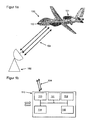
- FIGS. 1a and 1b show a first embodiment of an unmanned aerial vehicle 100 and a flight control system 110.
- FIG. 1a 1 shows an embodiment of an unmanned aerial vehicle 100 and a ground control station 102.
- the ground control station 102 is configured to control and / or monitor the aircraft 100.
- a plurality of communication links 104 are provided between the ground control station 102 and the aircraft 100 ,
- the unmanned aerial vehicle 100 has a buoyancy and propulsion system 101 and a flight control system 110.
- the flight control system 110 includes a flight control unit 111, a navigation system 112, a communication system 113, and an actuator system 114.
- the flight control system 110 is described in further detail in FIG FIG. 1b shown.
- the flight control unit 111 of the flight control system 110 is provided to calculate, based on data from the navigation system 112 and / or data from a ground control station 102 control commands that are supplied to the Aktuatoriksystem 114.
- the actuator system 114 uses the control commands to control the lift and propulsion system 101 of the aircraft 100.
- the flight control system 110 further has a monitoring unit 115.
- the monitoring unit 115 is set up to monitor the communication system 113. In this case, the monitoring unit 115 determines whether all communication links 104 of a plurality of communication links 104 between the aircraft 100 and the ground control station 102 are interrupted.
- the monitoring unit 115 is further provided, upon detection of an interruption of the communication 104 from the aircraft 100 to the ground control station 102, the To cause flight control unit 111 to safely land the aircraft 100 at a suitable landing site based on stored data on current flight conditions and nearby landing sites.
- FIG. 1b 1 shows an embodiment of a flight control system 110.
- the flight control system 110 has a flight control unit 111, a navigation system 112, a communication system 113, an actuation system 114 and a monitoring unit 115.
- the flight control unit 111, the navigation system 112, the communication system 113, the Aktuatoriksystem 114 and the monitoring unit 115 are interconnected by means of electrical lines or via a bus system (not shown).
- the flight control unit 111 is provided to calculate, based on data from the navigation system 112 and / or data from a ground control station 102 control commands, which are supplied to the Aktuatoriksystem 114.
- the actuation system 114 uses the control commands to control the lift and propulsion system 101 of the aircraft 100.
- the navigation system 112 receives, for example, GNSS data for determining the position of the aircraft 100.
- the aircraft 100 communicates with the ground control station 102 via a plurality of communication links 104 ,
- flight control system in the FIGS. 1a and 1b are shown only in a simple design, parts of the flight control system or the entire flight control system can also be redundant in the aircraft.
- a decision unit (not shown) may be present which, on the basis of the redundant results from the multiple units makes decisions according to predetermined rules.
- Such decision-making units are known in aviation.
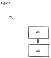
- FIG. 2 shows a flowchart 200 of an embodiment of a method for safely landing an unmanned aerial vehicle.
- step 201 of the method it is determined whether all communication links of a plurality of communication links between the aircraft and a ground control station, set up for controlling and / or monitoring the aircraft, are interrupted.
- step 202 upon detection of an interruption in the communication link between the aircraft and ground control station, the aircraft is landed at a suitable landing site based on stored data on current flight conditions and nearby landing sites.
- FIG. 3 1 shows a ground control station 300 for controlling and / or monitoring at least one unmanned aerial vehicle 301.
- the ground control station 300 has a communication system 310.
- the communication system 310 is configured to communicate with the unmanned aerial vehicle 301 and to communicate with an air traffic control 302.
- the communication at least between the ground control station 300 and the unmanned aerial vehicle 301 has a plurality of communication links 304.
- the ground control station 304 further comprises a monitoring device 311.
- the monitoring device 311 is set up to monitor the plurality of communication links 304 of the ground control station 300 with the aircraft 301 and Air Traffic Control 302. If the monitoring device 311 determines that all communication links 304 of the plurality of communication links 304 between the ground control station 300 and the aircraft 301 are disrupted, information about the current navigation data and the identification data of the aircraft 301 is transmitted to the air traffic control 302.
- FIG. 4 shows a sketch 400 of possible flight routes for the safe landing of an unmanned aerial vehicle 402 on a landing site 410.
- the unmanned aerial vehicle 402 determines an approach route 404, 405 corresponding to the locally prescribed traffic circle.
- the unmanned aerial vehicle air traffic control system will detect the corresponding landing threshold on the basis of the available geographic and meteorological information in case of failure of all communication links. For example, aircraft 402 north wind direction 403 selects a flight route 404 that causes the aircraft to land over two standard curves 406 at the correct approach angle on the landing threshold 411 of runway 410.
- the flight route 405 is selected, which allows the aircraft 402 to be placed on the opposite landing threshold 411 of the runway 410 via a standard curve 406.
- the location or time of failure of all communication links between the aircraft 402 and the ground control station may be at the in FIG. 4 illustrated embodiment, for example, when illustrated symbol for the aircraft 402 be done. If the failure occurs at a location or time when the aircraft 402 is farther from the appropriate next landing site, the aircraft becomes according to the planning of the flight route accordingly brought to the round of the landing field.
Landscapes
- Engineering & Computer Science (AREA)
- Aviation & Aerospace Engineering (AREA)
- Physics & Mathematics (AREA)
- General Physics & Mathematics (AREA)
- Radar, Positioning & Navigation (AREA)
- Remote Sensing (AREA)
- Automation & Control Theory (AREA)
- Traffic Control Systems (AREA)
Abstract
Description
- Verschiedene Ausführungsformen betreffen allgemein ein unbemanntes Luftfahrzeug, ein Verfahren zur sicheren Landung eines unbemannten Luftfahrzeugs und eine Bodenkontrollstation zur Steuerung und/oder Überwachung wenigstens eines unbemannten Luftfahrzeugs.
- Bei einem Datenlinkausfall ist ein unbemanntes Luftfahrzeug entweder teilweise oder gar nicht mehr ansprech- und kontrollierbar. Es befindet sich in diesem Flugzustand sozusagen in einem "autonomen" Modus, in dem es völlig auf sich allein gestellt ist. Bei bemannten Luftfahrzeugen sind automatische Landeverfahren bekannt, wonach ein Luftfahrzeugführer in den Landeanflug nicht mehr persönlich eingreifen muss, sobald er das automatische Anflugverfahren initiiert hat. Dabei verfügt der Luftfahrzeugführer in der Regel über eine existierende Sprechfunkverbindung zur Flugverkehrskontrolle und ist damit kooperativ. Ist die Sprechfunkverbindung hingegen ausgefallen, erscheint das Flugzeug in einer Kontrollzone trotzdem noch auf den Radarschirmen, der Pilot kann durch Sichtzeichen (Hin-undher-Wippen um die Rollachse) oder durch Lichtsignale an den Tower auf seine Lage aufmerksam machen. Ein bemanntes Flugzeug ist insoweit kooperativ, als es seine Absicht, eine Sicherheitslandung durchzuführen, kundtun kann und dadurch von den Fluglotsen Priorität eingeräumt bekommen kann. Ein unbemanntes Luftfahrzeug, das irgendwo auf seiner Mission einen irreversiblen Datenlinkausfall erfährt, zeigt aber lediglich indirekt an, dass es nicht mehr kommandiert werden kann, da es auf Kommandos nicht mehr reagiert, kann jedoch seine Absichten, wann und wo es zu landen gedenkt, der Flugverkehrskontrollstelle nicht mitteilen. Es verhält sich also klassisch nicht-kooperativ.
- Davon ausgehend ist es Aufgabe der Erfindung, ein verbessertes unbemanntes Luftfahrzeug anzugeben.
- Diese Aufgabe wird mit einer Vorrichtung mit den Merkmalen des Anspruchs 1 gelöst. Beispielhafte Ausführungsformen sind in den abhängigen Ansprüchen dargestellt. Es sei darauf hingewiesen, dass die Merkmale der Ausführungsbeispiele der Vorrichtungen auch für Ausführungsformen des Verfahrens gelten und umgekehrt.
- Es wird ein unbemanntes Luftfahrzeug angegeben, das ein Auftriebs- und Vortriebssystem sowie ein Flugkontrollsystem aufweist. Das Flugkontrollsystem weist eine Flugkontrolleinheit, ein Navigationssystem, ein Kommunikationssystem und ein Aktuatoriksystem auf. Die Flugkontrolleinheit ist vorgesehen, anhand von Daten aus dem Navigationssystem und/oder Daten von einer Bodenkontrollstation Steuerkommandos zu berechnen, die dem Aktuatoriksystem zuführbar sind zur Ansteuerung des Auftriebs- und Vortriebssystems. Die Bodenkontrollstation ist eingerichtet zur Steuerung und/oder Überwachung des Luftfahrzeugs. Weiter weist das Luftfahrzeug eine Überwachungseinheit auf. Die Überwachungseinheit ist eingerichtet zur Überwachung des Kommunikationssystems, zur Ermittlung, ob alle Kommunikationsverbindungen einer Mehrzahl von Kommunikationsverbindungen zwischen dem Luftfahrzeug und der Bodenkontrollstation unterbrochen sind. Die Überwachungseinheit ist weiter dafür vorgesehen, bei Ermittlung einer Unterbrechung der Kommunikation von dem Luftfahrzeug zu der Bodenkontrollstation, die Flugkontrolleinheit anhand von gespeicherten Daten über aktuelle Flugbedingungen und nahegelegene Landeplätze zu veranlassen, das Luftfahrzeug an einem geeigneten Landeplatz sicher zu landen.
- Als unbemanntes Luftfahrzeug kann auch ein klassisches bemanntes Luftfahrzeug verstanden werden, dass bei Ausfall der Luftfahrzeugführer wenigstens zweitweise "unbemannt" ist, bzw. ohne menschliche Kontrolle ist.
- Die Kommunikationsverbindung kann beispielsweise ein Command- und-Control-Datenlink zwischen dem unbemannten Luftfahrzeug (RPAS - Remotely Piloted Aircraft System) und der Bodenkontrollstation (RPAS Controller) sein.
- Der Erfindung liegt der Gedanke zugrunde, das ein unbemanntes Luftfahrzeug sicher zur Landung gebracht werden kann, indem das Luftfahrzeug bei Ausfall der Kommunikationsverbindung zu der das Luftfahrzeug kontrollierenden Bodenkontrollstation eigenständig auf Grundlage einer Reihe zur Verfügung stehenden Informationen eigenständig in der Lage ist, abhängig von den aktuellen Wind- und Wetterbedingungen, einen nahegelegenen geeigneten Landeplatz aus einer Liste von verfügbaren Landeplätzen auszuwählen und das Luftfahrzeug entsprechend den lokalen Vorgaben des ausgewählten Landeplatzes zu landen. Hierbei erfolgt die Auswahl des geeigneten Landeplatzes nach vorgegebenen Regeln, so dass eine zuständige Luftverkehrskontrolle den für die Landung zu durchquerenden Luftraum und den geeigneten Landeplatz sperrt. Dadurch, dass die Regeln, nach denen die Auswahl des geeigneten Landeplatzes durch das Luftfahrzeug erfolgt der Luftverkehrskontrolle bekannt sind, kommt die Luftverkehrskontrolle bei identischer Datengrundlage, die vorliegt, zu dem gleichen geeigneten Landeplatz und kann ohne Datenaustausch mit dem unbemannten Luftfahrzeug den entsprechenden Luftraum und Landeplatz für die Durchquerung bzw. Landung des unbemannten Luftfahrzeugs gezielt sperren. Somit liegt zwischen dem Flugzeughersteller des unbemannten Luftfahrzeugs bzw. dem Betreiber des unbemannten Luftfahrzeugs und den Flugsicherheitsbehörde ein vereinbartes kooperatives Landeverfahren im Fall einer irreversiblen Datenlinkunterbrechung vor.
- Durch das hierin beschriebene Luftfahrzeug sind im Falle eines irreversiblen Datenlinkausfalls ein schnellstmögliches Handeln und ein sofortiges Anfliegen eines Ausweichflugplatzes möglich. Bei einem irreversiblen Datenlinkausfall ist jede Minute von Bedeutung, die das Flugzeug länger in der Luft weilt, da seine Unberechenbarkeit erhöht wird und die für die Flugsicherheit verantwortlichen Behörden in desto größere Nöte gebracht werden können.
- Im Falle eines Datenlinkausfalls sind gesetzliche Vereinbarungen über das zu erwartende Flugverhalten zwischen dem Hersteller und dem Gesetzgeber vorab zu treffen, damit letzterem Überraschungen in Bezug auf die Verkehrssicherheit des Luftfahrzeugs erspart bleiben und die gesetzlich vereinbarte Kooperation zwischen dem Teilnehmer am Luftverkehr und den Regulierungsbehörden gewährleistet werden kann.
- Das hierin beschriebene Luftfahrzeug stellt ein kooperatives System im Hinblick auf eine mögliche Verkehrszulassung dar.
- Die Bezeichnung "nahegelegen" bezeichnet einen Umkreis um die aktuelle Position des Luftfahrzeugs, der mit den zur Verfügung stehenden Energieressourcen des Luftfahrzeugs noch erreichbar ist, vorzugsweise jedoch möglichst nahe liegt.
- Gemäß einer bevorzugten Ausführungsform weist das Navigationssystem einen Speicher auf. In dem Speicher sind wenigstens nahegelegene Landeplätze und die aktuellen Wind- und Wetterdaten der näheren Umgebung des Luftfahrzeugs und der nahegelegenen Landeplätzen gespeichert. Zur Aktualisierung des Navigationssystems und der gespeicherten Landeplätze kann beispielsweise vor Abflug des unbemannten Luftfahrzeugs beispielsweise ein Auszug aus einer vollständigen Datenbank mit verfügbaren Landeplätzen geladen werden oder die Daten können während des Fluges für wenigstens einen Teil des Flugabschnittes sukzessive über beispielsweise eine Kommunikationsverbindung mit der Bodenkontrollstation nachgeladen werden. Neben den eigentlichen geographischen Koordinaten des Landeplatzes können auch weitere Informationen zu dem Landeplatz, wie beispielsweise lokale Überflugverbotszonen, geographische Eckpunkte von Platzrunden, Landeschwellen, lokale Navigationshilfsobjekte oder weitere Daten enthalten. Eine Datenbank, in der Ausweichflugplätze mit genauen geographischen Angaben über Start- und Landeschwellen und geeignete Navigationshilfen im fliegenden Segment abgelegt sind.
- Dies hat den Vorteil, dass das unbemannte Luftfahrzeug zu jeder Zeit eine Liste der wenigstens nahegelegenen Landeplätze zur Verfügung hat. Ein weiterer Vorteil besteht darin, dass hierdurch ein sicheres Landen gegen den Wind möglich ist und ein sicheres Ausweichen bei signifikanten Wettererscheinungen ermöglicht wird.
- Die Bezeichnung "Speicher" bezieht sich hier im Wesentlichen auf eine beliebige Art von Speicher, der Daten empfangen und speichern kann. Der Speicher ist im Allgemeinen übereinstimmend mit Speicher, der z. B. von einem Computerprozessor oder in einem Computersystem eingesetzt werden kann. Insbesondere bezieht sich Speicher, per Definition hierin, auf eine beliebige Art von Speicher, auf den während des Betriebs des Computers, der den Speicher einsetzt, geschrieben und von dem gelesen werden kann. Der Speicher kann z. B. Direktzugriffsspeicher (Random Access Memory oder RAM) umfassen. Der RAM kann z. B. statischer RAM (SRAM) sein. Andere Speichertypen umfassen, ohne hierauf beschränkt zu sein, dynamischen Direktzugriffsspeicher (Dynamic Random Access Memory oder DRAM) und verschiedene Speicherbauformen, die auf Latches, Flip-Flops und anderen bistabilen Konstrukten (z. B. Memristoren) basieren.
- Gemäß einer bevorzugten Ausführungsform ist die Flugkontrolleinheit weiter dafür vorgesehen, anhand der abgespeicherten Wind- und Wetterdaten von nahegelegenen Landeplätzen bei einer zu erwartenden Ankunftszeit an dem Landeplatz, einen geeigneten Landeplatz auszuwählen. Die Auswahl des geeigneten Landeplatzes erfolgt nach festgelegten Regeln. Um die Auswahl des geeigneten Landeplatzes auch parallel durch eine Bodenkontrollstation durchführen zu können, sind die Regeln, nach denen das Luftfahrzeug einen geeigneten Landeplatz auswählt, zuvor festgelegt. Genauer gesagt sind die Auswahlkriterien, nach denen die Auswahl des geeigneten Landeplatzes erfolgt sowohl dem Luftfahrzeug als auch eine zuständige Luftverkehrskontrolle bekannt, so dass das Luftfahrzeug und die Luftverkehrskontrolle, in Abhängigkeit von beispielsweise der letzten Position des Luftfahrzeugs bei Abbruch der Kommunikationsverbindungen und in Abhängigkeit von beispielsweise den gegebenen Wetterbedingungen der nächstgelegenen Landeplätze, den identischen Landeplatz als geeigneten Landeplatz ermitteln. Dadurch ist die Luftverkehrskontrolle in der Lage, alle notwendigen Maßnahmen vor Ort, d. h. am ausgewählten Landeplatz, anzuweisen bzw. durchzuführen, so dass eine sichere Landung des Luftfahrzeugs ermöglicht werden kann. Hierzu kann es beispielsweise erforderlich sein, dass die Bodenkontrollstation den Luftraum an dem ausgewählten geeigneten Landeplatz bzw. die ausgewählte Landebahn für die Landung des Luftfahrzeugs wenigstens zweitweise sperrt.
- Es wird hierdurch eine im Wesentlichen autonome An-Bord-Routenplanung durchgeführt, die eine Landung unter meteorologisch ungünstigen (signifikanten) Wetterbedingungen verhindert und das Luftfahrzeug auf einen anderen Ausweichflugplatz umlenkt.
- Gemäß einer bevorzugten Ausführungsform ist die Flugkontrolleinheit weiter dafür vorgesehen, eine Flugroute zu dem ausgewählten Landeplatz zu ermitteln, wobei die Ermittlung der Flugroute nach festgelegten Regeln erfolgt. Vorzugsweise erfolgt die Auswahl bzw. Festlegung der Flugroute zu dem ausgewählten Landeplatz auf einem möglichst kurzen Weg, d. h. die Flugkontrolleinheit wird das Fluggerät möglichst auf den nächstgelegenen Landeplatz leiten, der in Abhängigkeit von den vor Ort vorherrschenden Wetterbedingungen für die Landung geeignet ist. Dies hat den Vorteil, dass die Ermittlung der Flugroute nach klaren Regeln erfolgt und die Flugkontrolle am Boden entsprechend diesen Regeln den Luftraum bzw. den Landeplatz für die Landung des Fluggeräts wenigstens zeitweise sperren kann.
- Die Bezeichnung "Regeln" bezieht sich hier im Wesentlichen auf Anweisungen, die von der Flugverkehrskontrolle und von der Flugkontrolleinheit angewendet werden und nach denen die Entscheidung für die Auswahl eines geeigneten Landeplatzes erfolgt. Beispielsweise können die Regeln darin bestehen, dass beispielsweise unter Ausnutzung der Daten einer Datenbank mit Informationen über beispielsweise in der momentanen Umgebung des Fluggeräts vorhandene gesperrte Gebiete und verfügbare Landeplätze und der zur Verfügung stehenden Wind- und Wetterdaten für den ausgewählten Landeplatz das Fluggerät beispielsweise ausgehend von der aktuellen Position auf direktem Weg zu der Platzrunde des ausgewählten Landeplatzes geführt wird.
- Entsprechend der Ermittlung der Flugroute, wird aufgrund der Windrichtung die geeignete Landeschwelle erkannt und während des Landeanfluges der entsprechende Vorhaltewinkel so bestimmt, dass daraus die erwartete Ankunftszeit am Landeplatz berechnet werden kann.
- Zu dem Zeitpunkt, bei dem die Überwachungseinheit einen irreversible Datenlinkausfall des Luftfahrzeugs zu der Bodenkontrollstation erkennt, werden die aktuellen Positions- und Geschwindigkeitsdaten abgespeichert und die kinematischen Bewegungsgrößen unter vorübergehender Beibehaltung des Kurses über Grund und der Fluggeschwindigkeit des Luftfahrzeugs werden vorzugsweise eingefroren.
- Damit das unbemannte Luftfahrzeug die Flugroute zu einem geeigneten Landeplatz ermitteln kann, führt das Luftfahrzeug beispielsweise für sein Missionsgebiet einen gültigen Datenbankauszug mit, in dem die nahegelegenen Ausweichflugplätze oder Landeplätze mit Angabe der geographischen Koordinaten des Flugfeldes, der Start- und Landeschwelle sowie von markanten Peilobjekten am oder um das Flugplatzgelände abgelegt sind.
- Das unbemannte Luftfahrzeug kann auf die für sein Missionsgebiet geltenden und in einem beispielsweise überschreibbaren Speicher gespeicherten aktuellen Wetterdaten, insbesondere die darin enthaltenen Flugplatzwetterdaten des Ausweichflugplatzes, zugreifen und daraus nebst signifikanten Wettererscheinungen insbesondere die am Landeplatz herrschende Windrichtung und Windstärke zum erwarteten Ankunftszeitpunkt entnehmen.
- Gemäß einer bevorzugten Ausführungsform erfolgt die Ermittlung der Flugroute mittels Koppelnavigation. Alternativ kann die Ermittlung der Flugroute auch mittels Dopplernavigation oder Trägheitsnavigation erfolgen. Bei der Koppelnavigation kann das unbemannte Luftfahrzeug ausgehend von der letzten bekannten Position aus die Navigation zu dem ausgewählten geeigneten Landeplatz durchführen. Dies hat den Vorteil, dass für kurze Zeiträume, in denen das Luftfahrzeug in der Regel gelandet sein sollte, eine möglichst genaue Navigation möglich ist.
- Die nach dem Luftrecht zu erwartende Reaktion des Luftfahrzeuges (kooperatives System), insbesondere die Wahl des geeigneten Ausweichflugplatzes, kann beispielsweise in einer rechtsverbindlichen Form zwischen dem Flugzeughersteller und der Flugsicherung vorher bekanntgemacht worden sein, damit die Flugverkehrskontrolle die Reaktionen des Flugzeuges ebenfalls kennt und sich darauf einstellen kann.
- Das unbemannte Luftfahrzeug hat demnach beispielsweise nach den zwischen dem Flugzeughersteller und der Deutschen Flugsicherung o.ä. rechtsverbindlich vereinbarten Verfahren beispielsweise in die Betriebsart "Koppelnavigation" überzugehen und die Flugroute anhand seiner zuletzt eingefrorenen Flugdaten selbständig (autonom) festlegen, womit auch die Flugverkehrskontrollstelle in den beabsichtigten Flugweg kooperativ eingebunden wird.
- Dies hat den Vorteil, dass die Reaktionen des unbemannten Luftfahrzeugs damit aufgrund bestimmter Vereinbarungen bzw. gesetzlicher Vorgaben eindeutig festgelegt sind und der Nachvollziehbarkeit offengelegt sind.
- Gemäß einer bevorzugten Ausführungsform ist die ermittelte Flugroute fortlaufend durch regelmäßige Kreuzpeilungen zu abgespeicherten lokalen Zielen korrigierbar. Die Kreuzpeilung erfolgt vorzugsweise durch trigonometrische Berechnung mit Hilfe der GPS-Positionen. Bei jeglicher Triangulation ist es von Vorteil, dass die Messung möglichst früh ausgeführt wird, um die Genauigkeit zu erhöhen. Für die Wahl geeigneter Peilziele ist dies vorzugsweise zu berücksichtigen. Die hat den Vorteil, dass durch aktives Nachkorrigieren der Navigationsgrößen Verfahrensfehler minimiert werden können.
- Die Ermittlung der momentanen Flughöhe über Grund des Luftfahrzeugs kann beispielsweise mittels eines Laser- oder Radarhöhenmesser erfolgen. Diese Höhendaten können der Flugkontrolleinheit bereitgestellt werden, um Höhenkorrekturen an das Auftriebs- und Vortriebssystem übermitteln zu können.
- Gemäß einer bevorzugten Ausführungsform erfolgen Richtungs- und/oder Kursänderungen durch festgelegte Standardkurven an den, durch eine Platzrunde am ausgewählten Landeplatz festgelegten Orten. Wenn das unbemannte Luftfahrzeug beispielsweise in die Platzrunde einfliegt, ist es von Vorteil, wenn das unbemannte Luftfahrzeug auf dem Peilstrahl "reitet" und nicht in einer sogenannten Hundekurve anfliegt. Der Peilstrahl ist eine Gerade durch zwei Eckpunkte der Platzrunde. Damit das unbemannte Luftfahrzeug auf den Peilstrahl kommt, ist es vorteilhaft, wenn die Kreuzpeilung im Azimut gegen Null konvergiert. Durch die automatische Flugregelung ist anschließend vorzugsweise noch der Cross track error zu minimieren. Vorzugsweise beim Blindanflug auf die Landebahn ist dies von Vorteil, um im windabhängigen Schräganflug ein zentrales Aufsetzen zu ermöglichen. Die Bodenkoordinaten der Landeschwelle sind vorzugsweise für die vertikale Sinkbewegung von Interesse. Sind die Bodenkoordinaten der Landeschwelle nicht bekannt, kann das unbemannte Luftfahrzeug landen, setzt unter Umständen beim Landen etwas härter auf.
- Zusätzlich zur azimutalen Kreuzpeilung ist noch die vertikale Deckungspeilung für die Ansteuerung und die Minimierung der seitlichen Abdrift durch Wind von Bedeutung. Der entferntere Eckpunkt der Platzrunde wird dabei über dem nahegelegeneren (rechnerisch) gepeilt. Durch Minimierung dieser Deckungspeilung gelangt das anfliegende UAV exakt in die angegebene Sollhöhe der Platzrunde und kann von dort aus den sicheren Sinkflug einleiten.
- Gemäß einer bevorzugten Ausführungsform ist die Flugkontrolleinheit weiter dafür vorgesehen, eine geeignete Landeschwelle der wenigstens zwei möglichen Landeschwellen des ausgewählten Landeplatzes zu ermitteln. Eine Landeschwelle, (englisch threshold, THR) kennzeichnet normalerweise den Beginn der Landebahn auf einem Flugplatz. Sie wird mit weißer Farbe als Querbalken markiert.
Dies hat den Vorteil, dass die Landung des unbemannten Flugzeugs in dem dafür vorgesehenen Bereich der Landebahn erfolgen kann und eine noch genügend lange Landebahn für das Ausrollen des Luftfahrzeugs bereitsteht. - Gemäß einer bevorzugten Ausführungsform weist das Flugkontrollsystem weiter eine Entfernungsmessungsvorrichtung auf. Die Entfernungsmessungsvorrichtung ist eingerichtet, im Landeanflug regelmäßig den Abstand zur Landebahn zu ermitteln, um die ermittelte Flugroute bei Abweichungen zu korrigieren. Die Entfernungsmessung kann beispielsweise anhand markanter Objekte im Bereich der Landebahn oder der unmittelbaren oder näheren Umgebung des Landeplatzes erfolgen. Derartige markante Objekte können beispielsweise anhand ihrer geographischen Koordinaten dem Navigationssystem des unbemannten Luftfahrzeugs bereitstehen. Die eigentliche Entfernungsmessung kann beispielsweise mittels eines Lasers oder dergleichen erfolgen. Dies hat den Vorteil, dass die Genauigkeit für die Landung des unbemannten Luftfahrzeugs erhöht werden kann.
- Gemäß einer bevorzugten Ausführungsform ist die Flugkontrolleinheit weiter dafür vorgesehen, das Fluggerät durch regelmäßige Kreuzpeilungen mittels GNSS (Global Navigation Satellite System) -Messungen zu abgespeicherten Objekten am ausgewählten Landeplatz sicher zu landen. Hierbei wird davon ausgegangen, dass das GNSS-System des Fluggeräts noch funktionsfähig ist. Vorzugsweise weist das Luftfahrzeug mehrfach redundante GNSS-Systeme auf, so dass selbst bei Ausfall eines GNSS-Systems ein bzw. sogar zwei Ersatz-GNSS-Systeme zur Verfügung stehen. Dies hat den Vorteil, dass die Genauigkeit für die Landung des unbemannten Luftfahrzeugs erhöht werden kann.
- Das Luftfahrzeug kann seine zu Beginn durch Koppelnavigation festgelegte Route durch regelmäßige Abstandmessungen zur Landebahn sowie Abweichungen zur Kurslinie durch Kreuzpeilungen zu bekannten und ebenfalls in der Datenbank abgelegten Zielen fortlaufend korrigieren, bis das präzise Aufsetzen auf der gewählten Landeschwelle erfolgt ist und das Luftfahrzeug sicher ausrollen kann.
Richtungs- und Kursänderungen können beispielsweise an den durch die Platzrunde vorgeschriebenen Orten erfolgen und in der Betriebsart "Koppelnavigation" beispielsweise fest vereinbarten Standardkurven folgen. - Gemäß einer bevorzugten Ausführungsform ist die Flugkontrolleinheit weiter dafür vorgesehen, das Luftfahrzeug nach erfolgter Landung auf dem ausgewählten Landeplatz anhand abgespeicherter Informationen über die örtlichen Begebenheiten an eine sichere Parkposition zu leiten. Vorzugsweise sind in dem Speicher, auf den die Flugkontrolleinheit des unbemannten Luftfahrzeugs Zugriff hat, Daten über örtliche Begebenheiten, wie beispielsweise die Start-/Landebahnen, Rollbahnen, Vorfeld und weitere luftseitige Einrichtungen des ausgewählten Landeplatzes abgespeichert. Anhand dieser Informationen kann das unbemannte Luftfahrzeug zu einem sicheren Abstellplatz rollen, soweit dies aus eigener Kraft möglich ist. Alternativ kann das unbemannte Luftfahrzeug mit externer Hilfe zu einem sicheren Stellplatz gebracht werden. Dies hat den Vorteil, dass der Landeplatz für den normalen Flugverkehr wieder freigegeben werden kann, sobald das unbemannte Luftfahrzeug einen sicheren Stellplatz erreicht hat, bzw. sobald es die Landebahn verlassen hat.
- Weiter wird ein Verfahren zur sicheren Landung eines unbemannten Luftfahrzeugs angegeben. Das Verfahren weist des Schritt des Ermittelns, ob alle Kommunikationsverbindungen einer Mehrzahl von Kommunikationsverbindungen zwischen dem Luftfahrzeug und einer Bodenkontrollstation, eingerichtet zur Steuerung und/oder Überwachung des Luftfahrzeugs, unterbrochen sind, auf. Weiter weist das Verfahren den Schritt, Landen des Luftfahrzeugs an einem geeigneten Landeplatz anhand von gespeicherten Daten über die aktuellen Flugbedingungen und nahegelegenen Landeplätze, bei Ermittlung einer Unterbrechung der Kommunikationsverbindung zwischen dem Luftfahrzeug und der Bodenkontrollstation, auf.
- Gemäß einer bevorzugten Ausführungsform weist das Verfahren weiter den Schritt auf, Ermitteln durch die Bodenkontrollstation, ob alle Kommunikationsverbindungen der Mehrzahl von Kommunikationsverbindungen zwischen dem Luftfahrzeug und der Bodenkontrollstation unterbrochen sind und Übermittlung der Information über die Unterbrechung an eine Luftverkehrskontrolle.
- Gemäß einer bevorzugten Ausführungsform sperrt die Luftverkehrskontrolle wenigstens einen Teil eines zur Verfügung stehenden Luftraums und einen geeigneten Landeplatz für eine sichere Landung des Luftfahrzeugs. Das Luftfahrzeug wählt entsprechend mit der Luftverkehrskontrolle festgelegten Regeln den identischen geeigneten Landeplatz zur Landung aus.
- Weiter wird eine Bodenkontrollstation zur Steuerung und/oder Überwachung wenigstens eines unbemannten Luftfahrzeugs angegeben. Die Bodenkontrollstation weist ein Kommunikationssystem, eingerichtet zur Kommunikation mit dem unbemannten Luftfahrzeug und zur Kommunikation mit einer Flugverkehrskontrolle, aufweisend eine Mehrzahl von Kommunikationsverbindungen, auf. Weiter weist die Bodenkontrollstation eine Überwachungseinrichtung, eingerichtet zur Überwachung der Mehrzahl von Kommunikationsverbindungen der Bodenkontrollstation mit dem Luftfahrzeug und der Flugverkehrskontrolle, auf. Falls die Überwachungseinrichtung feststellt, dass alle Kommunikationsverbindungen der Mehrzahl von Kommunikationsverbindungen zwischen der Bodenkontrollstation und dem Luftfahrzeug unterbrochen ist, werden Informationen über die Navigationsdaten und Kennungsdaten des Luftfahrzeugs der Flugverkehrskontrolle übermittelt.
- Die Kommunikationsverbindung zwischen der Bodenkontrollstation und der Flugverkehrskontrolle bzw. Flugverkehrskontrollstelle kann beispielsweise eine digitale Kommunikationsverbindung oder eine analoge Kommunikationsverbindung sein.
- Durch Übermittlung des Ausfalls der Kommunikationsverbindungen zu dem unbemannten Luftfahrzeug an die Flugverkehrskontrolle, kann somit beim Auftreten eines irreversiblen Datenlinkausfalls automatisch eine sofortige Vorwarnung über die Gefährdung anderer Verkehrsteilnehmer durch ein nicht-kooperatives Luftfahrzeug ausgelöst werden.
- Zum Zeitpunkt eines irreversiblen und vollständigen Datenlinkausfalls wird von der Bodenkontrollstation aus eine Botschaft an die Flugverkehrskontrolle geschickt, mit der der Datenlinkausfall erklärt wird und die letztgültigen Navigations- und Kennungsdaten übermittelt werden.
- Die Flugverkehrskontrollstelle kann daraufhin den Luftraum in der Kontrollzone für andere Luftfahrzeuge vorübergehend sperren und muss dem unbemannten Luftfahrzeug eine bevorzugte Landung einräumen.
- Nach dem Stand der aktuellen Vorgaben im Luftverkehr sollte das Einleiten des Landeanflugs eines unbemannten Luftfahrzeugs ohne Genehmigung durch die Flugverkehrskontrollstelle im Regelfall nicht autonom durchgeführt werden. Im Falle eines irreversiblen Datenlinkausfalls ist das hierin beschriebene Verfahren somit zumindest zum aktuellen Zeitpunkt entsprechend vorher mit der Flugverkehrskontrollstelle zu vereinbaren. Falls ein Ausfall der Kommunikationsverbindung (Datenlink) zu der Bodenstation erfolgt, nachdem beispielsweise ein Instrumentenlandesystem (ILS) bereits aktiviert worden ist, wenn also dem unbemannten Luftfahrzeug die Landegenehmigung bereits von der Flugverkehrskontrolle erteilt worden ist, ist das beschriebene System zunächst redundant, zumal es sich um eine vorgesehene Landung handelt, die nicht mehr abgebrochen werden braucht. Das in dieser Erfindung beschriebene Verfahren dient vorzugsweise der Landung auf Ausweichflugplätzen und Landebahnen, die kein ILS haben, sowie in den Fällen, in denen das ILS noch nicht aktiviert worden ist.
- Für den Fall, dass vom Datenlinkausfall, d.h. dem Ausfall aller Kommunikationsverbindungen zwischen dem unbemannten Luftfahrzeug und der Bodenstation, zwei oder mehrere Luftfahrzeuge gleichzeitig betroffen sind, ist sehr unwahrscheinlich. Gemäß dem hierin beschriebenen Verfahren würde die Sperrung des Luftraums unverzüglich nach Bestätigung des Datenlinkausfalls des ersten Flugzeugs erfolgt, welches ihn gemeldet hat, so dass das zweite UAV, das z. B. eine Sekunde später betroffen ist, nicht mehr oder jedenfalls nicht priorisiert auf diesem Flugplatz landen dürfte, ehe nicht das erste gelandet ist und die Sperrung wieder aufgehoben wurde. Das zweite unbemannte Luftfahrzeug könnte beispielsweise seine Landung verschieben, bis die Landebahn wieder freigeben wäre. Sofern der Datenlinkausfall nicht wirklich exakt gleichzeitig auftritt, würden zu diesem Zeitpunkt aber weitere unbemannte Luftfahrzeuge bereits die Meldung von der Luftraumsperrung erhalten haben. Dies könnte beispielsweise dadurch erfolgen, dass bei mehrfach redundanten Datenlinks bereits bei Ausfall der vorletzten Kommunikationsverbindung (in der Regel dürften nicht alle zu dem exakt gleichen Zeitpunkt ausfallen) oder noch früher Informationen bzgl. Sperrung und Landeerlaubnis ausgetauscht werden könnten, also dem Kollisionsgegner noch rechtzeitig zur Kenntnis gebracht werden könnten. Folglich könnte beispielsweise auf Positionsdaten des Kollisionsgegners durch Austausch von GPS-Daten stets zurückgegriffen werden und ein ausweichregelkonformes Verfahren angewandt werden. Ein mehrfach totaler Datenlinkausfall wäre folglich sehr unwahrscheinlich, und das Verhalten nach den vorher vereinbarten Regeln könnte beispielsweise die Verkehrssicherheit im Rahmen der Spezifikation der Ausfallshäufigkeit sicherstellen.
- In den Zeichnungen beziehen sich im Allgemeinen gleiche Bezugszeichen auf die gleichen Teile über die verschiedenen Ansichten hinweg. Die Zeichnungen sind nicht notwendigerweise maßstabsgetreu; Wert wird stattdessen im Allgemeinen auf die Veranschaulichung der Prinzipien der Erfindung gelegt. In der folgenden Beschreibung werden verschiedene Ausführungsformen der Erfindung beschrieben unter Bezugnahme auf die folgenden Zeichnungen, in denen:
- FIG. 1a
- und 1b eine erste Ausführungsform eines unbemannten Luftfahrzeugs und eines Flugkontrollsystems zeigen;
- FIG. 2
- ein Flussdiagramm einer Ausführungsform eines Verfahrens zur sicheren Landung eines unbemannten Luftfahrzeugs zeigt;
- FIG. 3
- eine Ausführungsform einer Bodenkontrollstation zur Steuerung und/oder Überwachung wenigstens eines unbemannten Luftfahrzeugs zeigt; und
- FIG. 4
- eine Skizze möglicher Flugrouten zur Landung eines unbemannten Luftfahrzeugs zeigt.
- Die folgende detaillierte Beschreibung nimmt Bezug auf die beigefügten Zeichnungen, welche zur Erläuterung spezifische Details und Ausführungsformen zeigen, in welchem die Erfindung praktiziert werden kann.
- Das Wort "beispielhaft" wird hierin verwendet mit der Bedeutung "als ein Beispiel, Fall oder Veranschaulichung dienend". Jede Ausführungsform oder Ausgestaltung, die hierin als "beispielhaft" beschrieben ist, ist nicht notwendigerweise als bevorzugt oder vorteilhaft gegenüber anderen Ausführungsformen oder Ausgestaltungen auszulegen.
- In der folgenden ausführlichen Beschreibung wird auf die beigefügten Zeichnungen Bezug genommen, die einen Teil dieser Beschreibung bilden und in denen zur Veranschaulichung spezifische Ausführungsformen gezeigt sind, in denen die Erfindung ausgeübt werden kann. In dieser Hinsicht wird Richtungsterminologie wie etwa "oben", "unten", "vorne", "hinten", "vorderes", "hinteres", usw. mit Bezug auf die Orientierung der beschriebenen Figur(en) verwendet. Da Komponenten von Ausführungsformen in einer Anzahl verschiedener Orientierungen positioniert werden können, dient die Richtungsterminologie zur Veranschaulichung und ist auf keinerlei Weise einschränkend. Es versteht sich, dass andere Ausführungsformen benutzt und strukturelle oder logische Änderungen vorgenommen werden können, ohne von dem Schutzumfang der vorliegenden Erfindung abzuweichen. Es versteht sich, dass die Merkmale der hierin beschriebenen verschiedenen beispielhaften Ausführungsformen miteinander kombiniert werden können, sofern nicht spezifisch anders angegeben. Die folgende ausführliche Beschreibung ist deshalb nicht in einschränkendem Sinne aufzufassen, und der Schutzumfang der vorliegenden Erfindung wird durch die angefügten Ansprüche definiert.
- Im Rahmen dieser Beschreibung werden die Begriffe "verbunden", "angeschlossen" sowie "gekoppelt" verwendet zum Beschreiben sowohl einer direkten als auch einer indirekten Verbindung, eines direkten oder indirekten Anschlusses sowie einer direkten oder indirekten Kopplung. In den Figuren werden identische oder ähnliche Elemente mit identischen Bezugszeichen versehen, soweit dies zweckmäßig ist.
- Bei den hier beschriebenen Verfahren können die Schritte in nahezu jeder beliebigen Reihenfolge ausgeführt werden, ohne von den Prinzipien der Erfindung abzuweichen, wenn nicht ausdrücklich eine zeitliche oder funktionale Abfolge aufgeführt ist. Wenn in einem Patentanspruch dargelegt wird, dass zuerst ein Schritt ausgeführt wird und dann mehrere andere Schritte nacheinander ausgeführt werden, so ist dies so zu verstehen, dass der erste Schritt vor allen anderen Schritten durchgeführt wird, die anderen Schritte jedoch in jeder beliebigen geeigneten Reihenfolge durchgeführt werden können, wenn nicht innerhalb der anderen Schritte eine Abfolge dargelegt ist. Teile von Ansprüchen, in denen beispielsweise "Schritt A, Schritt B, Schritt C, Schritt D und Schritt E" aufgeführt sind, sind so zu verstehen, dass Schritt A zuerst ausgeführt wird, Schritt E zuletzt ausgeführt wird und die Schritte B, C und D in jeder beliebigen Reihenfolge zwischen den Schritten A und E ausgeführt werden können, und dass die Abfolge in den formulierten Schutzumfang des beanspruchten Verfahrens fällt. Des Weiteren können angegebene Schritte gleichzeitig ausgeführt werden, wenn nicht eine ausdrückliche Formulierung im Anspruch darlegt, dass sie separat auszuführen sind. Beispielsweise können ein Schritt zum Ausführung von X im Anspruch und ein Schritt zum Ausführen von Y im Anspruch gleichzeitig innerhalb eines einzelnen Vorgangs durchgeführt werden, und der daraus resultierende Prozess fällt in den formulierten Schutzumfang des beanspruchten Verfahrens.
- Die
Figuren 1a und 1b zeigen eine erste Ausführungsform eines unbemanntes Luftfahrzeugs 100 und eines Flugkontrollsystems 110. -
Figur 1a zeigt eine Ausführungsform eines unbemannten Luftfahrzeugs 100 und eine Bodenkontrollstation 102. Die Bodenkontrollstation 102 ist eingerichtet zur Steuerung und/oder Überwachung des Luftfahrzeugs 100. Zur Steuerung und/oder Überwachung des Luftfahrzeugs 100 bestehen zwischen der Bodenkontrollstation 102 und dem Luftfahrzeug 100 eine Mehrzahl von Kommunikationsverbindungen 104. - Das unbemannte Luftfahrzeug 100 weist ein Auftriebs- und Vortriebssystem 101 und ein Flugkontrollsystem 110 auf. Das Flugkontrollsystem 110 weist eine Flugkontrolleinheit 111, ein Navigationssystem 112, ein Kommunikationssystem 113 und ein Aktuatoriksystem 114 auf. Das Flugkontrollsystem 110 ist im weiteren Detail in
Figur 1b dargestellt. - Die Flugkontrolleinheit 111 des Flugkontrollsystems 110 ist vorgesehen, anhand von Daten aus dem Navigationssystem 112 und/oder Daten von einer Bodenkontrollstation 102 Steuerkommandos zu berechnen, die dem Aktuatoriksystem 114 zugeführt werden. Das Aktuatoriksystem 114 verwendet die Steuerkommandos zur Ansteuerung des Auftriebs- und Vortriebssystems 101 des Luftfahrzeugs 100.
- Das Flugkontrollsystem 110 weist weiter eine Überwachungseinheit 115 auf. Die Überwachungseinheit 115 ist eingerichtet zur Überwachung des Kommunikationssystems 113. Hierbei ermittelt die Überwachungseinheit 115, ob alle Kommunikationsverbindungen 104 einer Mehrzahl von Kommunikationsverbindungen 104 zwischen dem Luftfahrzeug 100 und der Bodenkontrollstation 102 unterbrochen sind. Die Überwachungseinheit 115 ist weiter dafür vorgesehen, bei Ermittlung einer Unterbrechung der Kommunikation 104 von dem Luftfahrzeug 100 zu der Bodenkontrollstation 102, die Flugkontrolleinheit 111 anhand von gespeicherten Daten über aktuelle Flugbedingungen und nahegelegene Landeplätze zu veranlassen, das Luftfahrzeug 100 an einem geeigneten Landeplatz sicher zu landen.
-
Figur 1b zeigt eine Ausführungsform eines Flugkontrollsystems 110. Das Flugkontrollsystem 110 weist eine Flugkontrolleinheit 111, ein Navigationssystem 112, ein Kommunikationssystem 113, ein Aktuatoriksystem 114 und eine Überwachungseinheit 115 auf. Die Flugkontrolleinheit 111, das Navigationssystem 112, das Kommunikationssystem 113, das Aktuatoriksystem 114 und die Überwachungseinheit 115 sind miteinander mittels elektrischen Leitungen oder über ein Bussystem (nicht dargestellt) miteinander verbunden. Die Flugkontrolleinheit 111 ist vorgesehen, anhand von Daten aus dem Navigationssystem 112 und/oder Daten von einer Bodenkontrollstation 102 Steuerkommandos zu berechnen, die dem Aktuatoriksystem 114 zugeführt werden. Das Aktuatoriksystem 114 verwendet die Steuerkommandos zur Ansteuerung des Auftriebs- und Vortriebssystems 101 des Luftfahrzeugs 100. Das Navigationssystem 112 empfängt beispielsweise GNSS-Daten zur Positionsbestimmung des Luftfahrzeugs 100. Über das Kommunikationssystem 113 kommuniziert das Luftfahrzeug 100 über eine Mehrzahl von Kommunikationsverbindungen 104 mit der Bodenkontrollstation 102. - Obwohl das Flugkontrollsystem in den
Figuren 1a und 1b nur in einfacher Ausführung dargestellt sind, können Teile des Flugkontrollsystems oder das gesamte Flugkontrollsystem auch redundant in dem Luftfahrzeug vorhanden sein. Hierbei kann eine Entscheidungseinheit (nicht dargestellt) vorhanden sein, die anhand der redundant vorhandenen Ergebnisse aus den mehrfach vorhandenen Einheiten Entscheidungen nach vorgegebenen Regeln trifft. Derartige Entscheidungseinheiten sind in der Luftfahrt bekannt. -
Figur 2 zeigt ein Flussdiagramm 200 einer Ausführungsform eines Verfahrens zur sicheren Landung eines unbemannten Luftfahrzeugs. - In Schritt 201 des Verfahrens wird ermittelt, ob alle Kommunikationsverbindungen einer Mehrzahl von Kommunikationsverbindungen zwischen dem Luftfahrzeug und einer Bodenkontrollstation, eingerichtet zur Steuerung und/oder Überwachung des Luftfahrzeugs, unterbrochen sind. In Schritt 202 wird bei Ermittlung einer Unterbrechung der Kommunikationsverbindung zwischen dem Luftfahrzeug und der Bodenkontrollstation das Luftfahrzeug an einem geeigneten Landeplatz anhand von gespeicherten Daten über die aktuellen Flugbedingungen und nahegelegenen Landeplätze gelandet.
-
Figur 3 zeigt eine Bodenkontrollstation 300 zur Steuerung und/ oder Überwachung wenigstens eines unbemannten Luftfahrzeugs 301. Die Bodenkontrollstation 300 weist ein Kommunikationssystem 310 auf. Das Kommunikationssystem 310 ist eingerichtet zur Kommunikation mit dem unbemannten Luftfahrzeug 301 und zur Kommunikation mit einer Flugverkehrskontrolle 302. Hierzu weist die Kommunikation wenigstens zwischen der Bodenkontrollstation 300 und dem unbemannten Luftfahrzeug 301 eine Mehrzahl von Kommunikationsverbindungen 304 auf. Die Bodenkontrollstation 304 weist weiter eine Überwachungseinrichtung 311 auf. Die Überwachungseinrichtung 311 ist eingerichtet zur Überwachung der Mehrzahl von Kommunikationsverbindungen 304 der Bodenkontrollstation 300 mit dem Luftfahrzeug 301 und der Flugverkehrskontrolle 302. Falls die Überwachungseinrichtung 311 feststellt, dass alle Kommunikationsverbindungen 304 der Mehrzahl von Kommunikationsverbindungen 304 zwischen der Bodenkontrollstation 300 und dem Luftfahrzeug 301 unterbrochen sind, werden Informationen über die aktuellen Navigationsdaten und die Kennungsdaten des Luftfahrzeugs 301 der Flugverkehrskontrolle 302 übermittelt. -
Figur 4 zeigt eine Skizze 400 möglicher Flugrouten zur sicheren Landung eines unbemannten Luftfahrzeugs 402 auf einem Landeplatz 410. Abhängig von der Windrichtung 403 ermittelt das unbemannte Luftfahrzeug 402 eine Anflugroute 404, 405 entsprechenden der lokal vorgegebenen Platzrunde. Abhängig von der Windrichtung erkennt das Flugkontrollsystem des unbemannten Luftfahrzeugs bei Ausfall aller Kommunikationsverbindung anhand der bereitstehenden geografischen und meteorologischen Informationen die entsprechende Landeschwelle. Beispielsweise wählt das Luftfahrzeug 402 bei nördlicher Windrichtung 403 eine Flugroute 404, die das Luftfahrzeug über zwei Standardkurven 406 im korrekten Anflugwinkel auf der Landeschwelle 411 der Landebahn 410 aufsetzen lässt. Bei südlicher Windrichtung 403 wird beispielsweise die Flugroute 405 gewählt, die das Luftfahrzeug 402 über eine Standardkurve 406 an der gegenüberliegenden Landeschwelle 411 der Landebahn 410 aufsetzen lässt. Der Ort bzw. Zeitpunkt des Ausfalls aller Kommunikationsverbindungen zwischen dem Luftfahrzeug 402 und der Bodenkontrollstation (nicht dargestellt) kann bei der inFigur 4 dargestellten Ausführungsform beispielsweise bei dargestelltem Symbol für das Luftfahrzeug 402 erfolgt sein. Erfolgt der Ausfall an einem Ort bzw. zu einem Zeitpunkt zu dem das Luftfahrzeug 402 noch weiter entfernt ist von dem geeigneten nächsten Landeplatz, wird das Luftfahrzeug entsprechend der Planung der Flugroute entsprechend an die Platzrunde des Landeplatzes herangeführt. - Obwohl die Erfindung vor allem unter Bezugnahme auf bestimmte Ausführungsformen gezeigt und beschrieben worden ist, sollte von denjenigen, die mit dem Fachgebiet vertraut sind, verstanden werden, dass zahlreiche Änderungen bezüglich Ausgestaltung und Details daran vorgenommen werden können, ohne vom Wesen und Bereich der Erfindung, wie durch die angefügten Ansprüche definiert, abzuweichen. Der Bereich der Erfindung wird somit durch die angefügten Ansprüche bestimmt, und es ist daher beabsichtigt, dass sämtliche Änderungen, welche unter den Wortsinn oder den Äquivalenzbereich der Ansprüche fallen, umfasst werden.
-
- 100
- Unbemanntes Luftfahrzeug
- 101
- Auftriebs- und Vortriebssystem
- 102
- Bodenkontrollstation
- 110
- Flugkontrollsystem
- 111
- Flugkontrolleinheit
- 112
- Navigationssystem
- 113
- Kommunikationssystem
- 114
- Aktuatoriksystem
- 115
- Überwachungseinheit
- 116
- Speicher
- 200
- Verfahren
- 201-202
- Schritte des Verfahrens
- 300
- Bodenkontrollstation
- 301
- Luftfahrzeug
- 302
- Flugverkehrskontrolle
- 304
- Kommunikationsverbindung
- 310
- Kommunikationssystem
- 311
- Überwachungseinrichtung
Claims (15)
- Unbemanntes Luftfahrzeug (100), aufweisend ein Auftriebs- und Vortriebssystem (101); und
ein Flugkontrollsystem (110) mit:einer Flugkontrolleinheit (111);einem Navigationssystem (112);einem Kommunikationssystem (113); undeinem Aktuatoriksystem (114);wobei die Flugkontrolleinheit (111) vorgesehen ist, anhand von Daten aus dem Navigationssystem (112) und/oder Daten von einer Bodenkontrollstation (102), eingerichtet zur Steuerung und/oder Überwachung des Luftfahrzeugs (100), Steuerkommandos zu berechnen, die dem Aktuatoriksystem (114) zuführbar sind zur Ansteuerung des Auftriebs- und Vortriebssystems (101);
wobei eine Überwachungseinheit (115) vorgesehen ist, die eingerichtet ist zur Überwachung des Kommunikationssystems (113), zur Ermittlung, ob alle Kommunikationsverbindungen (104) einer Mehrzahl von Kommunikationsverbindungen (104) zwischen dem Luftfahrzeug (100) und der Bodenkontrollstation (102) unterbrochen sind; und
wobei die Überwachungseinheit (115) weiter dafür vorgesehen ist, bei Ermittlung einer Unterbrechung der Kommunikation (104) von dem Luftfahrzeug (100) zu der Bodenkontrollstation (102), die Flugkontrolleinheit (111) anhand von gespeicherten Daten über aktuelle Flugbedingungen und nahegelegene Landeplätze zu veranlassen, das Luftfahrzeug (100) an einem geeigneten Landeplatz sicher zu landen. - Unbemanntes Luftfahrzeug (100) nach Anspruch 1,
wobei das Navigationssystem (112) einen Speicher (116) aufweist, in dem wenigstens nahegelegene Landeplätze und die aktuellen Wind- und Wetterdaten der näheren Umgebung des Luftfahrzeugs (100) und der nahegelegenen Landeplätzen gespeichert sind. - Unbemanntes Luftfahrzeug (100) nach Anspruch 2,
wobei die Flugkontrolleinheit (111) weiter dafür vorgesehen ist, anhand der abgespeicherten Wind- und Wetterdaten von nahegelegenen Landeplätzen bei einer zu erwartenden Ankunftszeit an dem Landeplatz, einen geeigneten Landeplatz auszuwählen, wobei die Auswahl des geeigneten Landeplatzes nach festgelegten Regeln erfolgt. - Unbemanntes Luftfahrzeug (100) nach Anspruch 3,
wobei die Flugkontrolleinheit (111) weiter dafür vorgesehen ist, eine Flugroute zu dem ausgewählten Landeplatz zu ermitteln, wobei die Ermittlung der Flugroute nach festgelegten Regeln erfolgt. - Unbemanntes Luftfahrzeug (100) nach Anspruch 4,
wobei die Ermittlung der Flugroute mittels Koppelnavigation erfolgt. - Unbemanntes Luftfahrzeug (100) nach Anspruch 5,
wobei die ermittelte Flugroute fortlaufend durch regelmäßige Kreuzpeilungen zu abgespeicherten lokalen Zielen korrigierbar ist. - Unbemanntes Luftfahrzeug (100) nach Anspruch 5 oder 6,
wobei Richtungs- und/oder Kursänderungen durch festgelegte Standardkurven an den, durch eine Platzrunde am ausgewählten Landeplatz festgelegten Orten, erfolgen. - Unbemanntes Luftfahrzeug (100) nach einem der Ansprüche 3 bis 7,
wobei die Flugkontrolleinheit (111) weiter dafür vorgesehen ist, eine geeignete Landeschwelle der wenigstens zwei möglichen Landeschwellen des ausgewählten Landeplatzes zu ermitteln. - Unbemanntes Luftfahrzeug (100) nach einem der Ansprüche 3 bis 8,
wobei das Flugkontrollsystem (110) weiter eine Entfernungsmessungsvorrichtung (116) aufweist, die eingerichtet ist, im Landeanflug regelmäßig den Abstand zur Landebahn zu ermitteln, um die ermittelte Flugroute bei Abweichungen zu korrigieren. - Unbemanntes Luftfahrzeug (100) nach einem der Ansprüche 3 bis 9,
wobei die Flugkontrolleinheit (111) weiter dafür vorgesehen ist, das Luftfahrzeug durch regelmäßige Kreuzpeilungen mittels GNSS-Messungen zu abgespeicherten Objekten am ausgewählten Landeplatz sicher zu landen. - Unbemanntes Luftfahrzeug (100) nach einem der Ansprüche 3 bis 10,
wobei die Flugkontrolleinheit (111) weiter dafür vorgesehen ist, das Luftfahrzeug (100) nach erfolgter Landung auf dem ausgewählten Landeplatz anhand abgespeicherter Informationen über die örtlichen Begebenheiten an eine sichere Parkposition zu leiten. - Verfahren (200) zur sicheren Landung eines unbemannten Luftfahrzeugs, aufweisend die Schritte:Ermitteln, ob alle Kommunikationsverbindungen einer Mehrzahl von Kommunikationsverbindungen zwischen dem Luftfahrzeug und einer Bodenkontrollstation, eingerichtet zur Steuerung und/oder Überwachung des Luftfahrzeugs, unterbrochen sind (201); undLanden des Luftfahrzeugs an einem geeigneten Landeplatz anhand von gespeicherten Daten über die aktuellen Flugbedingungen und nahegelegenen Landeplätze, bei Ermittlung einer Unterbrechung der Kommunikationsverbindung zwischen dem Luftfahrzeug und der Bodenkontrollstation (202).
- Verfahren (200) nach Anspruch 12,
wobei das Verfahren weiter den Schritt aufweist:Ermitteln durch die Bodenkontrollstation, ob alle Kommunikationsverbindungen der Mehrzahl von Kommunikationsverbindungen zwischen dem Luftfahrzeug und der Bodenkontrollstation unterbrochen sind und Übermittlung der Information über die Unterbrechung an eine Luftverkehrskontrolle. - Verfahren (200) nach Anspruch 13,
wobei weiter die Luftverkehrskontrolle wenigstens einen Teil eines zur Verfügung stehenden Luftraums und einen geeigneten Landeplatz für eine sichere Landung des Luftfahrzeugs sperrt;
wobei das Luftfahrzeug entsprechend mit der Luftverkehrskontrolle festgelegten Regeln den identischen geeigneten Landeplatz zur Landung auswählt. - Bodenkontrollstation (300) zur Steuerung und/oder Überwachung wenigstens eines unbemannten Luftfahrzeugs (301), aufweisend:ein Kommunikationssystem (310), eingerichtet zur Kommunikation mit dem unbemannten Luftfahrzeug (301) und zur Kommunikation mit einer Flugverkehrskontrolle (302), aufweisend eine Mehrzahl von Kommunikationsverbindungen (304);eine Überwachungseinrichtung (311), eingerichtet zur Überwachung der Mehrzahl von Kommunikationsverbindungen (304) der Bodenkontrollstation (300) mit dem Luftfahrzeug (301) und der Flugverkehrskontrolle (302);wobei, falls die Überwachungseinrichtung (311) feststellt, dass alle Kommunikationsverbindungen (304) der Mehrzahl von Kommunikationsverbindungen (304) zwischen der Bodenkontrollstation (300) und dem Luftfahrzeug (301) unterbrochen sind, Informationen über die Navigationsdaten und Kennungsdaten des Luftfahrzeugs (301) der Flugverkehrskontrolle (302) übermittelt werden.
Applications Claiming Priority (1)
| Application Number | Priority Date | Filing Date | Title |
|---|---|---|---|
| DE102015012477.3A DE102015012477A1 (de) | 2015-09-29 | 2015-09-29 | Unbemanntes Luftfahrzeug und Verfahren zur sicheren Landung eines unbemannten Luftfahrzeugs |
Publications (2)
| Publication Number | Publication Date |
|---|---|
| EP3151080A1 true EP3151080A1 (de) | 2017-04-05 |
| EP3151080B1 EP3151080B1 (de) | 2021-03-24 |
Family
ID=56997289
Family Applications (1)
| Application Number | Title | Priority Date | Filing Date |
|---|---|---|---|
| EP16002043.4A Active EP3151080B1 (de) | 2015-09-29 | 2016-09-21 | Verfahren zur sicheren landung eines unbemannten luftfahrzeugs |
Country Status (5)
| Country | Link |
|---|---|
| US (1) | US10319246B2 (de) |
| EP (1) | EP3151080B1 (de) |
| DE (1) | DE102015012477A1 (de) |
| ES (1) | ES2869465T3 (de) |
| RU (1) | RU2712716C2 (de) |
Cited By (4)
| Publication number | Priority date | Publication date | Assignee | Title |
|---|---|---|---|---|
| CN108736933A (zh) * | 2018-04-27 | 2018-11-02 | 常熟市天然气有限公司 | 基于射频标签与无线中继远传技术的无人机巡线检测系统 |
| CN110941282A (zh) * | 2019-11-15 | 2020-03-31 | 西北工业大学 | 一种用于无人机着陆的控制方法、系统、设备及可读存储介质 |
| CN112184042A (zh) * | 2020-10-09 | 2021-01-05 | 中国民航大学 | 无人机失控或失去动力故障状态坠地伤人风险评估方法 |
| DE102019118483A1 (de) * | 2019-07-09 | 2021-01-14 | Dr. Ing. H.C. F. Porsche Aktiengesellschaft | Kraftfahrzeug, Luftfahrzeug und Verfahren zum Betreiben derselben |
Families Citing this family (24)
| Publication number | Priority date | Publication date | Assignee | Title |
|---|---|---|---|---|
| FR3038991B1 (fr) * | 2015-07-16 | 2018-08-17 | Safran Electronics & Defense | Procede d'assistance automatique a l'atterrissage d'un aeronef |
| WO2018178759A1 (en) * | 2017-03-31 | 2018-10-04 | Telefonaktiebolaget Lm Ericsson (Publ) | Enhanced flight plan for unmanned traffic aircraft systems |
| KR102269925B1 (ko) | 2017-03-31 | 2021-06-29 | 텔레호낙티에볼라게트 엘엠 에릭슨(피유비엘) | 무인 공중 운반체로부터 송신되는 라디오 프레임에서의 지오로케이션 정보를 브로드캐스팅하기 위한 방법, 장치, 및 컴퓨터 판독가능 저장 매체 |
| US11218840B2 (en) | 2017-03-31 | 2022-01-04 | Telefonaktiebolaget Lm Ericsson (Publ) | Methods and systems for using network location services in a unmanned aircraft systems traffic management framework |
| WO2018189576A1 (en) | 2017-04-14 | 2018-10-18 | Telefonaktiebolaget Lm Ericsson (Publ) | Optimal unmanned aerial vehicle flight route planning based on quality-of-service requirements for data, telemetry, and command and control requirements in 3gpp networks |
| EP3619832B1 (de) | 2017-05-05 | 2021-04-07 | Telefonaktiebolaget LM Ericsson (PUBL) | Verfahren und anordnungen zum benutzen der flugbahn eines unbemanntes luftfahrzeugs (uav) zum koordinieren einer kommunikationsübergabe in netzwerken des kooperation projekts der dritten generation (3gpp). |
| EP3652985B1 (de) | 2017-07-10 | 2020-11-18 | Telefonaktiebolaget LM Ericsson (publ) | Optimierung der funkressourcenzuteilung auf der grundlage von flugbahninformationen unbemannter luftfahrzeuge |
| EP3679741A1 (de) | 2017-09-05 | 2020-07-15 | Telefonaktiebolaget LM Ericsson (PUBL) | Geplante kontinuität der verbindungskonnektivität eines unbemannten luftfahrzeugs (uav) in uav-verkehrsmanagementsystemen |
| CN107651190A (zh) * | 2017-10-17 | 2018-02-02 | 佛山市神风航空科技有限公司 | 一种校园无人机送外卖的方式及装置 |
| WO2019130050A1 (en) | 2017-12-29 | 2019-07-04 | Telefonaktiebolaget Lm Ericsson (Publ) | Using a cellular interface for unmanned aerial vehicle communications |
| WO2019186245A1 (en) | 2018-03-30 | 2019-10-03 | Telefonaktiebolaget Lm Ericsson (Publ) | Network coverage and policy information generation and distribution for unmanned aerial vehicle flight planning |
| DK201870684A1 (en) | 2018-08-27 | 2020-05-19 | Aptiv Technologies Limited | PARTITIONED WIRELESS COMMUNICATION SYSTEM WITH REDUNDANT DATA LINKS AND POWER LINES |
| US20200349852A1 (en) * | 2019-05-03 | 2020-11-05 | Michele DiCosola | Smart drone rooftop and ground airport system |
| RU2727416C1 (ru) * | 2019-08-26 | 2020-07-21 | Российская Федерация, от имени которой выступает Министерство обороны Российской Федерации | Способ управления полетом беспилотного летательного аппарата и беспилотная авиационная система |
| WO2021096565A1 (en) | 2019-11-15 | 2021-05-20 | Thales USA, Inc. | End-to-end unmanned control system of aircraft navigation and surveillance systems |
| US12020583B2 (en) | 2020-03-10 | 2024-06-25 | Honeywell International Inc. | Systems and methods providing assist-to-land and emergency land functions |
| RU2734171C1 (ru) * | 2020-04-29 | 2020-10-13 | Акционерное общество "Уральское производственное предприятие "Вектор" (АО "УПП "Вектор") | Способ оптимальной адаптации маршрута перехвата воздушной цели при нахождении в районе полетов группировки зенитных ракетных комплексов |
| EP3916698A1 (de) * | 2020-05-29 | 2021-12-01 | Volocopter GmbH | System und verfahren zur verwaltung des flugzeugbetriebs |
| US12387607B2 (en) * | 2020-12-10 | 2025-08-12 | Joby Aero, Inc. | Unmanned aircraft control using ground control station |
| CN113299121B (zh) * | 2021-04-06 | 2023-01-24 | 中电科芜湖通用航空产业技术研究院有限公司 | 一种可选有人或无人驾驶飞机的地面站系统 |
| US12112649B2 (en) | 2021-06-22 | 2024-10-08 | Honeywell International Inc. | Automatic autoland activation methods and systems |
| CN113716013B (zh) * | 2021-10-08 | 2024-03-15 | 湖南航天环宇通信科技股份有限公司 | 一种用于无人机气囊加压开盖的可抛弃式口盖及其无人机 |
| CN115776722B (zh) * | 2022-11-17 | 2026-03-17 | 亿航智能设备有限公司 | 多数据链路定位方法、系统、设备及计算机可读存储介质 |
| WO2025191596A1 (en) * | 2024-03-12 | 2025-09-18 | Tvs Motor Company Limited | A system and method for assisting landing of an unmanned aerial vehicle |
Citations (4)
| Publication number | Priority date | Publication date | Assignee | Title |
|---|---|---|---|---|
| US6377875B1 (en) * | 1998-10-29 | 2002-04-23 | Daimlerchrysler Ag | Method for remote-controlling an unmanned aerial vehicle |
| EP1657611A1 (de) * | 2004-11-16 | 2006-05-17 | Northrop Grumman Corporation | Verfahren und Vorrichtung zur automatischen Rountenbestimmung |
| US20070129855A1 (en) * | 2005-12-07 | 2007-06-07 | Thales | Device and method of automated construction of emergency flight path for aircraft |
| EP2853974A1 (de) * | 2013-09-26 | 2015-04-01 | Airbus Defence and Space GmbH | Verfahren zur autonomen Steuerung eines ferngesteuerten Fluggeräts und entsprechendes System |
Family Cites Families (14)
| Publication number | Priority date | Publication date | Assignee | Title |
|---|---|---|---|---|
| SE0300871D0 (sv) * | 2003-03-27 | 2003-03-27 | Saab Ab | Waypoint navigation |
| US7343232B2 (en) * | 2003-06-20 | 2008-03-11 | Geneva Aerospace | Vehicle control system including related methods and components |
| US7689328B2 (en) | 2006-12-21 | 2010-03-30 | Boeing Company | Determining suitable areas for off-airport landings |
| JP4253676B2 (ja) | 2006-12-22 | 2009-04-15 | トヨタ自動車株式会社 | 油面レベルセンサ異常検出装置 |
| IL218327A (en) * | 2012-02-26 | 2013-05-30 | Elbit Systems Ltd | Safe emergency landing of unmanned aerial vehicles |
| RU2523613C2 (ru) * | 2012-09-10 | 2014-07-20 | Лернер Илья Израйлевич | Способ дистанционного управления полетом беспилотного летательного аппарата и беспилотная авиационная система |
| US8798922B2 (en) * | 2012-11-16 | 2014-08-05 | The Boeing Company | Determination of flight path for unmanned aircraft in event of in-flight contingency |
| EP2733560A1 (de) * | 2012-11-19 | 2014-05-21 | The Boeing Company | Autonome Missionsverwaltung |
| US20160140851A1 (en) * | 2014-11-18 | 2016-05-19 | Ziv LEVY | Systems and methods for drone navigation |
| US9645582B2 (en) * | 2015-06-25 | 2017-05-09 | Bell Helicopter Textron Inc. | Landing aircrafts with optimal landing spot selection |
| US10586464B2 (en) * | 2015-07-29 | 2020-03-10 | Warren F. LeBlanc | Unmanned aerial vehicles |
| US10762795B2 (en) * | 2016-02-08 | 2020-09-01 | Skydio, Inc. | Unmanned aerial vehicle privacy controls |
| US20170300065A1 (en) * | 2016-04-18 | 2017-10-19 | Latitude Engineering, LLC | Automatic recovery systems and methods for unmanned aircraft systems |
| US10109205B2 (en) * | 2016-06-10 | 2018-10-23 | ETAK Systems, LLC | Air traffic control monitoring systems and methods for unmanned aerial vehicles |
-
2015
- 2015-09-29 DE DE102015012477.3A patent/DE102015012477A1/de not_active Ceased
-
2016
- 2016-09-21 ES ES16002043T patent/ES2869465T3/es active Active
- 2016-09-21 EP EP16002043.4A patent/EP3151080B1/de active Active
- 2016-09-28 RU RU2016138408A patent/RU2712716C2/ru active
- 2016-09-29 US US15/280,436 patent/US10319246B2/en active Active
Patent Citations (4)
| Publication number | Priority date | Publication date | Assignee | Title |
|---|---|---|---|---|
| US6377875B1 (en) * | 1998-10-29 | 2002-04-23 | Daimlerchrysler Ag | Method for remote-controlling an unmanned aerial vehicle |
| EP1657611A1 (de) * | 2004-11-16 | 2006-05-17 | Northrop Grumman Corporation | Verfahren und Vorrichtung zur automatischen Rountenbestimmung |
| US20070129855A1 (en) * | 2005-12-07 | 2007-06-07 | Thales | Device and method of automated construction of emergency flight path for aircraft |
| EP2853974A1 (de) * | 2013-09-26 | 2015-04-01 | Airbus Defence and Space GmbH | Verfahren zur autonomen Steuerung eines ferngesteuerten Fluggeräts und entsprechendes System |
Cited By (6)
| Publication number | Priority date | Publication date | Assignee | Title |
|---|---|---|---|---|
| CN108736933A (zh) * | 2018-04-27 | 2018-11-02 | 常熟市天然气有限公司 | 基于射频标签与无线中继远传技术的无人机巡线检测系统 |
| CN108736933B (zh) * | 2018-04-27 | 2021-06-22 | 常熟市天然气有限公司 | 基于射频标签与无线中继远传技术的无人机巡线检测系统 |
| DE102019118483A1 (de) * | 2019-07-09 | 2021-01-14 | Dr. Ing. H.C. F. Porsche Aktiengesellschaft | Kraftfahrzeug, Luftfahrzeug und Verfahren zum Betreiben derselben |
| CN110941282A (zh) * | 2019-11-15 | 2020-03-31 | 西北工业大学 | 一种用于无人机着陆的控制方法、系统、设备及可读存储介质 |
| CN112184042A (zh) * | 2020-10-09 | 2021-01-05 | 中国民航大学 | 无人机失控或失去动力故障状态坠地伤人风险评估方法 |
| CN112184042B (zh) * | 2020-10-09 | 2022-05-13 | 中国民航大学 | 无人机失控或失去动力故障状态坠地伤人风险评估方法 |
Also Published As
| Publication number | Publication date |
|---|---|
| EP3151080B1 (de) | 2021-03-24 |
| RU2712716C2 (ru) | 2020-01-30 |
| RU2016138408A3 (de) | 2019-12-20 |
| US10319246B2 (en) | 2019-06-11 |
| ES2869465T3 (es) | 2021-10-25 |
| DE102015012477A1 (de) | 2017-03-30 |
| US20170092137A1 (en) | 2017-03-30 |
| RU2016138408A (ru) | 2018-04-02 |
Similar Documents
| Publication | Publication Date | Title |
|---|---|---|
| EP3151080B1 (de) | Verfahren zur sicheren landung eines unbemannten luftfahrzeugs | |
| US12387607B2 (en) | Unmanned aircraft control using ground control station | |
| AU2018317851B2 (en) | An unmanned aerial vehicle system for inspecting railroad assets | |
| DE69512835T2 (de) | Gerät zur Vermeidung von Flugzeugkollisionen insbesondere mit dem Boden, mit reduzierter Energiebilanz | |
| US20220005363A1 (en) | Flight assistant | |
| DE69910836T2 (de) | Verfahren und gerät zur automatischen selektierung von landebahnen | |
| DE69307377T2 (de) | Verfahren und Vorrichtung zur Grundkollisionsvermeidung für Flugzeuge | |
| EP1653250B1 (de) | Integriertes system für flugzeug-wirbelsicherheit | |
| DE69935161T2 (de) | System und verfahren zur kollisionsvermeidung mittels einer positionsverhaltung für einen nahen/inneren verband | |
| DE69308479T2 (de) | Gerät zur Vermeidung von Flugzeugkollisionen, insbesondere mit dem Bodem | |
| DE69517725T2 (de) | Gerät zur Vermeidung von Flugzeugkollisionen, insbesondere mit dem Boden durch Anflugneigungskontrolle | |
| DE69915039T2 (de) | Verfahren zur rekonfigurierung in echtzeit der flugbahnen eines flugzeuges | |
| DE60101781T2 (de) | System zur flugsteuerung eines kreismanövers zum landen | |
| DE60106435T2 (de) | Verfahren zur berechnung einer ausweichflugbahn für ein flugzeug in der horizontalen ebene zur auflösung eines flugverkehrskonflikts | |
| RU2692306C2 (ru) | Система сопровождения для беспилотных авиационных транспортных средств | |
| DE60030413T2 (de) | Verfahren, Vorrichtung und Computerprogrammprodukte zum Bestimmen einer korrigierten Entfernung zwischen einem Flugzeug und einer gewählten Landebahn | |
| US7937191B2 (en) | Termination secured route planning | |
| DE60121200T2 (de) | Verfahren zur führung eines flugzeugs in einer formation | |
| EP3762913B1 (de) | Luftlageinformations- und verkehrsmanagementsystem für unbemannte und bemannte luftfahrzeuge | |
| DE69915773T2 (de) | Begrenzungsverfahren für automatisches Steuern der Rollage mittels Schubänderung | |
| DE602004002257T2 (de) | Flugführungsverfahren eines Luftfahreugs in der Landeanflugphase und zugehörige Bodenstation | |
| EP3648081A1 (de) | Verfahren zum betrieb eines zumindest zeitweise unbemannten luftfahrzeugs sowie ein derartiges luftfahrzeug | |
| EP1495457B1 (de) | Sicherheittssystem fur luftfahrzeuge | |
| DE69903169T2 (de) | Vorrichtung bestimmt zur verbesserung der sicherheit von flugzeugen während des sichtfluges | |
| DE102020112415A1 (de) | Zonenbasierte landesysteme und -verfahren für unbemannte luftfahrzeuge |
Legal Events
| Date | Code | Title | Description |
|---|---|---|---|
| PUAI | Public reference made under article 153(3) epc to a published international application that has entered the european phase |
Free format text: ORIGINAL CODE: 0009012 |
|
| STAA | Information on the status of an ep patent application or granted ep patent |
Free format text: STATUS: THE APPLICATION HAS BEEN PUBLISHED |
|
| AK | Designated contracting states |
Kind code of ref document: A1 Designated state(s): AL AT BE BG CH CY CZ DE DK EE ES FI FR GB GR HR HU IE IS IT LI LT LU LV MC MK MT NL NO PL PT RO RS SE SI SK SM TR |
|
| AX | Request for extension of the european patent |
Extension state: BA ME |
|
| STAA | Information on the status of an ep patent application or granted ep patent |
Free format text: STATUS: REQUEST FOR EXAMINATION WAS MADE |
|
| 17P | Request for examination filed |
Effective date: 20170926 |
|
| RBV | Designated contracting states (corrected) |
Designated state(s): AL AT BE BG CH CY CZ DE DK EE ES FI FR GB GR HR HU IE IS IT LI LT LU LV MC MK MT NL NO PL PT RO RS SE SI SK SM TR |
|
| STAA | Information on the status of an ep patent application or granted ep patent |
Free format text: STATUS: EXAMINATION IS IN PROGRESS |
|
| 17Q | First examination report despatched |
Effective date: 20180125 |
|
| GRAP | Despatch of communication of intention to grant a patent |
Free format text: ORIGINAL CODE: EPIDOSNIGR1 |
|
| STAA | Information on the status of an ep patent application or granted ep patent |
Free format text: STATUS: GRANT OF PATENT IS INTENDED |
|
| RIC1 | Information provided on ipc code assigned before grant |
Ipc: G08G 5/00 20060101ALI20200918BHEP Ipc: G05D 1/00 20060101AFI20200918BHEP Ipc: G08G 5/02 20060101ALI20200918BHEP Ipc: G05D 1/06 20060101ALI20200918BHEP Ipc: B64C 39/02 20060101ALI20200918BHEP Ipc: G08G 5/06 20060101ALI20200918BHEP |
|
| INTG | Intention to grant announced |
Effective date: 20201007 |
|
| GRAS | Grant fee paid |
Free format text: ORIGINAL CODE: EPIDOSNIGR3 |
|
| GRAA | (expected) grant |
Free format text: ORIGINAL CODE: 0009210 |
|
| STAA | Information on the status of an ep patent application or granted ep patent |
Free format text: STATUS: THE PATENT HAS BEEN GRANTED |
|
| AK | Designated contracting states |
Kind code of ref document: B1 Designated state(s): AL AT BE BG CH CY CZ DE DK EE ES FI FR GB GR HR HU IE IS IT LI LT LU LV MC MK MT NL NO PL PT RO RS SE SI SK SM TR |
|
| REG | Reference to a national code |
Ref country code: GB Ref legal event code: FG4D Free format text: NOT ENGLISH |
|
| REG | Reference to a national code |
Ref country code: CH Ref legal event code: EP |
|
| REG | Reference to a national code |
Ref country code: IE Ref legal event code: FG4D Free format text: LANGUAGE OF EP DOCUMENT: GERMAN |
|
| REG | Reference to a national code |
Ref country code: AT Ref legal event code: REF Ref document number: 1375117 Country of ref document: AT Kind code of ref document: T Effective date: 20210415 Ref country code: DE Ref legal event code: R096 Ref document number: 502016012638 Country of ref document: DE |
|
| REG | Reference to a national code |
Ref country code: LT Ref legal event code: MG9D |
|
| PG25 | Lapsed in a contracting state [announced via postgrant information from national office to epo] |
Ref country code: NO Free format text: LAPSE BECAUSE OF FAILURE TO SUBMIT A TRANSLATION OF THE DESCRIPTION OR TO PAY THE FEE WITHIN THE PRESCRIBED TIME-LIMIT Effective date: 20210624 Ref country code: BG Free format text: LAPSE BECAUSE OF FAILURE TO SUBMIT A TRANSLATION OF THE DESCRIPTION OR TO PAY THE FEE WITHIN THE PRESCRIBED TIME-LIMIT Effective date: 20210624 Ref country code: GR Free format text: LAPSE BECAUSE OF FAILURE TO SUBMIT A TRANSLATION OF THE DESCRIPTION OR TO PAY THE FEE WITHIN THE PRESCRIBED TIME-LIMIT Effective date: 20210625 Ref country code: HR Free format text: LAPSE BECAUSE OF FAILURE TO SUBMIT A TRANSLATION OF THE DESCRIPTION OR TO PAY THE FEE WITHIN THE PRESCRIBED TIME-LIMIT Effective date: 20210324 Ref country code: FI Free format text: LAPSE BECAUSE OF FAILURE TO SUBMIT A TRANSLATION OF THE DESCRIPTION OR TO PAY THE FEE WITHIN THE PRESCRIBED TIME-LIMIT Effective date: 20210324 |
|
| PG25 | Lapsed in a contracting state [announced via postgrant information from national office to epo] |
Ref country code: LV Free format text: LAPSE BECAUSE OF FAILURE TO SUBMIT A TRANSLATION OF THE DESCRIPTION OR TO PAY THE FEE WITHIN THE PRESCRIBED TIME-LIMIT Effective date: 20210324 Ref country code: RS Free format text: LAPSE BECAUSE OF FAILURE TO SUBMIT A TRANSLATION OF THE DESCRIPTION OR TO PAY THE FEE WITHIN THE PRESCRIBED TIME-LIMIT Effective date: 20210324 Ref country code: SE Free format text: LAPSE BECAUSE OF FAILURE TO SUBMIT A TRANSLATION OF THE DESCRIPTION OR TO PAY THE FEE WITHIN THE PRESCRIBED TIME-LIMIT Effective date: 20210324 |
|
| REG | Reference to a national code |
Ref country code: NL Ref legal event code: MP Effective date: 20210324 |
|
| PG25 | Lapsed in a contracting state [announced via postgrant information from national office to epo] |
Ref country code: NL Free format text: LAPSE BECAUSE OF FAILURE TO SUBMIT A TRANSLATION OF THE DESCRIPTION OR TO PAY THE FEE WITHIN THE PRESCRIBED TIME-LIMIT Effective date: 20210324 |
|
| REG | Reference to a national code |
Ref country code: ES Ref legal event code: FG2A Ref document number: 2869465 Country of ref document: ES Kind code of ref document: T3 Effective date: 20211025 |
|
| PG25 | Lapsed in a contracting state [announced via postgrant information from national office to epo] |
Ref country code: SM Free format text: LAPSE BECAUSE OF FAILURE TO SUBMIT A TRANSLATION OF THE DESCRIPTION OR TO PAY THE FEE WITHIN THE PRESCRIBED TIME-LIMIT Effective date: 20210324 Ref country code: LT Free format text: LAPSE BECAUSE OF FAILURE TO SUBMIT A TRANSLATION OF THE DESCRIPTION OR TO PAY THE FEE WITHIN THE PRESCRIBED TIME-LIMIT Effective date: 20210324 Ref country code: CZ Free format text: LAPSE BECAUSE OF FAILURE TO SUBMIT A TRANSLATION OF THE DESCRIPTION OR TO PAY THE FEE WITHIN THE PRESCRIBED TIME-LIMIT Effective date: 20210324 Ref country code: EE Free format text: LAPSE BECAUSE OF FAILURE TO SUBMIT A TRANSLATION OF THE DESCRIPTION OR TO PAY THE FEE WITHIN THE PRESCRIBED TIME-LIMIT Effective date: 20210324 |
|
| PG25 | Lapsed in a contracting state [announced via postgrant information from national office to epo] |
Ref country code: PT Free format text: LAPSE BECAUSE OF FAILURE TO SUBMIT A TRANSLATION OF THE DESCRIPTION OR TO PAY THE FEE WITHIN THE PRESCRIBED TIME-LIMIT Effective date: 20210726 Ref country code: PL Free format text: LAPSE BECAUSE OF FAILURE TO SUBMIT A TRANSLATION OF THE DESCRIPTION OR TO PAY THE FEE WITHIN THE PRESCRIBED TIME-LIMIT Effective date: 20210324 Ref country code: SK Free format text: LAPSE BECAUSE OF FAILURE TO SUBMIT A TRANSLATION OF THE DESCRIPTION OR TO PAY THE FEE WITHIN THE PRESCRIBED TIME-LIMIT Effective date: 20210324 Ref country code: RO Free format text: LAPSE BECAUSE OF FAILURE TO SUBMIT A TRANSLATION OF THE DESCRIPTION OR TO PAY THE FEE WITHIN THE PRESCRIBED TIME-LIMIT Effective date: 20210324 Ref country code: IS Free format text: LAPSE BECAUSE OF FAILURE TO SUBMIT A TRANSLATION OF THE DESCRIPTION OR TO PAY THE FEE WITHIN THE PRESCRIBED TIME-LIMIT Effective date: 20210724 |
|
| REG | Reference to a national code |
Ref country code: DE Ref legal event code: R097 Ref document number: 502016012638 Country of ref document: DE |
|
| PG25 | Lapsed in a contracting state [announced via postgrant information from national office to epo] |
Ref country code: DK Free format text: LAPSE BECAUSE OF FAILURE TO SUBMIT A TRANSLATION OF THE DESCRIPTION OR TO PAY THE FEE WITHIN THE PRESCRIBED TIME-LIMIT Effective date: 20210324 Ref country code: AL Free format text: LAPSE BECAUSE OF FAILURE TO SUBMIT A TRANSLATION OF THE DESCRIPTION OR TO PAY THE FEE WITHIN THE PRESCRIBED TIME-LIMIT Effective date: 20210324 |
|
| PLBE | No opposition filed within time limit |
Free format text: ORIGINAL CODE: 0009261 |
|
| STAA | Information on the status of an ep patent application or granted ep patent |
Free format text: STATUS: NO OPPOSITION FILED WITHIN TIME LIMIT |
|
| PG25 | Lapsed in a contracting state [announced via postgrant information from national office to epo] |
Ref country code: SI Free format text: LAPSE BECAUSE OF FAILURE TO SUBMIT A TRANSLATION OF THE DESCRIPTION OR TO PAY THE FEE WITHIN THE PRESCRIBED TIME-LIMIT Effective date: 20210324 |
|
| 26N | No opposition filed |
Effective date: 20220104 |
|
| REG | Reference to a national code |
Ref country code: CH Ref legal event code: PL |
|
| REG | Reference to a national code |
Ref country code: BE Ref legal event code: MM Effective date: 20210930 |
|
| PG25 | Lapsed in a contracting state [announced via postgrant information from national office to epo] |
Ref country code: IS Free format text: LAPSE BECAUSE OF FAILURE TO SUBMIT A TRANSLATION OF THE DESCRIPTION OR TO PAY THE FEE WITHIN THE PRESCRIBED TIME-LIMIT Effective date: 20210724 Ref country code: MC Free format text: LAPSE BECAUSE OF FAILURE TO SUBMIT A TRANSLATION OF THE DESCRIPTION OR TO PAY THE FEE WITHIN THE PRESCRIBED TIME-LIMIT Effective date: 20210324 |
|
| PG25 | Lapsed in a contracting state [announced via postgrant information from national office to epo] |
Ref country code: LU Free format text: LAPSE BECAUSE OF NON-PAYMENT OF DUE FEES Effective date: 20210921 Ref country code: IE Free format text: LAPSE BECAUSE OF NON-PAYMENT OF DUE FEES Effective date: 20210921 Ref country code: BE Free format text: LAPSE BECAUSE OF NON-PAYMENT OF DUE FEES Effective date: 20210930 |
|
| PG25 | Lapsed in a contracting state [announced via postgrant information from national office to epo] |
Ref country code: LI Free format text: LAPSE BECAUSE OF NON-PAYMENT OF DUE FEES Effective date: 20210930 Ref country code: CH Free format text: LAPSE BECAUSE OF NON-PAYMENT OF DUE FEES Effective date: 20210930 |
|
| REG | Reference to a national code |
Ref country code: AT Ref legal event code: MM01 Ref document number: 1375117 Country of ref document: AT Kind code of ref document: T Effective date: 20210921 |
|
| PG25 | Lapsed in a contracting state [announced via postgrant information from national office to epo] |
Ref country code: AT Free format text: LAPSE BECAUSE OF NON-PAYMENT OF DUE FEES Effective date: 20210921 |
|
| PG25 | Lapsed in a contracting state [announced via postgrant information from national office to epo] |
Ref country code: HU Free format text: LAPSE BECAUSE OF FAILURE TO SUBMIT A TRANSLATION OF THE DESCRIPTION OR TO PAY THE FEE WITHIN THE PRESCRIBED TIME-LIMIT; INVALID AB INITIO Effective date: 20160921 |
|
| PG25 | Lapsed in a contracting state [announced via postgrant information from national office to epo] |
Ref country code: CY Free format text: LAPSE BECAUSE OF FAILURE TO SUBMIT A TRANSLATION OF THE DESCRIPTION OR TO PAY THE FEE WITHIN THE PRESCRIBED TIME-LIMIT Effective date: 20210324 |
|
| PG25 | Lapsed in a contracting state [announced via postgrant information from national office to epo] |
Ref country code: MK Free format text: LAPSE BECAUSE OF FAILURE TO SUBMIT A TRANSLATION OF THE DESCRIPTION OR TO PAY THE FEE WITHIN THE PRESCRIBED TIME-LIMIT Effective date: 20210324 |
|
| PG25 | Lapsed in a contracting state [announced via postgrant information from national office to epo] |
Ref country code: MT Free format text: LAPSE BECAUSE OF FAILURE TO SUBMIT A TRANSLATION OF THE DESCRIPTION OR TO PAY THE FEE WITHIN THE PRESCRIBED TIME-LIMIT Effective date: 20210324 |
|
| PGFP | Annual fee paid to national office [announced via postgrant information from national office to epo] |
Ref country code: DE Payment date: 20250919 Year of fee payment: 10 |
|
| PGFP | Annual fee paid to national office [announced via postgrant information from national office to epo] |
Ref country code: IT Payment date: 20250923 Year of fee payment: 10 |
|
| PGFP | Annual fee paid to national office [announced via postgrant information from national office to epo] |
Ref country code: GB Payment date: 20250919 Year of fee payment: 10 |
|
| PGFP | Annual fee paid to national office [announced via postgrant information from national office to epo] |
Ref country code: FR Payment date: 20250922 Year of fee payment: 10 |
|
| PG25 | Lapsed in a contracting state [announced via postgrant information from national office to epo] |
Ref country code: TR Free format text: LAPSE BECAUSE OF FAILURE TO SUBMIT A TRANSLATION OF THE DESCRIPTION OR TO PAY THE FEE WITHIN THE PRESCRIBED TIME-LIMIT Effective date: 20210324 |
|
| PGFP | Annual fee paid to national office [announced via postgrant information from national office to epo] |
Ref country code: ES Payment date: 20251028 Year of fee payment: 10 |