EP3070433A1 - Navigationssystem zur ermittlung und ausgabe einer fahrtroute - Google Patents
Navigationssystem zur ermittlung und ausgabe einer fahrtroute Download PDFInfo
- Publication number
- EP3070433A1 EP3070433A1 EP16161117.3A EP16161117A EP3070433A1 EP 3070433 A1 EP3070433 A1 EP 3070433A1 EP 16161117 A EP16161117 A EP 16161117A EP 3070433 A1 EP3070433 A1 EP 3070433A1
- Authority
- EP
- European Patent Office
- Prior art keywords
- database
- destination
- vehicle
- location
- stopping
- Prior art date
- Legal status (The legal status is an assumption and is not a legal conclusion. Google has not performed a legal analysis and makes no representation as to the accuracy of the status listed.)
- Granted
Links
Images


Classifications
-
- G—PHYSICS
- G01—MEASURING; TESTING
- G01C—MEASURING DISTANCES, LEVELS OR BEARINGS; SURVEYING; NAVIGATION; GYROSCOPIC INSTRUMENTS; PHOTOGRAMMETRY OR VIDEOGRAMMETRY
- G01C21/00—Navigation; Navigational instruments not provided for in groups G01C1/00 - G01C19/00
- G01C21/26—Navigation; Navigational instruments not provided for in groups G01C1/00 - G01C19/00 specially adapted for navigation in a road network
- G01C21/34—Route searching; Route guidance
- G01C21/36—Input/output arrangements for on-board computers
- G01C21/3605—Destination input or retrieval
- G01C21/3617—Destination input or retrieval using user history, behaviour, conditions or preferences, e.g. predicted or inferred from previous use or current movement
Definitions
- the invention relates to a navigation system for determining and outputting a route for a vehicle and a method for operating such a navigation system.
- Known navigation systems for vehicles efficiently calculate travel routes and, based thereon, carry out route guidance in order to guide a user to a predefinable destination with the most effective assistance, depending on map material and further information sources.
- Guidance is a process that guides the user along a route. Route calculation and route guidance are summarized herein by the term "navigation”.
- a navigation system makes it easier for a user to drive in unknown terrain and allows the user to concentrate more on the traffic situation, since the route guidance is taken over by the navigation system.
- the inhibition threshold for using a navigation system in a field that is widely known to the user is quite high. This is because, due to his good knowledge of the area, the user may consider it disproportionately expensive to enter an address for an unknown or new destination in that area, or at some point to vacate a particular location, for example, by storing a current location.
- Navigation systems are known, for example, which propose recurring routes depending on the time of day, the day of the week and / or the current location, thus making it easier for the user to enter.
- an attempt is made to adapt the navigation to the habits of the user.
- the term "self-learning navigation" already known some techniques and flow into various areas of navigation, which support the user with additional information or customize a route to the user's habits.
- the invention is based on the object of specifying a navigation system, which is improved in particular with regard to its ease of use and its scope of operation, for determining and outputting a route for a vehicle and a correspondingly improved method for operating such a navigation system.
- a vehicle is understood here to mean a mobile means of transport, for example a motor vehicle or a bicycle, but also an aircraft or a watercraft.
- a navigation system of a vehicle is operated, which is designed for determining and outputting a travel route to a destination that can be predefined by a user of the navigation system.
- a database for user-selectable database entries is maintained, each having a destination, wherein the database is stored in a memory unit.
- a place where the vehicle stops is classified as a stopping place to be stored when a predetermined first judging criterion is satisfied, and destination information which automatically determines a position of the stopping place and an additional information associated with the stopping place is automatically determined for each location designated as stopping place having.
- multiple locations are considered to be grouped together when a predetermined second rating criterion is met.
- the destination information for the stops that are considered to be summarized is automatically summarized into a database entry and stored in the database.
- the destination information for each stop location, which is not considered to be grouped with another stop location, is stored either as a separate database entry of the database or independently, ie separately, from the database, for example in an electronic system separated from the database in the same storage unit , or in another storage unit.
- a destination information which has the position of a stopping place, at which the vehicle stops, and an additional information associated with the stopping location, determined and stored, if the stopping place meets a first evaluation criterion. Furthermore, the destination information determined for a plurality of these locations is combined to form a database entry, provided that these locations meet a second evaluation criterion.
- the database entry can be selected by the user.
- potentially relevant locations for the user can be automatically stored as user-selectable destinations without the user having to initiate or carry out the storage of these locations.
- the method therefore allows an automatic extension of the navigation system's user selectable travel destinations, which facilitates the use of the navigation system by partially reducing the user's choice and storage of new potentially relevant destinations. This improves the comfort and operation of the navigation system.
- distractions of the user caused by operation of the navigation system are reduced from the traffic situation and thus the risk of accidents and dangerous driving maneuvers.
- An embodiment of the invention provides that a first time threshold and a second time threshold are specified, and that the first evaluation criterion as a condition for classifying a location as a stopping place to be stored, the vehicle at the location at least for the duration of first time threshold value with the engine off and the route guidance function of the navigation system switched off or at least for the duration of the second time threshold value with the engine switched off and the route guidance function of the navigation system switched on.
- This embodiment of the invention makes the classification of a location as a stopping place to be stored dependent on the duration of the stopping of the vehicle and the turning off of the engine of the vehicle. This is advantageous because usually only those places are interesting new destinations, where the vehicle is longer Time is turned off. Furthermore, the aforementioned embodiment of the invention can additionally take into account whether the navigation function of the navigation system is switched on. This advantageously takes into account that the destination of a journey is already known to the navigation system when the route guidance function is switched on, and it is therefore less likely that potentially relevant destinations, which are as yet unknown to the navigation system, will be approached on such a journey.
- the first evaluation criterion is deemed met when the vehicle remains at a geographical position for a predetermined period of time, when the vehicle is left by all vehicle occupants, when a vehicle key is removed from the vehicle, or when an immobilizer of the vehicle is activated.
- a further embodiment of the invention provides that a target area containing the stored positions of these holding locations is stored in the database as the destination of a database entry for holding locations classified as to be summarized.
- This refinement advantageously makes it possible to store a destination area which has traveled several times as a destination in the database, instead of storing individual locations in this destination area as separate locations.
- a further embodiment of the aforementioned embodiment of the invention provides that when selecting a destination which is stored as a destination area in the database, a route to a location on an edge of the destination area is determined.
- This refinement advantageously takes into account that a user usually already knows about a frequently approached destination area, so that it is sufficient to output a route to an outlying location on an edge of the destination area.
- a further embodiment of the invention provides that an evaluation distance difference is specified, and that the second evaluation criterion as a condition for multiple stop locations as Summarize, that the positions of each pair of these stopping places are not more than the evaluation distance difference from each other. That is, the distance between the positions (straight line) or the shortest connection between the positions over roads or paths is less than or equal to the evaluation distance difference.
- This embodiment of the invention makes the combination of different locations to a database entry of a spatial proximity of the holding locations dependent. This advantageously takes into account that a correlation of widely spaced locations is unlikely and an assignment of a common destination to distant places is not meaningful.
- a region with the diameter of the predetermined evaluation distance difference of the above-mentioned embodiment of the invention is preferably stored as a target area.
- the size of the target area is meaningfully coupled to the predetermined evaluation distance difference.
- the diameter of a region is understood, in accordance with a general mathematical definition of the term "diameter”, to be the supremum of all distances of every two points of the region.
- the term “diameter” is therefore not limited in particular to circular areas.
- a valuation time difference, a valuation number difference and / or a valuation allocation difference are specified and the second evaluation criterion as a condition for summarizing holding locations, that does not have times at which the holding locations are reached More than the evaluation time difference differ from each other that detected vehicle occupants numbers of vehicle occupants of the vehicle when reaching the stopping locations by no more than the evaluation number difference from each other, or that detected trunk occupancy of a trunk of the vehicle when reaching the stopping locations by no more than the evaluation occupancy difference from each other differ.
- a street name of a street on or in the vicinity of which the stopping place is located a name of a sight located in the vicinity of the stopping place is a name of a public building located near the stopping place and / or a place name of a place or a place where the place of stay is located is determined and stored.
- a further embodiment of the invention provides that it is checked for each location whether an address database of a mobile device, for example a mobile device of the user or another vehicle occupant, is available for evaluation, and that it is determined for each available such address database, if the address database has an address database entry with a contact address in the vicinity of the stopping location. Furthermore, for each contact address found in the vicinity of the holding location, at least one piece of information of the associated address database entry is stored as additional information associated with the holding location.
- This embodiment of the invention makes it possible to associate contact addresses of the user with stopping places and to use them for their identification. As a result, locations can be meaningfully correlated with individual data and preferences of the user.
- a further embodiment of the invention provides that a database entry of the database with a travel destination which is probable for the journey is automatically determined as a function of a current position of the vehicle and / or of a travel direction of the journey and / or of a current time , updated and output as a user-selectable destination.
- This embodiment of the invention makes it possible for the user of the navigation system to automatically make proposals for probable destinations during a journey, which the user can select.
- the embodiment is particularly aimed at trips for which the user has selected no destination when driving, and thus takes the user from the input of a destination. The user therefore advantageously only needs to check automatically proposed destinations and if necessary to select a proposed destination.
- An inventive navigation system comprises a navigation control unit for determining a travel route for a vehicle to a presettable by a user of the navigation system destination, an output unit for outputting a determined route and a memory unit for storing a database in the user selectable database entries, each a destination have, are storable.
- the navigation control unit is configured to determine a location at which the vehicle stops and to classify it as a holding location when a predetermined first evaluation criterion is met, automatically for each location designated as a destination destination information containing a position of the stopping place and an additional information associated with the location to determine to classify several locations as summarized, if a predetermined second evaluation criterion is met, summarized the destination information for the holding locations, which are classified as summarized to a database entry and stored in the database, and the determined To store destination information for each stop that is not deemed to be grouped with another stop, either as a separate database entry of the database or independent of the database.
- Such a navigation system allows its operation according to the inventive method with the advantages mentioned above.
- FIG. 1 1 shows a block diagram of a vehicle 1 with a navigation system 3 arranged in the vehicle for determining and outputting a travel route for the vehicle 1 to a destination which can be predetermined by a user of the navigation system 3.
- the navigation system 3 comprises a navigation control unit 5 for determining a route to a predefinable destination, an output unit 7 for outputting a determined route and a memory unit 9 for storing in particular a database 10, in the user-selectable database entries, each having a destination stored are.
- the navigation system 3 further comprises a first interface 11, via which the navigation system 3 can be connected to a sensor system 13 of the vehicle 1, and / or a second interface 12 via which the navigation system 3 can be connected to a mobile device 15, for example a mobile device 15 of FIG User of the navigation system 3, is connectable.
- the Interfaces 11, 12 and / or the memory unit 9 may be integrated in the navigation control unit 5.
- FIG. 1 On too FIG. 2 Referenced.
- FIG. 2 shows a flowchart of a method for operating the in FIG. 1 shown navigation system 3, which is arranged in the vehicle 1.
- a first evaluation criterion and a second evaluation criterion are specified.
- the first evaluation criterion it is judged whether a place where the vehicle 1 stops is classified as a stopping place to be stored.
- a decision is made as to whether several stopping places are to be considered as grouped together.
- An initialization S0 of the method is coupled to a journey start of a journey of the vehicle 1.
- a start of the journey is detected by the navigation control unit 5, for example by evaluating signals of a speed sensor of the vehicle 1 detecting the speed of the sensor system 13, which are transmitted to the navigation system 3 via the first interface 11.
- a start of travel from the navigation control unit 5, for example, by an evaluation of radio signals, eg. B. of GPS signals (GPS Global Positioning System) detected, which receives the navigation control unit 5 for determining a position of the vehicle 1 and evaluates.
- GPS Global Positioning System
- a first method step S1 it is checked in a first method step S1, whether the vehicle 1 stops, that is, has stopped.
- the first method step S1 is repeated until it is detected that the vehicle 1 stops.
- the repetition can take place at a certain time interval, for example at intervals of 60 seconds, so that a stop is reliably detected.
- the stopping of the vehicle 1 is detected by the navigation control unit 5, for example, by evaluating signals of a speed sensor of the vehicle 1 speed sensor of the sensor system 13, which are transmitted to the navigation system 3 via a first interface 11, and / or by an evaluation of radio signals It receives and evaluates to determine a position of the vehicle 1.
- a second method step S2 based on the first evaluation criterion, it is judged whether the location where the vehicle stops is classified as a stopping place to be stored. If the location is not considered to be a stop, the procedure is terminated and reinitialized after a reboot.
- a location in the second method step S2 is classified as a stopping location
- destination information which has a position of the stopping location and an additional information associated with the stopping location is determined in a third method step S3.
- a fourth method step S4 it is then evaluated on the basis of the second evaluation criterion whether the holding location is classified as having an already known holding location.
- a fifth method step S5 the destination information of the holding locations classified as to be summarized is combined to form a database entry and stored in the database 10. Otherwise, in a sixth method step S6, the destination information determined for the stopping location is stored either as a separate new database entry in the database 10 or independently of the database 10, for example in an electronic system separate from the database. Both after the fifth method step S5 and after the sixth method step S6, the method is terminated and reinitialized after a new start of the journey.
- All method steps S1 to S6 are automatically, d. H. executed by the navigation control unit 5 without causing or acting on the user of the navigation system 3.
- the navigation system 3 automatically stores travel destinations which are potentially relevant to the user and makes them selectable for the user, without the user having to initiate or carry out this storage himself.
- a destination of a database entry for classified as holding locations is preferably a stored positions of these locations containing target area stored in the database 10.
- the navigation control unit 5 is designed, for example, to determine a route to a boundary location on an edge of the destination area when the user selects a destination stored as such a destination in the database 10.
- FIG. 1 On too FIG. 3 Referenced.
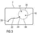
- FIG. 3 2 schematically shows an output unit 7 embodied as a display unit, on which two stop locations 17, 18 classified as grouped together, a corresponding destination area 20 with an edge 26 and a route 22 from a start location 28 to an edge location 24 on the edge 26 of the destination area 20 are.
- the target area 20 is circular in this case, but may instead be rectangular or have a different shape.
- Randort 24 preferably a location on the edge 26 of the target area 20 is determined such that the route 22 is as short as possible or a travel time to cover the route 22 is as low as possible.
- a first time threshold and a second time threshold are set for the above first evaluation criterion, and as a condition for classifying a location as a stopping place 17, 18 to be stored, it is predetermined that the vehicle 1 will stay in the place for at least the duration of the first Time threshold value with the engine off and the route guidance function of the navigation system 3 is switched off or at least for the duration of the second time threshold value with the engine switched off and the navigation system 3 switched on.
- the navigation control unit 5 For evaluating a location based on the first evaluation criterion, the navigation control unit 5 detects a time duration that stops the vehicle 1 at the location, and the detected time period is compared with the first time threshold if the engine of the vehicle 1 and the route guidance function of the navigation system 3 are turned off or the detected time period is compared with the second time threshold, if the engine of the vehicle 1 is turned off and the Destination guidance function of the navigation system 3 is turned on.
- the second time threshold is chosen to be greater than the first time threshold.
- an evaluation distance difference is given, and as a condition for grouping a plurality of stopping places 17, 18, it is predetermined that the positions of each pair of two of these stopping places 17, 18 are not more than the evaluation distance difference from each other. Accordingly, it is checked by the navigation control unit 5 for every two stopping places 17, 18 whether they are not more than the evaluation distance difference from each other to decide whether they are considered to be summarized. In this case, as a destination for destination locations 17, 18 classified as summarized, for example, a destination area 20 having the diameter of the predetermined evaluation distance difference is stored.
- a street name of a street at or in the vicinity of which the stopping place 17, 18 is located for example, a street name of a street at or in the vicinity of which the stopping place 17, 18 is located, and / or a name of a landmark located in a vicinity of the stopping place 17, 18 , and / or a name of a public building located in the vicinity of the stopping place 17, 18, and / or a place name of a place or a place in which the stopping place 17, 18 is located.
- each holding location 17, 18 it is further checked for each holding location 17, 18 whether an address database of a mobile device 15 connected via a second interface 12 to the navigation system 3, such as a mobile telephone and / or a tablet, for example a mobile device 15 of the user, is available for evaluation. For each available such address database is determined whether the address database has an address database entry with a contact address in the vicinity of the holding location 17, 18. For each contact address found in a vicinity of the holding location 17, 18, at least one piece of information of the associated address database entry is stored as additional information associated with the holding location 17, 18.
- an address database of a mobile device 15 connected via a second interface 12 to the navigation system 3, such as a mobile telephone and / or a tablet, for example a mobile device 15 of the user is available for evaluation. For each available such address database is determined whether the address database has an address database entry with a contact address in the vicinity of the holding location 17, 18. For each contact address found in a vicinity of the holding location 17, 18, at least one piece of information of the associated address database entry is stored as additional information associated with
- the second interface 12 may be configured to establish a connection to the additional mobile devices. For example, a connection with the mobile device of the user of the navigation system 3 is first established and then a connection with an additional mobile device of another vehicle occupant.
- a database entry of the database 10 with a travel destination which is probable for the journey is automatically ascertained, updated, and updated as a function of a current position of the vehicle 1 and / or of a travel direction of the journey and / or of a current time outputting a user-selectable destination by means of the output unit 7.
- This is in particular carried out when the user uses the vehicle 1 without having entered or selected a destination for the journey even when driving. The user then only needs to select a proposed destination to start a route guidance to the selected destination.
- a database entry is already stored, which has a job of the user as a destination and this destination is associated with a regular morning driving time (for example, 7 o'clock weekdays), for example, the destination is the user at a ride on this journey start time "Job" issued as a proposed destination.
- a new destination to be proposed is determined and output to the user, for example, a proposed destination that is among all Database entries of the database 10 represents a nearest destination in the current direction of travel.
- a proposed destination can be output which, among all database entries of the database 10, is one of the current vehicle position represents the nearest destination. Furthermore, when determining a destination to be proposed, it can be considered whether a particular mobile phone is coupled to the navigation system or whether the loading of the vehicle 1 indicates a longer journey.
- the proposed destinations are updated depending on the changes in the vehicle position of the vehicle 1 and the direction of travel of the drive and possibly changed.
Landscapes
- Engineering & Computer Science (AREA)
- Radar, Positioning & Navigation (AREA)
- Remote Sensing (AREA)
- Health & Medical Sciences (AREA)
- General Health & Medical Sciences (AREA)
- Social Psychology (AREA)
- Automation & Control Theory (AREA)
- Physics & Mathematics (AREA)
- General Physics & Mathematics (AREA)
- Navigation (AREA)
Abstract
Description
- Die Erfindung betrifft ein Navigationssystem zur Ermittlung und Ausgabe einer Fahrtroute für ein Fahrzeug und ein Verfahren zum Betreiben eines derartigen Navigationssystems.
- Bekannte Navigationssysteme für Fahrzeuge berechnen in effizienter Weise Fahrtrouten und führen darauf basierend Zielführungen durch, um einen Nutzer abhängig von Kartenmaterial und weiteren Informationsquellen mit möglichst effektiver Unterstützung zu einem vorgebbaren Fahrtziel zu führen. Als Zielführung wird ein Prozess bezeichnet, der den Nutzer entlang einer Fahrtroute leitet. Fahrtroutenberechnung und Zielführung werden hierin unter dem Begriff "Navigation" zusammengefasst.
- Dadurch erleichtert ein Navigationssystem einem Nutzer die Fahrt in unbekanntem Terrain und ermöglicht dem Nutzer, sich stärker auf das Verkehrsgeschehen zu konzentrieren, da die Routenführung vom Navigationssystem übernommen wird. Trotzdem ist die Hemmschwelle zur Nutzung eines Navigationssystems in einem dem Nutzer weitgehend bekannten Gebiet recht hoch. Das liegt daran, dass der Nutzer aufgrund seiner guten Kenntnis des Gebietes es möglicherweise als unverhältnismäßig aufwändig erachtet, für ein unbekanntes oder neues Ziel in diesem Gebiet eine Adresseingabe vorzunehmen oder irgendwann eine bestimmte Position abzulegen, beispielsweise durch Abspeichern einer aktuellen Position.
- Auf verschiedene Weise wird versucht, den Komfort und die Bedienung eines Navigationssystems zu verbessern und die Bereitschaft zur Verwendung eines Navigationssystems zu steigern. Es sind beispielsweise Navigationssysteme bekannt, die in Abhängigkeit von der Tageszeit, dem Wochentag und/oder dem aktuellen Standort wiederkehrende Fahrtrouten vorschlagen und so dem Nutzer die Eingabe erleichtern. Insbesondere wird versucht, die Navigation den Gewohnheiten des Nutzers anzupassen. Unter dem Begriff "selbst lernende Navigation" sind bereits einige Techniken bekannt und fließen in verschiedene Bereiche der Navigation ein, die den Nutzer mit Zusatzinformationen unterstützen oder eine Fahrtroute an bestimmte Gewohnheiten des Nutzers anpassen.
- Der Erfindung liegt die Aufgabe zu Grunde, ein insbesondere hinsichtlich seines Bedienungskomforts und seines Bedienungsumfangs verbessertes Navigationssystem zur Ermittlung und Ausgabe einer Fahrtroute für ein Fahrzeug und ein entsprechend verbessertes Verfahren zum Betreiben eines derartigen Navigationssystems anzugeben. Unter einem Fahrzeug wird hierin ein mobiles Verkehrsmittel verstanden, zum Beispiel ein Kraftfahrzeug oder ein Fahrrad, aber auch ein Luftfahrzeug oder ein Wasserfahrzeug.
- Die Aufgabe wird erfindungsgemäß hinsichtlich des Verfahrens durch die Merkmale des Anspruchs 1 und hinsichtlich des Navigationssystems durch die Merkmale des Anspruchs 11 gelöst.
- Vorteilhafte Ausgestaltungen der Erfindung sind Gegenstand der Unteransprüche.
- Mit dem erfindungsgemäßen Verfahren wird ein Navigationssystem eines Fahrzeugs betrieben, das zur Ermittlung und Ausgabe einer Fahrtroute zu einem von einem Nutzer des Navigationssystems vorgebbaren Fahrtziel ausgebildet ist. Dabei wird eine Datenbank für von dem Nutzer auswählbare Datenbankeinträge geführt, die jeweils ein Fahrtziel aufweisen, wobei die Datenbank in einer Speichereinheit gespeichert ist. Ferner wird ein Ort, an dem das Fahrzeug anhält, als ein zu speichernder Halteort eingestuft, wenn ein vorgegebenes erstes Bewertungskriterium erfüllt ist, und für jeden als Halteort eingestuften Ort wird automatisch eine Zielinformation ermittelt, welche eine Position des Halteortes und eine dem Halteort zugeordnete Zusatzinformation aufweist.
- Außerdem werden mehrere Halteorte als zusammenzufassen eingestuft, wenn ein vorgegebenes zweites Bewertungskriterium erfüllt ist. Die Zielinformationen für die Halteorte, die als zusammenzufassen eingestuft werden, werden automatisch zu einem Datenbankeintrag zusammengefasst und in der Datenbank gespeichert. Die Zielinformation für jeden Halteort, der nicht als mit einem anderen Halteort zusammenzufassen eingestuft wird, wird entweder als ein separater Datenbankeintrag der Datenbank oder unabhängig, das heißt getrennt, von der Datenbank gespeichert, zum Beispiel in einem von der Datenbank separierten elektronischen System in derselben Speichereinheit, oder in einer anderen Speichereinheit.
- Bei dem erfindungsgemäßen Verfahren wird also automatisch, d. h. ohne Veranlassung oder Einwirkung des Nutzers des Navigationssystems, eine Zielinformation, die die Position eines Halteortes, an welchem das Fahrzeug anhält, und eine dem Halteort zugeordnete Zusatzinformation aufweist, ermittelt und gespeichert, sofern der Halteort ein erstes Bewertungskriterium erfüllt. Ferner werden die für mehrere dieser Halteorte ermittelten Zielinformationen zu einem Datenbankeintrag zusammengefasst, sofern diese Halteorte ein zweites Bewertungskriterium erfüllen. Der Datenbankeintrag kann von dem Nutzer ausgewählt werden.
- Durch eine geeignete Wahl der Bewertungskriterien können dadurch für den Nutzer potenziell relevante Orte automatisch als von dem Nutzer auswählbare Fahrtziele gespeichert werden, ohne dass der Nutzer die Speicherung dieser Orte veranlassen oder durchführen muss. Das Verfahren ermöglicht daher eine automatische Erweiterung von dem Nutzer auswählbarer Fahrtziele des Navigationssystems, die die Nutzung des Navigationssystems erleichtert, indem sie dem Nutzer die Auswahl und Speicherung neuer potenziell relevanter Fahrtziele teilweise abnimmt. Dadurch werden der Komfort und die Bedienung des Navigationssystems verbessert. Außerdem werden durch eine Betätigung des Navigationssystems verursachte Ablenkungen des Nutzers von dem Verkehrsgeschehen und somit die Gefahr von Unfällen und gefährlichen Fahrmanövern reduziert.
- Eine Ausgestaltung der Erfindung sieht vor, dass ein erster Zeitschwellenwert und ein zweiter Zeitschwellenwert vorgegeben werden, und dass das erste Bewertungskriterium als eine Bedingung dafür, einen Ort als einen zu speichernden Halteort einzustufen, aufweist, dass das Fahrzeug an dem Ort wenigstens für die Dauer des ersten Zeitschwellenwertes mit ausgeschaltetem Motor und ausgeschalteter Zielführungsfunktion des Navigationssystems oder wenigstens für die Dauer des zweiten Zeitschwellenwertes mit ausgeschaltetem Motor und eingeschalteter Zielführungsfunktion des Navigationssystems verbleibt.
- Diese Ausgestaltung der Erfindung macht die Einstufung eines Ortes als einen zu speichernden Halteort von der Dauer des Anhaltens des Fahrzeugs und dem Ausschalten des Motors des Fahrzeugs abhängig. Dies ist vorteilhaft, da in der Regel nur diejenigen Orte interessante neue Fahrtziele sind, an denen das Fahrzeug längere Zeit abgestellt wird. Ferner vermag die vorgenannte Ausgestaltung der Erfindung zusätzlich zu berücksichtigen, ob die Zielführungsfunktion des Navigationssystems eingeschaltet ist. Dies berücksichtigt vorteilhaft, dass das Fahrtziel einer Fahrt bei einer eingeschalteten Zielführungsfunktion dem Navigationssystem bereits bekannt ist und es daher weniger wahrscheinlich ist, dass auf einer derartigen Fahrt potenziell relevante Fahrtziele, die dem Navigationssystem bisher noch unbekannt sind, angefahren werden.
- Alternativ dazu gilt das erste Bewertungskriterium dann als erfüllt, wenn das Fahrzeug für eine vorgegebene Zeitdauer an einer geografischen Position verbleibt, wenn das Fahrzeug von allen Fahrzeuginsassen verlassen wird, wenn ein Fahrzeugschlüssel von dem Fahrzeug entfernt wird oder wenn eine Wegfahrsperre des Fahrzeugs aktiviert wird.
- Eine weitere Ausgestaltung der Erfindung sieht vor, dass als Fahrtziel eines Datenbankeintrags für als zusammenzufassen eingestufte Halteorte ein die gespeicherten Positionen dieser Halteorte aufweisendes Zielgebiet in der Datenbank gespeichert wird.
- Diese Ausgestaltung ermöglicht vorteilhaft, ein mehrfach angefahrenes Zielgebiet als Fahrtziel in der Datenbank abzulegen, statt einzelne Orte in diesem Zielgebiet als separate Orte abzulegen.
- Eine Weitergestaltung der vorgenannten Ausgestaltung der Erfindung sieht vor, dass bei einer Auswahl eines Fahrtziels, das als ein Zielgebiet in der Datenbank gespeichert ist, eine Fahrtroute zu einem Randort auf einem Rand des Zielgebiets ermittelt wird.
- Diese Weitergestaltung berücksichtigt vorteilhaft, dass sich ein Nutzer in einem häufig angefahrenen Zielgebiet in der Regel bereits auskennt, so dass es genügt, eine Fahrtroute zu einem Randort auf einem Rand des Zielgebiets auszugeben.
- Eine weitere Ausgestaltung der Erfindung sieht vor, dass eine Bewertungsentfernungsdifferenz vorgegeben wird, und dass das zweite Bewertungskriterium als eine Bedingung dafür, mehrere Halteorte als zusammenzufassen einzustufen, aufweist, dass die Positionen jedes Paares dieser Halteorte nicht mehr als die Bewertungsentfernungsdifferenz voneinander entfernt sind. Das heißt, dass der Abstand zwischen den Positionen (Luftlinie) oder die kürzeste Verbindung zwischen den Positionen über Straßen oder Wege kleiner oder gleich der Bewertungsentfernungsdifferenz ist.
- Diese Ausgestaltung der Erfindung macht die Zusammenfassung verschiedener Halteorte zu einem Datenbankeintrag von einer räumlichen Nähe der Halteorte abhängig. Dies berücksichtigt vorteilhaft, dass eine Korrelation weit voneinander entfernter Orte unwahrscheinlich ist und eine Zuweisung eines gemeinsamen Fahrtziels zu weit voneinander entfernter Orte nicht sinnvoll ist.
- Dabei wird als Zielgebiet vorzugsweise ein Gebiet mit dem Durchmesser der vorgegebenen Bewertungsentfernungsdifferenz der oben bereits genannten Ausgestaltung der Erfindung gespeichert.
- Dadurch wird die Größe des Zielgebiets sinnvoll an die vorgegebene Bewertungsentfernungsdifferenz gekoppelt. Unter dem Durchmesser eines Gebiets wird dabei gemäß einer allgemeinen mathematischen Definition des Begriffs "Durchmesser" das Supremum aller Abstände je zweier Punkte des Gebiets verstanden. Der Begriff "Durchmesser" ist daher insbesondere nicht auf kreisförmige Gebiete beschränkt.
- Weitergestaltungen der beiden vorgenannten Ausgestaltungen der Erfindung sehen vor, dass eine Bewertungsuhrzeitdifferenz, eine Bewertungsanzahldifferenz und/oder eine Bewertungsbelegungsdifferenz vorgegeben werden und das zweite Bewertungskriterium als Bedingung dafür, Halteorte als zusammenzufassen einzustufen, aufweist, dass sich Uhrzeiten, zu denen die Halteorte erreicht werden, nicht mehr als die Bewertungsuhrzeitdifferenz voneinander unterscheiden, dass sich erfasste Fahrzeuginsassenanzahlen von Fahrzeuginsassen des Fahrzeugs bei dem Erreichen der Halteorte um nicht mehr als die Bewertungsanzahldifferenz voneinander unterscheiden, beziehungsweise dass sich erfasste Kofferraumbelegungen eines Kofferraums des Fahrzeugs bei dem Erreichen der Halteorte um nicht mehr als die Bewertungsbelegungsdifferenz voneinander unterscheiden.
- Diese Weitergestaltungen der beiden vorgenannten Ausgestaltungen der Erfindung ermöglichen vorteilhaft, mittels Verfeinerungen des zweiten Bewertungskriteriums weitere Aspekte zu berücksichtigen, die für oder gegen eine Zusammenfassung verschiedener Halteorte zu einem Datenbankeintrag sprechen. Insbesondere wird berücksichtigt, dass ähnliche Uhrzeiten, zu denen die Halteorte erreicht werden, und/oder ähnliche Fahrzeuginsassenanzahlen und/oder Kofferraumbelegungen bei dem Erreichen von Halteorten für eine Zusammenfassung der Halteorte zu einem Datenbankeintrag sprechen.
- Weitere Ausgestaltungen der Erfindung sehen vor, dass als eine einem Halteort zugeordnete Zusatzinformation ein Straßenname einer Straße, an der oder in einer Nähe derer sich der Halteort befindet, ein Name einer Sehenswürdigkeit, die sich in einer Nähe des Halteortes befindet, ein Name eines öffentlichen Gebäudes, das sich in einer Nähe des Halteortes befindet, und/oder ein Ortsname eines Orts oder eines Ortsteils, in dem sich der Halteort befindet, ermittelt und gespeichert werden.
- Diese Ausgestaltungen ermöglichen vorteilhaft, Halteorte mit sinnvollen Begriffen als Zusatzinformationen zu verknüpfen und erleichtern dem Nutzer dadurch die Verwendung der Datenbank.
- Eine weitere Ausgestaltung der Erfindung sieht vor, dass für jeden Halteort geprüft wird, ob eine Adressdatenbank eines Mobilgerätes, zum Beispiel eines Mobilgeräts des Nutzers oder eines anderen Fahrzeuginsassen, zur Auswertung verfügbar ist, und dass für jede verfügbare derartige Adressdatenbank ermittelt wird, ob die Adressdatenbank einen Adressdatenbankeintrag mit einer Kontaktadresse in einer Nähe des Halteortes aufweist. Ferner wird für jede dabei gefundene Kontaktadresse in einer Nähe des Halteortes zumindest eine Information des dazu gehörenden Adressdatenbankeintrags als eine dem Halteort zugeordnete Zusatzinformation gespeichert.
- Diese Ausgestaltung der Erfindung ermöglicht, Kontaktadressen des Nutzers mit Halteorten zu verknüpfen und zu deren Kennzeichnung zu verwenden. Dadurch können Halteorte sinnvoll mit individuellen Daten und Präferenzen des Nutzers korreliert werden.
- Eine weitere Ausgestaltung der Erfindung sieht vor, dass während einer Fahrt des Fahrzeugs automatisch in Abhängigkeit von einer aktuellen Position des Fahrzeugs und/oder von einer Fahrtrichtung der Fahrt und/oder von einer aktuellen Uhrzeit ein Datenbankeintrag der Datenbank mit einem für die Fahrt wahrscheinlichen Fahrtziel ermittelt, aktualisiert und als ein von dem Nutzer auswählbares Fahrtziel ausgegeben wird.
- Diese Ausgestaltung der Erfindung ermöglicht es, dem Nutzer des Navigationssystems automatisch während einer Fahrt Vorschläge für wahrscheinliche Fahrtziele zu unterbreiten, die der Nutzer auswählen kann. Die Ausgestaltung richtet sich insbesondere auf Fahrten, für die der Nutzer bei Fahrtantritt kein Fahrtziel ausgewählt hat, und nimmt dem Nutzer somit die Eingabe eines Fahrtziels ab. Der Nutzer braucht also vorteilhaft nur noch automatisch vorgeschlagene Fahrtziele zu prüfen und gegebenenfalls ein vorgeschlagenes Fahrtziel auszuwählen.
- Ein erfindungsgemäßes Navigationssystem umfasst eine Navigationssteuereinheit zur Ermittlung einer Fahrtroute für ein Fahrzeug zu einem von einem Nutzer des Navigationssystems vorgebbaren Fahrtziel, eine Ausgabeeinheit zur Ausgabe einer ermittelten Fahrtroute und eine Speichereinheit zur Speicherung einer Datenbank, in der von dem Nutzer auswählbare Datenbankeinträge, die jeweils ein Fahrtziel aufweisen, speicherbar sind.
- Dabei ist die Navigationssteuereinheit dazu ausgebildet, einen Ort, an dem das Fahrzeug anhält, zu ermitteln und als einen zu speichernden Halteort einzustufen, wenn ein vorgegebenes erstes Bewertungskriterium erfüllt ist, für jeden als Halteort eingestuften Ort automatisch eine Zielinformation, die eine Position des Halteortes und eine dem Halteort zugeordnete Zusatzinformation aufweist, zu ermitteln, mehrere Halteorte als zusammenzufassen einzustufen, wenn ein vorgegebenes zweites Bewertungskriterium erfüllt ist, die Zielinformationen für die Halteorte, die als zusammenzufassen eingestuft werden, zu einem Datenbankeintrag zusammenzufassen und in der Datenbank zu speichern, und die ermittelte Zielinformation für jeden Halteort, der nicht als mit einem anderen Halteort zusammenzufassen eingestuft wird, entweder als einen separaten Datenbankeintrag der Datenbank oder unabhängig von der Datenbank zu speichern.
- Ein derartiges Navigationssystem ermöglicht dessen Betreiben gemäß dem erfindungsgemäßen Verfahren mit den oben genannten Vorteilen.
- Ausführungsbeispiele der Erfindung werden im Folgenden anhand von Zeichnungen näher erläutert.
- Dabei zeigen:
- Figur 1
- ein Blockdiagramm eines Fahrzeugs mit einem in dem Fahrzeug angeordneten Navigationssystem,
- Figur 2
- ein Flussdiagramm eines Verfahrens zum Betreiben eines Navigationssystems, und
- Figur 3
- eine Ausgabeeinheit eines Navigationssystems, auf dem eine Fahrtroute zu einem Randort eines Zielgebiets dargestellt ist.
- Einander entsprechende Teile sind in den Figuren mit den gleichen Bezugszeichen versehen.
-
Figur 1 zeigt ein Blockdiagramm eines Fahrzeugs 1 mit einem in dem Fahrzeug angeordneten Navigationssystem 3 zur Ermittlung und Ausgabe einer Fahrtroute für das Fahrzeug 1 zu einem von einem Nutzer des Navigationssystems 3 vorgebbaren Fahrtziel. - Das Navigationssystem 3 umfasst eine Navigationssteuereinheit 5 zur Ermittlung einer Fahrtroute zu einem vorgebbaren Fahrtziel, eine Ausgabeeinheit 7 zur Ausgabe einer ermittelten Fahrtroute und eine Speichereinheit 9 zur Speicherung insbesondere einer Datenbank 10, in der von dem Nutzer auswählbare Datenbankeinträge, die jeweils ein Fahrtziel aufweisen, speicherbar sind. Optional umfasst das Navigationssystem 3 ferner eine erste Schnittstelle 11, über die das Navigationssystem 3 mit einem Sensorsystem 13 des Fahrzeugs 1 verbindbar ist, und/oder eine zweite Schnittstelle 12, über die das Navigationssystem 3 mit einem Mobilgerät 15, zum Beispiel einem Mobilgerät 15 des Nutzers des Navigationssystems 3, verbindbar ist. Die Schnittstellen 11, 12 und/oder die Speichereinheit 9 können in die Navigationssteuereinheit 5 integriert sein.
- Im Folgenden wird neben
Figur 1 auch aufFigur 2 Bezug genommen. -
Figur 2 zeigt ein Flussdiagramm eines Verfahrens zum Betreiben des inFigur 1 dargestellten Navigationssystems 3, das in dem Fahrzeug 1 angeordnet ist. Bei dem Verfahren werden ein erstes Bewertungskriterium und ein zweites Bewertungskriterium vorgegeben. Anhand des ersten Bewertungskriteriums wird bewertet, ob ein Ort, an dem das Fahrzeug 1 anhält, als ein zu speichernder Halteort eingestuft wird. Anhand des zweiten Bewertungskriteriums wird entschieden, ob mehrere Halteorte als zusammenzufassen eingestuft werden. - Eine Initialisierung S0 des Verfahrens wird an einen Fahrtbeginn einer Fahrt des Fahrzeugs 1 gekoppelt. Ein Fahrtbeginn wird von der Navigationssteuereinheit 5 beispielsweise durch eine Auswertung von Signalen eines eine Geschwindigkeit des Fahrzeugs 1 erfassenden Geschwindigkeitssensors des Sensorsystems 13 erkannt, die dem Navigationssystem 3 über die erste Schnittstelle 11 übermittelt werden. Alternativ oder zusätzlich wird ein Fahrtbeginn von der Navigationssteuereinheit 5 beispielsweise durch eine Auswertung von Funksignalen, z. B. von GPS-Signalen (GPS = Global Positioning System) erkannt, die die Navigationssteuereinheit 5 zur Bestimmung einer Position des Fahrzeugs 1 empfängt und auswertet.
- Danach wird in einem ersten Verfahrensschritt S1 geprüft, ob das Fahrzeug 1 anhält, das heißt angehalten hat. Der erste Verfahrensschritt S1 wird solange wiederholt, bis erkannt wird, dass das Fahrzeug 1 anhält. Die Wiederholung kann in einem bestimmten zeitlichen Abstand erfolgen, zum Beispiel in einem Abstand von 60 Sekunden, so dass ein Anhalten sicher erkannt wird. Auch das Anhalten des Fahrzeugs 1 wird von der Navigationssteuereinheit 5 beispielsweise durch eine Auswertung von Signalen eines eine Geschwindigkeit des Fahrzeugs 1 erfassenden Geschwindigkeitssensors des Sensorsystems 13 erkannt, die dem Navigationssystem 3 über eine erste Schnittstelle 11 übermittelt werden, und/oder durch eine Auswertung von Funksignalen, die es zur Bestimmung einer Position des Fahrzeugs 1 empfängt und auswertet. Wenn erkannt wird, dass das Fahrzeug 1 anhält, wird in einem zweiten Verfahrensschritt S2 anhand des ersten Bewertungskriteriums bewertet, ob der Ort, an dem das Fahrzeug anhält, als ein zu speichernder Halteort eingestuft wird. Wenn der Ort nicht als ein Halteort eingestuft wird, wird das Verfahren beendet und nach einem erneuten Fahrtbeginn neu initialisiert.
- Wenn ein Ort in dem zweiten Verfahrensschritt S2 als Halteort eingestuft wird, wird in einem dritten Verfahrensschritt S3 eine Zielinformation, die eine Position des Halteortes und eine dem Halteort zugeordnete Zusatzinformation aufweist, ermittelt.
- In einem vierten Verfahrensschritt S4 wird anschließend anhand des zweiten Bewertungskriteriums bewertet, ob der Halteort als mit einem bereits bekannten Halteort zusammenzufassen eingestuft wird.
- Wenn der Halteort in dem vierten Verfahrensschritt S4 als mit einem anderen Halteort zusammenzufassen eingestuft wird, werden in einem fünften Verfahrensschritt S5 die Zielinformationen der als zusammenzufassen eingestuften Halteorte zu einem Datenbankeintrag zusammengefasst und in der Datenbank 10 gespeichert. Andernfalls wird in einem sechsten Verfahrensschritt S6 die für den Halteort ermittelte Zielinformation entweder als ein separater neuer Datenbankeintrag in der Datenbank 10 oder unabhängig von der Datenbank 10 gespeichert, zum Beispiel in einem von der Datenbank getrennten elektronischen System. Sowohl nach dem fünften Verfahrensschritt S5 als auch nach dem sechsten Verfahrensschritt S6 wird das Verfahren beendet und nach einem erneuten Fahrtbeginn neu initialisiert.
- Alle Verfahrensschritte S1 bis S6 werden automatisch, d. h. ohne Veranlassung oder Einwirkung des Nutzers des Navigationssystems 3 von der Navigationssteuereinheit 5 ausgeführt. Dadurch werden durch das Navigationssystem 3 automatisch Fahrtziele, die für den Nutzer potenziell relevant sind, gespeichert und für den Nutzer auswählbar gemacht, ohne dass der Nutzer diese Speicherung selbst veranlassen oder durchführen muss.
- Als Fahrtziel eines Datenbankeintrags für als zusammenzufassen eingestufte Halteorte wird vorzugsweise ein die gespeicherten Positionen dieser Halteorte aufweisendes Zielgebiet in der Datenbank 10 gespeichert. Die Navigationssteuereinheit 5 ist beispielsweise dazu ausgebildet, bei einer von dem Nutzer vorgenommenen Auswahl eines Fahrtziels, das als ein derartiges Zielgebiet in der Datenbank 10 gespeichert ist, eine Fahrtroute zu einem Randort auf einem Rand des Zielgebiets zu ermitteln.
- Im Folgenden wird neben
Figur 1 auch aufFigur 3 Bezug genommen. -
Figur 3 zeigt schematisch eine als eine Anzeigeeinheit ausgebildete Ausgabeeinheit 7, auf der zwei als zusammenzufassen eingestufte Halteorte 17, 18, ein dazu gehöriges Zielgebiet 20 mit einem Rand 26 sowie eine Fahrtroute 22 von einem Startort 28 zu einem Randort 24 auf dem Rand 26 des Zielgebiets 20 dargestellt sind. - Das Zielgebiet 20 ist in diesem Fall kreisförmig ausgebildet, kann jedoch stattdessen rechteckig ausgebildet sein oder eine andere Form haben. Als Randort 24 wird vorzugsweise ein Ort auf dem Rand 26 des Zielgebiets 20 derart ermittelt, dass die Fahrtroute 22 möglichst kurz ist oder eine Fahrzeit zur Zurücklegung der Fahrtroute 22 möglichst gering ist.
- Für das oben genannte erste Bewertungskriterium werden beispielsweise ein erster Zeitschwellenwert und ein zweiter Zeitschwellenwert vorgegeben, und als Bedingung dafür, einen Ort als einen zu speichernden Halteort 17, 18 einzustufen, wird vorgegeben, dass das Fahrzeug 1 an dem Ort wenigstens für die Dauer des ersten Zeitschwellenwertes mit ausgeschaltetem Motor und ausgeschalteter Zielführungsfunktion des Navigationssystems 3 oder wenigstens für die Dauer des zweiten Zeitschwellenwertes mit ausgeschaltetem Motor und eingeschalteter Zielführungsfunktion des Navigationssystems 3 anhält.
- Zur Bewertung eines Ortes anhand des ersten Bewertungskriteriums wird von der Navigationssteuereinheit 5 eine Zeitdauer erfasst, die das Fahrzeug 1 an dem Ort anhält, und die erfasste Zeitdauer wird mit dem ersten Zeitschwellenwert verglichen, falls der Motor des Fahrzeugs 1 und die Zielführungsfunktion des Navigationssystems 3 ausgeschaltet sind, oder die erfasste Zeitdauer wird mit dem zweiten Zeitschwellenwert verglichen, falls der Motor des Fahrzeugs 1 ausgeschaltet ist und die Zielführungsfunktion des Navigationssystems 3 eingeschaltet ist. Typischerweise wird der zweite Zeitschwellenwert größer als der erste Zeitschwellenwert gewählt.
- Für das oben genannte zweite Bewertungskriterium wird beispielsweise eine Bewertungsentfernungsdifferenz vorgegeben, und als eine Bedingung dafür, mehrere Halteorte 17, 18 als zusammenzufassen einzustufen, wird vorgegeben, dass die Positionen jedes Paares zweier dieser Halteorte 17, 18 nicht mehr als die Bewertungsentfernungsdifferenz voneinander entfernt sind. Dementsprechend wird von der Navigationssteuereinheit 5 für je zwei Halteorte 17, 18 geprüft, ob sie nicht mehr als die Bewertungsentfernungsdifferenz voneinander entfernt sind, um zu entscheiden, ob sie als zusammenzufassen eingestuft werden. In diesem Fall wird als Fahrtziel für als zusammenzufassen eingestufte Halteorte 17, 18 beispielsweise ein Zielgebiet 20 mit dem Durchmesser der vorgegebenen Bewertungsentfernungsdifferenz gespeichert.
- Alternativ dazu kann das zweite Bewertungskriterium andere Bedingungen dafür aufweisen, Halteorte 17, 18 als zusammenzufassen einzustufen. Diese Bedingungen werden in den folgenden Beispielen erläutert:
- In einem Beispiel wird eine Bewertungsuhrzeitdifferenz vorgegeben, und als Bedingung dafür, Halteorte 17, 18 als zusammenzufassen einzustufen, wird verwendet, dass sich Uhrzeiten, zu denen die Halteorte 17, 18 erreicht werden, nicht mehr als die Bewertungsuhrzeitdifferenz voneinander unterscheiden. In diesem Fall werden dementsprechend Uhrzeiten, zu denen die Halteorte 17, 18 erreicht werden, erfasst und verglichen.
- In einem anderen Beispiel wird eine Bewertungsanzahldifferenz vorgegeben, und als Bedingung dafür, Halteorte 17, 18 als zusammenzufassen einzustufen, wird verwendet, dass sich erfasste Fahrzeuginsassenanzahlen von Fahrzeuginsassen des Fahrzeugs 1 bei dem Erreichen der Halteorte 17, 18 um nicht mehr als die Bewertungsanzahldifferenz voneinander unterscheiden. Dies setzt voraus, dass Fahrzeuginsassenanzahlen von Fahrzeuginsassen des Fahrzeugs 1 erfasst werden. Eine Fahrzeuginsassenanzahl wird von der Navigationssteuereinheit 5 beispielsweise durch eine Auswertung von dem Navigationssystem 3 über eine erste Schnittstelle 11 übermittelten Signalen geeigneter Sensoren des Fahrzeugs 1 ermittelt, beispielsweise von Sensoren zur Erfassung einer Sitzplatzbelegung und/oder Gurtbenutzung und/oder eines einen Fahrzeuginnenraum des Fahrzeugs 1 erfassenden optischen Sensors.
- In einem weiteren Beispiel wird eine Bewertungsbelegungsdifferenz vorgegeben, und als Bedingung dafür, Halteorte 17, 18 als zusammenzufassen einzustufen, wird verwendet, dass sich erfasste Kofferraumbelegungen eines Kofferraums des Fahrzeugs 1 bei dem Erreichen der Halteorte 17, 18 um nicht mehr als die Bewertungsbelegungsdifferenz voneinander unterscheiden. Eine Kofferraumbelegung wird von der Navigationssteuereinheit 5 beispielsweise durch eine Auswertung von dem Navigationssystem 3 über eine erste Schnittstelle 11 übermittelten Signalen eines geeigneten Sensors des Fahrzeugs 1 ermittelt, der eine Kofferraumbeladung erfasst.
- In einer anderen Ausgestaltung der Erfindung wird als Bedingung dafür, Halteorte 17, 18 als zusammenzufassen einzustufen, eine Kombination aus mehreren der oben genannten Bedingungen, Halteorte 17, 18 als zusammenzufassen einzustufen, verwendet.
- Als eine dem Halteort 17, 18 zugeordnete Zusatzinformation wird beispielsweise ein Straßenname einer Straße, an der oder in einer Nähe derer sich der Halteort 17, 18 befindet, und/oder ein Name einer Sehenswürdigkeit, die sich in einer Nähe des Halteortes 17, 18 befindet, und/oder ein Name eines öffentlichen Gebäudes, das sich in einer Nähe des Halteortes 17, 18 befindet, und/oder ein Ortsname eines Orts oder eines Ortsteils, in dem sich der Halteort 17, 18 befindet, ermittelt.
- Optional wird ferner für jeden Halteort 17, 18 geprüft, ob eine Adressdatenbank eines über eine zweite Schnittstelle 12 mit dem Navigationssystem 3 verbundenen Mobilgerätes 15 wie eines Mobiltelefons und/oder eines Flachrechners (engl.: Tablet), zum Beispiel eines Mobilgerätes 15 des Nutzers, zur Auswertung verfügbar ist. Für jede verfügbare derartige Adressdatenbank wird ermittelt, ob die Adressdatenbank einen Adressdatenbankeintrag mit einer Kontaktadresse in einer Nähe des Halteortes 17, 18 aufweist. Für jede dabei gefundene Kontaktadresse in einer Nähe des Halteortes 17, 18 wird zumindest eine Information des dazu gehörenden Adressdatenbankeintrags als eine dem Halteort 17, 18 zugeordnete Zusatzinformation gespeichert.
- Alternativ oder zusätzlich dazu kann ermittelt werden, ob und welche anderen Kommunikationsgeräte mit einem Mobilgerät 15 beim Erreichen des Halteortes 17, 18 verbunden sind und dies wird als eine dem Halteort 17, 18 zugeordnete Zusatzinformation gespeichert. Sind weitere Adressdatenbanken zusätzlicher Mobilgeräte verfügbar, kann die zweite Schnittstelle 12 dazu eingerichtet sein, eine Verbindung zu den zusätzlichen Mobilgeräten aufzubauen. Zum Beispiel wird zunächst eine Verbindung mit dem Mobilgerät des Nutzers des Navigationssystems 3 aufgebaut und anschließend eine Verbindung mit einem zusätzlichen Mobilgerät eines weiteren Fahrzeuginsassen.
- Vorzugsweise wird während einer Fahrt des Fahrzeugs 1 automatisch in Abhängigkeit von einer aktuellen Position des Fahrzeugs 1 und/oder von einer Fahrtrichtung der Fahrt und/oder von einer aktuellen Uhrzeit ein Datenbankeintrag der Datenbank 10 mit einem für die Fahrt wahrscheinlichen Fahrtziel ermittelt, aktualisiert und als ein von dem Nutzer auswählbares Fahrtziel mittels der Ausgabeeinheit 7 ausgegeben. Dies wird insbesondere durchgeführt, wenn der Nutzer das Fahrzeug 1 nutzt, ohne selbst bei Fahrtantritt ein Fahrtziel für die Fahrt eingegeben oder ausgewählt zu haben. Der Nutzer braucht dann nur noch ein vorgeschlagenes Fahrtziel auswählen, um eine Zielführung zu dem ausgewählten Fahrtziel zu starten.
- Wenn z. B. in der Datenbank 10 bereits ein Datenbankeintrag gespeichert ist, der als Fahrtziel eine Arbeitsstelle des Nutzers aufweist und dieses Fahrtziel mit einer regelmäßigen morgendlichen Fahrtantrittszeit (beispielsweise wochentags 7 Uhr) verknüpft ist, wird an den Nutzer bei einem Fahrtantritt zu dieser Fahrtantrittszeit beispielsweise das Fahrtziel "Arbeitsstelle" als vorgeschlagenes Fahrtziel ausgegeben. Wenn während der Fahrt jedoch festgestellt wird, dass die Fahrt wahrscheinlich ein anderes Fahrtziel hat, da die Fahrtrichtung der Fahrt von der Richtung zu der Arbeitsstelle abweicht, wird ein neues vorzuschlagendes Fahrtziel ermittelt und an den Nutzer ausgegeben, beispielsweise ein vorgeschlagenes Fahrtziel, das unter allen Datenbankeinträgen der Datenbank 10 ein in der aktuellen Fahrtrichtung nächstgelegenes Fahrtziel repräsentiert.
- Alternativ oder zusätzlich kann ein vorgeschlagenes Fahrtziel ausgegeben werden, das unter allen Datenbankeinträgen der Datenbank 10 ein der aktuellen Fahrzeugposition nächstgelegenes Fahrtziel repräsentiert. Ferner kann bei der Ermittlung eines vorzuschlagenden Fahrtziels berücksichtigt werden, ob ein bestimmtes Handy mit dem Navigationssystem gekoppelt ist, oder ob die Beladung des Fahrzeugs 1 auf eine längere Reise hindeutet. Die vorgeschlagenen Fahrtziele werden in Abhängigkeit von den Änderungen der Fahrzeugposition des Fahrzeugs 1 und der Fahrtrichtung der Fahrt aktualisiert und gegebenenfalls geändert.
Claims (11)
- Verfahren zum Betreiben eines Navigationssystems (3) eines Fahrzeugs (1), das zur Ermittlung und Ausgabe einer Fahrtroute (22) zu einem von einem Nutzer des Navigationssystems (3) vorgebbaren Fahrtziel ausgebildet ist, wobei- eine Datenbank (10) für von dem Nutzer auswählbare Datenbankeinträge, die jeweils ein Fahrtziel aufweisen, geführt wird,- ein Ort, an dem das Fahrzeug (1) anhält, als ein zu speichernder Halteort (17, 18) eingestuft wird, wenn ein vorgegebenes erstes Bewertungskriterium erfüllt ist,- für jeden als Halteort (17, 18) eingestuften Ort automatisch eine Zielinformation, die eine Position des Halteortes (17, 18) und eine dem Halteort (17, 18) zugeordnete Zusatzinformation aufweist, ermittelt wird,- mehrere Halteorte (17, 18) als zusammenzufassen eingestuft werden, wenn ein vorgegebenes zweites Bewertungskriterium erfüllt ist,- die Zielinformationen für die Halteorte (17, 18), die als zusammenzufassen eingestuft werden, automatisch zu einem Datenbankeintrag zusammengefasst und in der Datenbank (10) gespeichert werden, und- die Zielinformation für jeden Halteort (17, 18), der nicht als mit einem anderen Halteort (17, 18) zusammenzufassen eingestuft wird, entweder als ein separater Datenbankeintrag der Datenbank (10) oder unabhängig von der Datenbank (10) gespeichert wird.
- Verfahren nach Anspruch 1,
dadurch gekennzeichnet, dass ein erster Zeitschwellenwert und ein zweiter Zeitschwellenwert vorgegeben werden und das erste Bewertungskriterium als erfüllt gilt, wenn das Fahrzeug (1) an dem Ort für die Dauer des ersten Zeitschwellenwertes mit ausgeschaltetem Motor und ausgeschalteter Zielführungsfunktion des Navigationssystems (3) anhält oder das Fahrzeug (1) an dem Ort für die Dauer des zweiten Zeitschwellenwertes mit ausgeschaltetem Motor und eingeschalteter Zielführungsfunktion des Navigationssystems (3) anhält. - Verfahren nach einem der vorhergehenden Ansprüche,
dadurch gekennzeichnet, dass als Fahrtziel eines Datenbankeintrags für als zusammenzufassen eingestufte Halteorte (17, 18) ein die gespeicherten Positionen dieser Halteorte (17, 18) aufweisendes Zielgebiet (20) in der Datenbank (10) gespeichert wird. - Verfahren nach Anspruch 3,
dadurch gekennzeichnet, dass bei einer Auswahl des Fahrtziels, das als das Zielgebiet (20) in der Datenbank (10) gespeichert ist, eine Fahrtroute (22) zu einem Randort (24) auf einem Rand (26) des Zielgebiets (20) ermittelt wird. - Verfahren nach einem der vorhergehenden Ansprüche,
dadurch gekennzeichnet, dass eine Bewertungsentfernungsdifferenz vorgegeben wird und das zweite Bewertungskriterium als erfüllt gilt, wenn die Positionen jedes Paares der Halteorte (17, 18) nicht mehr als die Bewertungsentfernungsdifferenz voneinander entfernt sind. - Verfahren nach Anspruch 5 und einem der Ansprüche 3 oder 4,
dadurch gekennzeichnet, dass als Zielgebiet (20) ein Gebiet mit dem Durchmesser der vorgegebenen Bewertungsentfernungsdifferenz gespeichert wird. - Verfahren nach Anspruch 5 oder 6,
dadurch gekennzeichnet, dass eine Bewertungsuhrzeitdifferenz, eine Bewertungsanzahldifferenz und/oder eine Bewertungsbelegungsdifferenz vorgegeben werden und das zweite Bewertungskriterium als erfüllt gilt, wenn sich Uhrzeiten, zu denen die Halteorte (17, 18) erreicht werden, um nicht mehr als die Bewertungsuhrzeitdifferenz voneinander unterscheiden, wenn sich erfasste Fahrzeuginsassenanzahlen von Fahrzeuginsassen des Fahrzeugs (1) bei dem Erreichen der Halteorte (17, 18) um nicht mehr als die Bewertungsanzahldifferenz voneinander unterscheiden, beziehungsweise wenn sich erfasste Kofferraumbelegungen eines Kofferraums des Fahrzeugs (1) bei dem Erreichen der Halteorte (17, 18) um nicht mehr als die Bewertungsbelegungsdifferenz voneinander unterscheiden. - Verfahren nach einem der vorhergehenden Ansprüche,
dadurch gekennzeichnet, dass als Zusatzinformation ein Straßenname einer Straße, an der oder in einer Nähe derer sich der Halteort (17, 18) befindet, ein Name einer Sehenswürdigkeit, die sich in einer Nähe des Halteortes (17, 18) befindet, ein Name eines öffentlichen Gebäudes, das sich in einer Nähe des Halteortes (17, 18) befindet, und/oder ein Ortsname eines Orts oder eines Ortsteils, in dem sich der Halteort (17, 18) befindet, ermittelt und gespeichert werden. - Verfahren nach einem der vorhergehenden Ansprüche,
dadurch gekennzeichnet, dass für jeden Halteort (17, 18) geprüft wird, ob eine Adressdatenbank eines Mobilgerätes (15) zur Auswertung verfügbar ist, und, wenn das der Fall ist, für die Adressdatenbank ermittelt wird, ob die Adressdatenbank einen Adressdatenbankeintrag mit einer Kontaktadresse in einer Nähe des Halteortes (17, 18) aufweist, und, wenn das der Fall ist, für die Kontaktadresse eine Information des dazu gehörenden Adressdatenbankeintrags als eine dem Halteort (17, 18) zugeordnete Zusatzinformation gespeichert wird. - Verfahren nach einem der vorhergehenden Ansprüche,
dadurch gekennzeichnet, dass während einer Fahrt des Fahrzeugs (1) automatisch in Abhängigkeit von einer aktuellen Position des Fahrzeugs (1) und/oder von einer Fahrtrichtung der Fahrt und/oder von einer aktuellen Uhrzeit ein Datenbankeintrag der Datenbank (10) mit einem für die Fahrt wahrscheinlichen Fahrtziel ermittelt, aktualisiert und als ein von dem Nutzer auswählbares Fahrtziel ausgegeben wird. - Navigationssystem (3), umfassend- eine Navigationssteuereinheit (5) zur Ermittlung einer Fahrtroute (22) für ein Fahrzeug (1) zu einem von einem Nutzer des Navigationssystems (3) vorgebbaren Fahrtziel,- eine Ausgabeeinheit (7) zur Ausgabe einer ermittelten Fahrtroute (22) und- eine Speichereinheit (9) zur Speicherung einer Datenbank (10), in der von dem Nutzer auswählbare Datenbankeinträge, die jeweils ein Fahrtziel aufweisen, speicherbar sind,wobei die Navigationssteuereinheit (5) dazu ausgebildet ist,- einen Ort, an dem das Fahrzeug (1) anhält, zu ermitteln und als einen zu speichernden Halteort (17, 18) einzustufen, wenn ein vorgegebenes erstes Bewertungskriterium erfüllt ist,- für jeden als Halteort (17, 18) eingestuften Ort automatisch eine Zielinformation, die eine Position des Halteortes (17, 18) und eine dem Halteort (17, 18) zugeordnete Zusatzinformation aufweist, zu ermitteln,- mehrere Halteorte (17, 18) als zusammenzufassen einzustufen, wenn ein vorgegebenes zweites Bewertungskriterium erfüllt ist,- die Zielinformationen für die Halteorte (17, 18), die als zusammenzufassen eingestuft werden, zu einem Datenbankeintrag zusammenzufassen und in der Datenbank (10) zu speichern, und- die Zielinformation für jeden Halteort (17, 18), der nicht als mit einem anderen Halteort (17, 18) zusammenzufassen eingestuft wird, entweder als einen separaten Datenbankeintrag der Datenbank (10) oder unabhängig von der Datenbank (10) zu speichern.
Priority Applications (1)
| Application Number | Priority Date | Filing Date | Title |
|---|---|---|---|
| EP18020111.3A EP3410072A1 (de) | 2015-03-18 | 2016-03-18 | Ermitteln einer zusatzinformation zu einem halteort |
Applications Claiming Priority (1)
| Application Number | Priority Date | Filing Date | Title |
|---|---|---|---|
| DE102015003476.6A DE102015003476A1 (de) | 2015-03-18 | 2015-03-18 | Navigationssystem zur Ermittlung und Ausgabe einer Fahrtroute |
Related Child Applications (2)
| Application Number | Title | Priority Date | Filing Date |
|---|---|---|---|
| EP18020111.3A Division EP3410072A1 (de) | 2015-03-18 | 2016-03-18 | Ermitteln einer zusatzinformation zu einem halteort |
| EP18020111.3A Division-Into EP3410072A1 (de) | 2015-03-18 | 2016-03-18 | Ermitteln einer zusatzinformation zu einem halteort |
Publications (2)
| Publication Number | Publication Date |
|---|---|
| EP3070433A1 true EP3070433A1 (de) | 2016-09-21 |
| EP3070433B1 EP3070433B1 (de) | 2018-05-09 |
Family
ID=55586221
Family Applications (2)
| Application Number | Title | Priority Date | Filing Date |
|---|---|---|---|
| EP16161117.3A Active EP3070433B1 (de) | 2015-03-18 | 2016-03-18 | Navigationssystem zur ermittlung und ausgabe einer fahrtroute |
| EP18020111.3A Withdrawn EP3410072A1 (de) | 2015-03-18 | 2016-03-18 | Ermitteln einer zusatzinformation zu einem halteort |
Family Applications After (1)
| Application Number | Title | Priority Date | Filing Date |
|---|---|---|---|
| EP18020111.3A Withdrawn EP3410072A1 (de) | 2015-03-18 | 2016-03-18 | Ermitteln einer zusatzinformation zu einem halteort |
Country Status (2)
| Country | Link |
|---|---|
| EP (2) | EP3070433B1 (de) |
| DE (1) | DE102015003476A1 (de) |
Citations (3)
| Publication number | Priority date | Publication date | Assignee | Title |
|---|---|---|---|---|
| JPH10176929A (ja) * | 1996-12-18 | 1998-06-30 | Harness Sogo Gijutsu Kenkyusho:Kk | 登録地の自動登録ナビゲーションシステム |
| JP2006275958A (ja) * | 2005-03-30 | 2006-10-12 | Xanavi Informatics Corp | ナビゲーション装置 |
| DE102008005796A1 (de) * | 2008-01-23 | 2009-07-30 | Navigon Ag | Verfahren zum Betrieb eines Navigationssystems und Verfahren zur Erstellung einer Datenbank mit potentiellen Zielpunkten und Navigationsgerät |
-
2015
- 2015-03-18 DE DE102015003476.6A patent/DE102015003476A1/de not_active Withdrawn
-
2016
- 2016-03-18 EP EP16161117.3A patent/EP3070433B1/de active Active
- 2016-03-18 EP EP18020111.3A patent/EP3410072A1/de not_active Withdrawn
Patent Citations (3)
| Publication number | Priority date | Publication date | Assignee | Title |
|---|---|---|---|---|
| JPH10176929A (ja) * | 1996-12-18 | 1998-06-30 | Harness Sogo Gijutsu Kenkyusho:Kk | 登録地の自動登録ナビゲーションシステム |
| JP2006275958A (ja) * | 2005-03-30 | 2006-10-12 | Xanavi Informatics Corp | ナビゲーション装置 |
| DE102008005796A1 (de) * | 2008-01-23 | 2009-07-30 | Navigon Ag | Verfahren zum Betrieb eines Navigationssystems und Verfahren zur Erstellung einer Datenbank mit potentiellen Zielpunkten und Navigationsgerät |
Also Published As
| Publication number | Publication date |
|---|---|
| DE102015003476A1 (de) | 2016-09-22 |
| EP3410072A1 (de) | 2018-12-05 |
| EP3070433B1 (de) | 2018-05-09 |
Similar Documents
| Publication | Publication Date | Title |
|---|---|---|
| DE112009001449B4 (de) | Fahrzeugnavigationsvorrichtung | |
| DE102010043682A1 (de) | Verfahren und Vorrichtung zum Ermitteln einer Zielführungsroute für ein Fahrzeug zwischen einem Startort und einem Zielort mit Ankunft an dem Zielort innerhalb eines vorbestimmten Zeitintervalls | |
| DE102017220116A1 (de) | Verfahren und Vorrichtung um einen schnellen Halt eines autonom fahrenden Fahrzeugs zu ermöglichen | |
| EP3034358B1 (de) | Fahrerassistenzeinrichtung für ein kraftfahrzeug und verfahren zum betreiben einer solchen | |
| DE102016205319A1 (de) | Fahrzeugabfahrtunterstützungssystem und verfahren | |
| WO2012175254A1 (de) | Verfahren und vorrichtung zur bestimmung einer tauglichkeit einer route | |
| DE102013212776A1 (de) | Routenplanungsverfahren und Routenplanungsvorrichtung zum Planen einer Fahrtroute für ein Fahrzeug, Computerprogramm und Computerprodukt | |
| DE102015015277A1 (de) | Technik zum automatisierten Anhalten eines Fahrzeugs in einem Zielbereich | |
| DE102017100061A1 (de) | Verfahren zum Unterstützen eines Fahrers eines Kraftfahrzeugs beim Einparken unter Verwendung einer Fahrerassistenzvorrichtung, entsprechendes Computerprogrammprodukt und Fahrerassistenzvorrichtung | |
| WO2007112849A2 (de) | Navigationsanordnung und navigationsverfahren fur ein kraftfahrzeug | |
| DE102018220332A1 (de) | Verfahren zum Durchführen eines von einem Parkassistenzsystem unterstützten Parkvorgangs | |
| EP4532287A1 (de) | Verfahren zum unterstützen eines fahrers beim nutzen einer fahrerassistenzfunktion in einem kraftfahrzeug sowie kraftfahrzeug | |
| DE102017200695B4 (de) | Verfahren zum Navigieren eines Kraftfahrzeugs entlang einer vorgebbaren Wegstrecke | |
| EP3051258A2 (de) | Bestimmen einer route unter verwendung einer ersten navigationseinrichtung und einer zweiten navigationseinrichtung | |
| DE102016012774A1 (de) | Verfahren zum Betrieb eines autonom betreibbaren Fahrzeugs | |
| DE102017217131B3 (de) | Verfahren zur Unterstützung einer Parkplatzsuche für einen Fahrzeugführer eines Lastkraftwagens sowie ein System, welches dazu eingerichtet ist, ein solches Verfahren durchzuführen | |
| DE102006005059A1 (de) | Fahrerassistenzsystem und Verfahren zum Auffinden einer Parkmöglichkeit für ein Fahrzeug | |
| DE102023202174A1 (de) | Positionsschätzvorrichtung | |
| DE102008034201A1 (de) | Verfahren zum automatischen Ermitteln einer Umleitungsroute | |
| EP3070433B1 (de) | Navigationssystem zur ermittlung und ausgabe einer fahrtroute | |
| WO2023274600A1 (de) | Bereitstellen eines routenspezifischen dienstes an einen nutzer eines fahrzeugs in abhängigkeit einer prädizierten navigationsroute | |
| DE102018214506A1 (de) | Verfahren zur Weiterentwicklung eines Fahrerassistenzsystems und Fahrerassistenzsystem für ein Fahrzeug | |
| DE10123482B4 (de) | Verfahren und Vorrichtung zur stillen Zielführung eines Kraftfahrzeuges | |
| DE102013200393A1 (de) | Verfahren und Vorrichtung zum Bereitstellen von Navigationszielen für ein Kraftfahrzeug | |
| DE102014217528A1 (de) | Verfahren zur Auswahl oder Vorauswahl von Fahrprofilen für ein System zur automatischen Fahrzeugführung |
Legal Events
| Date | Code | Title | Description |
|---|---|---|---|
| PUAI | Public reference made under article 153(3) epc to a published international application that has entered the european phase |
Free format text: ORIGINAL CODE: 0009012 |
|
| AK | Designated contracting states |
Kind code of ref document: A1 Designated state(s): AL AT BE BG CH CY CZ DE DK EE ES FI FR GB GR HR HU IE IS IT LI LT LU LV MC MK MT NL NO PL PT RO RS SE SI SK SM TR |
|
| AX | Request for extension of the european patent |
Extension state: BA ME |
|
| RAP1 | Party data changed (applicant data changed or rights of an application transferred) |
Owner name: PREH CAR CONNECT GMBH |
|
| STAA | Information on the status of an ep patent application or granted ep patent |
Free format text: STATUS: REQUEST FOR EXAMINATION WAS MADE |
|
| 17P | Request for examination filed |
Effective date: 20170313 |
|
| RBV | Designated contracting states (corrected) |
Designated state(s): AL AT BE BG CH CY CZ DE DK EE ES FI FR GB GR HR HU IE IS IT LI LT LU LV MC MK MT NL NO PL PT RO RS SE SI SK SM TR |
|
| GRAP | Despatch of communication of intention to grant a patent |
Free format text: ORIGINAL CODE: EPIDOSNIGR1 |
|
| STAA | Information on the status of an ep patent application or granted ep patent |
Free format text: STATUS: GRANT OF PATENT IS INTENDED |
|
| INTG | Intention to grant announced |
Effective date: 20171109 |
|
| GRAS | Grant fee paid |
Free format text: ORIGINAL CODE: EPIDOSNIGR3 |
|
| GRAA | (expected) grant |
Free format text: ORIGINAL CODE: 0009210 |
|
| STAA | Information on the status of an ep patent application or granted ep patent |
Free format text: STATUS: THE PATENT HAS BEEN GRANTED |
|
| AK | Designated contracting states |
Kind code of ref document: B1 Designated state(s): AL AT BE BG CH CY CZ DE DK EE ES FI FR GB GR HR HU IE IS IT LI LT LU LV MC MK MT NL NO PL PT RO RS SE SI SK SM TR |
|
| REG | Reference to a national code |
Ref country code: GB Ref legal event code: FG4D Free format text: NOT ENGLISH |
|
| REG | Reference to a national code |
Ref country code: CH Ref legal event code: EP Ref country code: AT Ref legal event code: REF Ref document number: 997988 Country of ref document: AT Kind code of ref document: T Effective date: 20180515 |
|
| REG | Reference to a national code |
Ref country code: IE Ref legal event code: FG4D Free format text: LANGUAGE OF EP DOCUMENT: GERMAN |
|
| REG | Reference to a national code |
Ref country code: DE Ref legal event code: R096 Ref document number: 502016001006 Country of ref document: DE |
|
| REG | Reference to a national code |
Ref country code: NL Ref legal event code: MP Effective date: 20180509 |
|
| REG | Reference to a national code |
Ref country code: LT Ref legal event code: MG4D |
|
| PG25 | Lapsed in a contracting state [announced via postgrant information from national office to epo] |
Ref country code: LT Free format text: LAPSE BECAUSE OF FAILURE TO SUBMIT A TRANSLATION OF THE DESCRIPTION OR TO PAY THE FEE WITHIN THE PRESCRIBED TIME-LIMIT Effective date: 20180509 Ref country code: BG Free format text: LAPSE BECAUSE OF FAILURE TO SUBMIT A TRANSLATION OF THE DESCRIPTION OR TO PAY THE FEE WITHIN THE PRESCRIBED TIME-LIMIT Effective date: 20180809 Ref country code: ES Free format text: LAPSE BECAUSE OF FAILURE TO SUBMIT A TRANSLATION OF THE DESCRIPTION OR TO PAY THE FEE WITHIN THE PRESCRIBED TIME-LIMIT Effective date: 20180509 Ref country code: FI Free format text: LAPSE BECAUSE OF FAILURE TO SUBMIT A TRANSLATION OF THE DESCRIPTION OR TO PAY THE FEE WITHIN THE PRESCRIBED TIME-LIMIT Effective date: 20180509 Ref country code: NO Free format text: LAPSE BECAUSE OF FAILURE TO SUBMIT A TRANSLATION OF THE DESCRIPTION OR TO PAY THE FEE WITHIN THE PRESCRIBED TIME-LIMIT Effective date: 20180809 Ref country code: SE Free format text: LAPSE BECAUSE OF FAILURE TO SUBMIT A TRANSLATION OF THE DESCRIPTION OR TO PAY THE FEE WITHIN THE PRESCRIBED TIME-LIMIT Effective date: 20180509 |
|
| PG25 | Lapsed in a contracting state [announced via postgrant information from national office to epo] |
Ref country code: GR Free format text: LAPSE BECAUSE OF FAILURE TO SUBMIT A TRANSLATION OF THE DESCRIPTION OR TO PAY THE FEE WITHIN THE PRESCRIBED TIME-LIMIT Effective date: 20180810 Ref country code: LV Free format text: LAPSE BECAUSE OF FAILURE TO SUBMIT A TRANSLATION OF THE DESCRIPTION OR TO PAY THE FEE WITHIN THE PRESCRIBED TIME-LIMIT Effective date: 20180509 Ref country code: HR Free format text: LAPSE BECAUSE OF FAILURE TO SUBMIT A TRANSLATION OF THE DESCRIPTION OR TO PAY THE FEE WITHIN THE PRESCRIBED TIME-LIMIT Effective date: 20180509 Ref country code: RS Free format text: LAPSE BECAUSE OF FAILURE TO SUBMIT A TRANSLATION OF THE DESCRIPTION OR TO PAY THE FEE WITHIN THE PRESCRIBED TIME-LIMIT Effective date: 20180509 Ref country code: NL Free format text: LAPSE BECAUSE OF FAILURE TO SUBMIT A TRANSLATION OF THE DESCRIPTION OR TO PAY THE FEE WITHIN THE PRESCRIBED TIME-LIMIT Effective date: 20180509 |
|
| PG25 | Lapsed in a contracting state [announced via postgrant information from national office to epo] |
Ref country code: PL Free format text: LAPSE BECAUSE OF FAILURE TO SUBMIT A TRANSLATION OF THE DESCRIPTION OR TO PAY THE FEE WITHIN THE PRESCRIBED TIME-LIMIT Effective date: 20180509 Ref country code: CZ Free format text: LAPSE BECAUSE OF FAILURE TO SUBMIT A TRANSLATION OF THE DESCRIPTION OR TO PAY THE FEE WITHIN THE PRESCRIBED TIME-LIMIT Effective date: 20180509 Ref country code: RO Free format text: LAPSE BECAUSE OF FAILURE TO SUBMIT A TRANSLATION OF THE DESCRIPTION OR TO PAY THE FEE WITHIN THE PRESCRIBED TIME-LIMIT Effective date: 20180509 Ref country code: SK Free format text: LAPSE BECAUSE OF FAILURE TO SUBMIT A TRANSLATION OF THE DESCRIPTION OR TO PAY THE FEE WITHIN THE PRESCRIBED TIME-LIMIT Effective date: 20180509 Ref country code: EE Free format text: LAPSE BECAUSE OF FAILURE TO SUBMIT A TRANSLATION OF THE DESCRIPTION OR TO PAY THE FEE WITHIN THE PRESCRIBED TIME-LIMIT Effective date: 20180509 Ref country code: DK Free format text: LAPSE BECAUSE OF FAILURE TO SUBMIT A TRANSLATION OF THE DESCRIPTION OR TO PAY THE FEE WITHIN THE PRESCRIBED TIME-LIMIT Effective date: 20180509 |
|
| REG | Reference to a national code |
Ref country code: DE Ref legal event code: R097 Ref document number: 502016001006 Country of ref document: DE |
|
| PG25 | Lapsed in a contracting state [announced via postgrant information from national office to epo] |
Ref country code: IT Free format text: LAPSE BECAUSE OF FAILURE TO SUBMIT A TRANSLATION OF THE DESCRIPTION OR TO PAY THE FEE WITHIN THE PRESCRIBED TIME-LIMIT Effective date: 20180509 Ref country code: SM Free format text: LAPSE BECAUSE OF FAILURE TO SUBMIT A TRANSLATION OF THE DESCRIPTION OR TO PAY THE FEE WITHIN THE PRESCRIBED TIME-LIMIT Effective date: 20180509 |
|
| PLBE | No opposition filed within time limit |
Free format text: ORIGINAL CODE: 0009261 |
|
| STAA | Information on the status of an ep patent application or granted ep patent |
Free format text: STATUS: NO OPPOSITION FILED WITHIN TIME LIMIT |
|
| 26N | No opposition filed |
Effective date: 20190212 |
|
| PGFP | Annual fee paid to national office [announced via postgrant information from national office to epo] |
Ref country code: FR Payment date: 20190326 Year of fee payment: 4 |
|
| PG25 | Lapsed in a contracting state [announced via postgrant information from national office to epo] |
Ref country code: SI Free format text: LAPSE BECAUSE OF FAILURE TO SUBMIT A TRANSLATION OF THE DESCRIPTION OR TO PAY THE FEE WITHIN THE PRESCRIBED TIME-LIMIT Effective date: 20180509 |
|
| PG25 | Lapsed in a contracting state [announced via postgrant information from national office to epo] |
Ref country code: MC Free format text: LAPSE BECAUSE OF FAILURE TO SUBMIT A TRANSLATION OF THE DESCRIPTION OR TO PAY THE FEE WITHIN THE PRESCRIBED TIME-LIMIT Effective date: 20180509 |
|
| REG | Reference to a national code |
Ref country code: CH Ref legal event code: PL |
|
| PG25 | Lapsed in a contracting state [announced via postgrant information from national office to epo] |
Ref country code: AL Free format text: LAPSE BECAUSE OF FAILURE TO SUBMIT A TRANSLATION OF THE DESCRIPTION OR TO PAY THE FEE WITHIN THE PRESCRIBED TIME-LIMIT Effective date: 20180509 Ref country code: LU Free format text: LAPSE BECAUSE OF NON-PAYMENT OF DUE FEES Effective date: 20190318 |
|
| REG | Reference to a national code |
Ref country code: BE Ref legal event code: MM Effective date: 20190331 |
|
| PG25 | Lapsed in a contracting state [announced via postgrant information from national office to epo] |
Ref country code: LI Free format text: LAPSE BECAUSE OF NON-PAYMENT OF DUE FEES Effective date: 20190331 Ref country code: IE Free format text: LAPSE BECAUSE OF NON-PAYMENT OF DUE FEES Effective date: 20190318 Ref country code: CH Free format text: LAPSE BECAUSE OF NON-PAYMENT OF DUE FEES Effective date: 20190331 |
|
| PG25 | Lapsed in a contracting state [announced via postgrant information from national office to epo] |
Ref country code: BE Free format text: LAPSE BECAUSE OF NON-PAYMENT OF DUE FEES Effective date: 20190331 |
|
| PG25 | Lapsed in a contracting state [announced via postgrant information from national office to epo] |
Ref country code: TR Free format text: LAPSE BECAUSE OF FAILURE TO SUBMIT A TRANSLATION OF THE DESCRIPTION OR TO PAY THE FEE WITHIN THE PRESCRIBED TIME-LIMIT Effective date: 20180509 |
|
| PG25 | Lapsed in a contracting state [announced via postgrant information from national office to epo] |
Ref country code: PT Free format text: LAPSE BECAUSE OF FAILURE TO SUBMIT A TRANSLATION OF THE DESCRIPTION OR TO PAY THE FEE WITHIN THE PRESCRIBED TIME-LIMIT Effective date: 20180910 Ref country code: MT Free format text: LAPSE BECAUSE OF FAILURE TO SUBMIT A TRANSLATION OF THE DESCRIPTION OR TO PAY THE FEE WITHIN THE PRESCRIBED TIME-LIMIT Effective date: 20180509 |
|
| REG | Reference to a national code |
Ref country code: DE Ref legal event code: R081 Ref document number: 502016001006 Country of ref document: DE Owner name: JOYNEXT GMBH, DE Free format text: FORMER OWNER: PREH CAR CONNECT GMBH, 01156 DRESDEN, DE |
|
| PG25 | Lapsed in a contracting state [announced via postgrant information from national office to epo] |
Ref country code: FR Free format text: LAPSE BECAUSE OF NON-PAYMENT OF DUE FEES Effective date: 20200331 |
|
| GBPC | Gb: european patent ceased through non-payment of renewal fee |
Effective date: 20200318 |
|
| PG25 | Lapsed in a contracting state [announced via postgrant information from national office to epo] |
Ref country code: GB Free format text: LAPSE BECAUSE OF NON-PAYMENT OF DUE FEES Effective date: 20200318 |
|
| PG25 | Lapsed in a contracting state [announced via postgrant information from national office to epo] |
Ref country code: CY Free format text: LAPSE BECAUSE OF FAILURE TO SUBMIT A TRANSLATION OF THE DESCRIPTION OR TO PAY THE FEE WITHIN THE PRESCRIBED TIME-LIMIT Effective date: 20180509 |
|
| PG25 | Lapsed in a contracting state [announced via postgrant information from national office to epo] |
Ref country code: IS Free format text: LAPSE BECAUSE OF FAILURE TO SUBMIT A TRANSLATION OF THE DESCRIPTION OR TO PAY THE FEE WITHIN THE PRESCRIBED TIME-LIMIT Effective date: 20180909 |
|
| PG25 | Lapsed in a contracting state [announced via postgrant information from national office to epo] |
Ref country code: HU Free format text: LAPSE BECAUSE OF FAILURE TO SUBMIT A TRANSLATION OF THE DESCRIPTION OR TO PAY THE FEE WITHIN THE PRESCRIBED TIME-LIMIT; INVALID AB INITIO Effective date: 20160318 |
|
| REG | Reference to a national code |
Ref country code: AT Ref legal event code: MM01 Ref document number: 997988 Country of ref document: AT Kind code of ref document: T Effective date: 20210318 |
|
| PG25 | Lapsed in a contracting state [announced via postgrant information from national office to epo] |
Ref country code: MK Free format text: LAPSE BECAUSE OF FAILURE TO SUBMIT A TRANSLATION OF THE DESCRIPTION OR TO PAY THE FEE WITHIN THE PRESCRIBED TIME-LIMIT Effective date: 20180509 |
|
| PG25 | Lapsed in a contracting state [announced via postgrant information from national office to epo] |
Ref country code: AT Free format text: LAPSE BECAUSE OF NON-PAYMENT OF DUE FEES Effective date: 20210318 |
|
| PGFP | Annual fee paid to national office [announced via postgrant information from national office to epo] |
Ref country code: DE Payment date: 20260320 Year of fee payment: 11 |