EP2933663B1 - Wetterdatenverbreitung - Google Patents
Wetterdatenverbreitung Download PDFInfo
- Publication number
- EP2933663B1 EP2933663B1 EP15162280.0A EP15162280A EP2933663B1 EP 2933663 B1 EP2933663 B1 EP 2933663B1 EP 15162280 A EP15162280 A EP 15162280A EP 2933663 B1 EP2933663 B1 EP 2933663B1
- Authority
- EP
- European Patent Office
- Prior art keywords
- weather data
- entity
- aircraft
- weather
- processor
- Prior art date
- Legal status (The legal status is an assumption and is not a legal conclusion. Google has not performed a legal analysis and makes no representation as to the accuracy of the status listed.)
- Active
Links
Images


Classifications
-
- H—ELECTRICITY
- H04—ELECTRIC COMMUNICATION TECHNIQUE
- H04W—WIRELESS COMMUNICATION NETWORKS
- H04W4/00—Services specially adapted for wireless communication networks; Facilities therefor
- H04W4/02—Services making use of location information
- H04W4/023—Services making use of location information using mutual or relative location information between multiple location based services [LBS] targets or of distance thresholds
-
- G—PHYSICS
- G01—MEASURING; TESTING
- G01S—RADIO DIRECTION-FINDING; RADIO NAVIGATION; DETERMINING DISTANCE OR VELOCITY BY USE OF RADIO WAVES; LOCATING OR PRESENCE-DETECTING BY USE OF THE REFLECTION OR RERADIATION OF RADIO WAVES; ANALOGOUS ARRANGEMENTS USING OTHER WAVES
- G01S13/00—Systems using the reflection or reradiation of radio waves, e.g. radar systems; Analogous systems using reflection or reradiation of waves whose nature or wavelength is irrelevant or unspecified
- G01S13/88—Radar or analogous systems specially adapted for specific applications
- G01S13/95—Radar or analogous systems specially adapted for specific applications for meteorological use
- G01S13/951—Radar or analogous systems specially adapted for specific applications for meteorological use ground based
-
- G—PHYSICS
- G01—MEASURING; TESTING
- G01S—RADIO DIRECTION-FINDING; RADIO NAVIGATION; DETERMINING DISTANCE OR VELOCITY BY USE OF RADIO WAVES; LOCATING OR PRESENCE-DETECTING BY USE OF THE REFLECTION OR RERADIATION OF RADIO WAVES; ANALOGOUS ARRANGEMENTS USING OTHER WAVES
- G01S13/00—Systems using the reflection or reradiation of radio waves, e.g. radar systems; Analogous systems using reflection or reradiation of waves whose nature or wavelength is irrelevant or unspecified
- G01S13/88—Radar or analogous systems specially adapted for specific applications
- G01S13/95—Radar or analogous systems specially adapted for specific applications for meteorological use
- G01S13/953—Radar or analogous systems specially adapted for specific applications for meteorological use mounted on aircraft
-
- G—PHYSICS
- G01—MEASURING; TESTING
- G01S—RADIO DIRECTION-FINDING; RADIO NAVIGATION; DETERMINING DISTANCE OR VELOCITY BY USE OF RADIO WAVES; LOCATING OR PRESENCE-DETECTING BY USE OF THE REFLECTION OR RERADIATION OF RADIO WAVES; ANALOGOUS ARRANGEMENTS USING OTHER WAVES
- G01S7/00—Details of systems according to groups G01S13/00, G01S15/00, G01S17/00
- G01S7/003—Transmission of data between radar, sonar or lidar systems and remote stations
-
- G—PHYSICS
- G01—MEASURING; TESTING
- G01W—METEOROLOGY
- G01W1/00—Meteorology
- G01W1/08—Adaptations of balloons, missiles, or aircraft for meteorological purposes; Radiosondes
-
- G—PHYSICS
- G08—SIGNALLING
- G08G—TRAFFIC CONTROL SYSTEMS
- G08G5/00—Traffic control systems for aircraft
- G08G5/20—Arrangements for acquiring, generating, sharing or displaying traffic information
- G08G5/22—Arrangements for acquiring, generating, sharing or displaying traffic information located on the ground
-
- G—PHYSICS
- G08—SIGNALLING
- G08G—TRAFFIC CONTROL SYSTEMS
- G08G5/00—Traffic control systems for aircraft
- G08G5/20—Arrangements for acquiring, generating, sharing or displaying traffic information
- G08G5/26—Transmission of traffic-related information between aircraft and ground stations
-
- G—PHYSICS
- G08—SIGNALLING
- G08G—TRAFFIC CONTROL SYSTEMS
- G08G5/00—Traffic control systems for aircraft
- G08G5/70—Arrangements for monitoring traffic-related situations or conditions
- G08G5/72—Arrangements for monitoring traffic-related situations or conditions for monitoring traffic
- G08G5/723—Arrangements for monitoring traffic-related situations or conditions for monitoring traffic from the aircraft
-
- G—PHYSICS
- G08—SIGNALLING
- G08G—TRAFFIC CONTROL SYSTEMS
- G08G5/00—Traffic control systems for aircraft
- G08G5/70—Arrangements for monitoring traffic-related situations or conditions
- G08G5/72—Arrangements for monitoring traffic-related situations or conditions for monitoring traffic
- G08G5/727—Arrangements for monitoring traffic-related situations or conditions for monitoring traffic from a ground station
-
- G—PHYSICS
- G08—SIGNALLING
- G08G—TRAFFIC CONTROL SYSTEMS
- G08G5/00—Traffic control systems for aircraft
- G08G5/70—Arrangements for monitoring traffic-related situations or conditions
- G08G5/74—Arrangements for monitoring traffic-related situations or conditions for monitoring terrain
-
- G—PHYSICS
- G08—SIGNALLING
- G08G—TRAFFIC CONTROL SYSTEMS
- G08G5/00—Traffic control systems for aircraft
- G08G5/70—Arrangements for monitoring traffic-related situations or conditions
- G08G5/76—Arrangements for monitoring traffic-related situations or conditions for monitoring atmospheric conditions
-
- H—ELECTRICITY
- H04—ELECTRIC COMMUNICATION TECHNIQUE
- H04B—TRANSMISSION
- H04B7/00—Radio transmission systems, i.e. using radiation field
- H04B7/14—Relay systems
- H04B7/15—Active relay systems
- H04B7/155—Ground-based stations
-
- Y—GENERAL TAGGING OF NEW TECHNOLOGICAL DEVELOPMENTS; GENERAL TAGGING OF CROSS-SECTIONAL TECHNOLOGIES SPANNING OVER SEVERAL SECTIONS OF THE IPC; TECHNICAL SUBJECTS COVERED BY FORMER USPC CROSS-REFERENCE ART COLLECTIONS [XRACs] AND DIGESTS
- Y02—TECHNOLOGIES OR APPLICATIONS FOR MITIGATION OR ADAPTATION AGAINST CLIMATE CHANGE
- Y02A—TECHNOLOGIES FOR ADAPTATION TO CLIMATE CHANGE
- Y02A90/00—Technologies having an indirect contribution to adaptation to climate change
- Y02A90/10—Information and communication technologies [ICT] supporting adaptation to climate change, e.g. for weather forecasting or climate simulation
Definitions
- the disclosure relates to weather information systems.
- a detection and ranging system and other sensors onboard an airborne vehicle may be used to obtain weather information in an immediate environment of the system.
- an on-board weather radar system may be configured to provide radar reflectivity data indicative of weather ahead of an aircraft within the range of a radar sensor of the system.
- the weather information can include, for example, information about detectable weather phenomena, such as, but not limited to, convective weather cells, turbulence regions, clouds, precipitation, hail, snow, icing conditions, wind shear, and the like.
- EP2290636 discloses a system comprising a weather band selection process and a processor unit.
- the weather band selection process identifies a flight trajectory associated with an aircraft, identifies weather information for the flight trajectory, and identifies a weather band selection for the aircraft using the flight trajectory, aircraft information and the weather information.
- US6828922 discloses a system and method for downlinking weather data, generated by existing weather and data sensors, to a ground station. The ground station utilizes data from multiple aircraft to form refined weather information, and uplinks the refined weather information to the aircraft.
- EP2575120 discloses systems and methods for processing flight information. Using a flight plan/route message and other flight information (aircraft type and navigation database information), the portion of the message containing the flight plan or route is decoded and translated to construct a ground-based flight route comprising a list of waypoints and associated flight information.
- US2008/255714 discloses methods and apparatus for an inflight air turbulence detection system.
- EP2157453 discloses systems and methods to communicate sensor data pertaining to detected weather between aircraft.
- a first entity is configured to request weather data for a region of interest from a second entity.
- the second entity may then transmit the requested weather data to the first entity in response to receiving the request.
- the second entity only transmits the weather data to the first entity only in response to receiving a specific request for the weather data.
- the first entity may only receive the weather data from the second entity in response to transmitting a request for the weather data.
- the second entity may not transmit the weather data to any entities until it receives a specific request for weather data corresponding to a particular region of interest.
- the first entity is a ground-based system, while in other examples, the first entity is an air-based system (e.g., an aircraft).
- the second entity is an aircraft in the invention.
- a requesting entity is configured to request weather data for a region of interest from one or more other entities, which is one or more aircraft.
- the one or more other entities can be, for example, entities that have generated the weather data for the region of interest (e.g., via onboard sensors), have received the weather data from another entity, combined generated and received weather data, or a combination of the foregoing.
- the receiving entity may obtain weather data that may otherwise be unavailable to it, e.g., due to limitations in the onboard weather systems.
- the weather data can include, for example, information relating to turbulence regions, clouds, precipitation, hail, snow, icing conditions, wind shear, temperature, convective weather cells, and the like.
- weather data from a plurality of entities may be accessed, as necessary, to acquire weather data relevant to an operation of a particular entity.
- the systems described herein may be more efficient, both in terms of use of resources of the entities providing the weather information and in terms of use of available bandwidth for transmission of the weather data.
- the efficiency may be particularly improved in systems in which the weather data receiving entity is an aircraft because, in some cases, datalinks used by aircraft may be relatively expensive to use and may have relative limited bandwidth.
- an entity does not transmit any weather data to any other entities until it receives a specific request for weather data corresponding to a particular region of interest.
- the requesting entity after receiving the weather data from entities, provides the weather data to another entity, which can be an air-based system, a ground-based system, or a water-based system. In this way, the requesting entity can disseminate weather data to one or more other entities that may find the weather data useful.
- the requesting entity combines weather data from a plurality of different sources, e.g., airborne sources, ground-based sources, or both, prior to transmitting the weather data to the other entity. Combining weather data from a plurality of sources may increase the robustness of the weather data.
- the entity providing the weather data may gather weather data within an environment around the entity or otherwise within range of sensors of the entity. Gathering weather data may be useful for the aircraft itself or may be provided to another entity (also referred to herein as a "receiving entity"), such as a ground station, another aircraft, or another vehicle.
- the weather data may be used by a processor at a receiving entity in many ways, such as, for example, to predict a convective weather cell, determine changes to weather, determine whether a weather cell has a potential for producing hail, determine flight paths, and the like.
- Convective weather cells may be, for example, an area in the atmosphere having a different density than the surrounding atmosphere and can be precipitating.
- Ground-based systems may have an advantage over air-based systems when it comes to processing weather information. For example, relative to air-based systems, ground-based systems may be able to harness greater computational and storage resources that can analyze collected weather data from multiple sources.
- a ground-based system such as a ground control station, may request weather data from one or more entities (e.g., one or more airborne vehicles, marine vessels, or ground-based systems). After receiving the weather data, the requesting ground-based system may uplink the weather data to a different aircraft that may have a use for that particular combined weather data.
- the ground-based system may be configured to combine weather data from multiple sources and disseminate the combined weather data to other entities. While the remainder of the disclosure primarily refers to aircraft, the devices, systems, and techniques described herein may be used with other moveable platforms, such as, but not limited to, ground vehicles, marine vehicles, unmanned air vehicles, satellites, and the like.
- FIG. 1 is a conceptual diagram of an example weather data dissemination system 2, which includes satellite 4, ground-based weather instrumentation 6, aircraft 8, 10, 12, ground station 14, and communications network 16.
- Ground station 14 is configured to collect weather data from a plurality of sources, which, in the example shown in FIG. 1 , include satellite 4, ground-based weather instrumentation 6, aircraft 8, 10, 12. In other examples, ground station 14 can be configured to collect weather data from a subset of the sources shown in FIG. 1 .
- Satellite 4 is configured to generate weather data, such as, but not limited to, images of portions of Earth.
- Ground-based weather instrumentation 6 is configured to generate weather data indicative of weather within a sensor range of instrumentation 6.
- ground-based weather instrumentation 6 includes one or more of: weather radar, local observations, or other Earth based sensors.
- Aircraft 8, 10, 12 are also each configured to generate weather data indicative of weather proximate the respective aircraft.
- the weather data generated by aircraft 8, 10, 12 can include, for example, data from one or more of: onboard weather radar systems, other onboard detection and ranging systems, lightening detectors, navigation systems, air data computers, and the like.
- the type of weather data available to ground station 14, can, therefore, include, depending upon sensor availability, the following: (a) Convective activity (e.g., from Doppler radar measurements); (b) Turbulence (e.g., from Doppler radar measurement/downlinked acceleration data); (c) Winds aloft (e.g., from downlinked data from aircraft 8, 10, 14 or ground-based weather instrumentation 6); (d) High surface winds (e.g., from local measurements); (e) Icing conditions (e.g., from downlinked data and/or infrared measurements); (f) Precipitation density (e.g., from ground and airborne radar reflectivity data); (g) Lightning (e.g., from a lightening detector or other sensor); (h) Cloud density (e.g., from satellite imagery); (i) Volcanic Ash (e.g., from satellite imagery); and (j) direct pilot reports.
- Convective activity e.g., from Doppler radar measurements
- Turbulence e
- Ground station 14 is configured to receive the weather data from one of the sources 4, 6, 8, 10, 12 via downlink and/or via communications network 16.
- Communications network 16 may comprise any one or more of a fiber optic network, telephone system, internet, radio or cell phone link or any other suitable communications network.
- aircraft 8 transmits a request to ground station 14 for weather data from one or more other aircraft 10, 12, or transmits a request to ground station 14 for weather data for a particular region of interest.
- ground station 14 requests weather data from one or more aircraft 10, 12, e.g., in response to determining the particular aircraft 10, 12 is proximate a region of interest or can otherwise provide weather information relevant to the region of interest and a particular time range (to generate weather data relevant to aircraft 8).
- Ground station 14 may be in a better position than aircraft 8 to determine which aircraft can provide weather information relevant to the region of interest and a particular time range.
- the one or more selected aircraft 10, 12 transmits the weather data to ground station 14.
- Ground station 14 may uplink the received weather data to aircraft 8.
- ground station 14 may anticipate weather data that aircraft 8 may need or determine a region of interest for which weather data may be needed based on an operation of aircraft 8 (e.g., based on a flight plan of aircraft 8), and request the weather data from one or more entities 4, 6, 10, 12 that can provide the weather data that aircraft 8 may need or the weather data for the determined region of interest. Ground station 14 may then provide the received weather data to aircraft 8, even in the absence of a specific request from aircraft 8. For example, ground station 14 may determine, based on a known flight plan (or other planned flight route) of aircraft 8, that aircraft 8 is going to be in a particular region of interest during a particular time period.
- ground station 14 may request weather data from one or more entities 4, 6, 10, 12 that can provide weather data relevant to the region of interest and particular time period.
- the weather data can be, for example, provided by aircraft 12 flying ahead of aircraft 8 in or near the region of interest at or near the altitude aircraft 8 is expected to be at in the region of interest.
- ground station 14 processes the received weather data received from the one or more entities 4, 6, 10, 12 prior to uplinking the weather data to aircraft 8. For example, ground station 14 may combine the weather data from multiple aircraft 10, 12, combine the weather data with weather data from other sources 4, 6, or both or combine the weather data with other data, such as pilot annotations, or any combination thereof. In some examples, in addition to collecting and combining weather data from a plurality of different entities 4, 6, 8, 10, 12, ground station 14 may also be configured to incorporate any available pilot reports (PIREPS) or other reported observations in addition to the weather data.
- PIREPS pilot reports
- Aircraft 8 may include a system configured to receive the uplinked weather data from ground station 14 and display the weather data in a cockpit display, as described in further detail below, or in a mobile pilot or crew device, such as an electronic flight bag (EFB) or iPad tablet.
- EFB electronic flight bag
- ground station 14 only transmits weather data to entities that subscribe to a weather update service.
- ground station 14 may transmit the weather data (requested by ground station 14 from one or more entities 4, 6, 8, 10, 12) to one or more entities (which can, in some cases, include the one or more entities 4, 6, 8, 10, 12 providing the weather data, or a subset of the weather data providing entities), even in the absence of specific requests for the weather data.
- FIG. 2 is a block diagram illustrating an example weather data aggregating and dissemination system 18 (referred to herein as "system 18"), which is configured to combine weather data from one or more sources and disseminate the combined weather data.
- System 18 may be configured to provide the combined weather data in response to a request for the combined weather data from an entity, which can be one or more aircraft or other airborne vehicles or one or more ground-based systems, such as a ground station.
- System 18 may be an example of system 2 shown in FIG. 1 .
- system 18 includes an aircraft 20, one or more other aircraft or vehicles 22, and one or more ground-based systems 24.
- FIG. 2 is discussed herein as having a single aircraft 20, a single aircraft 22, and a single ground-based system 24.
- system 18 can include other numbers of aircraft 22 and ground-based systems 24.
- Weather data can be collected by one or more of aircraft 20, aircraft 22, and ground-based system 24.
- Each of aircraft 20 and other aircraft or vehicles 22 may be a piloted aerial vehicle (e.g., a commercial airliner), helicopter, an autonomous aerial vehicle, a satellite, or other type of vehicle.
- Aircraft 20 includes a processor 26, a display or user interface 30, one or more communications system 32, a memory 34, one or more data sources 38 (e.g., global positioning system (GPS), inertial sensors, air data sensors, and the like), one or more output devices 40, and one or more detection and ranging systems 42. As shown in FIG. 2 , these components are located on aircraft 20. However, in some examples, some of these components are not located onboard aircraft 20. For example, one or more of processor 26, user interface 30, communications system 32, memory 34, and data sources 38 may be located external to aircraft 20. Some of these components may be located external to aircraft 20, such as in an air traffic control center or another ground control center, such as ground-based system 24.
- GPS global positioning system
- a processor may be located external to aircraft 20 and may perform any part of the functions attributed to processor 26 herein.
- the processor located external to aircraft 20 may be configured to processor, aggregate, and/or distribute weather data based on data received from data sources 38 onboard aircraft 20, as well as data sources (e.g., other aircraft 22 or ground-based systems 24, or both) external to aircraft 20.
- Ground-based system 24 which can be, for example, a ground station, includes memory 43 (which stores weather database 44), processor 46, and communications system 48. Although not shown in FIG. 2 , other aircraft 22 may be configured similarly to aircraft 20.
- Processors 26, 46 can each comprise any suitable arrangement of hardware, software, firmware, or any combination thereof, to perform the techniques attributed to the respective processor 26, 46 herein.
- processors 26, 46 may each include any one or more microprocessors, digital signal processors (DSPs), application specific integrated circuits (ASICs), field programmable gate arrays (FPGAs), or any other equivalent integrated or discrete logic circuitry, as well as any combinations of such components.
- Memories 34, 43 can each include any volatile or non-volatile media, such as a RAM, ROM, non-volatile RAM (NVRAM), electrically erasable programmable ROM (EEPROM), flash memory, and the like.
- Memories 34, 43 may store computer readable instructions that, when executed by the respective processor 26, 46, cause the processor to the techniques attributed to the processor herein.
- User interface 30 is configured to deliver weather information (generated based on weather data) to a user, who may be a part of a crew in a flight deck of aircraft 20 or may be located remotely from aircraft 20.
- User interface 30 may comprise one or more of headphones, a speaker, a visual display, or a tactile device.
- user interface 30 can include one or more of a display screen (e.g., a liquid crystal display (LCD) or a light emitting diode (LED) display) configured to present information to the user, a speaker configured to deliver an audible weather update, or a sensory device configured to deliver a somatosensory weather update.
- a display screen e.g., a liquid crystal display (LCD) or a light emitting diode (LED) display
- LCD liquid crystal display
- LED light emitting diode
- the display can include, for example, an electronic flight bag (EFB), a primary flight display (PFD), a multifunction display (MFD), a navigation display, or any other suitable display.
- the display may be a touch screen display.
- user interface 30 can include one or more of a keypad, buttons, a peripheral pointing device or another input mechanism that allows the user to provide input.
- Processor 26 is configured to send and receive information over a data channel via communications system 32, which may include a transceiver (e.g., a receiver and/or a transmitter).
- processor 26 may be configured to send, receive, or both send and receive data from data sources external to aircraft 20, such as from other vehicles 22 and ground-based system 24.
- the data received by processor 26 can include, for example, weather data indicative of atmospheric conditions including weather events. Examples of data that can be received from sources external to aircraft 20 include, but are not limited to, data indicating the location and, in some cases, the velocity (e.g., speed and direction), of other aircraft in the air, and weather information collected from other sources (e.g., one or more other aircraft 22 or ground-based systems 24).
- Communication system 32 may be configured to communicate with ground-based system 24, other aircraft 22, or both, by way of any suitable datalink, such as, but not limited to, a very high frequency (VHF) spectrum datalink (e.g., about 30 megahertz to about 300 megahertz), a datalink provided by a satellite, a cellular datalink, or other air/ground datalinks.
- VHF very high frequency
- Communication system 48 of ground-based system 24 may be similar to communication system 32.
- Processor 26 is also configured to receive data from, and, in some cases, control, one or more data sources 38 onboard aircraft 20.
- the communicative coupling between processor 26 and one more data sources 38 may be, for example, a data bus.
- the input from one or more data sources 38 may also be stored in memory 34 in some examples. Different input may be stored in memory 34 so as to define different types of weather or atmospheric parameters or different types of input, and processor 26 may be configured to interpret data in memory 34 as being indicative of different weather information.
- One or more data sources 38 are configured to generate data from which processor 26 may determine weather conditions in the atmosphere surrounding or in front of aircraft 20. Thus, processor 26 may determine atmospheric conditions for aircraft 20 based on data from one or more data sources 38.
- one or more data sources 38 may be configured to generate weather data indicative of weather around aircraft 20 or within a detectable range of the one or more data sources 38.
- the weather data may include, but is not limited to, one or more of data indicative of air temperature, wind direction, relative humidity, air pressure at altitude, wind speed, or other weather parameters.
- one or more data sources 38 may include a barometric pressure sensor (e.g., a ram air pressure sensor), a temperature sensor, a humidity sensor, one or more cameras, an altitude heading reference system, an infrared radiometry device, a lightening detector, a body motion sensor (e.g., accelerometers), other short-range or long-range sensors that generate signals indicative of weather parameters, or any combination thereof.
- a barometric pressure sensor e.g., a ram air pressure sensor
- a temperature sensor e.g., a ram air pressure sensor
- a humidity sensor e.g., a humidity sensor
- one or more cameras e.g., an altitude heading reference system
- an infrared radiometry device e.g., a lightening detector
- a body motion sensor e.g., accelerometers
- One or more data sources 38 may also include sources that determine position information of aircraft 20, including one or more of a GPS, an inertial navigation system (INS), or another positioning system configured to indicate the location of aircraft 20.
- the location of aircraft 20 indicated by the data from one or more data sources 38 may be the geographic location (e.g., latitude and longitude) of aircraft 20, the location of aircraft 20 relative to one or more landmarks, or any combination thereof.
- Processor 26 can use the location of aircraft 20 to geo-reference weather data generated by one or more data sources 38. For example, processor 26 can annotate the weather data with information that identifies a location (e.g., latitude, longitude, and altitude) for which the weather data indicates weather and a timestamp that indicates the time for which the weather data was generated.
- Geo-referenced weather data may be useful for, for example, aggregating and fusing weather data from a plurality of different sources.
- Processor 26 can be configured to implement any suitable data processing technique to interpret weather data and geo-reference weather
- one or more data sources 38 include one or more sensors configured to generate information indicative of obstacles near aircraft 20 (e.g., surrounding aircraft 20).
- the sensors may be located at any suitable place on aircraft 20.
- the sensors may be oriented in any suitable direction for detecting weather.
- the fields of view (FOVs) of the sensors can be selected such that sensors help provide weather information along a flight path of aircraft 20.
- the sensors can have any sensor range suitable for providing a pilot with advanced notice of weather, e.g., before aircraft 20 encounters the weather.
- An example of a sensor configured to generate information indicative of obstacles near aircraft 20 includes a camera.
- processor 26 may be configured to receive images captured by the one or more cameras and process the images to detect specific atmospheric conditions and/or weather events.
- Detection and ranging system 42 may be, for example, a radar system or a LIDAR (light detection and ranging) system. Detection and ranging system 42 includes any devices and components necessary to perform remote sensing, such as one or more antennas.
- Processor 26 is configured to remotely sense distances to a target (such as a weather cell, turbulence, object, or terrain) by at least controlling system 42 to generate and transmit waves (such as electromagnetic waves, for example, radio waves) and analyzing the resulting backscatter radiation.
- a target such as a weather cell, turbulence, object, or terrain
- waves such as electromagnetic waves, for example, radio waves
- processor 26 can be configured to determine the location (e.g., coordinates or location relative to aircraft 20) of a weather cell based on radar return pulses.
- Detection and ranging system 42 is configured to scan one or more volumes of three dimensional space for weather and provide data related to the distance and bearing of one or more weather events to processor 26.
- detection and ranging system 42 may be used by processor 26 to detect other weather phenomena, such as turbulence, lightning, and wind shear, for example.
- detection and ranging system 42 is configured to obtain long range sensor data.
- detection and ranging system 42 including a long range radar sensor may obtain weather data far from aircraft 20, for example, within approximately 350 nautical miles of aircraft 20.
- Detection and ranging system 42 may include any suitable type of system, such as, for example, scanning X or S-band weather radar systems. Various examples of detection and ranging system 42 may use one or more antennas, various configurations of the one or more antennas, and different frequencies. One or more frequencies used in detection and ranging system 42 may be selected for a desired obstacle resolution and stealth.
- Processor 26 may receive data from one or more data sources 38 and data (e.g., radar return data) from detection and ranging system 42, and store the data as weather data in memory 34.
- processor 12 may translate the received data for storage in a three-dimensional (3D) buffer in memory 34.
- detection and ranging system 42 may be configured scan the entire 3D space in front of aircraft 20, and processor 26 may store all reflectivity data in an earth-referenced 3D (or "volumetric") memory buffer. Processor 26 can update the buffer with reflectivity data from new scans.
- weather data can be stored by a device external to aircraft 20 and accessible to processor 26 via, e.g., a communication system 22, which can be any suitable datalink.
- Processor 26 is configured to receive weather data from data sources 38 and detecting and ranging system 42. Processor 26 may also receive weather data from one or more entities other than aircraft 20, such as from other aircraft 22 and one or more ground-based system 24, via communications system 32. If weather data is received from multiple sources, processor 26 may aggregate the weather data into a combined set of weather data. In addition, processor 26 may determine weather conditions based on the received weather data, and control user interface 30 to generate a graphical user interface that presents information regarding the determined weather conditions.
- User interface 30 may also be configured to receive a request for weather data for a specified region of interest. For example, a user may provide input to user interface 30 that requests weather data for certain volumes of space (e.g., along a flight path of aircraft 20). The request may also include a specific time range, altitude levels, and the like. Processor 26 may receive the request input into user interface 30 and transmit the request to another entity, such as ground-based system 24, one or more other aircraft 22, or both. In response to receiving the request, the entity may transmit the requested weather data to aircraft 20.
- another entity such as ground-based system 24, one or more other aircraft 22, or both.
- Processor 26 may also be configured to automatically request weather data from one or more entities in the absence of user input. For example, processor 26 may determine regions where additional weather data from sources besides aircraft 20 may be desirable. As an example, processor 26 may determine that the onboard data sources 38 or system 42 are unable to provide sufficient weather data for a particular region of interest along the flight path of aircraft 20, the flight path being determined, e.g., based on a flight management system of aircraft 20. In response to determining a region of interest where additional weather data may be desirable, processor 26 may generate a request for weather data for the region of interest. Processor 26 may control communication system 32 to downlink the request to another entity, such as another aircraft 22 or a ground-based system 24. Processor 26 may determine when to transmit the request based on some considerations (e.g., how much bandwidth is available at a given time, a cost of the data transfer, and the like).
- some considerations e.g., how much bandwidth is available at a given time, a cost of the data transfer, and the like).
- Processor 26 is also configured to receive, via communications system 32, requests for weather data for a particular region of interest from another entity, such as ground-based system 24, one or more other aircraft 22, or both.
- processor 26 may retrieve the weather data from memory 34 and transmit the requested weather data to the requesting entity via communications system 32.
- the weather data can be weather data generated by data sources 38 and/or detection and ranging system 42 of aircraft 20.
- the weather data can be weather data indicative of weather proximate aircraft 20.
- processor 26 may retrieve the requested weather data from memory 34 based on the specified region of interest.
- processor 26 only transmits weather data to another entity upon request from the entity. In some examples, processor 26 only transmits weather data to entities that subscribe to a weather update service.
- processor 46 of ground-based system 24 is configured to transmit, via communications system 48, requests for weather data to one or more entities, such as aircraft 20 or other aircraft or vehicles 22, as described above with respect to ground station 14 ( FIG. 1 ), and receive the requested weather data from the one or more entities.
- Processor 46 may store received weather data for one or more geographical regions over different time periods in weather database 44.
- weather database 44 includes historical weather data for a region.
- System 18 shown in FIG. 2 is one example of a system for gathering, processing, and sharing weather data between one or more aircraft 20 and 22 as well as one or more ground-based systems 24.
- the techniques described herein for requesting weather data and responding to requests for weather data may be used with other systems. Any suitable algorithms may be used by an entity to request weather data, process collected weather data, aggregate weather data from among different sources, and respond to requests for weather data.
- FIG. 3 is a diagram illustrating an example process by which an entity requesting weather data for a particular region of interest receives the requested weather data from another entity.
- the requesting entity is aircraft 22 or ground-based system 24, and the entity providing the weather data is aircraft 20.
- Ground-based system 24 forwards a request for weather data from requesting aircraft 22 (e.g., "second aircraft") to another aircraft 20 (e.g., "first aircraft”).
- FIG. 3 is merely one example process of aggregating and sharing weather data. As discussed herein, the process is described with respect to system 18 of FIG. 2 . However, the process may apply to other example systems as well.
- Second aircraft 22 may be scheduled to fly in a specific region. Crewmembers of aircraft 22, such as a pilot, may wish to get updated or current weather information regarding that region before aircraft 20 encounters the region. Thus, a processor of second aircraft 22, using a communications system, transmits, to ground-based system 24, a request for weather data in the particular region (50). The request may also specify a time period to which the weather data should correspond. In some examples, the processor of second aircraft 22 automatically transmits the request for weather data, while in other examples, the processor of second aircraft 22 transmits the request for weather data in response to receiving user input via a user interface
- Processor 46 of ground-based system 24 receives the request from aircraft 20 (52).
- Processor 46 determines one or more aircraft that may be capable of obtaining weather data for the particular region identified in the request (54). The determination may be based on radar detecting particular aircraft located in the particular region, flight plans that identify aircraft scheduled to travel through or near the particular region, or from other sources.
- processor 46 identifies an aircraft, such as first aircraft 20 in this example, as capable of obtaining the desired weather data
- processor 46 forwards the request for the particular weather data from aircraft 22 to first aircraft 22 (56). In some examples, processor 46 generates a new request to send to aircraft 20.
- processor 26 of aircraft 20 may have been collecting weather data (58) and processing the weather data (60) for use onboard aircraft 20.
- Processor 26 may not automatically send the collected or processed weather data to ground-based system 24. Instead, processor 26 may only transmit the weather data to ground-bases system 24 in response to receiving the request for weather data corresponding to the particular region of interest from ground-based system 24 (62) or upon some other pre-defined event, such as location or passage of time.
- Processor 26 may determine the weather data corresponding to the particular region, e.g., by selecting the weather data from memory 34 ( FIG. 2 ). In some examples, processor 26 also geo-references the weather data such that the location and a time stamp of the weather data is identified. Processor 26 may then transmit the geo-referenced weather data to ground-based system 24 via communications system 32 (64).
- Processor 46 of ground-based system 24 receives the geo-referenced weather data from aircraft 20 and combines it with weather data for the region from other sources (66).
- the other sources may include, for example, other aircraft, satellite 4, ground-based weather instrumentation 6, or any combination thereof.
- the weather data for the region from the other sources may be stored by weather database 44.
- processor 46 does not combine the geo-referenced weather data with any other data.
- Processor 46 transmits, via communication system 48 ( FIG. 3 ), the weather data to other aircraft 22 (68).
- processor 46 only provides the weather data to aircraft 22 only in response to determining aircraft 22 subscribes to an updated weather service.
- Aircraft 22 receives the combined weather data or geo-referenced weather data (70).
- a weather system of aircraft 22 may use the received weather data to update a weather display of aircraft 22.
- FIG. 4 is a conceptual diagram illustrating another example process by which an entity requests weather data from another entity and receives the requested weather data.
- ground-based system 24 requests aircraft 20 to provide weather data.
- FIG. 4 is merely one an process not according to the invention of aggregating and sharing weather data. As discussed herein, the process is described with respect to system 18 of FIG. 2 . However, the process may apply to other example systems as well.
- processor 46 of ground-based system 24 determines that weather data is needed for a particular region (80).
- the weather data may also be needed for a particular time.
- Ground-based system 24 may need the weather data because it does not have access to any weather data for the particular region at that time, because it received a specific request for the weather data from another entity, or for another reason.
- Processor 46 identifies an aircraft that can obtain weather data for the particular region (82).
- Processor 46 may identify an aircraft, such as aircraft 20, that can obtain the desired data based on, for example, a known position of aircraft 20 and a knowledge of the sensors onboard aircraft 20 and a range of those sensors.
- Processor 46 transmits, via communications system 48, a request for weather data to aircraft 20 (84).
- Processor 26 of aircraft 20 receives the request for weather data (86).
- processor 26 obtains the weather data using one or more sensors onboard aircraft 20, if the weather data has not already been obtained, from memory 34, or both.
- Processor 26 may geo-reference the weather data.
- Processor 26 transmits, via communications system 32, the geo-referenced weather data to the requesting entity, i.e., ground-based system 24 in the example shown in FIG. 4 (88).
- Processor 26 may send the geo-referenced weather data over a datalink using a satcom system.
- processor 46 of ground-based system 26 geo-references the weather data based on a known location of aircraft 20.
- Processor 46 of ground-based system 24 processes the received geo-referenced weather data (90), e.g., by fusing or aggregating the weather data with other weather data stored by weather database 44, or other weather data received from other sources. For example, processor 46 may geo-reference multiple sets of weather data and stitch the data together. In some examples, processor 46 of ground-based system 24 transmits the resulting weather data to another entity, such as aircraft that subscribe to a weather update system. In additional examples, processor 46 may provide the resulting weather data to other users, such as weather or meteorological forecasters. Any suitable communication protocol may be used to provide the weather data from ground-based station 24 to other ground-based users, including, but not limited to the internet.
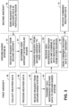
- FIG. 5 is a flowchart illustrating an example technique, performed by a first entity, for receiving weather data from a second entity. As discussed herein, the technique is described with respect to system 18 of FIG. 2 and is described such that aircraft 20 is the first entity. However, the technique may apply to other example systems as well.
- processor 26 of aircraft 20 determines a need for weather data for a region of interest over a particular time range (100).
- the time range may be, for example, a time range that would provide weather data relevant to the flight of aircraft 20 through the region of interest.
- Processor 26 may request the weather data from a second entity (102), which can be, for example, ground-based station 24 or another aircraft 22.
- processor 26 may determine that a particular aircraft is capable of providing the weather data corresponding to the region of interest and the relevant time range based on flight schedules including the other aircraft, a known position of the other aircraft, and ranges of sensors onboard the other aircraft, and transmit the request for weather data to the identified aircraft.
- the second entity Responsive to the request, the second entity sends the corresponding weather data to aircraft 20.
- Processor 26 receives the weather data from the second entity, wherein the weather data can be geo-referenced weather data (104).
- the geo-referenced weather data may include information identifying a location of the weather data and a time stamp of the weather data.
- the weather data is not geo-referenced or only a subset is geo-referenced.
- processor 26 of aircraft 20 only receives weather data from the second entity responsive to the processor of the first entity requesting the weather data.
- processor 26 combines the received geo-referenced weather data with a set of weather data determined from a source other than the second entity, such as weather data from ground-based system 24, satellite 4 ( FIG. 1 ) or ground-based instrumentation 6 ( FIG. 1 ).
- a computer-readable storage medium having stored thereon instructions. When executed, the instructions cause a processor of a first entity to determine a need for weather data for a location over a time range, request weather data corresponding to the location over the time range from a second entity, and receive the weather data from the second entity, wherein the weather data is geo-referenced weather data.
- a ground-based system may receive weather data from one or more sources, aggregate the weather data, and disseminate the weather data to one or more aircraft.
- the ground-based system may be a world-wide system that is capable of sending weather data from aircraft all over the world to other entities.
- techniques, devices, and systems described herein may save costs on communications, because only requested (e.g., needed) weather data would be exchanged between aircraft and ground-based systems.
- an aircraft can be configured to respond to polling for specific weather related data elements (either individually or by geographic region) for either textual or graphical information from the flight deck rather than just have the aircraft continuously push information, which is the current industry practice.
- the determination of which aircraft to request information from and which data links to use can be based on various conditions such as predicted or measured weather conditions in a region and planned routes of flights in a region to optimize the weather coverage at lowest communication cost.
- the techniques of this disclosure may be implemented in a wide variety of computer devices. Any components, modules or units have been described provided to emphasize functional aspects and does not necessarily require realization by different hardware units. The techniques described herein may also be implemented in hardware, software, firmware, or any combination thereof. Any features described as modules, units or components may be implemented together in an integrated logic device or separately as discrete but interoperable logic devices. In some cases, various features may be implemented as an integrated circuit device, such as an integrated circuit chip or chipset.
- the techniques may be realized at least in part by a computer-readable medium comprising instructions that, when executed by one or more processors, performs one or more of the methods described above.
- the one or more processors can be, for example, one or more digital signal processors (DSPs), general purpose microprocessors, application specific integrated circuits (ASICs), field programmable logic arrays (FPGAs), or other equivalent integrated or discrete logic circuitry.
- DSPs digital signal processors
- ASICs application specific integrated circuits
- FPGAs field programmable logic arrays
- the computer-readable medium may comprise a tangible computer-readable storage medium and may form part of a larger product.
- the computer-readable storage medium may comprise random access memory (RAM) such as synchronous dynamic random access memory (SDRAM), read-only memory (ROM), non-volatile random access memory (NVRAM), electrically erasable programmable read-only memory (EEPROM), FLASH memory, magnetic or optical data storage media, and the like.
- RAM random access memory
- ROM read-only memory
- NVRAM non-volatile random access memory
- EEPROM electrically erasable programmable read-only memory
- FLASH memory magnetic or optical data storage media, and the like.
- the computer-readable storage medium may also comprise a non-volatile storage device, such as a hard-disk, magnetic tape, a compact disk (CD), digital versatile disk (DVD), Blu-ray disk, holographic data storage media, or other non-volatile storage device.
- processor may refer to any of the foregoing structure or any other structure suitable for implementation of the techniques described herein.
- functionality described herein may be provided within dedicated software modules or hardware modules configured for performing the techniques of this disclosure. Even if implemented in software, the techniques may use hardware such as a processor to execute the software, and a memory to store the software. In any such cases, the computers described herein may define a specific machine that is capable of executing the specific functions described herein. Also, the techniques could be fully implemented in one or more circuits or logic elements, which could also be considered a processor.
Landscapes
- Engineering & Computer Science (AREA)
- Physics & Mathematics (AREA)
- General Physics & Mathematics (AREA)
- Radar, Positioning & Navigation (AREA)
- Remote Sensing (AREA)
- Aviation & Aerospace Engineering (AREA)
- Computer Networks & Wireless Communication (AREA)
- Electromagnetism (AREA)
- Environmental & Geological Engineering (AREA)
- Signal Processing (AREA)
- Life Sciences & Earth Sciences (AREA)
- Atmospheric Sciences (AREA)
- Biodiversity & Conservation Biology (AREA)
- Ecology (AREA)
- Environmental Sciences (AREA)
- Traffic Control Systems (AREA)
- Navigation (AREA)
- Measuring Pulse, Heart Rate, Blood Pressure Or Blood Flow (AREA)
- Financial Or Insurance-Related Operations Such As Payment And Settlement (AREA)
Claims (9)
- Verfahren, das Folgendes umfasst:Anfordern von Wetterdaten, die einer Region von Interesse entsprechen, von einer zweiten Einheit (20) durch einen Prozessor einer ersten Einheit (24);Empfangen der Wetterdaten von der zweiten Einheit (20) durch den Prozessor (46) der ersten Einheit (24), wobei die zweite Einheit (20) die Wetterdaten nur als Reaktion auf das Empfangen einer Anforderung der Wetterdaten von der ersten Einheit (24) an die erste Einheit (24) überträgt,wobei die erste Einheit (24) eine Bodenstation, ein erstes Flugzeug oder ein anderes Fahrzeug umfasst,wobei die zweite Einheit (20) ein zweites Flugzeug umfasst, undwobei das Verfahren ferner Folgendes umfasst:Empfangen einer Anforderung der Wetterdaten für die Region von Interesse durch den Prozessor der ersten Einheit (24) und von einer dritten Einheit (22), die ein luftgestütztes System, ein bodengestütztes System oder ein wassergestütztes System umfasst; undÜbertragen der von der zweiten Einheit (20) empfangenen Wetterdaten an die dritte Einheit (22) durch den Prozessor der ersten Einheit (24) als Reaktion auf die Anfrage von der dritten Einheit (22),dadurch gekennzeichnet, dassder Prozessor ferner konfiguriert ist, um die von der zweiten Einheit (20) empfangenen Wetterdaten mit Wetterdaten zu kombinieren, die von einer anderen Quelle als der zweiten Einheit (20) bestimmt wurden, und die kombinierten Wetterdaten an die dritte Einheit (22) zu übertragen.
- Verfahren nach Anspruch 1, wobei die erste Einheit ein System an Bord des ersten Flugzeugs umfasst.
- Verfahren nach Anspruch 1, das ferner umfasst, dass vor der Anforderung der Wetterdaten von der zweiten Einheit durch den Prozessor der ersten Einheit bestimmt wird, dass die zweite Einheit fähig ist, Wetterdaten zu erhalten, die der Region von Interesse entsprechen.
- Verfahren nach Anspruch 1, das ferner Folgendes umfasst:Bestimmen der Region von Interesse basierend auf einem Flugplan der dritten Einheit; undErkennen eines Flugzeugs, das die Wetterdaten, die der Region von Interesse entsprechen, bereitstellen kann, als das zweite Flugzeug, bevor die Wetterdaten für die bestimmte Region von Interesse von der zweiten Einheit angefordert werden.
- Verfahren nach Anspruch 1, das ferner das Senden der Wetterdaten durch den Prozessor der ersten Einheit an eine oder mehrere zusätzliche Einheiten umfasst, die ein Abonnement für das Empfangen von Wetterdaten aufweisen.
- System, das Folgendes umfasst:ein Kommunikationssystem (18); undeinen Prozessor (46) einer ersten Einheit (24), der konfiguriert ist, um:über das Kommunikationssystem eine Anforderung von Wetterdaten, die einer Region von Interesse entsprechen, von einer zweiten Einheit (20) zu übertragen;über das Kommunikationssystem die Wetterdaten von der zweiten Einheit (20) zu empfangen, wobei die zweite Einheit (20) die Wetterdaten nur als Reaktion auf das Empfangen einer Anforderung der Wetterdaten von der ersten Einheit (24) an die erste Einheit (24) überträgt,wobei die erste Einheit (24) eine Bodenstation, ein erstes Flugzeug oder ein anderes Fahrzeug umfasst,wobei die zweite Einheit (20) ein zweites Flugzeug umfasst, undwobei der Prozessor (46) ferner konfiguriert ist, um:eine Anforderung der Wetterdaten für die Region von Interesse über das Kommunikationssystem und von einer dritten Einheit (22), die ein luftgestütztes System, ein bodengestütztes System oder ein wassergestütztes System umfasst, zu empfangen; unddie von der zweiten Einheit (20) empfangenen Wetterdaten über das Kommunikationssystem an die dritte Einheit (22) zu übertragen,dadurch gekennzeichnet, dassder Prozessor ferner konfiguriert ist, um die von der zweiten Einheit (20) empfangenen Wetterdaten mit Wetterdaten zu kombinieren, die von einer anderen Quelle als der zweiten Einheit (20) bestimmt wurden, und die kombinierten Wetterdaten an die dritte Einheit (22) zu übertragen.
- System nach Anspruch 6, wobei der Prozessor ferner konfiguriert ist, um vor dem Anfordern der Wetterdaten von der zweiten Einheit zu bestimmen, dass die zweite Einheit fähig ist, Wetterdaten zu erhalten, die der Region von Interesse entsprechen.
- System nach Anspruch 6, wobei das anfordernde System ein bodengestütztes System ist, wobei der Prozessor ferner konfiguriert ist, um:die zweite Einheit als fähig zu erkennen, Wetterdaten für die Region von Interesse zu erhalten,zu bestimmen, dass ein oder mehrere andere Flugzeuge die Region von Interesse anfliegen werden, unddie von der zweiten Einheit empfangenen Wetterdaten als Reaktion auf das Bestimmen, dass das eine oder die mehreren anderen Flugzeuge die Region von Interesse anfliegen werden, an das eine oder die mehreren anderen Flugzeuge zu übertragen.
- System nach Anspruch 6, wobei der Prozessor ferner konfiguriert ist, um:die Region von Interesse basierend auf einem Flugplan der dritten Einheit zu bestimmen; undein Flugzeug, das die Wetterdaten für die bestimmte Region von Interesse bereitstellen kann, als das zweite Flugzeug zu erkennen, bevor die Wetterdaten, die der Region von Interesse entsprechen, von der zweiten Einheit angefordert werden.
Applications Claiming Priority (1)
| Application Number | Priority Date | Filing Date | Title |
|---|---|---|---|
| US14/254,317 US9967707B2 (en) | 2014-04-16 | 2014-04-16 | Weather data dissemination |
Publications (3)
| Publication Number | Publication Date |
|---|---|
| EP2933663A2 EP2933663A2 (de) | 2015-10-21 |
| EP2933663A3 EP2933663A3 (de) | 2015-11-11 |
| EP2933663B1 true EP2933663B1 (de) | 2024-07-17 |
Family
ID=52824066
Family Applications (1)
| Application Number | Title | Priority Date | Filing Date |
|---|---|---|---|
| EP15162280.0A Active EP2933663B1 (de) | 2014-04-16 | 2015-04-01 | Wetterdatenverbreitung |
Country Status (2)
| Country | Link |
|---|---|
| US (1) | US9967707B2 (de) |
| EP (1) | EP2933663B1 (de) |
Families Citing this family (43)
| Publication number | Priority date | Publication date | Assignee | Title |
|---|---|---|---|---|
| US10388169B2 (en) * | 2014-07-17 | 2019-08-20 | Airbus Group India Private Limited | System and method for providing in-flight weather information to compute an optimized vertical flight profile |
| US9691288B2 (en) * | 2014-07-17 | 2017-06-27 | Airbus Group India Private Limited | System and method for sending in-flight weather alerts |
| US20160027313A1 (en) * | 2014-07-22 | 2016-01-28 | Sikorsky Aircraft Corporation | Environmentally-aware landing zone classification |
| US10181895B2 (en) * | 2014-09-04 | 2019-01-15 | Honeywell International Inc. | Free space laser and millimetre wave(MMW) network for airborne relay networks |
| US10935693B2 (en) * | 2015-03-18 | 2021-03-02 | Honeywell International Inc. | Prediction of ice crystal presence in a volume of airspace |
| US11157476B2 (en) * | 2015-04-15 | 2021-10-26 | Honeywell International Inc. | Marine weather radar and sea state data aggregating system |
| US9952310B2 (en) * | 2015-08-07 | 2018-04-24 | Honeywell International Inc. | Aircraft weather radar coverage supplementing system |
| US10175353B2 (en) * | 2015-09-23 | 2019-01-08 | Rockwell Collins, Inc. | Enhancement of airborne weather radar performance using external weather data |
| WO2017123768A1 (en) * | 2016-01-12 | 2017-07-20 | Planck Aerosystems, Inc. | Methods and apparatus for unmanned aircraft-based object detection |
| US10700767B2 (en) | 2016-03-16 | 2020-06-30 | Honeywell International Inc. | Requesting weather data based on pre-selected events |
| US10539654B1 (en) * | 2016-04-29 | 2020-01-21 | Rockwell Collins, Inc. | Method and apparatus for providing weather and other hazard information to aircraft inflight |
| US9584237B1 (en) * | 2016-05-06 | 2017-02-28 | Here Global B.V. | Method, apparatus, and computer program product for selecting weather stations |
| US10311740B2 (en) * | 2016-06-27 | 2019-06-04 | Honeywell International Inc. | Aggregation and distribution of real-time data |
| US10151834B2 (en) | 2016-07-26 | 2018-12-11 | Honeywell International Inc. | Weather data de-conflicting and correction system |
| US10431014B2 (en) * | 2016-08-18 | 2019-10-01 | Honeywell International Inc. | Data recording function |
| JP6692262B2 (ja) * | 2016-09-01 | 2020-05-13 | アイシン・エィ・ダブリュ株式会社 | 経路探索システムおよび経路探索プログラム |
| CN106370231B (zh) * | 2016-09-19 | 2018-10-09 | 中国气象局气象探测中心 | 一种地面气象观测站气象探测环境调查评估方法及系统 |
| US10482776B2 (en) | 2016-09-26 | 2019-11-19 | Sikorsky Aircraft Corporation | Landing zone evaluation and rating sharing among multiple users |
| US10215840B2 (en) * | 2016-09-27 | 2019-02-26 | Honeywell International Inc. | Thresholds for transmitting weather data |
| US11704344B2 (en) * | 2016-10-25 | 2023-07-18 | Here Global B.V. | Method and apparatus for determining weather-related information on a tile basis |
| US10285087B2 (en) | 2016-11-10 | 2019-05-07 | Honeywell International Inc. | Efficient event-triggered reporting system |
| US10761207B2 (en) * | 2016-12-16 | 2020-09-01 | Honeywell International Inc. | Automatic uplink weather information sharing |
| US20180247548A1 (en) * | 2017-02-27 | 2018-08-30 | Honeywell International Inc. | System and method to decipher and display advisory information |
| US10147326B2 (en) | 2017-02-27 | 2018-12-04 | Honeywell International Inc. | Systems and methods of gathering and distributing critical weather event information |
| WO2018236903A1 (en) | 2017-06-20 | 2018-12-27 | Planck Aerosystems Inc. | SYSTEMS AND METHODS FOR RECHARGING A PILOT-FREE AIR VEHICLE ON A MOBILE PLATFORM |
| US20190049578A1 (en) * | 2017-08-09 | 2019-02-14 | Honeywell International Inc. | Apparatus and method for supplementing sensor data |
| WO2019038759A1 (en) * | 2017-08-21 | 2019-02-28 | Rail Vision Ltd | SYSTEM AND METHOD FOR MULTIPLE AND DYNAMIC METEOROLOGICAL DATA SOURCES |
| US10116378B1 (en) * | 2017-09-20 | 2018-10-30 | Honeywell International Inc. | Systems and method of automatically generated radio calls |
| US10955549B2 (en) | 2017-10-12 | 2021-03-23 | Honeywell International Inc. | Melting layer estimation by weather radar device |
| US10877150B2 (en) | 2018-03-06 | 2020-12-29 | Honeywell International Inc. | Ice crystal detection by weather radar |
| FR3079497B1 (fr) * | 2018-03-30 | 2020-08-14 | Airbus Operations Sas | Detection de conditions givrantes pour un aeronef par analyse de consommation de courant electrique |
| US12084179B2 (en) | 2018-05-23 | 2024-09-10 | Aerovironment, Inc. | System and method for drone tethering |
| WO2020209915A2 (en) | 2019-01-15 | 2020-10-15 | Planck Aerosystems Inc. | Systems and methods for delivery using unmanned aerial vehicles |
| WO2020251643A1 (en) * | 2019-03-18 | 2020-12-17 | Daniel Baumgartner | Drone-assisted systems and methods of calculating a ballistic solution for a projectile |
| FR3095277B1 (fr) * | 2019-04-19 | 2021-06-04 | Thales Sa | Registres distribues pour la gestion de donnees meteorologiques en aeronautique |
| US20210094703A1 (en) * | 2019-05-30 | 2021-04-01 | Launch On Demand Corporation | Launch on demand |
| US11630203B2 (en) * | 2019-06-25 | 2023-04-18 | Raytheon Company | Ground station sensing of weather around an aircraft |
| US11567193B2 (en) | 2020-04-17 | 2023-01-31 | Honeywell International Inc. | Retrieving weather data from memory |
| US11482123B2 (en) * | 2020-08-24 | 2022-10-25 | Rockwell Collins, Inc. | Sensor enhanced real time automatic pilot report (PIREP) generation |
| WO2022250860A1 (en) * | 2021-05-28 | 2022-12-01 | Skygrid, Llc | Increasing awareness of an environmental condition for an unmanned aerial vehicle |
| US12488693B2 (en) * | 2022-11-16 | 2025-12-02 | Arinc Incorporated | Method to regenerate on board weather radar display at the ground |
| EP4372724A1 (de) * | 2022-11-16 | 2024-05-22 | Arinc Incorporated | Verfahren zur regeneration einer bordeigenen wetterradaranzeige am boden |
| US12374230B2 (en) | 2023-05-01 | 2025-07-29 | Rockwell Collins, Inc. | Aerospace antenna and network system for simultaneously delivering internet to aircraft and reporting air quality index parameters |
Citations (1)
| Publication number | Priority date | Publication date | Assignee | Title |
|---|---|---|---|---|
| EP2157453A2 (de) * | 2008-08-18 | 2010-02-24 | Honeywell International Inc. | Verfahren zur Erzeugung einer umfassenden Luftraum-Wetterbedingungsanzeige aus gemeinsamen Flugzeugsensordaten |
Family Cites Families (57)
| Publication number | Priority date | Publication date | Assignee | Title |
|---|---|---|---|---|
| US5265024A (en) | 1991-04-05 | 1993-11-23 | Vigyan, Inc. | Pilots automated weather support system |
| US5657009A (en) | 1991-10-31 | 1997-08-12 | Gordon; Andrew A. | System for detecting and viewing aircraft-hazardous incidents that may be encountered by aircraft landing or taking-off |
| FR2703537B1 (fr) | 1993-04-02 | 1995-06-09 | Sextant Avionique | Procédé pour la transmission d'informations par voie hertzienne. |
| US6720920B2 (en) | 1997-10-22 | 2004-04-13 | Intelligent Technologies International Inc. | Method and arrangement for communicating between vehicles |
| US6014606A (en) | 1996-10-07 | 2000-01-11 | Mcdonnell Douglas Corporation | Cockpit weather information system |
| US6043756A (en) | 1998-02-09 | 2000-03-28 | Alliedsignal Inc. | Aircraft weather information system |
| US6501392B2 (en) | 1998-02-09 | 2002-12-31 | Honeywell International Inc. | Aircraft weather information system |
| US6828922B1 (en) | 1998-02-09 | 2004-12-07 | Honeywell International Inc. | Synthetic airborne hazard display |
| AU5441099A (en) | 1998-08-31 | 2000-03-21 | Nowcasting International Limited | A meteorological and hydrographical forecast system and method |
| US6466976B1 (en) | 1998-12-03 | 2002-10-15 | Nortel Networks Limited | System and method for providing desired service policies to subscribers accessing the internet |
| US6536272B1 (en) | 1999-08-06 | 2003-03-25 | University Of Miami | Water monitoring, data collection, and transmission module |
| US6721559B1 (en) | 2000-02-29 | 2004-04-13 | Northrop Grumman Corporation | Integrated communications management unit and very high frequency data radio |
| US6441773B1 (en) | 2000-08-24 | 2002-08-27 | Rockwell Collins, Inc. | Weather radar system integrating ground-based weather radar with on-board aircraft weather radar |
| US6448922B1 (en) | 2000-08-24 | 2002-09-10 | Rockwell Collins, Inc. | Retrofit solution for the integration of ground-based weather radar images with on-board weather radar |
| US20040244476A1 (en) | 2003-06-05 | 2004-12-09 | International Business Machines Corporation | System and method to update weather forecasting using on-board sensing equipment |
| US8203480B1 (en) | 2003-07-31 | 2012-06-19 | Rockwell Collins, Inc. | Predictive and adaptive weather radar detection system and method |
| US7047114B1 (en) | 2003-10-23 | 2006-05-16 | Charles David Rogers | System and apparatus for automatic and continuous monitoring, proactive warning and control of one or more independently operated vessels |
| ATE477510T1 (de) | 2004-02-20 | 2010-08-15 | Harman Becker Automotive Sys | Vorrichtung und verfahren zum erzeugen von umgebungsparametern und zum bestimmen von wetterinformationen |
| US7069147B2 (en) | 2004-05-28 | 2006-06-27 | Honeywell International Inc. | Airborne based monitoring |
| US7084775B1 (en) | 2004-07-12 | 2006-08-01 | User-Centric Ip, L.P. | Method and system for generating and sending user-centric weather alerts |
| US6977608B1 (en) | 2004-12-15 | 2005-12-20 | Rockwell Collins | Atmospheric data aggregation and forecasting system |
| US7633428B1 (en) | 2004-12-15 | 2009-12-15 | Rockwell Collins, Inc. | Weather data aggregation and display system for airborne network of member aircraft |
| US7365673B2 (en) | 2004-12-30 | 2008-04-29 | Honeywell International, Inc. | Compression and transmission of weather data |
| CH699530B1 (de) | 2005-03-07 | 2010-03-31 | Klaus Kuhlgatz | Anlage und Verfahren für das gesamtheitliche Bewirtschaften von Schiffen. |
| US7365675B2 (en) | 2005-09-26 | 2008-04-29 | The Boeing Company | Measuring wind vectors remotely using airborne radar |
| US20080035784A1 (en) * | 2006-08-10 | 2008-02-14 | Meserole Jere S | Aircraft wake vortex predictor and visualizer |
| GB2441802A (en) | 2006-09-13 | 2008-03-19 | Marine & Remote Sensing Soluti | Safety system for a vehicle |
| AU2008275570B2 (en) | 2007-04-13 | 2011-09-29 | Allen F. Labbe | System and method for dynamic data mining and distribution of maritime data |
| US8209071B2 (en) | 2007-04-16 | 2012-06-26 | Raytheon Company | Methods and apparatus for aircraft turbulence detection |
| US7633430B1 (en) | 2007-09-14 | 2009-12-15 | Rockwell Collins, Inc. | Terrain awareness system with false alert suppression |
| US7817078B2 (en) | 2008-02-29 | 2010-10-19 | Honeywell International Inc. | Systems and methods for supplemental weather information presentation on a display |
| US20100332056A1 (en) | 2008-08-18 | 2010-12-30 | Honeywell International Inc. | Systems and methods for generation of comprehensive airspace weather condition display from shared aircraft sensor data by a receiving aircraft |
| US8217828B2 (en) | 2008-08-18 | 2012-07-10 | Honeywell International Inc. | Systems and methods for generation of comprehensive airspace weather condition display from shared aircraft sensor data by a transmitting aircraft |
| US8130121B2 (en) | 2008-08-20 | 2012-03-06 | The Boeing Company | Automated turbulence display system |
| EP2356496A4 (de) | 2008-11-13 | 2015-05-27 | Univ Saint Louis | Vorrichtung und verfahren zur bereitstellung von umgebungsvorhersageindikatoren für notfallreaktionsmanager |
| JP5497410B2 (ja) | 2008-11-14 | 2014-05-21 | 三井化学株式会社 | 発泡体およびその製造方法 |
| US8144048B2 (en) | 2009-03-25 | 2012-03-27 | Honeywell International Inc. | Systems and methods for gaussian decomposition of weather radar data for communication |
| US8085182B2 (en) | 2009-03-31 | 2011-12-27 | Honeywell International Inc. | Systems and methods for collecting weather information using an airborne aircraft |
| US8223062B2 (en) | 2009-05-27 | 2012-07-17 | Honeywell International Inc. | Systems and methods for aircraft to aircraft exchange of radar information over low bandwidth communication channels |
| US8022859B2 (en) | 2009-06-02 | 2011-09-20 | Honeywell International Inc. | Systems and methods for using nexrad information to verify weather radar information |
| KR100934234B1 (ko) | 2009-08-13 | 2009-12-28 | (주)비엔티솔루션 | 웹 3d를 이용한 해양정보 제공시스템 및 그 방법 |
| US8165790B2 (en) | 2009-08-26 | 2012-04-24 | The Boeing Company | Dynamic weather selection |
| US8054214B2 (en) | 2009-09-30 | 2011-11-08 | Honeywell International Inc. | Systems and methods for preparing ground-based weather radar information for use in an installation vehicle |
| US8458600B2 (en) * | 2009-12-31 | 2013-06-04 | International Business Machines Corporation | Distributed multi-user mashup session |
| US8831795B2 (en) | 2010-04-12 | 2014-09-09 | Flight Focus Pte. Ltd. | Data synchronisation for a flight information system |
| FR2962867B1 (fr) | 2010-07-13 | 2012-08-17 | Thales Sa | Systeme permettant d'augmenter la couverture, l'information et la robustesse des dispositifs d'identification automatique de navires. |
| US8629788B1 (en) | 2010-08-10 | 2014-01-14 | Rockwell Collins, Inc. | Sensing, display, and dissemination of detected turbulence |
| US8604963B1 (en) | 2010-09-28 | 2013-12-10 | Rockwell Collins, Inc. | Radar system and method |
| US9223020B1 (en) * | 2010-09-28 | 2015-12-29 | Rockwell Collins, Inc. | System and method for weather detection using more than one source of radar data |
| US8314730B1 (en) | 2010-12-14 | 2012-11-20 | The Boeing Company | Collection of meteorological data by vehicles |
| WO2013028157A1 (en) | 2011-08-19 | 2013-02-28 | Cornell University | System and methods for remote monitoring |
| EP2575120A3 (de) | 2011-09-30 | 2014-01-22 | The Boeing Company | Systeme und Verfahren zum Verarbeiten von Fluginformation |
| US9256004B2 (en) | 2012-04-10 | 2016-02-09 | Honeywell International Inc. | System and method for transmitting differential weather information to an in-flight aircraft |
| US9998556B2 (en) | 2013-09-11 | 2018-06-12 | Oath Inc. | Unified end user notification platform |
| CN103512562A (zh) | 2013-09-24 | 2014-01-15 | 上海海洋大学 | 基于Arduino的近岸海域环境自动监测及预警系统 |
| US9535158B1 (en) | 2013-11-21 | 2017-01-03 | Rockwell Collins, Inc. | Weather radar system and method with fusion of multiple weather information sources |
| US10305736B2 (en) | 2014-12-18 | 2019-05-28 | Telefonaktiebolaget Lm Ericsson (Publ) | Methods, network nodes, and computer program products for price signal feedback for network optimization |
-
2014
- 2014-04-16 US US14/254,317 patent/US9967707B2/en active Active
-
2015
- 2015-04-01 EP EP15162280.0A patent/EP2933663B1/de active Active
Patent Citations (1)
| Publication number | Priority date | Publication date | Assignee | Title |
|---|---|---|---|---|
| EP2157453A2 (de) * | 2008-08-18 | 2010-02-24 | Honeywell International Inc. | Verfahren zur Erzeugung einer umfassenden Luftraum-Wetterbedingungsanzeige aus gemeinsamen Flugzeugsensordaten |
Also Published As
| Publication number | Publication date |
|---|---|
| EP2933663A3 (de) | 2015-11-11 |
| EP2933663A2 (de) | 2015-10-21 |
| US9967707B2 (en) | 2018-05-08 |
| US20150304813A1 (en) | 2015-10-22 |
Similar Documents
| Publication | Publication Date | Title |
|---|---|---|
| EP2933663B1 (de) | Wetterdatenverbreitung | |
| US11588543B2 (en) | Requesting weather data based on pre-selected events | |
| CN106546984B (zh) | 气象雷达控制系统和使用该系统的方法 | |
| EP2937714B1 (de) | Bordwetterradar-flugstrategiesystem mit bandbreitenverwaltung | |
| US9869766B1 (en) | Enhancement of airborne weather radar performance using external weather data | |
| US20260018066A1 (en) | Airborne drone alerting system | |
| US8022859B2 (en) | Systems and methods for using nexrad information to verify weather radar information | |
| US8903571B2 (en) | Systems and methods for generation of comprehensive airspace weather condition display from shared aircraft sensor data | |
| US8217828B2 (en) | Systems and methods for generation of comprehensive airspace weather condition display from shared aircraft sensor data by a transmitting aircraft | |
| JP4651679B2 (ja) | 乱気流を遠隔的に測定するシステム | |
| US8314730B1 (en) | Collection of meteorological data by vehicles | |
| US20100332056A1 (en) | Systems and methods for generation of comprehensive airspace weather condition display from shared aircraft sensor data by a receiving aircraft | |
| EP2975595B1 (de) | Abstandsberechnung auf basis eines skalaren produkts | |
| US9126696B1 (en) | Method and system for obtaining and presenting turbulence data via communication devices located on airplanes | |
| CN104133256A (zh) | 在透视视图中图形显示天气灾害的系统和方法 | |
| US12488693B2 (en) | Method to regenerate on board weather radar display at the ground | |
| US20190182326A1 (en) | Vehicle defined source transmitter | |
| EP3441786A1 (de) | Vorrichtung und verfahren zur ergänzung von sensordaten | |
| US20240369702A1 (en) | Method for a compact representation of airborne weather data for exchange and storage | |
| EP4372724A1 (de) | Verfahren zur regeneration einer bordeigenen wetterradaranzeige am boden | |
| US20240284237A1 (en) | Method for smart air/ground data transmission optimization | |
| EP4459311A1 (de) | Verfahren zur kompakten darstellung von flugwetterdaten für austausch und speicherung |
Legal Events
| Date | Code | Title | Description |
|---|---|---|---|
| PUAL | Search report despatched |
Free format text: ORIGINAL CODE: 0009013 |
|
| PUAI | Public reference made under article 153(3) epc to a published international application that has entered the european phase |
Free format text: ORIGINAL CODE: 0009012 |
|
| 17P | Request for examination filed |
Effective date: 20150401 |
|
| AK | Designated contracting states |
Kind code of ref document: A2 Designated state(s): AL AT BE BG CH CY CZ DE DK EE ES FI FR GB GR HR HU IE IS IT LI LT LU LV MC MK MT NL NO PL PT RO RS SE SI SK SM TR |
|
| AX | Request for extension of the european patent |
Extension state: BA ME |
|
| AK | Designated contracting states |
Kind code of ref document: A3 Designated state(s): AL AT BE BG CH CY CZ DE DK EE ES FI FR GB GR HR HU IE IS IT LI LT LU LV MC MK MT NL NO PL PT RO RS SE SI SK SM TR |
|
| AX | Request for extension of the european patent |
Extension state: BA ME |
|
| RIC1 | Information provided on ipc code assigned before grant |
Ipc: G01W 1/08 20060101AFI20151005BHEP |
|
| RAP1 | Party data changed (applicant data changed or rights of an application transferred) |
Owner name: HONEYWELL INTERNATIONAL INC. |
|
| STAA | Information on the status of an ep patent application or granted ep patent |
Free format text: STATUS: EXAMINATION IS IN PROGRESS |
|
| 17Q | First examination report despatched |
Effective date: 20180718 |
|
| RIC1 | Information provided on ipc code assigned before grant |
Ipc: H04W 4/02 20180101ALI20190926BHEP Ipc: G01S 13/95 20060101ALI20190926BHEP Ipc: G01W 1/08 20060101AFI20190926BHEP Ipc: G08G 5/00 20060101ALI20190926BHEP Ipc: G01S 7/00 20060101ALI20190926BHEP |
|
| P01 | Opt-out of the competence of the unified patent court (upc) registered |
Effective date: 20230421 |
|
| GRAP | Despatch of communication of intention to grant a patent |
Free format text: ORIGINAL CODE: EPIDOSNIGR1 |
|
| STAA | Information on the status of an ep patent application or granted ep patent |
Free format text: STATUS: GRANT OF PATENT IS INTENDED |
|
| INTG | Intention to grant announced |
Effective date: 20240306 |
|
| GRAS | Grant fee paid |
Free format text: ORIGINAL CODE: EPIDOSNIGR3 |
|
| GRAA | (expected) grant |
Free format text: ORIGINAL CODE: 0009210 |
|
| STAA | Information on the status of an ep patent application or granted ep patent |
Free format text: STATUS: THE PATENT HAS BEEN GRANTED |
|
| AK | Designated contracting states |
Kind code of ref document: B1 Designated state(s): AL AT BE BG CH CY CZ DE DK EE ES FI FR GB GR HR HU IE IS IT LI LT LU LV MC MK MT NL NO PL PT RO RS SE SI SK SM TR |
|
| REG | Reference to a national code |
Ref country code: GB Ref legal event code: FG4D |
|
| REG | Reference to a national code |
Ref country code: CH Ref legal event code: EP |
|
| REG | Reference to a national code |
Ref country code: DE Ref legal event code: R096 Ref document number: 602015089217 Country of ref document: DE |
|
| REG | Reference to a national code |
Ref country code: IE Ref legal event code: FG4D |
|
| REG | Reference to a national code |
Ref country code: LT Ref legal event code: MG9D |
|
| REG | Reference to a national code |
Ref country code: NL Ref legal event code: MP Effective date: 20240717 |
|
| PG25 | Lapsed in a contracting state [announced via postgrant information from national office to epo] |
Ref country code: PT Free format text: LAPSE BECAUSE OF FAILURE TO SUBMIT A TRANSLATION OF THE DESCRIPTION OR TO PAY THE FEE WITHIN THE PRESCRIBED TIME-LIMIT Effective date: 20241118 |
|
| REG | Reference to a national code |
Ref country code: AT Ref legal event code: MK05 Ref document number: 1704662 Country of ref document: AT Kind code of ref document: T Effective date: 20240717 |
|
| PG25 | Lapsed in a contracting state [announced via postgrant information from national office to epo] |
Ref country code: NL Free format text: LAPSE BECAUSE OF FAILURE TO SUBMIT A TRANSLATION OF THE DESCRIPTION OR TO PAY THE FEE WITHIN THE PRESCRIBED TIME-LIMIT Effective date: 20240717 |
|
| PG25 | Lapsed in a contracting state [announced via postgrant information from national office to epo] |
Ref country code: PT Free format text: LAPSE BECAUSE OF FAILURE TO SUBMIT A TRANSLATION OF THE DESCRIPTION OR TO PAY THE FEE WITHIN THE PRESCRIBED TIME-LIMIT Effective date: 20241118 Ref country code: NL Free format text: LAPSE BECAUSE OF FAILURE TO SUBMIT A TRANSLATION OF THE DESCRIPTION OR TO PAY THE FEE WITHIN THE PRESCRIBED TIME-LIMIT Effective date: 20240717 |
|
| PG25 | Lapsed in a contracting state [announced via postgrant information from national office to epo] |
Ref country code: NO Free format text: LAPSE BECAUSE OF FAILURE TO SUBMIT A TRANSLATION OF THE DESCRIPTION OR TO PAY THE FEE WITHIN THE PRESCRIBED TIME-LIMIT Effective date: 20241017 |
|
| PG25 | Lapsed in a contracting state [announced via postgrant information from national office to epo] |
Ref country code: FI Free format text: LAPSE BECAUSE OF FAILURE TO SUBMIT A TRANSLATION OF THE DESCRIPTION OR TO PAY THE FEE WITHIN THE PRESCRIBED TIME-LIMIT Effective date: 20240717 Ref country code: PL Free format text: LAPSE BECAUSE OF FAILURE TO SUBMIT A TRANSLATION OF THE DESCRIPTION OR TO PAY THE FEE WITHIN THE PRESCRIBED TIME-LIMIT Effective date: 20240717 Ref country code: GR Free format text: LAPSE BECAUSE OF FAILURE TO SUBMIT A TRANSLATION OF THE DESCRIPTION OR TO PAY THE FEE WITHIN THE PRESCRIBED TIME-LIMIT Effective date: 20241018 |
|
| PG25 | Lapsed in a contracting state [announced via postgrant information from national office to epo] |
Ref country code: BG Free format text: LAPSE BECAUSE OF FAILURE TO SUBMIT A TRANSLATION OF THE DESCRIPTION OR TO PAY THE FEE WITHIN THE PRESCRIBED TIME-LIMIT Effective date: 20240717 |
|
| PG25 | Lapsed in a contracting state [announced via postgrant information from national office to epo] |
Ref country code: LV Free format text: LAPSE BECAUSE OF FAILURE TO SUBMIT A TRANSLATION OF THE DESCRIPTION OR TO PAY THE FEE WITHIN THE PRESCRIBED TIME-LIMIT Effective date: 20240717 |
|
| PG25 | Lapsed in a contracting state [announced via postgrant information from national office to epo] |
Ref country code: AT Free format text: LAPSE BECAUSE OF FAILURE TO SUBMIT A TRANSLATION OF THE DESCRIPTION OR TO PAY THE FEE WITHIN THE PRESCRIBED TIME-LIMIT Effective date: 20240717 Ref country code: IS Free format text: LAPSE BECAUSE OF FAILURE TO SUBMIT A TRANSLATION OF THE DESCRIPTION OR TO PAY THE FEE WITHIN THE PRESCRIBED TIME-LIMIT Effective date: 20241117 |
|
| PG25 | Lapsed in a contracting state [announced via postgrant information from national office to epo] |
Ref country code: HR Free format text: LAPSE BECAUSE OF FAILURE TO SUBMIT A TRANSLATION OF THE DESCRIPTION OR TO PAY THE FEE WITHIN THE PRESCRIBED TIME-LIMIT Effective date: 20240717 |
|
| PG25 | Lapsed in a contracting state [announced via postgrant information from national office to epo] |
Ref country code: RS Free format text: LAPSE BECAUSE OF FAILURE TO SUBMIT A TRANSLATION OF THE DESCRIPTION OR TO PAY THE FEE WITHIN THE PRESCRIBED TIME-LIMIT Effective date: 20241017 Ref country code: ES Free format text: LAPSE BECAUSE OF FAILURE TO SUBMIT A TRANSLATION OF THE DESCRIPTION OR TO PAY THE FEE WITHIN THE PRESCRIBED TIME-LIMIT Effective date: 20240717 |
|
| PG25 | Lapsed in a contracting state [announced via postgrant information from national office to epo] |
Ref country code: RS Free format text: LAPSE BECAUSE OF FAILURE TO SUBMIT A TRANSLATION OF THE DESCRIPTION OR TO PAY THE FEE WITHIN THE PRESCRIBED TIME-LIMIT Effective date: 20241017 Ref country code: PL Free format text: LAPSE BECAUSE OF FAILURE TO SUBMIT A TRANSLATION OF THE DESCRIPTION OR TO PAY THE FEE WITHIN THE PRESCRIBED TIME-LIMIT Effective date: 20240717 Ref country code: NO Free format text: LAPSE BECAUSE OF FAILURE TO SUBMIT A TRANSLATION OF THE DESCRIPTION OR TO PAY THE FEE WITHIN THE PRESCRIBED TIME-LIMIT Effective date: 20241017 Ref country code: LV Free format text: LAPSE BECAUSE OF FAILURE TO SUBMIT A TRANSLATION OF THE DESCRIPTION OR TO PAY THE FEE WITHIN THE PRESCRIBED TIME-LIMIT Effective date: 20240717 Ref country code: IS Free format text: LAPSE BECAUSE OF FAILURE TO SUBMIT A TRANSLATION OF THE DESCRIPTION OR TO PAY THE FEE WITHIN THE PRESCRIBED TIME-LIMIT Effective date: 20241117 Ref country code: HR Free format text: LAPSE BECAUSE OF FAILURE TO SUBMIT A TRANSLATION OF THE DESCRIPTION OR TO PAY THE FEE WITHIN THE PRESCRIBED TIME-LIMIT Effective date: 20240717 Ref country code: GR Free format text: LAPSE BECAUSE OF FAILURE TO SUBMIT A TRANSLATION OF THE DESCRIPTION OR TO PAY THE FEE WITHIN THE PRESCRIBED TIME-LIMIT Effective date: 20241018 Ref country code: FI Free format text: LAPSE BECAUSE OF FAILURE TO SUBMIT A TRANSLATION OF THE DESCRIPTION OR TO PAY THE FEE WITHIN THE PRESCRIBED TIME-LIMIT Effective date: 20240717 Ref country code: ES Free format text: LAPSE BECAUSE OF FAILURE TO SUBMIT A TRANSLATION OF THE DESCRIPTION OR TO PAY THE FEE WITHIN THE PRESCRIBED TIME-LIMIT Effective date: 20240717 Ref country code: BG Free format text: LAPSE BECAUSE OF FAILURE TO SUBMIT A TRANSLATION OF THE DESCRIPTION OR TO PAY THE FEE WITHIN THE PRESCRIBED TIME-LIMIT Effective date: 20240717 Ref country code: AT Free format text: LAPSE BECAUSE OF FAILURE TO SUBMIT A TRANSLATION OF THE DESCRIPTION OR TO PAY THE FEE WITHIN THE PRESCRIBED TIME-LIMIT Effective date: 20240717 |
|
| PG25 | Lapsed in a contracting state [announced via postgrant information from national office to epo] |
Ref country code: RO Free format text: LAPSE BECAUSE OF FAILURE TO SUBMIT A TRANSLATION OF THE DESCRIPTION OR TO PAY THE FEE WITHIN THE PRESCRIBED TIME-LIMIT Effective date: 20240717 Ref country code: DK Free format text: LAPSE BECAUSE OF FAILURE TO SUBMIT A TRANSLATION OF THE DESCRIPTION OR TO PAY THE FEE WITHIN THE PRESCRIBED TIME-LIMIT Effective date: 20240717 Ref country code: SM Free format text: LAPSE BECAUSE OF FAILURE TO SUBMIT A TRANSLATION OF THE DESCRIPTION OR TO PAY THE FEE WITHIN THE PRESCRIBED TIME-LIMIT Effective date: 20240717 |
|
| REG | Reference to a national code |
Ref country code: DE Ref legal event code: R097 Ref document number: 602015089217 Country of ref document: DE |
|
| PG25 | Lapsed in a contracting state [announced via postgrant information from national office to epo] |
Ref country code: EE Free format text: LAPSE BECAUSE OF FAILURE TO SUBMIT A TRANSLATION OF THE DESCRIPTION OR TO PAY THE FEE WITHIN THE PRESCRIBED TIME-LIMIT Effective date: 20240717 |
|
| PG25 | Lapsed in a contracting state [announced via postgrant information from national office to epo] |
Ref country code: CZ Free format text: LAPSE BECAUSE OF FAILURE TO SUBMIT A TRANSLATION OF THE DESCRIPTION OR TO PAY THE FEE WITHIN THE PRESCRIBED TIME-LIMIT Effective date: 20240717 |
|
| PG25 | Lapsed in a contracting state [announced via postgrant information from national office to epo] |
Ref country code: SK Free format text: LAPSE BECAUSE OF FAILURE TO SUBMIT A TRANSLATION OF THE DESCRIPTION OR TO PAY THE FEE WITHIN THE PRESCRIBED TIME-LIMIT Effective date: 20240717 |
|
| PLBE | No opposition filed within time limit |
Free format text: ORIGINAL CODE: 0009261 |
|
| STAA | Information on the status of an ep patent application or granted ep patent |
Free format text: STATUS: NO OPPOSITION FILED WITHIN TIME LIMIT |
|
| 26N | No opposition filed |
Effective date: 20250422 |
|
| PGFP | Annual fee paid to national office [announced via postgrant information from national office to epo] |
Ref country code: FR Payment date: 20250424 Year of fee payment: 11 |
|
| PG25 | Lapsed in a contracting state [announced via postgrant information from national office to epo] |
Ref country code: SE Free format text: LAPSE BECAUSE OF FAILURE TO SUBMIT A TRANSLATION OF THE DESCRIPTION OR TO PAY THE FEE WITHIN THE PRESCRIBED TIME-LIMIT Effective date: 20240717 |
|
| REG | Reference to a national code |
Ref country code: DE Ref legal event code: R119 Ref document number: 602015089217 Country of ref document: DE |
|
| REG | Reference to a national code |
Ref country code: CH Ref legal event code: H13 Free format text: ST27 STATUS EVENT CODE: U-0-0-H10-H13 (AS PROVIDED BY THE NATIONAL OFFICE) Effective date: 20251125 |
|
| PG25 | Lapsed in a contracting state [announced via postgrant information from national office to epo] |
Ref country code: LU Free format text: LAPSE BECAUSE OF NON-PAYMENT OF DUE FEES Effective date: 20250401 |
|
| PG25 | Lapsed in a contracting state [announced via postgrant information from national office to epo] |
Ref country code: MC Free format text: LAPSE BECAUSE OF FAILURE TO SUBMIT A TRANSLATION OF THE DESCRIPTION OR TO PAY THE FEE WITHIN THE PRESCRIBED TIME-LIMIT Effective date: 20240717 |
|
| GBPC | Gb: european patent ceased through non-payment of renewal fee |
Effective date: 20250401 |
|
| REG | Reference to a national code |
Ref country code: BE Ref legal event code: MM Effective date: 20250430 |
|
| PG25 | Lapsed in a contracting state [announced via postgrant information from national office to epo] |
Ref country code: DE Free format text: LAPSE BECAUSE OF NON-PAYMENT OF DUE FEES Effective date: 20251104 |
|
| PG25 | Lapsed in a contracting state [announced via postgrant information from national office to epo] |
Ref country code: GB Free format text: LAPSE BECAUSE OF NON-PAYMENT OF DUE FEES Effective date: 20250401 |
|
| PG25 | Lapsed in a contracting state [announced via postgrant information from national office to epo] |
Ref country code: BE Free format text: LAPSE BECAUSE OF NON-PAYMENT OF DUE FEES Effective date: 20250430 |
|
| PG25 | Lapsed in a contracting state [announced via postgrant information from national office to epo] |
Ref country code: CH Free format text: LAPSE BECAUSE OF NON-PAYMENT OF DUE FEES Effective date: 20250430 |
|
| PG25 | Lapsed in a contracting state [announced via postgrant information from national office to epo] |
Ref country code: IT Free format text: LAPSE BECAUSE OF FAILURE TO SUBMIT A TRANSLATION OF THE DESCRIPTION OR TO PAY THE FEE WITHIN THE PRESCRIBED TIME-LIMIT Effective date: 20240717 |