EP2825850B1 - Segmentvalidierung - Google Patents
Segmentvalidierung Download PDFInfo
- Publication number
- EP2825850B1 EP2825850B1 EP13760859.2A EP13760859A EP2825850B1 EP 2825850 B1 EP2825850 B1 EP 2825850B1 EP 13760859 A EP13760859 A EP 13760859A EP 2825850 B1 EP2825850 B1 EP 2825850B1
- Authority
- EP
- European Patent Office
- Prior art keywords
- segment
- efforts
- effort
- gps data
- gps
- Prior art date
- Legal status (The legal status is an assumption and is not a legal conclusion. Google has not performed a legal analysis and makes no representation as to the accuracy of the status listed.)
- Active
Links
Images


Classifications
-
- G—PHYSICS
- G01—MEASURING; TESTING
- G01C—MEASURING DISTANCES, LEVELS OR BEARINGS; SURVEYING; NAVIGATION; GYROSCOPIC INSTRUMENTS; PHOTOGRAMMETRY OR VIDEOGRAMMETRY
- G01C21/00—Navigation; Navigational instruments not provided for in groups G01C1/00 - G01C19/00
- G01C21/38—Electronic maps specially adapted for navigation; Updating thereof
- G01C21/3863—Structures of map data
- G01C21/387—Organisation of map data, e.g. version management or database structures
- G01C21/3878—Hierarchical structures, e.g. layering
-
- G—PHYSICS
- G01—MEASURING; TESTING
- G01C—MEASURING DISTANCES, LEVELS OR BEARINGS; SURVEYING; NAVIGATION; GYROSCOPIC INSTRUMENTS; PHOTOGRAMMETRY OR VIDEOGRAMMETRY
- G01C21/00—Navigation; Navigational instruments not provided for in groups G01C1/00 - G01C19/00
- G01C21/20—Instruments for performing navigational calculations
-
- G—PHYSICS
- G01—MEASURING; TESTING
- G01C—MEASURING DISTANCES, LEVELS OR BEARINGS; SURVEYING; NAVIGATION; GYROSCOPIC INSTRUMENTS; PHOTOGRAMMETRY OR VIDEOGRAMMETRY
- G01C21/00—Navigation; Navigational instruments not provided for in groups G01C1/00 - G01C19/00
- G01C21/38—Electronic maps specially adapted for navigation; Updating thereof
- G01C21/3804—Creation or updating of map data
- G01C21/3807—Creation or updating of map data characterised by the type of data
- G01C21/3815—Road data
- G01C21/3819—Road shape data, e.g. outline of a route
-
- G—PHYSICS
- G01—MEASURING; TESTING
- G01C—MEASURING DISTANCES, LEVELS OR BEARINGS; SURVEYING; NAVIGATION; GYROSCOPIC INSTRUMENTS; PHOTOGRAMMETRY OR VIDEOGRAMMETRY
- G01C21/00—Navigation; Navigational instruments not provided for in groups G01C1/00 - G01C19/00
- G01C21/38—Electronic maps specially adapted for navigation; Updating thereof
- G01C21/3804—Creation or updating of map data
- G01C21/3833—Creation or updating of map data characterised by the source of data
- G01C21/3856—Data obtained from user input
-
- G—PHYSICS
- G01—MEASURING; TESTING
- G01C—MEASURING DISTANCES, LEVELS OR BEARINGS; SURVEYING; NAVIGATION; GYROSCOPIC INSTRUMENTS; PHOTOGRAMMETRY OR VIDEOGRAMMETRY
- G01C21/00—Navigation; Navigational instruments not provided for in groups G01C1/00 - G01C19/00
- G01C21/38—Electronic maps specially adapted for navigation; Updating thereof
- G01C21/3804—Creation or updating of map data
- G01C21/3859—Differential updating map data
-
- G—PHYSICS
- G01—MEASURING; TESTING
- G01S—RADIO DIRECTION-FINDING; RADIO NAVIGATION; DETERMINING DISTANCE OR VELOCITY BY USE OF RADIO WAVES; LOCATING OR PRESENCE-DETECTING BY USE OF THE REFLECTION OR RERADIATION OF RADIO WAVES; ANALOGOUS ARRANGEMENTS USING OTHER WAVES
- G01S19/00—Satellite radio beacon positioning systems; Determining position, velocity or attitude using signals transmitted by such systems
- G01S19/01—Satellite radio beacon positioning systems transmitting time-stamped messages, e.g. GPS [Global Positioning System], GLONASS [Global Orbiting Navigation Satellite System] or GALILEO
- G01S19/13—Receivers
- G01S19/14—Receivers specially adapted for specific applications
- G01S19/19—Sporting applications
-
- G—PHYSICS
- G01—MEASURING; TESTING
- G01S—RADIO DIRECTION-FINDING; RADIO NAVIGATION; DETERMINING DISTANCE OR VELOCITY BY USE OF RADIO WAVES; LOCATING OR PRESENCE-DETECTING BY USE OF THE REFLECTION OR RERADIATION OF RADIO WAVES; ANALOGOUS ARRANGEMENTS USING OTHER WAVES
- G01S19/00—Satellite radio beacon positioning systems; Determining position, velocity or attitude using signals transmitted by such systems
- G01S19/38—Determining a navigation solution using signals transmitted by a satellite radio beacon positioning system
- G01S19/39—Determining a navigation solution using signals transmitted by a satellite radio beacon positioning system the satellite radio beacon positioning system transmitting time-stamped messages, e.g. GPS [Global Positioning System], GLONASS [Global Orbiting Navigation Satellite System] or GALILEO
- G01S19/40—Correcting position, velocity or attitude
-
- G—PHYSICS
- G06—COMPUTING OR CALCULATING; COUNTING
- G06F—ELECTRIC DIGITAL DATA PROCESSING
- G06F16/00—Information retrieval; Database structures therefor; File system structures therefor
- G06F16/20—Information retrieval; Database structures therefor; File system structures therefor of structured data, e.g. relational data
- G06F16/23—Updating
- G06F16/2308—Concurrency control
-
- G—PHYSICS
- G06—COMPUTING OR CALCULATING; COUNTING
- G06F—ELECTRIC DIGITAL DATA PROCESSING
- G06F16/00—Information retrieval; Database structures therefor; File system structures therefor
- G06F16/20—Information retrieval; Database structures therefor; File system structures therefor of structured data, e.g. relational data
- G06F16/23—Updating
- G06F16/2365—Ensuring data consistency and integrity
Definitions
- Geographic data such as segments are used to represent real-world geographic tracks, paths, and/or routes.
- a segment may be derived from a recorded set of geographic positioning system (GPS) data associated with a user's physical activity (e.g., bike ride, run).
- GPS geographic positioning system
- the segment derived from the associated GPS data could also include error.
- the segment may not accurately reflect the real-world physical attributes of the intended geographical track, path, or route.
- the actual geography of the trail may change over time. As such, it would be desirable to update stored segments over time.
- US 2008 082254 describes augmenting data sensed using a mobile device and involves detecting, via a Global Positioning System (GPS) sensor, location data along a route while a user traverses the route. Predefined route data is provided that accurately reflects the locations of the route. The detected location data is augmented using the predefined route data via a mobile terminal capable of interfacing with the GPS sensor. A record of the traversal is created using the augmented location data.
- GPS Global Positioning System
- the invention can be implemented as a system; a method; or a computer program product embodied on a computer readable storage medium.
- these implementations may be referred to as techniques.
- the order of the steps of disclosed processes may be altered within the scope of the invention.
- a component such as a processor or a memory described as being configured to perform a task may be implemented as a general component that is temporarily configured to perform the task at a given time or a specific component that is manufactured to perform the task.
- the term 'processor' refers to one or more devices, circuits, and/or processing cores configured to process data, such as computer program instructions.
- a segment refers to a representation of a real-world geographical track (e.g., route, path, trail) that is of interest and can be used as a reference (e.g., for comparison of athletic performances along that track and/or for other applications). For example, a segment can be used to identify a popular hill climb for cyclists, a running route, or a hiking trail.
- a segment may be automatically defined. For example, third party sources that store information regarding common paths for various physical activities may be used to automatically define segments.
- a segment may be defined by a user. For example, a user may make selections along a map at a user interface to draw out the segment.
- a user may record an effort and define at least a portion of the GPS data associated with the effort as the segment.
- an effort refers to a recorded series of GPS data with timestamps (e.g., which can represent an instance of a user's athletic performance or physical activity).
- an effort is stored with auxiliary data (e.g., metrics of the activity with which the effort is associated).
- a segment may be stored so that, for example, it can be used as reference to which a recorded effort can be determined to match so that the effort can be, if desired, compared against one or more other recorded efforts that also match the same segment.
- an effort is determined to match a segment by meeting matching criteria associated with the segment.
- an effort that matches a segment is referred to as a "segment match” or a “matching effort to the segment.”
- data indicating a matching relationship is stored for each segment effort (i.e., matching effort) with respect to the segment that the effort has been determined to match.
- a stored segment may need to be updated over time because it may have been defined with error.
- An example of a segment that may be defined with an error is a segment that is derived from the GPS data of a recorded effort.
- recorded GPS data may include measures of latitude and longitude ("Lat-Lng Data") and time.
- Auxiliary data such as a user's heart rate, air temperature, elevation above sea level, power output, or another physiological, performance, or environmental parameter, for example, may be captured by the device at the same points in time as Lat-Lng Data.
- the GPS-enabled device that was used to record the effort may record GPS data with error, which is then passed to the segment that is defined from the effort.
- one type of error may be caused by the GPS-enabled device losing connection with one or more of the satellites that it needs to accurately track Lat-Lng Data.
- Another type of error may be caused by the device measuring data too infrequently to correctly pinpoint data being collected at all points and times.
- Yet another type of error may be caused by the device having a limited degree of accuracy such that it misinterprets Lat-Lng Data by introducing "drift" to the Lat-Lng Data.
- a stored segment may need to be updated over time because the geographic track that it is intended to represent may change over time. For example, the terrain of a trail that a segment was originally defined to represent may shift over time, which will cause the originally defined segment to become a less accurate representation.
- validating a segment comprises adjusting at least some GPS data associated with (e.g., representing) the segment using aggregated GPS data.
- the aggregated GPS data includes the GPS data of one or more efforts that were determined to match the segment.
- validating the segment comprises generating a new version of the segment based on adjusting the GPS data associated with the stored segment using the aggregated GPS data.
- the new version of the segment will replace the stored segment (the previous version of the segment) because it is assumed to be a more accurate representation of the geographic track that the stored segment was intended to represent.
- the GPS data of one or more efforts determined to match the new version of the segment may be subsequently used to validate that segment. Subsequent validation of the segment may be iteratively performed.
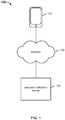
- FIG. 1 is a diagram showing an embodiment of a system for validating segments.
- system 100 includes device 102, network 104, and segment validation server 106.
- Network 104 includes high-speed data networks and/or telecommunications networks.
- Device 102 may communicate to segment validation server 106 over network 104.
- system 100 may include more or fewer components than what is shown in the example of FIG. 1 .
- Device 102 is a device that can record GPS data and/or other data associated with a physical activity.
- Device 102 can also be a device to which GPS data and/or other data associated with a physical activity can be uploaded or transferred.
- Examples of device 102 include, but are not limited to: a GPS device (e.g., Garmin Forerunner® and Edge® devices, including Garmin Forerunner® 110, 205, 301, 305, 310XT, 405, 405CX, and Garmin Edge® 305, 605, 705, 500, 800), a mobile phone, such as a smart phone (e.g., an Android®- based device or Apple iPhone® device) including a GPS recording application (e.g., MotionX®, Endomondo®, and RunKeeper®), a computer, a tablet device, and/or other general purpose computing devices and/or specialized computing devices, which typically include a general processor, a memory or other storage component(s), a network or input/output (I/O) capability, and
- device 102 (or an application thereof) is configured to record GPS data and auxiliary data associated with a physical activity during the activity.
- auxiliary data associated with a physical activity may include physiological, environmental, and/or performance data.
- device 102 is configured to receive recorded GPS data and auxiliary data associated with a physical activity subsequent to the completion of the activity (e.g., such information is uploaded to device 102).
- GPS data includes a series of consecutive and discrete GPS data points (e.g., latitude and longitude coordinates sometimes referred to as "Lat-Lng Data") with a timestamp for each point.
- auxiliary data includes, but is not limited to, elevation, heart rate, power/watts (e.g., energy expended), time, speed (e.g., average and/or maximum speed per segment and/or route, in which average speed, for example, can be derived from time and GPS information), and/or cadence.
- Auxiliary data can be recorded at various granularities.
- auxiliary data can correspond to each GPS data point, the entire activity (e.g., the auxiliary data includes averages of the metrics), or portions of the activity.
- device 102 is configured to store the recorded GPS data and the auxiliary data (e.g., effort) and/or send the effort information to server 106.
- device 102 is configured to present an interactive user interface. The user interface may display GPS data and receive selections (e.g., made by a user) with respect to the displays. In some embodiments, device 102 sends the selections that it receives to segment validation server 106.
- a user interface may be presented at device 102.
- the user interface may be presented by segment validation server 106 or by another component that is not shown in the example of FIG. 1 .
- the user interface is configured to receive a user definition of a segment.
- the user interface is configured to display a visual representation of the GPS data of a recorded effort at the user interface using a map software application.
- the visual representation can be, for example, a series of flags or a continuous line marked on a graphical map.
- segment validation server 106 is able to support a map at the user interface by including logic configured to interact with the Application Programming Interface (API) of a map software/application (e.g., Google® Maps, MapQuest®, Bing® maps, and/or another mapping application/service).
- API Application Programming Interface
- a user may define a segment using the visual representation of the GPS information.
- a start point and a finish (e.g., end) point along the visual representation of the GPS information are selected on the graphical map to define a segment. For example, a user may select (e.g., by dropping a marker or clicking) the start and/or finish points along the geographical track that he or she just traversed during a physical activity.
- the portion of the geographical track between the selected start and finish points is thus defined as a segment.
- the start and finish points are stored with the defined segment.
- the portion of the geographical track between the selected start and finish points is converted into an abstracted form and then stored in a database for storing segments.
- the associated data that corresponds to the defined segment is also stored with the segment at the database.
- the user interface is configured to receive a user definition of a segment using selections on a map without a visual representation of a recorded effort.
- a graphical map e.g., Google® Maps, MapQuest®
- a series of selections of points on the map is received.
- This series of selections of points on the map need not be based on a recorded effort and can merely be any geographical track that is of interest.
- the selected segment can be a track that a cyclist has rode over before but has not documented the ride or the selected segment can be a track that the cyclist would like to ride on in the future.
- the series of selections of points on the map can be converted into a series of GPS data (e.g., Lat-Lng Data).
- the series of GPS data is converted into an abstracted form and then stored as a segment.
- stored efforts e.g., sets of GPS data from past physical activities
- stored efforts are compared to the defined segment.
- an effort is compared against this defined segment, it is determined whether the effort matches the segment in part by checking whether the GPS data of the effort indicates that the start point and/or finish point of the segment have been crossed.
- Identifiers associated with matching efforts are stored for each segment.
- Segment validation server 106 is configured to validate a stored segment. Segment validation server 106 is configured to validate a stored segment based on aggregated GPS data associated with the segment. In some embodiments, aggregated GPS data associated with the segment includes at least some of the efforts that have been determined to match the segment. In some embodiments, segment validation server 106 is configured to start validation of a stored segment in response to a trigger to start the validation process. In response to the trigger, in some embodiments, segment validation server 106 is configured to use at least some of the GPS data associated with one or more efforts that have been determined to match the segment to adjust the GPS data associated with the segment. In some embodiments, adjusting the GPS data associated with the segment includes generating a new version of the segment.
- the new version of the segment may comprise a modified version of the set of GPS data associated with the previous version of the segment.
- the new version of the segment may also be referred to as the "validated segment.”
- the validated segment will replace the previous version of the segment.
- stored efforts, if any, that match the validated segment are determined.
- segment validation server 106 is configured to validate the validated segment based on aggregated GPS data (e.g., GPS data that matches the validated segment). In this manner, segment validation server 106 is configured to iteratively, over time, validate a segment using aggregated GPS data associated with the segment (e.g., GPS data associated with efforts that match the segment).
- Validating a segment leverages a body of relevant user submitted GPS data to generate a more accurate and/or more current representation of the intended geographic track. Only a portion of the relevant user submitted GPS data recorded by one or more GPS devices that are known to be more accurate may be selected to validate the segment, to increase the accuracy of the validation process. More accurate segments can provide better matches to recorded efforts and therefore increase the probability that an effort recorded along a certain geographic track will be determined to match the segment defined to represent that geographic track.
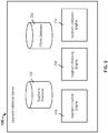
- FIG. 2 is a diagram showing an embodiment of a segment validation server.
- segment validation server 106 of system 100 of FIG. 1 may be implemented using the example of FIG. 2 .
- a segment validation server may include more or fewer components than what is shown in the example of FIG. 2 .
- the example of the segment validation server includes segments database 202, efforts database 204, segment creation engine 206, segment matching engine 208, and segment validation engine 210.
- Each of segments database 202 and efforts database 204 may be implemented using one or more databases.
- Each of segment creation engine 206, segment matching engine 208, and segment validation engine 210 may be implemented using one or both of hardware and software.
- Segments database 202 is configured to store segments. In some embodiments, segments database 202 is configured to store segments derived from recorded user efforts. In some embodiments, segments database 202 is configured to store segments generated by user selections along a map application (independent of a recorded effort). In some embodiments, segments database 202 is configured to store segments generated based on third party sources.
- a segment is stored as a set of GPS data. In some embodiments, the set of GPS data associated with a segment is converted into an abstracted form (e.g., minimum bounding rectangles) and the converted data is stored to represent the segment. In some embodiments, each segment is stored with a set of metadata.
- the set of metadata associated with each segment may include an identifier associated with the segment, a number of times that a segment associated with the segment identifier has been validated/refined (e.g., a version number of the segment associated with the segment identifier), identifiers of stored efforts that have been determined to match the segment (e.g., within a recent period of time or since the last time the segment was validated), a time at which the segment associated with the identifier was originally created, and one or more types of physical activity that are associated with the segment (e.g., running and biking).
- a segment has been validated at least once previously, then at least one or more previous versions of the segment may be stored (but not used to match to efforts).
- each segment stored at segments database 202 is associated with one or more matching criteria. If an effort is determined (e.g., by segment matching engine 208) to meet the criteria associated with a segment, then the effort is determined to match the segment and data indicating the matching relationship between the segment and the effort may be stored with the segment and/or the effort.
- matching criteria associated with a segment may include a threshold degree of similarity that an effort has to meet in order to match the segment.
- each segment stored at segments database 202 is associated with the same set of matching criteria. In some embodiments, different segments stored at segments database 202 may be associated with different sets of matching criteria.
- Segment creation engine 206 is configured to receive user definition of segments. In some embodiments, segment creation engine 206 is configured to present a user interface associated with segment definition. In some embodiments, a user may submit to segment creation engine 206 a set of GPS data associated with a recorded effort and segment creation engine 206 is configured to present a visual representation of the effort at the user interface. Then user selections associated with a start point and end point along the visual representation of the GPS data associated with the effort are received and segment creation engine 206 is configured to store at least the portion of the GPS data associated with the effort between the start point and the end point as a segment at segments database 202, for example.
- segment creation engine 206 is configured to present a map application (e.g., associated with a third party service such as Google® maps) at the user interface and receive one or more user selections (e.g., user clicks along a path on the map) with respect to the map application. The one or more user selections on the map application are then converted into a set of (e.g., GPS) data and stored as a segment at segments database 202, for example.
- segment creation engine 206 is configured to prompt the user (via the user interface) to input metadata associated with the segment. For example, the user may be prompted to input an identifier for the segment and one or more types of physical activity associated with the segment.
- Efforts database 204 is configured to store user recorded and uploaded efforts.
- an effort is recorded during a user's physical activity by a GPS-enabled device.
- Examples of a user's physical activity may include biking or running.
- Examples of a GPS-enabled device may include a GPS-enabled smart phone with an application associated with recording GPS data installed or a GPS-enabled watch.
- a user can wear a GPS-enabled device on his body as he performs a physical activity. The user can interact with the device to start and end recording.
- a user interface may be provided for the user and the user may upload a recorded effort using at least the user interface.
- the user can establish a wired or wireless connection between the GPS-enabled device and a computer to upload the data associated with the recorded effort(s), direct the web browser installed at the computer to a web address associated with the user interface, and upload the data associated with the recorded effort(s) to the segment validation server.
- the user interface may prompt the user to provide metadata to be associated with an uploaded effort such as, for example, an identifier, a type of physical activity associated with the effort, an identifier associated with the type of device the effort was recorded with, an identifier of a user associated with the effort, and additional notes.
- the set of metadata associated with an effort may be updated over time. For example, over time, an effort may be determined to match different or additional segments.
- an effort stored at efforts database 204 is matched against one or more segments stored at segments database 202.
- segment matching engine 208 is configured to compare the effort against each of the segments stored at segments database 202, for example, to determine whether the effort matches one or more segments.
- an effort is determined to match a segment based on the set of GPS data associated with the effort meeting one or more matching criteria associated with the segment.
- the effort is then stored with an identifier associated with the matching segment. As such, if efforts that match a certain segment are to be determined, then the efforts of efforts database 204 can be searched for those that are associated with the segment's identifier.
- Segment matching engine 208 is configured to match efforts to stored segments. In some embodiments, segment matching engine 208 is configured to determine whether at least some efforts stored at efforts database 204 match one or more segments stored at segments database 202. Segment matching engine 208 is configured to determine whether an effort meets the one or more matching criteria associated with a particular segment. In the event that segment matching engine 208 determines that an effort matches a segment, then data indicating the matching relationship between the segment and effort may be stored with the segment and/or the effort.
- Segment validation engine 210 is configured to validate segments.
- a goal of segment validation is to continuously improve the quality of a segment and to change the segment, if appropriate, to better reflect the true (e.g., real-world) geographical track that the segment is supposed to represent.
- segment validation engine 210 validates at least some of the segments stored at segments database 202.
- Segment validation engine 210 validates a segment based on aggregated GPS data.
- segment validation engine 210 performs validation on a segment that meets one or more validation criteria. For example, a validation criterion is that a predetermined period of time has passed since the segment has been created or last validated.
- a validation criterion is that a predetermined number of efforts (e.g., recorded by a particular GPS-enabled device) has been determined to match the segment. Yet another example of a validation criterion is that less than a predetermined threshold of efforts has been determined to match the segment since the segment has been created or last validated.
- segment validation engine 210 determines that a stored segment has met at least one validation criterion, segment validation engine 210 proceeds to validate the segment.
- segment validation engine 210 is configured to validate a stored segment based on aggregated GPS data including at least the set of efforts that have been determined to match the segment. For example, segment validation engine 210 can query efforts database 204 for the efforts that have been determined to match the segment to be validated (e.g., based on metadata stored with the efforts).
- segment validation engine 210 is configured to use at least the obtained efforts (e.g., the efforts' corresponding sets of GPS data) that have been determined to match the segment to validate the segment.
- segment validation engine 210 is configured to generate a new version of the segment based on the obtained set of efforts. In some embodiments, segment validation engine 210 is configured to replace the previous version of the segment with the new version of the segment as a result of the validation. In some embodiments, the new version of the segment, which is sometimes referred to as the "validated segment," is stored with at least some of the metadata (e.g., segment identifier) associated with the previous version of the segment so as to replace the previous version. In some embodiments, the metadata associated with the new version of the segment may be updated to include an incremented version number. In some embodiments, segment validation engine 210 is configured to match one or more efforts (from efforts database 204) to the validated segment.
- the metadata e.g., segment identifier
- segment validation engine 210 is configured to iteratively validate a segment based on aggregated GPS data. For example, the new version of the segment (the validated segment) may eventually meet a validation criterion and become validated by segment validation engine 210 based on the efforts that have been determined to match that version of the segment.
- a segment may be originally derived from the GPS data associated with a recorded user effort, sometimes the error included in the recording of the effort may be passed onto the resulting segment.
- certain efforts that were recorded with greater accuracy along the geographic track that a segment was intended to represent may not be determined to match the segment, which will negatively affect users' ability to compare performances along the same geographic track.
- the segment may be continually improved to more accurately reflect the current real-world shape of the geographic track.
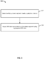
- FIG. 3 is a flow diagram showing a process of validating a segment.
- Process 300 can be implemented at system 100 of FIG. 1 .
- segment validation for a stored segment begins when the segment meets a validation criterion.
- One or more validation criterion may be user configured.
- a first example of a validation criterion is an elapse of a predetermined time interval since the segment was last validated or since the segment's initial creation.
- a second example of a validation criterion is when less than a predetermined number of efforts are determined to match the segment within a predetermined period of time (e.g., the lack of matching efforts may indicate that the segment was created with significant error).
- a third example of a validation criterion is when the number of efforts that match the segment has reached a predetermined threshold.
- a fourth example of a validation criterion is when the number of efforts recorded by a selected device (e.g., that is known to be relatively more accurate than other devices) that match the segment has reached a predetermined threshold.
- a fifth example of a validation criterion is receipt of an indication of a user selection to initiate the validation process.
- GPS data associated with the stored segment is adjusted using aggregated GPS data.
- sets of GPS data associated with the segment are aggregated and used to adjust the GPS data associated with the segment.
- Sets of GPS data associated with the segment comprise the GPS data associated with the efforts that have been determined to match the segment.
- the sets of GPS data corresponding to the matching efforts are obtained and used to generate a new version of the segment.
- the new version of the segment is used to replace the previous version of the segment.
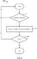
- FIG. 4 is a flow diagram showing a process for performing segment validation. Process 400 can be performed at system 100 of FIG. 1 .
- Process 400 shows that a segment may be repeatedly validated to further improve the accuracy and quality of the segment. Process 400 is performed for each stored segment.
- the segment is determined to be validated based on the segment meeting at least one validation criterion.
- validation criterion include an elapse of a predetermined time interval since a previous validation or creation of the segment, when the number of efforts determined to match the segment reaches a predetermined threshold number, when the number of matching efforts is less than a predetermined number during a predetermined period of time, and when an indication associated with a user selection for the segment to be validated is received.
- validation is performed on the stored segment.
- Aggregated GPS data associated with the segment is used to perform validation of the segment.
- a new version of the segment is generated and used to replace the previous version of the segment.
- step 406 it is determined whether to stop validation of the segment. For example, the cycle of segment validation may be stopped in response to a user selection to stop the process or in response to the system losing power. In the event that validation is determined to be stopped, process 400 ends. Otherwise, in the event that validation is determined to continue, control passes to the start of 400. For example, after one iteration of step 404, the new version of the segment is determined to replace the previous version of the segment. Then when the next iteration process 400 is performed, this new version of the segment is determined to be validated.
- FIG. 5 is a flow diagram showing an embodiment of a process of validating a segment.
- Process 500 is performed at system 100 of FIG. 1 .
- Step 404 of process 400 of FIG. 4 is performed using at least a portion of process 500.
- Process 500 shows that efforts may be compared against a newly generated validated segment (i.e., a new version of a segment generated from validating a segment).
- an indication to validate a stored segment is received.
- the stored segment is determined to have met a validation criterion.
- a first plurality of sets of GPS data associated with the stored segment is obtained.
- the first plurality of sets of GPS data comprises the sets of GPS data corresponding to the efforts that have been determined to match the stored segment since the segment was initially created or was last validated.
- a validated segment is generated based at least in part on the first plurality of sets of GPS data associated with the stored segment.
- the validated segment comprises a new version of the segment generated based on the set of efforts that had been determined to match the segment.
- the previous version of the segment which is the version of the segment prior to the current validation process, is replaced by the new version of the segment.
- Replacing a segment with a new version of the segment includes discarding the segment and storing the new version of the segment with at least some of the metadata that was stored for the discarded version.
- the metadata associated with the new version of the segment includes an incremented version number.
- the set of stored efforts is compared against the new version of the segment to determine which efforts match this new version.
- the validated segment may differ from the previous version of the segment enough such that efforts that did not previously match the previous version of the segment may match this new version and/or efforts that previously did match the previous version of the segment may not match the new version of the segment.
- identifiers of efforts that are determined to match the new version of the segment are stored with the segment so that such efforts may be used, in the future, to validate the formerly new version of the segment.
- FIG. 6 is a flow diagram showing an embodiment of the present invention of determining a validated segment.
- Process 600 can be performed at system 100 of FIG. 1 .
- Steps 502, 504, and 506 of process 500 of FIG. 5 can be performed using process 600.
- a stored segment to validate is determined. For example, the stored segment is determined to have met a validation criterion.
- a plurality of sets of GPS data associated with matching the stored segment is obtained.
- the plurality of sets of GPS data associated with matching the stored segment is associated with the efforts that have been determined to match the stored segment.
- a set of GPS data from the plurality of sets of GPS data is identified.
- the set of GPS data associated with one of the matching efforts is identified based on one or more factors.
- Each found matching effort may be thought as a candidate effort and the identified effort may be referred to as the "best candidate effort.”
- tests may be applied to each of a subset of the candidate efforts that are recorded by a selected device (e.g., a device being selected for being known to record with relatively more accuracy) and the candidate effort associated with the highest score based on the given tests is identified.
- the candidate effort identified as the "best candidate effort" is the effort that is determined to likely be the most accurate effort (e.g., the effort that was recorded with the most accuracy).
- the best candidate effort is identified by "walking along" each candidate effort and measuring a count of found GPS data points associated with other candidate efforts within a given radius of each GPS data point along that candidate effort. Each GPS data point is of standard distance interval from the previous and the next GPS data point from start to end of the candidate effort. A sum is determined for each candidate effort based on adding together the count of found GPS data points within the given radius of each of the candidate effort's GPS data points. The candidate effort that has the highest sum is determined to be the best candidate effort because it is closest to a centroid of the group of candidate efforts and as will be described below, the validated segment is determined by finding centroids associated with the group of candidate efforts.
- a centroid using at least the plurality of sets of GPS data for a GPS data point associated with the identified set of GPS data is determined.
- Each GPS data point of the best candidate effort is "walked along" to determine a centroid based on nearby GPS data points associated with at least some other candidate efforts. For example, for a given GPS data point of the best candidate effort (e.g., starting with the first recorded GPS data point), a radius of a certain distance is swept out around this GPS data point and at least some GPS data points associated with other candidate efforts within the swept out circle are used to determine a centroid. Only a subset of all candidate efforts is considered in validating the segment.
- a selected device e.g., a Garmin Edge® 800
- only candidate efforts that were recorded by a selected device are considered in validating the segment and so in determining a centroid for each GPS data point included in the best candidate effort, only GPS data points of efforts recorded by the selected device that are included in the radius of a certain distance from the GPS data point are used to find the centroid.
- the centroid technique also filters out GPS data points that are not going in the same general direction as the current best candidate effort GPS data point that is under consideration (i.e., GPS data points of candidate efforts that are not the best candidate efforts are not used to determine the centroid if they are not in the same general direction as the best candidate effort GPS data point).
- GPS data points of candidate efforts that are not the best candidate efforts are not used to determine the centroid if they are not in the same general direction as the best candidate effort GPS data point.
- the technique of finding a centroid is iterated through a predetermined number of times (e.g., four times) to determine the centroid.
- the rational for the multiple iterations is that a main corridor could be initially only touched by the area of the circle around the GPS data point of a best candidate effort - such that the centroid of those found GPS data points is still outside of the main corridor of GPS data points. It is found that multiple iterations enable the centroid to "march" to the corridor, and once there - it will stay there.
- next GPS data point in the identified set of GPS data is considered and control returns to 608.
- the next GPS data point (e.g., the GPS data point recorded next in time) of the best candidate effort is considered until each GPS data point of the best candidate effort is walked along to create a new centroid based on step 608.
- a validated segment is generated based at least in part on the one or more determined centroids.
- the centroids created based on walking along each GPS data point of the best candidate effort are connected to form the new version of the segment that is to replace the previous version.
- FIGS. 7 through 13 illustrate an example of performing process 600 of FIG. 6 to validate a segment.
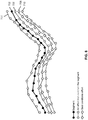
- FIG. 7 is a diagram showing an example of visual representations of a segment and efforts that have been determined to match the segment.
- a segment may be represented by a series of discrete GPS data points.
- GPS data point 712 is associated with segment 702.
- segment 702 may have been defined based on the GPS data associated with a particular user's uploaded effort. The user may have recorded an effort and indicated (e.g., via a user interface) a portion of the GPS data associated with the effort to store as segment 702.
- Each effort also corresponds to a series of discrete GPS data points.
- GPS data point 714 is associated with effort 704.
- the GPS data points of segment 702 are plotted in a two-dimensional space (associated with latitudinal and longitudinal coordinates).
- the GPS data points of four user uploaded efforts (effort 704, effort 706, effort 708, and effort 710) that have been determined to match segment 702 are also plotted in the same space. If it is assumed that it is determined that a validation process is to begin on segment 702 (e.g., because segment 702 has met a validation criterion), then at least some of the efforts that have been determined to match segment 702 are used to validate segment 702. In the example, all four matching efforts, effort 704, effort 706, effort 708, and effort 710, are used to validate segment 702. Each of effort 704, effort 706, effort 708, and effort 710 may be recorded by the same or different GPS-enabled devices. In some embodiments, only matching efforts that are recorded by a selected type of GPS-enabled device are used to validate the segment (e.g., because the selected type of GPS-enabled device is determined to be relatively more accurate).
- segment 702 may have been defined based on user Steve's uploaded effort associated with a bike ride. Steve may have recorded the bike ride and indicated (e.g., via a user interface) a portion of the geography covered by the bike ride to store as segment 702. For example, Steve may input the identifier of "Montalvo hill climb" for segment 702 to denote the name of the popular climb that he biked over and the geographical track that segment 702 is intended to represent. Over time, other users have recorded various efforts that have been determined to match segment 702 and such efforts include at least effort 704, effort 706, effort 708, and effort 710.
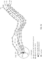
- FIG. 8 is a diagram showing an example of selecting a best candidate effort.
- one of the matching efforts is identified as the best candidate effort.
- an effort may be identified as the best candidate effort as a result of determining that the effort is associated with the highest sum of the counts of GPS data points in the vicinity of each of its GPS data points.
- the best candidate effort is to serve as a reference effort to use in determining the validated segment (i.e., the new version of segment 702).
- effort 708 is determined to be the best candidate effort.
- FIG. 9 is a diagram showing the determination of a centroid based on a GPS data point of the best candidate effort.
- each GPS data point of the best candidate effort is used to form the center of a circular area (e.g., of a predetermined radius) for which at least a subset of GPS data points associated with the other considered matching efforts (and in some embodiments, the original segment, segment 702) enclosed in the circular area is used to determine a centroid.
- the centroid is associated with its own set of Lat-Lng coordinates.
- a centroid determination function may be applied a predetermined number of times (e.g., four) on the GPS data points included in the circular area centered on the current GPS data point of the best candidate effort for such GPS data points to converge into a centroid.
- GPS data point 902 of the best candidate effort, effort 708, is the current GPS data point around which the circular area 904 is drawn.
- the GPS data points of the other efforts (effort 704, effort 706, and effort 710) that are included in circular area 904 are used to compute a centroid.
- FIG. 10 is a diagram showing a centroid determined based on a GPS data point of the best candidate effort.
- centroid 1002 is computed based on at least a subset of the GPS data points of the other efforts (effort 704, effort 706, and effort 710) that are included in circular area 904. Each subsequent GPS data point of the best candidate effort can be similarly used to determine a corresponding centroid.
- the centroid associated with the first GPS data point of the best candidate effort such as GPS data point 902 of the best candidate effort in the example
- only the first data point of each of the other candidate efforts e.g., such as GPS data point 1004 of effort 710 are considered so that the centroid will fall along the same start plane as the original segment, segment 702. Making sure that the centroid falls along the same start and end planes as the segment before the validation will help preserve the length of the segment.
- FIG. 11 is a diagram showing various centroids determined based on corresponding GPS data points of the best candidate effort. Continuing the example of FIG. 10 , in FIG. 11 , subsequent GPS data points in the best candidate effort are walked along and used to determine a corresponding centroid. In the example, a centroid corresponding to GPS data point 1102 of the best candidate effort is currently being determined using at least circular area 1104.
- FIG. 12 is a diagram showing determined centroids corresponding to all the GPS data points of the best candidate effort. Continuing the example of FIG. 11 , FIG. 12 shows corresponding centroids having been determined for each GPS data point of the best candidate effort. In some embodiments, in determining the centroid associated with the last GPS data point of the best candidate effort, only the last GPS data point of each of the other matching efforts are considered so that the centroid will fall along the same end plane as the original segment, segment 702.
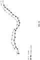
- FIG. 13 is a diagram showing a validated segment determined based on the determined centroids. Continuing the example of FIG. 12 , FIG. 13 shows all the determined centroids corresponding to each GPS data point of the best candidate effort.
- Such centroids can be stored to represent the validated segment, segment 1202, which is the new version of the segment that was validated, segment 702.
- segment 1202 may be stored with at least some of the metadata that was previously associated with segment 1202 (e.g., the identifier of "Montalvo hill climb") such that segment 1202 can replace segment 702.
- Existing and new efforts can be compared to segment 1202 to determine matching efforts.
- Another example of generating a validated segment includes finding an average of all the GPS data points included in each circular area centered on each GPS data point of the best candidate effort.
- Yet another example of generating a validating segment includes inputting the GPS data associated with the segment to be validated and the matching efforts in a GIS program.
- the GPS data can be converted into a raster image. Different colors may be applied to areas of the raster image with different densities. For example, the areas with the highest densities may be colored in white. The white portions of the raster image may be connected to form the validated segment.
Landscapes
- Engineering & Computer Science (AREA)
- Remote Sensing (AREA)
- Radar, Positioning & Navigation (AREA)
- Physics & Mathematics (AREA)
- General Physics & Mathematics (AREA)
- Automation & Control Theory (AREA)
- Theoretical Computer Science (AREA)
- Databases & Information Systems (AREA)
- Computer Networks & Wireless Communication (AREA)
- General Engineering & Computer Science (AREA)
- Data Mining & Analysis (AREA)
- Computer Security & Cryptography (AREA)
- Position Fixing By Use Of Radio Waves (AREA)
- Navigation (AREA)
Claims (11)
- System (100) zum Validieren eines gespeicherten Segments (702), wobei das gespeicherte Segment aus GPS-Daten besteht, umfassend:
einen oder mehrere Prozessoren, die für Folgendes konfiguriert sind:Bestimmen (302), dass das gespeicherte Segment (702) ein Validierungskriterium erfüllt; undValidieren des gespeicherten Segments;wobei das Validieren des gespeicherten Segments die folgenden Schritte beinhaltet: Bestimmen (604), dass eine Vielzahl von Anstrengungen (704, 706, 708, 710) mit dem gespeicherten Segment (702) übereinstimmt, wobei die Vielzahl von Anstrengungen (704, 706, 708, 710) mit entsprechenden von einer Vielzahl von Beispielen von sportlichen Aktivitäten assoziiert ist, wobei eine Anstrengung eine aufgezeichnete Reihe von GPS-Daten mit Zeitstempeln umfasst;Auswählen einer Anstrengung aus der Vielzahl von Anstrengungen (704, 706, 708, 710); undIdentifizieren der Untermenge von GPS-Datenpunkten, die mit der Vielzahl von Anstrengungen (704, 706, 708, 710) assoziiert sind, innerhalb jeder Kreisfläche (904, 1104), die sich auf jeden der GPS-Punkte, die mit der ausgewählten Anstrengung assoziiert sind, konzentriert; undBestimmen eines Schwerpunkts auf der Basis des identifizierten Teils der Sätze GPS-Daten; undErzeugen (614) eines validierten Segments auf der Basis der bestimmten Schwerpunkte;einen oder mehrere Speicher, die mit dem einen oder den mehreren Prozessoren gekoppelt sind und konfiguriert sind, um das validierte Segment zu speichern. - Verfahren zum Validieren eines gespeicherten Segments, das aus GPS-Daten besteht, und umfassend:Bestimmen (302), dass das gespeicherte Segment (702) ein Validierungskriterium erfüllt; undValidieren des gespeicherten Segments;wobei das Validieren des gespeicherten Segments die folgenden Schritte beinhaltet:Bestimmen (604), dass eine Vielzahl von Anstrengungen (704, 706, 708, 710) mit dem gespeicherten Segment (702) übereinstimmt, wobei die Vielzahl von Anstrengungen (704, 706, 708, 710) mit entsprechenden von einer Vielzahl von Beispielen von sportlichen Aktivitäten assoziiert ist, wobei eine Anstrengung eine aufgezeichnete Reihe von GPS-Daten mit Zeitstempeln umfasst;Auswählen einer Anstrengung aus der Vielzahl von Anstrengungen (704, 706, 708, 710); undIdentifizieren der Untermenge von GPS-Datenpunkten, die mit der Vielzahl von Anstrengungen (704, 706, 708, 710) assoziiert sind, innerhalb jeder Kreisfläche (904, 1104), die sich auf jeden der GPS-Punkte, die mit der ausgewählten Anstrengung assoziiert sind, konzentriert; undBestimmen eines Schwerpunkts auf der Basis des identifizierten Teils der Sätze GPS-Daten; undErzeugen (614) eines validierten Segments auf der Basis der bestimmten Schwerpunkte;einen oder mehrere Speicher, die mit dem einen oder den mehreren Prozessoren gekoppelt sind und konfiguriert sind, um das validierte Segment zu speichern.
- System nach Anspruch 1 oder Verfahren nach Anspruch 2, wobei das Validierungskriterium eines oder mehrere von Folgendem umfasst: eine vorgegebene Zeitdauer ist seit dem Kreieren oder dem letzten Validieren des Segments (702) vergangen, eine vorgegebene Anzahl von Anstrengungen ist als mit dem Segment (702) übereinstimmend bestimmt worden, seit dem Kreieren oder dem letzten Validieren des Segments (702) ist weniger als ein vorgegebener Schwellenwert von Anstrengungen als mit dem Segment (702) übereinstimmend bestimmt worden und Empfang einer Angabe einer Benutzerauswahl, um einen Validierungsprozess zu initiieren.
- System oder Verfahren nach Anspruch 3, wobei die vorgegebene Anzahl von Anstrengungen (704), die als mit dem Segment (702) übereinstimmend bestimmt worden ist, mit einer ausgewählten GPS-fähigen Vorrichtung (102) assoziiert ist.
- System nach Anspruch 1 oder Verfahren nach Anspruch 2, wobei die Vielzahl von Anstrengungen (704, 706, 708, 710) eine erste Vielzahl von Anstrengungen umfasst und wobei der eine oder die mehreren Prozessoren ferner konfiguriert sind, um zu bestimmen, ob irgendeine von einer zweiten Vielzahl von Anstrengungen mit dem erzeugten validierten Segment übereinstimmt.
- System nach Anspruch 1 oder Verfahren nach Anspruch 2, wobei die Vielzahl von Anstrengungen (704, 706, 708, 710) mit einer ausgewählten GPS-fähigen Vorrichtung (102) assoziiert ist.
- Computerprogrammprodukt zum Validieren eines gespeicherten Segments, das aus GPS-Daten besteht, wobei das Computerprogrammprodukt in einem computerlesbaren Speichermedium enthalten ist und Computeranweisungen für Folgendes umfasst:Bestimmen (302), dass das gespeicherte Segment (702) ein Validierungskriterium erfüllt; undValidieren des gespeicherten Segments;wobei das Validieren des gespeicherten Segments die folgenden Schritte beinhaltet:Bestimmen (604), dass eine Vielzahl von Anstrengungen (704, 706, 708, 710) mit dem gespeicherten Segment (702) übereinstimmt, wobei die Vielzahl von Anstrengungen (704, 706, 708, 710) mit entsprechenden von einer Vielzahl von Beispielen von sportlichen Aktivitäten assoziiert ist, wobei eine Anstrengung eine aufgezeichnete Reihe von GPS-Daten mit Zeitstempeln umfasst;Auswählen einer Anstrengung aus der Vielzahl von Anstrengungen (704, 706, 708, 710); undIdentifizieren der Untermenge von GPS-Datenpunkten, die mit der Vielzahl von Anstrengungen (704, 706, 708, 710) assoziiert sind, innerhalb jeder Kreisfläche (904, 1104), die sich auf jeden der GPS-Punkte, die mit der ausgewählten Anstrengung assoziiert sind, konzentriert; undBestimmen eines Schwerpunkts auf der Basis des identifizierten Teils der Sätze GPS-Daten; undErzeugen (614) eines validierten Segments auf der Basis der bestimmten Schwerpunkte;einen oder mehrere Speicher, die mit dem einen oder den mehreren Prozessoren gekoppelt sind und konfiguriert sind, um das validierte Segment zu speichern.
- System nach Anspruch 1 oder Verfahren nach Anspruch 2, wobei das Auswählen der Anstrengung aus der Vielzahl von Anstrengungen das Bestimmen einer Bewertung (606) umfasst, die mit jeder Anstrengung von mindestens einer Untermenge der Vielzahl von Anstrengungen assoziiert ist.
- System oder Verfahren nach Anspruch 8, wobei das Bestimmen der Bewertung, die mit jeder Anstrengung der mindestens einen Untermenge der Vielzahl von Anstrengungen assoziiert ist, Folgendes beinhaltet:Bestimmen, für jeden GPS-Punkt, der mit jeder Anstrengung assoziiert ist, einer Zahl von GPS-Punkten, die mit den anderen der Vielzahl von Anstrengungen assoziiert sind, innerhalb eines vorgegebenen Radius von diesem GPS-Punkt;Bestimmen, für jede Anstrengung, eine Summe der gezählten GPS-Punkte, die entsprechenden des Satzes GPS-Punkten, die mit dieser Anstrengung assoziiert sind, entspricht; undwobei die Bewertung (606), die mit jeder Anstrengung assoziiert ist, die Summe umfasst.
- Computerprogrammprodukt nach Anspruch 7, wobei das Validierungskriterium eines oder mehrere von Folgendem umfasst: eine vorgegebene Zeitdauer ist seit dem Kreieren oder dem letzten Validieren des Segments (702) vergangen, eine vorgegebene Anzahl von Anstrengungen ist als mit dem Segment (702) übereinstimmend bestimmt worden, seit dem Kreieren oder dem letzten Validieren des Segments (702) ist weniger als ein vorgegebener Schwellenwert von Anstrengungen als mit dem Segment (702) übereinstimmend bestimmt worden und Empfang einer Angabe einer Benutzerauswahl, um einen Validierungsprozess zu initiieren.
- Computerprogrammprodukt nach Anspruch 10, wobei die vorgegebene Anzahl von Anstrengungen (704), die als mit dem Segment (702) übereinstimmend bestimmt worden ist, mit einer ausgewählten GPS-fähigen Vorrichtung (102) assoziiert ist.
Applications Claiming Priority (3)
| Application Number | Priority Date | Filing Date | Title |
|---|---|---|---|
| US201261609847P | 2012-03-12 | 2012-03-12 | |
| US13/788,392 US8996301B2 (en) | 2012-03-12 | 2013-03-07 | Segment validation |
| PCT/US2013/029887 WO2013138181A1 (en) | 2012-03-12 | 2013-03-08 | Segment validation |
Publications (3)
| Publication Number | Publication Date |
|---|---|
| EP2825850A1 EP2825850A1 (de) | 2015-01-21 |
| EP2825850A4 EP2825850A4 (de) | 2015-11-04 |
| EP2825850B1 true EP2825850B1 (de) | 2019-05-22 |
Family
ID=49114836
Family Applications (2)
| Application Number | Title | Priority Date | Filing Date |
|---|---|---|---|
| EP13761191.9A Active EP2825902B1 (de) | 2012-03-12 | 2013-03-08 | Reparatur von gps-daten |
| EP13760859.2A Active EP2825850B1 (de) | 2012-03-12 | 2013-03-08 | Segmentvalidierung |
Family Applications Before (1)
| Application Number | Title | Priority Date | Filing Date |
|---|---|---|---|
| EP13761191.9A Active EP2825902B1 (de) | 2012-03-12 | 2013-03-08 | Reparatur von gps-daten |
Country Status (4)
| Country | Link |
|---|---|
| US (5) | US8718927B2 (de) |
| EP (2) | EP2825902B1 (de) |
| ES (1) | ES2744865T3 (de) |
| WO (2) | WO2013138181A1 (de) |
Cited By (2)
| Publication number | Priority date | Publication date | Assignee | Title |
|---|---|---|---|---|
| EP3524932A1 (de) * | 2018-02-13 | 2019-08-14 | Topcon Corporation | Datenverarbeitungsvorrichtung, datenverarbeitungsverfahren und datenverarbeitungsprogramm |
| US10805763B2 (en) | 2017-12-18 | 2020-10-13 | LapKing Holdings, LLC | System and method for tracking a vehicle's course by comparing geolocation data from a known course |
Families Citing this family (57)
| Publication number | Priority date | Publication date | Assignee | Title |
|---|---|---|---|---|
| US9174085B2 (en) | 2012-07-31 | 2015-11-03 | John Paul Foley | Exercise system and method |
| US11610664B2 (en) | 2012-07-31 | 2023-03-21 | Peloton Interactive, Inc. | Exercise system and method |
| US9881075B2 (en) * | 2013-07-30 | 2018-01-30 | Excalibur Ip, Llc | Method and apparatus for accurate localization of points of interest using a world shape |
| GB201317033D0 (en) * | 2013-09-25 | 2013-11-06 | Naylor David | Selecting routes |
| US20150256977A1 (en) * | 2014-03-04 | 2015-09-10 | Apple Inc. | Determining Activity Paths from Anonymous Application Usage Data and Motion Activity |
| US9913100B2 (en) | 2014-05-30 | 2018-03-06 | Apple Inc. | Techniques for generating maps of venues including buildings and floors |
| US9823969B2 (en) | 2014-09-02 | 2017-11-21 | Netapp, Inc. | Hierarchical wide spreading of distributed storage |
| US9767104B2 (en) * | 2014-09-02 | 2017-09-19 | Netapp, Inc. | File system for efficient object fragment access |
| US20160062832A1 (en) | 2014-09-02 | 2016-03-03 | Netapp. Inc. | Wide spreading data storage architecture |
| KR101704565B1 (ko) * | 2014-11-27 | 2017-02-08 | 현대자동차주식회사 | 차량 운행 정보 수집 장치, 그 수집 방법, 및 차량 운행 정보를 이용한 서비스 시스템 |
| US9817715B2 (en) | 2015-04-24 | 2017-11-14 | Netapp, Inc. | Resiliency fragment tiering |
| US9431061B1 (en) | 2015-04-24 | 2016-08-30 | Netapp, Inc. | Data write deferral during hostile events |
| KR101765196B1 (ko) * | 2015-09-02 | 2017-08-07 | 현대자동차주식회사 | 차량 및 맵 생성방법 |
| US10429192B2 (en) | 2015-09-16 | 2019-10-01 | Strava, Inc. | Generating trail network maps |
| US12468467B2 (en) | 2015-10-31 | 2025-11-11 | Netapp, Inc. | Sequential write based durable file system |
| US10379742B2 (en) | 2015-12-28 | 2019-08-13 | Netapp, Inc. | Storage zone set membership |
| US10514984B2 (en) | 2016-02-26 | 2019-12-24 | Netapp, Inc. | Risk based rebuild of data objects in an erasure coded storage system |
| US10055317B2 (en) | 2016-03-22 | 2018-08-21 | Netapp, Inc. | Deferred, bulk maintenance in a distributed storage system |
| US10309792B2 (en) | 2016-06-14 | 2019-06-04 | nuTonomy Inc. | Route planning for an autonomous vehicle |
| US10126136B2 (en) | 2016-06-14 | 2018-11-13 | nuTonomy Inc. | Route planning for an autonomous vehicle |
| US11092446B2 (en) | 2016-06-14 | 2021-08-17 | Motional Ad Llc | Route planning for an autonomous vehicle |
| US20170356748A1 (en) * | 2016-06-14 | 2017-12-14 | nuTonomy Inc. | Route Planning for an Autonomous Vehicle |
| US10829116B2 (en) | 2016-07-01 | 2020-11-10 | nuTonomy Inc. | Affecting functions of a vehicle based on function-related information about its environment |
| US10681513B2 (en) | 2016-10-20 | 2020-06-09 | nuTonomy Inc. | Identifying a stopping place for an autonomous vehicle |
| US10473470B2 (en) | 2016-10-20 | 2019-11-12 | nuTonomy Inc. | Identifying a stopping place for an autonomous vehicle |
| US10857994B2 (en) | 2016-10-20 | 2020-12-08 | Motional Ad Llc | Identifying a stopping place for an autonomous vehicle |
| US10331129B2 (en) | 2016-10-20 | 2019-06-25 | nuTonomy Inc. | Identifying a stopping place for an autonomous vehicle |
| US11003978B2 (en) | 2016-12-14 | 2021-05-11 | Ajay Khoche | Programmable network node roles in hierarchical communications network |
| US10482369B2 (en) | 2016-12-14 | 2019-11-19 | Trackonomy Systems, Inc. | Window based locationing of mobile targets using complementary position estimates |
| EP3358303B1 (de) | 2017-02-07 | 2021-09-01 | HERE Global B.V. | Vorrichtung und zugehörige verfahren zur verwendung bei der aktualisierung von kartendaten |
| US11536576B2 (en) * | 2017-02-23 | 2022-12-27 | Here Global B.V. | Map data compatibility processing architecture |
| CN107728178B (zh) * | 2017-09-29 | 2024-08-09 | 杭州吉吉知识产权运营有限公司 | 一种运动轨迹的处理方法及装置 |
| CN107862068B (zh) * | 2017-11-17 | 2021-01-19 | 深圳广联赛讯股份有限公司 | 数据处理方法、装置及计算机可读存储介质 |
| US10102415B1 (en) * | 2018-03-29 | 2018-10-16 | Secugen Corporation | Method and apparatus for simultaneous multiple fingerprint enrollment |
| US11062063B2 (en) * | 2018-04-09 | 2021-07-13 | International Business Machines Corporation | System and method for generating vehicle travel data |
| US11487720B2 (en) * | 2018-05-08 | 2022-11-01 | Palantir Technologies Inc. | Unified data model and interface for databases storing disparate types of data |
| US11567632B2 (en) | 2018-07-03 | 2023-01-31 | Apple Inc. | Systems and methods for exploring a geographic region |
| DE102018219220A1 (de) | 2018-11-12 | 2020-05-14 | Robert Bosch Gmbh | Erstellung und Aktualisierung von Karten im Off-Street Bereich |
| US11625051B2 (en) * | 2019-01-25 | 2023-04-11 | Uber Technologies, Inc. | Proactive generation of tuning data for autonomous vehicle dispatch |
| KR20210152549A (ko) | 2019-05-01 | 2021-12-15 | 스위프트 내비게이션, 인크. | 고-무결성 위성 포지셔닝을 위한 시스템 및 방법 |
| CN110188777B (zh) * | 2019-05-31 | 2023-08-25 | 东莞先知大数据有限公司 | 一种基于数据挖掘的多周期钢轨伤损数据对齐方法 |
| CN110927768A (zh) * | 2019-11-08 | 2020-03-27 | 广东高驰运动科技有限公司 | 基于移动坐标定位的测距方法及便携式终端设备 |
| CN111190891B (zh) * | 2019-12-27 | 2023-07-25 | 武汉长江通信产业集团股份有限公司 | 一种多语义轨迹数据分段存储方法 |
| US11144369B2 (en) | 2019-12-30 | 2021-10-12 | Bank Of America Corporation | Preemptive self-healing of application server hanging threads |
| CN115485584B (zh) | 2020-02-14 | 2025-05-30 | 斯威夫特导航股份有限公司 | 用于重新收敛gnss位置估计的系统和方法 |
| US11768083B2 (en) | 2020-05-15 | 2023-09-26 | Apple Inc. | User interfaces for providing navigation directions |
| US11846515B2 (en) | 2020-06-11 | 2023-12-19 | Apple Inc. | User interfaces for customized navigation routes |
| US12047841B2 (en) | 2020-09-21 | 2024-07-23 | Trackonomy Systems, Inc. | Detecting special events and strategically important areas in an IoT tracking system |
| US11819305B1 (en) | 2020-10-05 | 2023-11-21 | Trackonomy Systems, Inc. | Method for determining direction of movement through gates and system thereof |
| CN112380230B (zh) * | 2020-12-03 | 2021-07-06 | 腾讯科技(深圳)有限公司 | 位置参数更新方法、装置、计算机设备及存储介质 |
| US20220185315A1 (en) * | 2020-12-15 | 2022-06-16 | Uber Technologies, Inc. | Authentication of Autonomous Vehicle Travel Networks |
| WO2022133294A1 (en) * | 2020-12-17 | 2022-06-23 | Swift Navigation, Inc. | System and method for fusing dead reckoning and gnss data streams |
| US11761773B2 (en) * | 2021-01-18 | 2023-09-19 | Azuga, Inc. | Method and system for path reconstruction of periodically sampled geographical position data |
| US12281912B2 (en) | 2021-06-07 | 2025-04-22 | Apple Inc. | User interfaces for maps and navigation |
| EP4334683A2 (de) | 2021-06-07 | 2024-03-13 | Apple Inc. | Benutzerschnittstellen für karten und navigation |
| US12372364B2 (en) | 2021-12-03 | 2025-07-29 | Terrain Scouts LLC | Systems, methods, and storage media for path validation |
| US12292292B2 (en) * | 2022-08-07 | 2025-05-06 | Adam Mancini | System and method of observing and measuring dismount land navigation |
Family Cites Families (67)
| Publication number | Priority date | Publication date | Assignee | Title |
|---|---|---|---|---|
| DE69219006T2 (de) * | 1991-05-21 | 1997-11-13 | Matsushita Electric Ind Co Ltd | Fahrzeugpositionsbestimmungsvorrichtung |
| JP2826086B2 (ja) | 1995-12-28 | 1998-11-18 | アルパイン株式会社 | ナビゲーション装置 |
| US6029173A (en) | 1997-11-26 | 2000-02-22 | Navigation Technologies Corporation | Method and system for representation and use of shape information in geographic databases |
| US6013007A (en) * | 1998-03-26 | 2000-01-11 | Liquid Spark, Llc | Athlete's GPS-based performance monitor |
| US7454002B1 (en) | 2000-01-03 | 2008-11-18 | Sportbrain, Inc. | Integrating personal data capturing functionality into a portable computing device and a wireless communication device |
| US6282486B1 (en) | 2000-04-03 | 2001-08-28 | International Business Machines Corporation | Distributed system and method for detecting traffic patterns |
| AU2002255568B8 (en) | 2001-02-20 | 2014-01-09 | Adidas Ag | Modular personal network systems and methods |
| US7080065B1 (en) | 2001-06-22 | 2006-07-18 | Oracle International Corporation | Query pruning using interior rectangles in an R-tree index |
| JP2003065784A (ja) * | 2001-08-28 | 2003-03-05 | Vertex Standard Co Ltd | Gpsナビゲーション装置 |
| US7480512B2 (en) * | 2004-01-16 | 2009-01-20 | Bones In Motion, Inc. | Wireless device, program products and methods of using a wireless device to deliver services |
| US6837827B1 (en) | 2003-06-17 | 2005-01-04 | Garmin Ltd. | Personal training device using GPS data |
| US20050033515A1 (en) | 2003-08-07 | 2005-02-10 | Motorola, Inc. | Wireless personal tracking and navigation system |
| US20050049765A1 (en) | 2003-08-27 | 2005-03-03 | Sacagawea21 Inc. | Method and apparatus for advertising assessment using location and temporal information |
| DE602004023313D1 (de) | 2003-09-30 | 2009-11-05 | Kenwood Corp | Führungsroutensuchverfahren |
| WO2005076031A2 (en) * | 2003-10-06 | 2005-08-18 | Sirf Technology, Inc. | A system and method for augmenting a satellite-based navigation solution |
| FR2861491B1 (fr) | 2003-10-24 | 2006-01-06 | Thales Sa | Procede de selection d'unites de synthese |
| FI118148B (fi) * | 2003-12-05 | 2007-07-31 | Elisa Oyj | Menetelmä, mittalaite, tietokoneohjelma ja järjestelmä palautteen antamiseksi käyttäjälle toiminnan aikana |
| DE102004013629B4 (de) | 2004-03-19 | 2023-06-01 | Volkswagen Ag | Kommunikationssystem für ein Kraftfahrzeug |
| US7901292B1 (en) | 2004-04-15 | 2011-03-08 | Navteq North America, Llc | Method for comparing performances on remotely located courses |
| US7672778B1 (en) | 2004-07-20 | 2010-03-02 | Navteq North America, Llc | Navigation system with downloaded map data |
| GB0420097D0 (en) * | 2004-09-10 | 2004-10-13 | Cotares Ltd | Apparatus for and method of providing data to an external application |
| US7254516B2 (en) | 2004-12-17 | 2007-08-07 | Nike, Inc. | Multi-sensor monitoring of athletic performance |
| US7693817B2 (en) * | 2005-06-29 | 2010-04-06 | Microsoft Corporation | Sensing, storing, indexing, and retrieving data leveraging measures of user activity, attention, and interest |
| US7828697B1 (en) | 2005-09-23 | 2010-11-09 | Garmin Switzerland Gmbh | Portable personal training device |
| JP5082295B2 (ja) * | 2006-05-19 | 2012-11-28 | 株式会社デンソー | 地図データ提供装置 |
| US7787857B2 (en) * | 2006-06-12 | 2010-08-31 | Garmin Ltd. | Method and apparatus for providing an alert utilizing geographic locations |
| CN103028228B (zh) | 2006-09-07 | 2015-08-12 | 耐克创新有限合伙公司 | 运动表现感测系统和方法 |
| US7771320B2 (en) | 2006-09-07 | 2010-08-10 | Nike, Inc. | Athletic performance sensing and/or tracking systems and methods |
| US20080082254A1 (en) | 2006-10-02 | 2008-04-03 | Yka Huhtala | Route-assisted GPS location sensing via mobile device |
| CN101563625A (zh) | 2006-11-06 | 2009-10-21 | 电子地图有限公司 | 用于二维和三维精确位置和定向确定的布置和方法 |
| FR2908323B1 (fr) | 2006-11-09 | 2009-01-16 | Parrot Sa | Procede de definition d'un referentiel commun pour un systeme de jeux video |
| CA2597347A1 (en) * | 2006-11-30 | 2008-05-30 | Ittay Ronen | Automated travel log system |
| US8160815B2 (en) | 2007-01-10 | 2012-04-17 | Tomtom International B.V. | Navigation device and method for informational screen display |
| CN101622550B (zh) | 2007-03-01 | 2013-09-18 | 艾利森电话股份有限公司 | 用于竞赛期间跟踪竞争者的移动服务 |
| JP5064870B2 (ja) * | 2007-04-17 | 2012-10-31 | 株式会社日立製作所 | デジタル道路地図の生成方法及び地図生成システム |
| US8930135B2 (en) | 2007-04-17 | 2015-01-06 | Esther Abramovich Ettinger | Device, system and method of landmark-based routing and guidance |
| DE102007028401B4 (de) | 2007-06-15 | 2011-08-25 | Navigon Ag, 20251 | Verfahren zum Betrieb einer Navigationseinrichtung |
| JP4453728B2 (ja) * | 2007-08-07 | 2010-04-21 | 株式会社デンソー | 位置補正装置 |
| US8121785B2 (en) | 2007-08-28 | 2012-02-21 | Garmin Switzerland Gmbh | Bicycle computer having position-determining functionality |
| US7885764B2 (en) | 2007-09-06 | 2011-02-08 | GM Global Technology Operations LLC | Method for adaptively constructing and revising road maps |
| US8234264B2 (en) | 2008-02-08 | 2012-07-31 | International Business Machines Corporation | System and method for preferred services in nomadic environments |
| US8015144B2 (en) | 2008-02-26 | 2011-09-06 | Microsoft Corporation | Learning transportation modes from raw GPS data |
| US8047966B2 (en) | 2008-02-29 | 2011-11-01 | Apple Inc. | Interfacing portable media devices and sports equipment |
| US8108139B1 (en) | 2008-02-29 | 2012-01-31 | Williams-Pyro, Inc. | System and method for route representation with waypoint storage |
| WO2009111472A2 (en) * | 2008-03-03 | 2009-09-11 | Nike, Inc. | Interactive athletic equipment system |
| US8260006B1 (en) | 2008-03-14 | 2012-09-04 | Google Inc. | System and method of aligning images |
| US8512211B2 (en) | 2008-09-05 | 2013-08-20 | Apple Inc. | Method for quickstart workout generation and calibration |
| US9409052B2 (en) * | 2008-10-03 | 2016-08-09 | Adidas Ag | Program products, methods, and systems for providing location-aware fitness monitoring services |
| US20100131184A1 (en) * | 2008-11-21 | 2010-05-27 | Richard Stanton | Method for creating suggested pathways for helping pedestrians cross open spaces |
| US8880568B2 (en) * | 2008-12-16 | 2014-11-04 | Here Global B.V. | Report generation for a navigation-related database |
| US10161758B2 (en) | 2009-01-16 | 2018-12-25 | Tomtom Global Content B.V. | Method for creating speed profiles for digital maps |
| EP2409288A1 (de) | 2009-03-16 | 2012-01-25 | Tom Tom Polska SP. Z.O.O. | Verfahren zum aktualisieren von digitalen karten unter verwendung von höheninformationen |
| EP2584414B1 (de) | 2009-04-26 | 2018-11-28 | NIKE Innovate C.V. | Sportuhr |
| WO2011023247A1 (en) | 2009-08-25 | 2011-03-03 | Tele Atlas B.V. | Generating raster image representing road existence probability based on probe measurements |
| US8271497B2 (en) | 2009-12-03 | 2012-09-18 | Sony Computer Entertainment Inc. | Information processing apparatus and information processing method outputting information on movement of person |
| US9304005B2 (en) * | 2009-12-04 | 2016-04-05 | GM Global Technology Operations LLC | Application programming interface (API) for navigation applications that merges incremental updates with existing map database |
| US8401250B2 (en) | 2010-02-19 | 2013-03-19 | MindTree Limited | Detecting objects of interest in still images |
| US9261376B2 (en) | 2010-02-24 | 2016-02-16 | Microsoft Technology Licensing, Llc | Route computation based on route-oriented vehicle trajectories |
| JP5511060B2 (ja) * | 2010-03-23 | 2014-06-04 | アイシン・エィ・ダブリュ株式会社 | 地図更新データ供給装置及び地図更新データ供給プログラム |
| US8843340B2 (en) * | 2010-06-23 | 2014-09-23 | Aisin Aw Co., Ltd. | Track information generating device, track information generating method, and computer-readable storage medium |
| US9460419B2 (en) | 2010-12-17 | 2016-10-04 | Microsoft Technology Licensing, Llc | Structuring unstructured web data using crowdsourcing |
| US9291713B2 (en) * | 2011-03-31 | 2016-03-22 | Strava, Inc. | Providing real-time segment performance information |
| US8798909B2 (en) * | 2011-04-15 | 2014-08-05 | Blackberry Limited | Enhanced geolocation device |
| JP5466341B2 (ja) * | 2011-05-19 | 2014-04-09 | エスケー プラネット カンパニー、リミテッド | リアルタイム地図データアップデートシステム及び方法 |
| JP5845016B2 (ja) | 2011-07-27 | 2016-01-20 | 株式会社デンソー | 地図差分データ作成装置及び地図差分データ作成方法 |
| EP2570771B1 (de) * | 2011-09-13 | 2017-05-17 | TomTom Global Content B.V. | Routenglättung |
| US9424397B2 (en) * | 2011-12-22 | 2016-08-23 | Adidas Ag | Sports monitoring system using GPS with location beacon correction |
-
2013
- 2013-03-07 US US13/788,908 patent/US8718927B2/en active Active
- 2013-03-07 US US13/788,392 patent/US8996301B2/en active Active
- 2013-03-08 EP EP13761191.9A patent/EP2825902B1/de active Active
- 2013-03-08 WO PCT/US2013/029887 patent/WO2013138181A1/en not_active Ceased
- 2013-03-08 EP EP13760859.2A patent/EP2825850B1/de active Active
- 2013-03-08 ES ES13760859T patent/ES2744865T3/es active Active
- 2013-03-08 WO PCT/US2013/029890 patent/WO2013138183A1/en not_active Ceased
-
2014
- 2014-03-21 US US14/222,444 patent/US9534908B2/en active Active
-
2015
- 2015-02-23 US US14/629,425 patent/US9709408B2/en active Active
-
2016
- 2016-11-21 US US15/357,625 patent/US10323948B2/en active Active
Cited By (2)
| Publication number | Priority date | Publication date | Assignee | Title |
|---|---|---|---|---|
| US10805763B2 (en) | 2017-12-18 | 2020-10-13 | LapKing Holdings, LLC | System and method for tracking a vehicle's course by comparing geolocation data from a known course |
| EP3524932A1 (de) * | 2018-02-13 | 2019-08-14 | Topcon Corporation | Datenverarbeitungsvorrichtung, datenverarbeitungsverfahren und datenverarbeitungsprogramm |
Also Published As
| Publication number | Publication date |
|---|---|
| US20130238235A1 (en) | 2013-09-12 |
| US9534908B2 (en) | 2017-01-03 |
| EP2825902A1 (de) | 2015-01-21 |
| WO2013138183A1 (en) | 2013-09-19 |
| US8996301B2 (en) | 2015-03-31 |
| US20170131108A1 (en) | 2017-05-11 |
| EP2825902A4 (de) | 2015-10-21 |
| US20150211869A1 (en) | 2015-07-30 |
| US10323948B2 (en) | 2019-06-18 |
| ES2744865T3 (es) | 2020-02-26 |
| US8718927B2 (en) | 2014-05-06 |
| US9709408B2 (en) | 2017-07-18 |
| WO2013138181A1 (en) | 2013-09-19 |
| EP2825850A4 (de) | 2015-11-04 |
| EP2825850A1 (de) | 2015-01-21 |
| US20140207378A1 (en) | 2014-07-24 |
| EP2825902B1 (de) | 2022-02-23 |
| US20130238578A1 (en) | 2013-09-12 |
Similar Documents
| Publication | Publication Date | Title |
|---|---|---|
| EP2825850B1 (de) | Segmentvalidierung | |
| Chen et al. | TrajCompressor: An online map-matching-based trajectory compression framework leveraging vehicle heading direction and change | |
| US11009362B2 (en) | Generating trail network maps | |
| CN110345964B (zh) | 路径匹配方法、装置、系统及存储介质 | |
| US10274346B2 (en) | Determining quality of a location-determination algorithm associated with a mobile device by processing a log of sensor data | |
| CN112381078B (zh) | 基于高架的道路识别方法、装置、计算机设备和存储介质 | |
| KR102029450B1 (ko) | 격자화된 지도를 이용하는 사용자 위치 정보를 제공하는 방법 및 시스템 | |
| US8818717B2 (en) | Method for increasing waypoint accuracies for crowd-sourced routes | |
| CN110399445A (zh) | 一种兴趣点的处理方法、装置及设备 | |
| CN114664104A (zh) | 一种路网匹配方法和装置 | |
| CN115098799B (zh) | 轨迹相似度确定、风险评估、风险溯源方法及装置 | |
| CN103702411B (zh) | 一种移动环境下的精确定位方法及装置 | |
| US10743090B2 (en) | Filtering noise values from telemetry data | |
| CN106887184B (zh) | 路线更新方法及装置 | |
| US20170347240A1 (en) | Detecting group activities | |
| CN115190587A (zh) | Wifi位置确定方法、装置、电子设备及存储介质 | |
| CN117235057B (zh) | 减少lbs定位轨迹点漂移的方法、装置、设备及介质 | |
| US9648459B2 (en) | Information processing device, terminal separation determination system and terminal separation determination method | |
| CN116956218A (zh) | 一种多来源楼栋数据融合方法及装置 | |
| CN112394380A (zh) | 一种数据处理方法、装置及系统 | |
| HK40038748A (en) | Method and apparatus for recognizing road based on elevated road, computer device, and storage medium |
Legal Events
| Date | Code | Title | Description |
|---|---|---|---|
| PUAI | Public reference made under article 153(3) epc to a published international application that has entered the european phase |
Free format text: ORIGINAL CODE: 0009012 |
|
| 17P | Request for examination filed |
Effective date: 20140806 |
|
| AK | Designated contracting states |
Kind code of ref document: A1 Designated state(s): AL AT BE BG CH CY CZ DE DK EE ES FI FR GB GR HR HU IE IS IT LI LT LU LV MC MK MT NL NO PL PT RO RS SE SI SK SM TR |
|
| AX | Request for extension of the european patent |
Extension state: BA ME |
|
| DAX | Request for extension of the european patent (deleted) | ||
| RA4 | Supplementary search report drawn up and despatched (corrected) |
Effective date: 20151006 |
|
| RIC1 | Information provided on ipc code assigned before grant |
Ipc: G01S 19/19 20100101ALI20150930BHEP Ipc: G01C 21/20 20060101AFI20150930BHEP Ipc: G01C 21/26 20060101ALI20150930BHEP Ipc: G01S 19/40 20100101ALI20150930BHEP Ipc: G01S 19/39 20100101ALI20150930BHEP Ipc: A63B 71/06 20060101ALI20150930BHEP |
|
| REG | Reference to a national code |
Ref country code: DE Ref legal event code: R079 Ref document number: 602013055774 Country of ref document: DE Free format text: PREVIOUS MAIN CLASS: G01C0021340000 Ipc: G01C0021200000 |
|
| RIC1 | Information provided on ipc code assigned before grant |
Ipc: G01C 21/26 20060101ALI20181026BHEP Ipc: G01C 21/20 20060101AFI20181026BHEP Ipc: G06F 17/30 20060101ALI20181026BHEP Ipc: G01S 19/19 20100101ALI20181026BHEP Ipc: A63B 71/06 20060101ALI20181026BHEP Ipc: G01S 19/40 20100101ALI20181026BHEP Ipc: G01S 19/39 20100101ALI20181026BHEP |
|
| GRAP | Despatch of communication of intention to grant a patent |
Free format text: ORIGINAL CODE: EPIDOSNIGR1 |
|
| STAA | Information on the status of an ep patent application or granted ep patent |
Free format text: STATUS: GRANT OF PATENT IS INTENDED |
|
| INTG | Intention to grant announced |
Effective date: 20181212 |
|
| GRAS | Grant fee paid |
Free format text: ORIGINAL CODE: EPIDOSNIGR3 |
|
| GRAA | (expected) grant |
Free format text: ORIGINAL CODE: 0009210 |
|
| STAA | Information on the status of an ep patent application or granted ep patent |
Free format text: STATUS: THE PATENT HAS BEEN GRANTED |
|
| AK | Designated contracting states |
Kind code of ref document: B1 Designated state(s): AL AT BE BG CH CY CZ DE DK EE ES FI FR GB GR HR HU IE IS IT LI LT LU LV MC MK MT NL NO PL PT RO RS SE SI SK SM TR |
|
| REG | Reference to a national code |
Ref country code: GB Ref legal event code: FG4D |
|
| REG | Reference to a national code |
Ref country code: CH Ref legal event code: EP |
|
| REG | Reference to a national code |
Ref country code: IE Ref legal event code: FG4D |
|
| REG | Reference to a national code |
Ref country code: DE Ref legal event code: R096 Ref document number: 602013055774 Country of ref document: DE |
|
| REG | Reference to a national code |
Ref country code: AT Ref legal event code: REF Ref document number: 1136654 Country of ref document: AT Kind code of ref document: T Effective date: 20190615 |
|
| REG | Reference to a national code |
Ref country code: NL Ref legal event code: FP |
|
| REG | Reference to a national code |
Ref country code: CH Ref legal event code: NV Representative=s name: NOVAGRAAF INTERNATIONAL SA, CH |
|
| REG | Reference to a national code |
Ref country code: LT Ref legal event code: MG4D |
|
| PG25 | Lapsed in a contracting state [announced via postgrant information from national office to epo] |
Ref country code: AL Free format text: LAPSE BECAUSE OF FAILURE TO SUBMIT A TRANSLATION OF THE DESCRIPTION OR TO PAY THE FEE WITHIN THE PRESCRIBED TIME-LIMIT Effective date: 20190522 Ref country code: PT Free format text: LAPSE BECAUSE OF FAILURE TO SUBMIT A TRANSLATION OF THE DESCRIPTION OR TO PAY THE FEE WITHIN THE PRESCRIBED TIME-LIMIT Effective date: 20190922 Ref country code: SE Free format text: LAPSE BECAUSE OF FAILURE TO SUBMIT A TRANSLATION OF THE DESCRIPTION OR TO PAY THE FEE WITHIN THE PRESCRIBED TIME-LIMIT Effective date: 20190522 Ref country code: HR Free format text: LAPSE BECAUSE OF FAILURE TO SUBMIT A TRANSLATION OF THE DESCRIPTION OR TO PAY THE FEE WITHIN THE PRESCRIBED TIME-LIMIT Effective date: 20190522 Ref country code: LT Free format text: LAPSE BECAUSE OF FAILURE TO SUBMIT A TRANSLATION OF THE DESCRIPTION OR TO PAY THE FEE WITHIN THE PRESCRIBED TIME-LIMIT Effective date: 20190522 Ref country code: NO Free format text: LAPSE BECAUSE OF FAILURE TO SUBMIT A TRANSLATION OF THE DESCRIPTION OR TO PAY THE FEE WITHIN THE PRESCRIBED TIME-LIMIT Effective date: 20190822 Ref country code: FI Free format text: LAPSE BECAUSE OF FAILURE TO SUBMIT A TRANSLATION OF THE DESCRIPTION OR TO PAY THE FEE WITHIN THE PRESCRIBED TIME-LIMIT Effective date: 20190522 |
|
| PG25 | Lapsed in a contracting state [announced via postgrant information from national office to epo] |
Ref country code: RS Free format text: LAPSE BECAUSE OF FAILURE TO SUBMIT A TRANSLATION OF THE DESCRIPTION OR TO PAY THE FEE WITHIN THE PRESCRIBED TIME-LIMIT Effective date: 20190522 Ref country code: LV Free format text: LAPSE BECAUSE OF FAILURE TO SUBMIT A TRANSLATION OF THE DESCRIPTION OR TO PAY THE FEE WITHIN THE PRESCRIBED TIME-LIMIT Effective date: 20190522 Ref country code: GR Free format text: LAPSE BECAUSE OF FAILURE TO SUBMIT A TRANSLATION OF THE DESCRIPTION OR TO PAY THE FEE WITHIN THE PRESCRIBED TIME-LIMIT Effective date: 20190823 Ref country code: BG Free format text: LAPSE BECAUSE OF FAILURE TO SUBMIT A TRANSLATION OF THE DESCRIPTION OR TO PAY THE FEE WITHIN THE PRESCRIBED TIME-LIMIT Effective date: 20190822 |
|
| REG | Reference to a national code |
Ref country code: AT Ref legal event code: MK05 Ref document number: 1136654 Country of ref document: AT Kind code of ref document: T Effective date: 20190522 |
|
| PG25 | Lapsed in a contracting state [announced via postgrant information from national office to epo] |
Ref country code: SK Free format text: LAPSE BECAUSE OF FAILURE TO SUBMIT A TRANSLATION OF THE DESCRIPTION OR TO PAY THE FEE WITHIN THE PRESCRIBED TIME-LIMIT Effective date: 20190522 Ref country code: CZ Free format text: LAPSE BECAUSE OF FAILURE TO SUBMIT A TRANSLATION OF THE DESCRIPTION OR TO PAY THE FEE WITHIN THE PRESCRIBED TIME-LIMIT Effective date: 20190522 Ref country code: RO Free format text: LAPSE BECAUSE OF FAILURE TO SUBMIT A TRANSLATION OF THE DESCRIPTION OR TO PAY THE FEE WITHIN THE PRESCRIBED TIME-LIMIT Effective date: 20190522 Ref country code: EE Free format text: LAPSE BECAUSE OF FAILURE TO SUBMIT A TRANSLATION OF THE DESCRIPTION OR TO PAY THE FEE WITHIN THE PRESCRIBED TIME-LIMIT Effective date: 20190522 Ref country code: DK Free format text: LAPSE BECAUSE OF FAILURE TO SUBMIT A TRANSLATION OF THE DESCRIPTION OR TO PAY THE FEE WITHIN THE PRESCRIBED TIME-LIMIT Effective date: 20190522 Ref country code: AT Free format text: LAPSE BECAUSE OF FAILURE TO SUBMIT A TRANSLATION OF THE DESCRIPTION OR TO PAY THE FEE WITHIN THE PRESCRIBED TIME-LIMIT Effective date: 20190522 |
|
| REG | Reference to a national code |
Ref country code: DE Ref legal event code: R097 Ref document number: 602013055774 Country of ref document: DE |
|
| REG | Reference to a national code |
Ref country code: ES Ref legal event code: FG2A Ref document number: 2744865 Country of ref document: ES Kind code of ref document: T3 Effective date: 20200226 |
|
| PG25 | Lapsed in a contracting state [announced via postgrant information from national office to epo] |
Ref country code: SM Free format text: LAPSE BECAUSE OF FAILURE TO SUBMIT A TRANSLATION OF THE DESCRIPTION OR TO PAY THE FEE WITHIN THE PRESCRIBED TIME-LIMIT Effective date: 20190522 |
|
| PLBE | No opposition filed within time limit |
Free format text: ORIGINAL CODE: 0009261 |
|
| STAA | Information on the status of an ep patent application or granted ep patent |
Free format text: STATUS: NO OPPOSITION FILED WITHIN TIME LIMIT |
|
| PG25 | Lapsed in a contracting state [announced via postgrant information from national office to epo] |
Ref country code: TR Free format text: LAPSE BECAUSE OF FAILURE TO SUBMIT A TRANSLATION OF THE DESCRIPTION OR TO PAY THE FEE WITHIN THE PRESCRIBED TIME-LIMIT Effective date: 20190522 |
|
| 26N | No opposition filed |
Effective date: 20200225 |
|
| PG25 | Lapsed in a contracting state [announced via postgrant information from national office to epo] |
Ref country code: PL Free format text: LAPSE BECAUSE OF FAILURE TO SUBMIT A TRANSLATION OF THE DESCRIPTION OR TO PAY THE FEE WITHIN THE PRESCRIBED TIME-LIMIT Effective date: 20190522 |
|
| PG25 | Lapsed in a contracting state [announced via postgrant information from national office to epo] |
Ref country code: SI Free format text: LAPSE BECAUSE OF FAILURE TO SUBMIT A TRANSLATION OF THE DESCRIPTION OR TO PAY THE FEE WITHIN THE PRESCRIBED TIME-LIMIT Effective date: 20190522 |
|
| PG25 | Lapsed in a contracting state [announced via postgrant information from national office to epo] |
Ref country code: MC Free format text: LAPSE BECAUSE OF FAILURE TO SUBMIT A TRANSLATION OF THE DESCRIPTION OR TO PAY THE FEE WITHIN THE PRESCRIBED TIME-LIMIT Effective date: 20190522 |
|
| PG25 | Lapsed in a contracting state [announced via postgrant information from national office to epo] |
Ref country code: LU Free format text: LAPSE BECAUSE OF NON-PAYMENT OF DUE FEES Effective date: 20200308 |
|
| PG25 | Lapsed in a contracting state [announced via postgrant information from national office to epo] |
Ref country code: MT Free format text: LAPSE BECAUSE OF FAILURE TO SUBMIT A TRANSLATION OF THE DESCRIPTION OR TO PAY THE FEE WITHIN THE PRESCRIBED TIME-LIMIT Effective date: 20190522 Ref country code: CY Free format text: LAPSE BECAUSE OF FAILURE TO SUBMIT A TRANSLATION OF THE DESCRIPTION OR TO PAY THE FEE WITHIN THE PRESCRIBED TIME-LIMIT Effective date: 20190522 |
|
| PG25 | Lapsed in a contracting state [announced via postgrant information from national office to epo] |
Ref country code: MK Free format text: LAPSE BECAUSE OF FAILURE TO SUBMIT A TRANSLATION OF THE DESCRIPTION OR TO PAY THE FEE WITHIN THE PRESCRIBED TIME-LIMIT Effective date: 20190522 Ref country code: IS Free format text: LAPSE BECAUSE OF FAILURE TO SUBMIT A TRANSLATION OF THE DESCRIPTION OR TO PAY THE FEE WITHIN THE PRESCRIBED TIME-LIMIT Effective date: 20190922 |
|
| P01 | Opt-out of the competence of the unified patent court (upc) registered |
Effective date: 20230601 |
|
| PGFP | Annual fee paid to national office [announced via postgrant information from national office to epo] |
Ref country code: NL Payment date: 20250219 Year of fee payment: 13 |
|
| PGFP | Annual fee paid to national office [announced via postgrant information from national office to epo] |
Ref country code: DE Payment date: 20250218 Year of fee payment: 13 |
|
| PGFP | Annual fee paid to national office [announced via postgrant information from national office to epo] |
Ref country code: IE Payment date: 20250220 Year of fee payment: 13 |
|
| PGFP | Annual fee paid to national office [announced via postgrant information from national office to epo] |
Ref country code: BE Payment date: 20250218 Year of fee payment: 13 |
|
| PGFP | Annual fee paid to national office [announced via postgrant information from national office to epo] |
Ref country code: FR Payment date: 20250218 Year of fee payment: 13 |
|
| PGFP | Annual fee paid to national office [announced via postgrant information from national office to epo] |
Ref country code: IT Payment date: 20250218 Year of fee payment: 13 Ref country code: GB Payment date: 20250221 Year of fee payment: 13 |
|
| PGFP | Annual fee paid to national office [announced via postgrant information from national office to epo] |
Ref country code: ES Payment date: 20250401 Year of fee payment: 13 |
|
| PGFP | Annual fee paid to national office [announced via postgrant information from national office to epo] |
Ref country code: CH Payment date: 20250401 Year of fee payment: 13 |