EP2174537A1 - Method for controlling the use of agricultural machines - Google Patents
Method for controlling the use of agricultural machines Download PDFInfo
- Publication number
- EP2174537A1 EP2174537A1 EP09165934A EP09165934A EP2174537A1 EP 2174537 A1 EP2174537 A1 EP 2174537A1 EP 09165934 A EP09165934 A EP 09165934A EP 09165934 A EP09165934 A EP 09165934A EP 2174537 A1 EP2174537 A1 EP 2174537A1
- Authority
- EP
- European Patent Office
- Prior art keywords
- planning
- parameter
- steps
- mission
- processing
- Prior art date
- Legal status (The legal status is an assumption and is not a legal conclusion. Google has not performed a legal analysis and makes no representation as to the accuracy of the status listed.)
- Granted
Links
- 238000000034 method Methods 0.000 title claims abstract description 39
- 238000012545 processing Methods 0.000 claims description 32
- 230000001419 dependent effect Effects 0.000 claims description 6
- 239000000463 material Substances 0.000 claims description 3
- 238000003754 machining Methods 0.000 abstract 1
- 238000003306 harvesting Methods 0.000 description 34
- 241001124569 Lycaenidae Species 0.000 description 6
- 238000004891 communication Methods 0.000 description 3
- 238000012546 transfer Methods 0.000 description 3
- 238000004364 calculation method Methods 0.000 description 2
- 238000009826 distribution Methods 0.000 description 2
- 238000001035 drying Methods 0.000 description 2
- 230000007774 longterm Effects 0.000 description 2
- 238000003860 storage Methods 0.000 description 2
- 230000006978 adaptation Effects 0.000 description 1
- 230000003466 anti-cipated effect Effects 0.000 description 1
- 230000001413 cellular effect Effects 0.000 description 1
- 238000000354 decomposition reaction Methods 0.000 description 1
- 238000010586 diagram Methods 0.000 description 1
- 238000000605 extraction Methods 0.000 description 1
- 238000013213 extrapolation Methods 0.000 description 1
- 239000003337 fertilizer Substances 0.000 description 1
- 238000011049 filling Methods 0.000 description 1
- 238000005194 fractionation Methods 0.000 description 1
- 238000007689 inspection Methods 0.000 description 1
- 238000002156 mixing Methods 0.000 description 1
- 238000012544 monitoring process Methods 0.000 description 1
- 238000005457 optimization Methods 0.000 description 1
- 239000000575 pesticide Substances 0.000 description 1
- 239000000546 pharmaceutical excipient Substances 0.000 description 1
- 238000001556 precipitation Methods 0.000 description 1
- 238000004393 prognosis Methods 0.000 description 1
- 239000002689 soil Substances 0.000 description 1
- 230000036962 time dependent Effects 0.000 description 1
Images


Classifications
-
- A—HUMAN NECESSITIES
- A01—AGRICULTURE; FORESTRY; ANIMAL HUSBANDRY; HUNTING; TRAPPING; FISHING
- A01B—SOIL WORKING IN AGRICULTURE OR FORESTRY; PARTS, DETAILS, OR ACCESSORIES OF AGRICULTURAL MACHINES OR IMPLEMENTS, IN GENERAL
- A01B79/00—Methods for working soil
- A01B79/005—Precision agriculture
Definitions
- the present invention relates to a method for controlling an application of mobile agricultural machines on a surface to be machined by the machines, such as a harvesting or Aussaat tenues or the application of excipients such as fertilizer or pesticides.
- the object is achieved by a method for controlling an application of mobile agricultural machines on an area with at least three successive stages of planning the mission, wherein in the second and third planning step, respectively, definitions of the previous step are refined, and a step of executing the mission in accordance with the procedure planned in the planning steps, wherein in the execution step the progress of the mission is monitored and compared with the determinations made in the planning steps and repeated in case of a significant deviation from the stipulations of at least one of the planning steps taking into account the state of the processing of the area becomes.
- the hierarchical structure of the planning stage of the method with successive planning steps allows a simple extension of the method for taking into account a large number of changeable parameters, which may include the number of vehicles involved in the use.
- the continuous monitoring of the operational sequence in accordance with the specifications made in the planning enables the consideration of an unforeseen event.
- the incremental refinement in the steps following the first planning step is preferably to define at least one feature of the mission compatible with each feature of the mission defined in an earlier planning step. If, in use, a significant deviation is found from the determinations made in one of the specified characteristics, then the repeated planning step is expediently the one in which the characteristic in question was determined. If a planning step based on the results of this repeated planning step exists, its repetition will usually also be necessary. However, by leaving the definitions of the previous planning steps untouched (exceptions will be described later), the processing effort in adapting the scheduling to the observed deviation or event can be minimized.
- the determination of a feature is made on the basis of a presumed parameter of the surface to be worked, during the execution of the operation the parameter is detected, and a significant deviation of the feature is assumed if the deviation between the measured and sensed parameter exceeds a limit ,
- the parameter may be a global parameter of the area to be worked, in particular a crop quantity.
- the estimated crop quantity can then be used in one or more planning steps to define characteristics such as the duration of the operation, the number of machines involved, etc.
- the assumed or detected parameter can also be a location-dependent parameter of the surface to be processed, such as area yield, degree of maturity, Moisture content or variety purity of the crop, which may vary depending on the location on the surface to be processed. If the area to be worked on comprises subareas of different quality, it is obvious that by taking account of the variable area yield from place to place a more precise extrapolation of the expected total harvest quantity during processing is possible than if location-dependent fluctuations in area yield are disregarded. The large quantities of location-dependent data required for this purpose can be obtained in particular in the case of an earlier processing of the same area.
- the determinations to be made in one or more early planning steps preferably include the duration of the mission, the number of machines involved in the deployment, and, optionally, the number of supply vehicles for transporting material between the machines and at least one support point.
- the step of subdivision into subareas is preferably followed by a planning step in which a travel route is defined for each machine on the subarea assigned to it, that is to say in which this route is the characteristic specified in the relevant planning step.
- This planning step may be conveniently divided into disassembling the subarea in subareas assigned to each machine for processing, specifying the processing order of the subareas, and specifying the route to be traveled by the machine on each subarea.
- the method is essentially carried out on a host computer, stationary or on one of the in Fig. 1 1 or 2 vehicles involved in the process may be installed.
- Vehicles on which the master computer is not installed each have an on-board computer which is set up to collect operating state data of the vehicle on which it is installed and to transmit these, if necessary in preprocessed form, to the master computer.
- the communication between on-board computers and host computer and possibly of on-board computers of the vehicles 1, 2 with each other by radio, being for bridging long distances, for example, between a field used in a vehicle 1 and a remote from the field base 3 host computer , a cellular mobile network can be used.
- the involved vehicles 1, 2 may be harvesters 1 and transport vehicles 2 of a single farmer, co-operative vehicles or the vehicles of a contractor who handles harvesting assignments on behalf of farmers.
- the vehicles comprise a plurality of combine harvesters 1, which may differ in technical characteristics such as the width of their header, their maximum harvesting speed or grain tank capacity, a plurality of road transporters 2 for transporting the crop from the field to the warehousing or processing station, also located in technical characteristics such as speed and payload, and optionally one or more field transporters for the transport of the crop from the combine harvesters 1 to the road transporters 2.
- Fig. 2 Guidelines from which the procedure emanates, are first location and size of in Fig. 2 with 4 and 5 respectively designated harvesting fields, the location of one or more bases 3, where the harvested material for storage or further processing is to be collected, a designated harvest period, which may be specified with an accuracy of several days to several hours, and information on the availability of personnel to operate the machines 1, 2.
- the known area or the harvested crop quantity of the fields 4, 5 and the known distances between the fields and the bases is in a first step of the rough planning S1 of the anticipated need for vehicles of various types estimated for the implementation of harvesting.
- Fig. 2 illustrates this definition by a frame drawn around the vehicles 1, 2 intended for use.
- the estimation of the vehicle demand may for example be based on a calculation of the travel times of the combine harvester 1 to the fields and on the basis of the total harvesting amount and the processing capacity of the combine harvester 1 estimated duration of field processing.
- this step also includes for each combine harvester 1 the determination on which of the several, optionally spatially separated fields 4, 5 of the combine harvester 1 should operate, and in which order this has to be done.
- Several combine harvesters 1 can also be scheduled for simultaneous use on a field 4.
- step S1 can take place long before the actual harvesting operation, so that the approximate demand for harvesting machinery and personnel is known in advance in a long term, and if necessary, the availability of personnel can be influenced as needed.
- a long-term advance rough planning may prove inappropriate if a weather report is available for the operational period a few days before the scheduled deployment.
- the weather report may result in the time window originally provided for the harvesting operation being considerably shortened because the harvest must be brought before a precipitation announced in the weather report.
- the host computer checks whether the previously made determination of the number of participating vehicles 1, 2 is still compatible with the reduced time window, or whether the number of vehicles must be increased in order to bring the harvest in time. If the latter is the case, the entire rough planning S1 must be repeated, and any further planning steps that may have already been carried out and based on this rough planning are rejected.
- a step S2 follows the field planning S2. Based on geographic data showing the edge of the field, driveways to the field and paths between the driveways and the processing or collection points Each field is subdivided into faces, each assigned to a single combine for processing.
- the division into sub-areas is carried out in such a way that the paths the field transporter has to cover for transporting crops from the combines 1 to the road transporters 2 or, if no field transporter is used, the road transporters 2 on the fields must be as short as possible and the road vans 2 the base 3 or possibly several different bases 3 can reach quickly.
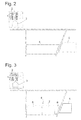
- Fig. 3 shows an example of a division of the fields 4, 5 in partial areas.
- the large field 4 is divided into three partial surfaces 6, 7, 8; the smaller field 5 remains uninterrupted, since its surface area is smaller than the area that can be worked by a combine harvester 1 in the intended period of use and the use of several combine harvester 1 therefore does not appear necessary.
- Other criteria that may be considered in the fractionation into sub-areas are expected local distributions of quality determining properties of the crop, such as moisture, degree of ripeness, purity, etc.
- Such data may be collected by a user through pre-inspection of the field prior to harvesting and entered manually the system will be entered; Preferably, their extraction takes place automatically, for example by evaluating high-resolution aerial or satellite images of the plant population on the fields 4, 5 or by reference of corresponding spatially resolved quality-relevant data collected in the same fields by previous harvesting operations from a combine used there and transmitted to the host computer.
- Such data which are collected again in the implementation of the planned harvesting operation, can, as mentioned above, be transmitted by radio in real time to the host computer;
- a corresponding division into partial surfaces 6, 7, 8 can also take place taking into account, for example, the moisture content of the crop.
- a combine harvester 1 can receive dry crops on the subarea 6, which can then be stored directly or processed further, while at the same time a second combine harvester 1 picks up moist crops on the subarea 7, which require drying before storage or further processing. This reduces the total amount of crop to be dried and, accordingly, reduces the cost of drying.
- the geometry of the fields is a criterion that can be taken into account when dividing into partial areas. So is in the Fig. 3 In the case shown, the division of the field 4 is carried out such that two partial surfaces 6, 7 of substantially rectangular shape and a substantially triangular partial surface 8 are obtained.
- the partial area 8 which is relatively difficult to be harvested due to its shape, together with the field 5 to a smaller, more agile combine harvester than the partial areas 6, 7.
- each combine harvester 1 needs to process its assigned partial surfaces and to travel from one partial surface to the next, when its grain tank will be full and emptied and how long field transporters and road vans need to transport the contents of the tank. It may turn out that for lack of available transport capacity one or the other combine harvester 1 can not be unloaded at short notice, or that for lack of sufficient harvesting capacity of the combine harvester 1, the transport vehicles 2 can not be utilized sufficiently continuously. If this is the case for a subdivision, it is discarded and a new one tried.
- step S3 If no appropriate subarray is found, either because it does not exist or because it is not found in a finite amount of available computation time, then it is determined in step S3, and the process returns to step S1 to set the defaults there to change so that they are easier to fulfill, for example by extending the time window or by increasing the number of machines 1, 2 intended for use.
- step S3 If it is determined in step S3 that a partial area distribution found in S2 is compatible with the specifications of the rough planning S1, the method proceeds to step S4, in which the paths 9 to be traveled on each partial area which are used to travel the paths 9 including turning maneuvers time required and the resulting times of completion of the grain tank for each combine 1, locations 10 and times of encounter of each combine with a field transporter, the paths of the field transporters and resultant Departure times of the road vans 2 of the fields, their ways to the bases 3 and from there to a next field, where they are needed, are calculated in advance.
- step S4 it is first checked whether a further decomposition of the partial surfaces in lower surfaces makes sense. This is the case in particular when a partial surface is large enough to fill the grain tank of the combine harvester 1 assigned to this partial surface several times with the harvested crop expected thereon, and / or when a quality-relevant parameter of the crop on the partial surface is variable depending on location. In the latter case, the division of the sub-area into sub-areas such as 6a, 6b, 6c or 7a, 7b in Fig. 4 made so that in a lower surface crop of on average high quality, ie z. B. well-matured or well-dry crop and another crop surface of lower average quality, so for example less ripe or moist crop is pending. The determination of the sub-surfaces is then followed by the determination of the order of their processing and finally the calculation of the paths of the combine harvester 1 on each sub-surface and between the sub-surfaces to be processed one after the other.
- step S4 the case may arise that the determinations made in the preceding planning step S2 prove to be impractical, e.g. because in the detailed determination of the routes 9 in step S4 for at least one of the combine harvester 1 no route is found that this - taking into account any downtime in which to wait for a transport vehicle to overload - can depart within the specified time window.
- Such incompatibility is detected in step S5 and causes the method to return to step S2.
- step S5 If it is determined before the beginning of the harvesting operation in step S5 that there is no incompatibility or that step S4 has been carried out successfully, then there is a complete mission planning, which specifies for each involved vehicle in detail the paths 9 to be traveled and the times which it should be at certain points of these routes such as a field access, an overload point 10, etc.
- combine sensors continuously record crop characteristics that have been used in the previous resource planning, such as area yield, crop moisture, etc. These recorded values are consistent with those used in the planning compared to expected values.
- the data acquired at the combines 1 can be transmitted in real time to the master computer, or the on-board computers of the combine 1 can carry a set of the expected values and, from time to time, a possible deviation between the carried and the newly measured values to the master computer. The latter uses the recorded deviations in real time to decide whether the deviation is so significant that it necessitates an adjustment of the planning.
- Such an adaptation may e.g. become necessary when a combine harvester detects an undesirably high moisture value of the crop during the processing of a lower surface, which deviates from a value assumed in the planning phase in the determination of the partial and / or lower surfaces.
- an attempt is first made to solve the problem by changing the processing order of the lower surfaces. Processing of the undersurface too moist is postponed to give it the opportunity to dry, and the processing of the other sub-surfaces is brought forward in time.
- step S4 Another reason for a change in the planned procedure may be that during the processing of a sub-area, its area yield turns out to be higher than expected.
- the method first returns to step S4 to reschedule the times of transfer from the combine harvester operating on the sub-surface to the transporter 2. If this succeeds, without overstraining the transport capacity of the transporter (s) 2, the harvesting operation continues with the overload times and locations changed in this manner.
- step S4 the attempt to redefine the overload times and locations by repeating step S4 must fail because the required transporters 2 can not return in time to the next required overload point. This is detected in step S5 and causes the process to return to step S2.
- step S2 In order to limit the computational effort, it is first possible to attempt to solve the transport problem by maintaining the partial areas defined in an earlier execution of step S2 and only changing the order of their processing when repeating step S2. For example, while a combine harvester is processing the unexpectedly high-yielding subarea, a second is redirected to one of its assigned subareas at short notice, whose area yield is known to be relatively low. Only when this fails (which can be determined quickly due to the relatively small number of alternatives to be investigated) is an attempt to redefine the subareas. If this attempt also fails, the method returns via step S3 to step S1, where, if available, additional Machines are shut down for use or the planned processing time is extended. Subsequently, the planning steps S2, S4 are repeated based on the specifications thus changed.
- the master computer can also react to any other deviations of this current harvesting operation from the planned sequence.
- position data of the participating machines being continuously reported to the master computer, the latter can at any time detect how far the position of the individual machines deviates from that intended for them in the current planning and whether the deviation necessitates any adjustments to the planning.
- an attempt is first made to compensate for the deviation by redesigning the routes to be traveled and the overload times and locations. If this is not successful, the method in the planning hierarchy goes back to step S2 and attempts to redefine the sub-surfaces. Only when this fails, is a further stage, S1, reduced, and the fundamental determinations of planning such as time window and number of machines are called into question.
Abstract
Description
Die vorliegende Erfindung betrifft ein Verfahren zur Steuerung eines Einsatzes von fahrbaren landwirtschaftlichen Maschinen auf einer von den Maschinen zu bearbeitenden Fläche wie etwa eines Ernte- oder Aussaateinsatzes oder der Ausbringung von Hilfsstoffen wie Dünger oder Pflanzenschutzmittel.The present invention relates to a method for controlling an application of mobile agricultural machines on a surface to be machined by the machines, such as a harvesting or Aussaateinsatzes or the application of excipients such as fertilizer or pesticides.
Aus
Aus
Es liegt auf der Hand, dass die unter Gesichtspunkten der Wirtschaftlichkeit und des rationellen Einsatzes von Ressourcen optimierte Planung eines Einsatzes um so aufwändiger ist, je größer die Zahl der daran beteiligten und ggf. miteinander inter-agierenden Maschinen ist. Es besteht daher Bedarf nach einer Technik, die eine Planung von umfangreicheren Einsätzen in der Landwirtschaft, insbesondere unter Beteiligung mehrerer Maschinen, unterstützt.It is obvious that the planning of an operation, which has been optimized in terms of economic efficiency and the rational use of resources, is the more complex the larger the number of participating and, if necessary, inter-interacting machines. There is therefore a need for a technique that supports planning for more extensive operations in agriculture, particularly involving multiple machines.
Die Aufgabe wird gelöst durch ein Verfahren zur Steuerung eines Einsatzes von fahrbaren landwirtschaftlichen Maschinen auf einer Fläche mit wenigstens drei aufeinander aufbauenden Schritten der Planung des Einsatzes, wobei im zweiten und dritten Planungsschritt jeweils Festlegungen des vorhergehenden Schritts verfeinert werden, und einem Schritt des Ausführens des Einsatzes entsprechend dem in den Planungsschritten geplanten Ablauf, wobei in dem Ausführungsschritt der Ablauf des Einsatzes überwacht und mit den in den Planungsschritten getroffenen Festlegungen verglichen wird und im Falle einer signifikanten Abweichung von den getroffenen Festlegungen wenigstens einer der Planungsschritte unter Berücksichtigung des Standes der Bearbeitung der Fläche wiederholt wird.The object is achieved by a method for controlling an application of mobile agricultural machines on an area with at least three successive stages of planning the mission, wherein in the second and third planning step, respectively, definitions of the previous step are refined, and a step of executing the mission in accordance with the procedure planned in the planning steps, wherein in the execution step the progress of the mission is monitored and compared with the determinations made in the planning steps and repeated in case of a significant deviation from the stipulations of at least one of the planning steps taking into account the state of the processing of the area becomes.
Der hierarchische Aufbau der Planungsstufe des Verfahrens mit aufeinander aufbauenden Planungsschritten ermöglicht eine einfache Erweiterung des Verfahrens zur Berücksichtigung einer großen Zahl von veränderbaren Parametern, zu denen auch die Anzahl der am Einsatz beteiligten Fahrzeuge gehören kann. Die fortlaufende Überwachung des Einsatzablaufs auf Übereinstimmung mit den bei der Planung getroffenen Festlegungen ermöglicht die Berücksichtigung eines unvorhergesehenen Ereignisses.The hierarchical structure of the planning stage of the method with successive planning steps allows a simple extension of the method for taking into account a large number of changeable parameters, which may include the number of vehicles involved in the use. The continuous monitoring of the operational sequence in accordance with the specifications made in the planning enables the consideration of an unforeseen event.
Wenn in jedem Planungsschritt wenigstens ein Merkmal des Einsatzes festgelegt wird, beruht die schrittweise Verfeinerung in den auf den ersten Planungsschritt folgenden Schritten vorzugsweise darin, jeweils wenigstens ein Merkmal des Einsatzes kompatibel zu jedem in einem früheren Planungsschritt festgelegten Merkmal des Einsatzes festzulegen. Wenn im Einsatz eine signifikante Abweichung von den getroffenen Festlegungen in einem der festgelegten Merkmale festgestellt wird, dann ist der wiederholte Planungsschritt zweckmäßigerweise derjenige, in dem das betreffende Merkmal festgelegt wurde. Wenn ein auf den Ergebnissen dieses wiederholten Planungsschritt aufbauender Planungsschritt existiert, wird dessen Wiederholung meist auch notwendig sein. Indem jedoch die Festlegungen der vorhergehenden Planungsschritte normalerweise (Ausnahmen werden später noch beschrieben) unangetastet bleiben, kann der Verarbeitungsaufwand bei der Anpassung der Einsatzplanung an die beobachtete Abweichung bzw. das unvorhergesehene Ereignis minimiert werden.When at least one feature of the mission is determined in each planning step, the incremental refinement in the steps following the first planning step is preferably to define at least one feature of the mission compatible with each feature of the mission defined in an earlier planning step. If, in use, a significant deviation is found from the determinations made in one of the specified characteristics, then the repeated planning step is expediently the one in which the characteristic in question was determined. If a planning step based on the results of this repeated planning step exists, its repetition will usually also be necessary. However, by leaving the definitions of the previous planning steps untouched (exceptions will be described later), the processing effort in adapting the scheduling to the observed deviation or event can be minimized.
Vorzugsweise erfolgt in wenigstens einem der Planungsschritte die Festlegung eines Merkmals anhand eines gemutmaßten Parameters der zu bearbeitenden Fläche, während des Ausführens des Einsatzes wird der Parameter erfasst, und eine signifikante Abweichung des Merkmals wird angenommen, wenn die Abweichung zwischen gemutmaßtem und erfassten Parameter eine Grenze überschreitet.Preferably, in at least one of the planning steps, the determination of a feature is made on the basis of a presumed parameter of the surface to be worked, during the execution of the operation the parameter is detected, and a significant deviation of the feature is assumed if the deviation between the measured and sensed parameter exceeds a limit ,
Bei dem Parameter kann es sich um einen globalen Parameter der zu bearbeitenden Fläche, insbesondere eine Erntegutmenge handeln. Die gemutmaßte Erntegutmenge kann dann in einem oder mehreren Planungsschritten herangezogen werden, um Merkmale wie etwa die Dauer des Einsatzes, die Zahl der daran beteiligten Maschinen etc. festzulegen.The parameter may be a global parameter of the area to be worked, in particular a crop quantity. The estimated crop quantity can then be used in one or more planning steps to define characteristics such as the duration of the operation, the number of machines involved, etc.
Um eine signifikante Abweichung des festgelegten Merkmals festzustellen, ist es zweckmäßig, den globalen Parameter aus im Laufe der Bearbeitung der Fläche gewonnen Daten zu extrapolieren, zum Beispiel indem die zu erwartende Gesamterntemenge aus dem zu einem gegebenen Zeitpunkt abgeernteten Bruchteil der Fläche und der eingebrachten Erntemenge hochgerechnet wird. Wenn der hochgerechnete Wert über dem ursprünglich gemutmaßten liegt, kann es erforderlich sein, die geplante Dauer des Einsatzes zu verlängern oder die Zahl der eingesetzten Maschinen zu erhöhen.In order to determine a significant deviation of the specified feature, it is expedient to extrapolate the global parameter from data obtained during the processing of the area, for example by extrapolating the total expected harvest quantity from the fraction of the area harvested and the harvest yielded at a given time becomes. If the projected value is higher than originally estimated, it may be necessary to extend the planned duration of the mission or increase the number of machines used.
Der gemutmaßte bzw. erfasste Parameter kann auch ein ortsabhängiger Parameter der zu bearbeitenden Fläche sein, wie etwa Flächenertrag, Reifegrad, Feuchtegehalt oder Sortenreinheit des Ernteguts, die auf der zu bearbeitenden Fläche ortsabhängig unterschiedlich sein können. Wenn die zu bearbeitende Fläche Teilflächen unterschiedlicher Qualität umfasst, liegt auf der Hand, dass durch Berücksichtigung des von Ort zu Ort veränderlichen Flächenertrags eine genauere Hochrechnung der zu erwartenden Gesamterntemenge im Laufe der Bearbeitung möglich ist, als wenn ortsabhängige Schwankungen des Flächenertrages unberücksichtigt bleiben. Die hierfür benötigten großen Mengen ortsabhängiger Daten können insbesondere bei einer früheren Bearbeitung derselben Fläche gewonnen sein.The assumed or detected parameter can also be a location-dependent parameter of the surface to be processed, such as area yield, degree of maturity, Moisture content or variety purity of the crop, which may vary depending on the location on the surface to be processed. If the area to be worked on comprises subareas of different quality, it is obvious that by taking account of the variable area yield from place to place a more precise extrapolation of the expected total harvest quantity during processing is possible than if location-dependent fluctuations in area yield are disregarded. The large quantities of location-dependent data required for this purpose can be obtained in particular in the case of an earlier processing of the same area.
Die Berücksichtigung von ortsabhängigen, auf die Qualität des Ernteguts bezogenen Parametern wie Reifegrad, Feuchtegehalt und Sortenreinheit ermöglicht es, einen Ernteeinsatz so zu planen, dass mehrere Maschinen parallel oder eine Maschine jeweils sukzessive mehrere qualitativ unterschiedliche Chargen von Erntegut gewinnt, die später getrennt voneinander verarbeitet bzw. vermarktet werden können.The consideration of location - dependent parameters related to the quality of the crop, such as degree of ripeness, moisture content and varietal purity makes it possible to plan a harvesting operation in such a way that several machines in parallel or one machine successively obtains several qualitatively different batches of crops, which are later processed separately from one another can be marketed.
Wenn die Wiederholung des Planungsschrittes, in dem das Merkmal festgelegt wurde, bei dem die signifikante Abweichung festgestellt worden ist, scheitert, wird zweckmäßigerweise ein dem gescheiterten Planungsschritt vorangehender Planungsschritt wiederholt wird. Dadurch wird die Möglichkeit geschaffen, die Festlegungen dieses Schrittes abzuwandeln und zu einer Festlegung zu gelangen, die die erfolgreiche Durchführung des gescheiterten Schritts ermöglicht.When the repetition of the planning step in which the feature where the significant deviation has been determined fails, it is convenient to repeat a planning step preceding the failed planning step. This creates the opportunity to modify the definitions of this step and to arrive at a determination that allows the successful completion of the failed step.
Zu den in einem oder mehreren frühen Planungsschritten zu treffenden Festlegungen gehören vorzugsweise die Dauer des Einsatzes, die Zahl der an dem Einsatz beteiligten Maschinen sowie gegebenenfalls die Zahl von Versorgungsfahrzeugen für den Transport von Material zwischen den Maschinen und wenigstens einem Stützpunkt.The determinations to be made in one or more early planning steps preferably include the duration of the mission, the number of machines involved in the deployment, and, optionally, the number of supply vehicles for transporting material between the machines and at least one support point.
In einem oder mehreren späten Planungsschritten erfolgt vorzugsweise eine Aufteilung der zu bearbeitenden Fläche in jeweils einer der Maschinen zur Bearbeitung zugewiesene Teilflächen.In one or more late planning steps, it is preferable to divide the area to be worked into sub-areas assigned in each case to one of the machines for processing.
Auf den Schritt der Aufteilung in Teilflächen folgt vorzugsweise ein Planungsschritt, in dem für jede Maschine auf der ihr zugewiesenen Teilfläche eine Fahrtroute festgelegt wird, das heißt bei dem diese Fahrtroute das in dem betreffenden Planungsschritt festgelegte Merkmal ist.The step of subdivision into subareas is preferably followed by a planning step in which a travel route is defined for each machine on the subarea assigned to it, that is to say in which this route is the characteristic specified in the relevant planning step.
Dieser Planungsschritt kann wiederum zweckmäßigerweise unterteilt werden in das Zerlegen der jeweils einer Maschine zur Bearbeitung zugewiesenen Teilfläche in Unterflächen, das Festlegen der Bearbeitungsreihenfolge der Unterflächen und das Festlegen der von der Maschine abzufahrenden Route auf jeder Unterfläche.This planning step, in turn, may be conveniently divided into disassembling the subarea in subareas assigned to each machine for processing, specifying the processing order of the subareas, and specifying the route to be traveled by the machine on each subarea.
Falls sich während des Einsatzes herausstellt, dass der Planungsschritt des Zerlegens, Festlegens der Reihenfolge und der Fahrtroute wiederholt werden muss, wird zunächst versucht, unter Beibehaltung der zuvor festgelegten Unterflächen und Fahrtrouten nur die Reihenfolge, in der die Unterflächen bearbeitet werden, neu festzulegen. Dies ist besonders dann zweckmäßig, wenn der Parameter die Feuchtigkeit des Ernteguts ist, denn diese kann sich im Laufe des Einsatzes merklich ändern. Wenn zum Beispiel beim Abernten einer Unterfläche das dort anstehende Erntegut sich als feuchter als ursprünglich gemutmaßt erweist, kann es genügen, die Bearbeitung dieser Unterfläche zurückzustellen und zunächst andere Unterflächen zu bearbeiten, während das Erntegut auf der zurückgestellten Unterfläche von der Sonne getrocknet wird.If it turns out during the operation that the planning step of disassembling, setting the order and the route has to be repeated, an attempt is made, while maintaining the previously defined sub-areas and routes only redefine the order in which the sub-surfaces are edited. This is particularly useful if the parameter is the moisture of the crop, because this can change significantly in the course of use. If, for example, when harvesting a lower surface, the crop standing there proves to be wetter than originally speculated, it may be sufficient to postpone the processing of this lower surface and to first work on other lower surfaces while the crop is being dried on the returned lower surface by the sun.
Weitere Merkmale und Vorteile der Erfindung ergeben sich aus der nachfolgenden Beschreibung von Ausführungsbeispielen unter Bezugnahme auf die beigefügten Figuren.
- Fig. 1
- zeigt ein schematisches Flussdiagramm des erfindungsgemäßen Verfahrens; und
- Fig. 2-5
- veranschaulichen den Ablauf des Verfahrens anhand von Kartendarstellungen.
- Fig. 1
- shows a schematic flow diagram of the method according to the invention; and
- Fig. 2-5
- illustrate the process of the method based on map representations.
Das Verfahren wird im Wesentlichen ausgeführt auf einem Leitrechner, der stationär oder auf einem der in
Als Beispiel für einen mit dem erfindungsgemäßen Verfahren gesteuerten Einsatz soll im Folgenden ein Ernteeinsatz betrachtet werden. Bei den beteiligten Fahrzeugen 1, 2 kann es sich um Erntemaschinen 1 und Transportfahrzeuge 2 eines einzelnen Landwirts, genossenschaftlich genutzte Fahrzeuge oder die Fahrzeuge eines Lohnunternehmers handeln, der Ernteeinsätze im Auftrag von Landwirten abwickelt. Die Fahrzeuge umfassen insbesondere mehrere Mähdrescher 1, die sich in technischen Eigenschaften wie etwa der Breite ihres Erntevorsatzes, ihrer maximalen Geschwindigkeit im Ernteeinsatz oder ihrer Korntankkapazität unterscheiden können, mehrere Straßentransporter 2 zur Beförderung des Ernteguts vom Feld zum Einlager- oder Verarbeitungsplatz, die sich ebenfalls in technischen Eigenschaften wie Geschwindigkeit und Zuladung unterscheiden können, sowie gegebenenfalls einen oder mehrere Feldtransporter für die Beförderung des Ernteguts von den Mähdreschern 1 zu den Straßentransportern 2.As an example of an application controlled by the method according to the invention, a harvesting operation will be considered below. The involved
Vorgaben, von denen das Verfahren ausgeht, sind zunächst Lage und Größe der in
Die Abschätzung des Fahrzeugbedarfs kann zum Beispiel basierend auf einer Berechnung der Fahrzeiten der Mähdrescher 1 zu den Feldern und der anhand der Gesamterntemenge und der Verarbeitungskapazität der Mähdrescher 1 abgeschätzten Dauer der Feldbearbeitung erfolgen. Um die Fahrzeiten der Mähdrescher 1 realistisch abschätzen zu können, umfasst dieser Schritt gleichzeitig für jeden Mähdrescher 1 die Festlegung, auf welchen der mehreren, gegebenenfalls örtlich voneinander getrennten Felder 4, 5 der Mähdrescher 1 arbeiten soll, und in welcher Reihenfolge dies zu geschehen hat. Dabei können auch mehrere Mähdrescher 1 zum gleichzeitigen Einsatz auf einem Feld 4 eingeplant werden.The estimation of the vehicle demand may for example be based on a calculation of the travel times of the
Die Grobplanung des Schritts S1 kann lange Zeit vor dem tatsächlichen Ernteeinsatz stattfinden, so dass der ungefähre Bedarf an Maschinen und Personal für den Ernteeinsatz langfristig im Voraus bekannt ist und gegebenenfalls die Verfügbarkeit von Personal dem Bedarf entsprechend beeinflusst werden kann.The rough planning of step S1 can take place long before the actual harvesting operation, so that the approximate demand for harvesting machinery and personnel is known in advance in a long term, and if necessary, the availability of personnel can be influenced as needed.
Eine langfristig im Voraus durchgeführte Grobplanung kann sich als unzweckmäßig erweisen, wenn wenige Tage vor dem geplanten Einsatz ein Wetterbericht für den Einsatzzeitraum zur Verfügung steht. Der Wetterbericht kann insbesondere dazu führen, dass das ursprünglich für den Ernteeinsatz vorgesehene Zeitfenster sich erheblich verkürzt, weil die Ernte vor einem in dem Wetterbericht angekündigten Niederschlag eingebracht werden muss. In diesem Fall überprüft der Leitrechner, ob die zuvor getroffene Festlegung der Zahl der beteiligten Fahrzeuge 1, 2 noch mit dem, verkürzten Zeitfenster kompatibel ist, oder ob die Zahl der Fahrzeuge erhöht werden muss, um die Ernte rechtzeitig einzubringen. Wenn letzteres der Fall ist, muss die gesamte Grobplanung S1 wiederholt werden, und auch eventuell bereits ausgeführte, auf dieser Grobplanung basierende weitere Planungsschritte werden verworfen.A long-term advance rough planning may prove inappropriate if a weather report is available for the operational period a few days before the scheduled deployment. In particular, the weather report may result in the time window originally provided for the harvesting operation being considerably shortened because the harvest must be brought before a precipitation announced in the weather report. In this case, the host computer checks whether the previously made determination of the number of participating
Wenn die Grobplanung S1 erfolgreich durchlaufen worden ist, d.h. wenn die Abschätzung ergibt, dass die Ernte mit den vorgesehenen Fahrzeugen in der vorgesehenen Zeit einbringbar sein sollte, schließt sich ein Schritt S2 der Feldplanung S2 an. Basierend auf geografischen Daten, die den Randverlauf des Feldes, Zufahrten zum Feld sowie Wege zwischen den Zufahrten und den Verarbeitungs- oder Sammelpunkten beschreiben, wird jedes Feld in Teilflächen unterteilt, die jeweils einem einzigen Mähdrescher zur Bearbeitung zugewiesen werden. Um eine effiziente Bearbeitung des gesamten Feldes zu ermöglichen, erfolgt die Aufteilung in Teilflächen derart, dass die Wege, die der Feldtransporter zur Beförderung von Erntegut von den Mähdreschern 1 zu den Straßentransportern 2 zurückzulegen hat, oder die, wenn kein Feldtransporter verwendet wird, die Straßentransporter 2 auf den Feldern fahren müssen, möglichst kurz werden und auch die Straßentransporter 2 den Stützpunkt 3 oder eventuell mehrere verschiedene Stützpunkte 3 schnell erreichen können.If the rough planning S1 has been successfully completed, ie if the estimation shows that the harvest with the intended vehicles should be able to be brought in within the designated time, a step S2 follows the field planning S2. Based on geographic data showing the edge of the field, driveways to the field and paths between the driveways and the processing or collection points Each field is subdivided into faces, each assigned to a single combine for processing. In order to enable efficient processing of the entire field, the division into sub-areas is carried out in such a way that the paths the field transporter has to cover for transporting crops from the
Weitere Kriterien, die bei der Zerlegung in Teilflächen berücksichtigt werden können, sind erwartete örtliche Verteilungen von qualitätsbestimmenden Eigenschaften des Ernteguts wie etwa Feuchte, Reifegrad, Reinheit, etc. Derartige Daten können von einem Benutzer durch eine Vorabinspektion des Feldes vor dem Ernteeinsatz erfasst und manuell in das System eingegeben werden; vorzugsweise erfolgt ihre Gewinnung automatisch, zum Beispiel durch Auswertung hoch auflösender Luft- oder Satellitenbilder des Pflanzenbestandes auf den Feldern 4, 5 oder anhand von entsprechenden ortsaufgelösten qualitätsrelevanten Daten, die im Rahmen früherer Ernteeinsätze auf den gleichen Feldern von einem dort eingesetzten Mähdrescher erfasst und an den Leitrechner übermittelt worden sind. Derartige Daten, die auch bei der Durchführung des geplanten Ernteeinsatzes von neuem erhoben werden, können, wie eingangs erwähnt, per Funk in Echtzeit an den Leitrechner übermittelt werden; denkbar ist aber auch, zur Minimierung des Funk-Datenverkehrs nur einzelne im Folgenden noch genauer erläuterte Daten in Echtzeit an den Leitrechner zu übermitteln und die Gesamtheit der ortsaufgelösten Daten auf einem Datenträger des Bordrechners des Mähdreschers zwischenzuspeichern und sie von dort nach Abschluss des Ernteeinsatzes auf den Leitrechner zu überspielen, damit sie diesem für die Planung eines zukünftigen Einsatzes zur Verfügung stehen.Other criteria that may be considered in the fractionation into sub-areas are expected local distributions of quality determining properties of the crop, such as moisture, degree of ripeness, purity, etc. Such data may be collected by a user through pre-inspection of the field prior to harvesting and entered manually the system will be entered; Preferably, their extraction takes place automatically, for example by evaluating high-resolution aerial or satellite images of the plant population on the
Aus diesen ortsaufgelösten Daten kann sich beispielsweise ergeben, dass der Reifegrad des Ernteguts auf einer durch Klima oder Bodenqualität benachteiligten Teilfläche des Feldes 4, beispielsweise dem Nordhang eines Hügels, schlechter ist als auf einer bevorzugten, besser besonnten Teilfläche, so dass es zweckmäßig ist, diese Teilflächen von verschiedenen Mähdreschern bearbeiten zu lassen, so dass, anstatt Erntegut unterschiedlicher Reifegrade zu mischen, ein Mähdrescher nur hochwertiges, gut ausgereiftes Erntegut sammelt, während weniger ausgereiftes Erntegut, das eventuell eine geringere Wertigkeit besitzt oder auch nur nach der Ernte anders behandelt werden muss, von einem zweiten Mähdrescher geerntet wird oder seine Ernte gar auf einen späteren Zeitpunkt verschoben wird.From these spatially resolved data, it may be found, for example, that the degree of ripeness of the crop on a sub-area of the field 4 disadvantaged by climate or soil quality, for example the northern slope of a hill, is worse than on a preferred, better sunnaded sub-area, so that it is expedient to do so Having crops processed by different combine harvesters so that instead of blending crops of different ripeness levels, a combine collects only high quality, well-matured crops, while less mature crops, which may have lower valence or need to be treated differently after harvest, from a second harvester harvest or postpone its harvest to a later date.
Eine entsprechende Aufteilung in Teilflächen 6, 7, 8 kann auch unter Berücksichtigung beispielsweise des Feuchtegrads des Ernteguts erfolgen. So kann etwa ein Mähdrescher 1 auf der Teilfläche 6 trockenes Erntegut aufnehmen, das anschließend direkt gelagert oder weiter verarbeitet werden kann, während gleichzeitig ein zweiter Mähdrescher 1 feuchtes Erntegut auf der Teilfläche 7 aufnimmt, das vor der Lagerung oder Weiterverarbeitung einer Trocknung bedarf. So verringert sich die Gesamtmenge an zu trocknendem Erntegut, und dementsprechend verringern sich auch die Kosten der Trocknung.A corresponding division into
Auch die Geometrie der Felder ist ein Kriterium, das bei der Aufteilung in Teilflächen berücksichtigt werden kann. So ist im in
Anhand der Festlegung der Teilflächen 6, 7, 8 kann abgeschätzt werden, wie lange jeder Mähdrescher 1 zur Bearbeitung der ihm zugewiesenen Teilflächen und zum Fahren von einer Teilfläche zur nächsten braucht, wann sein Korntank voll sein wird und entleert werden muss und wie lange Feldtransporter und Straßentransporter zum Weiterbefördern des Tankinhalts benötigen. Dabei kann sich herausstellen, dass mangels verfügbarer Transportkapazität der eine oder andere Mähdrescher 1 nicht kurzfristig entladen werden kann, oder dass mangels ausreichender Erntekapazität der Mähdrescher 1 die Transportfahrzeuge 2 nicht hinreichend kontinuierlich ausgelastet werden können. Wenn dies für eine Teilflächenaufteilung der Fall ist, wird sie verworfen und eine neue ausprobiert.On the basis of the definition of the
Falls keine geeignete Teilflächenaufteilung gefunden wird, sei es weil sie nicht existiert oder weil sie in einer begrenzten zur Verfügung stehenden Rechenzeit nicht gefunden wird, so wird dies in Schritt S3 festgestellt, und das Verfahren kehrt zurück zu Schritt S1, um die dort getroffenen Vorgaben so zu ändern, dass sie leichter erfüllbar sind, zum Beispiel durch Verlängern des Zeitfensters oder durch Erhöhen der Zahl der für den Einsatz vorgesehenen Maschinen 1, 2.If no appropriate subarray is found, either because it does not exist or because it is not found in a finite amount of available computation time, then it is determined in step S3, and the process returns to step S1 to set the defaults there to change so that they are easier to fulfill, for example by extending the time window or by increasing the number of
Wenn in Schritt S3 festgestellt wird, dass eine in S2 gefundene Teilflächenaufteilung mit den Vorgaben der Grobplanung S1 vereinbar ist, so geht das Verfahren über zu Schritt S4, in welchem die abzufahrenden Wege 9 auf jeder Teilfläche, die zum Abfahren der Wege 9 einschließlich von Wendemanövern benötigte Zeit und die daraus resultierenden Zeitpunkte des Vollwerdens des Korntanks für jeden Mähdrescher 1, Orte 10 und Zeiten des Zusammentreffens jedes Mähdreschers mit einem Feldtransporter, die Wege der Feldtransporter und daraus resultierende Abfahrtzeiten der Straßentransporter 2 von den Feldern, ihre Wege zu den Stützpunkten 3 sowie von dort zu einem nächsten Feld, wo sie benötigt werden, vorausberechnet werden.If it is determined in step S3 that a partial area distribution found in S2 is compatible with the specifications of the rough planning S1, the method proceeds to step S4, in which the
Im Rahmen des Schritts S4 wird zunächst überprüft, ob eine weitere Zerlegung der Teilflächen in Unterflächen sinnvoll ist. Dies ist insbesondere dann der Fall, wenn eine Teilfläche groß genug ist, um mit dem darauf erwarteten Erntegut den Korntank des dieser Teilfläche zugewiesenen Mähdreschers 1 mehrmals zu füllen, und/oder wenn ein qualitätsrelevanter Parameter des Ernteguts auf der Teilfläche ortsabhängig variabel ist. In letzterem Fall wird die Zerlegung der Teilfläche in Unterflächen wie etwa 6a, 6b, 6c oder 7a, 7b in
Für die Prognose des zeitabhängigen Füllstands des Korntanks eines Mähdreschers 1 werden ortsauflösende Daten über den Flächenertrag der Felder herangezogen, die in vorhergehenden Ernteeinsätzen von den Mähdreschern gewonnen worden sind.For the forecast of the time-dependent filling level of the grain tank of a
Ein Beispiel für das Ergebnis einer solchen Planung, die festgelegten Wege 9 und die Überladestellen 10, ist in
Auch im Planungsschritt S4 kann der Fall eintreten, dass die im vorhergehenden Planungsschritt S2 getroffenen Festlegungen sich als nicht praktikabel erweisen, z.B. weil bei der detaillierten Festlegung der Fahrtrouten 9 in Schritt S4 für wenigstens einen der Mähdrescher 1 keine Route gefunden wird, die dieser - unter Berücksichtigung eventueller Stillstandszeiten, in denen auf ein Transportfahrzeug zum Überladen gewartet werden muss - innerhalb des vorgegebenen Zeitfensters abfahren kann. Eine solche Inkompatibilität wird in Schritt S5 erkannt und führt dazu, dass das Verfahren zu Schritt S2 zurückkehrt.Also in the planning step S4, the case may arise that the determinations made in the preceding planning step S2 prove to be impractical, e.g. because in the detailed determination of the
Wenn vor Beginn des Ernteeinsatzes in Schritt S5 festgestellt wird, dass keine Inkompatibilität vorliegt bzw. dass der Schritt S4 erfolgreich ausgeführt worden ist, dann liegt eine vollständige Einsatzplanung vor, die für jedes beteiligte Fahrzeug im Einzelnen die zurückzulegenden Wege 9 und die Zeiten angibt, zu denen es sich an bestimmten Punkten dieser Wege wie etwa einer Feldzufahrt, einer Überladestelle 10, etc. befinden soll.If it is determined before the beginning of the harvesting operation in step S5 that there is no incompatibility or that step S4 has been carried out successfully, then there is a complete mission planning, which specifies for each involved vehicle in detail the
Während des Ernteeinsatzes erfassen Sensoren der Mähdrescher fortlaufend Eigenschaften des Ernteguts, die bei der vorhergehenden Einsatzplanung zugrunde gelegt worden sind, wie etwa Flächenertrag, Feuchtigkeit des Ernteguts etc. Diese erfassten Werte werden mit den der Planung zugrunde gelegten erwarteten Werten verglichen. Zu diesem Zweck können die an den Mähdreschern 1 erfassten Daten in Echtzeit an den Leitrechner übermittelt werden, oder die Bordrechner der Mähdrescher 1 können einen Satz der erwarteten Werte mit sich führen und von Zeit zu Zeit eine eventuelle Abweichung zwischen den mitgeführten und den neu gemessenen Werten an den Leitrechner übermitteln. Letzterer entscheidet anhand der erfassten Abweichungen in Echtzeit, ob die Abweichung so signifikant ist, dass sie eine Anpassung der Planung erforderlich macht.During harvesting, combine sensors continuously record crop characteristics that have been used in the previous resource planning, such as area yield, crop moisture, etc. These recorded values are consistent with those used in the planning compared to expected values. For this purpose, the data acquired at the
Eine solche Anpassung kann z.B. nötig werden, wenn ein Mähdrescher während der Bearbeitung einer Unterfläche einen unerwünscht hohen Feuchtewert des Ernteguts feststellt, der von einem in der Planungsphase bei der Festlegung der Teil- und/oder Unterflächen angenommenen Wert abweicht. In diesem Fall wird zunächst versucht, über eine Änderung der Bearbeitungsreihenfolge der Unterflächen das Problem zu lösen. Die Bearbeitung der zu feuchten Unterfläche wird zurückgestellt, um ihr Gelegenheit zum Trocknen zu geben, und die Bearbeitung der anderen Unterflächen wird zeitlich vorgezogen.Such an adaptation may e.g. become necessary when a combine harvester detects an undesirably high moisture value of the crop during the processing of a lower surface, which deviates from a value assumed in the planning phase in the determination of the partial and / or lower surfaces. In this case, an attempt is first made to solve the problem by changing the processing order of the lower surfaces. Processing of the undersurface too moist is postponed to give it the opportunity to dry, and the processing of the other sub-surfaces is brought forward in time.
Ein weiterer Anlass für eine Änderung des geplanten Ablaufs kann sein, dass sich während der Bearbeitung einer Unterfläche deren Flächenertrag als höher als erwartet herausstellt. In diesem Fall kehrt das Verfahren zunächst zum Schritt S4 zurück, um die Zeitpunkte des Überladens von dem auf der betreffenden Unterfläche arbeitenden Mähdrescher auf den Transporter 2 neu zu planen. Wenn dies gelingt, ohne die Transportkapazität des oder der Transporter 2 zu überfordern, wird der Ernteeinsatz mit den in dieser Weise geänderten Überladezeiten und -orten fortgesetzt.Another reason for a change in the planned procedure may be that during the processing of a sub-area, its area yield turns out to be higher than expected. In this case, the method first returns to step S4 to reschedule the times of transfer from the combine harvester operating on the sub-surface to the
Ein höherer Flächenertrag kann jedoch auch dazu führen, dass die Transportkapazität der für den Ernteeinsatz abgestellten Transportfahrzeuge nicht mehr ausreicht. In diesem Fall muss der Versuch, die Überladezeiten und -orte durch Wiederholen des Schritts S4 neu festzulegen, scheitern, weil die benötigten Transporter 2 nicht rechtzeitig zum nächsten erforderlichen Überladeort zurückkehren können. Dies wird in Schritt S5 erkannt und führt dazu, dass das Verfahren zum Schritt S2 zurückkehrt.However, a higher area yield can also mean that the transport capacity of the transport vehicles parked for harvesting is no longer sufficient. In this case, the attempt to redefine the overload times and locations by repeating step S4 must fail because the required
Um den Rechenaufwand in Grenzen zu halten, kann zunächst versucht werden, das Transportproblem zu lösen, indem bei der Wiederholung des Schritts S2 die bei einer früheren Ausführung des Schritts S2 festgelegten Teilflächen beibehalten werden und lediglich die Reihenfolge ihrer Bearbeitung verändert wird. Beispielsweise wird, während ein Mähdrescher die unerwartet ertragreiche Teilfläche bearbeitet, ein zweiter kurzfristig auf eine der ihm zugewiesenen Teilflächen umdirigiert, deren Flächenertrag als relativ gering bekannt ist. Erst wenn dies misslingt (was aufgrund der relativ geringen Zahl von zu untersuchenden Alternativen schnell festgestellt werden kann), wird versucht, die Teilflächen neu festzulegen. Wenn auch dieser Versuch scheitert, kehrt das Verfahren über Schritt S3 zu Schritt S1 zurück, wo, sofern verfügbar, zusätzliche Maschinen für den Einsatz abgestellt werden oder die vorgesehene Bearbeitungszeit verlängert wird. Anschließend werden anhand der so geänderten Vorgaben die Planungsschritte S2, S4 wiederholt.In order to limit the computational effort, it is first possible to attempt to solve the transport problem by maintaining the partial areas defined in an earlier execution of step S2 and only changing the order of their processing when repeating step S2. For example, while a combine harvester is processing the unexpectedly high-yielding subarea, a second is redirected to one of its assigned subareas at short notice, whose area yield is known to be relatively low. Only when this fails (which can be determined quickly due to the relatively small number of alternatives to be investigated) is an attempt to redefine the subareas. If this attempt also fails, the method returns via step S3 to step S1, where, if available, additional Machines are shut down for use or the planned processing time is extended. Subsequently, the planning steps S2, S4 are repeated based on the specifications thus changed.
In analoger Weise wie auf von der Prognose abweichende Erntemengen oder unerwartet feuchtes Erntegut kann der Leitrechner auch auf beliebige andere Abweichungen dieses laufenden Ernteeinsatzes vom geplanten Ablauf reagieren. Indem zum Beispiel Positionsdaten der beteiligten Maschinen laufend an den Leitrechner gemeldet werden, kann dieser jederzeit erkennen, wie weit die Position der einzelnen Maschinen von der ihnen in der aktuellen Planung zugedachten abweicht und ob die Abweichung eventuelle Anpassungen der Planung erforderlich macht. Auch hier wird zunächst versucht, die Abweichung durch eine Neuplanung der zu fahrenden Wege und der Überladezeiten und -orte aufzufangen. Gelingt dies nicht, geht das Verfahren in der Planungshierarchie eine Stufe zurück zu Schritt S2 und versucht eine Neufestlegung der Unterflächen. Erst wenn auch dies scheitert, wird eine weitere Stufe, zu S1, zurückgegangen, und die fundamentalen Festlegungen der Planung wie Zeitfenster und Maschinenzahl werden in Frage gestellt.In an analogous way to harvesting quantities deviating from the prognosis or unexpectedly moist crops, the master computer can also react to any other deviations of this current harvesting operation from the planned sequence. By, for example, position data of the participating machines being continuously reported to the master computer, the latter can at any time detect how far the position of the individual machines deviates from that intended for them in the current planning and whether the deviation necessitates any adjustments to the planning. Again, an attempt is first made to compensate for the deviation by redesigning the routes to be traveled and the overload times and locations. If this is not successful, the method in the planning hierarchy goes back to step S2 and attempts to redefine the sub-surfaces. Only when this fails, is a further stage, S1, reduced, and the fundamental determinations of planning such as time window and number of machines are called into question.
- 11
- MähdrescherHarvester
- 22
- Transportfahrzeugtransport vehicle
- 33
- Stützpunktbase
- 44
- Feldfield
- 55
- Feldfield
- 66
- Teilflächesubarea
- 77
- Teilflächesubarea
- 88th
- Teilflächesubarea
- 99
Claims (13)
Applications Claiming Priority (1)
| Application Number | Priority Date | Filing Date | Title |
|---|---|---|---|
| DE102008050460A DE102008050460A1 (en) | 2008-10-08 | 2008-10-08 | Method for controlling the use of agricultural machines |
Publications (3)
| Publication Number | Publication Date |
|---|---|
| EP2174537A1 true EP2174537A1 (en) | 2010-04-14 |
| EP2174537B1 EP2174537B1 (en) | 2013-05-22 |
| EP2174537B2 EP2174537B2 (en) | 2022-11-16 |
Family
ID=41460959
Family Applications (1)
| Application Number | Title | Priority Date | Filing Date |
|---|---|---|---|
| EP09165934.2A Active EP2174537B2 (en) | 2008-10-08 | 2009-07-21 | Method for controlling the use of agricultural machines |
Country Status (2)
| Country | Link |
|---|---|
| EP (1) | EP2174537B2 (en) |
| DE (1) | DE102008050460A1 (en) |
Cited By (6)
| Publication number | Priority date | Publication date | Assignee | Title |
|---|---|---|---|---|
| DE102017201421A1 (en) | 2017-01-30 | 2018-08-02 | Deere & Company | Control arrangement for a grinding device and / or device for adjusting the position of a counter-blade of a forage harvester |
| DE102017103141A1 (en) | 2017-02-16 | 2018-08-16 | Amazonen-Werke H. Dreyer Gmbh & Co. Kg | Agricultural machine system and method for planning lanes for processing an agricultural area |
| EP3578032A1 (en) * | 2018-06-05 | 2019-12-11 | CLAAS Selbstfahrende Erntemaschinen GmbH | Method for controlling an agricultural harvesting programme |
| EP4270281A1 (en) | 2022-04-27 | 2023-11-01 | CLAAS E-Systems GmbH | Swarm assistance system for planning and controlling the use of at least one autonomous agricultural universal working machine |
| EP4270280A1 (en) | 2022-04-27 | 2023-11-01 | CLAAS E-Systems GmbH | Swarm assistance system for autonomous agricultural universal working machines |
| EP4268558A1 (en) * | 2022-04-27 | 2023-11-01 | CLAAS Selbstfahrende Erntemaschinen GmbH | Assistance system for generating route plans for autonomous agricultural machines |
Families Citing this family (34)
| Publication number | Priority date | Publication date | Assignee | Title |
|---|---|---|---|---|
| DE102011088700A1 (en) | 2011-12-15 | 2013-06-20 | Claas Selbstfahrende Erntemaschinen Gmbh | Method for planning a process chain for an agricultural labor input |
| DE102015108374A1 (en) | 2015-05-27 | 2016-12-01 | Claas Selbstfahrende Erntemaschinen Gmbh | Method for controlling a self-propelled harvesting machine |
| US11641800B2 (en) | 2020-02-06 | 2023-05-09 | Deere & Company | Agricultural harvesting machine with pre-emergence weed detection and mitigation system |
| US11653588B2 (en) | 2018-10-26 | 2023-05-23 | Deere & Company | Yield map generation and control system |
| US11079725B2 (en) | 2019-04-10 | 2021-08-03 | Deere & Company | Machine control using real-time model |
| US11178818B2 (en) | 2018-10-26 | 2021-11-23 | Deere & Company | Harvesting machine control system with fill level processing based on yield data |
| US11240961B2 (en) | 2018-10-26 | 2022-02-08 | Deere & Company | Controlling a harvesting machine based on a geo-spatial representation indicating where the harvesting machine is likely to reach capacity |
| US11589509B2 (en) | 2018-10-26 | 2023-02-28 | Deere & Company | Predictive machine characteristic map generation and control system |
| US11467605B2 (en) | 2019-04-10 | 2022-10-11 | Deere & Company | Zonal machine control |
| US11672203B2 (en) | 2018-10-26 | 2023-06-13 | Deere & Company | Predictive map generation and control |
| US11234366B2 (en) | 2019-04-10 | 2022-02-01 | Deere & Company | Image selection for machine control |
| US11778945B2 (en) | 2019-04-10 | 2023-10-10 | Deere & Company | Machine control using real-time model |
| US11477940B2 (en) | 2020-03-26 | 2022-10-25 | Deere & Company | Mobile work machine control based on zone parameter modification |
| CN111602484A (en) * | 2020-05-27 | 2020-09-01 | 吉林省林业科学研究院 | Method for improving saline-alkali soil by utilizing vegetation |
| US11849672B2 (en) | 2020-10-09 | 2023-12-26 | Deere & Company | Machine control using a predictive map |
| US11675354B2 (en) | 2020-10-09 | 2023-06-13 | Deere & Company | Machine control using a predictive map |
| US11727680B2 (en) | 2020-10-09 | 2023-08-15 | Deere & Company | Predictive map generation based on seeding characteristics and control |
| US11895948B2 (en) | 2020-10-09 | 2024-02-13 | Deere & Company | Predictive map generation and control based on soil properties |
| US11711995B2 (en) | 2020-10-09 | 2023-08-01 | Deere & Company | Machine control using a predictive map |
| US11474523B2 (en) | 2020-10-09 | 2022-10-18 | Deere & Company | Machine control using a predictive speed map |
| US11946747B2 (en) | 2020-10-09 | 2024-04-02 | Deere & Company | Crop constituent map generation and control system |
| US11871697B2 (en) | 2020-10-09 | 2024-01-16 | Deere & Company | Crop moisture map generation and control system |
| US11864483B2 (en) | 2020-10-09 | 2024-01-09 | Deere & Company | Predictive map generation and control system |
| US11889788B2 (en) | 2020-10-09 | 2024-02-06 | Deere & Company | Predictive biomass map generation and control |
| US11650587B2 (en) | 2020-10-09 | 2023-05-16 | Deere & Company | Predictive power map generation and control system |
| US11844311B2 (en) | 2020-10-09 | 2023-12-19 | Deere & Company | Machine control using a predictive map |
| US11592822B2 (en) | 2020-10-09 | 2023-02-28 | Deere & Company | Machine control using a predictive map |
| US11845449B2 (en) | 2020-10-09 | 2023-12-19 | Deere & Company | Map generation and control system |
| US11874669B2 (en) | 2020-10-09 | 2024-01-16 | Deere & Company | Map generation and control system |
| US11825768B2 (en) | 2020-10-09 | 2023-11-28 | Deere & Company | Machine control using a predictive map |
| US11635765B2 (en) | 2020-10-09 | 2023-04-25 | Deere & Company | Crop state map generation and control system |
| US11927459B2 (en) | 2020-10-09 | 2024-03-12 | Deere & Company | Machine control using a predictive map |
| US11849671B2 (en) | 2020-10-09 | 2023-12-26 | Deere & Company | Crop state map generation and control system |
| US11889787B2 (en) | 2020-10-09 | 2024-02-06 | Deere & Company | Predictive speed map generation and control system |
Citations (5)
| Publication number | Priority date | Publication date | Assignee | Title |
|---|---|---|---|---|
| WO2000035265A1 (en) * | 1998-12-16 | 2000-06-22 | Caterpillar Inc. | Apparatus and method for monitoring and coordinating the harvesting and transporting operations of an agricultural crop by multiple agricultural machines on a field |
| DE102004027242A1 (en) * | 2004-06-03 | 2005-12-22 | Claas Selbstfahrende Erntemaschinen Gmbh | Route planning system for agricultural machines |
| EP1616470A1 (en) * | 2004-06-28 | 2006-01-18 | CLAAS Selbstfahrende Erntemaschinen GmbH | Method and device for guiding an agricultural working vehicle |
| EP1840690A2 (en) | 2006-03-30 | 2007-10-03 | CLAAS Selbstfahrende Erntemaschinen GmbH | Method for creating a rounting plan for agricultural machinery |
| EP1847897A2 (en) * | 2006-04-21 | 2007-10-24 | CLAAS Selbstfahrende Erntemaschinen GmbH | Method of controlling an agricultural machine |
Family Cites Families (2)
| Publication number | Priority date | Publication date | Assignee | Title |
|---|---|---|---|---|
| EP1602267A3 (en) † | 2004-04-06 | 2011-05-25 | CLAAS Selbstfahrende Erntemaschinen GmbH | Route planning system for agricultural working machines |
| DE102004034799A1 (en) | 2004-07-19 | 2006-03-16 | Claas Selbstfahrende Erntemaschinen Gmbh | Communication system for mobile and stationary facilities |
-
2008
- 2008-10-08 DE DE102008050460A patent/DE102008050460A1/en not_active Withdrawn
-
2009
- 2009-07-21 EP EP09165934.2A patent/EP2174537B2/en active Active
Patent Citations (5)
| Publication number | Priority date | Publication date | Assignee | Title |
|---|---|---|---|---|
| WO2000035265A1 (en) * | 1998-12-16 | 2000-06-22 | Caterpillar Inc. | Apparatus and method for monitoring and coordinating the harvesting and transporting operations of an agricultural crop by multiple agricultural machines on a field |
| DE102004027242A1 (en) * | 2004-06-03 | 2005-12-22 | Claas Selbstfahrende Erntemaschinen Gmbh | Route planning system for agricultural machines |
| EP1616470A1 (en) * | 2004-06-28 | 2006-01-18 | CLAAS Selbstfahrende Erntemaschinen GmbH | Method and device for guiding an agricultural working vehicle |
| EP1840690A2 (en) | 2006-03-30 | 2007-10-03 | CLAAS Selbstfahrende Erntemaschinen GmbH | Method for creating a rounting plan for agricultural machinery |
| EP1847897A2 (en) * | 2006-04-21 | 2007-10-24 | CLAAS Selbstfahrende Erntemaschinen GmbH | Method of controlling an agricultural machine |
Cited By (9)
| Publication number | Priority date | Publication date | Assignee | Title |
|---|---|---|---|---|
| DE102017201421A1 (en) | 2017-01-30 | 2018-08-02 | Deere & Company | Control arrangement for a grinding device and / or device for adjusting the position of a counter-blade of a forage harvester |
| DE102017103141A1 (en) | 2017-02-16 | 2018-08-16 | Amazonen-Werke H. Dreyer Gmbh & Co. Kg | Agricultural machine system and method for planning lanes for processing an agricultural area |
| EP3578032A1 (en) * | 2018-06-05 | 2019-12-11 | CLAAS Selbstfahrende Erntemaschinen GmbH | Method for controlling an agricultural harvesting programme |
| US11240962B2 (en) * | 2018-06-05 | 2022-02-08 | Claas Selbstfahrende Erntemaschinen Gmbh | System and method for controlling an agricultural harvesting campaign |
| EP4270281A1 (en) | 2022-04-27 | 2023-11-01 | CLAAS E-Systems GmbH | Swarm assistance system for planning and controlling the use of at least one autonomous agricultural universal working machine |
| EP4270280A1 (en) | 2022-04-27 | 2023-11-01 | CLAAS E-Systems GmbH | Swarm assistance system for autonomous agricultural universal working machines |
| EP4268558A1 (en) * | 2022-04-27 | 2023-11-01 | CLAAS Selbstfahrende Erntemaschinen GmbH | Assistance system for generating route plans for autonomous agricultural machines |
| DE102022110279A1 (en) | 2022-04-27 | 2023-11-02 | Claas E-Systems Gmbh | Swarm assistance system for planning and controlling the use of at least one autonomous universal agricultural machine |
| DE102022110211A1 (en) | 2022-04-27 | 2023-11-02 | Claas E-Systems Gmbh | Swarm assistance system for autonomous universal agricultural machines |
Also Published As
| Publication number | Publication date |
|---|---|
| EP2174537B1 (en) | 2013-05-22 |
| DE102008050460A1 (en) | 2010-04-15 |
| EP2174537B2 (en) | 2022-11-16 |
Similar Documents
| Publication | Publication Date | Title |
|---|---|---|
| EP2174537B1 (en) | Method for controlling the use of agricultural machines | |
| EP3666050B1 (en) | Agricultural system | |
| EP2146307B1 (en) | Method for coordinating driveable agricultural machines | |
| EP1741329B1 (en) | Method and apparatus for optimization of the working parameters of an agricultural working machine | |
| DE102008021785A1 (en) | Device for coordinating operating phase of agricultural surface, has medium for receiving position information of multiple vehicles under operating vehicles and transport vehicles | |
| EP2267566B1 (en) | Method and system for route planning | |
| EP3593613A1 (en) | Method for controlling a data transmission between an agricultural machine and an external transmit/receive unit | |
| DE102011088700A1 (en) | Method for planning a process chain for an agricultural labor input | |
| EP3403487B1 (en) | Method for compacting harvested crops located in a silo | |
| DE102015108374A1 (en) | Method for controlling a self-propelled harvesting machine | |
| DE102006045280A1 (en) | Device and method for coordinating a machine park | |
| WO2012041621A1 (en) | Method and navigation device for optimizing the transport of agricultural products | |
| DE102008032418A1 (en) | Agricultural machine association | |
| DE102006015203A1 (en) | Method for controlling agricultural machine systems | |
| EP3864945A1 (en) | Agricultural machine | |
| EP3472820A1 (en) | Updating a digital map | |
| EP2857919B1 (en) | System for controlling the operation of an agricultural commercial vehicle | |
| EP4075230A1 (en) | Card update for a domestic robot | |
| DE102022110211A1 (en) | Swarm assistance system for autonomous universal agricultural machines | |
| DE102022110106A1 (en) | Procedure for operational planning and coordination of a vehicle fleet | |
| EP4310744A1 (en) | Assistance system for crop support | |
| EP4331342A1 (en) | Agricultural working machine with driver assistance system | |
| DE102018116800A1 (en) | Method for creating a network coverage map using an agricultural machine | |
| DE102019006048A1 (en) | Method for planning a machine operation | |
| DE102016106516A1 (en) | Management system for managing work and operating data of at least one agricultural machine |
Legal Events
| Date | Code | Title | Description |
|---|---|---|---|
| PUAI | Public reference made under article 153(3) epc to a published international application that has entered the european phase |
Free format text: ORIGINAL CODE: 0009012 |
|
| AK | Designated contracting states |
Kind code of ref document: A1 Designated state(s): AT BE BG CH CY CZ DE DK EE ES FI FR GB GR HR HU IE IS IT LI LT LU LV MC MK MT NL NO PL PT RO SE SI SK SM TR |
|
| AX | Request for extension of the european patent |
Extension state: AL BA RS |
|
| 17P | Request for examination filed |
Effective date: 20101014 |
|
| 17Q | First examination report despatched |
Effective date: 20101111 |
|
| GRAP | Despatch of communication of intention to grant a patent |
Free format text: ORIGINAL CODE: EPIDOSNIGR1 |
|
| GRAS | Grant fee paid |
Free format text: ORIGINAL CODE: EPIDOSNIGR3 |
|
| GRAA | (expected) grant |
Free format text: ORIGINAL CODE: 0009210 |
|
| STAA | Information on the status of an ep patent application or granted ep patent |
Free format text: STATUS: THE PATENT HAS BEEN GRANTED |
|
| AK | Designated contracting states |
Kind code of ref document: B1 Designated state(s): AT BE BG CH CY CZ DE DK EE ES FI FR GB GR HR HU IE IS IT LI LT LU LV MC MK MT NL NO PL PT RO SE SI SK SM TR |
|
| REG | Reference to a national code |
Ref country code: GB Ref legal event code: FG4D Free format text: NOT ENGLISH |
|
| REG | Reference to a national code |
Ref country code: CH Ref legal event code: EP |
|
| REG | Reference to a national code |
Ref country code: AT Ref legal event code: REF Ref document number: 612681 Country of ref document: AT Kind code of ref document: T Effective date: 20130615 |
|
| REG | Reference to a national code |
Ref country code: IE Ref legal event code: FG4D Free format text: LANGUAGE OF EP DOCUMENT: GERMAN |
|
| REG | Reference to a national code |
Ref country code: DE Ref legal event code: R096 Ref document number: 502009007145 Country of ref document: DE Effective date: 20130718 |
|
| REG | Reference to a national code |
Ref country code: LT Ref legal event code: MG4D |
|
| PG25 | Lapsed in a contracting state [announced via postgrant information from national office to epo] |
Ref country code: ES Free format text: LAPSE BECAUSE OF FAILURE TO SUBMIT A TRANSLATION OF THE DESCRIPTION OR TO PAY THE FEE WITHIN THE PRESCRIBED TIME-LIMIT Effective date: 20130902 Ref country code: FI Free format text: LAPSE BECAUSE OF FAILURE TO SUBMIT A TRANSLATION OF THE DESCRIPTION OR TO PAY THE FEE WITHIN THE PRESCRIBED TIME-LIMIT Effective date: 20130522 Ref country code: SI Free format text: LAPSE BECAUSE OF FAILURE TO SUBMIT A TRANSLATION OF THE DESCRIPTION OR TO PAY THE FEE WITHIN THE PRESCRIBED TIME-LIMIT Effective date: 20130522 Ref country code: IS Free format text: LAPSE BECAUSE OF FAILURE TO SUBMIT A TRANSLATION OF THE DESCRIPTION OR TO PAY THE FEE WITHIN THE PRESCRIBED TIME-LIMIT Effective date: 20130922 Ref country code: NO Free format text: LAPSE BECAUSE OF FAILURE TO SUBMIT A TRANSLATION OF THE DESCRIPTION OR TO PAY THE FEE WITHIN THE PRESCRIBED TIME-LIMIT Effective date: 20130822 Ref country code: GR Free format text: LAPSE BECAUSE OF FAILURE TO SUBMIT A TRANSLATION OF THE DESCRIPTION OR TO PAY THE FEE WITHIN THE PRESCRIBED TIME-LIMIT Effective date: 20130823 Ref country code: LT Free format text: LAPSE BECAUSE OF FAILURE TO SUBMIT A TRANSLATION OF THE DESCRIPTION OR TO PAY THE FEE WITHIN THE PRESCRIBED TIME-LIMIT Effective date: 20130522 Ref country code: SE Free format text: LAPSE BECAUSE OF FAILURE TO SUBMIT A TRANSLATION OF THE DESCRIPTION OR TO PAY THE FEE WITHIN THE PRESCRIBED TIME-LIMIT Effective date: 20130522 Ref country code: PT Free format text: LAPSE BECAUSE OF FAILURE TO SUBMIT A TRANSLATION OF THE DESCRIPTION OR TO PAY THE FEE WITHIN THE PRESCRIBED TIME-LIMIT Effective date: 20130923 |
|
| REG | Reference to a national code |
Ref country code: NL Ref legal event code: VDEP Effective date: 20130522 |
|
| PG25 | Lapsed in a contracting state [announced via postgrant information from national office to epo] |
Ref country code: BG Free format text: LAPSE BECAUSE OF FAILURE TO SUBMIT A TRANSLATION OF THE DESCRIPTION OR TO PAY THE FEE WITHIN THE PRESCRIBED TIME-LIMIT Effective date: 20130822 Ref country code: HR Free format text: LAPSE BECAUSE OF FAILURE TO SUBMIT A TRANSLATION OF THE DESCRIPTION OR TO PAY THE FEE WITHIN THE PRESCRIBED TIME-LIMIT Effective date: 20130522 Ref country code: PL Free format text: LAPSE BECAUSE OF FAILURE TO SUBMIT A TRANSLATION OF THE DESCRIPTION OR TO PAY THE FEE WITHIN THE PRESCRIBED TIME-LIMIT Effective date: 20130522 |
|
| PG25 | Lapsed in a contracting state [announced via postgrant information from national office to epo] |
Ref country code: LV Free format text: LAPSE BECAUSE OF FAILURE TO SUBMIT A TRANSLATION OF THE DESCRIPTION OR TO PAY THE FEE WITHIN THE PRESCRIBED TIME-LIMIT Effective date: 20130522 |
|
| PG25 | Lapsed in a contracting state [announced via postgrant information from national office to epo] |
Ref country code: DK Free format text: LAPSE BECAUSE OF FAILURE TO SUBMIT A TRANSLATION OF THE DESCRIPTION OR TO PAY THE FEE WITHIN THE PRESCRIBED TIME-LIMIT Effective date: 20130522 Ref country code: CZ Free format text: LAPSE BECAUSE OF FAILURE TO SUBMIT A TRANSLATION OF THE DESCRIPTION OR TO PAY THE FEE WITHIN THE PRESCRIBED TIME-LIMIT Effective date: 20130522 Ref country code: EE Free format text: LAPSE BECAUSE OF FAILURE TO SUBMIT A TRANSLATION OF THE DESCRIPTION OR TO PAY THE FEE WITHIN THE PRESCRIBED TIME-LIMIT Effective date: 20130522 Ref country code: SK Free format text: LAPSE BECAUSE OF FAILURE TO SUBMIT A TRANSLATION OF THE DESCRIPTION OR TO PAY THE FEE WITHIN THE PRESCRIBED TIME-LIMIT Effective date: 20130522 |
|
| PLBI | Opposition filed |
Free format text: ORIGINAL CODE: 0009260 |
|
| PG25 | Lapsed in a contracting state [announced via postgrant information from national office to epo] |
Ref country code: MC Free format text: LAPSE BECAUSE OF FAILURE TO SUBMIT A TRANSLATION OF THE DESCRIPTION OR TO PAY THE FEE WITHIN THE PRESCRIBED TIME-LIMIT Effective date: 20130522 Ref country code: IT Free format text: LAPSE BECAUSE OF FAILURE TO SUBMIT A TRANSLATION OF THE DESCRIPTION OR TO PAY THE FEE WITHIN THE PRESCRIBED TIME-LIMIT Effective date: 20130522 Ref country code: RO Free format text: LAPSE BECAUSE OF FAILURE TO SUBMIT A TRANSLATION OF THE DESCRIPTION OR TO PAY THE FEE WITHIN THE PRESCRIBED TIME-LIMIT Effective date: 20130522 Ref country code: NL Free format text: LAPSE BECAUSE OF FAILURE TO SUBMIT A TRANSLATION OF THE DESCRIPTION OR TO PAY THE FEE WITHIN THE PRESCRIBED TIME-LIMIT Effective date: 20130522 |
|
| REG | Reference to a national code |
Ref country code: CH Ref legal event code: PL |
|
| 26 | Opposition filed |
Opponent name: DEERE & COMPANY/JOHN DEERE GMBH & CO. KG Effective date: 20140212 |
|
| PLAX | Notice of opposition and request to file observation + time limit sent |
Free format text: ORIGINAL CODE: EPIDOSNOBS2 |
|
| REG | Reference to a national code |
Ref country code: IE Ref legal event code: MM4A |
|
| REG | Reference to a national code |
Ref country code: DE Ref legal event code: R026 Ref document number: 502009007145 Country of ref document: DE Effective date: 20140212 |
|
| PG25 | Lapsed in a contracting state [announced via postgrant information from national office to epo] |
Ref country code: CH Free format text: LAPSE BECAUSE OF NON-PAYMENT OF DUE FEES Effective date: 20130731 Ref country code: LI Free format text: LAPSE BECAUSE OF NON-PAYMENT OF DUE FEES Effective date: 20130731 |
|
| PLBB | Reply of patent proprietor to notice(s) of opposition received |
Free format text: ORIGINAL CODE: EPIDOSNOBS3 |
|
| PG25 | Lapsed in a contracting state [announced via postgrant information from national office to epo] |
Ref country code: IE Free format text: LAPSE BECAUSE OF NON-PAYMENT OF DUE FEES Effective date: 20130721 |
|
| PG25 | Lapsed in a contracting state [announced via postgrant information from national office to epo] |
Ref country code: SM Free format text: LAPSE BECAUSE OF FAILURE TO SUBMIT A TRANSLATION OF THE DESCRIPTION OR TO PAY THE FEE WITHIN THE PRESCRIBED TIME-LIMIT Effective date: 20130522 |
|
| PG25 | Lapsed in a contracting state [announced via postgrant information from national office to epo] |
Ref country code: CY Free format text: LAPSE BECAUSE OF FAILURE TO SUBMIT A TRANSLATION OF THE DESCRIPTION OR TO PAY THE FEE WITHIN THE PRESCRIBED TIME-LIMIT Effective date: 20130522 Ref country code: MT Free format text: LAPSE BECAUSE OF FAILURE TO SUBMIT A TRANSLATION OF THE DESCRIPTION OR TO PAY THE FEE WITHIN THE PRESCRIBED TIME-LIMIT Effective date: 20130522 Ref country code: TR Free format text: LAPSE BECAUSE OF FAILURE TO SUBMIT A TRANSLATION OF THE DESCRIPTION OR TO PAY THE FEE WITHIN THE PRESCRIBED TIME-LIMIT Effective date: 20130522 |
|
| PG25 | Lapsed in a contracting state [announced via postgrant information from national office to epo] |
Ref country code: LU Free format text: LAPSE BECAUSE OF NON-PAYMENT OF DUE FEES Effective date: 20130721 Ref country code: MK Free format text: LAPSE BECAUSE OF FAILURE TO SUBMIT A TRANSLATION OF THE DESCRIPTION OR TO PAY THE FEE WITHIN THE PRESCRIBED TIME-LIMIT Effective date: 20130522 Ref country code: HU Free format text: LAPSE BECAUSE OF FAILURE TO SUBMIT A TRANSLATION OF THE DESCRIPTION OR TO PAY THE FEE WITHIN THE PRESCRIBED TIME-LIMIT; INVALID AB INITIO Effective date: 20090721 |
|
| REG | Reference to a national code |
Ref country code: AT Ref legal event code: MM01 Ref document number: 612681 Country of ref document: AT Kind code of ref document: T Effective date: 20140721 |
|
| PG25 | Lapsed in a contracting state [announced via postgrant information from national office to epo] |
Ref country code: AT Free format text: LAPSE BECAUSE OF NON-PAYMENT OF DUE FEES Effective date: 20140721 |
|
| RDAF | Communication despatched that patent is revoked |
Free format text: ORIGINAL CODE: EPIDOSNREV1 |
|
| REG | Reference to a national code |
Ref country code: FR Ref legal event code: PLFP Year of fee payment: 8 |
|
| APAH | Appeal reference modified |
Free format text: ORIGINAL CODE: EPIDOSCREFNO |
|
| APBM | Appeal reference recorded |
Free format text: ORIGINAL CODE: EPIDOSNREFNO |
|
| APBP | Date of receipt of notice of appeal recorded |
Free format text: ORIGINAL CODE: EPIDOSNNOA2O |
|
| APBQ | Date of receipt of statement of grounds of appeal recorded |
Free format text: ORIGINAL CODE: EPIDOSNNOA3O |
|
| RAP2 | Party data changed (patent owner data changed or rights of a patent transferred) |
Owner name: CLAAS SELBSTFAHRENDE ERNTEMASCHINEN GMBH |
|
| REG | Reference to a national code |
Ref country code: FR Ref legal event code: PLFP Year of fee payment: 9 |
|
| REG | Reference to a national code |
Ref country code: FR Ref legal event code: PLFP Year of fee payment: 10 |
|
| APBU | Appeal procedure closed |
Free format text: ORIGINAL CODE: EPIDOSNNOA9O |
|
| PLAY | Examination report in opposition despatched + time limit |
Free format text: ORIGINAL CODE: EPIDOSNORE2 |
|
| PLBC | Reply to examination report in opposition received |
Free format text: ORIGINAL CODE: EPIDOSNORE3 |
|
| PUAH | Patent maintained in amended form |
Free format text: ORIGINAL CODE: 0009272 |
|
| STAA | Information on the status of an ep patent application or granted ep patent |
Free format text: STATUS: PATENT MAINTAINED AS AMENDED |
|
| 27A | Patent maintained in amended form |
Effective date: 20221116 |
|
| AK | Designated contracting states |
Kind code of ref document: B2 Designated state(s): AT BE BG CH CY CZ DE DK EE ES FI FR GB GR HR HU IE IS IT LI LT LU LV MC MK MT NL NO PL PT RO SE SI SK SM TR |
|
| REG | Reference to a national code |
Ref country code: DE Ref legal event code: R102 Ref document number: 502009007145 Country of ref document: DE |
|
| P01 | Opt-out of the competence of the unified patent court (upc) registered |
Effective date: 20230515 |
|
| PGFP | Annual fee paid to national office [announced via postgrant information from national office to epo] |
Ref country code: GB Payment date: 20230720 Year of fee payment: 15 |
|
| PGFP | Annual fee paid to national office [announced via postgrant information from national office to epo] |
Ref country code: FR Payment date: 20230725 Year of fee payment: 15 Ref country code: DE Payment date: 20230719 Year of fee payment: 15 Ref country code: BE Payment date: 20230719 Year of fee payment: 15 |