EP2116981A2 - Method and device for calculating backlog lengths in light signal assemblies - Google Patents
Method and device for calculating backlog lengths in light signal assemblies Download PDFInfo
- Publication number
- EP2116981A2 EP2116981A2 EP09090002A EP09090002A EP2116981A2 EP 2116981 A2 EP2116981 A2 EP 2116981A2 EP 09090002 A EP09090002 A EP 09090002A EP 09090002 A EP09090002 A EP 09090002A EP 2116981 A2 EP2116981 A2 EP 2116981A2
- Authority
- EP
- European Patent Office
- Prior art keywords
- traffic
- data
- model
- parameters
- traffic model
- Prior art date
- Legal status (The legal status is an assumption and is not a legal conclusion. Google has not performed a legal analysis and makes no representation as to the accuracy of the status listed.)
- Granted
Links
Images


Classifications
-
- G—PHYSICS
- G08—SIGNALLING
- G08G—TRAFFIC CONTROL SYSTEMS
- G08G1/00—Traffic control systems for road vehicles
- G08G1/01—Detecting movement of traffic to be counted or controlled
- G08G1/0104—Measuring and analyzing of parameters relative to traffic conditions
-
- G—PHYSICS
- G08—SIGNALLING
- G08G—TRAFFIC CONTROL SYSTEMS
- G08G1/00—Traffic control systems for road vehicles
- G08G1/07—Controlling traffic signals
- G08G1/08—Controlling traffic signals according to detected number or speed of vehicles
Definitions
- the invention relates to a method and a device for determining tailback lengths of traffic signal systems.
- the essential problem of traffic situation detection in traffic today is generally based on a comparatively thin data basis to make meaningful or correct statements about the current traffic condition in each considered transport network.
- the reason for the thin database is primarily to mention that the majority of currently used measuring equipment (induction loops, 7) provides only local information, so that no direct traffic data can be measured for the road sections between two such detectors.
- the simplest method of traffic monitoring is manual traffic counting, where on-site traffic observations are carried out by appropriate persons.
- This form of traffic situation detection can, however, usefully take place only within a limited time frame and sometimes provides only very rough data. Consequently, such data can hardly be used to obtain comprehensive and timely data Traffic information is used. Rather, they serve as purely historical information that is used primarily for offline planning purposes and as empirical values.
- the smarter traffic detection methods either use appropriate traffic models or skillfully link the readings of multiple detectors to obtain more information.
- a method with a simple balancing approach is known, in which the backpressure length is estimated by comparing the number of inflowing and outflowing vehicles, the inflow being controlled in each case by means of a detector.
- a simple traffic model is used by assuming a uniform approach of the jammed vehicles with a constant, temporal distance for the departing vehicles.
- the outflow is also controlled by means of a loop detector.
- FCD Fluorescence Downlink Deformation
- the positions are like that Floating Cars are sent at certain times to a central office, where they can be evaluated together with the data of other floating cars.
- FCD systems are even stronger than the traffic observation with video cameras and unlike the classic traffic detectors already conceptually to a comprehensive traffic situation detection in a position.
- FCD fleet sizes used in the current FCD systems are very small in relation to the size of the considered transport network, so that all pure FCD methods are currently used with an extremely high FCD thin data basis.
- floating-car data is purely supportive in many applications and merely serves to control traffic data obtained by other means.
- the traffic data obtained in this way is very noisy, especially in urban traffic networks, which often complicates the further evaluation. This is because the travel times vary greatly from the particular traffic signal phase that the particular FCD vehicle encounters (e.g., green wave or, conversely, many red phases).
- travel times which in the situation described are generally not necessarily related to the individual network edges of the underlying digital map, are difficult to interpret in the context of traffic management, ie especially with regard to the control of traffic lights.
- From the DE 100 18 562 C1 is a method for obtaining traffic data for a traffic network with traffic-controlled network nodes and these connecting route edges by moving mitbeezeden signaling vehicles known, data acquisition operations are not triggered at least for successively traveling network nodes each before leaving a branching into the respective network node route edge and in the respective data acquisition process time stamp information is obtained as traffic data indicating a reporting time related to the respective network node not earlier than the time of leaving the relevant route edge and not later than the time at which the reporting vehicle considered a portion of a subsequently traveled route edge before a next one Network node reached.
- the required form of the reporting times increased demands on the equipment of floating cars used compared to the currently commonly used method that floating cars simply at regular intervals (typically 30 seconds to 5 minutes) transmit their current position data ,
- a method for determining traffic information in a road network with at least one intersection on which the traffic flow is controlled by a traffic signal having a control unit for switching on light-emitting signaling devices, which correlates with the traffic flow traffic data and from this traffic information, in particular a Traffic demand for at least a portion of the road network are determined, being detected by the road intersection approaching vehicles a sampling fleet vehicle-specific traffic data by locally limited to the intersection, wireless transmission from the vehicle to the control unit of the traffic signal.
- a method for determining a current traffic situation for traffic constructions and / or traffic forecasts in a traffic network wherein the current traffic situation is determined for a given area based on a location of mobile phones, wherein the location of the mobile phones performed at different successive times and from the determined Locating the mobile phones, a spatial distribution of the mobile phones at the different successive times is determined and stored.
- a method for determining the current traffic situation for traffic constructions and / or traffic forecasts in a traffic network wherein the current traffic situation is determined for a given area based on a location of the mobile phone, each mobile phone is uniquely identifiable via an associated identification number, the location the identified mobile phones are performed at different consecutive times and determined and stored from the determined locations of the identified mobile phones at the different successive times.
- a tracking over time is possible by the evaluation of the movement pattern of each mobile phone can be decided whether a detected mobile phone is moved about in a car belongs to a cyclist or to a pedestrian. Assuming, for example, that in the long term, presumably almost every car driver will carry a mobile phone with him, virtually every vehicle in the road can be compared to his Position are recorded. Subsequently, for example, all the car positions determined in this way can be represented graphically as points in a digital map by means of map matching. Due to a higher traffic density, congestion can easily be identified by the accumulation of such points.
- the graphics are evaluated either manually or by means of automatic image processing by comparison with previously stored traffic patterns for which the desired traffic situation parameters such as tailback periods have already been determined.
- the method essentially depends on the fact that the largest possible proportion of road users can be detected, so that, regardless of the immense volume of data that would be generated by a widespread use of the method, a possibly desirable transfer of the described graphical method to a classic FCD system, where the tracking accuracy is typically significantly higher, currently seems not possible.
- the invention is based on the technical problem of providing a method and a device for determining tailback lengths of traffic signal systems, which can determine backstop lengths over a wide range with little metrological outlay.
- the method and the device for determining tailback lengths at traffic light installations by means of a data processing device are characterized in that a traffic model for road segments with traffic signal systems is implemented in the data processing device, the traffic model providing at least density profiles as a function of a parameter, wherein position data of Reporting vehicles are supplied in each road segment and an estimation method for the determination the density profile can be carried out, which has the greatest agreement with the determined position data, wherein a reset length is determined at the traffic signals by means of the traffic model taking into account the parameter of the selected density profile.
- the position data can be highly accurate GPS data, but also, for example, position data that has been determined by means of a mobile telephone. In this case, an identification of the reporting vehicles and / or mobile phones is not mandatory. Furthermore, the method requires only a few position data to deliver useful results.
- the position data are preferably provided with a time stamp before they are transmitted to the device. It should be noted that the term "traffic model” generally also means a suitable, parameter-dependent, mathematical function.
- Possible applications of the backlog length data thus determined are e.g. Quality assurance in traffic management, for example, in the context of controlling the effects of changes in the traffic light circuit diagrams or traffic-dependent navigation in urban road networks.
- Quality assurance in traffic management for example, in the context of controlling the effects of changes in the traffic light circuit diagrams or traffic-dependent navigation in urban road networks.
- an online traffic management in the sense of an up-to-the-minute, traffic-dependent traffic influencing (traffic signal control, dynamic routing, etc.) is also conceivable.
- the method according to the invention is naturally also suitable for all other forms of traffic or transport networks with similar framework conditions (edges with periodically controlled outflow) in order to detect congestion of the respective traffic objects at the edge end with respect to their length.
- the method implicitly incorporates some mechanism for self-correction, so that even the few required parameters compared to other approaches of the model-based traffic situation detection often need only be roughly estimated.
- the method according to the invention therefore places comparatively small demands on the required model parameters, which on the one hand minimizes the calibration effort and on the other hand additionally makes the method more robust in a certain way.
- the parameters segment length (road length) and control parameters of the traffic signal system are supplied to the traffic model, so for example the duration of the red and green phases.
- the traffic model is additionally supplied with a maximum speed of the motor vehicles and / or a correction term as a parameter.
- the maximum speed may be the legal maximum speed or the empirically determined actually driven maximum speed, the latter being preferred.
- the density profiles depend on the parameter inflow or inflow probability / traffic demand.
- the traffic model is designed as a Nagel-Schreckberg model.
- the advantage of this model is that it is not too complicated and yet provides sufficiently accurate density profiles.
- the model not only provides mean or maximum values for the respective desired traffic parameters, but even complete, approximate probability distributions for the corresponding parameters, in particular the tailback lengths at LSAs.
- the estimation method is a maximum likelihood estimation.
- the method of the maximum likelihood estimation has the advantage that the assignment of the corresponding reference is less dependent on a subjective impression of the observer and can be carried out with the aid of a standard numerical optimization algorithm, which sometimes additionally provides a quality measure for the reliability or unambiguity of the Can specify assignment.
- Another advantage is that very simple additional data (keyword data fusion) in addition to the position data in the determination of the most appropriate density profile can be considered, which in particular with only a small database of position data still a very good estimate can be achieved (restriction of the parameter space by the additional Dates).
- individual parameters can also be weighted on the basis of a priori information.
- the traffic model determines further traffic parameters of the road segment and / or generates parameters for adaptive control of the traffic signal system.
- the method described above for the determination of tailback lengths at traffic light systems is generally usable for determining tailback periods at temporarily blocked outputs of edges of a transport network.
- a model is used to obtain density profiles as a function of a parameter, whereby the model can also consist of simple mathematical functions.
- the objects moving on the transport network then output position data, in which case the density profile which best matches the position data is again determined by means of an estimation method, and the associated parameter or parameters are fed back into the model and from this a backlog length is calculated.
- a possible application in logistics is the tracking of packages, containers or similar objects, which are partly designed with means for transmitting position data.
- the transport network can be designed, for example, as a conveyor belt or conveyor belt.
- the original input variable of the method according to the invention form the position data x i of a sample of relevant traffic objects (floating cars or detector vehicles), which are present as a result of map matching network edge related as distances to any, but fixed reference point of the respective road section.
- a reference point for example, the segment start or the stop line of the traffic light system can be selected at the end of the segment.
- the database can also be supplemented to any extent with historical data from a database.
- position data of the same day of the week and / or the same time of day stored after network edges can be differentiated to the input variables of the method if the FCD coverage is too low.
- FCD coverage it is completely irrelevant in which way the required position data are / were recorded.
- suitable pre-processing ie differentiation according to types (pedestrians, cyclists, vehicles, etc.)
- the position determination of the relevant traffic objects by means of mobile telephones is possible.
- a traffic model which represents one of the essential components of the method level of the method according to the invention
- corresponding profiles of local traffic densities can then be derived analytically or by simulation.
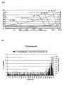
- the determination of the required density profiles K ( q ) takes place within the framework of a mathematical analysis.
- the density profiles are determined as a function of a certain inflow probability q , which essentially corresponds to the traffic demand.
- a selection of such profiles for different q shows Fig. 2 , where very well the significantly higher local traffic density in the area of the traffic signal system (right edge of the graph) and the traffic density increasing overall with increasing traffic demand / inflow probability q are recognizable.
- the required parameters of the Nagel-Schreckberg model which can vary depending on the network edge, are the respective length L of the relevant road section (typically segment start to stop line), the (maximum permissible) speed v max and the traffic light phase g for the (effective ) Green and r for the (effective) red phase. Yellow phases are neglected in the concrete embodiment of the method according to the invention, but can be taken into account as needed.
- the available floating cars now transmit their respective current position independent of the surrounding traffic situation and without grid reference in the reporting strategy, ie, for example, at regular time intervals or initially store it internally within the framework of a suitable system architecture and later send as a package, but then not only the Vehicles themselves, but also the reported FCD positions distributed according to the current density profile of the associated road section.
- FCD messages occur on the respective road segment in the area of the traffic light backlog (quantitatively the associated FCD positions Density profile correspondingly) is more likely to occur than on the part with free traffic.
- Another important advantage of the statistical method used in the method according to the invention is also a special form of self-correction is that regardless of the actual quantitative correctness of the reference density profiles K ( q ) that is always selected for describing the traffic situation, which in certain Best fits the observed FCD positions. In particular, this is the case if the model parameters (especially v max , g and r ) do not correspond exactly to the real conditions. Because of the basically qualitative similarity of Density profiles K ( q ) for different constellations of the model parameters can, however, to a certain extent be determined even if the model is incorrectly calibrated, an approximately correct traffic situation (self-correction), ie in particular the correct tailback length at traffic light installations.
- the calculation of the desired traffic situation parameters is in fact in complete consistency with the rest of the inventive method by a return of the estimated q * in the traffic model used, from the original, analytical determination of the multiple reference density profiles K ( q ) directly concrete formulas such as the expected, average tailback length L congestion, average ( q *), the expected, maximum stowage length L congestion, max ( q *) and their standard deviations ⁇ ( L congestion, average ( q *)) and ⁇ ( L congestion, max ( q *)) can be derived.
- the estimated value q * and the associated density profile K ( q *) can be output.
- a final peculiarity which additionally distinguishes the method according to the invention against other approaches to traffic position detection, is the fact that in addition to all these concrete values, even a complete probability distribution ⁇ ( q *) derived for the model analysis for the number of vehicles in the respective road section at the end of a red phase can be specified, which represents in a special way at the same time, among other things, a distribution for the average and maximum backwater length. Consequently, in addition to the aforementioned traffic parameters, all values (eg variance, higher moments, quantiles) which are contained as distribution properties in ⁇ ( q *) can be determined.
- the available FCD speed data could additionally be made available via the data fusion interface described above, in that the parameter space ⁇ of the maximum likelihood estimation in the context of the method according to the invention is based on small or large values of the traffic demand / Inflow probability q was limited, with a complete supersaturation of the considered road section was excluded in principle.
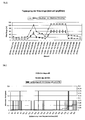
- the significantly better and again completely plausible, minimally smoothed results shows Fig. 9 , while emphasizing that the same database as in Fig. 8 underlying. Overall, it was thus possible to demonstrate in an advantageous manner that good results can still be achieved with the method according to the invention even with a comparatively thin or apparently insufficient database.
Abstract
Description
Die Erfindung betrifft ein Verfahren und eine Vorrichtung zur Ermittlung von Rückstaulängen an Lichtsignalanlagen.The invention relates to a method and a device for determining tailback lengths of traffic signal systems.
Das wesentliche Problem der Verkehrslageerfassung im Straßenverkehr besteht heutzutage im Allgemeinen darin, auf Basis einer vergleichsweise dünnen Datengrundlage sinnvolle bzw. korrekte Aussagen über den aktuellen Verkehrszustand im jeweils betrachteten Verkehrsnetz zu treffen. Als Grund für die dünne Datenbasis ist dabei in erster Linie zu nennen, dass der größte Teil der derzeit verwendeten Messeinrichtungen (Induktionsschleifen, ...) jeweils nur lokale Informationen liefert, sodass für die Straßenabschnitte zwischen zwei solchen Detektoren keine direkten Verkehrsdaten gemessen werden können. Neuere Arten von Detektoren wie Videokameras oder FCD-Systeme, die grundsätzlich zu einer flächigen Erfassung des Verkehrs in der Lage sind, haben jeweils andere Nachteile.The essential problem of traffic situation detection in traffic today is generally based on a comparatively thin data basis to make meaningful or correct statements about the current traffic condition in each considered transport network. The reason for the thin database is primarily to mention that the majority of currently used measuring equipment (induction loops, ...) provides only local information, so that no direct traffic data can be measured for the road sections between two such detectors. Newer types of detectors, such as video cameras or FCD systems, which are in principle capable of a comprehensive detection of traffic, each have other disadvantages.
Insgesamt müssen daher im Hinblick auf eine flächendeckende Verkehrslageerfassung durch geschickte Aufbereitung der jeweiligen Verkehrsdaten über die erfassten Messwerte hinaus Zusatzinformationen gewonnen werden, wozu im Allgemeinen mehr oder weniger komplexe Verkehrsmodelle (Warteschlangenmodelle, Zellularautomaten, ...) oder empirische Zusammenhänge zwischen den Daten verschiedener Detektoren (Stichwort: Datenfusion) verwendet werden können.Overall, additional information must therefore be obtained in addition to the acquired measured values with regard to nationwide traffic situation detection through skilful processing of the respective traffic data, including generally more or less complex traffic models (queue models, cellular automata,...) Or empirical relationships between the data of different detectors. Keyword: data fusion) can be used.
Im Rahmen der Verkehrslageerfassung gibt es verschiedene Möglichkeiten der Messung von Verkehrsdaten. Speziell im Hinblick auf die Ermittlung von Rückstaulängen an Lichtsignalanlagen sind aber - wie oben erwähnt - in aller Regel zusätzliche Überlegungen notwendig, da Staulängen im allgemeinen nur mit großem technischen bzw. finanziellen Aufwand direkt gemessen werden können.As part of the traffic situation detection, there are various ways of measuring traffic data. Especially with regard to the determination of tailback lengths of traffic lights but - as mentioned above - usually additional considerations necessary because jam lengths can generally be measured directly only with great technical or financial effort.
Die einfachste Methode der Verkehrslageerfassung ist die manuelle Verkehrszählung, bei der vor Ort durch entsprechende Personen Verkehrsbeobachtungen durchgeführt werden. Diese Form der Verkehrslageerfassung kann allerdings sinnvollerweise zeitlich nur in eng umgrenzten Maßen stattfinden und liefert mitunter auch nur sehr grobe Daten. Folglich können solche Daten kaum zur Gewinnung von flächendeckenden und zeitnahen Verkehrsinformationen genutzt werden. Vielmehr dienen sie als rein historische Informationen, die hauptsächlich zu Offline-Planungszwecken und als Erfahrungswerte verwendet werden.The simplest method of traffic monitoring is manual traffic counting, where on-site traffic observations are carried out by appropriate persons. This form of traffic situation detection can, however, usefully take place only within a limited time frame and sometimes provides only very rough data. Consequently, such data can hardly be used to obtain comprehensive and timely data Traffic information is used. Rather, they serve as purely historical information that is used primarily for offline planning purposes and as empirical values.
Eine einfache Weiterentwicklung ist die Beobachtung des Straßenverkehrs an ausgewählten Straßenabschnitten und Knotenpunkten mit Hilfe von Videokameras, deren Bilder zeitaktuell auf verschiedenen Monitoren einer Verkehrsleitzentrale angezeigt werden. Dadurch kann ein relativ großes Gebiet von einer einzelnen Person gleichzeitig beobachtet werden. Nichtsdestotrotz bleibt das Problem, dass ein solches System nicht vollständig automatisiert ablaufen kann, sodass ferner die Qualität wesentlich von der Aufmerksamkeit und der Erfahrung der jeweiligen Person abhängt, die in der Verkehrsleitzentrale die Kamerabilder auswerten muss.A simple further development is the observation of the road traffic at selected road sections and junctions with the help of video cameras, the images of which are displayed up-to-the-minute on different monitors of a traffic control center. As a result, a relatively large area can be observed by a single person at the same time. Nonetheless, the problem remains that such a system can not be completely automated so that, in addition, the quality depends substantially on the attention and experience of the individual who needs to evaluate the camera images in the traffic control center.
Entsprechend wurden bislang zahlreiche Methoden entwickelt, um vollständig automatisch Verkehrsinformationen, d.h. konkret Rückstaulängen an Lichtsignalanlagen, zu erfassen und zu verarbeiten. Im Rahmen der Verkehrslageerfassung mit klassischen Schleifendetektoren (Induktionsschleifen) werden in der Regel Verkehrsstärken, Belegungszeiten des jeweiligen Detektors und Zeitlücken zwischen den Fahrzeugen gemessen (Je nach Konstruktion sind ferner lokale Geschwindigkeiten der Fahrzeuge messbar.). Über die Belegungszeiten bei einem Schleifendetektor im Bereich vor einer Lichtsignalanlage kann dabei entschieden werden, ob ein entsprechender Ampelrückstau auf die Strecke zwischen Lichtsignalanlage und Detektor beschränkt ist oder mindestens bis an den Detektor hinanreicht. Eine genauere Angabe der Rückstaulänge ist mit dieser Methode jedoch nicht möglich.Accordingly, numerous methods have been developed heretofore for fully automatic traffic information, i. Specifically detention lengths at traffic lights, to capture and process. As part of the traffic situation detection with classic loop detectors (induction loops) usually traffic levels, occupancy times of the respective detector and time gaps between the vehicles are measured (depending on the design also local speeds of the vehicles are measurable.). About the occupancy times in a loop detector in the area in front of a traffic signal system can be decided whether a corresponding traffic light backlog is limited to the distance between the traffic signal and detector or at least reaches up to the detector. However, a more exact indication of the backpressure length is not possible with this method.
Ferner ist zu bemerken, dass die Gültigkeit der Messwerte von Schleifendetektoren insbesondere in urbanen Verkehrsnetzen in der Regel lokal stark begrenzt ist. Mit anderen Worten ist es nicht unwahrscheinlich, dass ein Detektor, der vielleicht nur 100 Meter von einem anderen entfernt installiert ist, völlig andere Daten misst. Folglich müssten für eine unmittelbare, flächendeckende Verkehrslageerfassung mit Induktionsschleifen (dasselbe gilt auch für Detektoren mit ähnlichen Charakteristika, z.B. Infrarot- oder Radarsensoren) entsprechende Detektoren in relativ nahen Abständen zueinander installiert werden, was etwa für das Verkehrsnetz einer ganzen Stadt schon aus wirtschaftlicher Sicht nicht realistisch ist.Furthermore, it should be noted that the validity of the measured values of loop detectors, in particular in urban traffic networks, is generally strongly limited locally. In other words, it is not unlikely that a detector that is perhaps only 100 meters away from another will measure completely different data. Consequently, for immediate, area-wide traffic situation detection with induction loops (the same is true for detectors with similar characteristics, such as infrared or radar sensors) corresponding detectors must be installed in relatively close distances to each other, which is not realistic for the traffic network of an entire city from an economic point of view is.
Wie oben bereits erwähnt, benutzen daher die klügeren Verfahren zur Verkehrslageerfassung entweder geeignete Verkehrsmodelle oder verknüpfen auf geschickte Weise die Messwerte mehrerer Detektoren, um daraus weitere Informationen zu gewinnen. So ist ein Verfahren mit einem einfachen Bilanzierungsansatz bekannt, bei dem die Rückstaulänge über den Vergleich der Anzahl zu- und abfließender Fahrzeuge geschätzt wird, wobei der Zufluss in jedem Fall mittels eines Detektors kontrolliert wird. In einer ersten Version des Verfahrens wird ein einfaches Verkehrsmodell verwendet, indem für die abfließenden Fahrzeuge ein gleichmäßiges Anfahren der gestauten Fahrzeuge mit konstantem, zeitlichem Abstand angenommen wird. In einer zweiten Variante wird auch der Abfluss mit Hilfe eines Schleifendetektors kontrolliert.As mentioned above, therefore, the smarter traffic detection methods either use appropriate traffic models or skillfully link the readings of multiple detectors to obtain more information. Thus, a method with a simple balancing approach is known, in which the backpressure length is estimated by comparing the number of inflowing and outflowing vehicles, the inflow being controlled in each case by means of a detector. In a first version of the method, a simple traffic model is used by assuming a uniform approach of the jammed vehicles with a constant, temporal distance for the departing vehicles. In a second variant, the outflow is also controlled by means of a loop detector.
In beiden Fällen können allerdings Staus, die über den Detektor vor der Lichtsignalanlage hinausreichen, bezüglich ihrer Länge nicht quantifiziert werden. Ferner stellt das Verfahren gewisse Anforderungen an die räumliche Lage der Induktionsschleifen, die in der Realität nicht überall gegeben ist. Findet die Bilanzierung schließlich in der bevorzugten Variante mit Hilfe des Vergleichs der Daten zweier Detektoren statt, führt dies zusätzlich dazu, dass das Verfahren sehr sensibel auf fehlerhafte Daten oder den Ausfall eines der Detektoren reagiert.In both cases, however, jams that extend beyond the detector in front of the traffic light can not be quantified in terms of their length. Furthermore, the method makes certain demands on the spatial position of the induction loops, which is not given everywhere in reality. Finally, if the balancing in the preferred variant takes place with the aid of the comparison of the data of two detectors, this additionally leads to the method reacting very sensitively to erroneous data or the failure of one of the detectors.
Weiter ist ein modellbasiertes Verfahren zur Verkehrslageerfassung an Lichtsignalanlagen bekannt, das als Eingangsgröße auf jeder Netzkante (lediglich) die Zähl- und Geschwindigkeitsdaten eines einzelnen Schleifendetektors benötigt, für den bezüglich seiner relativen Position zur Lichtsignalanlage allerdings zusätzliche Bedingungen gelten. Da die tatsächlichen Entfernungen zwischen Lichtsignalanlage und Detektor bei den zahlreichen, bereits vorhandenen Zählschleifen in vielen Fällen nicht den geforderten 100 bis 150 Metern entsprechen dürften, wäre für eine flächendeckende Anwendung des Verfahrens insgesamt die Installation vieler zusätzlicher Detektoren erforderlich, was schon aus Kostengründen nicht realistisch scheint.Furthermore, a model-based method for traffic position detection on traffic signal systems is known, which (only) requires the counting and speed data of a single loop detector as an input variable on each network edge, but with regard to its relative position to the traffic signal system additional conditions apply. Since the actual distances between the traffic signal system and the detector in many of the already existing counting loops should not in many cases correspond to the required 100 to 150 meters, the widespread application of the method would require the installation of many additional detectors, which does not seem realistic for reasons of cost ,
Um das Problem der lokalen Detektion (etwa bei Induktionsschleifen), bei der nur an einzelnen, auf wenige Meter begrenzten Straßenquerschnitten Daten gemessen werden können, zu umgehen, werden seit einiger Zeit - wie schon oben erwähnt - digitale Kameras zur Verkehrsbeobachtung eingesetzt, da mit ihrer Hilfe jeweils eine ganze Fläche des Verkehrsnetzes (nämlich das gesamte Sichtfeld der Kamera), z.B. eine Kreuzung, gleichzeitig erfasst werden kann. Mit dem Ziel der Automatisierung der Analyse der Kamerabilder wird dabei eine digitale Bildverarbeitung nachgeschaltet, die Fahrzeuge (oder allgemeiner bewegte Objekte) erkennt und daraus Verkehrsdaten wie etwa Rückstaulängen an Lichtsignalanlagen generiert.In order to circumvent the problem of local detection (for example in induction loops), in which data can only be measured at individual road cross sections bordered on a few meters, digital cameras for traffic monitoring have been used for some time now, as already mentioned above Help each an entire area of the transport network (namely, the entire field of view of the camera), such as an intersection, can be detected simultaneously. With the aim of automating the analysis The camera images are followed by a digital image processing that recognizes vehicles (or more generally moving objects) and generates traffic data such as tailback lengths at traffic light systems.
Schwierig ist in diesem Zusammenhang aber nach wie vor die korrekte Erkennung von Fahrzeugen aufgrund diverser Effekte wie Schattenwurf, Verdeckung oder Dunkelheit bei den aufgezeichneten Kamerabildern. Tatsächlich ist es wegen derselben Phänomene selbst für einen Menschen mitunter nicht einfach, Fahrzeuge auf den Bildern richtig zu unterscheiden. Ferner gilt, dass Staus ohne weiteres natürlich nur innerhalb des Sichtfelds der Kamera detektiert werden können, sodass es auch hier (etwa bei einer an einer Kreuzung installierten Kamera) eine konzeptionelle Obergrenze für die detektierbare Länge des Ampelrückstaus gibt.In this context, the correct detection of vehicles due to various effects such as shadows, occlusion or darkness in the recorded camera images is still difficult. In fact, because of the same phenomena, it is sometimes not easy even for a human being to properly distinguish vehicles in the images. Furthermore, it goes without saying that jams can of course only be detected within the field of view of the camera, so that there is also a conceptual upper limit for the detectable length of the traffic light jam here (for example in the case of a camera installed at an intersection).
Ein in dieser Hinsicht unproblematisches Hilfsmittel bietet die ebenfalls noch vergleichsweise junge FCD-Technologie, bei der (je nach Konstruktion des Systems auch völlig anonym) die Positionen (ggf. auch weitere aktuelle Fahrzeugdaten wie Geschwindigkeit, Blinkeraktivität, Scheibenwischereinstellung, ...) einzelner so genannter Floating Cars zu gewissen Zeitpunkten an eine Zentrale gesendet werden, wo sie zusammen mit den Daten anderer Floating Cars ausgewertet werden können. Da ferner Floating Cars grundsätzlich überall im Straßennetz unterwegs sein können, sind FCD-Systeme stärker noch als die Verkehrsbeobachtung mit Videokameras und anders als die klassischen Verkehrsdetektoren bereits vom Konzept her zu einer flächendeckenden Verkehrslageerfassung in der Lage.An equally unproblematic aid in this respect is the comparatively young FCD technology, in which (depending on the design of the system, also completely anonymous) the positions (possibly also other current vehicle data such as speed, turn signal activity, windscreen wiper setting, ...) are like that Floating Cars are sent at certain times to a central office, where they can be evaluated together with the data of other floating cars. Furthermore, since floating cars can be everywhere on the road in general, FCD systems are even stronger than the traffic observation with video cameras and unlike the classic traffic detectors already conceptually to a comprehensive traffic situation detection in a position.
Hierin zeigt sich allerdings gleichzeitig auch die wesentliche Schwäche aller bisherigen FCD-Anwendungen: Grundsätzlich sind im Rahmen der aktuell betriebenen FCD-Systeme die verwendeten FCD-Flottengrößen in Relation zur Größe des betrachteten Verkehrsnetzes sehr klein, sodass alle reinen FCD-Verfahren derzeit mit einer extrem dünnen Datengrundlage auskommen müssen. Folglich haben Floating Car Daten in vielen Anwendungen rein unterstützenden Charakter und dienen lediglich zur Kontrolle von auf anderem Weg gewonnenen Verkehrsdaten.At the same time, however, this also shows the essential weakness of all previous FCD applications: In principle, the FCD fleet sizes used in the current FCD systems are very small in relation to the size of the considered transport network, so that all pure FCD methods are currently used with an extremely high FCD thin data basis. As a result, floating-car data is purely supportive in many applications and merely serves to control traffic data obtained by other means.
Um im Fall fehlender oder zu weniger aktueller Floating Car Daten dennoch eine Verkehrslage bestimmen zu können, ist es selbstverständlich möglich, sämtliche Messwerte kontinuierlich in einer Datenbank abzulegen, sodass zu jedem zukünftigen Zeitpunkt bei fehlenden oder zu wenigen Daten historische Informationen in geeigneter Weise zur jeweils aktuellen Datenbasis hinzugefügt werden können. Dabei geht zwar je nach Anteil an ergänzten historischen Messwerten ein Teil der Aktualität des jeweils auf Basis der erweiterten Datengrundlage ermittelten Verkehrszustandes verloren. Da der Straßenverkehr im Allgemeinen aber vielfach periodisch wiederkehrende Muster zeigt (z.B. typische Hauptverkehrszeiten, ...), kann durch geschickte Auswahl der zusätzlichen historischen Daten (z.B. unter Berücksichtigung von Wochentag und Uhrzeit) eine allzu grobe Verfälschung der Ergebnisse im Wesentlichen vermieden werden.In order to be able to determine a traffic situation in the event of missing or too less current floating car data, it is of course possible to store all measured values continuously in a database, so that for each future Date of missing or too little data historical information can be added in a suitable manner to the current database. Depending on the proportion of supplemented historical measured values, part of the timeliness of the traffic condition determined in each case on the basis of the extended data basis is lost. However, as road traffic in general often reveals periodically recurring patterns (eg typical rush hours, ...), a skilful selection of additional historical data (eg taking into account the day of the week and the time of day) can substantially avoid grossly falsifying the results.
Im Hinblick auf die konkreten Verfahren zur Verkehrslageerfassung mittels FCD (insbesondere in urbanen Verkehrsnetzen) werden in den meisten aktuellen Anwendungen Floating Cars verwendet, die neben Zeitstempel und aktueller Position (ggf. auch aktueller Geschwindigkeit, ...) bei jeder FCD-Meldung an die Zentrale jeweils eine eindeutige Fahrzeug-Identifikationsnummer mitschicken. Auf diese Weise kann über geeignete Map-Matching- und Routing-Algorithmen für jedes Fahrzeug die gefahrene Route (Trajektorie) im Straßennetz weitestgehend rekonstruiert werden. Ferner ergibt sich jeweils für die Strecke zwischen je zwei aufeinanderfolgenden FCD-Meldungen aus der Differenz der zugehörigen Zeitstempel eine Reisezeit, die als wesentliche Verkehrsinformation betrachtet werden kann. Mit Hilfe des leicht zu ermittelnden Wissens über die Länge jeder dieser Strecken (Teil-Trajektorien), die durchaus mehrere Netzkanten umfassen kann, ist es überdies möglich, unmittelbar eine durchschnittliche Reisegeschwindigkeit für den jeweils befahrenen Straßenzug zu berechnen.With regard to the concrete methods for traffic monitoring using FCD (especially in urban transport networks) are used in most current applications floating cars, in addition to timestamp and current position (possibly also current speed, ...) for each FCD message to the Send each central office a unique vehicle identification number. In this way, the route traveled (trajectory) in the road network can be reconstructed as far as possible by means of suitable map matching and routing algorithms for each vehicle. Furthermore, in each case for the distance between each two consecutive FCD messages from the difference of the associated time stamp results in a travel time, which can be regarded as essential traffic information. In addition, with the help of easily ascertained knowledge about the length of each of these sections (partial trajectories), which may well comprise several network edges, it is possible to directly calculate an average cruising speed for the respective road section being traveled.
Unglücklicherweise sind die so gewonnenen Verkehrsdaten allerdings bedingt durch die komplexe Dynamik des Verkehrsflusses insbesondere in urbanen Verkehrsnetzen stark verrauscht, was die weitergehende Auswertung vielfach erschwert. Dies liegt daran, dass die Reisezeiten stark von der jeweiligen Lichtsignalanlage-Phase variieren, die das jeweilige FCD-Fahrzeug vorfindet (z.B. grüne Welle oder im Gegensatz hierzu viele Rot-Phasen).Unfortunately, due to the complex dynamics of the traffic flow, the traffic data obtained in this way is very noisy, especially in urban traffic networks, which often complicates the further evaluation. This is because the travel times vary greatly from the particular traffic signal phase that the particular FCD vehicle encounters (e.g., green wave or, conversely, many red phases).
Ferner sind die Reisezeiten, die in der beschriebenen Situation im Allgemeinen nicht zwingend bezogen auf die einzelnen Netzkanten der unterliegenden digitalen Karte vorliegen, nur schwer im Rahmen des Verkehrsmanagements, d.h. speziell im Hinblick auf die Steuerung von Lichtsignalanlagen, interpretierbar.Furthermore, travel times, which in the situation described are generally not necessarily related to the individual network edges of the underlying digital map, are difficult to interpret in the context of traffic management, ie especially with regard to the control of traffic lights.
Aus der
Aus der
Dabei stellt die benötigte Form der Meldezeitpunkte (Meldung jeweils an den Netzknoten) erhöhte Anforderungen an die Ausstattung der verwendeten Floating Cars gegenüber der derzeit häufig benutzten Methode, dass Floating Cars schlicht in regelmäßigen Zeitabständen (typischerweise 30 Sekunden bis 5 Minuten) ihre jeweils aktuellen Positionsdaten übermitteln.In this case, the required form of the reporting times (message at the network node) increased demands on the equipment of floating cars used compared to the currently commonly used method that floating cars simply at regular intervals (typically 30 seconds to 5 minutes) transmit their current position data ,
Grundsätzlich wäre es für die Auswertung von Floating Car Daten natürlich bereits sehr nützlich, wenn die erfassten Fahrzeugdaten mit möglichst kurzen Zeitabständen zwischen den einzelnen FCD-Meldungen verfügbar wären. Der wesentliche Engpass aller FCD-Systeme ist allerdings die Kommunikation zwischen den Fahrzeugen und der Zentrale. Da die Verbindung derzeit in der Regel über kostenpflichtige Mobilfunknetze (GSM, UMTS) hergestellt wird, ist eine kontinuierliche Datenübertragung schon aus wirtschaftlicher Sicht nicht möglich.Basically, it would be very useful for the evaluation of floating car data, of course, if the recorded vehicle data with the shortest possible time intervals between the individual FCD messages would be available. The main bottleneck of all FCD systems, however, is the communication between the vehicles and the control center. Since the connection is currently usually made via paid mobile networks (GSM, UMTS), a continuous data transfer is not possible even from an economic point of view.
Aus der
Aus der
Aus der
Durch eine Analyse der Verteilung der Mobiltelefone und im Falle, dass eine Identifizierung der einzelnen Mobiltelefone, d.h. eine Verfolgung über die Zeit möglich ist, durch die Auswertung der Bewegungsmuster jedes einzelnen Mobiltelefons kann dabei entschieden werden, ob ein erfasstes Mobiltelefon etwa in einem PKW mitbewegt wird, einem Radfahrer gehört oder einem Fußgänger zuzuordnen ist. Geht man beispielsweise davon aus, dass langfristig vermutlich nahezu jeder Autofahrer ein Mobiltelefon mit sich führen wird, kann folglich praktisch jedes Fahrzeug im Straßenverkehr bezüglich seiner Position erfasst werden. Anschließend können etwa alle so ermittelten PKW-Positionen mittels eines Map-Matchings graphisch als Punkte in einer digitalen Karte dargestellt werden. Aufgrund einer höheren Verkehrsdichte lassen sich dann etwa Staus leicht an den Häufungen solcher Punkte erkennen. Die Auswertung der Graphiken erfolgt dabei entweder manuell oder mittels einer automatischen Bildverarbeitung durch den Vergleich mit zuvor gespeicherten Verkehrsmustern, für die die gewünschten Verkehrslagekenngrößen wie Rückstaulängen bereits ermittelt wurden. Allerdings lebt das Verfahren wesentlich davon, dass ein möglichst großer Teil der Verkehrsteilnehmer erfasst werden kann, sodass unabhängig von dem immensen Datenvolumen, das bei einer weiträumigen Anwendung des Verfahrens anfallen würde, eine möglicherweise wünschenswerte Übertragung der beschriebenen graphischen Methode auf ein klassisches FCD-System, bei dem die Ortungsgenauigkeit typischerweise deutlich höher ist, derzeit nicht möglich scheint.By analyzing the distribution of the mobile phones and in the event that an identification of the individual mobile phones, ie a tracking over time is possible by the evaluation of the movement pattern of each mobile phone can be decided whether a detected mobile phone is moved about in a car belongs to a cyclist or to a pedestrian. Assuming, for example, that in the long term, presumably almost every car driver will carry a mobile phone with him, virtually every vehicle in the road can be compared to his Position are recorded. Subsequently, for example, all the car positions determined in this way can be represented graphically as points in a digital map by means of map matching. Due to a higher traffic density, congestion can easily be identified by the accumulation of such points. The graphics are evaluated either manually or by means of automatic image processing by comparison with previously stored traffic patterns for which the desired traffic situation parameters such as tailback periods have already been determined. However, the method essentially depends on the fact that the largest possible proportion of road users can be detected, so that, regardless of the immense volume of data that would be generated by a widespread use of the method, a possibly desirable transfer of the described graphical method to a classic FCD system, where the tracking accuracy is typically significantly higher, currently seems not possible.
Aus dem Fachartikel "
Der Erfindung liegt das technische Problem zugrunde, ein Verfahren und eine Vorrichtung zur Ermittlung von Rückstaulängen an Lichtsignalanlagen zu schaffen, die mit geringem messtechnischen Aufwand Rückstaulängen über einen weiten Bereich ermitteln können.The invention is based on the technical problem of providing a method and a device for determining tailback lengths of traffic signal systems, which can determine backstop lengths over a wide range with little metrological outlay.
Die Lösung des technischen Problems ergibt sich durch die Gegenstände mit den Merkmalen der Patentansprüche 1 und 9. Weitere vorteilhafte Ausgestaltungen der Erfindung ergeben sich aus den Unteransprüchen.The solution of the technical problem results from the objects with the features of
Das Verfahren und die Vorrichtung zur Ermittlung von Rückstaulängen an Lichtsignalanlagen mittels einer Datenverarbeitungseinrichtung sind dadurch gekennzeichnet, dass in der Datenverarbeitungseinrichtung ein Verkehrsmodell für Straßensegmente mit Lichtsignalanlagen implementiert ist, wobei das Verkehrsmodell mindestens Dichteprofile in Abhängigkeit eines Parameters liefert, wobei über eine Schnittstelle der Datenverarbeitungseinrichtung Positionsdaten von Meldefahrzeugen im jeweiligen Straßensegment zugeführt werden und ein Schätzungsverfahren zur Ermittlung des Dichteprofils durchführbar ist, das mit den ermittelten Positionsdaten die größte Übereinstimmung aufweist, wobei eine Rückstaulänge an den Lichtsignalanlagen mittels des Verkehrsmodells unter Berücksichtigung des Parameters des ausgewählten Dichteprofils ermittelt wird. Die Positionsdaten können dabei hochgenaue GPS-Daten sein, aber auch beispielsweise Positionsdaten, die mittels eines Mobilfunktelefons ermittelt wurden. Dabei ist eine Identifizierung der Meldefahrzeuge und/oder Mobilfunktelefone nicht zwingend. Weiter benötigt das Verfahren nur wenige Positionsdaten, um bereits brauchbare Ergebnisse zu liefern. Die Positionsdaten werden vorzugsweise mit einem Zeitstempel versehen, bevor diese an die Vorrichtung übermittelt werden. Dabei sei angemerkt, dass unter Verkehrsmodell allgemein auch eine geeignete, parameterabhängige, mathematische Funktion verstanden wird.The method and the device for determining tailback lengths at traffic light installations by means of a data processing device are characterized in that a traffic model for road segments with traffic signal systems is implemented in the data processing device, the traffic model providing at least density profiles as a function of a parameter, wherein position data of Reporting vehicles are supplied in each road segment and an estimation method for the determination the density profile can be carried out, which has the greatest agreement with the determined position data, wherein a reset length is determined at the traffic signals by means of the traffic model taking into account the parameter of the selected density profile. The position data can be highly accurate GPS data, but also, for example, position data that has been determined by means of a mobile telephone. In this case, an identification of the reporting vehicles and / or mobile phones is not mandatory. Furthermore, the method requires only a few position data to deliver useful results. The position data are preferably provided with a time stamp before they are transmitted to the device. It should be noted that the term "traffic model" generally also means a suitable, parameter-dependent, mathematical function.
Mögliche Anwendungen der so ermittelten Rückstaulängendaten sind z.B. die Qualitätssicherung im Verkehrsmanagement etwa im Rahmen einer Kontrolle der Auswirkungen von Änderungen bei den Schaltplänen der Lichtsignalsteuerung oder die verkehrslageabhängige Navigation in urbanen Straßennetzen. Bei einer ausreichenden Versorgung mit Floating-Car-Daten ist ferner auch ein Online-Verkehrsmanagement im Sinne einer zeitaktuellen, verkehrslageabhängigen Verkehrsbeeinflussung (Lichtsignalsteuerung, dynamisches Routing, ...) denkbar.Possible applications of the backlog length data thus determined are e.g. Quality assurance in traffic management, for example, in the context of controlling the effects of changes in the traffic light circuit diagrams or traffic-dependent navigation in urban road networks. In the case of an adequate supply of floating-car data, an online traffic management in the sense of an up-to-the-minute, traffic-dependent traffic influencing (traffic signal control, dynamic routing, etc.) is also conceivable.
Überdies ist das erfindungsgemäße Verfahren natürlich auch für alle anderen Formen von Verkehrs- oder Transportnetzen mit ähnlichen Rahmenbedingungen (Kanten mit periodisch geregeltem Abfluss) geeignet, um Stauungen der jeweiligen Verkehrsobjekte am Kantenende bezüglich ihrer Länge zu erfassen.Moreover, the method according to the invention is naturally also suitable for all other forms of traffic or transport networks with similar framework conditions (edges with periodically controlled outflow) in order to detect congestion of the respective traffic objects at the edge end with respect to their length.
Überdies beinhaltet das Verfahren implizit einen gewissen Mechanismus zur Selbstkorrektur, sodass sogar die im Vergleich zu anderen Ansätzen der modellgestützten Verkehrslageerfassung wenigen benötigten Parameter vielfach nur grob geschätzt werden müssen. Wie bei der Datenbasis stellt das erfindungsgemäße Verfahren also vergleichsweise geringe Anforderungen an die erforderlichen Modellparameter, was zum einen den Kalibrierungsaufwand minimiert und zum anderen das Verfahren in gewisser Weise zusätzlich robuster macht.Moreover, the method implicitly incorporates some mechanism for self-correction, so that even the few required parameters compared to other approaches of the model-based traffic situation detection often need only be roughly estimated. As in the case of the database, the method according to the invention therefore places comparatively small demands on the required model parameters, which on the one hand minimizes the calibration effort and on the other hand additionally makes the method more robust in a certain way.
In einer bevorzugten Ausführungsform werden dem Verkehrsmodell die Parameter Segmentlänge (Straßenlänge) und Steuerparameter der Lichtsignalanlage zugeführt, also beispielsweise die Dauer der Rot- und Grünphasen.In a preferred embodiment, the parameters segment length (road length) and control parameters of the traffic signal system are supplied to the traffic model, so for example the duration of the red and green phases.
Weiter vorzugsweise werden dem Verkehrsmodell zusätzlich eine maximale Geschwindigkeit der Kraftfahrzeuge und/oder ein Korrekturterm als Parameter zugeführt. Bei der maximalen Geschwindigkeit kann es sich um die gesetzliche Höchstgeschwindigkeit handeln oder aber um die empirisch ermittelte tatsächlich gefahrene Höchstgeschwindigkeit handeln, wobei letzterer der Vorzug zu geben ist.Further preferably, the traffic model is additionally supplied with a maximum speed of the motor vehicles and / or a correction term as a parameter. The maximum speed may be the legal maximum speed or the empirically determined actually driven maximum speed, the latter being preferred.
In einer weiteren bevorzugten Ausführungsform sind die Dichteprofile vom Parameter Zufluss bzw. Zufluss-Wahrscheinlichkeit/Verkehrsnachfrage abhängig.In a further preferred embodiment, the density profiles depend on the parameter inflow or inflow probability / traffic demand.
In einer weiteren bevorzugten Ausführungsform ist das Verkehrsmodell als Nagel-Schreckenberg-Modell ausgebildet. Der Vorteil dieses Modells ist, dass dieses nicht zu kompliziert ist und dennoch hinreichend genaue Dichteprofile liefert. Des Weiteren liefert das Modell nicht nur mittlere oder maximale Werte für die jeweils gewünschten Verkehrsparameter, sondern sogar vollständige, approximative Wahrscheinlichkeitsverteilungen für die entsprechenden Kenngrößen, insbesondere die Rückstaulängen an LSAs.In a further preferred embodiment, the traffic model is designed as a Nagel-Schreckberg model. The advantage of this model is that it is not too complicated and yet provides sufficiently accurate density profiles. Furthermore, the model not only provides mean or maximum values for the respective desired traffic parameters, but even complete, approximate probability distributions for the corresponding parameters, in particular the tailback lengths at LSAs.
In einer weiteren bevorzugten Ausführungsform ist das Schätzverfahren eine Maximum-Likelihood-Schätzung. Die Methode der Maximum-Likelihood-Schätzung hat den Vorteil, dass die Zuordnung der entsprechenden Referenz weniger von einem subjektiven Eindruck des Betrachters abhängt und mit Hilfe eines standardmäßigen, numerischen Optimierungsalgorithmus durchgeführt werden kann, der mitunter zusätzlich ein Qualitätsmaß für die Verlässlichkeit bzw. Eindeutigkeit der Zuordnung angeben kann. Ein weiterer Vorteil ist, dass sehr einfach weitere Daten (Stichwort Datenfusion) neben den Positionsdaten bei der Ermittlung des geeignetsten Dichteprofils berücksichtigt werden können, wodurch insbesondere bei nur geringer Datenbasis von Positionsdaten trotzdem eine sehr gute Schätzung erreicht werden kann (Einschränkung des Parameterraums durch die zusätzlichen Daten). Anstelle der Einschränkung des Parameterraumes können auch einzelne Parameter anhand von a priori Informationen gewichtet werden.In a further preferred embodiment, the estimation method is a maximum likelihood estimation. The method of the maximum likelihood estimation has the advantage that the assignment of the corresponding reference is less dependent on a subjective impression of the observer and can be carried out with the aid of a standard numerical optimization algorithm, which sometimes additionally provides a quality measure for the reliability or unambiguity of the Can specify assignment. Another advantage is that very simple additional data (keyword data fusion) in addition to the position data in the determination of the most appropriate density profile can be considered, which in particular with only a small database of position data still a very good estimate can be achieved (restriction of the parameter space by the additional Dates). Instead of limiting the parameter space, individual parameters can also be weighted on the basis of a priori information.
In einer weiteren bevorzugten Ausführungsform gehen neben den Positionsdaten weitere Daten der Meldefahrzeuge (z.B. Geschwindigkeit) und/oder von externen Sensoren (z.B. Induktionsschleifen) und/oder a priori Informationen (z.B. historische Verläufe der Dichteprofile in Abhängigkeit von Wochentag und Uhrzeit) in die Schätzung zur Ermittlung des Dichteprofils ein.In a further preferred embodiment, in addition to the position data, further data of the reporting vehicles (eg speed) and / or of external sensors (eg induction loops) and / or a priori information (eg historical profiles of the density profiles as a function of day of the week and time) are included in the estimate Determination of the density profile.
In einer weiteren bevorzugten Ausführungsform werden durch das Verkehrsmodell weitere Verkehrsparameter des Straßensegments ermittelt und/oder Parameter für eine adaptive Steuerung der Lichtsignalanlage generiert.In a further preferred embodiment, the traffic model determines further traffic parameters of the road segment and / or generates parameters for adaptive control of the traffic signal system.
Das zuvor für die Ermittlung von Rückstaulängen an Lichtsignalanlagen beschriebene Verfahren ist allgemein verwendbar zur Ermittlung von Rückstaulängen an zeitweise blockierten Ausgängen von Kanten eines Transportnetzes. Dabei wird entsprechend ein Modell benutzt, um Dichteprofile in Abhängigkeit eines Parameters zu erhalten, wobei das Modell auch aus einfachen mathematischen Funktionen bestehen kann. Die sich auf dem Transportnetz bewegenden Objekte geben dann Positionsdaten ab, wobei dann wieder mittels eines Schätzverfahrens das zu den Positionsdaten am besten passende Dichteprofil ermittelt wird und der oder die zugehörigen Parameter in das Modell zurückgeführt werden und daraus eine Rückstaulänge berechnet wird. Eine mögliche Anwendung in der Logistik ist das Nachverfolgen von Paketen, Containern oder ähnlichen Objekten, die teilweise mit Mitteln zur Übermittlung von Positionsdaten ausgebildet sind. Das Transportnetz kann dabei beispielsweise als Fließband bzw. Transportband ausgebildet sein. Wird dann beispielsweise das Transportband an einer Stelle gestoppt, weil beispielsweise derzeit kein LKW oder ähnliches Transportmittel vorhanden ist, um die Objekte weiterzutransportieren, so kommt es zu einem Rückstau. Anhand der Berechnung des Rückstaus können dann Gegenmaßnahmen eingeleitet werden oder aber Transportzeiten besser vorhergesagt werden.The method described above for the determination of tailback lengths at traffic light systems is generally usable for determining tailback periods at temporarily blocked outputs of edges of a transport network. In this case, a model is used to obtain density profiles as a function of a parameter, whereby the model can also consist of simple mathematical functions. The objects moving on the transport network then output position data, in which case the density profile which best matches the position data is again determined by means of an estimation method, and the associated parameter or parameters are fed back into the model and from this a backlog length is calculated. A possible application in logistics is the tracking of packages, containers or similar objects, which are partly designed with means for transmitting position data. The transport network can be designed, for example, as a conveyor belt or conveyor belt. If, for example, the conveyor belt is then stopped at one point, because, for example, there is currently no truck or similar means of transport in order to transport the objects further, a backlog occurs. On the basis of the calculation of the backwater, countermeasures can be initiated or transport times can be better predicted.
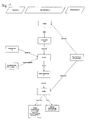
Die Erfindung wird nachfolgend anhand eines bevorzugten Ausführungsbeispiels näher erläutert. Die Fig. zeigen:
- Fig. 1
- ein schematisches Ablaufdiagramm eines Verfahrens zur Ermittlung einer Rückstaulänge an einer Lichtsignalanlage,
- Fig. 2
- Verkehrsdichteprofile für verschiedene Zufluss-Wahrscheinlichkeiten,
- Fig. 3
- eine Zuordnung eines Dichteprofils zu gemessenen Positionsdaten,
- Fig. 4
- ein Verlauf der Durchschnittsgeschwindigkeit über der Tageszeit,
- Fig. 5
- einen Wochengang der maximalen Staulänge,
- Fig. 6
- einen geglätteten Tagesgang der Staulänge,
- Fig. 7
- ein FCD-Dichteprofil,
- Fig. 8
- einen Tagesgang der Staulänge und
- Fig. 9
- einen geglätteten Tagesgang der Staulänge.
- Fig. 1
- a schematic flow diagram of a method for determining a Rückstaulänge at a traffic signal system,
- Fig. 2
- Traffic density profiles for different inflow probabilities,
- Fig. 3
- an assignment of a density profile to measured position data,
- Fig. 4
- a course of the average speed over the time of day,
- Fig. 5
- a weekly cycle of maximum stowage length,
- Fig. 6
- a smoothed daily routine of the stowage length,
- Fig. 7
- a FCD density profile,
- Fig. 8
- a daily routine of the stowage length and
- Fig. 9
- a smoothed daily routine of the stub length.
Die originäre Eingangsgröße des erfindungsgemäßen Verfahrens bilden die Positionsdaten xi einer Stichprobe von relevanten Verkehrsobjekten (Floating Cars bzw. Melderfahrzeuge), die als Ergebnis eines Map-Matchings netzkantenbezogen als Entfernungen zu einem beliebigen, aber festen Referenzpunkt des jeweiligen Straßenabschnitts vorliegen. Als Referenzpunkt können in vorteilhafter Weise etwa der Segmentanfang oder die Haltelinie der Lichtsignalanlage am Segmentende gewählt werden. Je nach Datenlage (Anzahl an aktuell erfassten FCD-Positionen) kann ferner die Datenbasis in beliebigem Umfang mit historischen Daten aus einer Datenbank ergänzt werden. Insbesondere können in einer vorteilhaften Ausführung des erfindungsgemäßen Verfahrens unter der Annahme periodisch wiederkehrender Verkehrsmuster bei einer zu geringen FCD-Abdeckung gespeicherte Positionsdaten desselben Wochentags und/oder derselben Tageszeit nach Netzkanten differenziert zu den Eingangsgrößen des Verfahrens hinzugefügt werden. Wie bereits zuvor erwähnt ist es dabei völlig unerheblich, auf welchem Weg die benötigten Positionsdaten erfasst werden/wurden. Beispielsweise ist mit geeigneter Vorabprozessierung, d.h. Unterscheidung nach Typen (Fußgänger, Radfahrer, Fahrzeuge, ...) auch die Positionsbestimmung der relevanten Verkehrsobjekte mittels Mobilfunktelefonen möglich.The original input variable of the method according to the invention form the position data x i of a sample of relevant traffic objects (floating cars or detector vehicles), which are present as a result of map matching network edge related as distances to any, but fixed reference point of the respective road section. As a reference point, for example, the segment start or the stop line of the traffic light system can be selected at the end of the segment. Depending on the data situation (number of currently recorded FCD positions), the database can also be supplemented to any extent with historical data from a database. In particular, in an advantageous embodiment of the method according to the invention, assuming periodically recurring traffic patterns, position data of the same day of the week and / or the same time of day stored after network edges can be differentiated to the input variables of the method if the FCD coverage is too low. As already mentioned above, it is completely irrelevant in which way the required position data are / were recorded. For example, with suitable pre-processing, ie differentiation according to types (pedestrians, cyclists, vehicles, etc.), the position determination of the relevant traffic objects by means of mobile telephones is possible.
Grundlegend für das erfindungsgemäße Verfahren ist nun die Tatsache, dass es innerhalb eines (urbanen) Straßennetzes typischerweise genau an den Lichtsignalanlagen zu Häufungen von Fahrzeugen und zu Wartezeiten kommt. Geht man nun von einer (annähernd) homogenen Verteilung der verfügbaren Floating Cars auf die Menge aller am Verkehr beteiligten Fahrzeuge aus, so kann man annehmen, dass die Floating Cars räumlich im Wesentlichen gemäß den jeweils aktuellen Profilen lokaler Verkehrsdichten im Verkehrsnetz verstreut sind. Mit anderen Worten halten sich in Abschnitten mit einer hohen lokalen Verkehrsdichte (z.B. vor Lichtsignalanlagen) also relativ mehr Floating Cars auf als etwa in Bereichen mit freiem Verkehrsfluss und entsprechend niedrigerer lokaler Verkehrsdichte.Fundamental to the method according to the invention is now the fact that within an (urban) road network, it is typical for traffic light installations to accumulate vehicles and wait. You go Now from a (nearly) homogeneous distribution of the available floating cars on the amount of all vehicles involved in traffic, it can be assumed that the floating cars are spatially scattered essentially according to the current profiles of local traffic densities in the transport network. In other words, in sections with a high local traffic density (eg, traffic light systems), there are relatively more floating cars than, for example, areas with free traffic flow and correspondingly lower local traffic density.
Auf Basis eines Verkehrsmodells, das eines der wesentlichen Bestandteile der Verfahrensebene der erfindungsgemäßen Methode darstellt, können dann entsprechende Profile lokaler Verkehrsdichten analytisch oder durch Simulation abgeleitet werden. In einer vorteilhaften Ausführung, die das Verfahren einer effizienteren numerischen Umsetzbarkeit zuführt, findet die Bestimmung der benötigten Dichteprofile K(q) im Rahmen einer mathematischen Analyse statt. Dabei werden die Dichteprofile in Abhängigkeit von einer gewissen Zufluss-Wahrscheinlichkeit q bestimmt, die in wesentlichen Zügen der Verkehrsnachfrage entspricht. Eine Auswahl solcher Profile für verschiedene q zeigt
Die erforderlichen Parameter des Nagel-Schreckenberg-Modells, die je nach Netzkante variieren (können), sind schließlich die jeweilige Länge L des relevanten Straßenabschnitts (typischerweise Segmentanfang bis Haltelinie), die (zulässige) Höchstgeschwindigkeit v max sowie die Ampelphasendauern g für die (effektive) Grün- und r für die (effektive) Rotphase. Gelbphasen werden in der konkreten Ausführung des erfindungsgemäßen Verfahrens vernachlässigt, können aber bedarfsweise berücksichtigt werden.The required parameters of the Nagel-Schreckberg model, which can vary depending on the network edge, are the respective length L of the relevant road section (typically segment start to stop line), the (maximum permissible) speed v max and the traffic light phase g for the (effective ) Green and r for the (effective) red phase. Yellow phases are neglected in the concrete embodiment of the method according to the invention, but can be taken into account as needed.
Unter der für viele aktuell laufende FCD-Systeme zutreffenden Bedingung, dass nun die verfügbaren Floating Cars unabhängig von der umgebenden Verkehrssituation und ohne Netzbezug in der Meldestrategie, d.h. beispielsweise in regelmäßigen Zeitabständen ihre jeweils aktuelle Position übermitteln bzw. im Rahmen einer geeigneten Systemarchitektur zunächst intern speichern und später als Paket senden, sind dann aber nicht nur die Fahrzeuge selbst, sondern auch die gemeldeten FCD-Positionen gemäß dem jeweils aktuellen Dichteprofil des zugehörigen Straßenabschnitts verteilt. Falls es also mit anderen Worten im verwendeten Datenerfassungsprozess keine speziellen ereignis- oder netzbezogenen Meldezeitpunkte (bzw. Zeitpunkte für die vorübergehende fahrzeuginterne Speicherung) der aktuellen FCD-Positionen gibt, treten FCD-Meldungen auf dem jeweils betrachteten Straßensegment im Bereich des Ampelrückstaus (quantitativ dem zugehörigen Dichteprofil entsprechend) mit größerer Wahrscheinlichkeit auf als etwa auf dem Teil mit freiem Verkehr.Under the condition applicable to many current FCD systems, the available floating cars now transmit their respective current position independent of the surrounding traffic situation and without grid reference in the reporting strategy, ie, for example, at regular time intervals or initially store it internally within the framework of a suitable system architecture and later send as a package, but then not only the Vehicles themselves, but also the reported FCD positions distributed according to the current density profile of the associated road section. In other words, if in the data acquisition process used there are no special event or network-related reporting times (or times for temporary in-vehicle storage) of the current FCD positions, FCD messages occur on the respective road segment in the area of the traffic light backlog (quantitatively the associated FCD positions Density profile correspondingly) is more likely to occur than on the part with free traffic.
Unterstellt man nun für den (grundsätzlich beliebig wählbaren) Zeitraum, währenddessen die jeweils als Datengrundlage verwendeten FCD-Positionen registriert wurden, eine stationäre Verkehrssituation, d.h. nimmt man an, dass alle FCD-Positionen gemäß demselben Dichteprofil K(q*) mit einem eindeutig zugeordneten, aber unbekannten q* ∈ [0,1] verteilt sind, so ist im Hinblick auf eine statistische Schätzung von q* zu fragen, für welches Dichteprofil bzw für welche Verkehrslage die Kombination aller Positionsdaten die maximale Wahrscheinlichkeit hat.Assuming now for the (in principle arbitrary) period during which the FCD positions used as the data basis were registered, a stationary traffic situation, ie assuming that all FCD positions according to the same density profile K ( q *) with a unique assigned , but unknown q * ∈ [0,1] are distributed, one has to ask for a statistical estimate of q * for which density profile or traffic situation the combination of all position data has the maximum probability.
Dies ist der wesentliche Bestandteil des Verfahrensbausteins "Fusion" in
Im Rahmen der Maximum-Likelihood-Schätzung kann es dabei aus technischen Gründen von Vorteil sein, den zunächst überabzählbaren Parameterraum Θ zunächst einzuschränken und so die Menge an möglichen Verkehrszuständen, genauer an Referenz-Dichteprofilen K(q) im Vorfeld zu verkleinern oder allgemeiner im Vorfeld der Schätzung des Parameters q* eine a priori Gewichtung der zulässigen Parameter vorzunehmen. Denkbar ist beispielsweise, anstelle des gesamten, reellen Intervalls [0,1] nur die ganzzahligen Vielfachen einer gewissen Schrittweite h zu betrachten, sodass der eingeschränkte (nun endliche) Parameterraum durch Θ̃ := {q ∈ Θ | q = k · h, k ∈ IN0} beschrieben werden kann.In the context of the maximum likelihood estimation, it may be advantageous for technical reasons to first limit the initially uncountable parameter space Θ and thus to reduce the amount of possible traffic conditions, more precisely reference density profiles K ( q ) in advance, or more generally in advance the estimation of the parameter q * an a priori weighting of the permissible parameters make. It is conceivable, for example, to consider only the integer multiples of a certain step size h instead of the entire, real interval [0,1], so that the restricted (now finite) parameter space is given by Θ: = { q ∈ Θ | q = k · h, k ∈ IN 0 }.
Gleichzeitig bietet diese Möglichkeit, den für die Maximum-Likelihood-Schätzung grundlegenden Parameterraum im Vorfeld praktisch beliebig manipulieren zu können, in nahezu natürlicher Weise eine Schnittstelle, um zusätzliche Verkehrsinformationen in das Verfahren zu integrieren. Sind beispielsweise aktuelle Geschwindigkeitsdaten vi der relevanten Floating Cars verfügbar und sind diese im Durchschnitt vergleichsweise niedrig, so deutet dies unter Umständen auf eine eher hohe Verkehrsnachfrage hin (vgl.
Ist aufgrund anderer Verkehrsdaten überdies bereits eine eindeutige Verkehrslage mit dem korrespondierenden q* bekannt, so kann der Parameterraum Θ in höchst flexibler Weise formal sogar auf einen einzigen Wert, nämlich q* reduziert werden. Mit anderen Worten wäre also im Rahmen des erfindungsgemäßen Verfahrens das Ergebnis der beschriebenen Maximum-Likelihood-Schätzung bereits vor ihrem Einsatz eindeutig festgelegt.If, due to other traffic data, an unambiguous traffic situation with the corresponding q * is already known, the parameter space Θ can even be formally reduced to a single value, namely q *, in a highly flexible manner. In other words, in the context of the method according to the invention, the result of the maximum likelihood estimation described would already be clearly defined even before it is used.
Ein weiterer, wichtiger Vorteil der im erfindungsgemäßen Verfahren verwendeten, statistischen Methode besteht ferner als spezielle Form der Selbstkorrektur darin, dass unabhängig von der tatsächlichen, quantitativen Richtigkeit der Referenz-Dichteprofile K(q) stets dasjenige zur Beschreibung der Verkehrslage ausgewählt wird, das in bestimmter Weise am besten zu den beobachteten FCD-Positionen passt. Insbesondere ist dies der Fall, wenn die Modellparameter (speziell v max, g und r) nicht genau den realen Gegebenheiten entsprechen. Wegen der grundsätzlich qualitativen Ähnlichkeit der Dichteprofile K(q) für verschiedene Konstellationen der Modellparameter kann dadurch aber in gewissem Maße selbst bei fehlerhafter Kalibrierung des Modells eine annähernd korrekte Verkehrslage (Selbstkorrektur), d.h. insbesondere die richtige Rückstaulänge an Lichtsignalanlagen ermittelt werden. Lediglich die entsprechende Schätzung für q*, die in gewisser Weise eine Art Korrekturterm darstellt, dürfte in diesem Fall im Allgemeinen nicht mehr mit der tatsächlichen Verkehrsnachfrage übereinstimmen, wenngleich q* als Eingangsgröße der abschließenden Ergebnisgenerierung im unteren Verfahrensblock "Modell" (siehe
Die Berechung der gewünschten Verkehrslagekenngrößen erfolgt nämlich in völliger Konsistenz mit dem Rest des erfindungsgemäßen Verfahrens durch eine Rückführung des geschätzten q* in das verwendete Verkehrsmodell, wobei aus der ursprünglichen, analytischen Ermittlung der mehrfach genannten Referenz-Dichteprofile K(q) unmittelbar konkrete Formeln etwa für die erwartete, mittlere Rückstaulänge L Stau, Durchschnitt(q*), die erwartete, maximale Staulänge L Stau,max(q*) sowie deren Standardabweichungen σ(L Stau,Durchschnitt(q*)) und σ(L Stau,max(q*)) abgeleitet werden können. Überdies können natürlich der Schätzwert q* und das zugehörige Dichteprofil K(q*) ausgegeben werden.The calculation of the desired traffic situation parameters is in fact in complete consistency with the rest of the inventive method by a return of the estimated q * in the traffic model used, from the original, analytical determination of the multiple reference density profiles K ( q ) directly concrete formulas such as the expected, average tailback length L congestion, average ( q *), the expected, maximum stowage length L congestion, max ( q *) and their standard deviations σ ( L congestion, average ( q *)) and σ ( L congestion, max ( q *)) can be derived. Moreover, of course, the estimated value q * and the associated density profile K ( q *) can be output.
Eine abschließende Besonderheit, die das erfindungsgemäße Verfahren - wie weiter oben bereits erwähnt - gegenüber anderen Ansätzen zur Verkehrslageerfassung zusätzlich auszeichnet, ist schließlich die Tatsache, dass neben all diesen konkreten Werten sogar eine vollständige, im Rahmen der Modellanalyse hergeleitete Wahrscheinlichkeitsverteilung π(q*) für die Anzahl an Fahrzeugen im jeweiligen Straßenabschnitt am Ende einer Rotphase angegeben werden kann, die in besonderer Weise zugleich unter anderem eine Verteilung für die mittlere und maximale Rückstaulänge darstellt. Folglich können neben den genannten Verkehrskenngrößen sämtliche Werte (z.B. Varianz, höhere Momente, Quantile) bestimmt werden, die als Verteilungseigenschaften in π(q*) enthalten sind.Finally, a final peculiarity, which additionally distinguishes the method according to the invention against other approaches to traffic position detection, is the fact that in addition to all these concrete values, even a complete probability distribution π ( q *) derived for the model analysis for the number of vehicles in the respective road section at the end of a red phase can be specified, which represents in a special way at the same time, among other things, a distribution for the average and maximum backwater length. Consequently, in addition to the aforementioned traffic parameters, all values (eg variance, higher moments, quantiles) which are contained as distribution properties in π ( q *) can be determined.
Um schließlich die Funktionsweise des erfindungsgemäßen Verfahrens zu überprüfen und die Vorteilhaftigkeit zu belegen, wurde im Weiteren eine Auswertung auf Basis realer Verkehrsdaten (Positions- und Geschwindigkeitsdaten) vorgenommen. Durch Zusammenfassung aller FCD-Positionen eines Monats ergab sich dabei nach Wochentagen differenziert bei einer Datendichte wie in
Im Hinblick auf die Detektion tageszeitlicher Schwankungen bei der Rückstaulänge wurde zusätzlich ein weiterer Datensatz mit realen Positions- und Geschwindigkeitsdaten von Floating Cars über fünf Wochen für einen anderen Straßenabschnitt ausgewertet. Dabei wurden die Daten stundenweise nach Uhrzeit gruppiert und anschließend über alle Werktage (Montag bis Freitag) hinweg zusammengefasst. Im Ergebnis ergaben sich folglich 24 Einzeldatensätze (einer für jede Stunde des Tages), die stundenweise jeweils die Positionsdaten aller Werktage des Erfassungszeitraums enthielten und anschließend einzeln ausgewertet wurden. Die resultierende Tagesganglinie eines typischen Werktags für die Rückstaulänge an der betrachteten Lichtsignalanlage ist in einer minimal geglätteten Form in
Bemerkenswert dabei ist, dass durch die Differenzierung der FCD-Positionsdaten nach den Stunden des Tages die einzelnen stundenweisen Datensätze im Vergleich etwa zum vorherigen Beispiel (Datendichte: über 400 Datenpunkte) eine extrem dünne Datengrundlage bilden (vgl.
Tatsächlich gestaltet sich die Situation in anderen Fällen mitunter schwieriger (s.
Über die weiter oben beschriebene Datenfusions-Schnittstelle konnten im konkreten Beispiel allerdings zusätzlich die verfügbaren FCD-Geschwindigkeitsdaten nutzbar gemacht werden, indem je nach Durchschnittsgeschwindigkeit der Parameterraum Θ der Maximum-Likelihood-Schätzung im Rahmen des erfindungsgemäßen Verfahrens auf kleine bzw. große Werte der Verkehrsnachfrage/Zufluss-Wahrscheinlichkeit q eingeschränkt wurde, wobei eine vollständige Übersättigung des betrachteten Straßenabschnitts grundsätzlich ausgeschlossen wurde. Die deutlich besseren und wiederum völlig plausiblen, minimal geglätteten Ergebnisse zeigt
Abschließend sollen natürlich allgemeine Erweiterungsmöglichkeiten genannt werden, die mitunter noch weitere Anwendungsfelder umfassen:
- Bisher wurde im verwendeten Verkehrsmodell keine spezielle Unterscheidung nach Richtungsspuren vorgenommen. Insbesondere können dadurch zunächst keine Rückstaulängen etwa für die unterschiedlichen Fahrtrichtungen (rechts, links, geradeaus) an Kreuzungen unterschieden werden. Ist aus den verwendeten Floating Car Daten allerdings entweder aufgrund einer hochgenauen Ortung oder z.B. durch Kenntnis der Fahrtrouten eine Zuordnung der einzelnen Fahrzeuge zu jeweils einer Richtungsspur möglich, so kann in einfacher Weise durch Gruppierung des Datensatzes nach diesem Kriterium leicht eine richtungsspurbezogene Auswertung mit Hilfe des erfindungsgemäßen Verfahrens realisiert werden.
- Wie bereits mehrfach erwähnt ist für das erfindungsgemäße Verfahren grundsätzlich eine Kopplung mit einer Systemarchitektur wie beispielsweise in
DE 10 2004 039 854 A1DE 101 10 326 A1 DE 101 10 327 A1 - Wegen seiner hohen Flexibilität ist das erfindungsgemäße Verfahren sowohl mit klassischen FCD-Systemen (direkte Kommunikation zwischen Floating Cars und Zentrale) als auch mit nahezu jeder Form der neueren (teilweise dezentralen) Ansätze (Car-2-Infrastructure und Car-2-car) kompatibel. Folglich ist eine vielseitige und langfristige Einsetzbarkeit des erfindungsgemäßen Verfahrens grundsätzlich vorstellbar.
- In seiner beschriebenen Ausführung für den Straßenverkehr ist das erfindungsgemäße Verfahren ein eindimensionaler Ansatz in dem Sinne, dass die Verkehrsdichte entlang einer (eindimensionalen) Strecke (Straßenabschnitt) betrachtet wird. Formal ist mit den verwendeten mathematischen Methoden aber auch jede höher-dimensionale Variante durchführbar. Insbesondere könnte etwa auch der Verkehr auf einer zweidimensionalen Fläche mit den gleichen Methoden erfasst werden, wobei in diesem Fall die Referenz-Dichteprofile anschaulich zu Dichtegebirgen werden.
- Entsprechend ist die Anwendung des erfindungsgemäßen Verfahrens konzeptionell nicht auf Straßenverkehrsnetze beschränkt, sondern kann grundsätzlich auf beliebige Verkehrs- und Transportnetze wie z.B. den Fußgängerverkehr (zweidimensional) oder den Luftverkehr (dreidimensional) übertragen werden.
- Wie bei jedem Verfahren zur Verkehrslageerfassung können überdies die Ergebnisse kontinuierlich in einer Datenbank gespeichert und zu verschiedenen Zwecken weiterverwendet werden. Zu nennen sind hier beispielsweise strategische Verkehrsmanagement-Anwendungen (Planung, Qualitätssicherung, ...) oder Ansätze zur Verkehrsprognose auf Basis historischer und/oder aktueller Verkehrsdaten.
- So far, no particular distinction was made in the traffic model used for directional tracks. In particular, this means that initially no tailback lengths can be distinguished, for example, for the different directions of travel (right, left, straight ahead) at intersections. Is from the floating car data, however, either due to a highly accurate location or eg by knowing the routes an assignment of each vehicle to each direction track possible, it can easily by grouping the record according to this criterion easily a direction-track-related evaluation using the invention Procedure be realized.
- As already mentioned several times is for the inventive method in principle a coupling with a system architecture such as in
DE 10 2004 039 854 A1DE 101 10 326 A1 DE 101 10 327 A1 - Because of its high flexibility, the method according to the invention is compatible both with classical FCD systems (direct communication between floating cars and central office) and with virtually every form of the more recent (partially decentralized) approaches (Car-2 Infrastructure and Car-2-car) , Consequently, a versatile and long-term applicability of the method according to the invention is basically conceivable.
- In its described embodiment for road traffic, the method according to the invention is a one-dimensional approach in the sense that the traffic density along a (one-dimensional) route (road section) is considered. Formally, with the mathematical methods used, however, any higher-dimensional variant can be carried out. In particular, for example, the traffic on a two-dimensional surface could also be detected by the same methods, in which case the reference density profiles become clear to density mountains.
- Accordingly, the application of the method according to the invention is conceptually not limited to road transport networks, but can in principle be transferred to any traffic and transport networks such as pedestrian traffic (two-dimensional) or air traffic (three-dimensional).
- In addition, as with any traffic assessment procedure, the results can be continuously stored in a database and used for various purposes. These include, for example, strategic traffic management applications (planning, quality assurance, ...) or approaches to traffic prognosis based on historical and / or current traffic data.
Claims (16)
Applications Claiming Priority (1)
| Application Number | Priority Date | Filing Date | Title |
|---|---|---|---|
| DE102008022349A DE102008022349A1 (en) | 2008-05-02 | 2008-05-02 | Method and device for determining tailback lengths at traffic lights |
Publications (3)
| Publication Number | Publication Date |
|---|---|
| EP2116981A2 true EP2116981A2 (en) | 2009-11-11 |
| EP2116981A3 EP2116981A3 (en) | 2009-12-09 |
| EP2116981B1 EP2116981B1 (en) | 2012-10-03 |
Family
ID=40999988
Family Applications (1)
| Application Number | Title | Priority Date | Filing Date |
|---|---|---|---|
| EP20090090002 Active EP2116981B1 (en) | 2008-05-02 | 2009-02-20 | Method and device for calculating backlog lengths at traffic lights |
Country Status (2)
| Country | Link |
|---|---|
| EP (1) | EP2116981B1 (en) |
| DE (1) | DE102008022349A1 (en) |
Cited By (4)
| Publication number | Priority date | Publication date | Assignee | Title |
|---|---|---|---|---|
| DE102012204123A1 (en) | 2012-03-15 | 2013-09-19 | Deutsches Zentrum für Luft- und Raumfahrt e.V. | Method for determining queue length of traffic objects and/or vehicle groups, involves determining numerically identified traffic density by interpolation and core approximations at specific order, with extreme and/or turning points |
| CN110766955A (en) * | 2019-09-18 | 2020-02-07 | 平安科技(深圳)有限公司 | Signal adjusting method and device based on motion prediction model and computer equipment |
| CN114863678A (en) * | 2022-04-26 | 2022-08-05 | 交通运输部公路科学研究所 | Optimized layout method and system for road safety risk detectors in intelligent networking environment |
| CN115394086A (en) * | 2022-10-26 | 2022-11-25 | 北京闪马智建科技有限公司 | Traffic parameter prediction method, device, storage medium and electronic device |
Families Citing this family (4)
| Publication number | Priority date | Publication date | Assignee | Title |
|---|---|---|---|---|
| DE102012204306A1 (en) | 2012-03-19 | 2013-09-19 | Bayerische Motoren Werke Aktiengesellschaft | A method of controlling provision of traffic information data for updating traffic information |
| CN106710245B (en) * | 2016-12-23 | 2019-06-28 | 西华大学 | Through street multilane ramp metering rate method based on density |
| DE102018202909A1 (en) | 2018-02-27 | 2019-08-29 | Deutsches Zentrum für Luft- und Raumfahrt e.V. | Method and device for controlling a traffic signal system |
| DE102018010003A1 (en) | 2018-12-27 | 2020-07-02 | Volkswagen Aktiengesellschaft | Backflow detection from movement data |
Citations (5)
| Publication number | Priority date | Publication date | Assignee | Title |
|---|---|---|---|---|
| DE10022812A1 (en) | 2000-05-10 | 2001-11-22 | Daimler Chrysler Ag | Method for determining the traffic situation on the basis of reporting vehicle data for a traffic network with traffic-regulated network nodes |
| DE10018562C1 (en) | 2000-04-14 | 2002-02-07 | Daimler Chrysler Ag | Traffic data provision method for traffic network uses data signaling vehicles which circulate with traffic flow for providing data for each regulated network node |
| DE10110326A1 (en) | 2001-03-03 | 2002-09-19 | Daimler Chrysler Ag | Determination system for finding actual traffic situation using positions of mobile phones with varying density of mobile phones over time related to traffic situation and vehicle behavior |
| DE10110327A1 (en) | 2001-03-03 | 2002-09-19 | Daimler Chrysler Ag | Position determination system for actual traffic situation uses mobile phones with unique identifying number allowing phone density and locations to be monitored over time |
| DE102004039854A1 (en) | 2004-08-17 | 2006-03-09 | Siemens Ag | Method for determining traffic information, methods for controlling the traffic, and system for carrying out the method |
Family Cites Families (4)
| Publication number | Priority date | Publication date | Assignee | Title |
|---|---|---|---|---|
| IL131700A0 (en) * | 1999-03-08 | 2001-03-19 | Mintz Yosef | Method and system for mapping traffic congestion |
| DE50100263D1 (en) * | 2001-07-11 | 2003-06-26 | Transver Gmbh | Procedure for determining a congestion index and for determining backflow lengths |
| EP1480184A3 (en) * | 2003-05-19 | 2006-06-07 | TransVer GmbH | Method for detecting road traffic characteristics at access points |
| DE102005024953A1 (en) * | 2005-05-31 | 2006-12-07 | Siemens Ag | Method for determining turning rates in a road network |
-
2008
- 2008-05-02 DE DE102008022349A patent/DE102008022349A1/en not_active Withdrawn
-
2009
- 2009-02-20 EP EP20090090002 patent/EP2116981B1/en active Active
Patent Citations (5)
| Publication number | Priority date | Publication date | Assignee | Title |
|---|---|---|---|---|
| DE10018562C1 (en) | 2000-04-14 | 2002-02-07 | Daimler Chrysler Ag | Traffic data provision method for traffic network uses data signaling vehicles which circulate with traffic flow for providing data for each regulated network node |
| DE10022812A1 (en) | 2000-05-10 | 2001-11-22 | Daimler Chrysler Ag | Method for determining the traffic situation on the basis of reporting vehicle data for a traffic network with traffic-regulated network nodes |
| DE10110326A1 (en) | 2001-03-03 | 2002-09-19 | Daimler Chrysler Ag | Determination system for finding actual traffic situation using positions of mobile phones with varying density of mobile phones over time related to traffic situation and vehicle behavior |
| DE10110327A1 (en) | 2001-03-03 | 2002-09-19 | Daimler Chrysler Ag | Position determination system for actual traffic situation uses mobile phones with unique identifying number allowing phone density and locations to be monitored over time |
| DE102004039854A1 (en) | 2004-08-17 | 2006-03-09 | Siemens Ag | Method for determining traffic information, methods for controlling the traffic, and system for carrying out the method |
Non-Patent Citations (1)
| Title |
|---|
| NAGEL, K.; SCHRECKENBERG, M.: "A cellular automaton model for freeway traffic", I. PHYS. FRANCE, vol. 2, 1992, pages 2221 - 2229 |
Cited By (6)
| Publication number | Priority date | Publication date | Assignee | Title |
|---|---|---|---|---|
| DE102012204123A1 (en) | 2012-03-15 | 2013-09-19 | Deutsches Zentrum für Luft- und Raumfahrt e.V. | Method for determining queue length of traffic objects and/or vehicle groups, involves determining numerically identified traffic density by interpolation and core approximations at specific order, with extreme and/or turning points |
| DE102012204123B4 (en) * | 2012-03-15 | 2018-11-08 | Deutsches Zentrum für Luft- und Raumfahrt e.V. | Method and device for determining tailback lengths of traffic objects and / or vehicle spools |
| CN110766955A (en) * | 2019-09-18 | 2020-02-07 | 平安科技(深圳)有限公司 | Signal adjusting method and device based on motion prediction model and computer equipment |
| CN114863678A (en) * | 2022-04-26 | 2022-08-05 | 交通运输部公路科学研究所 | Optimized layout method and system for road safety risk detectors in intelligent networking environment |
| CN114863678B (en) * | 2022-04-26 | 2023-04-07 | 交通运输部公路科学研究所 | Optimized layout method and system for road safety risk detectors in intelligent networking environment |
| CN115394086A (en) * | 2022-10-26 | 2022-11-25 | 北京闪马智建科技有限公司 | Traffic parameter prediction method, device, storage medium and electronic device |
Also Published As
| Publication number | Publication date |
|---|---|
| EP2116981B1 (en) | 2012-10-03 |
| DE102008022349A1 (en) | 2009-11-12 |
| EP2116981A3 (en) | 2009-12-09 |
Similar Documents
| Publication | Publication Date | Title |
|---|---|---|
| EP2116981B1 (en) | Method and device for calculating backlog lengths at traffic lights | |
| EP3042368B1 (en) | Method, evaluation system and vehicle for forecasting at least a traffic jam parameter | |
| WO2013113588A1 (en) | Method for providing parking information on free parking spaces | |
| DE19904909C2 (en) | Method and device for providing traffic information | |
| EP1154389A1 (en) | Method to determine the traffic situation in a road network | |
| EP2953111B1 (en) | Method and device for determining free parking spots in hgv parking lots and notification of hgv drivers | |
| DE102014220687A1 (en) | Communication device for a vehicle and method for communicating | |
| DE10133945A1 (en) | Method and device for exchanging and processing data | |
| EP2936470B1 (en) | Method and system for learning traffic events, and use of the system | |
| DE102011083677A1 (en) | Method for predicting traffic conditions for e.g. electric car, involves determining future information for traffic conditions of vehicle based on current state of vehicle and historical data | |
| EP3014598A1 (en) | Method for processing measurement data of a vehicle in order to determine the start of a search for a parking space | |
| WO2014202362A1 (en) | Method for providing parking information on free parking spaces | |
| EP2280383A1 (en) | Method for determining traffic information for a section of a road network and traffic calculator to implement the method | |
| DE102008003039A1 (en) | Vehicle traffic condition recognizing method for traffic assistance system, involves differentiating traffic jam conditions on basis of measured speed, and recognizing traffic jam condition if another traffic jam condition is not recognized | |
| DE10057796B4 (en) | Method for vehicle-specific traffic condition forecasting | |
| DE10062856B4 (en) | Method for vehicle-specific traffic forecast | |
| DE102005009604B4 (en) | Method and device for generating a rating value for traffic data | |
| DE102004002808A1 (en) | Road traffic control system for controlling traffic lights incorporates data collected from observation vehicles, that is floating car data, to improve the control of traffic lights | |
| EP1489552B1 (en) | Method and apparatus for improving the identification and/or re-identification of objects in image processing | |
| DE10108611A1 (en) | Simulation and prediction method for individual motor vehicle movement within a road network, by separation of macroscopic modeling from microscopic or individual vehicle modeling | |
| DE10051777A1 (en) | Method for producing a dynamic forecast of traffic conditions for a road system around individual vehicles allows each vehicle to make an autonomic, continuous time-cum-location record for a parameter of traffic conditions | |
| DE10018562C1 (en) | Traffic data provision method for traffic network uses data signaling vehicles which circulate with traffic flow for providing data for each regulated network node | |
| EP3005334B1 (en) | System for determining traffic information | |
| EP2887332B1 (en) | Method and system for detection of a traffic situation on a stretch of road | |
| DE19944891A1 (en) | Method of detecting traffic situations with fuzzy classification, multidimensional morphological data filtering and dynamic domain formation |
Legal Events
| Date | Code | Title | Description |
|---|---|---|---|
| PUAI | Public reference made under article 153(3) epc to a published international application that has entered the european phase |
Free format text: ORIGINAL CODE: 0009012 |
|
| PUAL | Search report despatched |
Free format text: ORIGINAL CODE: 0009013 |
|
| AK | Designated contracting states |
Kind code of ref document: A2 Designated state(s): AT BE BG CH CY CZ DE DK EE ES FI FR GB GR HR HU IE IS IT LI LT LU LV MC MK MT NL NO PL PT RO SE SI SK TR |
|
| AX | Request for extension of the european patent |
Extension state: AL BA RS |
|
| AK | Designated contracting states |
Kind code of ref document: A3 Designated state(s): AT BE BG CH CY CZ DE DK EE ES FI FR GB GR HR HU IE IS IT LI LT LU LV MC MK MT NL NO PL PT RO SE SI SK TR |
|
| AX | Request for extension of the european patent |
Extension state: AL BA RS |
|
| 17P | Request for examination filed |
Effective date: 20100608 |
|
| AKX | Designation fees paid |
Designated state(s): AT BE BG CH CY CZ DE DK EE ES FI FR GB GR HR HU IE IS IT LI LT LU LV MC MK MT NL NO PL PT RO SE SI SK TR |
|
| RAP1 | Party data changed (applicant data changed or rights of an application transferred) |
Owner name: DEUTSCHES ZENTRUM FUER LUFT- UND RAUMFAHRT E.V. |
|
| RIC1 | Information provided on ipc code assigned before grant |
Ipc: G08G 1/01 20060101AFI20120308BHEP Ipc: G08G 1/08 20060101ALI20120308BHEP |
|
| GRAP | Despatch of communication of intention to grant a patent |
Free format text: ORIGINAL CODE: EPIDOSNIGR1 |
|
| RTI1 | Title (correction) |
Free format text: METHOD AND DEVICE FOR CALCULATING BACKLOG LENGTHS AT TRAFFIC LIGHTS |
|
| RIN1 | Information on inventor provided before grant (corrected) |
Inventor name: EBENDT, RUEDIGER, DR. Inventor name: WAGNER, PETER, DR. Inventor name: NEUMANN, THORSTEN |
|
| GRAS | Grant fee paid |
Free format text: ORIGINAL CODE: EPIDOSNIGR3 |
|
| GRAA | (expected) grant |
Free format text: ORIGINAL CODE: 0009210 |
|
| AK | Designated contracting states |
Kind code of ref document: B1 Designated state(s): AT BE BG CH CY CZ DE DK EE ES FI FR GB GR HR HU IE IS IT LI LT LU LV MC MK MT NL NO PL PT RO SE SI SK TR |
|
| REG | Reference to a national code |
Ref country code: GB Ref legal event code: FG4D Free format text: NOT ENGLISH |
|
| REG | Reference to a national code |
Ref country code: AT Ref legal event code: REF Ref document number: 578288 Country of ref document: AT Kind code of ref document: T Effective date: 20121015 Ref country code: CH Ref legal event code: EP |
|
| REG | Reference to a national code |
Ref country code: IE Ref legal event code: FG4D Free format text: LANGUAGE OF EP DOCUMENT: GERMAN |
|
| REG | Reference to a national code |
Ref country code: DE Ref legal event code: R096 Ref document number: 502009004938 Country of ref document: DE Effective date: 20121129 |
|
| PG25 | Lapsed in a contracting state [announced via postgrant information from national office to epo] |
Ref country code: SI Free format text: LAPSE BECAUSE OF FAILURE TO SUBMIT A TRANSLATION OF THE DESCRIPTION OR TO PAY THE FEE WITHIN THE PRESCRIBED TIME-LIMIT Effective date: 20121003 |
|
| REG | Reference to a national code |
Ref country code: NL Ref legal event code: VDEP Effective date: 20121003 |
|
| REG | Reference to a national code |
Ref country code: LT Ref legal event code: MG4D |
|
| PG25 | Lapsed in a contracting state [announced via postgrant information from national office to epo] |
Ref country code: HR Free format text: LAPSE BECAUSE OF FAILURE TO SUBMIT A TRANSLATION OF THE DESCRIPTION OR TO PAY THE FEE WITHIN THE PRESCRIBED TIME-LIMIT Effective date: 20121003 Ref country code: NO Free format text: LAPSE BECAUSE OF FAILURE TO SUBMIT A TRANSLATION OF THE DESCRIPTION OR TO PAY THE FEE WITHIN THE PRESCRIBED TIME-LIMIT Effective date: 20130103 Ref country code: IS Free format text: LAPSE BECAUSE OF FAILURE TO SUBMIT A TRANSLATION OF THE DESCRIPTION OR TO PAY THE FEE WITHIN THE PRESCRIBED TIME-LIMIT Effective date: 20130203 Ref country code: LT Free format text: LAPSE BECAUSE OF FAILURE TO SUBMIT A TRANSLATION OF THE DESCRIPTION OR TO PAY THE FEE WITHIN THE PRESCRIBED TIME-LIMIT Effective date: 20121003 Ref country code: ES Free format text: LAPSE BECAUSE OF FAILURE TO SUBMIT A TRANSLATION OF THE DESCRIPTION OR TO PAY THE FEE WITHIN THE PRESCRIBED TIME-LIMIT Effective date: 20130114 Ref country code: NL Free format text: LAPSE BECAUSE OF FAILURE TO SUBMIT A TRANSLATION OF THE DESCRIPTION OR TO PAY THE FEE WITHIN THE PRESCRIBED TIME-LIMIT Effective date: 20121003 Ref country code: FI Free format text: LAPSE BECAUSE OF FAILURE TO SUBMIT A TRANSLATION OF THE DESCRIPTION OR TO PAY THE FEE WITHIN THE PRESCRIBED TIME-LIMIT Effective date: 20121003 Ref country code: SE Free format text: LAPSE BECAUSE OF FAILURE TO SUBMIT A TRANSLATION OF THE DESCRIPTION OR TO PAY THE FEE WITHIN THE PRESCRIBED TIME-LIMIT Effective date: 20121003 |
|
| PG25 | Lapsed in a contracting state [announced via postgrant information from national office to epo] |
Ref country code: LV Free format text: LAPSE BECAUSE OF FAILURE TO SUBMIT A TRANSLATION OF THE DESCRIPTION OR TO PAY THE FEE WITHIN THE PRESCRIBED TIME-LIMIT Effective date: 20121003 Ref country code: GR Free format text: LAPSE BECAUSE OF FAILURE TO SUBMIT A TRANSLATION OF THE DESCRIPTION OR TO PAY THE FEE WITHIN THE PRESCRIBED TIME-LIMIT Effective date: 20130104 Ref country code: CY Free format text: LAPSE BECAUSE OF FAILURE TO SUBMIT A TRANSLATION OF THE DESCRIPTION OR TO PAY THE FEE WITHIN THE PRESCRIBED TIME-LIMIT Effective date: 20121003 Ref country code: PT Free format text: LAPSE BECAUSE OF FAILURE TO SUBMIT A TRANSLATION OF THE DESCRIPTION OR TO PAY THE FEE WITHIN THE PRESCRIBED TIME-LIMIT Effective date: 20130204 Ref country code: PL Free format text: LAPSE BECAUSE OF FAILURE TO SUBMIT A TRANSLATION OF THE DESCRIPTION OR TO PAY THE FEE WITHIN THE PRESCRIBED TIME-LIMIT Effective date: 20121003 |
|
| PG25 | Lapsed in a contracting state [announced via postgrant information from national office to epo] |
Ref country code: DK Free format text: LAPSE BECAUSE OF FAILURE TO SUBMIT A TRANSLATION OF THE DESCRIPTION OR TO PAY THE FEE WITHIN THE PRESCRIBED TIME-LIMIT Effective date: 20121003 Ref country code: CZ Free format text: LAPSE BECAUSE OF FAILURE TO SUBMIT A TRANSLATION OF THE DESCRIPTION OR TO PAY THE FEE WITHIN THE PRESCRIBED TIME-LIMIT Effective date: 20121003 Ref country code: EE Free format text: LAPSE BECAUSE OF FAILURE TO SUBMIT A TRANSLATION OF THE DESCRIPTION OR TO PAY THE FEE WITHIN THE PRESCRIBED TIME-LIMIT Effective date: 20121003 Ref country code: SK Free format text: LAPSE BECAUSE OF FAILURE TO SUBMIT A TRANSLATION OF THE DESCRIPTION OR TO PAY THE FEE WITHIN THE PRESCRIBED TIME-LIMIT Effective date: 20121003 Ref country code: BG Free format text: LAPSE BECAUSE OF FAILURE TO SUBMIT A TRANSLATION OF THE DESCRIPTION OR TO PAY THE FEE WITHIN THE PRESCRIBED TIME-LIMIT Effective date: 20130103 |
|
| PLBE | No opposition filed within time limit |
Free format text: ORIGINAL CODE: 0009261 |
|
| STAA | Information on the status of an ep patent application or granted ep patent |
Free format text: STATUS: NO OPPOSITION FILED WITHIN TIME LIMIT |
|
| PG25 | Lapsed in a contracting state [announced via postgrant information from national office to epo] |
Ref country code: IT Free format text: LAPSE BECAUSE OF FAILURE TO SUBMIT A TRANSLATION OF THE DESCRIPTION OR TO PAY THE FEE WITHIN THE PRESCRIBED TIME-LIMIT Effective date: 20121003 Ref country code: RO Free format text: LAPSE BECAUSE OF FAILURE TO SUBMIT A TRANSLATION OF THE DESCRIPTION OR TO PAY THE FEE WITHIN THE PRESCRIBED TIME-LIMIT Effective date: 20121003 |
|
| BERE | Be: lapsed |
Owner name: DEUTSCHES ZENTRUM FUR LUFT- UND RAUMFAHRT E.V. Effective date: 20130228 |
|
| 26N | No opposition filed |
Effective date: 20130704 |
|
| PG25 | Lapsed in a contracting state [announced via postgrant information from national office to epo] |
Ref country code: MC Free format text: LAPSE BECAUSE OF NON-PAYMENT OF DUE FEES Effective date: 20130228 |
|
| REG | Reference to a national code |
Ref country code: CH Ref legal event code: PL |
|
| GBPC | Gb: european patent ceased through non-payment of renewal fee |
Effective date: 20130220 |
|
| PG25 | Lapsed in a contracting state [announced via postgrant information from national office to epo] |
Ref country code: LI Free format text: LAPSE BECAUSE OF NON-PAYMENT OF DUE FEES Effective date: 20130228 Ref country code: CH Free format text: LAPSE BECAUSE OF NON-PAYMENT OF DUE FEES Effective date: 20130228 |
|
| REG | Reference to a national code |
Ref country code: DE Ref legal event code: R097 Ref document number: 502009004938 Country of ref document: DE Effective date: 20130704 |
|
| REG | Reference to a national code |
Ref country code: FR Ref legal event code: ST Effective date: 20131031 |
|
| REG | Reference to a national code |
Ref country code: IE Ref legal event code: MM4A |
|
| PG25 | Lapsed in a contracting state [announced via postgrant information from national office to epo] |
Ref country code: BE Free format text: LAPSE BECAUSE OF NON-PAYMENT OF DUE FEES Effective date: 20130228 Ref country code: FR Free format text: LAPSE BECAUSE OF NON-PAYMENT OF DUE FEES Effective date: 20130228 Ref country code: IE Free format text: LAPSE BECAUSE OF NON-PAYMENT OF DUE FEES Effective date: 20130220 Ref country code: GB Free format text: LAPSE BECAUSE OF NON-PAYMENT OF DUE FEES Effective date: 20130220 |
|
| PG25 | Lapsed in a contracting state [announced via postgrant information from national office to epo] |
Ref country code: MT Free format text: LAPSE BECAUSE OF FAILURE TO SUBMIT A TRANSLATION OF THE DESCRIPTION OR TO PAY THE FEE WITHIN THE PRESCRIBED TIME-LIMIT Effective date: 20121003 |
|
| REG | Reference to a national code |
Ref country code: AT Ref legal event code: MM01 Ref document number: 578288 Country of ref document: AT Kind code of ref document: T Effective date: 20140220 |
|
| PG25 | Lapsed in a contracting state [announced via postgrant information from national office to epo] |
Ref country code: AT Free format text: LAPSE BECAUSE OF NON-PAYMENT OF DUE FEES Effective date: 20140220 |
|
| PG25 | Lapsed in a contracting state [announced via postgrant information from national office to epo] |
Ref country code: TR Free format text: LAPSE BECAUSE OF FAILURE TO SUBMIT A TRANSLATION OF THE DESCRIPTION OR TO PAY THE FEE WITHIN THE PRESCRIBED TIME-LIMIT Effective date: 20121003 |
|
| PG25 | Lapsed in a contracting state [announced via postgrant information from national office to epo] |
Ref country code: HU Free format text: LAPSE BECAUSE OF FAILURE TO SUBMIT A TRANSLATION OF THE DESCRIPTION OR TO PAY THE FEE WITHIN THE PRESCRIBED TIME-LIMIT; INVALID AB INITIO Effective date: 20090220 Ref country code: MK Free format text: LAPSE BECAUSE OF FAILURE TO SUBMIT A TRANSLATION OF THE DESCRIPTION OR TO PAY THE FEE WITHIN THE PRESCRIBED TIME-LIMIT Effective date: 20121003 Ref country code: LU Free format text: LAPSE BECAUSE OF NON-PAYMENT OF DUE FEES Effective date: 20130220 |
|
| PGFP | Annual fee paid to national office [announced via postgrant information from national office to epo] |
Ref country code: DE Payment date: 20230111 Year of fee payment: 15 |