EP2017573B1 - Vorrichtung, verfahren und programm zur positionsschätzung einer mobilen einheit - Google Patents
Vorrichtung, verfahren und programm zur positionsschätzung einer mobilen einheit Download PDFInfo
- Publication number
- EP2017573B1 EP2017573B1 EP07737500.4A EP07737500A EP2017573B1 EP 2017573 B1 EP2017573 B1 EP 2017573B1 EP 07737500 A EP07737500 A EP 07737500A EP 2017573 B1 EP2017573 B1 EP 2017573B1
- Authority
- EP
- European Patent Office
- Prior art keywords
- break
- map
- wide
- self
- camera image
- Prior art date
- Legal status (The legal status is an assumption and is not a legal conclusion. Google has not performed a legal analysis and makes no representation as to the accuracy of the status listed.)
- Not-in-force
Links
Images

Classifications
-
- G—PHYSICS
- G01—MEASURING; TESTING
- G01S—RADIO DIRECTION-FINDING; RADIO NAVIGATION; DETERMINING DISTANCE OR VELOCITY BY USE OF RADIO WAVES; LOCATING OR PRESENCE-DETECTING BY USE OF THE REFLECTION OR RERADIATION OF RADIO WAVES; ANALOGOUS ARRANGEMENTS USING OTHER WAVES
- G01S5/00—Position-fixing by co-ordinating two or more direction or position line determinations; Position-fixing by co-ordinating two or more distance determinations
- G01S5/16—Position-fixing by co-ordinating two or more direction or position line determinations; Position-fixing by co-ordinating two or more distance determinations using electromagnetic waves other than radio waves
-
- G—PHYSICS
- G01—MEASURING; TESTING
- G01B—MEASURING LENGTH, THICKNESS OR SIMILAR LINEAR DIMENSIONS; MEASURING ANGLES; MEASURING AREAS; MEASURING IRREGULARITIES OF SURFACES OR CONTOURS
- G01B11/00—Measuring arrangements characterised by the use of optical techniques
-
- G—PHYSICS
- G01—MEASURING; TESTING
- G01C—MEASURING DISTANCES, LEVELS OR BEARINGS; SURVEYING; NAVIGATION; GYROSCOPIC INSTRUMENTS; PHOTOGRAMMETRY OR VIDEOGRAMMETRY
- G01C11/00—Photogrammetry or videogrammetry, e.g. stereogrammetry; Photographic surveying
-
- G—PHYSICS
- G01—MEASURING; TESTING
- G01C—MEASURING DISTANCES, LEVELS OR BEARINGS; SURVEYING; NAVIGATION; GYROSCOPIC INSTRUMENTS; PHOTOGRAMMETRY OR VIDEOGRAMMETRY
- G01C15/00—Surveying instruments or accessories not provided for in groups G01C1/00 - G01C13/00
-
- G—PHYSICS
- G06—COMPUTING OR CALCULATING; COUNTING
- G06T—IMAGE DATA PROCESSING OR GENERATION, IN GENERAL
- G06T7/00—Image analysis
- G06T7/70—Determining position or orientation of objects or cameras
Definitions
- This invention relates to a device for estimating a position of a mobile unit such as a robot, an estimation method and an estimation program.
- Non-Patent Document 1 In Non-Patent Document 1, three candidates for the landmarks are randomly extracted from the camera image, and three landmarks are randomly extracted from the map to associate these on a one-on-one basis, thereby setting a candidate for a self-position.
- an angle of visibility from the estimated self-position with respect to another landmark of the map is found to find an error between itself and an angle of visibility with respect to a candidate for the another landmark in the camera image.
- the association between the candidate for the landmark and the map in which the above-described error is minimum is determined to be correct, and a self-position based on this is outputted.
- an error in angle of visibility between the candidate for the landmark in the camera image and the landmark on the map is squared to use a median value thereof. Not only the median value but also an integrated value of the error or the like may be used.
- JP 2004-34272 A proposes that a fluorescent lamp on a ceiling is set as a landmark.
- a problem of this invention is to enable a position of a mobile unit to be accurately estimated even when a portion of a landmark is hidden or an article confusing the landmark occurs after a map is created.
- An additional problem of this invention is to enable the position of the mobile unit to be estimated even when there is a portion that cannot be seen on a wide-angle camera image in a break between a floor and a wall side.
- An estimation device for a position of a mobile unit of this invention is a device that includes a wide-angle camera and a map of a landmark, and checks a landmark found from a wide-angle camera image against a landmark on the map to estimate a self-position of the mobile unit, and is characterized in that a break between a floor and an object that is perpendicular to the floor is stored in the map, and in order to evaluate validity of the estimated self-position, matching means for evaluating an error between a break obtained by projecting the break stored in the map onto the wide-angle camera image based on the estimated self-position, and a break in the wide-angle camera image is provided.
- An estimation method for a position of a mobile unit of this invention is a method in which a wide-angle camera and a map of a landmark are used, and a landmark found from a wide-angle camera image is checked against a landmark on the map to estimate a self-position of the mobile unit, and is characterized in that a break between a floor and an object that is perpendicular to the floor is stored in the map, and in order to evaluate validity of the estimated self-position, by evaluating an error between a break obtained by projecting the break stored in the map onto the wide-angle camera image based on the estimated self-position, and a break in the wide-angle camera image, the validity of the estimated self-position is estimated.
- An estimation program for a position of a mobile unit of this invention is a program for estimating a self-position of the mobile unit by referring to an image from a wide-angle camera and a map of a landmark and checking a landmark found from the wide-angle camera image against the landmark on the map, and is characterized by being provided with an order to extract the landmark from the wide-angle camera image and check the same against the landmark on the map to thereby estimate the self-position of the mobile unit, an order to read out a break between a floor and an object that is perpendicular to the floor, which is stored in the map, and a matching order to evaluate an error between a break obtained by projecting the break stored in the map onto the wide-angle camera image based on the estimated self-position, and a break in the wide-angle camera image in order to evaluate validity of the estimated self-position.
- description of estimation of a position of a mobile unit is applied to any of the estimation device, the estimation method and the estimation program, and particularly, description of the estimation device is applied to the estimation method and the estimation program, and description of the estimation method is applied to the estimation device and the estimation program.
- a landmark extracted from a wide-angle camera image is checked against a landmark on the map to estimate a self-position.
- at least three landmarks are taken from the wide-angle camera image and the map to be associated on a one-on-one basis, and a candidate for the self-position is found.
- the estimated self-position depends on the combination of the landmarks taken from the map and the wide-angle camera image and a correspondence relation of the landmarks, and when they vary, another self-position is estimated. Consequently, when the number of the landmarks is large, a great number of candidates for the self-position occur.
- the landmark is, for example, a pattern perpendicular to a floor surface, which includes an edge of a wall or an object, such as furniture, a locker, a window and a door arranged along the wall.
- the landmark may be hidden, or a landmark absent in the map may occur.
- a border between a floor and a wall or the like produces a break in the wide-angle camera image.
- a landmark perpendicular to the floor is, for example, a line segment in a radial direction in the wide-angle camera image, while the break is a curve or a line segment in a circumferential direction.
- the break on the map is projected onto the wide-angle camera image
- the projected break and the break in the wide-angle camera image are matched to evaluate an error therebetween, by which validity of the estimation of the self-position can be verified. If the validity of the estimation of the self-position can be verified, a calculation amount to estimate the correct self-position can be reduced and misestimation due to an invisible landmark and a false landmark can be reduced.
- the verification of the validity of the self-position estimation is easy even when there are a number of landmarks, and also, even when a portion of the landmark becomes invisible, an object confusing the landmark is brought in, it can be executed. Moreover, even when something the position of which is difficult to describe on the map, such as a human being or another mobile unit, occurs around the mobile unit, the self-position can be estimated.
- the mobile unit estimates a self-position by an internal sensor provided in a traveling wheel or a leg, a rotary shaft of a traveling motor, a steering device or the like.
- the self-position found by the internal sensor is less accurate, in a portion where the break disappears from the wide-angle camera image, so that the matching with the break projected from the map cannot be performed, a break obtained by projecting the break on the map onto the wide-angle camera image based on the self-position found by the internal sensor can be used in place of the break in the wide-angle camera image. This can prevent an error from diverging in an area where the break is hardly seen, and the validity of the estimated self-position can be evaluated, depending on the reliability of the self-position by the internal sensor.
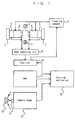
- FIG. 1 shows a traveling system of a robot in which an estimation device for a self-position according to the example is incorporated, and reference numerals 2, 2 denote a pair of drive wheels, each of which is rotated by a traveling motor 4 and a gear head 5, and the number of revolution of the motor 4 is monitored by an encoder 7, and inputted to a dead reckoning unit 9 described later. Moreover, a reduction rate of a gear of the gear head 5 and a type of normal rotation/reverse rotation are also inputted to the dead reckoning unit 9.
- Reference numerals 3, 3 denote a pair of caster wheels.
- a traveling command generator 8 independently controls rotation amounts and rotation directions of the drive wheels 2, 2 by independently controlling the traveling motors 4, 4 and the gear head units 5, 5 to move the robot to a target position.
- a walking type robot in place of the drive wheels 2 and the caster wheels 3, legs constructed by combination of joints may be used.
- a type of the mobile unit may be a carrying vehicle, a transfer device or the like besides the robot, and a mechanism of movement itself is arbitrary.
- the encoders 7, 7 are one example of internal sensors, signals thereof are inputted to the dead reckoning unit 9, and a moving distance is integrated to thereby find the self-position. Finding the self-position by the signals of the internal sensors is referred to as dead reckoning.
- the found position is stored in a position storage 10, every time a more accurate position is estimated by a position estimating unit 16, the found position is updated, and based on the data of the position storage 10, the traveling command generator 8 generates a traveling command.
- a map 12 is a map having a range where the mobile unit such as the robot can be moved, and the movable range is in doors, inside a building, out of doors or the like.
- an edge perpendicular to a floor surface is set as a landmark, a position of the landmark and a break between a horizontal surface and a vertical surface, such as a border between a floor and a wall are stored in the map 12.
- the edge perpendicular to the floor surface includes, for example, edges of furniture and a locker, and vertical edges of a door and a window.
- a Z direction (vertical) coordinate may be added, so that a Z-axis direction coordinate Z0 as an origin of the landmark and a Z-axis direction coordinate Z1 as a terminal of the landmark may be added.
- the break includes not only the break between the floor and the wall, but also the break occurs in a position where an object rises with respect to the floor surface, that is, at an end portion of the floor surface. Moreover, the break occurs at a border between a driveway and a sidewalk, at a border between a sidewalk and a flowerbed, or at a border between a sidewalk and a gully.
- the break on the map 12 is represented by a curve or a line segment, and only a break having a height of floor surface level may be used, or a break in a higher position, for example, an edge between an upper surface and a side surface of a step rising from the floor surface may also be used.
- the creation of the map 12 is, for example, performed manually, or a wide-angle camera image captured in a known position with respect to a movement space of the mobile unit indoors, inside of a building, in the vicinity of entrance of a building or the like may be recognized to create the map 12.
- Reference numeral 13 denotes a mirror
- reference numeral 14 denotes a camera, and the combination of them is referred to as a wide-angle camera.
- An output image of the wide-angle camera is stored in a camera image storage 15, and in the position estimating unit 16, a self-position of the mobile unit is estimated using the data of the position storage 10, and the map 12, and the camera image.
- Data of the self-position is composed of three components of (X, Y) coordinates with respect to an origin, and an orientation of the mobile unit, for example.
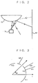
- Fig. 2 shows a state where a landmark M perpendicular to the floor surface is imaged by the camera 14, and if a height position in the landmark M made of a vertical line segment is different, light enters in a different position on a line segment along a radial direction from a center of a visual field of the camera 14.
- Fig. 3 schematically shows how three landmarks M1 to M3 and three breaks N1 to N3 appear in the wide-angle camera image.
- Reference numeral r represents a radial direction
- ⁇ represents an orientation
- the breaks N1 to N3 are, for example, represented by curves in a circumferential direction, the radial position of which is substantially constant.
- a landmark matching unit 20 associates three landmarks extracted from the camera image and three landmarks extracted from the map 12 on a one-on-one basis, and based on this correspondence, a self-position is estimated.
- the estimated self-position is based on the correspondence relation between the assumed landmarks.
- a landmark error evaluating unit 22 evaluates an error based on the estimated self-position using a landmark not used for the estimation of the self-position. Namely, when the self-position is estimated, in which orientation the other landmark on the map 12 is seen on the wide-angle camera image can be estimated, the error between the above-described orientation and that of the actual camera image can be evaluated.
- the landmark error evaluating unit 22 may not be provided.
- a break projecting unit 24 projects, onto the wide-angle camera image, the break on the map 12 based on the self-position estimated by the matching of the landmarks. Once the self-position is estimated, how the break on the map 12 is seen in the wide-angle camera image can be estimated based on this, which is referred to as break projection.
- a break projecting unit 26 projects how the break on the map 12 is seen on the wide-angle camera image, based on the position stored in the position storage 10, in other words, the self-position found by the dead reckoning using the encoder 7. The break projecting unit 26 may not be provided.
- a break matching unit 28 performs matching between the break projected by the break matching unit 24 and the break in the wide-angle camera image.
- the break projected by the projecting unit 24, and the break projected by the projecting unit 26 are matched, in other words, a distance between the two breaks is calculated.
- This distance includes an additional value of errors in respective portions of the break, a sum of values obtained by converting the errors in the respective portions of the break using an appropriate function and the like.
- a position estimating unit 30 verifies validity of an estimated value of the self position, based on a found error, and an estimated position the error of which is less than a predetermined value, or the error of which is enough small is outputted as the self-position. Otherwise, the combination of the landmark on the wide-angle camera image side and the landmark on the map side to be matched by the matching unit 20 is changed, and a series of processing up to that of the matching unit 28 is repeated.
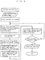
- an estimation algorism of the self-position is shown.
- An omnidirectional camera image is inputted, and for example, three candidates for landmarks are extracted from the camera image.
- the extraction may be randomly performed, or based on the data of the position storage unit 10, landmarks that should be seen from a current self-position may be extracted.
- three candidates for landmarks are extracted from the map, and are associated on a one-on-one basis. This association may be randomly performed, or feasible association on the data of the position storage 10 may be given priority.
- the three landmarks are associated between the wide-angle camera image and the map, one candidate for the self-position is found.
- An estimation error of the self-position is evaluated, for example, using another candidate and another landmark. This step may be omitted.
- a break on the map is projected onto the wide-angle camera image. While the landmark perpendicular to the floor surface provides data of one point on the floor surface, the break provides data of a straight line or a curve on the floor surface, which makes an information amount abundant. Accordingly, the matching of the breaks allows the error to be evaluated more accurately.
- the break on the map is projected onto the wide-angle camera image. This processing may be omitted, and if ever, it may be executed only for an area where the break projected based on the estimated value of the self-position, and the wide-angle camera image do not correspond to each other.
- an error between the break obtained by projecting the break on the map based on the estimated self-position and the break in the wide-angle camera image is evaluated.
- the break obtained by projecting the break on the map based on the position found by dead reckoning, and the break obtained by projecting the break on the map in accordance with the self-position estimated by the landmark are compared. The error between them is found, and if the error is within an acceptable range, the estimated position is outputted as a correct self-position to update the data of the position storage 10.
- a self-position estimating program 60 is shown, in which a landmark matching order 62 extracts, for example, three candidates for landmarks in the wide-angle camera image and three landmarks on the map to temporarily associate them, respectively.
- a self-position candidate calculating order 63 calculates a candidate for a self-position based on the above-described correspondence.
- a landmark error evaluating order 64 evaluates an error between another landmark on the map and another candidate for the landmark in the wide-angle camera image, based on the calculated self-position. The landmark error evaluating order 64 may not be provided.
- a break projecting order 65 projects a break on the map onto the wide-angle camera image, based on the candidate for the estimated self-position.
- a break projecting order 66 projects the break on the map onto the wide-angle camera image, based on the position found by the dead reckoning, but the order 66 may not be provided.
- a break matching order 67 performs matching between the breaks to evaluate an error.
- a self-position estimating order 68 evaluates validity of the estimated self-position, based on the matching error of the break evaluated by the break matching order 67, and if it is valid, the position is outputted, while if it is invalid, the series of processing of the orders 62 to 67 is repeated.
- there are a plurality of breaks and for example, about several breaks exist indoors.
- the matching is performed for each of the breaks, the error includes an additional value of errors of the respective breaks, an amount of statistics obtained by turning the errors of the respective breaks into statistics, and the like.
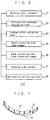
- Fig. 7 shows one example of the matching of the breaks.
- Reference numeral 70 denotes the break based on the estimation of the self-position and the map, which is the break obtained by projecting the break on the map onto the wide-angle camera image, based on the self-position estimated from the landmarks.
- Reference numeral 72 denotes the break in the camera image, in which a portion of the break is hidden by another object, or is lost due to lighting or the like.
- the break obtained by projecting the break on the map based on the self-position found by dead reckoning is shown as a break 74 from the dead reckoning.
- the resultant for example, from integrating distances of respective arrows in Fig. 7 is a matching error of the breaks.
- the error between the breaks 70,74 is an estimation error of the self-position, and reliability of position recognition by dead reckoning is low, resulting in a vague error.
- Both of the breaks 70, 74 are the resultant from projecting based on the map, and even in an area where the break 70 and the break 72 do not correspond to each other, the break 74 corresponding to the break 70 exists. Consequently, in an area where the breaks 70, 72 correspond to each other, the distances of arrows in Fig. 7 are added to evaluate the error, and in the area where the breaks 70, 72 do not correspond to each other, the errors between the breaks 70, 74 are added for evaluation.
- the errors may be simply integrated, or may be turned into statistics for evaluation. Moreover, in order to prevent an area where the error is extremely large from affecting the matching result, a function attenuating when the error becomes large may be set, and the errors may be multiplied by the function and then, added. An upper limit may be provided for the error. Furthermore, the error between the breaks 70, 74 may be used by multiplying the same by a weight smaller than 1.
Landscapes
- Physics & Mathematics (AREA)
- Engineering & Computer Science (AREA)
- General Physics & Mathematics (AREA)
- Radar, Positioning & Navigation (AREA)
- Remote Sensing (AREA)
- Electromagnetism (AREA)
- Computer Vision & Pattern Recognition (AREA)
- Theoretical Computer Science (AREA)
- Multimedia (AREA)
- Control Of Position, Course, Altitude, Or Attitude Of Moving Bodies (AREA)
- Navigation (AREA)
Claims (3)
- Eine Schätzvorrichtung zum Schätzen einer Position einer mobilen Einheit, die eine Weitwinkelkamera (13, 14) aufweist und eine Karte (12) einer Landmarke (M), Prüfen der Landmarke (M), die in einem Weitwinkelkamerabild gefunden wurde, gegenüber einer Landmarke auf der Karte (12), um eine eigene Position der mobilen Einheit zu schätzen, wobei die Vorrichtung dadurch gekennzeichnet ist, dass
ein Übergang (N) zwischen einer Ebene beziehungsweise einem Boden und einem Objekt, das senkrecht zu der Ebene ist, in der Karte (12) gespeichert ist;
Übereinstimmungsmittel (28) zum Beurteilen eines Fehlers zwischen einem Übergang (70), der durch eine Projektion des Übergangs, der in der Karte (12) gespeichert ist, auf das Weitwinkelkamerabild erhalten wurde, basierend auf der geschätzten eigenen Position, und einem Übergang (72) in dem Weitwinkelkamerabild, um die Gültigkeit der geschätzten eigenen Position zu bewerten; und wobei
die Übereinstimmungsmittel (28) einen Fehler beurteilen, wenn der Übergang (72) in dem Weitwinkelkamerabild dem Übergang (70) entspricht, der durch das Projizieren erhalten wurde, abwesend ist, und zwar zwischen einem Übergang (74), der durch das Projizieren auf das Weitwinkelkamerabild erhalten wurde, wobei der Übergang in der Karte (12) gespeichert ist, basierend auf einer eigenen Position, die durch einen internen Sensor der mobilen Einheit gefunden wurde, und dem Übergang (70), der basierend auf der geschätzten eigenen Position projiziert wurde. - Ein Schätzverfahren zum Schätzen einer Position einer mobilen Einheit, das eine Weitwinkelkamera (13, 14) und eine Karte (12) einer Landmarke (M) verwendet, und Prüfen der Landmarke (M), die von einem Weitwinkelkamerabild gefunden wurde gegenüber einer Landmarke (M) auf der Karte (12), um eine eigene Position der mobilen Einheit zu schätzen, wobei das Verfahren dadurch gekennzeichnet ist, dass:ein Übergang (N) zwischen einer Ebene beziehungsweise einem Boden und einem Objekt, das senkrecht zu der Ebene ist, in der Karte (12) gespeichert ist;Beurteilen eines Fehlers zwischen einem Übergang (70), der durch eine Projektion des Übergangs, der in der Karte (12) gespeichert ist, auf das Weitwinkelkamerabild erhalten wird, basierend auf der geschätzten eigenen Position, und einem Übergang (72) in dem Weitwinkelkamerabild, um die Gültigkeit der geschätzten eigenen Position zu bewerten; undwenn der Übergang (72) in dem Weitwinkelkamerabild dem Übergang (70) entspricht, der durch das Projizieren erhalten wurde, abwesend ist, Beurteilen eines Fehlers zwischen einem Übergang (74), der durch das Projizieren auf das Weitwinkelkamerabild erhalten wurde, wobei der Übergang in der Karte (12) gespeichert ist, basierend auf einer eigenen Position, die durch einen internen Sensor der mobilen Einheit gefunden wurde, und dem Übergang (70), der basierend auf der geschätzten eigenen Position projiziert wurde.
- Ein Schätzprogramm (60) zum Schätzen einer Position einer mobilen Einheit zum Schätzen einer eigenen Position der mobilen Einheit unter der Bezugnahme auf ein Bild von einer Weitwinkelkamera (13, 14) und auf eine Karte einer Landmarke (M), und Prüfen der Landmarke (M), die in einem Weitwinkelkamerabild gefunden wurde, gegenüber einer Landmarke auf einer Karte (12), wobei das Programm die mobile Einheit dazu bringt die folgenden Schritte auszuführen:eine Anweisung (63) zum Extrahieren der Landmarke (M) aus dem Weitwinkelkamerabild und Prüfen desselben gegenüber der Landmarke auf der Karte (12), um dadurch die eigene Position der mobilen Einheit zu schätzen;eine Anweisung zum Auslesen eines Übergangs (N) zwischen einer Ebene beziehungsweise einem Boden und einem Objekt, das senkrecht zu der Ebene ist, und die in der Karte (12) gespeichert ist; undeine Übereinstimmungsanweisung (67) zum Beurteilen eines Fehlers zwischen einem Übergang (70), der durch eine Projektion des Übergangs, der in der Karte (12) gespeichert ist, auf das Weitwinkelkamerabild erhalten wurde, basierend auf der geschätzten eigenen Position, und einem Übergang (72) in dem Weitwinkelkamerabild, um die Gültigkeit der geschätzten eigenen Position zu bewerten; und wenn der Übergang (72) in dem Weitwinkelkamerabild dem Übergang (70) entspricht, der durch das Projizieren erhalten wurde, abwesend ist, Beurteilen eines Fehlers zwischen einem Übergang (74), der durch das Projizieren auf das Weitwinkelkamerabild erhalten wurde, wobei der Übergang in der Karte (12) gespeichert ist, basierend auf einer eigenen Position, die durch einen internen Sensor der mobilen Einheit gefunden wurde, und des Übergangs (70), der basierend auf der geschätzten eigenen Position projiziert wurde.
Applications Claiming Priority (2)
| Application Number | Priority Date | Filing Date | Title |
|---|---|---|---|
| JP2006097422 | 2006-03-31 | ||
| PCT/JP2007/053746 WO2007113956A1 (ja) | 2006-03-31 | 2007-02-28 | 移動体位置の推定装置と推定方法及び推定プログラム |
Publications (3)
| Publication Number | Publication Date |
|---|---|
| EP2017573A1 EP2017573A1 (de) | 2009-01-21 |
| EP2017573A4 EP2017573A4 (de) | 2012-10-31 |
| EP2017573B1 true EP2017573B1 (de) | 2013-11-20 |
Family
ID=38563228
Family Applications (1)
| Application Number | Title | Priority Date | Filing Date |
|---|---|---|---|
| EP07737500.4A Not-in-force EP2017573B1 (de) | 2006-03-31 | 2007-02-28 | Vorrichtung, verfahren und programm zur positionsschätzung einer mobilen einheit |
Country Status (5)
| Country | Link |
|---|---|
| US (1) | US8204643B2 (de) |
| EP (1) | EP2017573B1 (de) |
| JP (1) | JP4753103B2 (de) |
| KR (1) | KR101013392B1 (de) |
| WO (1) | WO2007113956A1 (de) |
Families Citing this family (15)
| Publication number | Priority date | Publication date | Assignee | Title |
|---|---|---|---|---|
| EP2104921B1 (de) * | 2006-11-28 | 2018-07-11 | Koninklijke Philips N.V. | Verfahren, vorrichtung und computerprogamm zur datenverarbeitung |
| KR101503904B1 (ko) * | 2008-07-07 | 2015-03-19 | 삼성전자 주식회사 | 이동 로봇의 지도 구성 장치 및 방법 |
| US9930252B2 (en) | 2012-12-06 | 2018-03-27 | Toyota Motor Engineering & Manufacturing North America, Inc. | Methods, systems and robots for processing omni-directional image data |
| US9536152B2 (en) * | 2013-02-14 | 2017-01-03 | Xerox Corporation | Methods and systems for multimedia trajectory annotation |
| WO2015049717A1 (ja) * | 2013-10-01 | 2015-04-09 | 株式会社日立製作所 | 移動体位置推定装置および移動体位置推定方法 |
| US20150293533A1 (en) * | 2014-04-13 | 2015-10-15 | Bobsweep Inc. | Scanned Code Instruction and Confinement Sytem for Mobile Electronic Devices |
| JP6343670B2 (ja) * | 2014-07-30 | 2018-06-13 | 株式会社日立製作所 | 自律移動装置及び自己位置推定方法 |
| DE102016217637B4 (de) | 2016-09-15 | 2025-05-15 | Volkswagen Aktiengesellschaft | Odometrie-Verfahren zum Ermitteln einer Position eines Kraftfahrzeugs, Steuervorrichtung und Kraftfahrzeug |
| JP7127303B2 (ja) | 2018-03-09 | 2022-08-30 | カシオ計算機株式会社 | 自律移動装置、自律移動方法及びプログラム |
| US10824923B1 (en) * | 2019-01-23 | 2020-11-03 | Facebook Technologies, Llc | System and method for improving localization and object tracking |
| CN112101378B (zh) * | 2020-08-20 | 2024-08-02 | 上海姜歌机器人有限公司 | 机器人重定位方法、装置及设备 |
| US11461971B1 (en) * | 2021-03-25 | 2022-10-04 | Cesium GS, Inc. | Systems and methods for interactively extrapolating breaklines over surfaces |
| KR102556767B1 (ko) * | 2022-06-28 | 2023-07-18 | 주식회사 브이알크루 | 비주얼 로컬라이제이션을 위한 방법 및 장치 |
| KR20240004102A (ko) * | 2022-07-04 | 2024-01-11 | 주식회사 브이알크루 | 비주얼 로컬라이제이션을 위한 방법 및 장치 |
| KR102556765B1 (ko) * | 2022-07-04 | 2023-07-18 | 주식회사 브이알크루 | 비주얼 로컬라이제이션을 위한 방법 및 장치 |
Family Cites Families (17)
| Publication number | Priority date | Publication date | Assignee | Title |
|---|---|---|---|---|
| US4940925A (en) * | 1985-08-30 | 1990-07-10 | Texas Instruments Incorporated | Closed-loop navigation system for mobile robots |
| US4933864A (en) * | 1988-10-04 | 1990-06-12 | Transitions Research Corporation | Mobile robot navigation employing ceiling light fixtures |
| US5051906A (en) * | 1989-06-07 | 1991-09-24 | Transitions Research Corporation | Mobile robot navigation employing retroreflective ceiling features |
| US5525883A (en) * | 1994-07-08 | 1996-06-11 | Sara Avitzour | Mobile robot location determination employing error-correcting distributed landmarks |
| JPH08247775A (ja) * | 1995-03-15 | 1996-09-27 | Toshiba Corp | 移動体の自己位置同定装置および自己位置同定方法 |
| JPH0953939A (ja) | 1995-08-18 | 1997-02-25 | Fujitsu Ltd | 自走車の自己位置測定装置および自己位置測定方法 |
| JP3833786B2 (ja) * | 1997-08-04 | 2006-10-18 | 富士重工業株式会社 | 移動体の3次元自己位置認識装置 |
| CA2373669A1 (en) * | 2002-02-27 | 2003-08-27 | Indal Technologies Inc. | Imaging system for a passenger bridge of the like for docking automatically with an aircraft |
| JP2003263104A (ja) * | 2002-03-11 | 2003-09-19 | Mitsubishi Electric Corp | 撮像情報認識システム |
| US6825485B1 (en) * | 2002-05-08 | 2004-11-30 | Storage Technology Corporation | System and method for aligning a robot device in a data storage library |
| JP2004034272A (ja) | 2002-07-08 | 2004-02-05 | Mitsubishi Heavy Ind Ltd | 移動体の自己位置同定装置 |
| KR100493159B1 (ko) * | 2002-10-01 | 2005-06-02 | 삼성전자주식회사 | 이동체의 효율적 자기 위치 인식을 위한 랜드마크 및 이를이용한 자기 위치 인식 장치 및 방법 |
| US20050234679A1 (en) * | 2004-02-13 | 2005-10-20 | Evolution Robotics, Inc. | Sequential selective integration of sensor data |
| JP4264380B2 (ja) * | 2004-04-28 | 2009-05-13 | 三菱重工業株式会社 | 自己位置同定方法及び該装置 |
| JP2005325746A (ja) | 2004-05-13 | 2005-11-24 | Toyota Industries Corp | 車両用排熱回収システム |
| KR100809342B1 (ko) * | 2004-10-05 | 2008-03-05 | 삼성전자주식회사 | 조도기반 네비게이션 장치 및 방법 |
| US7191056B2 (en) * | 2005-01-04 | 2007-03-13 | The Boeing Company | Precision landmark-aided navigation |
-
2007
- 2007-02-28 KR KR1020087022761A patent/KR101013392B1/ko not_active Expired - Fee Related
- 2007-02-28 EP EP07737500.4A patent/EP2017573B1/de not_active Not-in-force
- 2007-02-28 JP JP2008508464A patent/JP4753103B2/ja not_active Expired - Fee Related
- 2007-02-28 WO PCT/JP2007/053746 patent/WO2007113956A1/ja not_active Ceased
- 2007-02-28 US US12/295,088 patent/US8204643B2/en not_active Expired - Fee Related
Also Published As
| Publication number | Publication date |
|---|---|
| US20090248305A1 (en) | 2009-10-01 |
| KR101013392B1 (ko) | 2011-02-14 |
| EP2017573A1 (de) | 2009-01-21 |
| JPWO2007113956A1 (ja) | 2009-08-13 |
| US8204643B2 (en) | 2012-06-19 |
| WO2007113956A1 (ja) | 2007-10-11 |
| EP2017573A4 (de) | 2012-10-31 |
| JP4753103B2 (ja) | 2011-08-24 |
| KR20080106930A (ko) | 2008-12-09 |
Similar Documents
| Publication | Publication Date | Title |
|---|---|---|
| EP2017573B1 (de) | Vorrichtung, verfahren und programm zur positionsschätzung einer mobilen einheit | |
| US20090312871A1 (en) | System and method for calculating location using a combination of odometry and landmarks | |
| CN102596517B (zh) | 移动机器人定位和导航控制方法及使用该方法的移动机器人 | |
| US9587948B2 (en) | Method for determining the absolute position of a mobile unit, and mobile unit | |
| US9310807B2 (en) | Method and system for creating indoor environment map | |
| JP5588812B2 (ja) | 画像処理装置及びそれを用いた撮像装置 | |
| US8508527B2 (en) | Apparatus and method of building map for mobile robot | |
| KR101782057B1 (ko) | 지도 생성 장치 및 방법 | |
| CN105814404B (zh) | 用于定位移动设备的方法和系统 | |
| US8807428B2 (en) | Navigation of mobile devices | |
| US10061324B2 (en) | Autonomous moving device and self position estimation method | |
| CN116907458A (zh) | 基于光学目标的室内车辆导航的系统和方法 | |
| JPH03201110A (ja) | 自律走行車の位置方位検出装置 | |
| JP4798450B2 (ja) | ナビゲーション装置とその制御方法 | |
| Hoang et al. | Multi-sensor perceptual system for mobile robot and sensor fusion-based localization | |
| US11392136B2 (en) | Automated guided vehicle system and own-position estimation method for automated guided vehicle | |
| JP2009070357A (ja) | 移動体の誘導システム | |
| Kim et al. | Indoor localization using laser scanner and vision marker for intelligent robot | |
| Zhang et al. | A vision/inertia integrated positioning method using position and orientation matching | |
| US20250245853A1 (en) | System and method for generating code block map based on floor pattern recognition and system and method for recognizing location and orientation of robot based on floor pattern code string | |
| Launay et al. | Vision-based navigation of mobile robot using fluorescent tubes | |
| Hong et al. | An Indoor Location Tracking System Based on Wireless Sensor Networks and Marker-Based Fingerprinting Algorithm | |
| KR20090119049A (ko) | 자기 위치 인식을 위한 이동 로봇의 기본 움직임 결정 방법 |
Legal Events
| Date | Code | Title | Description |
|---|---|---|---|
| PUAI | Public reference made under article 153(3) epc to a published international application that has entered the european phase |
Free format text: ORIGINAL CODE: 0009012 |
|
| 17P | Request for examination filed |
Effective date: 20080910 |
|
| AK | Designated contracting states |
Kind code of ref document: A1 Designated state(s): AT BE BG CH CY CZ DE DK EE ES FI FR GB GR HU IE IS IT LI LT LU LV MC NL PL PT RO SE SI SK TR |
|
| AX | Request for extension of the european patent |
Extension state: AL BA HR MK RS |
|
| DAX | Request for extension of the european patent (deleted) | ||
| A4 | Supplementary search report drawn up and despatched |
Effective date: 20120927 |
|
| RIC1 | Information provided on ipc code assigned before grant |
Ipc: G01C 15/00 20060101AFI20120921BHEP Ipc: G01S 5/16 20060101ALI20120921BHEP Ipc: G05D 1/02 20060101ALI20120921BHEP Ipc: G06T 7/00 20060101ALI20120921BHEP |
|
| GRAP | Despatch of communication of intention to grant a patent |
Free format text: ORIGINAL CODE: EPIDOSNIGR1 |
|
| INTG | Intention to grant announced |
Effective date: 20130528 |
|
| GRAS | Grant fee paid |
Free format text: ORIGINAL CODE: EPIDOSNIGR3 |
|
| GRAA | (expected) grant |
Free format text: ORIGINAL CODE: 0009210 |
|
| AK | Designated contracting states |
Kind code of ref document: B1 Designated state(s): AT BE BG CH CY CZ DE DK EE ES FI FR GB GR HU IE IS IT LI LT LU LV MC NL PL PT RO SE SI SK TR |
|
| REG | Reference to a national code |
Ref country code: GB Ref legal event code: FG4D |
|
| REG | Reference to a national code |
Ref country code: CH Ref legal event code: EP |
|
| REG | Reference to a national code |
Ref country code: AT Ref legal event code: REF Ref document number: 641897 Country of ref document: AT Kind code of ref document: T Effective date: 20131215 |
|
| REG | Reference to a national code |
Ref country code: IE Ref legal event code: FG4D |
|
| REG | Reference to a national code |
Ref country code: DE Ref legal event code: R096 Ref document number: 602007033885 Country of ref document: DE Effective date: 20140116 |
|
| REG | Reference to a national code |
Ref country code: NL Ref legal event code: VDEP Effective date: 20131120 |
|
| REG | Reference to a national code |
Ref country code: AT Ref legal event code: MK05 Ref document number: 641897 Country of ref document: AT Kind code of ref document: T Effective date: 20131120 |
|
| REG | Reference to a national code |
Ref country code: LT Ref legal event code: MG4D |
|
| PG25 | Lapsed in a contracting state [announced via postgrant information from national office to epo] |
Ref country code: LT Free format text: LAPSE BECAUSE OF FAILURE TO SUBMIT A TRANSLATION OF THE DESCRIPTION OR TO PAY THE FEE WITHIN THE PRESCRIBED TIME-LIMIT Effective date: 20131120 Ref country code: IS Free format text: LAPSE BECAUSE OF FAILURE TO SUBMIT A TRANSLATION OF THE DESCRIPTION OR TO PAY THE FEE WITHIN THE PRESCRIBED TIME-LIMIT Effective date: 20140320 Ref country code: FI Free format text: LAPSE BECAUSE OF FAILURE TO SUBMIT A TRANSLATION OF THE DESCRIPTION OR TO PAY THE FEE WITHIN THE PRESCRIBED TIME-LIMIT Effective date: 20131120 Ref country code: NL Free format text: LAPSE BECAUSE OF FAILURE TO SUBMIT A TRANSLATION OF THE DESCRIPTION OR TO PAY THE FEE WITHIN THE PRESCRIBED TIME-LIMIT Effective date: 20131120 Ref country code: SE Free format text: LAPSE BECAUSE OF FAILURE TO SUBMIT A TRANSLATION OF THE DESCRIPTION OR TO PAY THE FEE WITHIN THE PRESCRIBED TIME-LIMIT Effective date: 20131120 |
|
| PG25 | Lapsed in a contracting state [announced via postgrant information from national office to epo] |
Ref country code: BE Free format text: LAPSE BECAUSE OF FAILURE TO SUBMIT A TRANSLATION OF THE DESCRIPTION OR TO PAY THE FEE WITHIN THE PRESCRIBED TIME-LIMIT Effective date: 20131120 Ref country code: AT Free format text: LAPSE BECAUSE OF FAILURE TO SUBMIT A TRANSLATION OF THE DESCRIPTION OR TO PAY THE FEE WITHIN THE PRESCRIBED TIME-LIMIT Effective date: 20131120 Ref country code: LV Free format text: LAPSE BECAUSE OF FAILURE TO SUBMIT A TRANSLATION OF THE DESCRIPTION OR TO PAY THE FEE WITHIN THE PRESCRIBED TIME-LIMIT Effective date: 20131120 Ref country code: ES Free format text: LAPSE BECAUSE OF FAILURE TO SUBMIT A TRANSLATION OF THE DESCRIPTION OR TO PAY THE FEE WITHIN THE PRESCRIBED TIME-LIMIT Effective date: 20131120 |
|
| PG25 | Lapsed in a contracting state [announced via postgrant information from national office to epo] |
Ref country code: PT Free format text: LAPSE BECAUSE OF FAILURE TO SUBMIT A TRANSLATION OF THE DESCRIPTION OR TO PAY THE FEE WITHIN THE PRESCRIBED TIME-LIMIT Effective date: 20140320 |
|
| PG25 | Lapsed in a contracting state [announced via postgrant information from national office to epo] |
Ref country code: EE Free format text: LAPSE BECAUSE OF FAILURE TO SUBMIT A TRANSLATION OF THE DESCRIPTION OR TO PAY THE FEE WITHIN THE PRESCRIBED TIME-LIMIT Effective date: 20131120 |
|
| REG | Reference to a national code |
Ref country code: DE Ref legal event code: R097 Ref document number: 602007033885 Country of ref document: DE |
|
| PG25 | Lapsed in a contracting state [announced via postgrant information from national office to epo] |
Ref country code: CZ Free format text: LAPSE BECAUSE OF FAILURE TO SUBMIT A TRANSLATION OF THE DESCRIPTION OR TO PAY THE FEE WITHIN THE PRESCRIBED TIME-LIMIT Effective date: 20131120 Ref country code: PL Free format text: LAPSE BECAUSE OF FAILURE TO SUBMIT A TRANSLATION OF THE DESCRIPTION OR TO PAY THE FEE WITHIN THE PRESCRIBED TIME-LIMIT Effective date: 20131120 Ref country code: RO Free format text: LAPSE BECAUSE OF FAILURE TO SUBMIT A TRANSLATION OF THE DESCRIPTION OR TO PAY THE FEE WITHIN THE PRESCRIBED TIME-LIMIT Effective date: 20131120 Ref country code: SK Free format text: LAPSE BECAUSE OF FAILURE TO SUBMIT A TRANSLATION OF THE DESCRIPTION OR TO PAY THE FEE WITHIN THE PRESCRIBED TIME-LIMIT Effective date: 20131120 |
|
| PLBE | No opposition filed within time limit |
Free format text: ORIGINAL CODE: 0009261 |
|
| STAA | Information on the status of an ep patent application or granted ep patent |
Free format text: STATUS: NO OPPOSITION FILED WITHIN TIME LIMIT |
|
| PG25 | Lapsed in a contracting state [announced via postgrant information from national office to epo] |
Ref country code: MC Free format text: LAPSE BECAUSE OF FAILURE TO SUBMIT A TRANSLATION OF THE DESCRIPTION OR TO PAY THE FEE WITHIN THE PRESCRIBED TIME-LIMIT Effective date: 20131120 Ref country code: DK Free format text: LAPSE BECAUSE OF FAILURE TO SUBMIT A TRANSLATION OF THE DESCRIPTION OR TO PAY THE FEE WITHIN THE PRESCRIBED TIME-LIMIT Effective date: 20131120 Ref country code: LU Free format text: LAPSE BECAUSE OF FAILURE TO SUBMIT A TRANSLATION OF THE DESCRIPTION OR TO PAY THE FEE WITHIN THE PRESCRIBED TIME-LIMIT Effective date: 20140228 |
|
| REG | Reference to a national code |
Ref country code: CH Ref legal event code: PL |
|
| 26N | No opposition filed |
Effective date: 20140821 |
|
| GBPC | Gb: european patent ceased through non-payment of renewal fee |
Effective date: 20140228 |
|
| PG25 | Lapsed in a contracting state [announced via postgrant information from national office to epo] |
Ref country code: LI Free format text: LAPSE BECAUSE OF NON-PAYMENT OF DUE FEES Effective date: 20140228 Ref country code: CH Free format text: LAPSE BECAUSE OF NON-PAYMENT OF DUE FEES Effective date: 20140228 |
|
| REG | Reference to a national code |
Ref country code: FR Ref legal event code: ST Effective date: 20141031 |
|
| REG | Reference to a national code |
Ref country code: IE Ref legal event code: MM4A |
|
| REG | Reference to a national code |
Ref country code: DE Ref legal event code: R097 Ref document number: 602007033885 Country of ref document: DE Effective date: 20140821 |
|
| PG25 | Lapsed in a contracting state [announced via postgrant information from national office to epo] |
Ref country code: GB Free format text: LAPSE BECAUSE OF NON-PAYMENT OF DUE FEES Effective date: 20140228 Ref country code: FR Free format text: LAPSE BECAUSE OF NON-PAYMENT OF DUE FEES Effective date: 20140228 Ref country code: IE Free format text: LAPSE BECAUSE OF NON-PAYMENT OF DUE FEES Effective date: 20140228 |
|
| PG25 | Lapsed in a contracting state [announced via postgrant information from national office to epo] |
Ref country code: SI Free format text: LAPSE BECAUSE OF FAILURE TO SUBMIT A TRANSLATION OF THE DESCRIPTION OR TO PAY THE FEE WITHIN THE PRESCRIBED TIME-LIMIT Effective date: 20131120 |
|
| PG25 | Lapsed in a contracting state [announced via postgrant information from national office to epo] |
Ref country code: IT Free format text: LAPSE BECAUSE OF FAILURE TO SUBMIT A TRANSLATION OF THE DESCRIPTION OR TO PAY THE FEE WITHIN THE PRESCRIBED TIME-LIMIT Effective date: 20131120 |
|
| PGFP | Annual fee paid to national office [announced via postgrant information from national office to epo] |
Ref country code: DE Payment date: 20160218 Year of fee payment: 10 |
|
| PG25 | Lapsed in a contracting state [announced via postgrant information from national office to epo] |
Ref country code: BG Free format text: LAPSE BECAUSE OF FAILURE TO SUBMIT A TRANSLATION OF THE DESCRIPTION OR TO PAY THE FEE WITHIN THE PRESCRIBED TIME-LIMIT Effective date: 20131120 |
|
| PG25 | Lapsed in a contracting state [announced via postgrant information from national office to epo] |
Ref country code: CY Free format text: LAPSE BECAUSE OF FAILURE TO SUBMIT A TRANSLATION OF THE DESCRIPTION OR TO PAY THE FEE WITHIN THE PRESCRIBED TIME-LIMIT Effective date: 20131120 Ref country code: GR Free format text: LAPSE BECAUSE OF FAILURE TO SUBMIT A TRANSLATION OF THE DESCRIPTION OR TO PAY THE FEE WITHIN THE PRESCRIBED TIME-LIMIT Effective date: 20140221 |
|
| PG25 | Lapsed in a contracting state [announced via postgrant information from national office to epo] |
Ref country code: HU Free format text: LAPSE BECAUSE OF FAILURE TO SUBMIT A TRANSLATION OF THE DESCRIPTION OR TO PAY THE FEE WITHIN THE PRESCRIBED TIME-LIMIT; INVALID AB INITIO Effective date: 20070228 Ref country code: TR Free format text: LAPSE BECAUSE OF FAILURE TO SUBMIT A TRANSLATION OF THE DESCRIPTION OR TO PAY THE FEE WITHIN THE PRESCRIBED TIME-LIMIT Effective date: 20131120 |
|
| REG | Reference to a national code |
Ref country code: DE Ref legal event code: R119 Ref document number: 602007033885 Country of ref document: DE |
|
| PG25 | Lapsed in a contracting state [announced via postgrant information from national office to epo] |
Ref country code: DE Free format text: LAPSE BECAUSE OF NON-PAYMENT OF DUE FEES Effective date: 20170901 |