EP1998143A2 - System und Verfahren zur Routeneinstellung sowie Programm zur Ausführung des Verfahrens - Google Patents
System und Verfahren zur Routeneinstellung sowie Programm zur Ausführung des Verfahrens Download PDFInfo
- Publication number
- EP1998143A2 EP1998143A2 EP08156645A EP08156645A EP1998143A2 EP 1998143 A2 EP1998143 A2 EP 1998143A2 EP 08156645 A EP08156645 A EP 08156645A EP 08156645 A EP08156645 A EP 08156645A EP 1998143 A2 EP1998143 A2 EP 1998143A2
- Authority
- EP
- European Patent Office
- Prior art keywords
- road
- map
- processing means
- route
- roads
- Prior art date
- Legal status (The legal status is an assumption and is not a legal conclusion. Google has not performed a legal analysis and makes no representation as to the accuracy of the status listed.)
- Withdrawn
Links
- 238000000034 method Methods 0.000 title claims description 49
- 238000012545 processing Methods 0.000 claims abstract description 66
- 230000008569 process Effects 0.000 description 29
- 238000010586 diagram Methods 0.000 description 13
- 238000004891 communication Methods 0.000 description 8
- 230000015654 memory Effects 0.000 description 6
- 230000008859 change Effects 0.000 description 5
- 238000012790 confirmation Methods 0.000 description 4
- 230000005540 biological transmission Effects 0.000 description 2
- 238000001514 detection method Methods 0.000 description 2
- 230000006870 function Effects 0.000 description 2
- 230000004913 activation Effects 0.000 description 1
- 230000015572 biosynthetic process Effects 0.000 description 1
- 238000010348 incorporation Methods 0.000 description 1
- 239000004973 liquid crystal related substance Substances 0.000 description 1
- 238000012986 modification Methods 0.000 description 1
- 230000004048 modification Effects 0.000 description 1
- 230000003287 optical effect Effects 0.000 description 1
- 238000003786 synthesis reaction Methods 0.000 description 1
- 230000003936 working memory Effects 0.000 description 1
Images



Classifications
-
- G—PHYSICS
- G01—MEASURING; TESTING
- G01C—MEASURING DISTANCES, LEVELS OR BEARINGS; SURVEYING; NAVIGATION; GYROSCOPIC INSTRUMENTS; PHOTOGRAMMETRY OR VIDEOGRAMMETRY
- G01C21/00—Navigation; Navigational instruments not provided for in groups G01C1/00 - G01C19/00
- G01C21/26—Navigation; Navigational instruments not provided for in groups G01C1/00 - G01C19/00 specially adapted for navigation in a road network
- G01C21/34—Route searching; Route guidance
- G01C21/36—Input/output arrangements for on-board computers
- G01C21/3667—Display of a road map
- G01C21/367—Details, e.g. road map scale, orientation, zooming, illumination, level of detail, scrolling of road map or positioning of current position marker
Definitions
- the present invention relates to a route setting system, a route setting method, and a program for executing the method.
- a route search process is performed on the basis of the search condition to search for a route from the place of departure indicated by the current location to the destination on the basis of map data.
- the route found by the search i.e., the searched route is displayed on a map screen formed on a display unit together with a vehicle position representing the current location of a vehicle, to thereby perform the guidance along the searched route, i.e., the route guidance.
- the route guidance by an audio output is also performed.
- the driver can drive the vehicle along the displayed searched route.
- a navigation device has been provided in which a predetermined road on the map screen of the display unit formed by a touch panel is set as the driving route to the destination by the tracing with a finger along the road without the execution of the search operation of the route (see Japanese Unexamined Patent Application Publication No. 2000-111354 , for example).
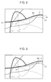
- Fig. 2 is a first diagram for explaining a conventional driving route setting method
- Fig. 3 is a second diagram for explaining the conventional driving route setting method.
- r1 and r11, Rt1 and Rt2, s1, and e1 indicate roads, driving routes, a tracing start point representing the start point of the tracing, and a tracing end point representing the end point of the tracing, respectively.
- the road r11 branches from the road r1 at a branch point p1.
- a finger of the driver fails to accurately touch the area of the road r1 on the touch panel when the driver performs the tracing with the finger along the road r1 from the tracing start point s1 to the tracing end point e1 to set the road r1 as the driving route Rt1
- a portion of the road r1 extending from the tracing start point s1 to the branch point p1 and a portion of the road r11 extending from the branch point p1 to the tracing end point e1 may be set as the driving route R2, as illustrated in Fig. 3 , for example.
- a route setting system includes scale determination processing means for reading the scale of a map displayed on a map screen, matching target road selection processing means for selecting, in accordance with the scale of the map, matching target roads which are target roads used for setting a driving route, specification determination processing means for determining whether or not a road has been specified by an operator, and road selection processing means for selecting, if the road has been specified by the operator, one of the matching target roads nearest to a specified point as a road used for setting the driving route.
- one of the matching target roads nearest to the specified point is selected as the road used for setting the driving route. Therefore, a predetermined road can be accurately set as the driving route.
- Fig. 1 is a diagram illustrating a navigation system of an embodiment of the present invention
- Fig. 2 is a first diagram for explaining a conventional driving route setting method
- Fig. 3 is a second diagram for explaining the conventional driving route setting method
- Fig. 4 is a flowchart illustrating a driving route setting method of the embodiment of the present invention.
- Fig. 5 is a diagram illustrating the types of roads of the embodiment of the present invention.
- Fig. 6 is a diagram for explaining the driving route setting method of the embodiment of the present invention.
- Fig. 7 is a diagram illustrating an example of a matching target road map of the embodiment of the present invention.
- Fig. 1 is a diagram illustrating a navigation system of an embodiment of the present invention.
- reference numerals 14, 63, and 51 indicate an information terminal such as a navigation device serving as an in-vehicle device installed in a vehicle, for example, a network, and an information center serving as an information provider, respectively.
- the navigation device 14, the network 63, the information center 51, and so forth constitute the navigation system.
- the navigation device 14 includes a GPS (Global Positioning System) sensor 15, a data recording unit 16, a navigation processing unit 17, an operation unit 34, a display unit 35, an audio input unit 36, an audio output unit 37, and a communication unit 38.
- the GPS sensor 15 serves as a current location detection unit for detecting the current location of the vehicle as a vehicle position and the direction of the vehicle as a vehicle direction.
- the data recording unit 16 serves as an information recording unit in which not-illustrated map data and a variety of other information are recorded.
- the navigation processing unit 17 performs a variety of arithmetic processes such as a navigation process.
- the operation unit 34 serves as a first input unit used for a predetermined input performed through the operation of the unit by a driver, i.e., an operator.
- the display unit 35 serves as a first output unit for performing a variety of display operations with images displayed on a not-illustrated screen for notification to the driver.
- the audio input unit 36 serves as a second input unit used for a predetermined input performed by sound by the driver.
- the audio output unit 37 serves as a second output unit for performing an audio output to notify the driver of a variety of information.
- the communication unit 38 serves as a transmitting and receiving unit functioning as a communication terminal.
- the navigation processing unit 17 is connected to the GPS sensor 15, the data recording unit 16, the operation unit 34, the display unit 35, the audio input unit 36, the audio output unit 37, and the communication unit 38.
- the navigation processing unit 17 is further connected to, for example, a vehicle speed sensor 44 serving as a vehicle speed detection unit for detecting the vehicle speed.
- the GPS sensor 15 detects the time as well as the vehicle position and the vehicle direction.
- the vehicle direction can also be detected by a direction sensor provided independently of the GPS sensor 15.
- the data recording unit 16 includes a map database constituted by map data files, and the map data is recorded in the map database.
- the map data includes such data as intersection data relating to intersections (branch points), node data relating to nodes, road data relating to road links, search data processed for a search operation, and facility data relating to facilities.
- the map data further includes feature data relating to features on roads.
- the data recording unit 16 further includes such databases as a statistical database constituted by statistical data files and a driving history database constituted by driving history data files. Statistical data and driving history data are recorded in the statistical data files and the driving history data files, respectively, as result data.
- the data recording unit 16 includes a not-illustrated disk, such as a hard disk, a CD (Compact Disk), a DVD (Digital Versatile Disk), and an optical disk.
- the data recording unit 16 further includes a not-illustrated head for reading and writing a variety of data such as a read-and-write head.
- the data recording unit 16 can also include a memory card or the like. The disks, the memory card, and so forth constitute an external storage device.
- Such databases as the map database, the statistical database, and the driving history database, which are formed in the data recording unit 16 in the present embodiment, can also be provided in the information center 51.
- the navigation processing unit 17 includes a CPU (Central Processing Unit) 31, a RAM (Random Access Memory) 32, a ROM (Read-Only Memory) 33, a not-illustrated flash memory, and so forth.
- the CPU 31 serves as a control unit for controlling the entirety of the navigation device 14 and also as an arithmetic unit.
- the RAM 32 is used as a working memory when the CPU 31 performs the variety of arithmetic processes.
- the ROM 33 is recorded with a control program and a variety of other programs for performing such operations as the search of the route to the destination and a route guidance.
- the flash memory is used to record a variety of data, programs, and so forth.
- the RAM 32, the ROM 33, the flash memory, and so forth constitute an internal storage device.
- a keyboard, a mouse, and so forth which are not illustrated, can be used.
- the display unit 35 a touch panel is used. A variety of screens formed on the display unit 35 can display thereon the vehicle position, the vehicle direction, a map, a searched route, guidance information along the searched route, traffic information, the distance to the next intersection on the searched route, the direction of travel at the next intersection, and so forth. Further, the display unit 35 also functions as an operation unit. Thus, a predetermined input operation can be performed by a touch on an image operation unit displayed on one of the screens in the form of an image, which includes a variety of keys, switches, buttons, and so forth.
- the audio input unit 36 is constituted by a not-illustrated microphone and so forth so that necessary information can be input in the unit by sound.
- the audio output unit 37 includes a sound synthesis device and a speaker, which are not illustrated, to perform the route guidance along the searched route by the audio output.
- the communication unit 38 includes such receivers as a not-illustrated beacon receiver and a not-illustrated FM (Frequency Modulation) receiver.
- the beacon receiver receives a variety of information such as current traffic information transmitted from a road traffic information center and general information.
- the FM receiver receives information as FM multiplex broadcasting via an FM broadcast station.
- the communication unit 38 can receive such data as the map data, the statistical data, and the driving history data from the information center 51 via the network 63.
- the information center 51 includes a server 53, a communication unit 57 connected to the server 53, a database (DB) 58 serving as an information recording unit, and so forth.
- the server 53 includes a CPU 54 serving as a control unit and as an arithmetic unit, a RAM 55, a ROM 56, and so forth. Further, data similar to the variety of data recorded in the data recording unit 16 is recorded in the database 58.
- Each of such components as the navigation system, the navigation processing unit 17, the CPU 31, the CPU 54, and the server 53 functions as a computer when operating independently or in combination with at least another one of the components, and performs arithmetic processing on the basis of a variety of programs, data, and so forth.
- the data recording unit 16, the RAM 32, the RAM 55, the ROM 33, the ROM 56, the database 58, the flash memory, and so forth constitute a recording medium.
- each of the CPU 31 and the CPU 54 can be replaced by an MPU (Micro Processing Unit) or the like.
- not-illustrated current location reading processing means of the CPU 31 upon activation of the navigation device 14 through the operation of the operation unit 34 by the driver, not-illustrated current location reading processing means of the CPU 31 performs a current location reading process to read the vehicle position and the vehicle direction detected by the GPS sensor 15. Then, not-illustrated matching processing means of the CPU 31 performs a matching process to identify the vehicle position by determining on which road link the vehicle is located on the basis of such factors as the track of the read vehicle position and the shape and the arrangement of each of road links constituting roads surrounding the vehicle position.
- not-illustrated basic information acquisition processing means of the CPU 31 performs a basic information acquisition process to acquire the map data by reading the data from the data recoding unit 16 or by receiving the data from the information center 51 or the like via the communication unit 38.
- the basic information acquisition processing means downloads the received map data to the flash memory.
- not-illustrated display processing means of the CPU 31 performs a display process to form the variety of screens on the display unit 35.
- map display processing means of the display processing means performs a map display process to form the map screen on the display unit 35 and display on the map screen the vehicle position, the vehicle direction, and a map showing a surrounding area.
- the driver can drive the vehicle in accordance with the map, the vehicle position, and the vehicle direction.
- not-illustrated destination setting processing means of the CPU 31 upon input of the destination through the operation of the operation unit 34 by the driver, not-illustrated destination setting processing means of the CPU 31 performs a destination setting process to set the destination.
- the place of departure can also be input and set according to need. It is also possible to previously register a predetermined location and set the registered location as the destination.
- not-illustrated search condition setting processing means of the CPU 31 upon input of a search condition through the operation of the operation unit 34 by the driver, not-illustrated search condition setting processing means of the CPU 31 performs a search condition setting process to set the search condition.
- not-illustrated route search processing means of the CPU 31 performs a route search process to read the vehicle position, the vehicle direction, the destination, the search condition, and so forth, and read the search data and so forth from the data recording unit 16. Then, on the basis of the vehicle position, the vehicle direction, the destination, the search data, and so forth, the route search processing means searches for a route from the place of departure indicated by the vehicle position to the destination under the search condition, and outputs route data representing the searched route. In this process, a route having the smallest sum of link costs assigned to the respective road links of the route is determined as the searched route.
- the route search process can also be performed in the information center 51.
- the CPU 31 transmits the vehicle position, the vehicle direction, the destination, the search condition, and so forth to the information center 51 via the network 63.
- not-illustrated route search processing means of the CPU 54 performs a route search process similar to the route search process performed by the CPU 31, to thereby read the search data and so forth from the database 58, search for a route from the place of departure to the destination under the search condition on the basis of the vehicle position, the vehicle direction, the destination, the search data, and so forth, and output route data representing the searched route.
- not-illustrated transmission processing means of the CPU 54 performs a transmission process to transmit the route data to the navigation device 14 via the network 63.
- not-illustrated guidance processing means of the CPU 31 performs a guidance process to perform the route guidance.
- route display processing means of the guidance processing means performs a route display process to read the route data and display the searched route on the map screen in accordance with the route data.
- the touch panel is used as the display unit 35. Therefore, if at least one area is touched, i.e., traced in the present embodiment, along a predetermined road on the map screen, the road can be specified and set as the driving route to the destination, without the execution of the search operation of the route.
- Fig. 4 is a flowchart illustrating a driving route setting method of the embodiment of the present invention.
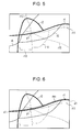
- Fig. 5 is a diagram illustrating the types of roads of the embodiment of the present invention.
- Fig. 6 is a diagram for explaining the driving route setting method of the embodiment of the present invention.
- Fig. 7 is a diagram illustrating an example of a matching target road map of the embodiment of the present invention.
- r1, r2, r5, r6, and r11 to r15 indicate roads, and p1 indicates a branch point at which the road 11 branches from the road r1.
- the respective roads are classified into types in accordance with the attributes of the roads and recorded in the data recording unit 16 ( Fig. 1 ). That is, the respective roads are classified into the first to tenth types.
- the first type includes the intercity expressways of the expressways.
- the second type includes the toll roads such as the urban expressways of the expressways.
- the third type includes the one-digit national highways of the national highways.
- the fourth type includes the two-digit national highways of the national highways.
- the fifth type includes the remaining highways of the national highways.
- the sixth type includes the major highways of the prefectural highways.
- the seventh type includes the remaining highways of the prefectural highways.
- the eighth type includes the major roads of the local roads.
- the ninth type includes the remaining roads of the local roads.
- the tenth type includes the narrow streets.
- the respective roads which are classified into the first to tenth types in accordance with the attributes of the roads in this case, can also be classified into the first to tenth types in the order of the traffic amount from the largest or in the order of the road distance from the start point to the end point from the longest.
- the roads r1 and r2 are included in the one-digit national highways of the national highways, and belong to the third type. Further, the roads r5 and r6 are included in the major highways of the prefectural highways, and belong to the sixth type. Further, the roads r11 to r15 are included in the remaining roads of the local roads, and belong to the ninth type.
- not-illustrated mode determination processing means of the CPU 31 performs a mode determination process to determine whether or not the touch mode has been selected as the specified mode. If the touch mode has been selected, not-illustrated driving route setting processing means of the CPU 31 performs a driving route setting process to set a road traced with a finger on the map screen as the driving route to the destination.
- the matching target roads are changed in accordance with the scale of the map displayed on the map screen.
- scale determination processing means of the driving route setting processing means performs a scale determination process to read the scale of the map displayed on the map screen at the time of the process.
- the map screen is formed thereon with a plurality of scale change switches prepared for respective scales.
- the switches constitute a scale change unit for changing the scale of the displayed map.
- the scale determination processing means can read the scale of the map displayed on the map screen.
- the scale of the map is expressed in the size of the area shown by the map on the map screen.
- the map is classified into, for example, a street map, a 50 m map, a 100 m map, a 200 m map, a 400 m map, an 800 m map, a 1.6 km map, a 3 km map, a 7 km map, a 13 km map, a 26 km map, a 50 km map, a 100 km map, and so forth in the order of the area size from the smallest.
- matching target road selection processing means of the driving route setting processing means performs a matching target road selection process to select the matching target roads corresponding to the scale of the map by referring to the matching target road map of Fig. 7 recorded in the data recording unit 16.
- the intercity expressways are included in the matching target roads.
- the toll roads, the one-digit national highways, and the two-digit national highways are included in the matching target roads, and if the 400 m map, the 800 m map, or the 1.6 km map is displayed, the toll roads, the remaining highways of the national highways, and the major highways of the prefectural highways are included in the matching target roads.
- the toll roads, the remaining highways of the national highways, the remaining highways of the prefectural highways, and the major roads of the local roads are included in the matching target roads
- the 50 m map is displayed, the toll roads, the remaining highways of the national highways, the remaining highways of the prefectural highways, and the remaining roads of the local roads are included in the matching target roads.
- the street map is displayed, all roads including the narrow streets are included in the matching target roads.
- the roads not included in the matching target roads are excluded from the targets used for setting the driving route.
- specification determination processing means of the driving route setting processing means performs a specification determination process to determine whether or not a road on the map screen has been specified through the touch on the road by the driver, i.e., whether or not the tracing with a finger has been performed along a road on the map screen in the present embodiment.
- road selection processing means of the driving route setting processing means performs a road selection process to select, from the matching target roads corresponding to the read scale, i.e., the matching target roads corresponding to the map displayed on the map screen, the road nearest to a point touched by the driver, i.e., the road nearest to the tracing track in the present embodiment, as the road used for setting the driving route.
- the driver performs the tracing along a road on the map screen.
- the road nearest to the specified point can be selected as the road used for setting the driving route.
- the road nearest to the track drawn by the plurality of specified points can be selected as the road used for setting the driving route.
- the road selection processing means selects from the one-digit national highways r1 and r2 the road r1 for setting the driving route.
- the road r11 is included in the remaining roads of the local roads, and thus is not included in the matching target roads in the 3 km map. Therefore, the road r11 does not constitute the road for setting the driving route.
- driving route display processing means of the driving route setting processing means performs a driving route display process to display the driving route Rt1 on the map along the road r1.
- route confirmation processing means of the driving route setting processing means performs a route confirmation process to confirm the driving route Rt1 displayed on the map screen.
- the driving route can be set in the above-described manner.
- the road selection processing means selects from the matching target roads another road adjacent to the already selected road as a candidate for the driving route Rt1, for example. Then, the driving route display processing means displays the driving route on the map along the another road.
- the tracing does not need to be performed throughout from the tracing start point s1 to the tracing end point e1 along the road, and may be performed only along a segment of the road from the tracing start point s1 to the tracing end point e1.
- the matching target roads are selected in accordance with the scale of the map displayed on the map screen, and the road used for setting the driving route is selected from the selected matching target roads. Therefore, when a plurality of roads are located adjacent to one another, for example, it is possible to prevent a road different from the road intended by the driver from being set as the driving route. Accordingly, a predetermined road on the map screen can be accurately set as the driving route.
- Step S1 the touch mode is selected.
- Step S2 the scale is read.
- Step S3 the matching target road selection process is performed.
- Step S4 the tracing is waited for. If the tracing has been performed, the procedure moves to Step S5.
- Step S5 a road is selected.
- Step S6 the driving route is displayed.
- Step S7 whether or not the tracing has been performed is determined. If the tracing has been performed, the procedure moves to Step S8. If the tracing has not been performed, the procedure is completed.
- Step S8 another road is selected.
- Step S9 the driving route is displayed, and the processing is completed.
- the driving route is set by the tracing with a finger along a road on the map screen. If the driver wants to change at least a part of the route searched for in the route search process, and if the driver traces a predetermined section, a predetermined road can be selected and set as the driving route.
- the touch panel is used as the display unit 35, and the touching movement is performed along a predetermined road on the map screen.
- a liquid crystal screen or the like can be used as the display unit 35, and the driving route can be set by the movement of a cursor along a predetermined road on the map screen.
- the driving route is set in the navigation device 14.
- the driving route can be set through the operation of a personal computer.
- the present invention enables accurate setting of a predetermined road as a driving route.
- the present invention includes scale determination processing means for reading the scale of a map displayed on a map screen, matching target road selection processing means for selecting, in accordance with the scale of the map, matching target roads which are target roads used for setting a driving route, specification determination processing means for determining whether or not a road has been specified by an operator, and road selection processing means for selecting, if the road has been specified by the operator, one of the matching target roads nearest to a specified point as a road used for setting the driving route. If the road has been specified, one of the matching target roads nearest to the specified point is selected. Therefore, the driving route can be accurately set.
Landscapes
- Engineering & Computer Science (AREA)
- Radar, Positioning & Navigation (AREA)
- Remote Sensing (AREA)
- Automation & Control Theory (AREA)
- Physics & Mathematics (AREA)
- General Physics & Mathematics (AREA)
- Navigation (AREA)
- Instructional Devices (AREA)
- Traffic Control Systems (AREA)
Applications Claiming Priority (1)
| Application Number | Priority Date | Filing Date | Title |
|---|---|---|---|
| JP2007144754A JP2008298573A (ja) | 2007-05-31 | 2007-05-31 | 経路設定システム、経路設定方法及びそのプログラム |
Publications (1)
| Publication Number | Publication Date |
|---|---|
| EP1998143A2 true EP1998143A2 (de) | 2008-12-03 |
Family
ID=39720358
Family Applications (1)
| Application Number | Title | Priority Date | Filing Date |
|---|---|---|---|
| EP08156645A Withdrawn EP1998143A2 (de) | 2007-05-31 | 2008-05-21 | System und Verfahren zur Routeneinstellung sowie Programm zur Ausführung des Verfahrens |
Country Status (4)
| Country | Link |
|---|---|
| US (1) | US20080300781A1 (de) |
| EP (1) | EP1998143A2 (de) |
| JP (1) | JP2008298573A (de) |
| CN (1) | CN101315282A (de) |
Cited By (1)
| Publication number | Priority date | Publication date | Assignee | Title |
|---|---|---|---|---|
| CN110793523A (zh) * | 2019-08-22 | 2020-02-14 | 腾讯科技(深圳)有限公司 | 引导路线匹配方法、装置、计算机设备及存储介质 |
Families Citing this family (5)
| Publication number | Priority date | Publication date | Assignee | Title |
|---|---|---|---|---|
| WO2006078049A1 (ja) * | 2005-01-19 | 2006-07-27 | Kabushiki Kaisha Kenwood | 案内経路生成装置および案内経路生成方法 |
| JP5852920B2 (ja) | 2012-05-17 | 2016-02-03 | クラリオン株式会社 | ナビゲーション装置 |
| CN103471606B (zh) * | 2013-08-27 | 2016-08-10 | 深圳市凯立德科技股份有限公司 | 导航方法及导航设备 |
| KR101776739B1 (ko) | 2016-04-29 | 2017-09-08 | 현대자동차 주식회사 | 내비게이션 및 이의 교통 정보 매칭 방법 |
| US10378918B2 (en) * | 2017-01-03 | 2019-08-13 | Microsoft Technology Licensing, Llc | Generating routes from lines based on zoom levels |
Citations (2)
| Publication number | Priority date | Publication date | Assignee | Title |
|---|---|---|---|---|
| JP2000111354A (ja) | 1998-10-07 | 2000-04-18 | Denso Corp | 経路設定装置及びナビゲーション装置 |
| JP2007144754A (ja) | 2005-11-28 | 2007-06-14 | Daicel Chem Ind Ltd | インク記録体用樹脂組成物及びインク記録体 |
-
2007
- 2007-05-31 JP JP2007144754A patent/JP2008298573A/ja active Pending
-
2008
- 2008-05-21 EP EP08156645A patent/EP1998143A2/de not_active Withdrawn
- 2008-05-23 CN CNA2008101091623A patent/CN101315282A/zh active Pending
- 2008-05-23 US US12/153,729 patent/US20080300781A1/en not_active Abandoned
Patent Citations (2)
| Publication number | Priority date | Publication date | Assignee | Title |
|---|---|---|---|---|
| JP2000111354A (ja) | 1998-10-07 | 2000-04-18 | Denso Corp | 経路設定装置及びナビゲーション装置 |
| JP2007144754A (ja) | 2005-11-28 | 2007-06-14 | Daicel Chem Ind Ltd | インク記録体用樹脂組成物及びインク記録体 |
Cited By (2)
| Publication number | Priority date | Publication date | Assignee | Title |
|---|---|---|---|---|
| CN110793523A (zh) * | 2019-08-22 | 2020-02-14 | 腾讯科技(深圳)有限公司 | 引导路线匹配方法、装置、计算机设备及存储介质 |
| CN110793523B (zh) * | 2019-08-22 | 2022-06-10 | 腾讯科技(深圳)有限公司 | 引导路线匹配方法、装置、计算机设备及存储介质 |
Also Published As
| Publication number | Publication date |
|---|---|
| JP2008298573A (ja) | 2008-12-11 |
| CN101315282A (zh) | 2008-12-03 |
| US20080300781A1 (en) | 2008-12-04 |
Similar Documents
| Publication | Publication Date | Title |
|---|---|---|
| EP2280242B1 (de) | Karteninformationsführungsvorrichtung, Karteninformationsführungsverfahren und Computerprogramm | |
| EP2306155B1 (de) | Navigationsvorrichtung mit Multitouch-Icon-Selektion | |
| EP2120226A2 (de) | Gereiste-Verbindung Identifizierungssystem | |
| EP2236986A2 (de) | Navigationsvorrichtung mit spezifischen Kartenbildschirmrollen und Zielorteinstellung | |
| CN108225347B (zh) | 通信终端、移动引导系统以及移动引导方法 | |
| US20040111215A1 (en) | Navigation system | |
| JP2004239864A (ja) | ナビゲーション装置並びに該装置用プログラム及び記録媒体 | |
| CN108885116B (zh) | 通信终端、服务器装置、移动引导系统以及计算机程序 | |
| EP1312893A2 (de) | Navigationsvorrichtung | |
| EP1936519A1 (de) | System zur generierung von umgebungssuchdaten, umgebungssuchsystem, verfahren zur generierung von umgebungssuchdaten, umgebungssuchverfahren und navigationsgerät | |
| US20080300781A1 (en) | Route setting system, route setting method, and program for executing the method | |
| JPWO2006001414A1 (ja) | 交通状況表示装置、その方法、そのプログラム、および、そのプログラムを記録した記録媒体 | |
| EP2103907A2 (de) | Bildschirmbildungssystem, Bildschirmbildungsverfahren und -programm | |
| JP4394426B2 (ja) | ナビゲーション装置及び履歴情報表示方法 | |
| JP2012133245A (ja) | 地図表示装置、地図表示方法及びコンピュータプログラム | |
| EP2261822A1 (de) | Punktsuchvorrichtung, Punktsuchverfahren und Computerprogrammprodukt | |
| JP2017078775A (ja) | 地図情報更新システム、地図情報更新方法及びコンピュータプログラム | |
| KR20060051008A (ko) | 내비게이션 장치, 정보 입출력 장치, 내비게이션 시스템,내비게이션 방법의 프로그램 및 정보 입출력 방법의프로그램 | |
| JP3978309B2 (ja) | ナビゲーション装置、番地表示方法及びそのプログラムを記録した記録媒体 | |
| JP2011033402A (ja) | 渋滞度案内装置、渋滞度案内方法及びコンピュータプログラム | |
| JP3753045B2 (ja) | ナビゲーションシステム及び経路探索方法のプログラム | |
| JP3783487B2 (ja) | 情報検索装置 | |
| JP3948401B2 (ja) | ナビゲーションシステム及びナビゲーション装置 | |
| JP3780861B2 (ja) | ナビゲーション装置及び道路案内方法のプログラム | |
| JP3864638B2 (ja) | 情報検索装置 |
Legal Events
| Date | Code | Title | Description |
|---|---|---|---|
| PUAI | Public reference made under article 153(3) epc to a published international application that has entered the european phase |
Free format text: ORIGINAL CODE: 0009012 |
|
| AK | Designated contracting states |
Kind code of ref document: A2 Designated state(s): AT BE BG CH CY CZ DE DK EE ES FI FR GB GR HR HU IE IS IT LI LT LU LV MC MT NL NO PL PT RO SE SI SK TR |
|
| AX | Request for extension of the european patent |
Extension state: AL BA MK RS |
|
| STAA | Information on the status of an ep patent application or granted ep patent |
Free format text: STATUS: THE APPLICATION HAS BEEN WITHDRAWN |
|
| 18W | Application withdrawn |
Effective date: 20091002 |