EP1717559A2 - Dispositif déstiné à la navigation d'un véhicule et système de serveur - Google Patents
Dispositif déstiné à la navigation d'un véhicule et système de serveur Download PDFInfo
- Publication number
- EP1717559A2 EP1717559A2 EP06111007A EP06111007A EP1717559A2 EP 1717559 A2 EP1717559 A2 EP 1717559A2 EP 06111007 A EP06111007 A EP 06111007A EP 06111007 A EP06111007 A EP 06111007A EP 1717559 A2 EP1717559 A2 EP 1717559A2
- Authority
- EP
- European Patent Office
- Prior art keywords
- address
- representation
- unit
- designed
- server system
- Prior art date
- Legal status (The legal status is an assumption and is not a legal conclusion. Google has not performed a legal analysis and makes no representation as to the accuracy of the status listed.)
- Withdrawn
Links
- 238000013519 translation Methods 0.000 claims abstract description 35
- 238000001514 detection method Methods 0.000 claims description 2
- 238000000034 method Methods 0.000 description 19
- 238000013461 design Methods 0.000 description 3
- 238000012545 processing Methods 0.000 description 3
- 230000005540 biological transmission Effects 0.000 description 2
- 238000010586 diagram Methods 0.000 description 2
- 230000015572 biosynthetic process Effects 0.000 description 1
- 230000001427 coherent effect Effects 0.000 description 1
- 238000010276 construction Methods 0.000 description 1
- 238000012937 correction Methods 0.000 description 1
- 238000011161 development Methods 0.000 description 1
- 230000018109 developmental process Effects 0.000 description 1
- 208000001848 dysentery Diseases 0.000 description 1
- 230000006870 function Effects 0.000 description 1
- 230000003287 optical effect Effects 0.000 description 1
Images


Classifications
-
- G—PHYSICS
- G08—SIGNALLING
- G08G—TRAFFIC CONTROL SYSTEMS
- G08G1/00—Traffic control systems for road vehicles
- G08G1/09—Arrangements for giving variable traffic instructions
- G08G1/0962—Arrangements for giving variable traffic instructions having an indicator mounted inside the vehicle, e.g. giving voice messages
- G08G1/0968—Systems involving transmission of navigation instructions to the vehicle
- G08G1/096877—Systems involving transmission of navigation instructions to the vehicle where the input to the navigation device is provided by a suitable I/O arrangement
- G08G1/096883—Systems involving transmission of navigation instructions to the vehicle where the input to the navigation device is provided by a suitable I/O arrangement where input information is obtained using a mobile device, e.g. a mobile phone, a PDA
-
- G—PHYSICS
- G01—MEASURING; TESTING
- G01C—MEASURING DISTANCES, LEVELS OR BEARINGS; SURVEYING; NAVIGATION; GYROSCOPIC INSTRUMENTS; PHOTOGRAMMETRY OR VIDEOGRAMMETRY
- G01C21/00—Navigation; Navigational instruments not provided for in groups G01C1/00 - G01C19/00
- G01C21/26—Navigation; Navigational instruments not provided for in groups G01C1/00 - G01C19/00 specially adapted for navigation in a road network
- G01C21/34—Route searching; Route guidance
- G01C21/36—Input/output arrangements for on-board computers
- G01C21/3605—Destination input or retrieval
- G01C21/3608—Destination input or retrieval using speech input, e.g. using speech recognition
-
- G—PHYSICS
- G01—MEASURING; TESTING
- G01C—MEASURING DISTANCES, LEVELS OR BEARINGS; SURVEYING; NAVIGATION; GYROSCOPIC INSTRUMENTS; PHOTOGRAMMETRY OR VIDEOGRAMMETRY
- G01C21/00—Navigation; Navigational instruments not provided for in groups G01C1/00 - G01C19/00
- G01C21/26—Navigation; Navigational instruments not provided for in groups G01C1/00 - G01C19/00 specially adapted for navigation in a road network
- G01C21/34—Route searching; Route guidance
- G01C21/36—Input/output arrangements for on-board computers
- G01C21/3605—Destination input or retrieval
- G01C21/3623—Destination input or retrieval using a camera or code reader, e.g. for optical or magnetic codes
Definitions
- the invention relates to a device which is designed to navigate a vehicle to a predefinable destination, and to a server system.
- Devices for navigating a vehicle require a user of the device to separately enter address components that together uniquely identify a geographic location.
- the address components are e.g. a place name or a street name. After entering the first letters the user is offered a selection list with matching to the entered letters address components from which this can select the respectively desired, unique address component.
- the address components together form a target for navigation. However, such separate input of the address components is time consuming.
- the object of the invention is to provide a device and a server system for navigating a vehicle, in which or in which a destination is easily predetermined.
- the invention is characterized by a device which is designed to navigate a vehicle to a predefinable destination.
- the device is designed such that the predefinable destination can be predetermined by means of a first address representation of a geographical location.
- the device comprises at least one interface unit, on the input side, the first address representation can be supplied.
- the device comprises at least one address recognition unit that is configured, a second address representation from the first address representation.
- the apparatus further comprises an address translation unit configured to translate the second address representation into a geographic coordinate representation.
- the device further comprises a navigation unit, which is designed to perform a route guidance to the predetermined destination, depending on the geographical coordinate representation.
- the invention is based on the recognition that users of the device for navigating the vehicle usually have a large number of addresses that represent a potential destination for navigation.
- these addresses are in different representations or at different locations, e.g. in a mobile phone, in a personal digital assistant, on a business card, as a notebook entry, as a map of a city map or as a photograph of the geographical location.
- Such representations of addresses form the first address representation that designate or represent a geographic location.
- the navigation is based on a mathematical reference system, which is formed by a coordinate system.
- the first address representation is therefore translated into the geographic coordinate representation that uniquely predetermines a location of the geographic location with respect to the coordinate system.
- the route guidance to the predetermined destination can be made by optical or acoustic signals or by a graphical presentation of route information or a map excerpt or by other appropriate means to inform a driver of the vehicle hints or driving instructions that allow the driver, depending on these the way to find the given goal.
- the route guidance may also include determining an appropriate route to the given destination, eg from a current location.
- the advantage is that it is very easy to specify the destination by supplying the first address representation.
- the user can already use existing addresses or address representations to specify the destination without having to reenter the respective address or its address components.
- the first address representation can be supplied by means of different media.
- the geographical location may be represented by the first address representation in different ways, e.g. as a spoken address, as a written address or as a photograph of the geographical location.
- Each address recognition unit is designed, for example, to determine the second address representation from the first address representation in each case for one type of representation of the geographical location.
- the invention is characterized by a device which is designed to navigate a vehicle to a predefinable destination.
- the device is designed such that the predefinable destination can be predetermined by means of a first address representation of a geographical location.
- the device comprises at least one interface unit, on the input side, the first address representation can be supplied.
- the device comprises at least one address recognition unit which is designed to determine a second address representation from the first address representation.
- the apparatus further comprises a first transceiver unit configured to send the second address representation to a server system and to receive therefrom a geographical coordinate representation of the geographical location or a route to the predetermined destination or corresponding driving instructions.
- the device further comprises a navigation unit, which is formed, depending on the geographical coordinate representation, the route or the driving instructions to perform a route guidance to the specified destination.
- the advantage is that it is very easy to specify the destination by supplying the first address representation.
- the user can already use existing addresses or address representations to specify the destination without having to reenter the respective address or its address components.
- the first address representation can be supplied by means of different media.
- the geographical location may be represented by the first address representation in different ways, e.g. as a spoken address, as a written address or as a photograph of the geographical location.
- Each address recognition unit is designed, for example, to determine the second address representation from the first address representation in each case for one type of representation of the geographical location.
- Driving instructions may include instructions to the driver of the vehicle that enable the driver to drive the vehicle to the predetermined destination. Driving instructions, however, may also include control or positioning signals that enable automatic control of the vehicle to the predetermined destination.
- the first address representation is a spoken address.
- the at least one address recognition unit is designed for recognition of language. The advantage is that the device by the address of the address, the first address representation is very easy to feed.
- the first address representation is an image of a written address.
- the at least one address recognition unit is designed to recognize writing.
- the first address representation is an image of the geographical location.
- the at least one address recognition unit is designed to recognize the geographical location represented in the image.
- the invention is characterized by a device which is designed to navigate a vehicle to a predefinable destination.
- the device is designed such that the predefinable destination can be predetermined by means of a first address representation of a geographical location.
- the device comprises at least one interface unit, on the input side, the first address representation can be supplied.
- the apparatus includes a first transceiver configured to send the first address representation to a server system and receive a second address representation therefrom.
- the apparatus further comprises an address translation unit configured to translate the second address representation into a geographic coordinate representation.
- the device further comprises a navigation unit, which is designed depending on the geographic coordinate representation to perform a guidance to the given destination.
- the advantage is that it is very easy to specify the destination by supplying the first address representation.
- the user can already use existing addresses or address representations to specify the destination without having to reenter the respective address or its address components.
- the first address representation can be supplied by means of different media.
- a further advantage is that the device can be of simple design since recognition of an address in the first address representation can be performed by the server system.
- the at least one address recognition unit or the address translation unit is designed to determine address components of the first or the second address representation and to detect and / or correct errors of the address components.
- Address components are, for example, a place name, a street name or else a name of a subway stop or a hotel or the name of a trade fair.
- the at least one address recognition unit or the address translation unit is designed to check for uniqueness the address components and for providing at least one selection list of similar, each unique address components from which a desired address component for the user is selectable if the respective address component is not unique.
- the advantage is that the user only has to select if an address component, especially in connection with other address components, is ambiguous. As a result, the effort to pretend the device, the goal is low.
- the invention is characterized by a device which is designed to navigate a vehicle to a predefinable destination.
- the device is designed such that the predefinable destination can be predetermined by means of a first address representation of a geographical location.
- the device comprises at least one interface unit, on the input side, the first address representation can be supplied.
- the apparatus comprises a first transceiver unit configured to send the first address representation to a server system and to receive therefrom a geographical coordinate representation of the geographical location or a route to the predetermined destination or corresponding driving instructions.
- the device further comprises a navigation unit, which is designed to perform a route guidance to the predetermined destination, depending on the geographical coordinate representation, the route or the driving instructions.
- the advantage is that it is very easy to specify the destination by supplying the first address representation.
- the user can already use existing addresses or address representations to specify the destination without having to reenter the respective address or its address components.
- the first address representation can be supplied by means of different media.
- a further advantage is that the device can be particularly simple in design, since the recognition of the address in the first address representation and the translation into the geographical coordinate representation and, if appropriate, the determination of the route or the driving instructions can be carried out by the server system.
- the first address representation and / or the second address representation is a text.
- a text in particular an alphanumeric text, allows a very simple representation and further processing of the address.
- address recognition units are known which recognize speech or writing and convert it into a text.
- VCARD discloses a text-based data format that is suitable for representing addresses and forming the first or the second address representation.
- the device comprises at least one internal database or the device can be coupled to at least one external database.
- the device is designed to determine the second address representation and / or the geographical coordinate representation by means of queries to the at least one internal database and / or to the at least one external database.
- the advantage is that the geographic coordinate representation of a very large number of possible addresses can be determined.
- the databases, in particular the external database can be simply expandable or updatable, so that the geographical coordinate representation can also be determined, for example, for new addresses which, for example, were not yet available at the time the device was manufactured.
- the internal database may also be an electronic address book in which the user can store geographic locations of importance to the user.
- the device comprises a position determination unit for determining a current position.
- the current position can be stored as coordinate representation in the internal database and / or in the external database together with an address or a description of the associated geographical location.
- This has the advantage that the user can individually store geographical locations or specify as the target for navigation, even if the respective geographical location at the current position has not yet been assigned an address which is stored in the internal or in the external database.
- the internal database, in particular the address book, and possibly the external database are so easily expandable.
- the invention is characterized by a server system comprising a second transceiver unit, at least one address recognition unit and an address translation unit.
- the second transceiver unit is configured to receive a first address representation.
- the at least one address recognition unit is designed to determine a second address representation from the first address representation.
- the address translation unit is designed to translate the second address representation into a geographical coordinate representation or to determine a route to the specified destination or corresponding driving instructions.
- the server system is configured to transmit the geographical coordinate representation, the route or the driving instructions via the second transceiver unit.
- the server system can very easily be allocated more resources than the device for navigating the vehicle.
- the server system can be designed as a central unit and can be configured such that the server system can be used independently of one another for a plurality of devices and optionally simultaneously usable.
- the server system can be easily expandable or updateable or comprise at least one database or can be coupled to at least one database in order to take into account current information, eg traffic or route information or current events such as trade fairs, concerts or events sporting events.
- the invention is characterized by a server system which comprises a second transceiver unit and at least one address identification unit.
- the second transceiver unit is configured to receive a first address representation.
- the at least one address recognition unit is designed to determine a second address representation from the first address representation.
- the server system is configured to send the second address representation via the second transceiver unit.
- the server system can very easily be allocated more resources than the device for navigating the vehicle.
- the server system can be embodied as a central unit and configured such that the server system can be used independently of one another and optionally simultaneously for a plurality of devices.
- the server system can be easily expandable or updatable, or can comprise at least one database or can be coupled to at least one database.
- the first address representation is a spoken address and the at least one address recognition unit is designed to recognize speech.
- the spoken address is very easily transferable to the server system, eg as an audio file or as an audio data stream.
- the first address representation is an image of a written address and the at least one address recognition unit is designed to recognize writing.
- the image is very easily transferable to the server system, e.g. as an image file.
- the first address representation is an image of a geographical location and the at least one address recognition unit is designed to recognize the geographical location represented in the image.
- the at least one address recognition unit or the address translation unit is designed to determine address components of the first or the second address representation and to detect and / or correct errors of the address components.
- the at least one address recognition unit or the address translation unit is designed to check for unambiguousness of the address components and to provide at least one selection list of similar, respectively unique address components from which a desired address component can be selected for a user, if the respective one address component is not unique.
- the advantage is that the user only has to select the suitable device if an address component, in particular also in connection with further address components, is ambiguous.
- the at least one selection list can simply be made available to the user via the second transceiver unit on the device. As a result, the effort to pretend the device, the goal is low.
- the first address representation and / or the second address representation is a text.
- a text in particular an alphanumeric text, allows a very simple representation and further processing of the address.
- address recognition units are known which recognize speech or writing and convert it into a text.
- VCARD discloses a text-based data format that is suitable for representing addresses and forming the first or the second address representation.
- a device for navigating a vehicle which is preferably arranged in the vehicle, comprises an interface unit IU, an address translation unit ATrans and a navigation unit Nav (FIG. 1).
- the address translation unit ATrans is coupled on the input side to the interface unit IU and is coupled on the output side to the navigation unit Nav.
- the device comprises a first address recognition unit ARec1, a second address recognition unit ARec2, a third address recognition unit ARec3 and a fourth address recognition unit ARec4.
- a first address recognition unit ARec1, a second address recognition unit ARec2, a third address recognition unit ARec3 and a fourth address recognition unit ARec4 are coupled on the input side to the interface unit IU and are coupled on the output side to the address translation unit ATrans.
- an electronic address book AB and a user interface UI are provided.
- the address book AB is coupled to the interface unit IU, the address translation unit ATrans and to the user interface UI.
- the device may also include a telephone unit Phone which is coupled to the address book AB and the user interface UI.
- the navigation unit Nav is further coupled to a position determination unit GPS, which is designed to determine a current position of the vehicle.
- the device also has an internal database iDB, which is connected to the address translation unit ATrans, the navigation unit Nav and optionally coupled to the fourth address detection unit ARec4.
- the address translation unit ATrans and possibly also the navigation unit Nav or the fourth address recognition unit ARec4 can be coupled to an external database eDB. It is also possible to provide several internal databases iDB and / or external databases eDB.
- the address book AB can also be designed as an internal database iDB or as an external database eDB.
- the interface unit IU can be supplied with a first address representation.
- the first address representation designates a geographical location, e.g. is given as a city, as a street and / or as a building.
- the first address representation is preferably a compact digital representation of the geographic location or an address associated with the geographic location, e.g. in the form of a file or a data stream.
- "Compact" in this context means that e.g. the address in the first address representation is contiguously represented and thus can be supplied to the interface unit IU in a coherent manner.
- known devices for navigating a vehicle require a separate supply of address components, such as e.g. a street name or place name that a user of the device must manually enter or select.
- the first address representation can be supplied to the interface unit IU eg as an image or as a text.
- the first address representation can be supplied to the interface unit IU, for example, by means of wireless data transmission, for example by means of Bluetooth, infrared or wireless local area network, or wired data transmission, for example by means of Universal Serial Bus, for example from a mobile telephone or from a personal digital assistant, also known as PDA, or by means of storage media, such as compact disks, digital versatile disks or flash memory media.
- the interface unit IU can also be coupled eg with a microphone and an analog / digital converter.
- the first address representation may then be, for example, a spoken address that can be spoken by the user into the microphone.
- the address translation unit ATrans is designed to determine a geographical coordinate representation of the geographical location from the first address representation, provided that it is in an appropriate form.
- the geographic coordinate representation is suitable as a target for the navigation unit Nav.
- the navigation unit Nav is designed to determine a suitable route from the current position to the destination and the user of the device via the user interface UI driving instructions, depending on the current position of the vehicle and the destination to grant that allow the user to steer the vehicle to the destination.
- the geographic coordinate representation may be based on a geographic, on an eclipse, or on some other coordinate system.
- the geographic coordinate representation is formed by, for example, a WGS84 coordinate.
- the navigation unit Nav can also be configured to have the route determined by a server system and to issue corresponding driving instructions to the user or to have the driving system determine the driving instructions and to appropriately communicate these to the user via the user interface UI.
- the device then preferably comprises a transceiver unit for communicating with the server system.
- the device can also be coupled via the transceiver unit with the external database eDB.
- the transceiver unit may also be e.g. be formed by the telephone unit Phone.
- the first address representation is for example a text, in particular an alphanumeric text, with a predetermined one Structure that corresponds, for example, to a virtual business card.
- a text-based, virtual business card is known as VCARD, for example.
- the first address representation can also be structured differently.
- the address translation unit ATrans can determine address components from the first address representation. Address components are, for example, a place name, a street name, or even a name of a company.
- the first address representation may also include other address components, such as a name of a metro stop, a hotel name, a restaurant name, a name of a fair or a name of a person who may be assigned eg a place of residence or work.
- the address translation unit ATrans determines the associated geographical coordinate representation from the determined address components.
- the internal database iDB and / or the external database eDB and also the address book AB can be used.
- the first address representation is the spoken address, then this is preferably supplied to the first address recognition unit ARec1, which is designed to recognize speech and preferably to convert it into text and to recognize address components.
- the first address representation is an image, eg of a digitized business card, then the image is fed to the second address recognition unit ARec2, which is designed to recognize writing and preferably to convert it into text and to recognize address components.
- a handwritten notated address can be supplied in digitized form to the third address recognition unit ARec3, which is designed to recognize the handwriting and to convert it into text and to recognize address components.
- the second address recognition unit ARec2 and the third address recognition unit ARec3 are preferably designed to recognize address fields, for example letters or business cards.
- the first address representation may also be a photograph of the geographical location, e.g. from a building or a place.
- the photo is preferably supplied to the fourth address recognition unit ARec4.
- the fourth address recognition unit ARec4 is designed to recognize the geographical location shown in the photo and to determine the address associated with this geographical location. For this purpose, a request to the internal database iDB and / or to the external database eDB may be required. However, it may also be e.g. a place of residence of a person depicted in the photo or another geographical location associated with that person.
- the first address recognition unit ARec1, the second address recognition unit ARec2, the third address recognition unit A-Rec3 and the fourth address recognition unit ARec4 are designed to convert the first address representation into a second address representation, which is preferably an alphanumeric text.
- the second address representation is supplied to the address translation unit ATrans.
- the address translation unit ATrans determines according to the first address representation from the second address representation, the associated geographical coordinate representation.
- the fourth address recognition unit ARec4 can also be configured such that, depending on a data format of the first address representation, a suitable address recognition algorithm is loaded and then executed, eg from the internal database iDB or the external database eDB. This has the advantage that simply a large number of data formats can be supported. If necessary, only a few address recognition units or even only the fourth address recognition unit ARec4 may then be provided in the device. The device is very easily expandable in order to support further address recognition algorithms or data formats.
- FIG. 2 shows a further device which comprises a first transceiver unit TR1, which is coupled on the input side to the interface unit IU and which is coupled on the output side to the navigation unit Nav.
- the first transceiver unit TR1 may also comprise the telephone unit Phone or the telephone unit Phone may also be in the form of or comprise the first transceiver unit TR1.
- the first address recognition unit ARec1, the second address recognition unit ARec2, the third address recognition unit A-Rec3 and the fourth address recognition unit ARec4 and the address translation unit ATrans are outsourced to the server system (FIG. 3). Furthermore, the at least one internal database iDB can also be swapped out to the server system. Furthermore, the server system can be coupled to the at least one external database eDB.
- the server system has a second transceiver unit TR2.
- the server system is preferably designed such that more than one device can communicate with the server system, in particular independently of one another and simultaneously.
- the server system may also comprise more than one transceiver TR2, which may be distributed to different locations.
- the first transceiver unit TR1 and the second transceiver unit TR2 can preferably be coupled to one another via a radio link.
- the server system may also be e.g. to the Internet or to another network, e.g. be coupled to a telephone network or a mobile network.
- the device is preferably designed such that the first address representation is sent via the first transceiver unit TR1 to the second transceiver unit TR2.
- the server system determines the geographical coordinate representation from the first address representation. the route to the predetermined destination or appropriate driving instructions to steer the vehicle to the predetermined destination.
- the geographical coordinate representation, the route or the driving instructions can then be sent by means of the second transceiver TR2 to the first transceiver TR1 and be supplied in the device, for example, the navigation unit Nav.
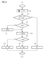
- FIG. 4 shows a flowchart of a method performed by the device.
- the method starts in a step S1.
- a step S2 the first address representation of the device, in particular the interface unit IU, supplied.
- a step S3 it is checked whether the first address representation is present in a permissible data format, ie in a data format that can be processed by the address translation unit ATrans or one of the address recognition units. If this condition is fulfilled, then the method is continued in a step S4. However, if the condition is not fulfilled, an error message is output by means of the user interface UI in a step S5 and the method is ended in a step S11.
- step S4 it is checked whether the first address representation is an alphanumeric text. Is the condition is satisfied, then in step S6 the first address representation in the address translation unit ATrans is translated into the associated geographic coordinate representation. However, if the first address representation in step S4 is not an alphanumeric text, then the first address representation is supplied to at least one of the address recognition units in a step S7. The recognized and translated into the alphanumeric text address is then supplied in step S6 as the second address representation of the address translation unit ATrans.
- step S8 it is checked whether the geographical coordinate representation is to be used as the target in the navigation unit Nav. If this condition is fulfilled, then the geographical coordinate representation of the navigation unit Nav is supplied in a step S9. Otherwise, however, the geographic coordinate representation may also be stored in the address book AB in a step S10. The process ends in step S11.
- FIG. 5 shows a second flow diagram of a method for determining and processing address components of the first or the second address representation.
- the process starts in a step S20.
- the alphanumeric text read by the first address representation e.g. is given by the text-based virtual business card, or by the second address representation.
- a step S22 it is checked whether the address is in a structured text format, eg as VCARD. If this condition is satisfied, then the method is continued in a step S23. However, if the condition is not met, then in step S24, typical identifiers of address components are searched. Such typical identifiers are, for example, street, town, postal code or postal code. In a step S25 it is checked whether such identifiers have been found. If this condition is fulfilled, then in one Step S26 recognizes the address components based on the identifier. The method may then proceed to step S23.
- a structured text format eg as VCARD.
- step S27 searches are made for typical location or street names or digit sequences, for example postal codes or house numbers.
- typical endings of place names or abbreviations are eg "Str" for "street” and "P1" for "square".
- step S28 it is then checked whether typical place or street names, digit sequences or abbreviations could be determined. If this condition is fulfilled, then the address components can be determined in step S26. However, if the condition is not satisfied, an error message is generated in a step S29 and the method is ended in a step S33.
- step S23 the address components are checked for errors, for example typical typographical or spelling errors or recognition errors. Detected errors will be corrected automatically if necessary.
- step S30 typical abbreviations are resolved, eg "Str" replaced by "street”.
- step S31 it is then checked whether all the address components which are required for determining the geographic coordinate representation are given. For example, a street name alone usually does not suffice to determine the geographical coordinate representation. However, the street name in combination with the place name or the street name in combination with the postal code may constitute a translatable address. If there is a translatable address, then this is provided in a step S32 for the address translation in the geographical coordinate representation and the process is terminated in step S33. However, it is not translatable Address before, then in step S29, the error message is generated and the process in step S33 ends.
- Figure 6 shows a flow diagram of a method for translating the address into the geographic coordinate representation of the geographic location.
- the method begins in a step S40, which preferably follows the step S32.
- an address component e.g. the place name
- a step S42 it is checked if the address component has been found. If this condition is fulfilled, then the method is continued in a step S43. However, if the condition is not fulfilled, the error message is generated in a step S44 and the method is ended in a step S49.
- step S43 it is checked whether the respective address component is unique. For example, several places may exist that have the same place name, eg Frankfurt, so either Frankfurt an der Oder or Frankfurt am Main, or weather, so either weather on the Ruhr or weather in the district of Marburg. However, the respective address component can also be ambiguous by a spelling error which could not be automatically corrected. If the address component is unique, then the method is continued in a step S45. However, if the address component is not unique, then in a step S46 the user is provided with a selection list from which the desired unique address component can be selected. In the selection list, preferably only the unique address components are listed which have a high correspondence with the ambiguous address component. The method then continues in step S45.
- the address component is unique. For example, several places may exist that have the same place name, eg Frankfurt, so either Frankfurt an der Oder or Frankfurt am Main, or weather, so either weather on the Ruhr or weather in the district of Marburg. However, the respective address component can also be ambiguous by a spelling
- uniqueness of address components can also be produced by having a plurality of address components, eg the place name and the postal code or the street name and the place name, with each other be linked.
- the street name exists only for one of the possible locations.
- step S45 it is checked whether additional address components are present or required in order to be able to unambiguously determine the geographical coordinate representation, e.g. the house number, which can be particularly useful on long roads. If this condition is fulfilled, then a further address component is selected in a step S47 and reconciled with the database in step S41. Otherwise, the geographical coordinate representation is determined in a step S48 and the process is ended in step S49.
- additional address components e.g. the house number
- the determined geographical coordinate representation can be stored together with the first or the second address representation or with the corrected and unique address components in the internal database iDB, in particular in the address book AB, or in the external database eDB, so that the first address representation only once in the coordinate representation must be translated and the geographic coordinate representation available for later use. It is also possible to supply the corrected and unique address components, for example to the mobile telephone or the personal digital assistant, in order to replace faulty address components there.
- the first address representation can in particular also represent places of special interest, so-called points of interest. For example, from an entry in a diary, eg "Frankfurt Book Fair” or “Frankfurt Book Fair", the unique geographic coordinate representation can be ascertained by means of a database query without having to provide complete details of the location, street, zip code and house number.
- This simplification can also be used, for example, for a hotel, a restaurant, the metro station or to specify a company building as a navigation destination. In particular, depending on the current position of the vehicle, for example, the nearest hotel or restaurant can be specified as a navigation destination. The user only has to intervene if information is incomplete and not resolvable or ambiguous.
- geographic coordinate representations can also be determined for which there is no information in the internal database iDB or for the existing information in the internal database iDB are obsolete.
- search engines that are interrogated over the Internet for example, can be used for fairs, hotels, restaurants or other points of interest or for other geographical locations, each of which can determine the geographical coordinate representation of the sought geographical location.
- the internal database iDB and / or the external database eDB can be made expandable.
- the current position which is determined by means of the position determining unit GPS, can be provided with address components if desired and stored in the internal database iDB, in the external database eDB or in the address book AB.
- the recognition of address fields and address components, the replacement of abbreviations and, if necessary, the correction of spelling errors and the formation of combinations of address components, which together form the translatable address, are preferably country-specific and language-specific, since the address format or the spelling of e.g. Place names can be different.
Applications Claiming Priority (1)
| Application Number | Priority Date | Filing Date | Title |
|---|---|---|---|
| DE102005019591A DE102005019591A1 (de) | 2005-04-27 | 2005-04-27 | Vorrichtung zum Navigieren eines Fahrzeugs und Server-System |
Publications (2)
| Publication Number | Publication Date |
|---|---|
| EP1717559A2 true EP1717559A2 (fr) | 2006-11-02 |
| EP1717559A3 EP1717559A3 (fr) | 2008-07-16 |
Family
ID=36699331
Family Applications (1)
| Application Number | Title | Priority Date | Filing Date |
|---|---|---|---|
| EP06111007A Withdrawn EP1717559A3 (fr) | 2005-04-27 | 2006-03-13 | Dispositif déstiné à la navigation d'un véhicule et système de serveur |
Country Status (3)
| Country | Link |
|---|---|
| US (1) | US20060248224A1 (fr) |
| EP (1) | EP1717559A3 (fr) |
| DE (1) | DE102005019591A1 (fr) |
Cited By (3)
| Publication number | Priority date | Publication date | Assignee | Title |
|---|---|---|---|---|
| EP1901036A2 (fr) * | 2006-09-18 | 2008-03-19 | VDO Automotive AG | Système de navigation pour un véhicule |
| EP2101153A1 (fr) * | 2008-03-14 | 2009-09-16 | Alcatel Lucent | Guidage sur un terminal mobile à partir d'objets filmés ou photographiés |
| DE102009045040B4 (de) | 2009-09-25 | 2021-09-30 | Robert Bosch Gmbh | Navigationssystem |
Families Citing this family (11)
| Publication number | Priority date | Publication date | Assignee | Title |
|---|---|---|---|---|
| TWI296106B (en) * | 2005-07-04 | 2008-04-21 | Mitac Int Corp | Method for auto writing in contact list |
| DE102007014868A1 (de) * | 2007-03-14 | 2008-09-18 | Richard Beyer | Verfahren und Vorrichtung zum Auffinden von Adressen |
| US8340897B2 (en) * | 2007-07-31 | 2012-12-25 | Hewlett-Packard Development Company, L.P. | Providing contemporaneous maps to a user at a non-GPS enabled mobile device |
| US20090089319A1 (en) * | 2007-10-01 | 2009-04-02 | Tele Atlas North America, Inc. | System and Method for Differentiating Duplicate Addresses in a Locality |
| US8401780B2 (en) * | 2008-01-17 | 2013-03-19 | Navteq B.V. | Method of prioritizing similar names of locations for use by a navigation system |
| US20090271106A1 (en) * | 2008-04-23 | 2009-10-29 | Volkswagen Of America, Inc. | Navigation configuration for a motor vehicle, motor vehicle having a navigation system, and method for determining a route |
| US20090271200A1 (en) * | 2008-04-23 | 2009-10-29 | Volkswagen Group Of America, Inc. | Speech recognition assembly for acoustically controlling a function of a motor vehicle |
| KR101662595B1 (ko) * | 2009-11-03 | 2016-10-06 | 삼성전자주식회사 | 사용자 단말 장치, 경로 안내 시스템 및 그 경로 안내 방법 |
| US9105029B2 (en) * | 2011-09-19 | 2015-08-11 | Ebay Inc. | Search system utilizing purchase history |
| KR101813532B1 (ko) * | 2015-11-06 | 2017-12-29 | 현대자동차주식회사 | 통신 모듈, 그를 가지는 차량 및 그 제어 방법 |
| DE102018212484A1 (de) * | 2018-07-26 | 2020-01-30 | Audi Ag | Verfahren zum Festlegen eines Navigationsziels in einem Navigationssystem sowie Kraftfahrzeug |
Citations (1)
| Publication number | Priority date | Publication date | Assignee | Title |
|---|---|---|---|---|
| US20040267443A1 (en) * | 2003-05-02 | 2004-12-30 | Takayuki Watanabe | Navigation system and method therefor |
Family Cites Families (14)
| Publication number | Priority date | Publication date | Assignee | Title |
|---|---|---|---|---|
| JP3468824B2 (ja) * | 1994-03-29 | 2003-11-17 | 本田技研工業株式会社 | 車両誘導装置 |
| HU210899B (en) * | 1994-07-08 | 1996-02-28 | Szabo | Universal input card especially for gps apparatuses and gps apparatus operating with said card |
| JP2907079B2 (ja) * | 1995-10-16 | 1999-06-21 | ソニー株式会社 | ナビゲーション装置,ナビゲート方法及び自動車 |
| US7327711B2 (en) * | 1996-09-05 | 2008-02-05 | Symbol Technologies, Inc. | System for digital radio communication between a wireless LAN and a PBX |
| DE19927647A1 (de) * | 1999-06-17 | 2000-12-21 | Grundig Ag | Fahrzeugnavigationssystem |
| US6615131B1 (en) * | 1999-12-21 | 2003-09-02 | Televigation, Inc. | Method and system for an efficient operating environment in a real-time navigation system |
| JP2001289661A (ja) * | 2000-04-07 | 2001-10-19 | Alpine Electronics Inc | ナビゲーション装置 |
| US6490521B2 (en) * | 2000-12-28 | 2002-12-03 | Intel Corporation | Voice-controlled navigation device utilizing wireless data transmission for obtaining maps and real-time overlay information |
| DE10149862A1 (de) * | 2001-10-10 | 2003-05-08 | Daimler Chrysler Ag | Verfahren und Vorrichtung zur Zielauswahl eines Navigationssystems in einem Kraftfahrzeug unter Verwendung einer Dienstezentrale |
| TW535959U (en) * | 2002-02-27 | 2003-06-01 | C One Technology Corp | GPS electronic peripheral card capable of dynamically inserting/removing navigation information |
| JP2005038103A (ja) * | 2003-07-17 | 2005-02-10 | Ntt Docomo Inc | 案内装置、案内システム、及び案内方法 |
| JP4231507B2 (ja) * | 2003-12-18 | 2009-03-04 | パナソニック株式会社 | ナビゲーションシステム、携帯情報端末装置、サーバ、およびナビゲーション方法 |
| US7289039B2 (en) * | 2004-09-10 | 2007-10-30 | Xanavi Informatics Corporation | Apparatus and method for processing and displaying traffic information in an automotive navigation system |
| US7373248B2 (en) * | 2004-09-10 | 2008-05-13 | Atx Group, Inc. | Systems and methods for off-board voice-automated vehicle navigation |
-
2005
- 2005-04-27 DE DE102005019591A patent/DE102005019591A1/de not_active Ceased
-
2006
- 2006-03-13 EP EP06111007A patent/EP1717559A3/fr not_active Withdrawn
- 2006-04-26 US US11/412,150 patent/US20060248224A1/en not_active Abandoned
Patent Citations (1)
| Publication number | Priority date | Publication date | Assignee | Title |
|---|---|---|---|---|
| US20040267443A1 (en) * | 2003-05-02 | 2004-12-30 | Takayuki Watanabe | Navigation system and method therefor |
Cited By (5)
| Publication number | Priority date | Publication date | Assignee | Title |
|---|---|---|---|---|
| EP1901036A2 (fr) * | 2006-09-18 | 2008-03-19 | VDO Automotive AG | Système de navigation pour un véhicule |
| EP1901036A3 (fr) * | 2006-09-18 | 2010-10-13 | Continental Automotive GmbH | Système de navigation pour un véhicule |
| EP2101153A1 (fr) * | 2008-03-14 | 2009-09-16 | Alcatel Lucent | Guidage sur un terminal mobile à partir d'objets filmés ou photographiés |
| FR2928804A1 (fr) * | 2008-03-14 | 2009-09-18 | Alcatel Lucent Sas | Guidage sur un terminal mobile a partir d'objets filmes ou photographies. |
| DE102009045040B4 (de) | 2009-09-25 | 2021-09-30 | Robert Bosch Gmbh | Navigationssystem |
Also Published As
| Publication number | Publication date |
|---|---|
| EP1717559A3 (fr) | 2008-07-16 |
| DE102005019591A1 (de) | 2006-11-09 |
| US20060248224A1 (en) | 2006-11-02 |
Similar Documents
| Publication | Publication Date | Title |
|---|---|---|
| EP1717559A2 (fr) | Dispositif déstiné à la navigation d'un véhicule et système de serveur | |
| DE69933422T2 (de) | System und Verfahren zur Routenführung mit einem Navigationsanwendungsprogram | |
| EP1176395B1 (fr) | Dans un système de navigation, méthode de sélection de la designation d'un lieu via un interface vocal | |
| EP0905662B1 (fr) | Système d'introduction de données pour au moins les noms de localités et de rues | |
| DE19934190C2 (de) | Bildanzeigevorrichtung für ein Navigationssystem, Verfahren zur Anzeige eines Bildes und Speichermedium mit Programm zur Durchführung des Verfahrens | |
| EP1269119B1 (fr) | Procede pour entrer une destination dans un appareil de navigation | |
| DE60038269T2 (de) | Punktssuchausgabesystem mittels einer Telefonnummer und Speichermedium | |
| DE102004025599A1 (de) | Auffinden von Karteninformationen | |
| EP1360458B1 (fr) | Procede d'echange d'informations de navigation | |
| DE10359283A1 (de) | Navigationssystem und Programm sowie Speichermedium zur Verwendung desselben | |
| DE112007000069T5 (de) | Bordinformationsendgerät und Karteninformations-Bereitstellungsvorrichtung und Karteninformations-Bereitstellungssystem, das dieselben verwendet | |
| DE102008015987B4 (de) | Navigationsvorrichtung und Verfahren zur Straßennamenssuche | |
| EP2313742B1 (fr) | Procédé et dispositif pour fournir des données de navigation, appareil de navigation | |
| DE102005017484A1 (de) | Adress-Datenbank und Adress-Auffindungssystem unter Verwendung dieser | |
| DE102009045040B4 (de) | Navigationssystem | |
| DE112017008047T5 (de) | Karteninformationsverwaltungsvorrichtung, Karteninformationsverwaltungssystem und Karteninformationsverwaltungsverfahren | |
| DE102015205044A1 (de) | Eingabe von Navigationszieldaten in ein Navigationssystem | |
| EP2100097B1 (fr) | Dispositif de navigation | |
| DE102007016887B3 (de) | Verfahren und Vorrichtung zum Betreiben eines Navigationssystems | |
| EP2019290A2 (fr) | Procédé de saisie d'objectif sur un appareil de navigation et appareil de navigation | |
| EP1693815B1 (fr) | Procédé pour procurer des entrées dans un dispositif d'information d'un conducteur | |
| DE10125825B4 (de) | Verfahren zur Spracheingabe und Datenträger | |
| DE102012014484A1 (de) | Unterstützen eines Fahrers eines Kraftfahrzeugs durch ein Übersetzen von Verkehrszeichen | |
| DE102018010101A1 (de) | Bestimmen eines Navigationsziels mittels einer Navigationseinrichtung | |
| DE102005006365A1 (de) | Hilfsverfahren zum Festlegen von Fahrzeug-Satelliten-Navigations-Fahrzielen |
Legal Events
| Date | Code | Title | Description |
|---|---|---|---|
| PUAI | Public reference made under article 153(3) epc to a published international application that has entered the european phase |
Free format text: ORIGINAL CODE: 0009012 |
|
| AK | Designated contracting states |
Kind code of ref document: A2 Designated state(s): AT BE BG CH CY CZ DE DK EE ES FI FR GB GR HU IE IS IT LI LT LU LV MC NL PL PT RO SE SI SK TR |
|
| AX | Request for extension of the european patent |
Extension state: AL BA HR MK YU |
|
| RAP1 | Party data changed (applicant data changed or rights of an application transferred) |
Owner name: CONTINENTAL AUTOMOTIVE GMBH |
|
| PUAL | Search report despatched |
Free format text: ORIGINAL CODE: 0009013 |
|
| AK | Designated contracting states |
Kind code of ref document: A3 Designated state(s): AT BE BG CH CY CZ DE DK EE ES FI FR GB GR HU IE IS IT LI LT LU LV MC NL PL PT RO SE SI SK TR |
|
| AX | Request for extension of the european patent |
Extension state: AL BA HR MK YU |
|
| RIC1 | Information provided on ipc code assigned before grant |
Ipc: G08G 1/0968 20060101ALI20080610BHEP Ipc: G01C 21/36 20060101AFI20060804BHEP |
|
| 17P | Request for examination filed |
Effective date: 20090116 |
|
| AKX | Designation fees paid |
Designated state(s): DE FR GB IT |
|
| 17Q | First examination report despatched |
Effective date: 20090312 |
|
| STAA | Information on the status of an ep patent application or granted ep patent |
Free format text: STATUS: THE APPLICATION IS DEEMED TO BE WITHDRAWN |
|
| 18D | Application deemed to be withdrawn |
Effective date: 20110329 |