EP1519152A1 - Vorrichtung und Verfahren zur Darstellung von Fahrhinweisen - Google Patents
Vorrichtung und Verfahren zur Darstellung von Fahrhinweisen Download PDFInfo
- Publication number
- EP1519152A1 EP1519152A1 EP04020752A EP04020752A EP1519152A1 EP 1519152 A1 EP1519152 A1 EP 1519152A1 EP 04020752 A EP04020752 A EP 04020752A EP 04020752 A EP04020752 A EP 04020752A EP 1519152 A1 EP1519152 A1 EP 1519152A1
- Authority
- EP
- European Patent Office
- Prior art keywords
- reliability
- vehicle
- navigation
- environment
- navigation instructions
- Prior art date
- Legal status (The legal status is an assumption and is not a legal conclusion. Google has not performed a legal analysis and makes no representation as to the accuracy of the status listed.)
- Granted
Links
- 238000000034 method Methods 0.000 title claims description 17
- 238000012937 correction Methods 0.000 claims abstract description 16
- 230000007613 environmental effect Effects 0.000 claims description 8
- 230000001419 dependent effect Effects 0.000 claims description 5
- 238000004891 communication Methods 0.000 claims description 4
- 238000001514 detection method Methods 0.000 claims description 3
- 239000011521 glass Substances 0.000 claims description 3
- 230000001133 acceleration Effects 0.000 claims description 2
- 238000003384 imaging method Methods 0.000 description 4
- 230000000694 effects Effects 0.000 description 3
- 238000003909 pattern recognition Methods 0.000 description 3
- 230000033228 biological regulation Effects 0.000 description 2
- 238000011156 evaluation Methods 0.000 description 2
- 238000005259 measurement Methods 0.000 description 2
- 238000004364 calculation method Methods 0.000 description 1
- 238000005352 clarification Methods 0.000 description 1
- 230000000295 complement effect Effects 0.000 description 1
- 238000010276 construction Methods 0.000 description 1
- 230000007423 decrease Effects 0.000 description 1
- 238000004519 manufacturing process Methods 0.000 description 1
- 239000003550 marker Substances 0.000 description 1
- 230000004297 night vision Effects 0.000 description 1
- 230000003287 optical effect Effects 0.000 description 1
- 238000012545 processing Methods 0.000 description 1
- 238000004904 shortening Methods 0.000 description 1
- 230000001629 suppression Effects 0.000 description 1
- 230000000007 visual effect Effects 0.000 description 1
Images
Classifications
-
- G—PHYSICS
- G01—MEASURING; TESTING
- G01C—MEASURING DISTANCES, LEVELS OR BEARINGS; SURVEYING; NAVIGATION; GYROSCOPIC INSTRUMENTS; PHOTOGRAMMETRY OR VIDEOGRAMMETRY
- G01C21/00—Navigation; Navigational instruments not provided for in groups G01C1/00 - G01C19/00
- G01C21/26—Navigation; Navigational instruments not provided for in groups G01C1/00 - G01C19/00 specially adapted for navigation in a road network
- G01C21/34—Route searching; Route guidance
- G01C21/36—Input/output arrangements for on-board computers
- G01C21/3626—Details of the output of route guidance instructions
- G01C21/365—Guidance using head up displays or projectors, e.g. virtual vehicles or arrows projected on the windscreen or on the road itself
-
- G—PHYSICS
- G01—MEASURING; TESTING
- G01C—MEASURING DISTANCES, LEVELS OR BEARINGS; SURVEYING; NAVIGATION; GYROSCOPIC INSTRUMENTS; PHOTOGRAMMETRY OR VIDEOGRAMMETRY
- G01C21/00—Navigation; Navigational instruments not provided for in groups G01C1/00 - G01C19/00
- G01C21/26—Navigation; Navigational instruments not provided for in groups G01C1/00 - G01C19/00 specially adapted for navigation in a road network
- G01C21/28—Navigation; Navigational instruments not provided for in groups G01C1/00 - G01C19/00 specially adapted for navigation in a road network with correlation of data from several navigational instruments
-
- G—PHYSICS
- G01—MEASURING; TESTING
- G01C—MEASURING DISTANCES, LEVELS OR BEARINGS; SURVEYING; NAVIGATION; GYROSCOPIC INSTRUMENTS; PHOTOGRAMMETRY OR VIDEOGRAMMETRY
- G01C21/00—Navigation; Navigational instruments not provided for in groups G01C1/00 - G01C19/00
- G01C21/26—Navigation; Navigational instruments not provided for in groups G01C1/00 - G01C19/00 specially adapted for navigation in a road network
- G01C21/34—Route searching; Route guidance
- G01C21/36—Input/output arrangements for on-board computers
- G01C21/3626—Details of the output of route guidance instructions
- G01C21/3632—Guidance using simplified or iconic instructions, e.g. using arrows
Definitions
- the invention relates to a device and a method for Representation of driving instructions for vehicle navigation in one Picture of the vehicle environment.
- DE 101 38 719 A1 discloses a method and a device for displaying driving instructions in the vehicle, which determined by a navigation system driving instructions projected onto the windshield or into one of a picture of the environment captured by a video camera, which is shown on the display of the navigation system becomes.
- the driving instructions are in the form of virtual2-1n trains or arrows from the perspective of the driver or the camera the way to be hit on the windshield or on the display in accordance with the front of the vehicle Mark road, shown.
- the orientation of the displayed Navigation instructions in the image of the vehicle environment is doing according to the satellite-based position determination of the navigation system.
- the display of branches also at uphill and downhill from the perspective of Driver or the camera are correct is from the GPS position data of the vehicle - possibly supported by dead reckoning - and the location of the vehicle with the help of a 3D terrain model a corresponding shortening or extension of the lines.
- a positioning for the vehicle with the help of a satellite-based Systems delivers because of inevitable mistakes Position information with different deviation from the real position of the vehicle.
- Such deviations can may be reduced by dead reckoning, but with larger ones Errors concerning the position determination - for example through reflections or in areas where the reception the satellite signals are disturbed - are larger deviations unavoidable, so that environmental driving advice not exactly enough in line with the environment can be brought. That is, the driver on the Projection screen displayed virtual marked road appears, for example, next to the actual roadway offset; Under certain circumstances, even the roadway with marked oncoming traffic, or the image jumps back and forth. This is necessarily irritating for the driver and draws his attention from the actual traffic from.
- Be navigation instructions in a picture of the vehicle environment (this can be a video image on a display or a head-up display in connection with the windscreen), for example represented in the form of lines or arrows, the align themselves on the road, or as markings, the refer to prominent points of the vehicle environment, shown, It is important that these notes with as possible continuous precision in the image of the vehicle environment be fitted.
- WO 03 005 102 A1 describes a head-up display system and a method for one - in terms of the view of one Vehicle occupants correct - Marking objects in the vehicle environment.
- the location-correct or location-related representation taken from the perspective of a vehicle occupant on its detected by sensors head or eye position.
- the objects to be marked essentially relate to other road users or traffic signs.
- the to be marked Objects of the vehicle environment are thereby using Cameras and pattern recognition identified and for marking modeled on the windshield suitable. It is also thought of a visual implementation of navigation data, in which case the road to be traveled or a junction is marked for the driver's view on the head-up display.
- the object of the invention is an apparatus and a method with an always reliably interpretable representation of navigation hints in a picture of the driving environment to accomplish.
- the inventive method makes the representation of the Navigation system determined navigation instructions of the reliability that determined by a satellite-based system Position indication for the vehicle dependent.
- the image generation unit generates the navigation hint determined by the navigation system So always in a form of representation, according to the reliability achievable for the position indication for the driver is best recorded and the least distraction brings with it.
- a navigation or driving advice may be provided by the imaging unit for example, with highly accurate position information comfortable for the driver as virtual, the road creates the following lines and precise in a picture of Vehicle environment displayed on a projection screen in the vehicle become. Is the reliability of the position information for a satisfactory presentation of driving instructions with direct reference to the environment but too low, switches convert the image generation unit to other forms of representation, for example, on schematic arrows or virtual traffic signs, from which the driver does not expect them optically adapt to the changing environment. schematically or abstract navigation information displayed on a fixed space on the screen or A reference of the driving instruction to the environment is strongly damped tracked. The more abstract forms of representation Significance lost in comparison to representations relating to the environment the hint shown, for example, by supporting acoustic hints are compensated.
- the determination of reliability for those by the satellite System determined position information is advantageous through a collection and evaluation of the statistical Values which satellite systems usually to indicate the accuracy of the determined position. These Values are used by the navigation system when determining the position with, and from this to the device for the determination Reliability passed.
- the reliability itself can be used as a statistical measure in various sizes, for example as a standard deviation or an error probability be expressed.
- the position indication is advantageous by correction data of a Ground station specified, while also the reliability corrected with values for the reliability of this specification becomes.
- the device for determining the Position indication the data for correcting the position by the navigation system, which this data and also the data on the reliability of this position correction from the ground station receives, and the data to correct the reliability to the device for determining reliability transmitted.
- the correction of the reliability determination can also be the amount of correction to the position was improved. Receives this difference the navigation system of the device for the determination the position information.
- position corrections as for satellite Navigation systems by receiving signals from permanently measured Ground stations, for example, by differential GPS are possible, the accuracy of the position information advantageous to be improved by several meters. This helps in Areas where the reception of such stations possible is the position of a vehicle with a high reliability to determine. In such areas, the inventive System object - related navigation instructions on the Projection surface in sufficient accordance with the Represent objects of the vehicle environment.
- the position information for the vehicle can be further improved by comparing the determined position with a digital map becomes (lane-matching). Also such a position adjustment in turn leads to increased reliability for the position indication, whereby the improvement becomes greater, the more accurate the digital map is.
- the Reliability accordingly with values for the reliability this clarification is corrected.
- These are the vehicle-mounted sensors with the device for determination the position information connected by the sensors the data to correct the position information receives.
- the device for determining the reliability receives from the vehicle sensors Data for the corresponding correction of reliability. These data relate to the reliability of the sensors or their measurements.
- the advantage of position corrections with the help of the vehicle Sensors consists mainly in that hereby a disturbed Reception of the necessary for the position determination Satellite signals can be bridged or compensated.
- the satellite signals can be high and dense Buildings reflected or in forests by dense foliage be shaded in places, leaving the position for a presentation of driving instructions related to the real Environment are no longer sufficient can be determined exactly.
- Multipath effects can for example, by a second antenna for the reception of Satellite position data on the vehicle, with the largest possible Distance to the first antenna, by difference calculations Getting corrected.
- a particularly advantageous possibility for relative precision the position indication consists in the employment of a video-supported Lane detection, the result of which is a correction of the Position indication in lateral direction allowed. With night vision devices This is reliably possible even at night.
- a Precision of the position information in the lateral direction is just for a presentation of navigation hints as virtual Road markings of particular importance to it the virtual marker will not accidentally be an adjacent one Lane or even the opposite lane displays.
- the data that these position correction sensors provide Data on the reliability of the measurements can be determined.
- manufacturer information about the sensors be, time- or distance-dependent weighted sizes or, in the case of the video-based recognition system, values for the recognition security.
- the image generation unit generates the navigation instructions accordingly at a high Reliability in an environmental representation, at a low reliability in a symbolic representation and at a medium reliability - depending on navigation note to be displayed - either in environment-related or symbolic representation.
- a three-stage distinction of forms of representation for Navigation instructions carries the requirement of one for the driver distraction-free presentation of the navigation instructions sufficient bill.
- schematized Arrows can also be virtual signposts or Traffic signs are displayed.
- the reliability of Height information is essentially only of interest if sufficiently accurate maps are also available for altitude information. Otherwise, the vertical dimension does not need to be evaluated or a relatively rough classification is sufficient for occasional matches.
- Switching between the different forms of representation takes place only when the reliability for a certain period of time in the appropriate reliability range lies.
- the period for adherence to a high Reliability for switching to the environment-related To be on the safe side, the presentation should be made longer than the period for medium or low reliability for switching to a symbolic representation of the navigation instructions.
- the navigation instructions advantageous in the correct position for the driver or view to the perspective of a camera on suitable objects in the picture projected in the vehicle environment.
- the correct position of the environment-related navigation hints is doing in the case of the combination of display and camera advantageous by determining the relative position the camera to the environment using the existing inertial sensor guaranteed.
- the camera together with the position information of the inertial sensor and the map information associated with the navigation hint can be the image generation unit the right place for a virtual marker of objects of the vehicle environment necessary for the navigation instructions be marked, determine and on the projection screen projecting correctly in the image.
- a correct representation of the environmental navigation information by means of a head-up display or by means of a semi-transparent data glasses will be advantageous accordingly the statements made on the display by determination of position and position of the driver's head relative to the environment achieved by means of a head-tracking system.
- objects of the vehicle environment are as correctly positioned as possible at a specific viewing angle - be that of the camera or the driver - virtually marked by means of a projection screen. So objects are not only road courses in question, it is also conceivable to align the navigation of buildings or to give advice on distinctive points or special points of interest (POI). The latter, for example, can be connoted with interesting information for the passenger in particular.
- POI point or special points of interest
- the optical reference to these objects also takes place in a representation that takes into account the reliability of the position determination.
- Further navigation instructions relate, for example, to construction sites, Accidents, detours or traffic jams.
- This information be like the rest of the environment information, the digital Card taken, which regularly via a communication link to a service center for this information is updated and supplemented.
- navigation instructions For the most accurate interpretation of navigation instructions is it useful to provide certain information, which has the navigation system, not to indicate to the driver not to distract or confuse. These include, for example Routes that are not visible to the driver such as curves or tunnels or underpasses. Therefore, it is advantageous if the imaging system Navigation instructions that are on - from the perspective of the driver or the camera - refer to hidden objects, not - or distinctively different, as navigation hints are based on Obtain visible objects. This can be ensured advantageous when the image forming unit from the navigation system Information to the distinction objects obscured from the perspective of the driver or the camera are, of objects that are visible, receives.
- the hidden or non-visible objects can then either completely excluded from the presentation, or For example, they can be dashed or paler Shading will be displayed. It can be next to the information also the digital map also more information about Suppression of hidden objects are used.
- a Distronic sensor can, for example, the distance to a be calculated ahead of the vehicle, so that a virtual Road marking then, for example, only up to this Vehicle is displayed.
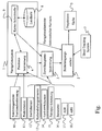
- the figure shows a preferred embodiment with a Navigation system 1 for receiving position data from a satellite-based system 10, which from the device 4 to Position determination of the navigation system are processed. Together with the position data, the navigation system receives 1 Data on the accuracy of this position data. These Data is taken from the navigation system for further processing to the device 3 for determining the reliability passed the position determination.
- the navigation device 1 receives continue to correct the positioning data, the processed by the device 4 for position determination and data on the reliability of this correction, the the navigation system to the device 3 for determining the Reliability transmitted.
- the inertial sensor 12, the steering angle sensor 14, the wheel revolution sensors 13 - together with the anti-slip regulation 17 and the anti-lock braking system 18, the lane recognition 15 and the barometer 16 provide the means 4 for positioning Signals for further correction of the position information.
- the same sensors and system supply the device 3 for determining the reliability of their reliability respective contributions to the item correction that make up the Device 3 sets a new value for the reliability of Position information calculated.
- the device 4 for position determination sends the position information to the card interface 9, the soahnd the digital map 8 performs a position matching (lane matching).
- the card interface 9 gives the corrected Position indication to the device 4 for position determination returns and sends a value for the correction of reliability to the device 3 for determining the reliability.
- the map interface from the digital map 8 according to the desired Destination continues to have a navigation hint and all necessary for a pictorial representation of the navigation reference Information and environmental information provided via a Interface of the navigation system as so-called electronic Horizon output to the image forming unit 2 become.
- the image generation unit 2 generates from the navigation notice and the electronic horizon pictorial representations of the navigation note, which points it to a projection screen 5 projected.
- Position information distinguishes the imaging unit 2 between environment-related and symbolic forms of representation.
- the environment-related representations mark thereby the perceptible on the projection surface 5 objects virtual, where it matters, the ones on the screen Vehicle-visible markings from view of the observer with the objects outside.
- This form of presentation is therefore according to the invention only for used very reliable position information, since this is the Match the real position of the vehicle with the fictitious one Position on the digital map is crucial.
- the symbolic form of presentation with low reliability the position determination is limited to fixed representations of clues on the projection screen.
- the symbolic representations Objects are assigned to the environment loosely.
- the projection screen can be, for example, a windshield be in which the navigation instructions on a Head-Up Display are mirrored.
- a head tracking system 7 which is the Image generation unit 2 Information on the position and position of the driver's head supplies.
Landscapes
- Engineering & Computer Science (AREA)
- Radar, Positioning & Navigation (AREA)
- Remote Sensing (AREA)
- Automation & Control Theory (AREA)
- Physics & Mathematics (AREA)
- General Physics & Mathematics (AREA)
- Navigation (AREA)
Abstract
Description
- ein Display sein, auf dem das durch eine Kamera aufgenommene Bild der Fahrzeugumgebung wiedergegeben wird, in welches die durch die Bilderzeugungseinheit erzeugten Darstellungen der Navigationshinweise eingeblendet werden, oder
- eine halbdurchlässige Datenbrille oder
- die Windschutzscheibe in Verbindung mit einem Head-Up-Display sein, in welche die durch die Bilderzeugungseinheit erzeugten Navigationshinweise einblendbar sind.
Claims (19)
- Verfahren zur Darstellung von Navigationshinweisen auf einer Projektionsfläche (5) in einem Fahrzeug, umfassend ein Navigationssystem (1), welches mittels eines satellitengestützten Systems (10) fortlaufend Positionsangaben für das Fahrzeug ermittelt, und welches mittels einer Bilderzeugungseinheit (2) die vom Navigationssystem (1) ermittelten Navigationshinweise erzeugt und in einem Bild der Fahrzeugumgebung auf der Projektionsfläche (5) darstellt,
dadurch gekennzeichnet, dass eine Zuverlässigkeit für die Positionsangabe ermittelt wird, und die Bilderzeugungseinheit (2) die Navigationshinweise zuverlässigkeitsabhängig in unterschiedlicher Darstellung erzeugt. - Verfahren gemäß Anspruch 1,
dadurch gekennzeichnet, dass die Zuverlässigkeit aus statistischen Werten, die das satellitengestützte System (10) zur Genauigkeit der ermittelten Position angibt, bestimmt wird. - Verfahren gemäß einem der Ansprüche 1 oder 2,
dadurch gekennzeichnet, dass die Positionsangabe durch Korrekturdaten einer Bodenstation (11) präzisiert wird, und die Zuverlässigkeit mit Werten für die Zuverlässigkeit dieser Präzisierungen korrigiert wird. - Verfahren gemäß einem der Ansprüche 1 bis 3,
dadurch gekennzeichnet, dass die Positionsangabe durch fahrzeugseitig erhobene Signale präzisiert wird, und die Zuverlässigkeit mit Werten für die Zuverlässigkeit dieser Präzisierungen korrigiert wird. - Verfahren gemäß Anspruch 4,
dadurch gekennzeichnet, dass als fahrzeugseitig erhobene Signale Beschleunigung und/oder eine relative Höhenänderung und/oder das Resultat einer Fahrspurerkennung verwendet werden. - Verfahren gemäß einem der Ansprüche 1 bis 5,
dadurch gekennzeichnet, dass die Bilderzeugungseinheit (2) die zuverlässigkeitsabhängige Darstellung der Navigationshinweiseerzeugt.bei einer hohen Zuverlässigkeit umgebungsbezogen,bei einer geringen Zuverlässigkeit symbolisch undbei einer mittleren Zuverlässigkeit in Abhängigkeit vom darzustellenden Navigationshinweis entweder umgebungsbezogen oder symbolisch - Verfahren gemäß Anspruch 6,
dadurch gekennzeichnet, dass bei der umgebungsbezogenen Darstellung die Navigationshinweise lagerichtig zur Sicht des Fahrers oder zum Blickwinkel einer Kamera (6) auf geeignete Objekte im Bild der Fahrzeugumgebung projiziert werden. - Verfahren gemäß einem der Ansprüche 6 oder 7,
dadurch gekennzeichnet, dass Navigationshinweise, die sich auf - aus Sicht des Fahrers oder der Kamera (6) - verdeckte Objekte beziehen, nicht - oder unterscheidbar anders, als Navigationshinweise, die sich auf sichtbare Objekte beziehen - dargestellt werden. - Vorrichtung zur Darstellung von Navigationshinweisen auf einer Projektionsfläche (5) in einem Fahrzeug, umfassend ein Navigationssystem (1) zur fortlaufenden Ermittlung einer Positionsangabe für das Fahrzeug mittels eines satellitengestützten Systems (10) und einer Bilderzeugungseinheit (2) zur Erzeugung der vom Navigationssystem ermittelten Navigationshinweise und Darstellung in einem Bild der Fahrzeugumgebung auf der Projektionsfläche (5),
dadurch gekennzeichnet, dass eine Einrichtung zur Bestimmung der Zuverlässigkeit der Positionsangabe (3) vorhanden ist, die mit der Bilderzeugungseinheit (2) zur zuverlässigkeitsabhängigen Erzeugung unterschiedlicher Darstellungen für die Navigationshinweise verbunden ist. - Vorrichtung gemäß Anspruch 9,
dadurch gekennzeichnet, dass die Einrichtung zur Bestimmung der Zuverlässigkeit (3) über das Navigationssystem mit dem satellitengestützten System (10) zum Empfang von Daten, die Genauigkeit der Positionsangabe betreffend, in Kommunikationsverbindung steht. - Vorrichtung gemäß einem der Ansprüche 9 oder 10,
dadurch gekennzeichnet, dass eine Bodenstation (11) mit der Einrichtung zur Ermittlung der Positionsangabe (4) zum Empfang von Daten zur Korrektur der Positionsangabe und über das Navigationssystem mit der Einrichtung zur Bestimmung der Zuverlässigkeit (3) zum Empfang von Daten zur Korrektur der Zuverlässigkeit in Kommunikationsverbindung steht. - Vorrichtung gemäß einem der Ansprüche 9 bis 11,
dadurch gekennzeichnet, dass fahrzeugseitige Sensoren mit der Einrichtung zur Ermittlung der Positionsangabe (4) zum Empfang von Daten zur Korrektur der Positionsangabe und mit der Einrichtung zur Bestimmung der Zuverlässigkeit (3) zum Empfang von Daten zur Korrektur der Zuverlässigkeit in Kommunikationsverbindung stehen. - Vorrichtung gemäß Anspruch 12,
dadurch gekennzeichnet, dass als fahrzeugseitige Sensoren ein Inertialsensor (12) und/oder Radumdrehungssensoren (13) in Kombination mit einem Lenkwinkelsensor (14) und/oder ein Barometer (16) und/oder eine video-gestützte Fahrspurerkennung (15) vorgesehen sind. - Vorrichtung gemäß einem der Ansprüche 9 bis 13,
dadurch gekennzeichnet, dass die Darstellung der mittels der Bilderzeugungseinrichtung (2) erzeugten Navigationshinweise zuverlässigkeitsabhängigist.bei einer hohen Zuverlässigkeit umgebungsbezogen,bei einer geringen Zuverlässigkeit symbolisch undbei einer mittleren Zuverlässigkeit in Abhängigkeit vom darzustellenden Navigationshinweis entweder umgebungsbezogen oder symbolisch - Vorrichtung gemäß einem der Ansprüche 9 bis 14,
dadurch gekennzeichnet, dass die Projektionsfläche (5) ein Display ist, auf dem das durch eine Kamera (6) aufgenommene Bild der Fahrzeugumgebung wiedergegeben wird, in welches die durch die Bilderzeugungseinheit (2) erzeugten Darstellungen der Navigationshinweise einblendbar sind. - Vorrichtung gemäß Anspruch 15,
dadurch gekennzeichnet, dass bei der umgebungsbezogenen Darstellung die Navigationshinweise durch Bestimmung der relativen Lage der Kamera (6) zur Umgebung mittels eines Inertialsensors (12) lagerichtig auf geeignete Objekte der Fahrzeugumgebung projizierbar sind. - Vorrichtung gemäß einem der Ansprüche 9 bis 14,
dadurch gekennzeichnet, dass die Projektionsfläche eine halbdurchlässige Datenbrille oder die Windschutzscheibe in Verbindung mit einem Head-Up-Display ist, in das die durch die Bilderzeugungseinheit (2) erzeugten Navigationshinweise einblendbar sind. - Vorrichtung gemäß Anspruch 17,
dadurch gekennzeichnet, dass bei der umgebungsbezogenen Darstellung die Navigationshinweise durch Bestimmung von Position und Lage des Fahrerkopfes relativ zur Umgebung mittels eines Head-Tracking-Systems (7) lagerichtig auf geeignete Objekte der Fahrzeugumgebung projizierbar sind. - Vorrichtung gemäß einem der Ansprüche 14 bis 17,
dadurch gekennzeichnet, dass die Bilderzeugungseinheit (2) vom Navigationssystem (1) Informationen zur Unterscheidung von Objekten, die aus Sicht des Fahrers oder der Kamera (6) verdeckt sind, von Objekten, die sichtbar sind, erhält.
Applications Claiming Priority (2)
| Application Number | Priority Date | Filing Date | Title |
|---|---|---|---|
| DE10344120 | 2003-09-24 | ||
| DE10344120A DE10344120A1 (de) | 2003-09-24 | 2003-09-24 | Vorrichtung und Verfahren zur Darstellung von Fahrhinweisen |
Publications (2)
| Publication Number | Publication Date |
|---|---|
| EP1519152A1 true EP1519152A1 (de) | 2005-03-30 |
| EP1519152B1 EP1519152B1 (de) | 2010-11-03 |
Family
ID=34177909
Family Applications (1)
| Application Number | Title | Priority Date | Filing Date |
|---|---|---|---|
| EP04020752A Expired - Lifetime EP1519152B1 (de) | 2003-09-24 | 2004-09-01 | Vorrichtung und Verfahren zur Darstellung von Fahrhinweisen |
Country Status (3)
| Country | Link |
|---|---|
| US (1) | US20050065721A1 (de) |
| EP (1) | EP1519152B1 (de) |
| DE (2) | DE10344120A1 (de) |
Cited By (5)
| Publication number | Priority date | Publication date | Assignee | Title |
|---|---|---|---|---|
| WO2007101755A1 (de) * | 2006-03-07 | 2007-09-13 | Robert Bosch Gmbh | Verfahren und anordnung zur anzeige von navigationshinweisen |
| DE102008042734A1 (de) * | 2008-10-10 | 2010-04-15 | Robert Bosch Gmbh | Fahrerinformationssystem für ein Kraftfahrzeug |
| US8121350B2 (en) | 2006-12-29 | 2012-02-21 | Fraunhofer-Gesellschaft Zur Foerderung Der Angewandten Forschung E.V. | Apparatus, method and computer program for determining a position on the basis of a camera image from a camera |
| US8358224B2 (en) | 2009-04-02 | 2013-01-22 | GM Global Technology Operations LLC | Point of interest location marking on full windshield head-up display |
| WO2024208533A1 (de) * | 2023-04-03 | 2024-10-10 | Mercedes-Benz Group AG | Verfahren zur navigation eines fahrzeuges bei einer geländefahrt |
Families Citing this family (28)
| Publication number | Priority date | Publication date | Assignee | Title |
|---|---|---|---|---|
| US8108142B2 (en) * | 2005-01-26 | 2012-01-31 | Volkswagen Ag | 3D navigation system for motor vehicles |
| KR100721560B1 (ko) * | 2005-11-30 | 2007-05-23 | 한국전자통신연구원 | 임의 시점을 가지는 3차원 차량정보 제공 시스템 및 그방법 |
| DE102006010481A1 (de) * | 2006-03-07 | 2007-09-13 | Robert Bosch Gmbh | Verfahren und Anordnung zur Anzeige von Navigationshinweisen |
| US20070233371A1 (en) * | 2006-03-31 | 2007-10-04 | Arne Stoschek | Navigation system for a motor vehicle |
| US9478133B2 (en) * | 2006-03-31 | 2016-10-25 | Volkswagen Ag | Motor vehicle and navigation arrangement for a motor vehicle |
| DE102006029847A1 (de) * | 2006-06-27 | 2008-01-03 | Siemens Ag | Nightvisionsystem |
| US20100029293A1 (en) * | 2007-05-10 | 2010-02-04 | Sony Ericsson Mobile Communications Ab | Navigation system using camera |
| DE102007041121B4 (de) * | 2007-08-30 | 2022-05-19 | Volkswagen Ag | Verfahren und Vorrichtung zum Verarbeiten von Sensordaten für ein Fahrerassistenzsystem eines Fahrzeugs |
| KR101010678B1 (ko) * | 2010-06-25 | 2011-01-24 | 한국항공우주연구원 | 네비게이션 장치 및 이의 주행 차선 구분 방법 |
| DE102011010377A1 (de) | 2011-02-04 | 2012-08-09 | GM Global Technology Operations LLC (n. d. Gesetzen des Staates Delaware) | Verfahren zum Betreiben eines Kraftfahrzeugs und Kraftfahrzeug |
| KR20120113579A (ko) * | 2011-04-05 | 2012-10-15 | 현대자동차주식회사 | 길안내 정보의 윈드쉴드 표시 장치 및 그 방법 |
| US9460350B2 (en) * | 2011-07-01 | 2016-10-04 | Washington State University | Activity recognition in multi-entity environments |
| DE102011109041A1 (de) | 2011-07-30 | 2012-01-26 | Daimler Ag | Unterstützen eines Fahrers eines Kraftfahrzeugs bei einer Routenführung mittels einer tragbarenKommunikationsvorrichtung |
| US9421866B2 (en) | 2011-09-23 | 2016-08-23 | Visteon Global Technologies, Inc. | Vehicle system and method for providing information regarding an external item a driver is focusing on |
| DE102011084596A1 (de) | 2011-10-17 | 2013-04-18 | Robert Bosch Gmbh | Verfahren zum Assistieren eines Fahrers in einer fremden Umgebung |
| DE102011121616A1 (de) * | 2011-12-20 | 2013-06-20 | Audi Ag | Verfahren zur Ansteuerung einerAnzeigeeinrichtung eines Kraftfahrzeugs |
| US20150116699A1 (en) * | 2013-10-31 | 2015-04-30 | Corning Cable Systems Llc | Removable device for inspecting polish of an optical fiber endface using a portable camera, and related components, systems, and methods |
| DE102015001360A1 (de) | 2014-12-20 | 2015-08-20 | Daimler Ag | Verfahren zur Positionsbestimmung eines Fahrzeugs |
| JP6106229B2 (ja) | 2015-08-10 | 2017-03-29 | 富士重工業株式会社 | 車線認識装置 |
| US9927917B2 (en) * | 2015-10-29 | 2018-03-27 | Microsoft Technology Licensing, Llc | Model-based touch event location adjustment |
| US9581457B1 (en) | 2015-12-03 | 2017-02-28 | At&T Intellectual Property I, L.P. | System and method for displaying points of interest on a heads-up display |
| JP6991794B2 (ja) | 2017-08-29 | 2022-01-13 | 矢崎総業株式会社 | 車両用表示装置および表示制御方法 |
| DE102017220268B4 (de) | 2017-11-14 | 2024-03-21 | Volkswagen Aktiengesellschaft | Erkennung und Visualisierung von Systemunsicherheit bei der Darstellung augmentierter Bildinhalte in Head-Up-Displays |
| US11560022B2 (en) * | 2018-12-12 | 2023-01-24 | Tdk Corporation | Rotatable smart wheel systems and methods |
| JP7138133B2 (ja) * | 2020-03-16 | 2022-09-15 | 本田技研工業株式会社 | 車両制御装置、車両、車両制御装置の動作方法およびプログラム |
| DE102020212562B3 (de) * | 2020-10-05 | 2021-11-11 | Volkswagen Aktiengesellschaft | Fahrspurbezogene visuelle Assistenzfunktion einer Head-Up-Displayeinrichtung für ein Kraftfahrzeug |
| DE102021125425A1 (de) | 2021-09-30 | 2023-03-30 | Bayerische Motoren Werke Aktiengesellschaft | Verfahren zur kontaktanalogen Darstellung von Hinweisen für einen Nutzer |
| JP7658289B2 (ja) * | 2022-01-27 | 2025-04-08 | 株式会社Soken | 表示制御装置および表示制御プログラム |
Citations (4)
| Publication number | Priority date | Publication date | Assignee | Title |
|---|---|---|---|---|
| EP0840094A2 (de) * | 1996-10-31 | 1998-05-06 | Samsung Electronics Co., Ltd. | Navigationssystem |
| WO2003005102A1 (de) * | 2001-06-30 | 2003-01-16 | Robert Bosch Gmbh | Head-up display system und verfahren zur ortskorrrekten darstellung eines objekts im aussenraum eines fahrzeugs in bezug auf die fahrerposition |
| EP1283406A2 (de) * | 2001-08-01 | 2003-02-12 | Siemens Aktiengesellschaft | Bildverarbeitungsvorrichtung für ein Fahrzeug und Betriebsverfahren |
| DE10138719A1 (de) * | 2001-08-07 | 2003-03-06 | Siemens Ag | Verfahren und Vorrichtung zur Darstellung von Fahrhinweisen, insbesondere in Auto-Navigationssystemen |
Family Cites Families (9)
| Publication number | Priority date | Publication date | Assignee | Title |
|---|---|---|---|---|
| US6553296B2 (en) * | 1995-06-07 | 2003-04-22 | Automotive Technologies International, Inc. | Vehicular occupant detection arrangements |
| DE69526011T2 (de) * | 1994-09-01 | 2002-08-01 | Aisin Aw Co., Ltd. | Navigationssystem |
| US6272431B1 (en) * | 1997-04-29 | 2001-08-07 | Thomas Zamojdo | Method for displaying a map in a vehicle en-route guidance system |
| US5883595A (en) * | 1997-09-15 | 1999-03-16 | Rockwell International Corporation | Method and apparatus for mitigating multipath effects and smoothing groundtracks in a GPS receiver |
| JP3496479B2 (ja) * | 1997-10-16 | 2004-02-09 | トヨタ自動車株式会社 | 道路データメンテナンスシステム |
| US6330503B1 (en) * | 1999-02-22 | 2001-12-11 | Trimble Navigation Limited | Global positioning system controlled staking apparatus |
| US6360165B1 (en) * | 1999-10-21 | 2002-03-19 | Visteon Technologies, Llc | Method and apparatus for improving dead reckoning distance calculation in vehicle navigation system |
| DE10037573B4 (de) * | 2000-08-02 | 2005-05-19 | Robert Bosch Gmbh | Navigationsverfahren in einem Kraftfahrzeug |
| US6581005B2 (en) * | 2000-11-30 | 2003-06-17 | Nissan Motor Co., Ltd. | Vehicle position calculation apparatus and method |
-
2003
- 2003-09-24 DE DE10344120A patent/DE10344120A1/de not_active Withdrawn
-
2004
- 2004-09-01 EP EP04020752A patent/EP1519152B1/de not_active Expired - Lifetime
- 2004-09-01 DE DE502004011845T patent/DE502004011845D1/de not_active Expired - Lifetime
- 2004-09-24 US US10/950,124 patent/US20050065721A1/en not_active Abandoned
Patent Citations (4)
| Publication number | Priority date | Publication date | Assignee | Title |
|---|---|---|---|---|
| EP0840094A2 (de) * | 1996-10-31 | 1998-05-06 | Samsung Electronics Co., Ltd. | Navigationssystem |
| WO2003005102A1 (de) * | 2001-06-30 | 2003-01-16 | Robert Bosch Gmbh | Head-up display system und verfahren zur ortskorrrekten darstellung eines objekts im aussenraum eines fahrzeugs in bezug auf die fahrerposition |
| EP1283406A2 (de) * | 2001-08-01 | 2003-02-12 | Siemens Aktiengesellschaft | Bildverarbeitungsvorrichtung für ein Fahrzeug und Betriebsverfahren |
| DE10138719A1 (de) * | 2001-08-07 | 2003-03-06 | Siemens Ag | Verfahren und Vorrichtung zur Darstellung von Fahrhinweisen, insbesondere in Auto-Navigationssystemen |
Cited By (7)
| Publication number | Priority date | Publication date | Assignee | Title |
|---|---|---|---|---|
| WO2007101755A1 (de) * | 2006-03-07 | 2007-09-13 | Robert Bosch Gmbh | Verfahren und anordnung zur anzeige von navigationshinweisen |
| US9791288B2 (en) | 2006-03-07 | 2017-10-17 | Robert Bosch Gmbh | Method and system for displaying navigation instructions |
| US8121350B2 (en) | 2006-12-29 | 2012-02-21 | Fraunhofer-Gesellschaft Zur Foerderung Der Angewandten Forschung E.V. | Apparatus, method and computer program for determining a position on the basis of a camera image from a camera |
| DE102008042734A1 (de) * | 2008-10-10 | 2010-04-15 | Robert Bosch Gmbh | Fahrerinformationssystem für ein Kraftfahrzeug |
| US8358224B2 (en) | 2009-04-02 | 2013-01-22 | GM Global Technology Operations LLC | Point of interest location marking on full windshield head-up display |
| DE102010013490B4 (de) * | 2009-04-02 | 2019-11-21 | GM Global Technology Operations LLC (n. d. Ges. d. Staates Delaware) | Verfahren zum anzeigen einer einen punkt von interesse identifizierenden grafik an einer frontscheiben-head-up-anzeige |
| WO2024208533A1 (de) * | 2023-04-03 | 2024-10-10 | Mercedes-Benz Group AG | Verfahren zur navigation eines fahrzeuges bei einer geländefahrt |
Also Published As
| Publication number | Publication date |
|---|---|
| DE10344120A1 (de) | 2005-04-21 |
| DE502004011845D1 (de) | 2010-12-16 |
| EP1519152B1 (de) | 2010-11-03 |
| US20050065721A1 (en) | 2005-03-24 |
Similar Documents
| Publication | Publication Date | Title |
|---|---|---|
| EP1519152B1 (de) | Vorrichtung und Verfahren zur Darstellung von Fahrhinweisen | |
| EP1415128B1 (de) | Verfahren und vorrichtung zur darstellung von fahrhinweisen in auto-navigationssystemen | |
| DE102017208124B4 (de) | Verfahren, Vorrichtung und System zum Ermitteln einer Straßenbaustelle | |
| DE112019006171T5 (de) | Anzeigesteuervorrichtung, Anzeigesteuerprogramm und nicht-transitorisches greifbares computerlesbares Speichermedium | |
| DE102007062680B4 (de) | Verkehrsstaugradbestimmungsvorrichtung, Verkehrsstaugradmeldevorrichtung und Programm | |
| DE102007041121B4 (de) | Verfahren und Vorrichtung zum Verarbeiten von Sensordaten für ein Fahrerassistenzsystem eines Fahrzeugs | |
| WO2013113500A1 (de) | Fahrerassistenzsystem und verfahren zur virtuellen darstellung eines strassenverlaufs bei verdeckung und/oder schlechten sichtverhältnissen | |
| EP2553393A1 (de) | Bewertung von karteninformationen | |
| DE102013211696A1 (de) | Verfahren zum Vervollständigen und/oder Aktualisieren einer digitalen Straßenkarte, Vorrichtung für ein Kraftfahrzeug und Kraftfahrzeug | |
| EP1134549B1 (de) | Navigationssystem | |
| DE102009027026A1 (de) | Verfahren und Steuergerät zum Bereitstellen einer virtuellen Fahrlinienmarkierung | |
| DE202005021607U1 (de) | Navigationsvorrichtung mit Kamerainformation | |
| WO2013113347A1 (de) | Anzeigevorrichtung für ein fahrzeug mit kompensation der eigenbewegung des fahrzeugs | |
| EP2289058A1 (de) | Verfahren zur kombinierten ausgabe eines bildes und einer lokalinformation, sowie kraftfahrzeug hierfür | |
| DE102010003851A1 (de) | Verfahren und Informationssystem zum Markieren eines Zielorts für ein Fahrzeug | |
| DE102008042825A1 (de) | Fahrerassistenzsystem für Kraftfahrzeuge | |
| DE102016213817A1 (de) | Verfahren, Vorrichtung und computerlesbares Speichermedium mit Instruktionen zur Bestimmung der lateralen Position eines Fahrzeuges relativ zu den Fahrstreifen einer Fahrbahn | |
| DE112019006964T5 (de) | Anzeigesteuerungsvorrichtung und Anzeigesteuerungsverfahren | |
| DE102016220647A1 (de) | Verfahren zum Darstellen mindestens einer ergänzenden Differenz-Fahrbahnausstattung | |
| DE102017216775A1 (de) | Verfahren, Vorrichtung und computerlesbares Speichermedium mit Instruktionen zur Steuerung einer Anzeige einer Augmented-Reality-Head-Up-Display-Vorrichtung für ein Kraftfahrzeug | |
| WO2018059874A1 (de) | Verfahren und vorrichtung zum erstellen einer dynamischen gefährdungskarte | |
| EP2936473B1 (de) | Vorrichtung zur erweiterten darstellung eines umgebungsbereichs eines fahrzeugs | |
| DE112020002630T5 (de) | Kartensystem, kartenerzeugendes programm, speichermedium, fahrzeuginterne vorrichtung und server | |
| DE102009028644A1 (de) | Verfahren zum Navigieren eines Fahrzeuges | |
| DE102016001269A1 (de) | Verfahren zum Bestimmen einer aktuellen Position eines Kraftfahrzeugs auf einer Fahrbahn sowie Positionsbestimmungsvorrichtung |
Legal Events
| Date | Code | Title | Description |
|---|---|---|---|
| PUAI | Public reference made under article 153(3) epc to a published international application that has entered the european phase |
Free format text: ORIGINAL CODE: 0009012 |
|
| AK | Designated contracting states |
Kind code of ref document: A1 Designated state(s): AT BE BG CH CY CZ DE DK EE ES FI FR GB GR HU IE IT LI LU MC NL PL PT RO SE SI SK TR |
|
| AX | Request for extension of the european patent |
Extension state: AL HR LT LV MK |
|
| 17P | Request for examination filed |
Effective date: 20050502 |
|
| AKX | Designation fees paid |
Designated state(s): DE FR GB IT NL |
|
| RAP1 | Party data changed (applicant data changed or rights of an application transferred) |
Owner name: DAIMLERCHRYSLER AG |
|
| RAP1 | Party data changed (applicant data changed or rights of an application transferred) |
Owner name: DAIMLER AG |
|
| GRAP | Despatch of communication of intention to grant a patent |
Free format text: ORIGINAL CODE: EPIDOSNIGR1 |
|
| GRAS | Grant fee paid |
Free format text: ORIGINAL CODE: EPIDOSNIGR3 |
|
| GRAA | (expected) grant |
Free format text: ORIGINAL CODE: 0009210 |
|
| AK | Designated contracting states |
Kind code of ref document: B1 Designated state(s): DE FR GB IT NL |
|
| REG | Reference to a national code |
Ref country code: GB Ref legal event code: FG4D Free format text: NOT ENGLISH |
|
| REF | Corresponds to: |
Ref document number: 502004011845 Country of ref document: DE Date of ref document: 20101216 Kind code of ref document: P |
|
| REG | Reference to a national code |
Ref country code: NL Ref legal event code: VDEP Effective date: 20101103 |
|
| PG25 | Lapsed in a contracting state [announced via postgrant information from national office to epo] |
Ref country code: NL Free format text: LAPSE BECAUSE OF FAILURE TO SUBMIT A TRANSLATION OF THE DESCRIPTION OR TO PAY THE FEE WITHIN THE PRESCRIBED TIME-LIMIT Effective date: 20101103 |
|
| PLBE | No opposition filed within time limit |
Free format text: ORIGINAL CODE: 0009261 |
|
| STAA | Information on the status of an ep patent application or granted ep patent |
Free format text: STATUS: NO OPPOSITION FILED WITHIN TIME LIMIT |
|
| 26N | No opposition filed |
Effective date: 20110804 |
|
| REG | Reference to a national code |
Ref country code: DE Ref legal event code: R097 Ref document number: 502004011845 Country of ref document: DE Effective date: 20110804 |
|
| PG25 | Lapsed in a contracting state [announced via postgrant information from national office to epo] |
Ref country code: IT Free format text: LAPSE BECAUSE OF FAILURE TO SUBMIT A TRANSLATION OF THE DESCRIPTION OR TO PAY THE FEE WITHIN THE PRESCRIBED TIME-LIMIT Effective date: 20101103 |
|
| GBPC | Gb: european patent ceased through non-payment of renewal fee |
Effective date: 20110901 |
|
| REG | Reference to a national code |
Ref country code: FR Ref legal event code: ST Effective date: 20120531 |
|
| PG25 | Lapsed in a contracting state [announced via postgrant information from national office to epo] |
Ref country code: FR Free format text: LAPSE BECAUSE OF NON-PAYMENT OF DUE FEES Effective date: 20110930 Ref country code: GB Free format text: LAPSE BECAUSE OF NON-PAYMENT OF DUE FEES Effective date: 20110901 |
|
| REG | Reference to a national code |
Ref country code: DE Ref legal event code: R081 Ref document number: 502004011845 Country of ref document: DE Owner name: MERCEDES-BENZ GROUP AG, DE Free format text: FORMER OWNER: DAIMLER AG, 70327 STUTTGART, DE Ref country code: DE Ref legal event code: R081 Ref document number: 502004011845 Country of ref document: DE Owner name: DAIMLER AG, DE Free format text: FORMER OWNER: DAIMLER AG, 70327 STUTTGART, DE Ref country code: DE Ref legal event code: R082 Ref document number: 502004011845 Country of ref document: DE Representative=s name: JENSEN & SON, GB Ref country code: DE Ref legal event code: R082 Ref document number: 502004011845 Country of ref document: DE Representative=s name: JENSENS IP LIMITED, IE |
|
| REG | Reference to a national code |
Ref country code: DE Ref legal event code: R082 Ref document number: 502004011845 Country of ref document: DE Representative=s name: JENSENS IP LIMITED, IE |
|
| REG | Reference to a national code |
Ref country code: DE Ref legal event code: R081 Ref document number: 502004011845 Country of ref document: DE Owner name: MERCEDES-BENZ GROUP AG, DE Free format text: FORMER OWNER: DAIMLER AG, STUTTGART, DE |
|
| REG | Reference to a national code |
Ref country code: DE Ref legal event code: R084 Ref document number: 502004011845 Country of ref document: DE |
|
| PGFP | Annual fee paid to national office [announced via postgrant information from national office to epo] |
Ref country code: DE Payment date: 20230928 Year of fee payment: 20 |
|
| REG | Reference to a national code |
Ref country code: DE Ref legal event code: R071 Ref document number: 502004011845 Country of ref document: DE |