The present invention relates to communication navigation systems and
methods, etc. for performing navigation by transmitting map data to navigation
terminals via a communication network. More particularly, the invention is
directed to a communication navigation system and method, etc. which can
present the latest information with navigation terminals.
Various types of navigation systems have been proposed, which perform
navigation by transmitting map data stored in a server and route guidance
information, via computer and mobile communications networks including the
Internet, to various types of navigation terminals, such as in-vehicle navigation
units, portable navigation units, PDAs (Personal Digital Assistants) and cellular
telephones, according to their request. Each of these navigation terminals
presents a user with predetermined information visibly and audibly, based on
position data detected by a GPS (Global Positioning System) receiver mounted
thereon as well as map data transmitted from the server, to guide the user to
his or her destination.
In the above communication navigation systems, the server, receiving a
request for guidance to a destination from a navigation terminal disposed on a
vehicle, calculates the best route, etc. for a total route from a starting point to the
destination, and transmits to the navigation terminal the calculated data, etc. en
bloc.
However, when the vehicle is heading for a remote destination, and thus
needs guidance for a long-distance route, a memory of the navigation terminal
may, in some cases, be too small to receive all the calculated data, etc.
transmitted from the server. In such cases, the navigation terminal cannot
receive new data any longer, and hence cannot update the best route, etc.
according to the latest traffic information, etc.
To solve the above problem, the present invention provides a
communication navigation method and system, etc. capable of appropriately
reflecting the latest information while keeping the storage capacity of a terminal
unit low.
The above object of the present invention can be achieved by a
communication navigation method for performing navigation, using map data
stored in a server and current position data about a navigation terminal, by
transmitting the map data to the navigation terminal via a communication
network. The communication navigation method is provided with: a first
procedure in which the navigation terminal requests the server to transmit an
information segment necessary for a first current part of guidance via the
communication network; a second procedure in which the server transmits to
the navigation terminal the information segment requested by the first
procedure, via the communication network; a third procedure in which after the
second procedure, the navigation terminal requests the server to transmit an
information segment necessary for a second current part of the guidance via the
communication network; and a fourth procedure in which the server transmits to
the navigation terminal the information segment requested by the third
procedure, via the communication network. In addition, the information
segment transmitted by the fourth procedure is an update of the information
segment transmitted by the second procedure.
According to the present invention, the server transmits to the navigation
terminal the information necessary for guidance in segments, whereby the
navigation terminal, receiving the information on a segment basis, can reduce the
storage capacity of its memory. Additionally, the updated information is
transmitted, to allow the navigation terminal to acquire information reflecting the
latest road conditions, etc.
Each of the information segments may be route information indicative of a
route.
In this case, the best route information can be obtained based on the latest
traffic conditions.
Each of the information segments may be guidance information used for
the guidance.
In this case, the best guidance information can be obtained based on the
latest traffic conditions.
The above object of the present inventions can be achieved by a
communication navigation system of the present invention for implementing a
communication navigation method for performing navigation, using map data
stored in a server and current position data about a navigation terminal, by
transmitting the map data to the navigation terminal via a communication
network. The communication navigation method is provided with: a first
procedure in which the navigation terminal requests the server to transmit an
information segment necessary for a first current part of guidance via the
communication network; a second procedure in which the server transmits to the
navigation terminal the information segment requested by the first procedure, via
the communication network; a third procedure in which after the second
procedure, the navigation terminal requests the server to transmit an information
segment necessary for a second current part of the guidance via the
communication network; and a fourth procedure in which the server transmits to
the navigation terminal the information segment requested by the third
procedure, via the communication network. In addition, the information
segment transmitted by the fourth procedure is an update of the information
segment transmitted by the second procedure.
According to the present invention, the server transmits to the navigation
terminal the information necessary for guidance in segments, whereby the
navigation terminal, receiving the information on a segment basis, can reduce the
storage capacity of its memory. Additionally, the updated information is
transmitted, to allow the navigation terminal to acquire information reflecting the
latest road conditions, etc.
Each of the information segments may be route information indicative of a
route.
In this case, the best route information can be obtained based on the latest
traffic conditions.
Each of the information segments may be guidance information used for
the guidance.
In this case, the best guidance information can be obtained based on the
latest traffic conditions.
The above object of the present invention can be achieved by a terminal
unit of the present invention that implements a communication navigation
method for performing navigation, using map data stored in a server and current
position data about a navigation terminal, by transmitting the map data to the
navigation terminal via a communication network, as the navigation terminal.
The communication navigation method is provided with: a first procedure in
which the navigation terminal requests the server to transmit an information
segment necessary for a first current part of guidance via the communication
network; a second procedure in which the server transmits to the navigation
terminal the information segment requested by the first procedure, via the
communication network; a third procedure in which after the second procedure,
the navigation terminal requests the server to transmit an information segment
necessary for a second current part of the guidance via the communication
network; and a fourth procedure in which the server transmits to the navigation
terminal the information segment requested by the third procedure, via the
communication network. In addition, the information segment transmitted by
the fourth procedure is an update of the information segment transmitted by the
second procedure.
According to the present invention, the server transmits to the navigation
terminal the information necessary for guidance in segments, whereby the
navigation terminal, receiving the information on a segment basis, can reduce the
storage capacity of its memory. Additionally, the updated information is
transmitted, to allow the navigation terminal to acquire information reflecting the
latest road conditions, etc.
Each of the information segments may be route information indicative of a
route.
In this case, the best route information can be obtained based on the latest
traffic conditions.
Each of the information segments may be guidance information used for
the guidance.
In this case, the best guidance information can be obtained based on the
latest traffic conditions.
A preferred embodiment of the present invention will now be described
with reference to the drawings. In the following description, the preferred
embodiment refers to a case where the invention is applied to a navigation
system which includes terminal units mounted on vehicles, a server connected to
the terminal units via a network such as the Internet, and the network, and
which assists in driving the vehicles.
(General configuration and operation)
Referring to FIGS. 1 to 4, the general configuration and operation of the
navigation system according to this embodiment will be described.
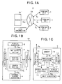
As shown in FIG. 1A, the navigation system S according to this
embodiment is provided with terminal units T, and a server SV. Each terminal
unit T sends to the server SV a terminal signal St indicative of information such
as vehicle's current position and travelling direction, as well as a request for
information to be presented to a driver, and also receives from the server SV a
terminal signal St indicative of various navigation process information
corresponding to the request, and presents the requested information to the
driver. Upon receipt of the terminal signal St as a server signal Ssv, the server
SV searches for map information, etc. to be presented to the driver on the
terminal unit T and performs processes (described below) including a route
guidance process for his or her vehicle on which the terminal unit T is mounted,
based on the received server signal Ssv, and then sends the processed results as
a server signal Ssv to the terminal unit T. The terminal unit T and the server SV
communicate with each other via the Internet IN.
The server SV can obtain VICS information via the Internet.
As shown in FIG. 1A, one sever SV is connected to a plurality of terminal
units T so that the server SV can send to the terminal units T map and other
information on a time division basis.
Referring next to FIGS. 1B and 1C, the detailed configuration of the
navigation system S will be described.
As shown in FIG. 1B, the server SV comprises a CPU 1, a display
subsystem 2, an input subsystem 3, an external storage subsystem 4 such as a
hard drive, and an interface 5.
In the above configuration, the interface 5 appropriately interfaces an input
server signal Ssv from the Internet IN to output the signal Ssv to the CPU 1 as a
to-be-processed server signal Sssv, and also appropriately interfaces a processed
server signal Sssv from the CPU 1 to output the signal Sssv to a terminal unit T
as a server signal Ssv via the Internet IN.
The external storage subsystem 4 stores all information requisite for a
navigation process performed by the navigation system S according to this
embodiment, and outputs such information to the CPU 1 as a memory signal Sm,
as needed. The information includes map information for display on each
terminal unit T, various information used for a routing process (described below),
point information for performing the navigation process according to this
embodiment (more specifically, position information about points indicated on a
map for display on the terminal unit T and descriptions of these points), and
information about a user of the terminal unit T.
The CPU 1 is provided with a map output section 1a, a routing section 1b,
and a search section 1c for its processing.
The map output section 1a searches for and reads, based on the request
input as the to-be-processed server signal Sssv, map information corresponding
to the request from among the map information stored in the external storage
subsystem 4 as a memory signal Sm, and outputs the memory signal Sm to the
terminal unit T via the interface 5 and the Internet IN as a processed server
signal Sssv.
The routing section 1b calculates and finds, based on the request input as
the to-be-processed server signal Sssv, a route along which the vehicle should
travel, using the map information stored in the external storage subsystem 4,
searches and reads the map information including the calculated and found
route as a memory signal Sm, and outputs the memory signal Sm to the terminal
unit T via the interface 5 and the Internet IN as a processed server signal Sssv.
Concurrently therewith, the routing section 1b generates route guidance
information for guiding the vehicle having the terminal unit T aboard to move
along the searched route, and outputs the searched result to the terminal unit T
via the interface 5 and the Internet IN as a processed server signal Sssv.
The search section 1c searches for and reads, as a memory signal Sm, the
point information, etc. stored in the external storage subsystem 4 based on the
request input as the to-be-processed server signal Sssv, and outputs the memory
signal Sm to the terminal unit T via the interface 5 and the Internet IN as a
processed server signal Sssv.
The input subsystem 3 generates, upon entry of information necessary for
the above operations, an input signal Sin corresponding to the entered
information, and outputs the generated input signal Sin to the CPU 1. After
having received the signal Sin, the CPU 1 performs its processing accordingly.
Information to be presented to an operator of the server SV during the
above operations is output to the display subsystem 2 as a display signal Sdp so
that information corresponding to the display signal Sdp is displayed on the
display subsystem 2.
Then, as shown in FIG. 1C, a terminal unit T is provided with a processing
subsystem 10 including a CPU and a memory, a memory 11, a sensor subsystem
12, a display subsystem 13, a speech output subsystem 14, a
transmitter/receiver 15 such as a cellular telephone, and an input subsystem 16.
In this configuration, the transmitter/receiver 15 appropriately interfaces
an input terminal signal St from the Internet IN to output a to-be-processed
terminal signal Stt to the processing subsystem 10, and similarly interfaces a
processed terminal signal Stt from the processing subsystem 10 to output a
terminal signal St to the server SV via the Internet IN.
The sensor subsystem 12 is provided with a GPS receiver, a vehicle-speed
sensor, and an acceleration sensor, and outputs information indicative of the
vehicle's current position and attitude, etc. from the receiver and sensors, to the
processing subsystem 10 as a sensor signal Ssc. The GPS receiver outputs
absolute position information (absolute geographical latitude and longitude data)
about a vehicle carrying the terminal unit T aboard, based on position
information contained in GPS radio waves from a GPS satellite in orbit. The
vehicle-speed sensor outputs distance and speed information by computing a
distance traveled and a vehicle's speed based on so-called vehicle-speed pulses
from a front wheel of the vehicle. The acceleration sensor detects turning angles
and vertical inclinations of the vehicle to output information about the vehicle's
travelling direction.
The input subsystem 16 generates, upon specification of a map for display
on the display subsystem 13 or upon specification of a setting for the navigation
process according to this embodiment such as a destination, an input signal Sin
corresponding to the specification, and outputs the generated input signal Sin to
the processing subsystem 10.
Based on these signals Ssc and Sin, the processing subsystem 10
generates information including current position information about the vehicle
carrying the terminal unit T aboard, as well as a request, etc. corresponding to
the specification made at the input subsystem 16. Then, the processing
subsystem 10 outputs such generated information, request, etc. as a
to-be-processed terminal signal Stt to the server SV via the transmitter/receiver
15.
Upon receipt of a processed terminal signal Stt via the Internet IN and the
transmitter/receiver 15 from the server SV that has processed the
to-be-processed signal Stt based on the current position information, request,
etc., the processing subsystem 10 outputs the map information contained in the
received processed terminal signal Stt to the display subsystem 13 as a display
signal Sdp to display the map information thereon. The display subsystem 13
additionally displays information such as map information along the route
generated by the routing section 1b within the server SV or routing information
based on the route guidance information.
Of the route guidance information, audible messages to be given to the
driver of the vehicle is output to the speech output subsystem 14 as an audio
signal Sad, to implement the route guidance.
The processing subsystem 10 temporarily stores some information, such
as the map information sent from the server SV, in the memory 11 as a memory
signal Sm, which is then read, as needed, for proper indicator light processing.
(Navigation process)
The navigation process to be performed by the navigation system S
having the above configuration will be described. Referring to FIGS. 2 to 4,
the description starts with steps taken by the server SV.
Referring to the flowchart shown in FIG. 2, a map search process will be
described, in which steps are taken to search a map for display on the display
subsystem 13 of any of the terminal units T.
In the map search process, the server SV constantly checks whether or not
any terminal unit T sends a request for a map for display (step S1). If not (step
S1; NO), the server SV waits. If so (step S1; YES), the server SV determines
whether or not the requesting terminal unit T is authorized by the navigation
system S according to this embodiment (step S2).
Upon completion of the authorization step, the server SV causes the map
output section 1a to search for appropriate map information based on the
received request by referring to the map information stored in the external
storage subsystem 4 (steps S3 and S4). When the search step S4 is completed
(step S4; YES), the searched map information is sent to the terminal unit T (step
S5).
The server SV keeps checking whether or not all of the map information
has been sent (step S6). If not (step S6; NO), the server SV continues sending
the rest of the information, and if so (step S6; YES), it brings the series of map
search steps to an end.
It should be noted that according to this embodiment, the map information
is sent while divided into segments. That is, of the total route along which to
guide the vehicle, only a map information segment that is immediately necessary
is sent, and this is repeated multiple times until the vehicle reaches the
destination. This will be detailed below.
Referring next to the flowchart shown in FIG. 3A, a route calculation
process will be described, in which steps are taken to calculate a route along
which to guide a vehicle carrying any of the terminal units T thereon.
In the route calculation process, the server SV always checks whether or
not a request containing a place of departure, a destination, and routing
conditions (more specifically, whether or not highways are preferred, or
calculations are to be made so that the vehicle drives along specific roads, etc.)
has been sent from any terminal unit T (step S20). If not (step S20; NO), the
server SV waits, and if so (step S20; YES), the server SV then determines whether
or not that requesting terminal unit T is authorized by the navigation system S
according to this embodiment (step S21).
Upon completion of the authorization step, the server SV extracts and
acquires user information related to a user who owns the authorized terminal
unit T from the external storage subsystem 4 (step S22), and then causes its
routing section 1b to perform prescribed route calculation steps based on the
destination, etc. contained in the request as well as the acquired user
information (steps S23 and S24). When these route calculating steps are
completed (step S24; YES), the server SV temporarily loads the calculated route
information into the memory within the CPU 1, to terminate the route calculation
process. The server SV may send the calculated route information to the
terminal unit T so that the unit T causes its display subsystem 13 to display the
received route information thereon.
It should be noted that according to this embodiment, the route calculation
process is carried out by dividing the route into segments. That is, of the entire
route along which to guide the vehicle, route calculations are made only for a
route segment that is immediately needed, and this is repeated a plurality of
times until the vehicle reaches the destination. This will be further explained
below.
Referring then to the flowchart shown in FIG. 3B, a route guidance process
will be described, in which steps are taken to guide a vehicle along the calculated
route, the vehicle carrying any of the terminal units T aboard.
In the route guidance process, the server SV constantly checks whether or
not the terminal unit T has sent a request for starting route guidance (step S25).
If not (step S25; NO), the server SV waits, and if so (step S25; YES), it determines
whether or not the requesting terminal unit T is authorized by the navigation
system S according to this embodiment (step S26).
Upon completion of the authorization step, the server SV extracts and
acquires user information related to a user who owns the authorized terminal
unit T from the external storage subsystem 4 for confirmation (step S27), and
causes its routing section 1b to perform prescribed route guidance steps (steps
S28 and S29) according to the request. Upon completion of the route
guidance process (step S29; YES), the server SV terminates the route guidance
process, which includes a step of acquiring current position information
indicative of the vehicle's current position, a step of determining whether or not
the acquired current position is on the previously calculated route, and a step
of calculating the relationship between the vehicle's current position and a
point of interest (an intersection for turn, a landmark, or the like) along the
route, and sending the calculated relationship to the terminal unit T to inform
the driver of the calculated relationship.
It should be noted that according to this embodiment, the route guidance
process is carried out by dividing the guidance processing into segments. That
is, of the total route along which to guide the vehicle, guidance calculations are
performed only for a guidance segment that is currently necessary, and this is
repeated multiple times until the vehicle reaches the destination. This will be
detailed below.
Referring next to the flowchart shown in FIG. 4, an information search
process will be described, in which steps are taken to search information which
is to be given to the driver of any of the terminal units T and which is related to
the navigation process.
In the information search process, the server SV keeps checking whether
or not any terminal unit T has sent a request for information to be given to the
driver (step S10). If not (step S10; NO), the server SV waits. If so (step S10;
YES), the server SV determines whether or not that requesting terminal unit T is
authorized by the navigation system S according to this embodiment (step S11).
Upon completion of the authorization step, the server SV then causes its
search section 1c to search for appropriate information from among the
information stored in the external storage subsystem 4 based on the received
request (steps S12 and S13). When the search is completed (step S13; YES), the
server SV sends the searched information to the terminal unit T (step S14).
In the meantime, the server keeps checking whether or not all of the
searched information has been sent (step S15). If not (step S15; NO), the server
SV continues sending the rest of the information, and if so (step S15; YES), it
brings the series of information search steps to an end.
As mentioned above, according to this embodiment, in certain processes of
the navigation process, processing is not performed for the total route at once,
but is performed by dividing the total route into segments, and only for one
processing segment at a time which is immediately necessary. Referring now to
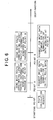
FIGS. 5 and 6, such segmented processing will be described.
FIGS. 5 and 6 are flowcharts showing the segmented processing according
to this embodiment. As shown in the figures, when a user specifies a
destination at a starting point (point of departure), the corresponding terminal
unit T sends to the server SV requests for the map search process (FIG. 2), the
rout calculation process (FIG. 3A), and the route guidance process (FIG. 3B). In
response to the requests, the server SV performs the series of steps shown in
FIGS. 2, 3A and 3B, with the respective steps being carried out only for a
segment of immediate need for travelling from the starting point. As shown in
FIGS. 5 and 6, the server SV makes initial route calculations (FIG. 5), etc., and
then sends to the terminal unit T only a route data segment and a guidance data
segment which the user currently needs for driving from the starting point.
Then, at a point A shown in FIGS. 5 and 6, when recognizing that the data
acquired by the initial route calculations, etc. has been exhausted so that further
guidance cannot be given, the terminal unit T sends new requests to the server
SV. In response to the new requests, the server SV performs the series of steps
shown in FIGS. 2, 3A and 3B once again, with the processing being limited only
to a segment currently necessary for travelling from the point A. In addition, the
processing such as the route calculations takes into account the latest traffic
information acquired upon passage at the point A. The latest traffic information
is based on VICS information (FIG. 1) which the server SV has acquired via the
Internet IN.
In this way, as shown in FIGS. 5 and 6, the server SV carries out the
updating route calculations (FIG. 5), etc., and sends to the terminal unit T
updated route data (route calculation results) and guidance data immediately
necessary for driving from the point A.
Then, when the vehicle arrives at a point B shown in FIGS. 5 and 6, and
when the terminal unit T recognizes that the data acquired by the updating route
calculations, etc. at the point A is no longer usable for further guidance, the
terminal unit T sends new requests to the server SV. Upon receipt of the new
requests, the server SV performs the series of steps shown in FIGS. 2, 3A and 3B
once again, with the processing covering only a segment of immediate need for
travelling from the point B. In addition, the processing such as the route
calculations considers the latest traffic information acquired upon passage at the
point B. That is, as shown in FIGS. 5 and 6, the server SV performs the
updating route calculations (FIG. 5), etc., and sends to the terminal unit T
updated route data (route calculation results) and guidance data immediately
required for driving from the point B.
Thus, according to this embodiment, processing is performed by dividing
the data necessary for guidance into segments, and only one immediately
necessary data segment is processed and sent to the terminal unit T from the
server SV every time the terminal unit T requests to do so. Therefore, the
terminal unit T can reduce the storage capacity of its memory 11 that stores the
data sent from the server SV. Moreover, the server SV sends to the terminal unit
the data segments that are updated, and hence the terminal unit T can acquire
information reflecting the latest traffic conditions at any time. For example, the
user can select the best route always appropriately according to traffic
information about accidents, congestions, etc.
The timing for sending new data can be selective. For example, the server
SV may send updated data to the terminal unit T at predetermined time intervals
(e.g., once every 5 minutes) or before the vehicle gets out of a geographical area
covered by any previous guidance data segment. In the latter case, the terminal
unit T may determine whether or not it sends new requests based on a
relationship between a previously received guidance data segment and a current
vehicle position detected by the sensor subsystem 12.
While the above-disclosed embodiment refers to the example in which the
server SV carries out route calculations in dependence on requests from the
terminal unit T, the server SV may constantly perform route calculations offline
without dependence on requests, and sends the latest route calculation results,
etc. to the terminal unit T upon receipt of a request.
According to the communication navigation method and system, etc. of the
present invention, the server sends to the navigation terminal information
necessary for guidance in segments, whereby the navigation terminal can reduce
the storage capacity of its memory. Furthermore, since the updated information
segment is sent in the fourth procedure, the navigation terminal can acquire
information reflecting the latest road conditions, etc.