WO2023105702A1 - 線状物を抽出する装置、方法及びプログラム - Google Patents
線状物を抽出する装置、方法及びプログラム Download PDFInfo
- Publication number
- WO2023105702A1 WO2023105702A1 PCT/JP2021/045241 JP2021045241W WO2023105702A1 WO 2023105702 A1 WO2023105702 A1 WO 2023105702A1 JP 2021045241 W JP2021045241 W JP 2021045241W WO 2023105702 A1 WO2023105702 A1 WO 2023105702A1
- Authority
- WO
- WIPO (PCT)
- Prior art keywords
- point cloud
- point
- cable
- group
- line
- Prior art date
- Legal status (The legal status is an assumption and is not a legal conclusion. Google has not performed a legal analysis and makes no representation as to the accuracy of the status listed.)
- Ceased
Links
Images







Classifications
-
- G—PHYSICS
- G06—COMPUTING OR CALCULATING; COUNTING
- G06V—IMAGE OR VIDEO RECOGNITION OR UNDERSTANDING
- G06V20/00—Scenes; Scene-specific elements
- G06V20/50—Context or environment of the image
- G06V20/56—Context or environment of the image exterior to a vehicle by using sensors mounted on the vehicle
- G06V20/58—Recognition of moving objects or obstacles, e.g. vehicles or pedestrians; Recognition of traffic objects, e.g. traffic signs, traffic lights or roads
-
- G—PHYSICS
- G01—MEASURING; TESTING
- G01B—MEASURING LENGTH, THICKNESS OR SIMILAR LINEAR DIMENSIONS; MEASURING ANGLES; MEASURING AREAS; MEASURING IRREGULARITIES OF SURFACES OR CONTOURS
- G01B11/00—Measuring arrangements characterised by the use of optical techniques
- G01B11/02—Measuring arrangements characterised by the use of optical techniques for measuring length, width or thickness
- G01B11/03—Measuring arrangements characterised by the use of optical techniques for measuring length, width or thickness by measuring coordinates of points
-
- G—PHYSICS
- G01—MEASURING; TESTING
- G01B—MEASURING LENGTH, THICKNESS OR SIMILAR LINEAR DIMENSIONS; MEASURING ANGLES; MEASURING AREAS; MEASURING IRREGULARITIES OF SURFACES OR CONTOURS
- G01B21/00—Measuring arrangements or details thereof, where the measuring technique is not covered by the other groups of this subclass, unspecified or not relevant
- G01B21/02—Measuring arrangements or details thereof, where the measuring technique is not covered by the other groups of this subclass, unspecified or not relevant for measuring length, width, or thickness
- G01B21/04—Measuring arrangements or details thereof, where the measuring technique is not covered by the other groups of this subclass, unspecified or not relevant for measuring length, width, or thickness by measuring coordinates of points
-
- G—PHYSICS
- G01—MEASURING; TESTING
- G01B—MEASURING LENGTH, THICKNESS OR SIMILAR LINEAR DIMENSIONS; MEASURING ANGLES; MEASURING AREAS; MEASURING IRREGULARITIES OF SURFACES OR CONTOURS
- G01B21/00—Measuring arrangements or details thereof, where the measuring technique is not covered by the other groups of this subclass, unspecified or not relevant
- G01B21/20—Measuring arrangements or details thereof, where the measuring technique is not covered by the other groups of this subclass, unspecified or not relevant for measuring contours or curvatures, e.g. determining profile
-
- G—PHYSICS
- G01—MEASURING; TESTING
- G01C—MEASURING DISTANCES, LEVELS OR BEARINGS; SURVEYING; NAVIGATION; GYROSCOPIC INSTRUMENTS; PHOTOGRAMMETRY OR VIDEOGRAMMETRY
- G01C15/00—Surveying instruments or accessories not provided for in groups G01C1/00 - G01C13/00
Definitions
- the apparatus and methods of the present disclosure comprise: Obtaining point cloud data representing three-dimensional coordinates and a movement trajectory when measuring the point cloud data, By repeatedly counting the number of point groups within a certain distance from the point group on the moving trajectory, the point group of the linear object is extracted.
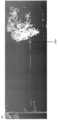
- FIG. 3 shows an example of a method for extracting linear objects according to the present disclosure.
- the present disclosure detects whether or not a point group exists on the travel trajectory using the travel trajectory of the vehicle (S1).
- a point d2 exists on the travel locus.
- the point d2 is set as the first point group N.
- a specific example of the first point group N is shown in FIG.
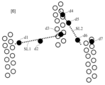
- a point cloud group for each cable is created by performing straight line detection on the point cloud included in the point cloud group of the cable candidate and dividing the point cloud group for each detected straight line (S3). For example, as shown in FIG. 6, a straight line SL1 connecting points d1, d2 and d3 and a straight line SL2 connecting points d4, d5 and d6 are detected. Then, it is divided into a point group (d1, d2, d3) of the straight line SL1 and a point group (d4, d5, d6) of the straight line SL2.
- any algorithm such as Hough transform can be used for straight line detection.
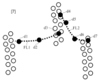
- the approximation line obtained by fitting is extended for each point cloud group in cable units, and the point clouds on the extended approximation line are included in the same point cloud group (S4).
- S4 point cloud group
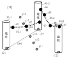
- an approximate line FL1 obtained by fitting points d1, d2 and d3 is obtained, and an approximate line FL2 obtained by fitting points d4, d5 and d6 is obtained.
- the point d7 located on the approximation line FL2 is added to the point cloud group of the points d4, d5, and d6.
- the present disclosure can extract the point cloud of cable 92 .
- FIG. 8 shows a system configuration example of the present disclosure.
- a system according to the present disclosure comprises a device 10 according to the present disclosure and an MMS 20 .
- the device 10 includes an external data reading unit 11 , a set value storage unit 15 , a point group determination unit 12 , a parameter calculation unit 13 and a calculation result storage unit 14 .
- the device 10 can also be realized by a computer and a program, and the program can be recorded on a recording medium or provided through a network.
- the external data reading unit 11, the setting value storage unit 15, the parameter calculation unit 13, and the calculation result storage unit 14 can also be realized by known ones.
- step S2 the point group determination unit 12 executes the following steps S21 to S25.
- Point groups within a certain distance DN from the detected point group are detected, and the number of detected point groups is counted (S21). If the count number is greater than the set value, it is not determined as a cable candidate point group. If the counted number is equal to or less than the upper limit of the number of points, the point group N and the point group M are taken as the point group G (S22). Also for the point group M, the number of point groups L within the distance between the point groups is counted (S23). If the counted number is equal to or less than the upper limit of the number of points, the point group L is taken as the point group G (S24). By repeating the detection and counting of point groups within the inter-point group distance, a point group G is created (S25).
- step S4 may be extended to the width of the road so as to cross the road.
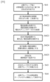
- FIG. 11 shows an example of the processing of the point group determination unit 12 in this case. Since steps S1 to S3 and S5 are the same as in FIG. 9, only step S4 will be described with reference to FIGS. 12 and 13. FIG.
- the coordinates c21 and c22 of the utility poles 91-1 and 91-2 closest to the coordinates c11 to c16 of each travel locus obtained in step S421 are retrieved (S423).
- a distance D91 between the coordinates c11 to c16 of the traveling locus and the coordinates c21 and c22 of the utility poles 91-1 and 91-2 is calculated and used as the road width (S424).
- the approximation line FL1 is extended to the road width D91 (S425). If there is a point group existing on the approximation line FL1, the point group is made to belong to the point group of points d1, d2, and d3 (S43).
- an approximation line FL2 exists on the extended approximation line FL1.
- the approximation line FL1 and the approximation line FL2 are connected.
- the point cloud coordinates of the point cloud group for each cable are stored as cable model information (S44).
- the approximation lines FL1 and FL2 are stored in the calculation result storage unit 14 as a cable model connected in a T shape.
- the present disclosure detects the point group N of the cable 92 existing on the traveling locus using the traveling locus data, which are the coordinates of the vehicle equipped with the MMS 20, and the distance from the point group N
- the point cloud group of the cable candidate is determined based on the D N and the number, and the point cloud of the cable portion is extracted based on the point clouds included in the point cloud group of the cable candidate.
Landscapes
- Physics & Mathematics (AREA)
- General Physics & Mathematics (AREA)
- Engineering & Computer Science (AREA)
- Multimedia (AREA)
- Theoretical Computer Science (AREA)
- Radar, Positioning & Navigation (AREA)
- Remote Sensing (AREA)
- Length Measuring Devices By Optical Means (AREA)
- Length Measuring Devices With Unspecified Measuring Means (AREA)
Abstract
Description
3次元座標を表す点群データ及び前記点群データを測定時の移動軌跡を取得し、
移動軌跡上の点群から一定距離以内にある点群数を繰り返しカウントすることで、線状物の点群を抽出する。
・設定値記憶部15は、点群判定部12の処理で用いるパラメータを記憶する機能を有する。パラメータは、例えば、ステップS2において点d2を検索する点群データの範囲を定める検索範囲値、ステップS2において点d2を検出する際の走行軌跡からの距離、ステップS2において用いる「一定距離DN」を定める点群間距離、ステップS2において用いる「所定数」を定める点群数上限、ステップS4において近似線を求める際に用いる近似方法である。
・点群判定部12は、走行軌跡上の点群の検出(S1)、ケーブル候補の点群グループの作成(S2)、ケーブル単位の点群グループへの分割(S3)、近似線の生成及び近似線上の点群の検知(S4)を行う機能を有する。
・パラメータ計算部13は、ケーブル地上高、弛度、スパン長を計算する機能を有する。
・計算結果記憶部14は、点群判定部12及びパラメータ計算部13で計算された値を記憶する機能を有する。
外部データ読込部11が、点群データと走行軌跡データをMMS20から読み込み(S01)、点群判定部12が設定値を設定値記憶部15から読み込む(S02)。
ステップS1では、走行軌跡情報と検索範囲値に基づいて走行軌跡上に検出範囲を設定し(S11)、点群検索範囲に存在する点群Nを探索する(S12)。これにより、走行軌跡上の点群を検出する。
ステップS4では、点群判定部12が、ケーブル単位の点群グループを例えば、一次直線、二次曲線又はカテナリ曲線などで近似を行い(S41)、延長する(S42)。延長上に存在する点群もケーブル単位の点群グループに所属させ(S43)、ケーブルモデルとする(S44)。図10に、図4の点群Nから作成されたケーブルモデルの一例を示す。
最後に、パラメータ計算部13が、ケーブルモデルから、ケーブル地上高、弛度、スパン長などを計算する(S5)。計算結果記憶部14が、点群判定部12で作成されたケーブルモデル及びパラメータ計算部13の計算結果を記憶する。
走行軌跡の座標c11~c16を取得する(S421)。座標c11~c16の間隔は、任意であり、例えば1m毎などの等間隔にすることができる。
電柱91の座標c21~c23を取得する(S422)。ここで、電柱91の座標c21~c23は、電柱91の地理的な位置を格納した設備DBから取得してもよいし、電柱91の測定された点群(図2に示す白丸)を用いて作成された電柱モデルの座標から取得してもよい。
ステップS421で取得した各走行軌跡の座標c11~c16から最も近い電柱91-1及び91-2の座標c21及びc22を検索する(S423)。
走行軌跡の座標c11~c16と電柱91-1及び91-2の座標c21及びc22の距離D91を算出し、道路幅とする(S424)。
図13に示すように、近似線FL1を道路幅D91まで延長する(S425)。
近似線FL1上に存在する点群が存在する場合、その点群を点d1、d2、d3の点群グループに所属させる(S43)。本実施形態では、延長された近似線FL1上には近似線FL2が存在する。この場合、近似線FL1と近似線FL2を接続する。
ケーブル単位の点群グループの点群座標をケーブルモデル情報として保存する(S44)。このとき、近似線FL1及びFL2をT字状に接続されたケーブルモデルとして計算結果記憶部14に保存する。
11:外部データ読込部
12:点群判定部
13:パラメータ計算部
14:計算結果記憶部
15:設定値記憶部
20:MMS
91、91-1、91-2、91-3:電柱
92:ケーブル
Claims (8)
- 3次元座標を表す点群データ及び前記点群データを測定時の移動軌跡を取得し、
移動軌跡上の点群から一定距離以内にある点群数を繰り返しカウントすることで、線状物の点群を抽出する、
装置。 - 抽出された線状物の点群から直線の検出を行い、
抽出された線状物の点群を、検出された直線ごとにグループ化する、
請求項1に記載の装置。 - 前記グループ化された点群から近似線を求め、
近似線上に配置されている点群を同一グループに含める、
請求項2に記載の装置。 - 前記近似線に、一次直線、二次曲線又はカテナリ曲線を用いる、
請求項3に記載の装置。 - 前記線状物は、道路を横断する架空ケーブルであり、
道路を横断するように、前記近似線を延長する、
請求項3又は4に記載の装置。 - 前記移動軌跡から最も近い電柱までの距離を用いて道路幅を算出し、
前記近似線を道路幅まで延長する、
請求項5に記載の装置。 - 3次元座標を表す点群データ及び前記点群データを測定時の移動軌跡を取得し、
移動軌跡上の点群から一定距離以内にある点群数を繰り返しカウントすることで、線状物の点群を抽出する、
方法。 - 請求項1から6のいずれかに記載の装置に備わる各機能部としてコンピュータを実現させるためのプログラム。
Priority Applications (3)
| Application Number | Priority Date | Filing Date | Title |
|---|---|---|---|
| PCT/JP2021/045241 WO2023105702A1 (ja) | 2021-12-09 | 2021-12-09 | 線状物を抽出する装置、方法及びプログラム |
| US18/716,113 US20250046097A1 (en) | 2021-12-09 | 2021-12-09 | Device, method and program for extracting linear objects |
| JP2023565794A JP7652289B2 (ja) | 2021-12-09 | 2021-12-09 | 線状物を抽出する装置、方法及びプログラム |
Applications Claiming Priority (1)
| Application Number | Priority Date | Filing Date | Title |
|---|---|---|---|
| PCT/JP2021/045241 WO2023105702A1 (ja) | 2021-12-09 | 2021-12-09 | 線状物を抽出する装置、方法及びプログラム |
Publications (1)
| Publication Number | Publication Date |
|---|---|
| WO2023105702A1 true WO2023105702A1 (ja) | 2023-06-15 |
Family
ID=86729999
Family Applications (1)
| Application Number | Title | Priority Date | Filing Date |
|---|---|---|---|
| PCT/JP2021/045241 Ceased WO2023105702A1 (ja) | 2021-12-09 | 2021-12-09 | 線状物を抽出する装置、方法及びプログラム |
Country Status (3)
| Country | Link |
|---|---|
| US (1) | US20250046097A1 (ja) |
| JP (1) | JP7652289B2 (ja) |
| WO (1) | WO2023105702A1 (ja) |
Citations (7)
| Publication number | Priority date | Publication date | Assignee | Title |
|---|---|---|---|---|
| WO2020080088A1 (ja) * | 2018-10-15 | 2020-04-23 | 三菱電機株式会社 | 情報処理装置 |
| WO2020129614A1 (ja) * | 2018-12-17 | 2020-06-25 | 日本電信電話株式会社 | 設備状態検出装置、設備状態検出方法、及びプログラム |
| WO2020225886A1 (ja) * | 2019-05-08 | 2020-11-12 | 日本電信電話株式会社 | 点群解析装置、方法、及びプログラム |
| WO2020225887A1 (ja) * | 2019-05-08 | 2020-11-12 | 日本電信電話株式会社 | 点群解析装置、推定装置、点群解析方法、およびプログラム |
| WO2021033249A1 (ja) * | 2019-08-19 | 2021-02-25 | 日本電信電話株式会社 | 線状構造物の検出装置、検出方法及び検出プログラム |
| WO2021038647A1 (ja) * | 2019-08-23 | 2021-03-04 | 日本電信電話株式会社 | 地上高測定方法、地上高測定装置、及びプログラム |
| JP2021039390A (ja) * | 2019-08-30 | 2021-03-11 | 株式会社日野 | 道路状況計測装置、方法及びプログラム |
Family Cites Families (2)
| Publication number | Priority date | Publication date | Assignee | Title |
|---|---|---|---|---|
| JP5981886B2 (ja) | 2013-06-17 | 2016-08-31 | 日本電信電話株式会社 | 点群解析処理装置、点群解析処理方法、及びプログラム |
| JP6531051B2 (ja) | 2016-02-29 | 2019-06-12 | 日本電信電話株式会社 | 設備状態検出方法および装置 |
-
2021
- 2021-12-09 JP JP2023565794A patent/JP7652289B2/ja active Active
- 2021-12-09 WO PCT/JP2021/045241 patent/WO2023105702A1/ja not_active Ceased
- 2021-12-09 US US18/716,113 patent/US20250046097A1/en active Pending
Patent Citations (7)
| Publication number | Priority date | Publication date | Assignee | Title |
|---|---|---|---|---|
| WO2020080088A1 (ja) * | 2018-10-15 | 2020-04-23 | 三菱電機株式会社 | 情報処理装置 |
| WO2020129614A1 (ja) * | 2018-12-17 | 2020-06-25 | 日本電信電話株式会社 | 設備状態検出装置、設備状態検出方法、及びプログラム |
| WO2020225886A1 (ja) * | 2019-05-08 | 2020-11-12 | 日本電信電話株式会社 | 点群解析装置、方法、及びプログラム |
| WO2020225887A1 (ja) * | 2019-05-08 | 2020-11-12 | 日本電信電話株式会社 | 点群解析装置、推定装置、点群解析方法、およびプログラム |
| WO2021033249A1 (ja) * | 2019-08-19 | 2021-02-25 | 日本電信電話株式会社 | 線状構造物の検出装置、検出方法及び検出プログラム |
| WO2021038647A1 (ja) * | 2019-08-23 | 2021-03-04 | 日本電信電話株式会社 | 地上高測定方法、地上高測定装置、及びプログラム |
| JP2021039390A (ja) * | 2019-08-30 | 2021-03-11 | 株式会社日野 | 道路状況計測装置、方法及びプログラム |
Also Published As
| Publication number | Publication date |
|---|---|
| JP7652289B2 (ja) | 2025-03-27 |
| US20250046097A1 (en) | 2025-02-06 |
| JPWO2023105702A1 (ja) | 2023-06-15 |
Similar Documents
| Publication | Publication Date | Title |
|---|---|---|
| KR102125959B1 (ko) | 포인트 클라우드 데이터 사이의 매칭 관계를 확정하는 방법 및 장치 | |
| CN108564874A (zh) | 地面标志提取的方法、模型训练的方法、设备及存储介质 | |
| CN110717464B (zh) | 一种基于雷达数据的铁路路基病害智能识别方法 | |
| CN107679458B (zh) | 一种基于K-Means的道路彩色激光点云中道路标线的提取方法 | |
| CN108562885B (zh) | 一种高压输电线路机载LiDAR点云提取方法 | |
| CN106500594A (zh) | 融合反射强度和几何特征的铁路轨道半自动检测方法 | |
| WO2021254019A1 (zh) | 协同构建点云地图的方法、设备和系统 | |
| CN113887391A (zh) | 用于识别路面标识的方法、装置以及自动驾驶车辆 | |
| Elias et al. | Automatic generation and application of landmarks in navigation data sets | |
| CN112862844A (zh) | 基于车载点云数据的道路边界交互式提取方法 | |
| WO2021255798A1 (ja) | ワイヤモデル生成装置、ワイヤモデル生成方法及びワイヤモデル生成プログラム | |
| CN116242316B (zh) | 刚性接触网定位点实时检测的方法及装置 | |
| CN114111814A (zh) | 高精地图数据处理方法、装置、电子设备及存储介质 | |
| CN116299543B (zh) | 边坡形变监测方法、装置、飞行设备及存储介质 | |
| JP7652289B2 (ja) | 線状物を抽出する装置、方法及びプログラム | |
| WO2023095255A1 (ja) | 3次元モデルを作成する装置、方法及びプログラム | |
| CN114236566A (zh) | 激光系统的控制方法、装置、电子设备及可读存储介质 | |
| CN110807832B (zh) | 一种基于地面三维扫描仪的电力线自动提取方法 | |
| US12422278B2 (en) | Point clustering based on roadways | |
| CN107741222B (zh) | 一种无序点云的规则化方法及系统 | |
| CN107564015A (zh) | 一种基于多色级图像连通域的分割和标记方法及装置 | |
| CN117333521A (zh) | 一种用于无人扫地车的三维激光点云配准方法 | |
| CN118376225A (zh) | 局部连续性的矢量地图对齐方法、系统、设备及存储介质 | |
| CN115905588A (zh) | 三维测量数据的处理方法和装置、电子设备及存储介质 | |
| CN115797961A (zh) | 车道线变更检测方法、装置、电子设备及存储介质 |
Legal Events
| Date | Code | Title | Description |
|---|---|---|---|
| 121 | Ep: the epo has been informed by wipo that ep was designated in this application |
Ref document number: 21967199 Country of ref document: EP Kind code of ref document: A1 |
|
| ENP | Entry into the national phase |
Ref document number: 2023565794 Country of ref document: JP Kind code of ref document: A |
|
| WWE | Wipo information: entry into national phase |
Ref document number: 18716113 Country of ref document: US |
|
| NENP | Non-entry into the national phase |
Ref country code: DE |
|
| 122 | Ep: pct application non-entry in european phase |
Ref document number: 21967199 Country of ref document: EP Kind code of ref document: A1 |