WO2022215136A1 - 情報処理システム、伝搬環境データの処理方法、及びプログラム - Google Patents
情報処理システム、伝搬環境データの処理方法、及びプログラム Download PDFInfo
- Publication number
- WO2022215136A1 WO2022215136A1 PCT/JP2021/014537 JP2021014537W WO2022215136A1 WO 2022215136 A1 WO2022215136 A1 WO 2022215136A1 JP 2021014537 W JP2021014537 W JP 2021014537W WO 2022215136 A1 WO2022215136 A1 WO 2022215136A1
- Authority
- WO
- WIPO (PCT)
- Prior art keywords
- data
- meshes
- target area
- processing system
- information processing
- Prior art date
- Legal status (The legal status is an assumption and is not a legal conclusion. Google has not performed a legal analysis and makes no representation as to the accuracy of the status listed.)
- Ceased
Links
Images




Classifications
-
- H—ELECTRICITY
- H04—ELECTRIC COMMUNICATION TECHNIQUE
- H04W—WIRELESS COMMUNICATION NETWORKS
- H04W24/00—Supervisory, monitoring or testing arrangements
- H04W24/06—Testing, supervising or monitoring using simulated traffic
-
- H—ELECTRICITY
- H04—ELECTRIC COMMUNICATION TECHNIQUE
- H04W—WIRELESS COMMUNICATION NETWORKS
- H04W16/00—Network planning, e.g. coverage or traffic planning tools; Network deployment, e.g. resource partitioning or cells structures
- H04W16/18—Network planning tools
-
- H—ELECTRICITY
- H04—ELECTRIC COMMUNICATION TECHNIQUE
- H04W—WIRELESS COMMUNICATION NETWORKS
- H04W24/00—Supervisory, monitoring or testing arrangements
- H04W24/10—Scheduling measurement reports ; Arrangements for measurement reports
Definitions
- the present invention relates to an information processing system, a propagation environment data processing method, and a program.
- ray tracing (or ray tracing) as a method of performing radio wave propagation simulation used for area evaluation of wireless communication systems.
- radio waves (rays) transmitted from a transmitting point are reflected or diffracted by structures on the way and are traced as the trajectory of each ray to reach the receiving point.
- ray tracing By summing the power of all rays, we estimate the strength of the radio wave at the receiving point.
- environmental data propagation environment data
- LIDAR Light Detection and Ranging
- the embodiments of the present invention have been made in view of the above problems, and provide an information processing system that reduces the time required to read environmental data used in radio wave propagation simulation.
- an information processing system includes a dividing unit that divides a target area into a plurality of meshes of a predetermined size; An extraction unit that extracts height information of each of the plurality of meshes using data, and a creation unit that creates mesh data representing the height information of each of the plurality of meshes.
- FIG. 1 is a diagram (1) for explaining an outline of data processing according to the present embodiment
- FIG. FIG. 2 is a diagram (2) for explaining an outline of data processing according to the embodiment
- 5 is a flowchart illustrating an example of data processing according to the first embodiment
- 10 is a flowchart illustrating an example of data processing according to Example 2
- FIG. 1 is a diagram showing a configuration example of an information processing system according to this embodiment.
- the information processing system 1 implements a data processing unit 10, a storage unit 20, a simulation unit 30, an interface unit 40, and the like, for example, when a computer included in the information processing system 1 executes a predetermined program.
- a computer included in the information processing system 1 executes a predetermined program.
- each of the functional configurations described above is not limited to a physical machine (computer), and may be implemented by, for example, a program executed by a virtual machine on a cloud. Further, each functional configuration described above may be distributed and arranged in separate physical machines or virtual machines.
- the storage unit 20 preliminarily stores environmental data 22 of the target area for radio wave propagation simulation.
- the environmental data 22 may include, for example, CAD (Computer Aided Design) data 101, building data 102, point cloud data 103, and the like.
- the CAD data 101 includes, for example, data indicating the width, height, shape, position, etc. of each surface of objects (structures, buildings, etc.) in the target area, and information such as radio wave reflectance on each surface. It is three-dimensional CAD data including The CAD data 101 may be, for example, data input into a three-dimensional CAD or the like by an operator or the like, or data generated based on point cloud data obtained by LIDAR (Light Detection and Ranging) or the like. It can be.
- LIDAR Light Detection and Ranging
- the building data 102 is a database (building database) that includes data indicating the width, height, shape, position, etc. of each surface of the building in the target area, and information such as radio wave reflectance on each surface. .
- the building data 102 includes information on each aspect of the building, such as walls, floors, ceilings, and pillars.
- the point cloud data 103 is, for example, three-dimensional point cloud data representing the distance to each surface of an object within the target area, obtained using LIDAR or the like.
- the point cloud data 103 may be three-dimensional environmental map data or the like created based on three-dimensional point cloud information using SLAM (Simultaneous Localization and Mapping) technology.
- SLAM Simultaneous Localization and Mapping
- the storage unit 20 may be, for example, a storage server external to the information processing system 1, a cloud service, or the like.
- the data processing unit 10 uses the environment data 22 such as the CAD data 101, the building data 102, or the point cloud data 103, for example, to create mesh data of a predetermined area where the simulation unit 30 performs radio wave propagation simulation.
- the data processing unit 10 has, for example, a dividing unit 11, an extracting unit 12, a creating unit 13, and the like.
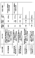
- the dividing unit 11 divides the target area for radio wave propagation simulation into a plurality of meshes. For example, the dividing unit 11 divides the target area 200 into a plurality of meshes 201 of a predetermined size, as shown in FIG. 2A. As an example, the dividing unit 11 divides the target area into a plurality of meshes 201 based on a regional mesh that divides the region into mesh areas based on latitude and longitude.
- Figure 3 shows the regional mesh division method posted on the website of the Statistics Bureau of the Ministry of Internal Affairs and Communications (https://www.stat.go.jp/data/mesh/m_tuite.html).
- the division unit 11 divides the target area 200 into a plurality of meshes 201 according to the regional mesh division method of FIG. Note that although the division method of the regional meshes shown in FIG. 3 only specifies up to 1/4 of the regional meshes, the division unit 11 can divide the regional meshes of FIG. It may be expanded like a 1/8 area mesh, a 1/16 area mesh, and so on.
- the dividing unit 11 divides the target area 200 based on the relative coordinates of the CAD data 101 or the like when the latitude and longitude information is not required, for example, when the simulation unit 30 performs an indoor radio wave propagation simulation. It may be divided into a plurality of meshes 201 .
- the extraction unit 12 extracts height information of each of the plurality of meshes 201 as shown in FIG. 2A from the environmental data 22, for example.
- the extracting unit 12 analyzes the CAD data 101 and sets the height information of the mesh 201 to 3 m when there is a structure with a height of 3 m in the mesh 201 .
- the extraction unit 12 analyzes the building data 102 or other environmental data 22 such as the point cloud data 103, and obtains the height information of the mesh 201. You can extract. Further, the extraction unit 12 analyzes the environment data 22 and sets the height information of the mesh 201 to 0 when the height information of the mesh 201 is not obtained.
- the creation unit 13 uses the height information 211 of each mesh extracted by the extraction unit 12 to create mesh data 21 as shown in FIG. 2B, for example.
- the x and y directions correspond to the position of each mesh 201 (for example, latitude, longitude, or row, column, etc.), and each data value corresponds to the height of each mesh 201. information. Therefore, for example, in the mesh data 21, the area 202 with the height information "3" has a structure with a height of 3 m, and the area 203 with the height information "6" has a structure with a height of, for example, "6". It shows that there is a structure with a height of 6m. Also, an area with height information of "0" indicates, for example, that there is no structure.
- the data processing unit 10 extracts the width, height, shape, position, etc. of each surface of an object (structure, building, etc.) in the target area from the environment data 22 stored in the storage unit 20. can be converted into two-dimensional mesh data 21 as shown in FIG. 2B. Moreover, since this mesh data 21 has the format of image data, it has the feature that it can be read and processed at high speed using a GPU (Graphics Processing Unit).
- GPU Graphics Processing Unit
- the simulation unit 30 reads the mesh data 21 created by the data processing unit 10 and the information such as the radio wave reflectance on each surface included in the environment data 22 from the storage unit 20 or the like, and performs radio wave propagation simulation of the target area. I do.
- the simulation unit 30 uses a GPU included in the computer to read the mesh data 21 in the form of image data at high speed.
- the simulation unit 30 uses the read mesh data 21 and information such as the radio wave reflectance on each surface to perform radio wave propagation simulation by ray tracing.
- radio waves (rays) transmitted from a transmitting point are reflected, diffracted, or transmitted by structures on the way, and then traced as the trajectory of each ray to reach the receiving point.
- the power of all arriving rays is summed to estimate the strength of the radio wave at the receiving point.
- the radio wave propagation simulation executed by the simulation unit 30 may use a method other than ray tracing.
- the data processing unit 10 can omit the process of creating the mesh data 21 when the simulation unit 30 performs the second and subsequent radio wave propagation simulations in the target area. .
- the interface unit 40 receives, from other systems, an API (Application Programming Interface) for using various functions provided by the information processing system 1, or a UI (User Interface) for the user to use the functions. offer.
- an API Application Programming Interface
- UI User Interface
- the user can use the interface unit 40 to request the data processing unit 10 to generate the mesh data 21 or to perform radio wave propagation simulation.
- the user uses the interface unit 40 to set or store parameters necessary for radio wave propagation simulation (for example, the position of the transmission point, the position of the reception point, the frequency, the transmission power, etc.)
- the environment data 22 can be registered in the unit 20 and the like.
- FIG. 4 is a flowchart illustrating an example of data processing according to the first embodiment; This process is an example of data processing in which the data processing unit 10 creates the mesh data 21 using the environmental data 22 .
- step S401 the dividing unit 11 of the data processing unit 10 generates, for example, a regional mesh as shown in FIG. 3 or an expanded regional mesh (eg, 1/8 regional mesh, 1/16 regional mesh, . etc.), select a regional mesh that is equal to or smaller than a predetermined size.
- the predetermined size may be set by the user or another system via the simulation unit 30, or may be preset in the data processing unit 10. Also good.
- step S402 the dividing unit 11 divides the target area to be processed into a plurality of meshes each having the size of the regional mesh. For example, as shown in FIG. 2A, the dividing unit 11 divides the target area 200 into a plurality of meshes 201 each having the size of the regional mesh selected in step S401.
- step S403 the extraction unit 12 of the data processing unit 10 acquires the environment data 22 of the target area from the storage unit 20, for example.
- the environment data 22 uses relative coordinates instead of latitude and longitude
- the latitude and longitude information of any point of the environment data 22 is obtained in advance and stored in the environment data 22, for example. Good to keep.
- the data processing unit 10 can associate the relative coordinates of the environmental data 22 with the latitude and longitude.
- step S404 the data processing unit 10 executes the processes of steps S405 to S408 for each of the plurality of meshes 201.
- step S405 the extraction unit 12 of the data processing unit 10 extracts the height information of the mesh 201 to be processed among the plurality of meshes 201 from the environment data 22. If there are a plurality of environmental data 22 such as the CAD data 101, the building data 102, and the point cloud data 103, the priority of each data should be determined in advance. In this case, the extraction unit 12 may try to acquire height information from data with a higher priority and extract height information that was acquired first.
- step S405 the creation unit 13 of the data processing unit 10 determines whether the environment data 22 has height information of the mesh 201 to be processed. For example, when the extraction unit 12 can acquire height information from the environment data 22, the creation unit 13 determines that there is height information. On the other hand, when the extraction unit 12 cannot acquire the height information from the environment data 22, the creation unit 13 determines that there is no height information. If there is height information, the creating unit 13 shifts the process to step S407. On the other hand, if there is no height information, the creating unit 13 shifts the process to step S408.
- the creation unit 13 When proceeding to step S407, the creation unit 13 inputs the height information extracted by the extraction unit 12 to the mesh data of the mesh 201 to be processed. On the other hand, when proceeding to step S408, the creating unit 13 inputs 0 to the mesh data of the mesh 201 to be processed.
- the data processing unit 10 can create mesh data 21 as shown in FIG.
- Example 2 In the first embodiment, an example in which the data processing unit 10 divides the target area into regional meshes as shown in FIG. 3, for example, has been described. However, the data processing unit 10 is not limited to this, and may divide the target area into a plurality of meshes of a predetermined size, for example, based on the relative coordinates of the environment data 22 (for example, the CAD data 101, etc.).
- FIG. 5 is a flowchart showing an example of data processing according to the second embodiment. This process shows another example of data processing in which the data processing unit 10 creates the mesh data 21 using the environmental data 22 . Among the processes shown in FIG. 5, the processes of steps S404 to S408 are the same as the processes of the first embodiment described with reference to FIG. .
- step S501 the dividing unit 11 of the data processing unit 10 acquires the environmental data 22 of the target area from the storage unit 20, for example. For example, when radio wave propagation simulation is performed on a certain floor in a building, the dividing unit 11 acquires the environmental data 22 of that floor.
- the dividing unit 11 divides the target area into a plurality of meshes of a predetermined size. For example, the dividing unit 11 divides the target area 200 into a plurality of meshes 201 of a predetermined size, as shown in FIG. 2A, based on the relative coordinates of the acquired environmental data 22 .
- step S404 the data processing unit 10 executes the processes of steps S405 to S408 for each of the plurality of meshes 201, as in the first embodiment. Thereby, the data processing unit 10 can create mesh data 21 as shown in FIG. 2B, for example.
- the simulation unit 30 may, for example, acquire the mesh data 21 and the building data 102 from the storage unit 20 and acquire the ceiling data from the building data 102 .
- the building data 102 has a smaller amount of data than the CAD data 101 or the point cloud data 103, etc., the effect of shortening the reading time of the environmental data used in the radio wave propagation simulation can be expected.
- the data processing unit 10 in addition to the mesh data 21 as shown in FIG. 2B, the data processing unit 10 generates another mesh data representing the ceiling height of each mesh in a similar format. You can create it.
- the simulation unit 30 acquires the mesh data 21 and another mesh data representing the ceiling height from the storage unit 20, and performs radio wave propagation simulation.
- both the mesh data 21 and the separate mesh data representing the ceiling height have image data formats, so the simulation unit 30 can read the data at high speed using the GPU.
- the information processing system 1 can be realized, for example, by causing a computer to execute a program describing the processing content described in this embodiment.
- the above program can be recorded on a computer-readable recording medium (portable memory, etc.), saved, or distributed. It is also possible to provide the above program through a network such as the Internet or e-mail.
- FIG. 6 is a diagram showing a hardware configuration example of the computer.
- a computer 600 in FIG. 6 includes a drive device 1000, an auxiliary storage device 1002, a memory device 1003, a CPU 1004, an interface device 1005, a display device 1006, an input device 1007, an output device 1008, and a GPU 1009, which are interconnected via a bus B. etc.
- a program that implements processing in the computer 600 is provided by a recording medium 1001 such as a CD-ROM or memory card, for example.
- a recording medium 1001 such as a CD-ROM or memory card, for example.
- the program is installed from the recording medium 1001 to the auxiliary storage device 1002 via the drive device 1000 .
- the program does not necessarily have to be installed from the recording medium 1001, and may be downloaded from another computer via the network.
- the auxiliary storage device 1002 stores installed programs, as well as necessary files and data.
- the memory device 1003 reads and stores the program from the auxiliary storage device 1002 when a program activation instruction is received.
- the CPU 1004 implements functions related to each unit described in this embodiment according to programs stored in the memory device 1003 .
- the interface device 1005 is used as an interface for connecting to the network.
- a display device 1006 displays a GUI or the like by a program.
- An input device 1007 is composed of a keyboard, a mouse, buttons, a touch panel, or the like, and is used to input various operational instructions.
- the output device 1008 outputs the calculation result. Note that the information processing system 1 may not include either or both of the display device 1006 and the input device 1007 .
- the GPU 1009 is a processor that executes various processes mainly related to image processing (particularly 3D graphics processing) faster than the CPU 1004 .
- This specification discloses an information processing system, a propagation environment data processing method, and a program according to at least the following items.
- (Section 1) a dividing unit that divides the target area into a plurality of meshes of a predetermined size; an extraction unit that extracts height information of each of the plurality of meshes using environmental data representing the position and shape of an object in the target area; a creation unit that creates mesh data representing the height information of each of the plurality of meshes; An information processing system.
- (Section 2) 2. The information processing system according to claim 1, wherein the mesh data has a data format readable by a GPU.
- the information processing system according to any one of items 1 and 2, wherein the dividing unit divides the target area into a plurality of regional meshes based on latitude and longitude.
- (Section 4) 3. The information processing according to item 1 or 2, wherein the dividing unit divides the target area into a plurality of meshes of the predetermined size based on relative coordinates of three-dimensional data included in the environment data. system.
- (Section 5) 5.
- the information processing system according to any one of items 1 to 4, wherein the environment data includes three-dimensional CAD data representing positions and shapes of structures in the target area.
- the environmental data includes three-dimensional point group information representing positions and shapes of structures in the target area.
- (Section 7) The information processing system according to any one of items 1 to 6, wherein the environment data includes a building database representing the outside or inside positions and shapes of buildings in the target area. (Section 8) 3. The information processing system according to claim 2, comprising a simulation unit that reads the mesh data with a GPU and performs radio wave propagation simulation.
- (Section 9) Information processing system A process of dividing the target area into a plurality of meshes of a predetermined size; A process of extracting height information of each of the plurality of meshes using environmental data representing the position and shape of an object in the target area; a process of creating mesh data representing the height information of each of the plurality of meshes; A method of processing propagation environment data that performs (Section 10) information processing system, A process of dividing the target area into a plurality of meshes of a predetermined size; A process of extracting height information of each of the plurality of meshes using environmental data representing the position and shape of an object in the target area; a process of creating mesh data representing the height information of each of the plurality of meshes; The program that causes the to run.
Landscapes
- Engineering & Computer Science (AREA)
- Computer Networks & Wireless Communication (AREA)
- Signal Processing (AREA)
- Management, Administration, Business Operations System, And Electronic Commerce (AREA)
Abstract
Description
図1は、本実施形態に係る情報処理システムの構成例を示す図である。情報処理システム1は、例えば、情報処理システム1が備えるコンピュータが所定のプログラムを実行することにより、データ処理部10、記憶部20、シミュレーション部30、及びインタフェース部40等を実現している。なお、上記の各機能構成は、物理マシン(コンピュータ)に限られず、例えば、クラウド上の仮想マシンが実行するプログラムにより実現されるものであっても良い。また、上記の各機能構成は、別々の物理マシン、又は仮想マシンに分散して配置されていても良い。
続いて、本実施形態に係る伝搬環境データの処理方法の処理の流れについて説明する。
図4は、実施例1に係るデータ処理の例を示すフローチャートである。この処理は、データ処理部10が、環境データ22を用いて、メッシュデータ21を作成するデータ処理の一例を示している。
実施例1では、データ処理部10が、対象エリアを、例えば、図3に示すような地域メッシュに分割する場合の例について説明した。ただし、これに限られず、データ処理部10は、例えば、環境データ22(例えば、CADデータ101等)の相対座標に基づいて、対象エリアを所定のサイズの複数のメッシュに分割しても良い。
本実施形態に係る情報処理システム1は、例えば、コンピュータに、本実施形態で説明する処理内容を記述したプログラムを実行させることにより実現することができる。
本実施形態に係る技術によれば、電波伝搬のシミュレーションで用いる環境データの読み込み時間を短縮する情報処理システム1を提供することができる。
本明細書には、少なくとも下記各項の情報処理システム、伝搬環境データの処理方法、及びプログラムが開示されている。
(第1項)
対象エリアを所定のサイズの複数のメッシュに分割する分割部と、
前記対象エリアにある物体の位置及び形状を表す環境データを用いて、前記複数のメッシュの各々の高さ情報を抽出する抽出部と、
前記複数のメッシュの各々の前記高さ情報を表すメッシュデータを作成する作成部と、
を有する、情報処理システム。
(第2項)
前記メッシュデータは、GPUで読込可能なデータ形式を有する、第1項に記載の情報処理システム。
(第3項)
前記分割部は、前記対象エリアを、緯度及び経度に基づく複数の地域メッシュに分割する、第1項又は第2項のいずれか一項に記載の情報処理システム。
(第4項)
前記分割部は、前記対象エリアを、前記環境データに含まれる3次元データの相対座標に基づいて、前記所定のサイズの複数のメッシュに分割する、第1項又は第2項に記載の情報処理システム。
(第5項)
前記環境データは、前記対象エリアにある構造物の位置、及び形状を表す3次元のCADデータを含む、第1項乃至第4項のいずれか一項に記載の情報処理システム。
(第6項)
前記環境データは、前記対象エリアにある構造物の位置、及び形状を表す3次元の点群情報を含む、第1項乃至第5項のいずれか一項に記載の情報処理システム。
(第7項)
前記環境データは、前記対象エリアにある建物の外側、又は内側の位置、及び形状を表す建物データベースを含む、第1項乃至第6項のいずれか一項に記載の情報処理システム。
(第8項)
前記メッシュデータをGPUで読込し、電波伝搬シミュレーションを行うシミュレーション部を有する、第2項に記載の情報処理システム。
(第9項)
情報処理システムが、
対象エリアを所定のサイズの複数のメッシュに分割する処理と、
前記対象エリアにある物体の位置及び形状を表す環境データを用いて、前記複数のメッシュの各々の高さ情報を抽出する処理と、
前記複数のメッシュの各々の前記高さ情報を表すメッシュデータを作成する処理と、
を実行する、伝搬環境データの処理方法。
(第10項)
情報処理システムに、
対象エリアを所定のサイズの複数のメッシュに分割する処理と、
前記対象エリアにある物体の位置及び形状を表す環境データを用いて、前記複数のメッシュの各々の高さ情報を抽出する処理と、
前記複数のメッシュの各々の前記高さ情報を表すメッシュデータを作成する処理と、
を実行させる、プログラム。
11 分割部
12 抽出部
13 作成部
21 メッシュデータ
22 環境データ
30 シミュレーション部
101 CADデータ
102 建物データ
103 点群データ
1000 ドライブ装置
1001 記録媒体
1002 補助記憶装置
1003 メモリ装置
1004 CPU
1005 インタフェース装置
1006 表示装置
1007 入力装置
1008 出力装置
1009 GPU
Claims (10)
- 対象エリアを所定のサイズの複数のメッシュに分割する分割部と、
前記対象エリアにある物体の位置及び形状を表す環境データを用いて、前記複数のメッシュの各々の高さ情報を抽出する抽出部と、
前記複数のメッシュの各々の前記高さ情報を表すメッシュデータを作成する作成部と、
を有する、情報処理システム。 - 前記メッシュデータは、GPUで読込可能なデータ形式を有する、請求項1に記載の情報処理システム。
- 前記分割部は、前記対象エリアを、緯度及び経度に基づく複数の地域メッシュに分割する、請求項1又は2のいずれか一項に記載の情報処理システム。
- 前記分割部は、前記対象エリアを、前記環境データに含まれる3次元データの相対座標に基づいて、前記所定のサイズの複数のメッシュに分割する、請求項1又は2に記載の情報処理システム。
- 前記環境データは、前記対象エリアにある構造物の位置、及び形状を表す3次元のCADデータを含む、請求項1乃至4のいずれか一項に記載の情報処理システム。
- 前記環境データは、前記対象エリアにある構造物の位置、及び形状を表す3次元の点群情報を含む、請求項1乃至5のいずれか一項に記載の情報処理システム。
- 前記環境データは、前記対象エリアにある建物の外側、又は内側の位置、及び形状を表す建物データベースを含む、請求項1乃至6のいずれか一項に記載の情報処理システム。
- 前記メッシュデータをGPUで読込し、電波伝搬シミュレーションを行うシミュレーション部を有する、請求項2に記載の情報処理システム。
- 情報処理システムが、
対象エリアを所定のサイズの複数のメッシュに分割する処理と、
前記対象エリアにある物体の位置及び形状を表す環境データを用いて、前記複数のメッシュの各々の高さ情報を抽出する処理と、
前記複数のメッシュの各々の前記高さ情報を表すメッシュデータを作成する処理と、
を実行する、伝搬環境データの処理方法。 - 情報処理システムに、
対象エリアを所定のサイズの複数のメッシュに分割する処理と、
前記対象エリアにある物体の位置及び形状を表す環境データを用いて、前記複数のメッシュの各々の高さ情報を抽出する処理と、
前記複数のメッシュの各々の前記高さ情報を表すメッシュデータを作成する処理と、
を実行させる、プログラム。
Priority Applications (3)
| Application Number | Priority Date | Filing Date | Title |
|---|---|---|---|
| JP2023512526A JP7647877B2 (ja) | 2021-04-05 | 2021-04-05 | 情報処理システム、伝搬環境データの処理方法、及びプログラム |
| PCT/JP2021/014537 WO2022215136A1 (ja) | 2021-04-05 | 2021-04-05 | 情報処理システム、伝搬環境データの処理方法、及びプログラム |
| US18/547,179 US20240172011A1 (en) | 2021-04-05 | 2021-04-05 | Information processing system, propagation environment data processing method, and program |
Applications Claiming Priority (1)
| Application Number | Priority Date | Filing Date | Title |
|---|---|---|---|
| PCT/JP2021/014537 WO2022215136A1 (ja) | 2021-04-05 | 2021-04-05 | 情報処理システム、伝搬環境データの処理方法、及びプログラム |
Publications (1)
| Publication Number | Publication Date |
|---|---|
| WO2022215136A1 true WO2022215136A1 (ja) | 2022-10-13 |
Family
ID=83546046
Family Applications (1)
| Application Number | Title | Priority Date | Filing Date |
|---|---|---|---|
| PCT/JP2021/014537 Ceased WO2022215136A1 (ja) | 2021-04-05 | 2021-04-05 | 情報処理システム、伝搬環境データの処理方法、及びプログラム |
Country Status (3)
| Country | Link |
|---|---|
| US (1) | US20240172011A1 (ja) |
| JP (1) | JP7647877B2 (ja) |
| WO (1) | WO2022215136A1 (ja) |
Citations (3)
| Publication number | Priority date | Publication date | Assignee | Title |
|---|---|---|---|---|
| JP2007329850A (ja) * | 2006-06-09 | 2007-12-20 | Nippon Telegr & Teleph Corp <Ntt> | 無線通信システムにおける見通し可否判定方法および装置、並びにプログラム |
| JP2019128260A (ja) * | 2018-01-25 | 2019-08-01 | 株式会社ゼンリン | 表示装置、地図データ構造 |
| JP2020113826A (ja) * | 2019-01-08 | 2020-07-27 | 日本電信電話株式会社 | 設置候補提示方法、設置候補提示装置及びプログラム |
Family Cites Families (18)
| Publication number | Priority date | Publication date | Assignee | Title |
|---|---|---|---|---|
| US8755752B2 (en) * | 2009-02-03 | 2014-06-17 | Nec Corporation | Radio wave propagation characteristic estimation system, radio wave propagation characteristic estimation method, and radio wave propagation characteristic estimation program |
| JP5139462B2 (ja) * | 2009-03-16 | 2013-02-06 | アクティックス・ゲゼルシャフト・ミト・べシュレンクテル・ハフツング | セルラー無線ネットワーク内におけるマルチアンテナの配備によって得られる容量および有効範囲の利得を近似し最適化する方法 |
| US8665266B2 (en) * | 2010-06-23 | 2014-03-04 | The United States Of America, As Represented By The Secretary Of The Navy | Global visualization process terrain database builder |
| US8995988B2 (en) * | 2010-07-21 | 2015-03-31 | Softbank Bb Corp. | Communication characteristic analyzing system, communication characteristic analyzing method, and communication characteristic analyzing program |
| WO2012172670A1 (ja) * | 2011-06-16 | 2012-12-20 | 株式会社日立製作所 | 電波伝搬環境計測装置、無線ネットワーク構築システムおよび電波伝搬環計測方法 |
| WO2015029179A1 (ja) * | 2013-08-29 | 2015-03-05 | 株式会社日立製作所 | 電波伝搬測定システム、遠隔運転システム、および電波伝搬測定方法 |
| RU2580206C1 (ru) * | 2014-12-09 | 2016-04-10 | Шлюмберже Текнолоджи Б.В. | Способ размещения приемников сейсмических сигналов для системы наблюдений в сейсморазведке |
| US20170078593A1 (en) * | 2015-09-16 | 2017-03-16 | Indoor Reality | 3d spherical image system |
| US10127685B2 (en) * | 2015-12-16 | 2018-11-13 | Objectvideo Labs, Llc | Profile matching of buildings and urban structures |
| US10430961B2 (en) * | 2015-12-16 | 2019-10-01 | Objectvideo Labs, Llc | Using satellite imagery to enhance a 3D surface model of a real world cityscape |
| WO2019004243A1 (ja) * | 2017-06-28 | 2019-01-03 | パナソニックIpマネジメント株式会社 | 電波環境表示装置及び電波環境表示方法 |
| JP6897425B2 (ja) * | 2017-08-25 | 2021-06-30 | 富士通株式会社 | 受信電力推定装置、受信電力推定方法および受信電力推定プログラム |
| US12270917B2 (en) * | 2018-11-01 | 2025-04-08 | Sony Semiconductor Solutions Corporation | Information processing apparatus, information processing method, and program |
| US11232630B2 (en) * | 2020-04-15 | 2022-01-25 | Cesium GS, Inc. | Systems and methods for terrain modification at runtime using displacement mapping |
| US11805389B2 (en) * | 2020-10-27 | 2023-10-31 | International Business Machines Corporation | Evaluation of device placement |
| JP7593480B2 (ja) * | 2021-04-05 | 2024-12-03 | 日本電信電話株式会社 | 情報処理システム、レイトレース方法、及びプログラム |
| US20240233245A9 (en) * | 2021-04-05 | 2024-07-11 | Nippon Telegraph And Telephone Corporation | Information processing system, radio wave propagation simulation method, and program |
| US20230049383A1 (en) * | 2021-07-23 | 2023-02-16 | Sensible 4 Oy | Systems and methods for determining road traversability using real time data and a trained model |
-
2021
- 2021-04-05 JP JP2023512526A patent/JP7647877B2/ja active Active
- 2021-04-05 US US18/547,179 patent/US20240172011A1/en active Pending
- 2021-04-05 WO PCT/JP2021/014537 patent/WO2022215136A1/ja not_active Ceased
Patent Citations (3)
| Publication number | Priority date | Publication date | Assignee | Title |
|---|---|---|---|---|
| JP2007329850A (ja) * | 2006-06-09 | 2007-12-20 | Nippon Telegr & Teleph Corp <Ntt> | 無線通信システムにおける見通し可否判定方法および装置、並びにプログラム |
| JP2019128260A (ja) * | 2018-01-25 | 2019-08-01 | 株式会社ゼンリン | 表示装置、地図データ構造 |
| JP2020113826A (ja) * | 2019-01-08 | 2020-07-27 | 日本電信電話株式会社 | 設置候補提示方法、設置候補提示装置及びプログラム |
Also Published As
| Publication number | Publication date |
|---|---|
| JP7647877B2 (ja) | 2025-03-18 |
| US20240172011A1 (en) | 2024-05-23 |
| JPWO2022215136A1 (ja) | 2022-10-13 |
Similar Documents
| Publication | Publication Date | Title |
|---|---|---|
| US11852499B2 (en) | Map rendering method and apparatus, computer device, and storage medium | |
| US10628535B2 (en) | Complete energy analytical model building information modeling (BIM) integration | |
| CN108465241B (zh) | 游戏声音混响的处理方法、装置、存储介质及电子设备 | |
| US20230020885A1 (en) | Automatic conversion of 2d schematics to 3d models | |
| CN108171804B (zh) | 三维模型剖切平面的确定方法及装置 | |
| JP2003016465A (ja) | グラフィックス・イメージ作成装置、及びその方法並びにプログラム | |
| JP2025535951A (ja) | データ処理方法、装置、コンピュータ機器及びコンピュータプログラム | |
| CN112199751A (zh) | 一种墙体模型的生成方法、装置、电子设备及存储介质 | |
| US7116341B2 (en) | Information presentation apparatus and method in three-dimensional virtual space and computer program therefor | |
| US9507892B2 (en) | Methods and systems for using bi-directional level sets to partition an undirected graph representing a matrix to be used in CAE | |
| US9348954B2 (en) | Non-transitory, computer readable storage medium, method of controlling analytical support device, and analytical support device | |
| JP7601211B2 (ja) | 情報処理システム、電波伝搬シミュレーション方法、及びプログラム | |
| KR102339019B1 (ko) | 가상 컨텐츠 데이터 기반의 현실적 장면 이미지 분산 렌더링 방법 및 그 장치 | |
| CN116999833A (zh) | 云游戏中的光标控制方法、装置、电子设备及存储介质 | |
| US12074661B2 (en) | Three-dimensional visualization of Wi-Fi signal propagation based on building plan with implicit geometry | |
| JP7647877B2 (ja) | 情報処理システム、伝搬環境データの処理方法、及びプログラム | |
| CN114297751B (zh) | Bim渲染方法、装置、电子设备及存储介质 | |
| EP2800064B1 (en) | A computer-implemented method for manipulating three-dimensional modeled objects of an assembly in a three-dimensional scene | |
| CN120823308A (zh) | 基于ue引擎的bim可视化方法和装置 | |
| KR101170909B1 (ko) | 이동 그리드를 이용한 유체 시뮬레이션 시스템 및 방법 | |
| JP7593480B2 (ja) | 情報処理システム、レイトレース方法、及びプログラム | |
| US20220100929A1 (en) | Multi surface patterning driven by curve(s) | |
| CN109675314B (zh) | 虚拟模型优化方法与装置、电子设备、存储介质 | |
| JP2001266175A (ja) | 3次元モデル処理装置および3次元モデル処理方法、並びにプログラム提供媒体 | |
| HK40113265A (zh) | 设计曲面数据处理方法、装置、设备及计算机可读介质 |
Legal Events
| Date | Code | Title | Description |
|---|---|---|---|
| 121 | Ep: the epo has been informed by wipo that ep was designated in this application |
Ref document number: 21935944 Country of ref document: EP Kind code of ref document: A1 |
|
| WWE | Wipo information: entry into national phase |
Ref document number: 2023512526 Country of ref document: JP |
|
| WWE | Wipo information: entry into national phase |
Ref document number: 18547179 Country of ref document: US |
|
| NENP | Non-entry into the national phase |
Ref country code: DE |
|
| 122 | Ep: pct application non-entry in european phase |
Ref document number: 21935944 Country of ref document: EP Kind code of ref document: A1 |