WO2018047651A1 - 移動属性設定装置 - Google Patents
移動属性設定装置 Download PDFInfo
- Publication number
- WO2018047651A1 WO2018047651A1 PCT/JP2017/030727 JP2017030727W WO2018047651A1 WO 2018047651 A1 WO2018047651 A1 WO 2018047651A1 JP 2017030727 W JP2017030727 W JP 2017030727W WO 2018047651 A1 WO2018047651 A1 WO 2018047651A1
- Authority
- WO
- WIPO (PCT)
- Prior art keywords
- movement
- map information
- attribute
- route
- unit
- Prior art date
- Legal status (The legal status is an assumption and is not a legal conclusion. Google has not performed a legal analysis and makes no representation as to the accuracy of the status listed.)
- Ceased
Links
Images







Classifications
-
- G—PHYSICS
- G05—CONTROLLING; REGULATING
- G05D—SYSTEMS FOR CONTROLLING OR REGULATING NON-ELECTRIC VARIABLES
- G05D1/00—Control of position, course, altitude or attitude of land, water, air or space vehicles, e.g. using automatic pilots
- G05D1/20—Control system inputs
- G05D1/22—Command input arrangements
- G05D1/221—Remote-control arrangements
- G05D1/222—Remote-control arrangements operated by humans
- G05D1/224—Output arrangements on the remote controller, e.g. displays, haptics or speakers
- G05D1/2244—Optic
- G05D1/2245—Optic providing the operator with a purely computer-generated representation of the environment of the vehicle, e.g. virtual reality
- G05D1/2246—Optic providing the operator with a purely computer-generated representation of the environment of the vehicle, e.g. virtual reality displaying a map of the environment
-
- G—PHYSICS
- G01—MEASURING; TESTING
- G01C—MEASURING DISTANCES, LEVELS OR BEARINGS; SURVEYING; NAVIGATION; GYROSCOPIC INSTRUMENTS; PHOTOGRAMMETRY OR VIDEOGRAMMETRY
- G01C21/00—Navigation; Navigational instruments not provided for in groups G01C1/00 - G01C19/00
- G01C21/26—Navigation; Navigational instruments not provided for in groups G01C1/00 - G01C19/00 specially adapted for navigation in a road network
-
- G—PHYSICS
- G01—MEASURING; TESTING
- G01C—MEASURING DISTANCES, LEVELS OR BEARINGS; SURVEYING; NAVIGATION; GYROSCOPIC INSTRUMENTS; PHOTOGRAMMETRY OR VIDEOGRAMMETRY
- G01C21/00—Navigation; Navigational instruments not provided for in groups G01C1/00 - G01C19/00
- G01C21/26—Navigation; Navigational instruments not provided for in groups G01C1/00 - G01C19/00 specially adapted for navigation in a road network
- G01C21/34—Route searching; Route guidance
-
- G—PHYSICS
- G09—EDUCATION; CRYPTOGRAPHY; DISPLAY; ADVERTISING; SEALS
- G09B—EDUCATIONAL OR DEMONSTRATION APPLIANCES; APPLIANCES FOR TEACHING, OR COMMUNICATING WITH, THE BLIND, DEAF OR MUTE; MODELS; PLANETARIA; GLOBES; MAPS; DIAGRAMS
- G09B29/00—Maps; Plans; Charts; Diagrams, e.g. route diagram
-
- G—PHYSICS
- G09—EDUCATION; CRYPTOGRAPHY; DISPLAY; ADVERTISING; SEALS
- G09B—EDUCATIONAL OR DEMONSTRATION APPLIANCES; APPLIANCES FOR TEACHING, OR COMMUNICATING WITH, THE BLIND, DEAF OR MUTE; MODELS; PLANETARIA; GLOBES; MAPS; DIAGRAMS
- G09B29/00—Maps; Plans; Charts; Diagrams, e.g. route diagram
- G09B29/10—Map spot or coordinate position indicators; Map reading aids
-
- G—PHYSICS
- G05—CONTROLLING; REGULATING
- G05D—SYSTEMS FOR CONTROLLING OR REGULATING NON-ELECTRIC VARIABLES
- G05D2105/00—Specific applications of the controlled vehicles
- G05D2105/20—Specific applications of the controlled vehicles for transportation
- G05D2105/28—Specific applications of the controlled vehicles for transportation of freight
-
- G—PHYSICS
- G05—CONTROLLING; REGULATING
- G05D—SYSTEMS FOR CONTROLLING OR REGULATING NON-ELECTRIC VARIABLES
- G05D2107/00—Specific environments of the controlled vehicles
- G05D2107/70—Industrial sites, e.g. warehouses or factories
-
- G—PHYSICS
- G05—CONTROLLING; REGULATING
- G05D—SYSTEMS FOR CONTROLLING OR REGULATING NON-ELECTRIC VARIABLES
- G05D2109/00—Types of controlled vehicles
- G05D2109/10—Land vehicles
Definitions
- the present invention relates to a movement attribute setting device that sets an attribute relating to movement of a moving object with respect to map information indicating a movable area of the moving object.
- RRT Rapidly-exploring Random Tree
- the present invention has been made to solve the above problems, and provides an apparatus capable of setting information for enabling acquisition of an appropriate route with respect to map information used for route acquisition. Objective.
- a movement attribute setting device includes a map information storage unit that stores map information indicating a movable area of a mobile object, a display unit that displays map information, and displayed map information.
- a receiving unit that accepts a selection of a figure included in the map and an attribute corresponding to the selected figure and a movement attribute that is an attribute relating to the movement of the moving object, and a figure that is selected by the receiving unit in the map information
- the movement attribute may be at least one selected from an obstacle, entry prohibition, movement direction, stop prohibition, work prohibition, warning, and retreat.
- the map information it is possible to set an area where the moving body does not enter or limit the moving direction of the moving body.
- map information is used for route acquisition, so that acquisition of a route that does not pass through a busy area, acquisition of a route that passes only in one direction for a narrow passage, and the like are realized. Will be able to.
- the movement attribute setting unit sets an obstacle on each figure included in the map information before setting the movement attribute in the map information according to the reception of the movement attribute by the reception unit.
- a movement attribute may be set.
- the reception unit also receives a type identifier indicating the type of the moving object corresponding to the movement attribute, and the movement attribute setting unit moves when the movement attribute is set.
- a type identifier corresponding to the attribute may also be set.
- the reception unit also receives the starting point and destination of the moving object, and the reception unit uses the map information in which the movement attribute is set by the movement attribute setting unit.
- the route of the moving body from the accepted starting point to the destination, and acquired by the moving route acquiring unit that acquires the moving route that is the route according to the moving attribute for each figure in the map information, and the moving route acquiring unit And an output unit that outputs the movement route.
- the reception unit also receives a type identifier for identifying the starting point and destination of the moving object and the type of the moving object, and the movement attribute is set by the movement attribute setting unit.
- This is the route of the moving body from the departure point to the destination received by the reception unit using the map information, and is a movement attribute for each figure in the map information, corresponding to the type identifier received by the reception unit
- the movement attribute setting device of the present invention it is possible to set a movement attribute related to movement of a moving object in a graphic included in map information. As a result, a more appropriate route can be acquired by acquiring a route in consideration of the movement attribute set in the map information.
- the block diagram which shows the structure of the movement attribute setting apparatus by embodiment of this invention The flowchart which shows operation
- the figure which shows an example of the map information in the embodiment The figure which shows an example of the map information in the embodiment
- the figure which shows an example of the map information in the embodiment The figure which shows an example of the map information in the embodiment
- the figure which shows an example of the display of the map information in the embodiment The figure which shows an example of the display of the map information in the embodiment
- route in the embodiment The figure which shows an example of the data structure of the movement path
- the movement attribute setting device sets a movement attribute such as entry prohibition for a graphic included in map information indicating a movable area of a moving object.
- FIG. 1 is a block diagram showing a configuration of the movement attribute setting device 1 according to the present embodiment.
- the movement attribute setting device 1 according to the present embodiment includes a map information storage unit 11, a map information reception unit 12, a display unit 13, a reception unit 14, a movement attribute setting unit 15, a movement route acquisition unit 16, and And an output unit 17.
- the map information storage unit 11 stores map information indicating the movable area of the moving body. This map information is used for the acquisition of the moving route of the moving body by the moving route acquisition unit 16. Therefore, the movable area of the moving body is indicated by the map information. In other words, in the map information, it is assumed that a place where the moving body can move and a place where the moving body cannot move can be distinguished.
- the map information may be information indicating the area of an obstacle in the moving area of the moving body, for example.
- the area of the obstacle may be indicated by, for example, the position and size of the obstacle, or may be indicated by a boundary line or outline of the obstacle.
- the obstacle is an obstacle to the movement of the moving body that is continuously or temporarily present in the area in which the moving body moves, and may be, for example, a pillar, a wall, a mounted object, or the like.
- the map information may be considered to be map information indicating, for example, pillars and walls.
- the map information when the movement route acquisition unit 16 acquires a movement route by the state space search method, the map information only needs to indicate the movable area of the moving body.
- the route calculation by the node search method is performed by the movement route acquisition unit 16, it is preferable that the map information includes nodes and links used in the node search.
- the map information used in the node search may be, for example, map information in the KIWI format used in car navigation, or may be map information in another format that can perform the node search.
- a movement attribute that is an attribute relating to movement of a moving object can be set in a graphic included in the map information.
- the setting of the movement attribute will be described later.
- the map information may be raster image information or vector image information, for example. In the present embodiment, the case where the map information is raster image information will be mainly described, and the case where the map information is vector image information will be described later.
- the map information may be, for example, indoor map information such as inside a building or outdoor map information.
- the indoor map information may be, for example, map information of a factory or the like.
- the map information may be, for example, map information of a monitoring target area or a cleaning target area.
- the moving object may be, for example, a traveling object that travels or a flying object that flies.
- the moving body may be, for example, a cart or a robot.
- the robot may be, for example, an entertainment robot, a monitoring robot, a transfer robot, a cleaning robot, or the like.
- the flying object may be, for example, a rotary wing aircraft (for example, a helicopter or a multicopter having three or more rotary wings), an airplane, an airship, or the like.
- the multicopter may be a quadrotor having four rotor blades, for example. In the present embodiment, the case where the moving body is a transport carriage will be mainly described.
- the map information may be map information related to a two-dimensional plane, for example.
- the map information may be map information regarding a three-dimensional space, for example.
- the storage in the map information storage unit 11 may be a temporary storage in a RAM or the like, or a long-term storage.
- the map information storage unit 11 can be realized by a predetermined recording medium (for example, a semiconductor memory, a magnetic disk, an optical disk, etc.). In the present embodiment, a case where map information is accumulated in the map information storage unit 11 by the map information receiving unit 12 will be described.
- the map information receiving unit 12 receives map information and accumulates the received map information in the map information storage unit 11.
- the map information received by the map information receiving unit 12 may be, for example, CAD data or the like converted into map information such as a raster image or a vector image, or manually created, It may be prepared by other methods.
- Each figure included in the map information received by the map information receiving unit 12 may correspond to an obstacle, and other than the obstacle (for example, a prohibited area of goods, materials and products, used pallets) Etc.) may be supported.
- the map information receiving unit 12 may receive information transmitted via a wired or wireless communication line, for example, and is read from a predetermined recording medium (for example, an optical disk, a magnetic disk, a semiconductor memory, etc.) Information may be accepted.
- a predetermined recording medium for example, an optical disk, a magnetic disk, a semiconductor memory, etc.
- the map information receiving unit 12 may or may not include a device (for example, a modem or a network card) for receiving. Moreover, the map information reception part 12 may be implement
- the display unit 13 displays the map information stored in the map information storage unit 11.
- the display unit 13 may display a graphic included in the map information so as to be visually distinguishable for each movement attribute set for the graphic. Displaying so as to be visually distinguishable may be, for example, displaying in different colors, such as different types of lines (for example, solid lines, wavy lines, broken lines, dash-dot lines, etc.), different types of shading, etc. May be displayed.
- the display unit 13 may perform display other than the map information. For example, a menu or button used for setting a movement attribute or the like may be displayed.
- the display unit 13 may or may not include a display device (for example, a liquid crystal display or an organic EL display) that performs display.
- the display of the map information or the like may be performed on a device different from the movement attribute setting device 1.
- the display unit 13 may output information used for displaying map information or the like to the outside of the movement attribute setting device 1. That is, display of map information and the like by the display unit 13 may be considered to include output of information used for display of map information and the like.
- the display unit 13 may be realized by hardware, or may be realized by software such as a driver that drives a display device.
- the reception unit 14 receives selection of a graphic included in the displayed map information and a movement attribute corresponding to the selected graphic.
- the graphic included in the map information may be, for example, an existing graphic included in the map information or a graphic generated when selecting a graphic. In the latter case, for example, the generated graphic may be regarded as the selected graphic.
- the selection of an existing figure may be performed, for example, by clicking on an existing figure with a mouse or dragging the position or range of an existing figure with a mouse.
- One figure may be selected, or two or more figures may be selected at once.
- the selection of a figure may be performed in the same manner as the selection of a figure in known image processing software, for example.
- the figure to be selected may be, for example, at least one selected from a dot-like figure, a line-like figure, a planar figure, and a combination thereof.
- the linear figure may be, for example, a linear figure such as a line segment or a curved figure such as an arc.
- the planar graphic may be, for example, a polygonal graphic, a circular graphic, an elliptical graphic, or other two-dimensionally expanded graphic.
- a planar figure with a certain movement attribute is a figure composed of outlines, that is, when it is an unfilled figure, the movement attribute is also applied to the inside of the outline of the figure. May be considered set or may not be set.
- the movement attribute is an attribute corresponding to the selected figure and is an attribute relating to the movement of the moving object.
- the movement attribute received by the reception unit 14 is set to the selected graphic in the map information by the movement attribute setting unit 15.
- the movement attribute may be at least one selected from, for example, an obstacle, entry prohibition, movement direction, stop prohibition, work prohibition, warning, and retreat. Each movement attribute will be described later.
- the movement attribute may be an attribute used for searching for a movement route, for example.
- the passing point of the acquired movement route is determined according to the movement attribute set in the figure of the map information.
- the movement attribute is entry prohibition
- the movement route is acquired so as not to pass the position of the figure for which entry prohibition is set.
- the movement route is a movement direction
- the movement route passes through the position of the figure for which the specific movement direction is set, the movement route is acquired so as to become the specific movement direction.
- the movement attribute may be an attribute added to the movement route, for example.
- information to be added to the acquired movement route is determined according to the movement attribute set in the graphic of the map information.
- the travel path indicates that the stop of the moving object is prohibited in the range of the travel path corresponding to the area. Will be included. And when a moving body moves according to the movement path
- the movement attribute may be considered as a rule used when a movement route is acquired or a rule used when a moving body moves along the movement route.
- the reception unit 14 may also receive the starting point and destination of the mobile object.
- the starting point and the destination of the moving body may be used for acquisition of a movement route in the movement route acquisition unit 16.
- the starting point of the mobile object may be, for example, the current position of the mobile object.
- the method in which the reception part 14 receives a departure place and a destination is not ask
- the departure place received by the reception unit 14 may be indicated by coordinates indicating the departure place (for example, latitude / longitude, coordinate values in the coordinate system of the moving area of the moving object, etc.), and designated on the map. May be. In the latter case, designation of the position of the departure point or destination may be accepted on the map.
- the reception unit 14 may perform other receptions.
- the reception unit 14 may receive an instruction to display map information.
- the reception unit 14 may receive information input from an input device (for example, a keyboard, a mouse, a touch panel, etc.), may receive information transmitted via a wired or wireless communication line, Information read from a predetermined recording medium (for example, an optical disk, a magnetic disk, a semiconductor memory, etc.) may be received.
- the receiving unit 14 may or may not include a device (for example, an input device or a network card) for receiving.
- the reception unit 14 may be realized by hardware, or may be realized by software such as a driver that drives a predetermined device.
- the movement attribute setting unit 15 assigns a movement attribute corresponding to the graphic to the selected graphic in the map information.
- the selected figure is a figure whose selection has been received by the receiving unit 14.
- the method for setting the movement attribute for the graphic there is no limitation on the method for setting the movement attribute for the graphic.
- the movement attribute setting unit 15 may add a movement attribute in association with a graphic, may store a graphic identifier and a movement attribute in association with each other, and may store information related to the graphic (for example, Color or gray scale information) may be used as information indicating the movement attribute, and the movement attribute may be set by other methods.
- information related to the graphic for example, Color or gray scale information
- the movement attribute setting unit 15 may set the accepted movement attribute for each of the two or more graphics. Further, the movement attribute setting unit 15 may set the movement attribute of the obstacle to each figure included in the map information before setting the movement attribute in the map information according to the reception of the movement attribute by the reception unit 14. Good.
- the movement attribute of the obstacle may be set for each figure included in the map information.
- the movement route acquisition unit 16 is a route of a moving body from the departure point received by the reception unit 14 to the destination using the map information in which the movement attribute is set by the movement attribute setting unit 15, and is a figure in the map information.
- the movement route which is a route according to each movement attribute is acquired.
- the movement route is not a route set in advance but a calculated route.
- the movement route acquisition unit 16 uses the movement attribute to determine a passing point of the movement route.
- the movement route acquisition unit 16 may acquire the movement route to which information according to the movement attribute is added. May be.
- the movement route acquisition unit 16 may search for a movement route by a state space search method, or may search for a movement route by a node search method.
- a route search is performed by the state space search method
- the moving route acquisition unit 16 uses a map information indicating the movable area of the moving object, for example, a known algorithm such as an RRT, a Laplace potential method, or a thermal potential method.
- a route search may be performed using.
- a movement route is acquired so as to avoid an obstacle in a space in which a node or the like is not set in advance.
- RRT see, for example, Non-Patent Document 1 above.
- the movement route acquisition unit 16 uses, for example, the Dijkstra method, the A * algorithm, the Bellman-Ford method, the Warsal- You may search for a path
- a movement path connecting predetermined nodes is acquired.
- route acquisition part 16 may acquire a movement path
- the direction information is, for example, information corresponding to the position on the route, and may be information indicating the direction of the moving body at the position. That is, the direction information may be set for each position on the movement route.
- the direction information may be, for example, azimuth angle information, azimuth angle and elevation angle information, roll / pitch / yaw angle, or Euler angle information.
- the direction information may be information indicating a direction in a two-dimensional plane, information indicating a direction in a three-dimensional space, or a three-dimensional space (moving body of a moving object) in a three-dimensional space (world coordinate system). It may be information indicating the direction of the local coordinate system.
- the movement route acquisition unit 16 may acquire a movement route including direction information so that the front of the moving body faces the traveling direction.
- the moving path acquisition unit 16 may acquire a moving path including direction information so that a camera or the like of the moving body faces the monitoring target.
- the movement route acquisition unit 16 may convert the designated position on the map into coordinates corresponding to the position and use it. Good. Further, the movement route acquisition unit 16 may acquire the movement route, for example, by transmitting a movement route calculation instruction to a server or the like that calculates the route, and the movement route according to the transmission. The movement route may be acquired by receiving the calculation result of.
- the former case that is, a case where a movement route is generated by the movement route acquisition unit 16 will be mainly described.
- the output unit 17 outputs the travel route acquired by the travel route acquisition unit 16.
- the output unit 17 may also output the map information used to acquire the travel route.
- the map information output in this way may be used, for example, for distinguishing between existing obstacles and new obstacles when the moving body moves along the movement route.
- the output may be, for example, display on a display device (for example, a liquid crystal display or an organic EL display), transmission via a communication line to a predetermined device, printing by a printer, or recording medium. It may be stored in the memory or delivered to other components. From the viewpoint of passing the movement route to the moving body, the output is preferably transmission or accumulation, delivery to another component, or the like.
- the output unit 17 may or may not include a device that performs output (for example, a display device or a transmission device).
- the output unit 17 may be realized by hardware, or may be realized by software such as a driver that drives these devices.
- the figure in which the obstruction movement attribute is set indicates a location where the moving body cannot move in the map information. For example, walls, columns, mounted objects, etc. existing in the moving area of the moving body may be set as obstacles.
- the movement attribute of the obstacle is an attribute used for searching the movement route. Therefore, when a movement route is acquired, a movement route that does not pass through the position of the obstacle is acquired. Specifically, when the movement route is acquired by the state space search method, the route is acquired so as not to enter the range of the figure in which the movement attribute of the obstacle is set. In addition, when the movement route is acquired by the node search method, the route is acquired so that the nodes in the figure range in which the obstacle movement attribute is set are not selected.
- the figure set with the entry prohibition movement attribute indicates a location where the moving body cannot enter in the map information.
- a movement attribute for prohibiting entry may be set in a graphic corresponding to a location where the mobile body is not desired to enter.
- entry prohibition may be set at a place that is considered inappropriate for the moving body to pass, for example, a place where the door passes when the door is opened and closed, and entry prohibition is set at a place where many people pass. Also good.
- the movement attribute of entry prohibition is an attribute used for searching for a movement route. Therefore, when a movement route is acquired, a movement route that does not pass through the entry-prohibited position is acquired as in the case of an obstacle. Even if there is no obstacle, by setting the entry prohibition, the same effect as when the obstacle exists can be obtained.
- the figure in which the movement attribute of the movement direction is set indicates the direction in which the moving body can move in the map information.
- the movement attribute may include information indicating the direction.
- the direction may be indicated as up, down, left, or right, or may be indicated as north, south, west, or east with respect to the map information. May be.
- a moving direction corresponding to the specific direction may be set in a figure corresponding to a location where the moving body wants to move only in a specific direction.
- the movement attribute of the movement direction indicating one direction may be set in the figure of the position of the passage.
- the movement attribute in the movement direction is an attribute used for searching for a movement route. Therefore, when a movement route that passes through a graphic portion corresponding to the movement direction is acquired, only the movement route that moves in the direction indicated by the movement direction is acquired. Specifically, when the movement route is acquired by the state space search method, only the route extending in the set movement direction is acquired in the figure range in which the movement attribute of the movement direction is set. Routes that are not so will not be acquired. In addition, when a movement route is acquired by the node search method, when selecting a node in the figure range in which the movement attribute of the movement direction is set, movement between nodes along the set movement direction is performed. Only the corresponding route is acquired, and the other route is not acquired.
- the direction indicated by the movement direction and the direction of the movement path acquired in the range of the figure in which the movement attribute of the movement direction is set may be exactly the same, or there is a certain allowable range. There may be. In the latter case, for example, even if the movement direction indicates “up”, a path in a direction within a predetermined angle from the upward direction (for example, within a range of ⁇ 30 °) moves in the movement direction. You may acquire in the range of the figure in which the attribute is set.
- Stop prohibition indicates a location in the map information where the mobile body cannot stop.
- a stop prohibited movement attribute may be set in a figure corresponding to a location around an emergency facility such as a fire hydrant or a fire alarm.
- the stop prohibited movement attribute is an attribute added to the movement route. Therefore, when a movement route that passes through the location of the graphic corresponding to the stop prohibition is acquired, a movement route that can understand the stop prohibition portion is acquired. That is, in the acquired movement route, the start position and the end position of the stop prohibited portion can be known.
- the figure set with the work prohibition movement attribute indicates a location in the map information where the mobile body cannot perform the work.
- the work of the moving body may be, for example, loading and unloading of the transfer target for the transfer robot, shooting of surroundings and analysis of the shot image for the monitoring robot, and cleaning for the cleaning robot.
- the entertainment robot may be a dialogue with a person.
- a movement attribute for prohibiting work may be set for a figure corresponding to a location where shooting is not desired.
- the movement prohibition attribute is an attribute added to the movement route. Therefore, when a movement route that passes through the location of the graphic corresponding to the work prohibition is acquired, a movement route in which the work prohibited portion is known is acquired. That is, in the acquired movement route, the start position and end position of the work-prohibited part can be known.
- the graphic set with the alert movement attribute indicates the location where the mobile object moves while being alert in the map information.
- the alert may be, for example, moving at a reduced speed, or alerting the surroundings by turning on a red light, outputting a specific sound, or the like.
- a warning movement attribute may be set in a figure corresponding to a place with a lot of traffic. This is to avoid contact between the moving body and the person.
- the movement attribute of vigilance is an attribute added to the movement route. Therefore, when a movement route that passes through the location of the graphic corresponding to the alert is acquired, a travel route in which the alert location is known is acquired. That is, in the acquired movement route, the start position and the end position of the alert location can be known.
- the figure with the movement attribute of evacuation indicates the location in the map information where the moving object detects when another moving object exists in the surrounding area until the other moving object goes too far. become.
- a retreat movement attribute may be set in a figure corresponding to a location near the entrance to the passage.
- a retreat movement attribute may be set for a dotted rectangular figure region.
- the mobile unit 502 may wait at that position until it goes too far, and after the mobile unit 502 has gone too far, the movement along the movement path may be resumed.
- the save movement attribute is an attribute added to the movement route. Therefore, when a movement route that passes through the location of the graphic corresponding to the saving is acquired, a moving route in which the saving location is known is acquired. That is, in the acquired travel route, the start position and the end position of the save location can be known.
- Each of the above movement attributes may be conditional. That is, the movement attribute may have a meaning when a certain condition is satisfied.
- the condition may be, for example, a condition relating to a moving body or a condition other than the moving body.
- the conditions relating to the moving object are, for example, that the lifter of the moving object is raised, that the lifter of the moving object is lowered, and that the manipulator of the moving object exists at a reference position. Also good.
- the conditional movement attribute may be entry prohibition when the lifter is raised. Further, when the entry prohibition and the movement attribute in the movement direction are conditional, for example, only when the condition is satisfied, those movement attributes may be used for the search for the movement route.
- a condition may be added to the movement route together with the movement attribute.
- a moving body that moves according to a conditional movement route may move in consideration of the movement attribute according to the condition only when the condition is satisfied.
- the condition since it is difficult to think that the presence or absence of an obstacle is determined according to the condition, the condition may not be set for the obstacle.
- Step S101 The map information receiving unit 12 determines whether map information has been received. And when map information is received, it progresses to step S102, and when that is not right, it progresses to step S104.
- Step S102 The map information receiving unit 12 stores the received map information in the map information storage unit 11.
- Step S103 The movement attribute setting unit 15 sets the movement attribute of the obstacle for each figure included in the newly accumulated map information. Then, the process returns to step S101.
- Step S104 The receiving unit 14 determines whether an instruction to display map information has been received. If an instruction to display map information is received, the process proceeds to step S105, and if not, the process proceeds to step S110.
- Step S105 The display unit 13 reads out and displays the map information stored in the map information storage unit 11.
- the display unit 13 reads and displays the specified map information.
- Step S106 The receiving unit 14 determines whether or not the selection of a graphic in the map information has been received. If a graphic selection is accepted, the process proceeds to step S107. If not, the process of step S106 is repeated until a graphic selection is accepted.
- Step S107 The receiving unit 14 determines whether a movement attribute has been received. If the movement attribute is accepted, the process proceeds to step S108. If not, the process of step S107 is repeated until the movement attribute is accepted. Note that the movement attribute accepted in step S107 is a movement attribute corresponding to the graphic accepted for selection in step S106.
- Step S108 The movement attribute setting unit 15 sets the movement attribute accepted in step S107 for the graphic accepted for selection in step S106.
- Step S109 The movement attribute setting unit 15 determines whether or not to end the movement attribute setting process. If the movement attribute setting process is to end, the process returns to step S101. If not, the process returns to step S105. In addition, when returning to step S105, the map information according to the movement attribute newly set in step S108 may be displayed. In addition, the movement attribute setting unit 15 may determine that the movement attribute setting process is to be ended, for example, when the reception unit 14 receives an instruction to end the movement attribute setting process.
- Step S110 The receiving unit 14 determines whether the starting point and the destination of the moving object have been received. If the departure place is accepted, the process proceeds to step S111. If not, the process returns to step S101.
- Step S111 The travel route acquisition unit 16 acquires the travel route from the departure point to the destination accepted in Step S110 using the map information stored in the map information storage unit 11.
- the movement attribute set in each figure of the map information is used.
- Step S112 The output unit 17 outputs the travel route acquired by the travel route acquisition unit 16. Then, the process returns to step S101.
- the order of processing in the flowchart of FIG. 2 is an example, and the order of each step may be changed as long as similar results can be obtained. For example, the order of step S106 and step S107 may be switched. In the flowchart of FIG. 2, the process is ended by power-off or a process end interrupt.
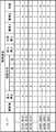
- FIG. 3A is a diagram illustrating an example of map information in which the movement attribute of the obstacle is set as described above.
- (X, Y) is the coordinates of each pixel of the map information.
- caution 1 corresponds to moving at a reduced speed
- caution 2 corresponds to calling attention to the surroundings.
- any one of up, down, left, and right is designated.
- the flag of a certain movement attribute corresponding to each pixel is set to “1”
- the movement attribute is set.
- the flag is set to “0”
- That movement attribute is not set.
- each pixel can have 24-bit or 8-bit information. Therefore, using the information of each pixel, the movement attribute can be set as shown in FIG. 3A. Therefore, in this case, information about a graphic (for example, 24-bit color information, 8-bit grayscale information, etc.) is used as information indicating the movement attribute.
- each movement attribute may correspond to a color, such as “black” for a pixel for which an obstacle is set as the movement attribute, and “red” for a pixel for which entry prohibition is set.
- the correspondence between the movement attribute and the display color may be specified using a color map.
- the operator of the movement attribute setting device 1 inputs an instruction to display the map information of FIG. 3A by operating a mouse or the like.
- the display instruction is received by the receiving unit 14 and passed to the display unit 13 (step S104).
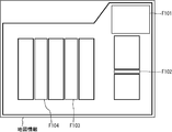
- the display unit 13 reads the map information of FIG. 3A from the map information storage unit 11 and displays it as shown in FIG. 4A (step S105).
- the obstacle graphic is indicated by a thick line, but as described above, a specific color may be assigned to the obstacle graphic.
- FIG. 4A the obstacle graphic is indicated by a thick line, but as described above, a specific color may be assigned to the obstacle graphic.
- the graphic F101 at the upper right of the map information is not a graphic corresponding to an obstacle, but is a graphic indicating a place where articles are not allowed to be left because it is near the entrance to the factory.
- the operator selects the map information figure F101 by operating the mouse and selects the movement attribute “prohibit entry” from the pull-down menu.
- the reception unit 14 receives the selection of the graphic F101 and the movement attribute “prohibition of entry” and passes them to the movement attribute setting unit 15 (steps S106 and S107).
- the movement attribute setting unit 15 changes the movement attribute of the figure F101 from “obstacle” to “entry prohibited” (step S108).
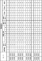
- the movement attribute setting unit 15 moves the movement attributes corresponding to these pixels as shown in FIG. 3B.
- the movement attribute setting unit 15 sets an obstacle flag to “0” and an entry prohibition flag to “1” for each pixel corresponding to the graphic F101.
- a dialog asking whether to continue setting the movement attribute is displayed, and it is assumed that the operator selects “continue” accordingly (step S109).
- the display unit 13 displays the changed map information as shown in FIG. 4B (step S105). In FIG. 4B, it is assumed that the figure F101 is displayed so as to be visually distinguishable from the figure on which the obstacle is set.
- the operator generates a graphic F102 using a tool for generating a rectangular graphic, selects the movement attribute “moving direction (left)”, and sets the graphic F103 and F104 as shown in FIG. 4C. It is assumed that the movement attribute “warning 1” is selected and generated. Then, according to the operation by the operator, the moving body is set to each figure, and the map information is as shown in FIG. 3C (steps S106 to S109).
- FIG. 3C (A301, B301) and the like are pixels corresponding to the graphic F102, and (A401, B401) and the like are pixels corresponding to the graphics F103 and F104.
- the operator inputs a departure place and a destination.
- the starting point or the like may be input by, for example, a coordinate value or may be input by designating a position on the map.
- the starting point and the destination are received by the receiving unit 14 and passed to the movement route acquisition unit 16 (step S110).
- the movement route acquisition unit 16 acquires the movement route using the map information stored in the map information storage unit 11 (step S111).
- the acquired travel route is output by the output unit 17 (step S112).
- the movement route acquisition unit 16 may generate the movement route P1.
- the movement attribute “movement direction (left)” is set at the location of the map F102 of the map information, and the movement route P1 is a route that does not pass through the location because it can only move leftward.
- the movement route acquisition unit 16 may generate the movement route P2.
- the movement attribute “warning 1” is set at the location of the map information F103, the movement attribute of vigilance 1 is added to the range corresponding to that location in the travel route P2. Become.
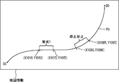
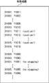
- the travel route P0 from the departure point S0 to the destination G0 of the map information includes a place where the movement attribute “warning 1” is set and a place where the movement attribute “stop prohibition” is set. Is passing. Assume that the coordinates of the start position and the coordinates of the end position of the movement attribute “Warning 1” in the movement path P0 are (X1010, Y1010) and (X1015, Y1015), respectively.
- the coordinates of the start position and the coordinates of the end position of the movement attribute “stop prohibited” in the movement path P0 are (X1090, Y1090) and (X1095, Y1095), respectively.
- the tag corresponding to the warning 1 for the coordinates (X1011, Y1011) to (X1015, Y1015) constituting the travel route. ⁇ Action1> is set, and a tag ⁇ no stopping> corresponding to prohibition of stop is set for the coordinates (X1091, Y1091) to (X1095, Y1095).
- each of the interpolated coordinates has a coordinate closer to the destination. It is assumed that the set movement attribute corresponds. Therefore, for example, in each coordinate interpolated between the coordinates (X1010, Y1010) and (X1011, Y1011), the movement attribute “warning 1” set in (X1011, Y1011) closer to the destination is set. "Corresponds to each. Therefore, when the moving body passes from (X1010, Y1010) to (X1015, Y1015), the speed is reduced. Note that reducing the speed may be, for example, setting a maximum speed value lower than usual.
- FIG. 7 shows a case where the movement path includes a coordinate value and a tag corresponding to the movement attribute. However, the movement path includes direction information indicating the direction of the moving object corresponding to each coordinate value. May be included.
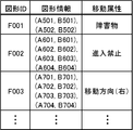
- the map information may be a vector image.
- the map information may be, for example, that shown in FIG. 8A.
- FIG. 8A a graphic ID for identifying a graphic, graphic information, and a movement attribute are associated with each other.
- coordinates constituting the graphic are shown.
- the figure corresponding to the figure ID “F001” is a line segment connecting two points (A501, B501) and (A502, B502), and the movement attribute “obstacle” is set in the line segment.
- the figure corresponding to the figure ID “F002” is a quadrilateral connecting four points (A601, B601), (A602, B602), (A603, B603), (A604, B604), and the quadrilateral has a movement attribute. “No entry” is set.
- a movement attribute may be added and stored in association with each graphic included in the vector image.
- the movement attribute may be set for each type of moving object.
- the type of moving body may be, for example, the type of work performed by the moving body (for example, conveyance, monitoring, cleaning, etc.), or the type of moving system of the moving body (for example, traveling, flying, etc.)
- the size of the moving body for example, large size, medium size, small size, etc.
- the reception unit 14 has a type identifier indicating the type of the moving object corresponding to the movement attribute, together with selection of the graphic included in the map information and the movement attribute. Will be accepted.
- the movement attribute setting unit 15 When the movement attribute is set, the movement attribute setting unit 15 also sets a type identifier corresponding to the movement attribute.
- any setting may be made for the type identifier.
- the map information both the movement attribute and the type identifier may be set for the selected graphic, and the movement attribute may be set for the selected graphic for each type identifier.
- the map information shown in FIG. 3C may exist for each type identifier. In that case, for example, it can be considered that a layer of map information is set for each type of moving object.
- the correspondence between the type identifier and the movement attribute may be set for each graphic.
- the movement attribute “obstacle” is set for all types of moving objects.
- the type identifier “large” is set for the graphic corresponding to the graphic ID “F002”
- the graphic corresponding to the graphic ID “F002” is only for the moving object having the type identifier “large”. Therefore, the movement attribute “prohibition of entry” is set.
- the receiving unit 14 receives the type identifier for identifying the starting point and the destination of the moving body and the type of the moving body. May be.
- the type identifier is a type identifier of a moving object for which a movement route is to be acquired.
- the movement route acquisition unit 16 is a route of a moving body from the departure point received by the reception unit 14 to the destination using the map information in which the movement attribute is set by the movement attribute setting unit 15, and is a figure in the map information. And a movement route that is a route corresponding to the movement attribute corresponding to the type identifier received by the receiving unit 14.
- the movement route acquisition unit 16 acquires a movement route using the movement attribute corresponding to the type identifier received by the reception unit 14. For example, when the movement route is acquired using the map information shown in FIG. 8B and the type identifier “small” is received by the reception unit 14, the movement attribute of the graphic ID “F001” is the movement route. However, the movement attributes of the graphic IDs “F002” and “F003” are not considered in the acquisition of the movement route. On the other hand, when the type identifier “large” is received by the receiving unit 14, the movement attributes of the graphic IDs “F001”, “F002”, and “F003” are all considered in the acquisition of the movement route. As described above, by using the type identifier as well, it becomes possible to perform more detailed setting of the movement attribute, and it is possible to obtain a more appropriate movement route.
- one movement attribute can be set for one graphic included in the map information, but two or more movement attributes may be set for one graphic.
- a stop prohibited movement attribute and a work prohibited movement attribute may be set for a certain figure. In that case, when a movement route for moving the part corresponding to the figure is acquired, a stop prohibition and work prohibition movement attribute is added to the part.
- a movement attribute can be set for a graphic included in map information. Therefore, by acquiring a movement route using such map information, acquisition of a movement route considering the movement attribute can be realized. Therefore, for example, to obtain a movement route that does not pass through the place where entry prohibition is set, or to obtain a movement route that moves in the direction along the movement direction for the place where the movement direction is set, For a portion where stop prohibition is set, a travel route in which information indicating that stop is not set can be acquired. In this way, it is possible to acquire a movement route that allows the moving body to move more appropriately.
- the movement attribute setting device 1 also acquires a movement route has been described, but this need not be the case.
- the acquisition of the movement route may be performed by another device or the like.
- the movement attribute setting device 1 may not include the movement route acquisition unit 16 and the output unit 17.
- the movement attribute setting device 1 may include an output unit that outputs the map information in which the movement attribute is set by the movement attribute setting unit 15. Then, at the output destination, acquisition of a movement route using map information may be performed.
- the output unit may be the same as the output unit 17 except that the output target is different.
- the movement attribute setting unit 15 sets the movement attribute of the obstacle to each figure included in the map information before setting the movement attribute in the map information according to the reception of the movement attribute.
- the movement attribute setting unit 15 sets such an obstacle movement attribute. It does not have to be done.
- the movement attribute setting device 1 includes the map information receiving unit 12
- the map information storage unit 11 is realized by mounting a removable recording medium storing map information on the movement attribute setting device 1
- the movement attribute setting device 1 includes a map information receiving unit. 12 may not be provided.
- the movement attribute setting device 1 is a stand-alone
- the movement attribute setting device 1 may be a stand-alone device or a server device in a server / client system. Good.
- the output unit or the reception unit may receive input or output information via a communication line.
- each process or each function may be realized by centralized processing by a single device or a single system, or may be distributedly processed by a plurality of devices or a plurality of systems. It may be realized by doing.
- the information exchange between the components is performed by one component when, for example, the two components that exchange the information are physically different from each other. It may be performed by outputting information and receiving information by the other component, or when two components that exchange information are physically the same, one component May be performed by moving from the phase of the process corresponding to to the phase of the process corresponding to the other component.
- information related to processing executed by each component for example, information received, acquired, selected, generated, transmitted, or received by each component
- information such as threshold values, mathematical formulas, addresses, and the like used by each constituent element in processing may be temporarily or for a long time held in a recording medium (not shown), even if not specified in the above description.
- the storage of information on the recording medium (not shown) may be performed by each component or a storage unit (not shown).
- reading of information from the recording medium (not shown) may be performed by each component or a reading unit (not shown).
- information used by each component for example, information such as a threshold value, an address, and various setting values used by each component may be changed by the user, Even if it is not specified in the description, the user may be able to change the information as appropriate, or may not be so.
- the change is realized by, for example, a not-shown receiving unit that receives a change instruction from the user and a changing unit (not shown) that changes the information in accordance with the change instruction. May be.
- the change instruction received by the receiving unit (not shown) may be received from an input device, information received via a communication line, or information read from a predetermined recording medium, for example. .
- the two or more components included in the movement attribute setting device 1 when two or more components included in the movement attribute setting device 1 have communication devices, input devices, etc., the two or more components have a physically single device. Or may have separate devices.
- each component may be configured by dedicated hardware, or a component that can be realized by software may be realized by executing a program.
- each component can be realized by a program execution unit such as a CPU reading and executing a software program recorded on a recording medium such as a hard disk or a semiconductor memory.
- the program execution unit may execute the program while accessing the storage unit or the recording medium.
- the program may be executed by being downloaded from a server or the like, or may be executed by reading a program recorded on a predetermined recording medium (for example, an optical disk, a magnetic disk, a semiconductor memory, or the like). Good.
- this program may be used as a program constituting a program product.
- the computer that executes the program may be singular or plural. That is, centralized processing may be performed, or distributed processing may be performed.
- the effect that the movement attribute can be set in the map information can be obtained.
- a device for generating map information used for obtaining the movement route of the moving object etc. Useful.
Landscapes
- Engineering & Computer Science (AREA)
- Radar, Positioning & Navigation (AREA)
- Remote Sensing (AREA)
- Physics & Mathematics (AREA)
- General Physics & Mathematics (AREA)
- Theoretical Computer Science (AREA)
- Automation & Control Theory (AREA)
- Business, Economics & Management (AREA)
- Mathematical Physics (AREA)
- Educational Administration (AREA)
- Educational Technology (AREA)
- Aviation & Aerospace Engineering (AREA)
- Navigation (AREA)
- Instructional Devices (AREA)
Abstract
【課題】地図情報を用いて経路を取得する際に、実空間における移動体の移動領域に関する状況を反映させることができなかった。 【解決手段】移動属性設定装置1は、移動体の移動可能領域を示す地図情報が記憶される地図情報記憶部11と、地図情報を表示する表示部13と、表示された地図情報に含まれる図形の選択と、選択された図形に対応する属性であり、移動体の移動に関する属性である移動属性とを受け付ける受付部14と、地図情報において、受付部14によって選択が受け付けられた図形に、図形に対応する移動属性を設定する移動属性設定部15とを備える。その移動属性の設定された地図情報を用いて移動体の移動経路を取得することにより、進入禁止や移動方向などの実空間における状況を、移動経路の取得に反映させることができる。その結果、移動体の適切な移動を実現することができる。
Description
本発明は、移動体の移動可能領域を示す地図情報に対して移動体の移動に関する属性を設定する移動属性設定装置に関する。
従来、障害物の設定されている地図情報を用いて、移動体の出発地から目的地までの経路を探索することが行われていた。その探索手法の一つとして、例えば、RRT(Rapidly-exploring Random Tree)が知られている(例えば、非特許文献1参照)。
S. M. LaValle,"Rapidly-exploring random trees: A new tool for path planning",TR 98-11,Computer Science Dept.,Iowa State University,1998
しかしながら、従来の経路探索に用いられる地図情報においては、壁などの障害物の情報を設定することしかできなかった。そのため、その地図情報を用いた経路探索によって得られた経路に沿って移動体を実際に移動させた場合には、不適切な移動となることもあった。具体的には、人通りの多い領域などのように移動体が進入しないほうがよい領域があったとしても、その領域を含む経路が生成される可能性があった。また、1個の移動体が通過できる程度の幅しかない細い通路が存在した場合に、2個の移動体について、その通路をそれぞれ反対方向に移動する経路が生成される可能性があった。そして、そのような経路に沿って2個の移動体が移動した場合に、その通路において両移動体が向かい合った状態で停止してしまう可能性もあった。このように、地図情報を用いた経路の取得において、実空間における移動体の移動領域に関する状況を反映させることができないという問題があった。
本発明は、上記課題を解決するためになされたものであり、経路の取得に用いられる地図情報に対して、適切な経路を取得できるようにするための情報を設定できる装置を提供することを目的とする。
上記目的を達成するため、本発明による移動属性設定装置は、移動体の移動可能領域を示す地図情報が記憶される地図情報記憶部と、地図情報を表示する表示部と、表示された地図情報に含まれる図形の選択と、選択された図形に対応する属性であり、移動体の移動に関する属性である移動属性とを受け付ける受付部と、地図情報において、受付部によって選択が受け付けられた図形に、図形に対応する移動属性を設定する移動属性設定部と、を備えたものである。
このような構成により、地図情報に含まれる図形に、移動体の移動に関する移動属性を設定することができる。したがって、経路の取得にその地図情報が用いられることによって、移動属性を考慮した経路が取得されることになり、より適切な経路の取得を実現することができる。
このような構成により、地図情報に含まれる図形に、移動体の移動に関する移動属性を設定することができる。したがって、経路の取得にその地図情報が用いられることによって、移動属性を考慮した経路が取得されることになり、より適切な経路の取得を実現することができる。
また、本発明による移動属性設定装置では、移動属性は、障害物、進入禁止、移動方向、停止禁止、作業禁止、警戒、待避から選ばれる少なくとも1種であってもよい。
このような構成により、例えば、地図情報において、移動体が進入しない領域を設定したり、移動体の移動方向を制限したりすることができる。その結果、例えば、経路の取得にそのような地図情報が用いられることにより、人通りの多い領域を通過しない経路の取得や、細い通路については一方向にしか通過しない経路の取得等を実現することができるようになる。
このような構成により、例えば、地図情報において、移動体が進入しない領域を設定したり、移動体の移動方向を制限したりすることができる。その結果、例えば、経路の取得にそのような地図情報が用いられることにより、人通りの多い領域を通過しない経路の取得や、細い通路については一方向にしか通過しない経路の取得等を実現することができるようになる。
また、本発明による移動属性設定装置では、移動属性設定部は、受付部による移動属性の受け付けに応じた地図情報における移動属性の設定を行う前に、地図情報に含まれる各図形に障害物の移動属性を設定してもよい。
このような構成により、地図情報に含まれる壁などを、自動的に障害物に設定することができ、操作者等が手作業で障害物の設定等を行う必要がなくなり、操作者等の利便性を向上することができる。
このような構成により、地図情報に含まれる壁などを、自動的に障害物に設定することができ、操作者等が手作業で障害物の設定等を行う必要がなくなり、操作者等の利便性を向上することができる。
また、本発明による移動属性設定装置では、受付部は、移動属性に対応する移動体の種類を示す種類識別子をも受け付けるものであり、移動属性設定部は、移動属性を設定する際に、移動属性に対応する種類識別子をも設定してもよい。
このような構成により、移動体の種類ごとに異なる移動属性を設定することができるようになる。例えば、移動体の大きさや、移動体が行う作業の種類等に応じて、異なる移動属性を設定することができるようになる。
このような構成により、移動体の種類ごとに異なる移動属性を設定することができるようになる。例えば、移動体の大きさや、移動体が行う作業の種類等に応じて、異なる移動属性を設定することができるようになる。
また、本発明による移動属性設定装置では、受付部は、移動体の出発地及び目的地をも受け付けるものであり、移動属性設定部によって移動属性の設定された地図情報を用いて、受付部によって受け付けられた出発地から目的地までの移動体の経路であり、地図情報における図形ごとの移動属性に応じた経路である移動経路を取得する移動経路取得部と、移動経路取得部によって取得された移動経路を出力する出力部と、をさらに備えてもよい。
このような構成により、地図情報に設定された移動属性を考慮した移動経路の取得を行うことができる。その結果、移動属性を考慮しなかった場合よりも、適切な移動経路を取得することができるようになる。
このような構成により、地図情報に設定された移動属性を考慮した移動経路の取得を行うことができる。その結果、移動属性を考慮しなかった場合よりも、適切な移動経路を取得することができるようになる。
また、本発明による移動属性設定装置では、受付部は、移動体の出発地及び目的地並びに移動体の種類を識別する種類識別子をも受け付けるものであり、移動属性設定部によって移動属性の設定された地図情報を用いて、受付部によって受け付けられた出発地から目的地までの移動体の経路であり、地図情報における図形ごとの移動属性であって、受付部によって受け付けられた種類識別子に対応する移動属性に応じた経路である移動経路を取得する移動経路取得部と、移動経路取得部によって取得された移動経路を出力する出力部と、をさらに備えてもよい。
このような構成により、地図情報に設定された移動属性を考慮した移動経路の取得を、移動体の種類に応じて行うことができる。その結果、移動属性を考慮しなかった場合よりも、適切な移動経路を取得することができ、また、移動体の種類に応じた適切な移動経路を取得することもできるようになる。
このような構成により、地図情報に設定された移動属性を考慮した移動経路の取得を、移動体の種類に応じて行うことができる。その結果、移動属性を考慮しなかった場合よりも、適切な移動経路を取得することができ、また、移動体の種類に応じた適切な移動経路を取得することもできるようになる。
本発明による移動属性設定装置によれば、地図情報に含まれる図形に、移動体の移動に関する移動属性を設定することができるようになる。その結果、その地図情報に設定された移動属性を考慮した経路を取得することによって、より適切な経路の取得を実現できるようになる。
以下、本発明による移動属性設定装置について、実施の形態を用いて説明する。なお、以下の実施の形態において、同じ符号を付した構成要素及びステップは同一または相当するものであり、再度の説明を省略することがある。本実施の形態による移動属性設定装置は、移動体の移動可能領域を示す地図情報に含まれる図形に対して、進入禁止等の移動属性を設定するものである。
図1は、本実施の形態による移動属性設定装置1の構成を示すブロック図である。本実施の形態による移動属性設定装置1は、地図情報記憶部11と、地図情報受付部12と、表示部13と、受付部14と、移動属性設定部15と、移動経路取得部16と、出力部17とを備える。
地図情報記憶部11では、移動体の移動可能領域を示す地図情報が記憶される。この地図情報は、移動経路取得部16による移動体の移動経路の取得に用いられるものである。したがって、地図情報によって、移動体の移動可能領域が示されることになる。すなわち、地図情報において、移動体が移動できる箇所と、移動できない箇所とが区別可能になっているものとする。その地図情報は、例えば、移動体の移動領域における障害物の領域を示す情報であってもよい。障害物の領域は、例えば、障害物の位置と大きさとによって示されてもよく、障害物の境界線や輪郭線によって示されてもよい。障害物とは、移動体が移動する領域に継続的または一時的に存在する、移動体の移動の障害となるものであり、例えば、柱や壁、載置物等であってもよい。その地図情報は、例えば、柱や壁等を示す地図の情報であると考えてもよい。例えば、移動経路取得部16によって状態空間探索法による移動経路の取得が行われる場合には、地図情報は、そのように移動体の移動可能領域を示すものであればよいことになる。一方、例えば、移動経路取得部16によってノード探索法による経路の演算が行われる場合には、地図情報には、ノード探索で用いられるノードやリンクも含まれていることが好適である。ノード探索で用いられる地図情報は、例えば、カーナビゲーションで用いられるKIWIフォーマットの地図情報であってもよく、ノード探索を行うことができる他のフォーマットの地図情報であってもよい。また、地図情報に含まれる図形には、移動体の移動に関する属性である移動属性を設定することができるようになっているものとする。その移動属性の設定については後記する。また、地図情報は、例えば、ラスタ画像の情報であってもよく、ベクタ画像の情報であってもよい。本実施の形態では、地図情報がラスタ画像の情報である場合について主に説明し、地図情報がベクタ画像の情報である場合については後記する。また、地図情報は、例えば、建物内などの屋内の地図情報であってもよく、屋外の地図情報であってもよい。また、屋内の地図情報は、例えば、工場等の地図情報であってもよい。また、地図情報は、例えば、監視対象の領域や清掃対象の領域の地図情報であってもよい。
移動体は、例えば、走行する走行体や、飛行する飛行体であってもよい。また、移動体は、例えば、台車であってもよく、ロボットであってもよい。ロボットは、例えば、エンターテインメントロボット、監視ロボット、搬送ロボット、清掃ロボット等であってもよい。また、飛行体は、例えば、回転翼機(例えば、ヘリコプターや、3個以上の回転翼を有するマルチコプター等)、飛行機、飛行船等であってもよい。マルチコプターは、例えば、4個の回転翼を有するクワッドロータであってもよい。本実施の形態では、移動体が搬送台車である場合について主に説明する。なお、移動体が走行体である場合には、地図情報は、例えば、2次元平面に関する地図情報であってもよい。一方、移動体が飛行体である場合には、地図情報は、例えば、3次元空間に関する地図情報であってもよい。
地図情報記憶部11での記憶は、RAM等における一時的な記憶でもよく、または、長期的な記憶でもよい。地図情報記憶部11は、所定の記録媒体(例えば、半導体メモリや磁気ディスク、光ディスクなど)によって実現されうる。なお、本実施の形態では、地図情報が地図情報受付部12によって地図情報記憶部11に蓄積される場合について説明する。
地図情報受付部12は、地図情報を受け付け、その受け付けた地図情報を地図情報記憶部11に蓄積する。地図情報受付部12が受け付ける地図情報は、例えば、CADデータ等がラスタ画像やベクタ画像などの地図情報に変換されたものであってもよく、手作業で作成されたものであってもよく、その他の方法によって用意されたものであってもよい。地図情報受付部12によって受け付けられた地図情報に含まれる各図形は、障害物に対応していてもよく、障害物以外のもの(例えば、物品の放置禁止区域や、材料や製品、使用済パレット等の置き場所など)に対応していてもよい。地図情報受付部12は、例えば、有線または無線の通信回線を介して送信された情報を受信してもよく、所定の記録媒体(例えば、光ディスクや磁気ディスク、半導体メモリなど)から読み出された情報を受け付けてもよい。なお、地図情報受付部12は、受け付けを行うためのデバイス(例えば、モデムやネットワークカードなど)を含んでもよく、または含まなくてもよい。また、地図情報受付部12は、ハードウェアによって実現されてもよく、または所定のデバイスを駆動するドライバ等のソフトウェアによって実現されてもよい。
表示部13は、地図情報記憶部11で記憶されている地図情報を表示する。なお、表示部13は、地図情報に含まれる図形を、その図形に対して設定されている移動属性ごとに視覚的に区別可能なように表示してもよい。視覚的に区別可能なように表示するとは、例えば、異なる色で表示することであってもよく、異なる種類の線(例えば、実線、波線、破線、一点鎖線等)や異なる種類の網掛け等で表示することであってもよい。また、表示部13は、地図情報以外の表示を行ってもよい。例えば、移動属性の設定等に用いられるメニューやボタン等を表示してもよい。また、表示部13は、表示を行う表示デバイス(例えば、液晶ディスプレイや有機ELディスプレイなど)を含んでもよく、または含まなくてもよい。また、地図情報等の表示は、移動属性設定装置1と別の装置においてなされてもよい。その場合には、表示部13は、移動属性設定装置1の外部に、地図情報等の表示に用いられる情報を出力するものであってもよい。すなわち、表示部13による地図情報等の表示は、地図情報等の表示に用いられる情報の出力を含んでいると考えてもよい。また、表示部13は、ハードウェアによって実現されてもよく、または表示デバイスを駆動するドライバ等のソフトウェアによって実現されてもよい。
受付部14は、表示された地図情報に含まれる図形の選択と、その選択された図形に対応する移動属性とを受け付ける。地図情報に含まれる図形は、例えば、地図情報に含まれる既存の図形であってもよく、図形の選択時に生成された図形であってもよい。後者の場合には、例えば、生成された図形が選択された図形とみなされてもよい。既存の図形の選択は、例えば、既存の図形をマウスでクリックしたり、既存の図形の位置や範囲をマウスでドラッグしたりすることによって行われてもよい。また、1個の図形が選択されてもよく、または、2個以上の図形が一括して選択されてもよい。図形の選択は、例えば、公知の画像処理ソフトにおける図形の選択と同様に行われてもよい。選択の対象となる図形は、例えば、点状の図形、線状の図形、面状の図形、及びそれらの組み合わせから選ばれる少なくとも1種であってもよい。線状の図形は、例えば、線分等のように直線状の図形であってもよく、円弧等のように曲線状の図形であってもよい。面状の図形は、例えば、多角形状の図形や円形状の図形、楕円形状の図形、その他の2次元の広がりを持った図形であってもよい。なお、ある移動属性の設定されている面状の図形が、輪郭で構成される図形である場合、すなわち、塗りつぶされていない図形である場合に、その図形の輪郭の内部についても、その移動属性が設定されていると考えてもよく、または、そうでなくてもよい。前者の場合には、輪郭で構成される面状の図形に設定されている移動属性の範囲と、同じ位置に存在する、塗りつぶされている面状の図形に設定されている移動属性の範囲とは同じになり、後者の場合には、両範囲は異なることになる。移動属性は、選択された図形に対応する属性であり、移動体の移動に関する属性である。受付部14によって受け付けられた移動属性は、移動属性設定部15によって、地図情報における選択された図形に設定されることになる。移動属性は、例えば、障害物、進入禁止、移動方向、停止禁止、作業禁止、警戒、待避から選ばれる少なくとも1種であってもよい。各移動属性については後記する。移動属性は、例えば、移動経路の探索に用いられる属性であってもよい。その場合には、地図情報の図形に設定されている移動属性に応じて、取得される移動経路の通過地点が決定されることになる。例えば、移動属性が、進入禁止である場合には、その進入禁止が設定されている図形の位置を通過しないように移動経路が取得されることになる。また、例えば、移動経路が移動方向である場合には、特定の移動方向が設定されている図形の位置を移動経路が通過するときには、その特定の移動方向となるように移動経路が取得されることになる。また、移動属性は、例えば、移動経路に付加される属性であってもよい。その場合には、地図情報の図形に設定されている移動属性に応じて、取得される移動経路に付加される情報が決定されることになる。例えば、停止禁止の移動属性が設定されている領域を通過する移動経路が取得される場合には、その領域に対応する移動経路の範囲において、移動体の停止が禁止される旨が移動経路に含まれることになる。そして、その移動経路に応じて移動体が移動する際には、移動体の停止が禁止されている範囲においては、移動体が停止されないように制御されるものとする。このように、移動属性は、移動経路の取得時に用いられるルールや、移動経路に沿った移動体の移動時に用いられるルールであると考えてもよい。
受付部14は、移動体の出発地及び目的地をも受け付けてもよい。その移動体の出発地及び目的地は、移動経路取得部16における移動経路の取得に用いられてもよい。移動体の出発地は、例えば、移動体の現在位置であってもよい。また、受付部14が出発地や目的地を受け付ける方法は問わない。受付部14が受け付ける出発地等は、例えば、出発地等を示す座標(例えば、緯度・経度や、移動体の移動領域の座標系における座標値等)によって示されてもよく、地図上で指定されてもよい。後者の場合には、地図上において、出発地や目的地の位置の指定が受け付けられてもよい。
また、受付部14は、その他の受け付けを行ってもよい。例えば、受付部14は、地図情報の表示の指示等を受け付けてもよい。受付部14は、例えば、入力デバイス(例えば、キーボードやマウス、タッチパネルなど)から入力された情報を受け付けてもよく、有線または無線の通信回線を介して送信された情報を受信してもよく、所定の記録媒体(例えば、光ディスクや磁気ディスク、半導体メモリなど)から読み出された情報を受け付けてもよい。なお、受付部14は、受け付けを行うためのデバイス(例えば、入力デバイスやネットワークカードなど)を含んでもよく、または含まなくてもよい。また、受付部14は、ハードウェアによって実現されてもよく、または所定のデバイスを駆動するドライバ等のソフトウェアによって実現されてもよい。
移動属性設定部15は、図形の選択と、その図形に対応する移動属性とが受付部14によって受け付けられた場合に、地図情報において、その選択された図形に、その図形に対応する移動属性を設定する。選択された図形とは、受付部14によって選択が受け付けられた図形のことである。なお、地図情報において、その地図情報に含まれる図形と、その図形に対応する移動属性との対応関係が分かるのであれば、図形に対する移動属性の設定方法は問わない。例えば、移動属性設定部15は、地図情報において、図形に対応付けて移動属性を追加してもよく、図形の識別子と移動属性とを対応付けて蓄積してもよく、図形に関する情報(例えば、色やグレースケールの情報等)を、移動属性を示す情報として用いてもよく、その他の方法によって移動属性の設定を行ってもよい。移動属性設定部15による図形に対する具体的な移動属性の設定方法については後記する。また、2個以上の図形が一括して選択された場合には、移動属性設定部15は、その2個以上の各図形に対して、受け付けられた移動属性を設定してもよい。また、移動属性設定部15は、受付部14による移動属性の受け付けに応じた地図情報における移動属性の設定を行う前に、地図情報に含まれる各図形に障害物の移動属性を設定してもよい。例えば、地図情報受付部12によって受け付けられた地図情報が地図情報記憶部11に蓄積された直後に、地図情報に含まれる各図形に障害物の移動属性が設定されてもよい。このようにすることで、地図情報に含まれる初期の図形をすべて障害物にすることができる。
移動経路取得部16は、移動属性設定部15によって移動属性の設定された地図情報を用いて、受付部14によって受け付けられた出発地から目的地までの移動体の経路であり、地図情報における図形ごとの移動属性に応じた経路である移動経路を取得する。その移動経路は、あらかじめ設定されている経路ではなく、演算された経路である。移動属性に応じた移動経路を取得するとは、例えば、移動属性が移動経路の探索に用いられる属性である場合に、移動経路取得部16が、その移動属性を用いて、移動経路の通過地点を決定することであってもよく、移動属性が移動経路に付加される属性である場合に、移動経路取得部16が、その移動属性に応じた情報の付加された移動経路を取得することであってもよい。移動経路取得部16は、例えば、状態空間探索法によって移動経路を探索してもよく、または、ノード探索法によって移動経路を探索してもよい。状態空間探索法によって経路探索を行う場合には、移動経路取得部16は、移動体の移動可能領域を示す地図情報を用いて、例えば、RRT、ラプラスポテンシャル法、熱ポテンシャル法等の公知のアルゴリズムを用いて経路の探索を行ってもよい。状態空間探索法では、あらかじめノード等の設定されていない空間において、障害物を回避するように移動経路が取得されることになる。なお、RRTについては、例えば、上記非特許文献1を参照されたい。また、RRTによって経路探索が行われる場合には、地図情報がラスタ画像であるほうが、経路探索の負荷がより軽くなる。
ノード探索法によって経路探索を行う場合には、移動経路取得部16は、あらかじめノードやリンクの設定されている地図情報を用いて、例えば、ダイクストラ法、A*アルゴリズム、ベルマン-フォード法、ワーシャル-フロイド法等の公知のアルゴリズムを用いて経路の探索を行ってもよい。ノード探索法では、あらかじめ定められたノードをつなげた移動経路が取得されることになる。
ノード探索法によって経路探索を行う場合には、移動経路取得部16は、あらかじめノードやリンクの設定されている地図情報を用いて、例えば、ダイクストラ法、A*アルゴリズム、ベルマン-フォード法、ワーシャル-フロイド法等の公知のアルゴリズムを用いて経路の探索を行ってもよい。ノード探索法では、あらかじめ定められたノードをつなげた移動経路が取得されることになる。
また、移動経路取得部16は、移動体の移動経路を取得する際に、移動体の方向を示す方向情報を含めて移動経路を取得してもよい。その方向情報は、例えば、経路上の位置に対応する情報であり、その位置における移動体の方向を示す情報であってもよい。すなわち、移動経路上の各位置について、方向情報が設定されてもよい。その方向情報は、例えば、方位角の情報であってもよく、方位角と仰俯角との情報であってもよく、ロール・ピッチ・ヨー角やオイラー角の情報であってもよい。すなわち、方向情報は、2次元平面における方向を示す情報であってもよく、3次元空間における方向を示す情報であってもよく、3次元空間(ワールド座標系)における3次元空間(移動体のローカル座標系)の方向を示す情報であってもよい。例えば、移動経路取得部16は、移動体の前方が進行方向を向くように方向情報を含む移動経路を取得してもよい。また、例えば、移動体が監視ロボットである場合には、移動経路取得部16は、移動体の有するカメラ等が監視対象を向くように方向情報を含む移動経路を取得してもよい。
また、出発地と目的地が地図上における指定によって受け付けられた場合には、移動経路取得部16は、その指定された地図上の位置を、その位置に対応する座標に変換して用いてもよい。
また、移動経路取得部16は、例えば、移動経路を演算することによって取得してもよく、または、経路を演算するサーバ等に移動経路の演算の指示を送信し、その送信に応じて移動経路の演算結果を受信することによって移動経路を取得してもよい。本実施の形態では、前者の場合、すなわち移動経路取得部16によって移動経路の生成が行われる場合について主に説明する。
また、出発地と目的地が地図上における指定によって受け付けられた場合には、移動経路取得部16は、その指定された地図上の位置を、その位置に対応する座標に変換して用いてもよい。
また、移動経路取得部16は、例えば、移動経路を演算することによって取得してもよく、または、経路を演算するサーバ等に移動経路の演算の指示を送信し、その送信に応じて移動経路の演算結果を受信することによって移動経路を取得してもよい。本実施の形態では、前者の場合、すなわち移動経路取得部16によって移動経路の生成が行われる場合について主に説明する。
出力部17は、移動経路取得部16によって取得された移動経路を出力する。なお、その移動経路の出力の際に、出力部17は、その移動経路の取得に用いられた地図情報も一緒に出力してもよい。そのようにして出力された地図情報は、例えば、移動体が移動経路に沿った移動を行う際に、既存の障害物と新たな障害物とを判別するためなどに用いられてもよい。ここで、この出力は、例えば、表示デバイス(例えば、液晶ディスプレイや有機ELディスプレイなど)への表示でもよく、所定の機器への通信回線を介した送信でもよく、プリンタによる印刷でもよく、記録媒体への蓄積でもよく、他の構成要素への引き渡しでもよい。移動体に移動経路を渡す観点からは、出力は、送信や蓄積、他の構成要素への引き渡し等であることが好適である。なお、出力部17は、出力を行うデバイス(例えば、表示デバイスや送信デバイスなど)を含んでもよく、または含まなくてもよい。また、出力部17は、ハードウェアによって実現されてもよく、または、それらのデバイスを駆動するドライバ等のソフトウェアによって実現されてもよい。
ここで、具体的な移動属性、及びその移動属性に応じた移動経路の取得について説明する。
(1)障害物
障害物の移動属性が設定された図形は、地図情報において、移動体の移動できない箇所を示すことになる。例えば、移動体の移動領域に存在する壁や柱、載置物等が障害物に設定されてもよい。障害物の移動属性は、移動経路の探索に用いられる属性である。したがって、移動経路が取得される際には、その障害物の位置を通過しない移動経路が取得されることになる。具体的には、状態空間探索法による移動経路の取得が行われる場合には、障害物の移動属性が設定された図形の範囲には入らないように経路が取得されることになる。また、ノード探索法による移動経路の取得が行われる場合には、障害物の移動属性が設定された図形の範囲のノードは選択されないように経路が取得されることになる。
(1)障害物
障害物の移動属性が設定された図形は、地図情報において、移動体の移動できない箇所を示すことになる。例えば、移動体の移動領域に存在する壁や柱、載置物等が障害物に設定されてもよい。障害物の移動属性は、移動経路の探索に用いられる属性である。したがって、移動経路が取得される際には、その障害物の位置を通過しない移動経路が取得されることになる。具体的には、状態空間探索法による移動経路の取得が行われる場合には、障害物の移動属性が設定された図形の範囲には入らないように経路が取得されることになる。また、ノード探索法による移動経路の取得が行われる場合には、障害物の移動属性が設定された図形の範囲のノードは選択されないように経路が取得されることになる。
(2)進入禁止
進入禁止の移動属性が設定された図形は、地図情報において、移動体が進入できない箇所を示すことになる。例えば、地図情報において、移動体に進入して欲しくない箇所に対応する図形に、進入禁止の移動属性が設定されてもよい。例えば、移動体が通過するのに不適切と考えられる箇所、例えば、ドアの開閉時にドアが通過する箇所に進入禁止が設定されてもよく、多くの人が通る箇所に進入禁止が設定されてもよい。進入禁止の移動属性は、移動経路の探索に用いられる属性である。したがって、移動経路が取得される際には、障害物の場合と同様に、その進入禁止の位置を通過しない移動経路が取得されることになる。なお、障害物が存在しない箇所であっても、進入禁止に設定することによって、障害物が存在する場合と同様の効果が得られることになる。
進入禁止の移動属性が設定された図形は、地図情報において、移動体が進入できない箇所を示すことになる。例えば、地図情報において、移動体に進入して欲しくない箇所に対応する図形に、進入禁止の移動属性が設定されてもよい。例えば、移動体が通過するのに不適切と考えられる箇所、例えば、ドアの開閉時にドアが通過する箇所に進入禁止が設定されてもよく、多くの人が通る箇所に進入禁止が設定されてもよい。進入禁止の移動属性は、移動経路の探索に用いられる属性である。したがって、移動経路が取得される際には、障害物の場合と同様に、その進入禁止の位置を通過しない移動経路が取得されることになる。なお、障害物が存在しない箇所であっても、進入禁止に設定することによって、障害物が存在する場合と同様の効果が得られることになる。
(3)移動方向
移動方向の移動属性が設定された図形は、地図情報において、移動体が移動可能な方向を示すことになる。その移動属性は、その方向を示す情報を含んでいてもよい。方向は、例えば、地図情報に対して、上、下、左、右のように示されてもよく、北、南、西、東のように示されてもよく、方位角などの角度で示されてもよい。例えば、地図情報において、移動体が特定の方向にのみ移動して欲しい箇所に対応する図形に、その特定の方向に応じた移動方向が設定されてもよい。例えば、1個の移動体のみが通過できる程度の幅しかない通路が存在した場合に、その通路の位置の図形に、一方の方向を示す移動方向の移動属性が設定されてもよい。移動方向の移動属性は、移動経路の探索に用いられる属性である。したがって、移動方向に対応する図形の箇所を通過する移動経路が取得される際には、その移動方向によって示される方向に移動する移動経路のみが取得されることになる。具体的には、状態空間探索法による移動経路の取得が行われる場合には、移動方向の移動属性が設定された図形の範囲においては、設定されている移動方向に延びる経路のみが取得され、そうでない経路は取得されないことになる。また、ノード探索法による移動経路の取得が行われる場合には、移動方向の移動属性が設定された図形の範囲のノードの選択においては、設定されている移動方向に沿ったノード間の移動に応じた経路のみが取得され、そうでない経路は取得されないことになる。なお、移動方向によって示される方向と、その移動方向の移動属性が設定された図形の範囲において取得される移動経路の向きとは、厳密に同じであってもよく、または、ある程度の許容範囲があってもよい。後者の場合には、例えば、移動方向が「上」を示していても、上向きから所定の角度の範囲内(例えば、±30°の範囲内など)の向きの経路が、その移動方向の移動属性が設定されている図形の範囲において取得されてもよい。
移動方向の移動属性が設定された図形は、地図情報において、移動体が移動可能な方向を示すことになる。その移動属性は、その方向を示す情報を含んでいてもよい。方向は、例えば、地図情報に対して、上、下、左、右のように示されてもよく、北、南、西、東のように示されてもよく、方位角などの角度で示されてもよい。例えば、地図情報において、移動体が特定の方向にのみ移動して欲しい箇所に対応する図形に、その特定の方向に応じた移動方向が設定されてもよい。例えば、1個の移動体のみが通過できる程度の幅しかない通路が存在した場合に、その通路の位置の図形に、一方の方向を示す移動方向の移動属性が設定されてもよい。移動方向の移動属性は、移動経路の探索に用いられる属性である。したがって、移動方向に対応する図形の箇所を通過する移動経路が取得される際には、その移動方向によって示される方向に移動する移動経路のみが取得されることになる。具体的には、状態空間探索法による移動経路の取得が行われる場合には、移動方向の移動属性が設定された図形の範囲においては、設定されている移動方向に延びる経路のみが取得され、そうでない経路は取得されないことになる。また、ノード探索法による移動経路の取得が行われる場合には、移動方向の移動属性が設定された図形の範囲のノードの選択においては、設定されている移動方向に沿ったノード間の移動に応じた経路のみが取得され、そうでない経路は取得されないことになる。なお、移動方向によって示される方向と、その移動方向の移動属性が設定された図形の範囲において取得される移動経路の向きとは、厳密に同じであってもよく、または、ある程度の許容範囲があってもよい。後者の場合には、例えば、移動方向が「上」を示していても、上向きから所定の角度の範囲内(例えば、±30°の範囲内など)の向きの経路が、その移動方向の移動属性が設定されている図形の範囲において取得されてもよい。
(4)停止禁止
停止禁止の移動属性が設定された図形は、地図情報において、移動体が停止できない箇所を示すことになる。例えば、消火栓や火災報知器等の緊急設備の周囲の箇所に対応する図形に、停止禁止の移動属性が設定されてもよい。停止禁止の移動属性は、移動経路に付加される属性である。したがって、停止禁止に対応する図形の箇所を通過する移動経路が取得される際には、停止禁止の箇所の分かる移動経路が取得されることになる。すなわち、取得された移動経路において、停止禁止の箇所の開始位置と終了位置とが分かるようになる。
停止禁止の移動属性が設定された図形は、地図情報において、移動体が停止できない箇所を示すことになる。例えば、消火栓や火災報知器等の緊急設備の周囲の箇所に対応する図形に、停止禁止の移動属性が設定されてもよい。停止禁止の移動属性は、移動経路に付加される属性である。したがって、停止禁止に対応する図形の箇所を通過する移動経路が取得される際には、停止禁止の箇所の分かる移動経路が取得されることになる。すなわち、取得された移動経路において、停止禁止の箇所の開始位置と終了位置とが分かるようになる。
(5)作業禁止
作業禁止の移動属性が設定された図形は、地図情報において、移動体が作業を行うことができない箇所を示すことになる。移動体の作業とは、例えば、搬送ロボットについては、搬送対象の積み降ろしであってもよく、監視ロボットについては、周囲の撮影や撮影画像の解析であってもよく、清掃ロボットについては、清掃であってもよく、エンターテインメントロボットについては、人との対話などであってもよい。例えば、移動体が監視ロボットである場合に、撮影等の行われたくない箇所に対応する図形に、作業禁止の移動属性が設定されてもよい。作業禁止の移動属性は、移動経路に付加される属性である。したがって、作業禁止に対応する図形の箇所を通過する移動経路が取得される際には、作業禁止の箇所の分かる移動経路が取得されることになる。すなわち、取得された移動経路において、作業禁止の箇所の開始位置と終了位置とが分かるようになる。
作業禁止の移動属性が設定された図形は、地図情報において、移動体が作業を行うことができない箇所を示すことになる。移動体の作業とは、例えば、搬送ロボットについては、搬送対象の積み降ろしであってもよく、監視ロボットについては、周囲の撮影や撮影画像の解析であってもよく、清掃ロボットについては、清掃であってもよく、エンターテインメントロボットについては、人との対話などであってもよい。例えば、移動体が監視ロボットである場合に、撮影等の行われたくない箇所に対応する図形に、作業禁止の移動属性が設定されてもよい。作業禁止の移動属性は、移動経路に付加される属性である。したがって、作業禁止に対応する図形の箇所を通過する移動経路が取得される際には、作業禁止の箇所の分かる移動経路が取得されることになる。すなわち、取得された移動経路において、作業禁止の箇所の開始位置と終了位置とが分かるようになる。
(6)警戒
警戒の移動属性が設定された図形は、地図情報において、移動体が警戒しながら移動する箇所を示すことになる。警戒は、例えば、速度を落として移動することであってもよく、赤色灯の点灯や特異な音出力等によって、周囲への注意喚起を行うことであってもよい。例えば、人通りの多い箇所に対応する図形に、警戒の移動属性が設定されてもよい。移動体と人との接触を回避するためである。警戒の移動属性は、移動経路に付加される属性である。したがって、警戒に対応する図形の箇所を通過する移動経路が取得される際には、警戒の箇所の分かる移動経路が取得されることになる。すなわち、取得された移動経路において、警戒の箇所の開始位置と終了位置とが分かるようになる。
警戒の移動属性が設定された図形は、地図情報において、移動体が警戒しながら移動する箇所を示すことになる。警戒は、例えば、速度を落として移動することであってもよく、赤色灯の点灯や特異な音出力等によって、周囲への注意喚起を行うことであってもよい。例えば、人通りの多い箇所に対応する図形に、警戒の移動属性が設定されてもよい。移動体と人との接触を回避するためである。警戒の移動属性は、移動経路に付加される属性である。したがって、警戒に対応する図形の箇所を通過する移動経路が取得される際には、警戒の箇所の分かる移動経路が取得されることになる。すなわち、取得された移動経路において、警戒の箇所の開始位置と終了位置とが分かるようになる。
(7)待避
待避の移動属性が設定された図形は、移動体が周囲に存在する別の移動体を検知した場合に、その別の移動体が行き過ぎるまで待避する箇所を、地図情報において示すことになる。例えば、1個の移動体のみが通過できる程度の幅しかない通路が存在する場合に、その通路への出入り口付近の箇所に対応する図形に、待避の移動属性が設定されてもよい。具体的には、図5で示されるように、破線の矩形図形の領域に対して、待避の移動属性が設定されていてもよい。その場合には、例えば、移動体501が、移動経路に沿った移動を行っている際に、待避の移動属性が設定されている領域内において、他の移動体502の存在を検知した時には、その移動体502が行き過ぎるまで、その位置で待ち、移動体502が行き過ぎた後に、移動経路に沿った移動を再開してもよい。待避の移動属性は、移動経路に付加される属性である。したがって、待避に対応する図形の箇所を通過する移動経路が取得される際には、待避の箇所の分かる移動経路が取得されることになる。すなわち、取得された移動経路において、待避の箇所の開始位置と終了位置とが分かるようになる。
待避の移動属性が設定された図形は、移動体が周囲に存在する別の移動体を検知した場合に、その別の移動体が行き過ぎるまで待避する箇所を、地図情報において示すことになる。例えば、1個の移動体のみが通過できる程度の幅しかない通路が存在する場合に、その通路への出入り口付近の箇所に対応する図形に、待避の移動属性が設定されてもよい。具体的には、図5で示されるように、破線の矩形図形の領域に対して、待避の移動属性が設定されていてもよい。その場合には、例えば、移動体501が、移動経路に沿った移動を行っている際に、待避の移動属性が設定されている領域内において、他の移動体502の存在を検知した時には、その移動体502が行き過ぎるまで、その位置で待ち、移動体502が行き過ぎた後に、移動経路に沿った移動を再開してもよい。待避の移動属性は、移動経路に付加される属性である。したがって、待避に対応する図形の箇所を通過する移動経路が取得される際には、待避の箇所の分かる移動経路が取得されることになる。すなわち、取得された移動経路において、待避の箇所の開始位置と終了位置とが分かるようになる。
上記の各移動属性は、条件付きのものであってもよい。すなわち、ある条件が満たされた場合に、移動属性が意味を有することになってもよい。その条件は、例えば、移動体に関する条件であってもよく、移動体以外の条件であってもよい。具体的には、移動体に関する条件は、例えば、移動体のリフタが上がっていること、移動体のリフタが下がっていること、移動体のマニピュレータが基準となる位置に存在することなどであってもよい。より具体的には、条件付き移動属性は、リフタが上がっている場合には進入禁止というものであってもよい。また、進入禁止、移動方向の移動属性が条件付きである場合に、例えば、条件が満たされる場合にのみ、それらの移動属性が移動経路の探索に用いられてもよい。また、停止禁止、作業禁止、警戒、待避の移動属性が条件付きである場合に、例えば、移動経路に移動属性と共に条件も付加されてもよい。条件付きの移動経路に応じて移動する移動体は、その条件が満たされる場合にのみ、条件に応じた移動属性を考慮した移動を行うようにしてもよい。なお、条件に応じて障害物の有無が決まることは考え難いため、障害物については、条件は設定されなくてもよい。
次に、移動属性設定装置1の動作について図2のフローチャートを用いて説明する。
(ステップS101)地図情報受付部12は、地図情報を受け付けたかどうか判断する。そして、地図情報を受け付けた場合には、ステップS102に進み、そうでない場合には、ステップS104に進む。
(ステップS101)地図情報受付部12は、地図情報を受け付けたかどうか判断する。そして、地図情報を受け付けた場合には、ステップS102に進み、そうでない場合には、ステップS104に進む。
(ステップS102)地図情報受付部12は、受け付けた地図情報を、地図情報記憶部11に蓄積する。
(ステップS103)移動属性設定部15は、新たに蓄積された地図情報に含まれる各図形に障害物の移動属性を設定する。そして、ステップS101に戻る。
(ステップS104)受付部14は、地図情報を表示する指示を受け付けたかどうか判断する。そして、地図情報を表示する指示を受け付けた場合には、ステップS105に進み、そうでない場合には、ステップS110に進む。
(ステップS105)表示部13は、地図情報記憶部11で記憶されている地図情報を読み出して表示する。なお、ステップS104で受け付けられた表示の指示によって表示対象の地図情報が指定された場合には、表示部13は、その指定された地図情報を読み出して表示するものとする。
(ステップS106)受付部14は、地図情報において図形の選択を受け付けたかどうか判断する。そして、図形の選択を受け付けた場合には、ステップS107に進み、そうでない場合には、図形の選択を受け付けるまでステップS106の処理を繰り返す。
(ステップS107)受付部14は、移動属性を受け付けたかどうか判断する。そして、移動属性を受け付けた場合には、ステップS108に進み、そうでない場合には、移動属性を受け付けるまでステップS107の処理を繰り返す。なお、ステップS107で受け付けられる移動属性は、ステップS106で選択が受け付けられた図形に対応する移動属性である。
(ステップS108)移動属性設定部15は、ステップS106で選択が受け付けられた図形に対して、ステップS107で受け付けられた移動属性を設定する。
(ステップS109)移動属性設定部15は、移動属性の設定の処理を終了するかどうか判断する。そして、移動属性の設定の処理を終了する場合には、ステップS101に戻り、そうでない場合には、ステップS105に戻る。なお、ステップS105に戻った場合には、ステップS108で新たに設定された移動属性に応じた地図情報の表示が行われてもよい。また、移動属性設定部15は、例えば、受付部14によって移動属性の設定の処理を終了する旨が受け付けられた場合に、移動属性の設定の処理を終了すると判断してもよい。
(ステップS110)受付部14は、移動体の出発地及び目的地を受け付けたかどうか判断する。そして、出発地等を受け付けた場合には、ステップS111に進み、そうでない場合には、ステップS101に戻る。
(ステップS111)移動経路取得部16は、ステップS110で受け付けられた出発地から目的地までの移動経路を、地図情報記憶部11で記憶されている地図情報を用いて取得する。その移動経路の取得の際には、地図情報の各図形に設定されている移動属性が用いられることになる。
(ステップS112)出力部17は、移動経路取得部16が取得した移動経路を出力する。そして、ステップS101に戻る。
なお、図2のフローチャートにおける処理の順序は一例であり、同様の結果を得られるのであれば、各ステップの順序を変更してもよい。例えば、ステップS106とステップS107との順序を入れ替えてもよい。また、図2のフローチャートにおいて、電源オフや処理終了の割り込みにより処理は終了する。
なお、図2のフローチャートにおける処理の順序は一例であり、同様の結果を得られるのであれば、各ステップの順序を変更してもよい。例えば、ステップS106とステップS107との順序を入れ替えてもよい。また、図2のフローチャートにおいて、電源オフや処理終了の割り込みにより処理は終了する。
次に、本実施の形態による移動属性設定装置1の動作について、具体例を用いて説明する。この具体例では、ラスタ画像であるビットマップの地図情報が受け付けられ(ステップS101)、地図情報記憶部11に蓄積されたとする(ステップS102)。また、その地図情報では、各図形に対して障害物の移動属性が設定されたものとする(ステップS103)。図3Aは、そのようにして障害物の移動属性が設定された地図情報の一例を示す図である。図3Aにおいて、(X,Y)は、地図情報の各画素の座標である。また、移動属性として、障害物、進入禁止、移動方向、停止禁止、作業禁止、警戒1、警戒2、待避が存在する。なお、警戒1は、速度を低下して移動することに対応し、警戒2は、周囲への注意喚起を行うことに対応しているものとする。また、移動方向では、上、下、左、右のいずれかが指定されることになる。また、各画素に対応するある移動属性のフラグが「1」に設定されている場合には、その移動属性が設定されていることになり、フラグが「0」に設定されている場合には、その移動属性が設定されていないことになる。また、ビットマップ画像においては、例えば、各画素に24ビットや8ビットの情報を持たせることができる。したがって、その各画素の情報を用いて、図3Aで示されるように、移動属性を設定することができる。したがって、この場合には、図形に関する情報(例えば、24ビットのカラーの情報や8ビットのグレースケールの情報等)を、移動属性を示す情報として用いていることになる。なお、移動属性のすべての値が「0」である画素は、背景色の画素であると考えてもよい。また、例えば、移動属性として障害物が設定されている画素は「黒」、進入禁止が設定されている画素は「赤」などのように、各移動属性が色に対応していてもよい。例えば、インデックスカラーと同様に、カラーマップを用いて、移動属性と表示色との対応関係を指定するようにしてもよい。
移動属性設定装置1の操作者が、マウス等を操作することによって、図3Aの地図情報を表示する旨の指示を入力したとする。すると、その表示指示は受付部14で受け付けられ、表示部13に渡される(ステップS104)。表示指示を受け取ると、表示部13は、図3Aの地図情報を地図情報記憶部11から読みだし、図4Aで示されるように表示する(ステップS105)。なお、図4Aにおいて、障害物の図形を太線で示しているが、上記のとおり、障害物の図形には特定の色が割り当てられていてもよい。なお、図4Aにおいて、地図情報の右上の図形F101は、障害物に対応する図形ではなく、工場への出入り口付近であるため、物品等の放置が禁止されている箇所を示している図形であったとする。そのため、操作者が、マウスを操作することによって地図情報の図形F101を選択し、プルダウンメニューから移動属性「進入禁止」を選択したとする。すると、受付部14により、その図形F101の選択と、移動属性「進入禁止」とが受け付けられ、移動属性設定部15に渡される(ステップS106,S107)。移動属性設定部15は、図形F101の移動属性を「障害物」から「進入禁止」に変更する(ステップS108)。図3Aにおいて、(A201,B201),(A202,B201)等が図形F101に対応する画素であるとすると、移動属性設定部15は、図3Bで示されるようにそれらの画素に対応する移動属性を変更する。具体的には、移動属性設定部15は、図形F101に対応する各画素について、障害物のフラグを「0」に設定し、進入禁止のフラグを「1」に設定する。その後、移動属性の設定を継続するかどうかを問い合わせるダイアログが表示され、それに応じて操作者が「継続」を選択したとする(ステップS109)。すると、表示部13は、変更後の地図情報を図4Bで示されるように表示する(ステップS105)。図4Bでは、図形F101が、障害物の設定されている図形とは視覚的に区別可能に表示されているものとする。
その後、操作者が、矩形の図形を生成するツールを用いて、図4Cで示されるように、図形F102を生成して、移動属性「移動方向(左)」を選択し、図形F103,F104を生成して、移動属性「警戒1」をそれぞれ選択したとする。すると、その操作者による操作に応じて、各図形への移動体の設定が行われ、地図情報が図3Cで示されるようになる(ステップS106~S109)。なお、図3Cにおいて、(A301,B301)等が図形F102に対応する画素であり、(A401,B401)等が図形F103,F104に対応する画素であるとする。
上記の移動属性の設定が終了された後に、操作者が、出発地と目的地とを入力したとする。その出発地等は、例えば、座標値によって入力されてもよく、地図における位置の指定によって入力されてもよい。その出発地と目的地とは受付部14で受け付けられ、移動経路取得部16に渡される(ステップS110)。出発地と目的地とを受け取ると、移動経路取得部16は、地図情報記憶部11で記憶されている地図情報を用いて、移動経路を取得する(ステップS111)。その取得された移動経路は、出力部17によって出力されることになる(ステップS112)。例えば、操作者が、図4Dで示される出発地S1と目的地G1とを指定した場合には、移動経路取得部16は、移動経路P1を生成してもよい。なお、地図情報の図形F102の箇所には移動属性「移動方向(左)」が設定されており、左向きにしか移動できないため、移動経路P1は、その箇所を通らない経路となっている。また、例えば、操作者が、図4Eで示される出発地S2と目的地G2とを指定した場合には、移動経路取得部16は、移動経路P2を生成してもよい。なお、地図情報の図形F103の箇所では、移動属性「警戒1」が設定されているため、移動経路P2のうち、その箇所に対応する範囲には、警戒1の移動属性が付加されることになる。
ここで、移動経路への移動属性の付加について簡単に説明する。図6で示されるように、地図情報の出発地S0から目的地G0までの移動経路P0が、移動属性「警戒1」の設定された箇所と、移動属性「停止禁止」の設定された箇所とを通過しているとする。そして、移動経路P0における移動属性「警戒1」の開始位置の座標と、終了位置の座標とがそれぞれ(X1010,Y1010),(X1015,Y1015)であったとする。また、移動経路P0における移動属性「停止禁止」の開始位置の座標と、終了位置の座標とがそれぞれ(X1090,Y1090),(X1095,Y1095)であったとする。すると、移動経路取得部16が取得した移動経路では、例えば、図7で示されるように、移動経路を構成する座標(X1011,Y1011)~(X1015,Y1015)に対して警戒1に対応するタグ<caution1>が設定され、座標(X1091,Y1091)~(X1095,Y1095)に対して停止禁止に対応するタグ<no stopping>が設定されることになる。なお、図7で示される移動経路に応じて移動する際には、ある座標から次の座標までの補間がなされる場合に、その補間された各座標には、目的地に近い側の座標に設定されている移動属性が対応するものとする。したがって、例えば、座標(X1010,Y1010)と、(X1011,Y1011)との間の補間された各座標には、目的地に近い側の(X1011,Y1011)に設定されている移動属性「警戒1」がそれぞれ対応することになる。そのため、移動体が(X1010,Y1010)から(X1015,Y1015)までを通過する場合には、速度が低下されることになる。なお、速度を低下するとは、例えば、速度の最大値を通常よりも低く設定することであってもよい。また、図7では、移動経路に座標値と、移動属性に応じたタグとが含まれる場合について示しているが、移動経路には、各座標値に対応する移動体の方向を示す方向情報が含まれてもよい。
なお、上記説明では、地図情報がビットマップ画像である場合について説明したが、そうでなくてもよい。例えば、地図情報はベクタ画像であってもよい。その場合には、地図情報は、例えば、図8Aで示されるものであってもよい。図8Aにおいて、図形を識別する図形IDと、図形情報と、移動属性とが対応付けられている。図形情報では、図形を構成する座標が示されている。図形ID「F001」に対応する図形は、2点(A501,B501),(A502,B502)を結ぶ線分であり、その線分には移動属性「障害物」が設定されている。また、図形ID「F002」に対応する図形は、4点(A601,B601),(A602,B602),(A603,B603),(A604,B604)を結ぶ四角形であり、その四角形には移動属性「進入禁止」が設定されている。このように、地図情報がベクタ画像である場合には、そのベクタ画像に含まれる各図形に対応付けて移動属性が追加されて記憶されていてもよい。
また、移動属性は、移動体の種類ごとに設定されてもよい。移動体の種類とは、例えば、移動体の行う作業の種類(例えば、搬送、監視、清掃等)であってもよく、移動体の移動方式の種類(例えば、走行、飛行等)であってもよく、移動体の大きさの種類(例えば、大型、中型、小型等)であってもよく、移動体に関するその他の種類であってもよい。移動属性が移動体の種類ごとに設定される場合には、受付部14は、地図情報に含まれる図形の選択や移動属性と共に、その移動属性に対応する移動体の種類を示す種類識別子をも受け付けることになる。そして、移動属性設定部15は、移動属性を設定する際に、その移動属性に対応する種類識別子をも設定することになる。なお、結果として、設定された移動属性と種類識別子との対応が分かるのであれば、種類識別子についてどのような設定がなされてもよい。例えば、地図情報において、選択された図形に、移動属性と種類識別子との両方が設定されてもよく、種類識別子ごとに、選択された図形に移動属性が設定されてもよい。後者の場合には、例えば、図3Cで示される地図情報が、種類識別子ごとに存在してもよい。その場合には、例えば、移動体の種類ごとに地図情報のレイヤが設定されていると考えることもできる。また、図8Bで示されるように、各図形に対して、種類識別子と、移動属性との対応関係が設定されてもよい。図8Bでは、例えば、図形ID「F001」に対応する図形には、種類識別子が設定されていないため、すべての種類の移動体について移動属性「障害物」が設定されていることになる。一方、図形ID「F002」に対応する図形には、種類識別子「大型」が設定されているため、図形ID「F002」に対応する図形については、種類識別子が「大型」である移動体についてのみ、移動属性「進入禁止」が設定されていることになる。
また、種類識別子が設定されている地図情報を用いた移動経路の取得が行われる場合には、受付部14は、移動体の出発地及び目的地並びに移動体の種類を識別する種類識別子を受け付けてもよい。その種類識別子は、移動経路を取得する対象となる移動体の種類識別子である。移動経路取得部16は、移動属性設定部15によって移動属性の設定された地図情報を用いて、受付部14によって受け付けられた出発地から目的地までの移動体の経路であり、地図情報における図形ごとの移動属性であって、受付部14によって受け付けられた種類識別子に対応する移動属性に応じた経路である移動経路を取得する。すなわち、移動経路取得部16は、受付部14で受け付けられた種類識別子に対応する移動属性を用いて、移動経路を取得することになる。例えば、図8Bで示される地図情報を用いて移動経路が取得される場合であって、受付部14において種類識別子「小型」が受け付けられたときには、図形ID「F001」の移動属性は、移動経路の取得において考慮されるが、図形ID「F002」,「F003」の移動属性は、移動経路の取得において考慮されないことになる。一方、受付部14において種類識別子「大型」が受け付けられたときには、図形ID「F001」,「F002」,「F003」の移動属性はすべて、移動経路の取得において考慮されることになる。このように、種類識別子も用いることによって、移動属性のより細かい設定を行うことができるようになり、より適切な移動経路の取得が可能となる。
また、上記具体例では、地図情報に含まれる1個の図形に1個の移動属性を設定できる場合について説明したが、1個の図形に2個以上の移動属性を設定できてもよい。具体的には、ある図形に、停止禁止の移動属性と作業禁止の移動属性とが設定されてもよい。その場合には、その図形に対応する箇所を移動する移動経路が取得される際に、その箇所について停止禁止と作業禁止の移動属性が付加されることになる。
以上のように、本実施の形態による移動属性設定装置1によれば、地図情報に含まれる図形に移動属性を設定することができる。したがって、そのような地図情報を用いて移動経路を取得することによって、移動属性を考慮した移動経路を取得を実現できる。そのため、例えば、進入禁止の設定されている箇所を通らない移動経路を取得したり、移動方向の設定されている箇所については、その移動方向に沿った方向に移動する移動経路を取得したり、停止禁止の設定されている箇所については、停止しない旨の情報の設定されている移動経路を取得したりすることができる。このようにして、移動体がより適切に移動するようになる移動経路を取得することができるようになる。
なお、本実施の形態では、移動属性設定装置1において移動経路の取得も行う場合について説明したが,そうでなくてもよい。移動経路の取得は、他の装置等において行われてもよい。その場合には、移動属性設定装置1は、移動経路取得部16や出力部17を備えていなくてもよい。なお、移動経路の取得を行わない場合には、移動属性設定装置1は、移動属性設定部15によって移動属性の設定された地図情報を出力する出力部を備えていてもよい。そして、その出力先において、地図情報を用いた移動経路の取得が行われてもよい。その出力部は、出力対象が異なる以外、出力部17と同様のものであってもよい。
また、本実施の形態では、移動属性設定部15が、移動属性の受け付けに応じた地図情報における移動属性の設定を行う前に、地図情報に含まれる各図形に障害物の移動属性を設定する場合について説明したが、そうでなくてもよい。例えば、障害物の移動属性があらかじめ設定されている各図形を含む地図情報が地図情報受付部12によって受け付けられる場合には、移動属性設定部15によって、そのような障害物の移動属性の設定が行われなくてもよい。
また、本実施の形態では、移動属性設定装置1が地図情報受付部12を備える場合について説明したが、そうでなくてもよい。例えば、地図情報の記憶されている着脱可能な記録媒体が移動属性設定装置1に装着されることによって地図情報記憶部11が実現される場合には、移動属性設定装置1は、地図情報受付部12を備えていなくてもよい。
また、上記実施の形態では、移動属性設定装置1がスタンドアロンである場合について説明したが、移動属性設定装置1は、スタンドアロンの装置であってもよく、サーバ・クライアントシステムにおけるサーバ装置であってもよい。後者の場合には、出力部や受付部は、通信回線を介して入力を受け付けたり、情報を出力したりしてもよい。
また、上記実施の形態において、各処理または各機能は、単一の装置または単一のシステムによって集中処理されることによって実現されてもよく、または、複数の装置または複数のシステムによって分散処理されることによって実現されてもよい。
また、上記実施の形態において、各構成要素間で行われる情報の受け渡しは、例えば、その情報の受け渡しを行う2個の構成要素が物理的に異なるものである場合には、一方の構成要素による情報の出力と、他方の構成要素による情報の受け付けとによって行われてもよく、または、その情報の受け渡しを行う2個の構成要素が物理的に同じものである場合には、一方の構成要素に対応する処理のフェーズから、他方の構成要素に対応する処理のフェーズに移ることによって行われてもよい。
また、上記実施の形態において、各構成要素が実行する処理に関係する情報、例えば、各構成要素が受け付けたり、取得したり、選択したり、生成したり、送信したり、受信したりした情報や、各構成要素が処理で用いる閾値や数式、アドレス等の情報等は、上記説明で明記していなくても、図示しない記録媒体において、一時的に、または長期にわたって保持されていてもよい。また、その図示しない記録媒体への情報の蓄積を、各構成要素、または、図示しない蓄積部が行ってもよい。また、その図示しない記録媒体からの情報の読み出しを、各構成要素、または、図示しない読み出し部が行ってもよい。
また、上記実施の形態において、各構成要素等で用いられる情報、例えば、各構成要素が処理で用いる閾値やアドレス、各種の設定値等の情報がユーザによって変更されてもよい場合には、上記説明で明記していなくても、ユーザが適宜、それらの情報を変更できるようにしてもよく、または、そうでなくてもよい。それらの情報をユーザが変更可能な場合には、その変更は、例えば、ユーザからの変更指示を受け付ける図示しない受付部と、その変更指示に応じて情報を変更する図示しない変更部とによって実現されてもよい。その図示しない受付部による変更指示の受け付けは、例えば、入力デバイスからの受け付けでもよく、通信回線を介して送信された情報の受信でもよく、所定の記録媒体から読み出された情報の受け付けでもよい。
また、上記実施の形態において、移動属性設定装置1に含まれる2以上の構成要素が通信デバイスや入力デバイス等を有する場合に、2以上の構成要素が物理的に単一のデバイスを有してもよく、または、別々のデバイスを有してもよい。
また、上記実施の形態において、各構成要素は専用のハードウェアにより構成されてもよく、または、ソフトウェアにより実現可能な構成要素については、プログラムを実行することによって実現されてもよい。例えば、ハードディスクや半導体メモリ等の記録媒体に記録されたソフトウェア・プログラムをCPU等のプログラム実行部が読み出して実行することによって、各構成要素が実現され得る。その実行時に、プログラム実行部は、記憶部や記録媒体にアクセスしながらプログラムを実行してもよい。また、そのプログラムは、サーバなどからダウンロードされることによって実行されてもよく、所定の記録媒体(例えば、光ディスクや磁気ディスク、半導体メモリなど)に記録されたプログラムが読み出されることによって実行されてもよい。また、このプログラムは、プログラムプロダクトを構成するプログラムとして用いられてもよい。また、そのプログラムを実行するコンピュータは、単数であってもよく、複数であってもよい。すなわち、集中処理を行ってもよく、または分散処理を行ってもよい。
また、本発明は、以上の実施の形態に限定されることなく、種々の変更が可能であり、それらも本発明の範囲内に包含されるものであることは言うまでもない。
以上より、本発明による移動属性設定装置によれば、地図情報に移動属性を設定できるという効果が得られ、例えば、移動体の移動経路の取得のために用いられる地図情報を生成する装置等として有用である。
Claims (6)
- 移動体の移動可能領域を示す地図情報が記憶される地図情報記憶部と、
前記地図情報を表示する表示部と、
前記表示された地図情報に含まれる図形の選択と、当該選択された図形に対応する属性であり、移動体の移動に関する属性である移動属性とを受け付ける受付部と、
前記地図情報において、前記受付部によって選択が受け付けられた図形に、当該図形に対応する移動属性を設定する移動属性設定部と、を備えた移動属性設定装置。 - 前記移動属性は、障害物、進入禁止、移動方向、停止禁止、作業禁止、警戒、待避から選ばれる少なくとも1種である、請求項1記載の移動属性設定装置。
- 前記移動属性設定部は、前記受付部による移動属性の受け付けに応じた前記地図情報における移動属性の設定を行う前に、当該地図情報に含まれる各図形に障害物の移動属性を設定する、請求項1または請求項2記載の移動属性設定装置。
- 前記受付部は、前記移動属性に対応する移動体の種類を示す種類識別子をも受け付けるものであり、
前記移動属性設定部は、前記移動属性を設定する際に、当該移動属性に対応する種類識別子をも設定する、請求項1から請求項3のいずれか記載の移動属性設定装置。 - 前記受付部は、移動体の出発地及び目的地をも受け付けるものであり、
前記移動属性設定部によって移動属性の設定された地図情報を用いて、前記受付部によって受け付けられた出発地から目的地までの移動体の経路であり、当該地図情報における図形ごとの移動属性に応じた経路である移動経路を取得する移動経路取得部と、
前記移動経路取得部によって取得された移動経路を出力する出力部と、をさらに備えた、請求項1から請求項3のいずれか記載の移動属性設定装置。 - 前記受付部は、移動体の出発地及び目的地並びに当該移動体の種類を識別する種類識別子をも受け付けるものであり、
前記移動属性設定部によって移動属性の設定された地図情報を用いて、前記受付部によって受け付けられた出発地から目的地までの移動体の経路であり、当該地図情報における図形ごとの移動属性であって、前記受付部によって受け付けられた種類識別子に対応する移動属性に応じた経路である移動経路を取得する移動経路取得部と、
前記移動経路取得部によって取得された移動経路を出力する出力部と、をさらに備えた、請求項4記載の移動属性設定装置。
Applications Claiming Priority (2)
| Application Number | Priority Date | Filing Date | Title |
|---|---|---|---|
| JP2016-177633 | 2016-09-12 | ||
| JP2016177633A JP6745175B2 (ja) | 2016-09-12 | 2016-09-12 | 移動属性設定装置 |
Publications (1)
| Publication Number | Publication Date |
|---|---|
| WO2018047651A1 true WO2018047651A1 (ja) | 2018-03-15 |
Family
ID=61561991
Family Applications (1)
| Application Number | Title | Priority Date | Filing Date |
|---|---|---|---|
| PCT/JP2017/030727 Ceased WO2018047651A1 (ja) | 2016-09-12 | 2017-08-28 | 移動属性設定装置 |
Country Status (2)
| Country | Link |
|---|---|
| JP (1) | JP6745175B2 (ja) |
| WO (1) | WO2018047651A1 (ja) |
Cited By (2)
| Publication number | Priority date | Publication date | Assignee | Title |
|---|---|---|---|---|
| JP2021064233A (ja) * | 2019-10-16 | 2021-04-22 | トヨタ自動車株式会社 | 物品搬送ロボット、物品搬送システム、ロボット管理装置 |
| JP2022146038A (ja) * | 2021-03-22 | 2022-10-05 | 日本電気株式会社 | システム、方法、およびプログラム |
Families Citing this family (6)
| Publication number | Priority date | Publication date | Assignee | Title |
|---|---|---|---|---|
| WO2020027515A1 (ko) * | 2018-08-02 | 2020-02-06 | (주)유진로봇 | 속성 블록을 설정하는 이동 로봇 |
| US10878706B2 (en) * | 2018-10-12 | 2020-12-29 | Aurora Flight Sciences Corporation | Trajectory planner for a vehicle |
| JP7302291B2 (ja) * | 2019-05-27 | 2023-07-04 | 中国電力株式会社 | 物品管理システム |
| JP7412037B2 (ja) * | 2020-02-20 | 2024-01-12 | 株式会社ナイルワークス | ドローンシステム、操作器および作業エリアの定義方法 |
| WO2023002615A1 (ja) * | 2021-07-21 | 2023-01-26 | 株式会社センシンロボティクス | 移動体の移動経路生成方法及びプログラム、管理サーバ、管理システム |
| JP2023151723A (ja) | 2022-04-01 | 2023-10-16 | オムロン株式会社 | 移動機構が移動する作業場所に対応する環境地図を管理するシステム、方法、およびプログラム |
Citations (3)
| Publication number | Priority date | Publication date | Assignee | Title |
|---|---|---|---|---|
| JP2006133012A (ja) * | 2004-11-04 | 2006-05-25 | Kokusai Kogyo Co Ltd | 経路探索装置及び経路探索用データ生成方法 |
| JP2011128899A (ja) * | 2009-12-17 | 2011-06-30 | Murata Machinery Ltd | 自律移動装置 |
| JP2014071845A (ja) * | 2012-10-01 | 2014-04-21 | Sharp Corp | 機器制御装置、および自走式電子機器 |
-
2016
- 2016-09-12 JP JP2016177633A patent/JP6745175B2/ja active Active
-
2017
- 2017-08-28 WO PCT/JP2017/030727 patent/WO2018047651A1/ja not_active Ceased
Patent Citations (3)
| Publication number | Priority date | Publication date | Assignee | Title |
|---|---|---|---|---|
| JP2006133012A (ja) * | 2004-11-04 | 2006-05-25 | Kokusai Kogyo Co Ltd | 経路探索装置及び経路探索用データ生成方法 |
| JP2011128899A (ja) * | 2009-12-17 | 2011-06-30 | Murata Machinery Ltd | 自律移動装置 |
| JP2014071845A (ja) * | 2012-10-01 | 2014-04-21 | Sharp Corp | 機器制御装置、および自走式電子機器 |
Cited By (3)
| Publication number | Priority date | Publication date | Assignee | Title |
|---|---|---|---|---|
| JP2021064233A (ja) * | 2019-10-16 | 2021-04-22 | トヨタ自動車株式会社 | 物品搬送ロボット、物品搬送システム、ロボット管理装置 |
| JP2022146038A (ja) * | 2021-03-22 | 2022-10-05 | 日本電気株式会社 | システム、方法、およびプログラム |
| JP7736438B2 (ja) | 2021-03-22 | 2025-09-09 | 日本電気株式会社 | システム |
Also Published As
| Publication number | Publication date |
|---|---|
| JP6745175B2 (ja) | 2020-08-26 |
| JP2018044983A (ja) | 2018-03-22 |
Similar Documents
| Publication | Publication Date | Title |
|---|---|---|
| JP6745175B2 (ja) | 移動属性設定装置 | |
| US9162762B1 (en) | System and method for controlling a remote aerial device for up-close inspection | |
| US10241515B2 (en) | Method, system and apparatus for handling operational constraints for control of unmanned vehicles | |
| US20200241573A1 (en) | Route generation device, moving body, and program | |
| US20150066248A1 (en) | Unmanned vehicle searches | |
| EP2830028B1 (en) | Controlling movement of a camera to autonomously track a mobile object | |
| JP2014123348A (ja) | 自律的ナビゲーション方法 | |
| JP2017130027A (ja) | 移動体システム、及びサーバ | |
| CN117193381B (zh) | 无人机的控制方法、装置及计算机存储介质 | |
| JP2021162572A (ja) | 位置算出方法及び情報処理システム | |
| US12094351B2 (en) | Systems and methods for providing obstacle information to aircraft operator displays | |
| JP2023173092A (ja) | 物体検知システム、物体検知方法及び物体検知プログラム | |
| US11047690B2 (en) | Automated emergency response | |
| JP6619240B2 (ja) | 経路教示装置 | |
| JP6730763B1 (ja) | 飛行体の飛行経路作成方法及び管理サーバ | |
| WO2021168810A1 (zh) | 无人机控制方法、装置及无人机 | |
| JP2024113101A (ja) | 飛行体の飛行経路作成方法及び管理サーバ | |
| JP7649955B2 (ja) | 地図生成方法、プログラム、地図生成システム、及びそれを備える移動ロボット | |
| JP6810497B1 (ja) | 飛行体の飛行経路作成方法及び管理サーバ | |
| JP6818379B1 (ja) | 飛行体の飛行経路作成方法及び管理サーバ | |
| Xiao et al. | Robotic construction and inspection: automation and efficiency in the building process | |
| WO2021029065A1 (ja) | 飛行体の管理サーバ及び管理システム | |
| Jothi et al. | UAV Smart Navigation: Combining Delaunay Triangulation and the Bat Algorithm for Enhanced Efficiency | |
| JP6810498B1 (ja) | 飛行体の飛行経路作成方法及び管理サーバ | |
| US20240053746A1 (en) | Display system, communications system, display control method, and program |
Legal Events
| Date | Code | Title | Description |
|---|---|---|---|
| 121 | Ep: the epo has been informed by wipo that ep was designated in this application |
Ref document number: 17848592 Country of ref document: EP Kind code of ref document: A1 |
|
| NENP | Non-entry into the national phase |
Ref country code: DE |
|
| 122 | Ep: pct application non-entry in european phase |
Ref document number: 17848592 Country of ref document: EP Kind code of ref document: A1 |