WO2016136303A1 - 走行データ記憶プログラム、走行データ記憶方法及び走行データ記憶装置 - Google Patents
走行データ記憶プログラム、走行データ記憶方法及び走行データ記憶装置 Download PDFInfo
- Publication number
- WO2016136303A1 WO2016136303A1 PCT/JP2016/050708 JP2016050708W WO2016136303A1 WO 2016136303 A1 WO2016136303 A1 WO 2016136303A1 JP 2016050708 W JP2016050708 W JP 2016050708W WO 2016136303 A1 WO2016136303 A1 WO 2016136303A1
- Authority
- WO
- WIPO (PCT)
- Prior art keywords
- data
- point
- travel
- latitude
- longitude
- Prior art date
- Legal status (The legal status is an assumption and is not a legal conclusion. Google has not performed a legal analysis and makes no representation as to the accuracy of the status listed.)
- Ceased
Links
Images





Classifications
-
- G—PHYSICS
- G01—MEASURING; TESTING
- G01C—MEASURING DISTANCES, LEVELS OR BEARINGS; SURVEYING; NAVIGATION; GYROSCOPIC INSTRUMENTS; PHOTOGRAMMETRY OR VIDEOGRAMMETRY
- G01C21/00—Navigation; Navigational instruments not provided for in groups G01C1/00 - G01C19/00
- G01C21/26—Navigation; Navigational instruments not provided for in groups G01C1/00 - G01C19/00 specially adapted for navigation in a road network
- G01C21/28—Navigation; Navigational instruments not provided for in groups G01C1/00 - G01C19/00 specially adapted for navigation in a road network with correlation of data from several navigational instruments
-
- G—PHYSICS
- G01—MEASURING; TESTING
- G01C—MEASURING DISTANCES, LEVELS OR BEARINGS; SURVEYING; NAVIGATION; GYROSCOPIC INSTRUMENTS; PHOTOGRAMMETRY OR VIDEOGRAMMETRY
- G01C21/00—Navigation; Navigational instruments not provided for in groups G01C1/00 - G01C19/00
- G01C21/26—Navigation; Navigational instruments not provided for in groups G01C1/00 - G01C19/00 specially adapted for navigation in a road network
- G01C21/34—Route searching; Route guidance
- G01C21/36—Input/output arrangements for on-board computers
- G01C21/3667—Display of a road map
Definitions
- the present invention relates to a travel data storage program for storing travel data, a travel data storage method, and a travel data storage device.
- a mobile terminal is mounted on an investigation vehicle for investigating road conditions, etc., and travels on the road, according to the location information collected by the mobile terminal every predetermined time
- a technique for drawing a route traveled on a map is known.
- An object of one aspect of the present invention is to provide a travel data storage program, a travel data storage method, and a travel data storage device that can reduce the processing load when drawing a route.
- the latitude and longitude of the vehicle from the departure point to the arrival point are acquired every predetermined time, and first traveling data associated with the time at which the latitude and longitude are acquired is received.
- the data of three or more latitudes and longitudes of continuous driving data is read out, and exists within a predetermined range from a straight line connecting two points at both ends of the data of three or more latitudes and longitudes.
- Each of the above processes may be a functional unit that realizes each of the above processes, a method of causing each computer to execute each process as a procedure, and a computer-readable storage medium that stores the program.
- the processing load when drawing a route can be reduced.
- FIG. 1 is a diagram illustrating an example of a travel data storage system.
- the travel data storage system 100 of the present embodiment includes a travel data storage server 200 and a mobile terminal 300.
- the travel data storage server 200 is connected to the mobile terminal 300 via a network or the like.
- the travel data storage server 200 of the present embodiment includes a travel data database 210, a drawing travel data database 220, a travel data storage processing unit 230, and a drawing processing unit 240.
- the mobile terminal 300 is mounted on, for example, an investigation vehicle 10 that travels on a road and investigates a road surface state, and acquires position information of the vehicle 10 at predetermined time intervals. Next, the mobile terminal 300 transmits a set of point data in which the position information and the time when the position information is acquired are associated to the travel data storage server 200 as travel data indicating the travel route of the vehicle 10.
- the position information of the present embodiment is indicated by latitude and longitude, and is acquired by a GPS (Global Positioning System) function of the mobile terminal 300.
- the travel data storage server 200 When the travel data storage server 200 according to the present embodiment receives the travel data from the mobile terminal 300, the travel data storage server 200 stores the travel data in the travel data database 210.
- the travel data storage server 200 of the present embodiment performs a process of thinning out point data of points other than the start point and end point of the straight line part in the travel route from the travel data stored in the travel data database 210. Then, the travel data storage server 200 stores a set of remaining spot data that has not been excluded (deleted) by this processing in the travel data database 220 for drawing as drawing travel data.
- the travel data storage server 200 of the present embodiment generates second travel data in which the point data of points other than the start point and end point of the straight line portion in the travel route are deleted from the received first travel data,
- the second travel data is stored in the drawing travel data database 220.
- the drawing travel data has a data amount reduced from the travel data.
- the travel data storage server 200 receives a display request for the travel route of the vehicle 10 from the terminal device 400 and causes the drawing processing unit 240 to refer to the drawing travel data database 220.
- the drawing processing unit 240 generates screen data of a screen on which a travel route is drawn on a map based on the drawing travel data database 220 and transmits the screen data to the terminal device 400.
- the rendering process is performed based on the rendering travel data in which the amount of travel data is reduced. Therefore, according to the present embodiment, it is possible to reduce the amount of data to be read during the rendering process, and to perform the rendering process using the reduced data, thereby reducing the processing load.
- the terminal device 400 is not included in the travel data storage system 100, but the terminal device 400 may be included in the travel data storage system 100.
- the transmission destination of the screen data on which the travel route is drawn is the terminal device 400, but the present invention is not limited to this.
- the travel data storage server 200 may transmit screen data to the mobile terminal 300, or may display the display data of the travel data storage server 200. A screen on which the travel route is drawn may be displayed.
- the travel data storage server 200 receives the travel data from the mobile terminal 300, but the present invention is not limited to this.
- the travel data storage server 200 of the present embodiment may read travel data from, for example, a storage medium in which travel data acquired by the mobile terminal 300 is stored.
- the drawing processing unit 240 is provided in the travel data storage server 200, but is not limited thereto.
- the drawing processing unit 240 may be included in the mobile terminal 300 or the terminal device 400, for example.
- the travel data storage server 200 when the travel data storage server 200 receives a display request for the travel route of the vehicle 10 from the terminal device 400, the travel data storage server 200 refers to the drawing travel data database 220 for the drawing processing unit of the terminal device 400. You can tell
- FIG. 2 is a first diagram for explaining the outline of the process of thinning out point data of points other than the start point and end point of the straight line portion.
- the travel route is drawn from the travel data stored in the travel data database 210 using only the point data of the start point of the straight line, the point data of the end point, and the point data of the point where the curve is drawn.
- the travel route R1 includes a straight line L1, a curve C1, and a straight line L2.
- the point data of the point between the start point P1 and the end point P2 of the straight line L1 is excluded.
- the point data of the point P3 between the start point P2 of the curve C1 and the end point P4 of the curve C1 is not excluded.
- the point data of the point between the start point P4 and the end point P5 of the straight line L2 is similarly excluded for the straight line L2.
- the drawing travel data for the travel route R1 shown in FIG. 2 includes the point P1 in which the point data between the points P1 and P2 and the point data between the points P4 and P5 are excluded. , P2, P3, P4, P5.
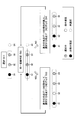
- FIG. 3 is a second diagram for explaining the outline of the process of thinning out point data of points other than the start point and end point of the straight line portion.
- the travel data storage server 200 of the present embodiment selects three point data from the travel data database 210 (step S1).
- the point data selected here is the point data of the point 31 indicated by the nth position information acquired by the mobile terminal 300, the point data of the point 32 indicated by the n + 1th acquired position information, and the n + 2th acquired. This is point data of the point 33 indicated by the position information.
- the point data in which the order in which the position information is acquired continues is referred to as continuous point data.
- the point data of the starting point 31 among the three consecutive point data is the non-exclusion target point data.
- the non-exclusion target point data is point data that is determined to be stored in the drawing travel data database 220.
- the travel data storage server 200 determines whether or not the three selected points are on the same straight line (step S2).
- step S2 when the three points are on the same straight line, the travel data storage server 200 excludes the point data of the point 32 located in the middle among the three points. Then, the travel data storage server 200 selects a point 34 that is continuous with the point 33, and returns to step S2 (step S3). In this embodiment, the point data to be excluded is not stored in the drawing travel data database 220.
- step S2 when the three points are not on the same straight line, the traveling data storage server 200 sets the point data of the point 32 as non-exclusion target point data. Then, the travel data storage server 200 selects three consecutive points 32, 33, 34 starting from the point 32, and returns to step S2 (step S4).
- the traveling data storage server 200 of the present embodiment repeats this process to create a drawing traveling data database 220 excluding point data on points other than the end point and starting point on the straight line from the traveling data.
- FIG. 4 is a diagram illustrating an example of a hardware configuration of the travel data storage server.
- the travel data storage server 200 of the present embodiment includes an input device 21, an output device 22, a drive device 23, an auxiliary storage device 24, a memory device 25, an arithmetic processing device 26, and an interface device 27 that are connected to each other via a bus B. including.
- the input device 21 includes a keyboard and a mouse and is used for inputting various signals.
- the output device 22 includes a display device and the like, and is used to display various windows and data.
- the interface device 27 includes a modem, a LAN card, and the like, and is used for connecting to a network.
- the travel data storage program is at least a part of various programs that control the travel data storage server 200.
- the traveling data storage program is provided by, for example, distribution of the recording medium 28 or downloading from a network.
- the recording medium 28 on which the traveling data storage program is recorded is a recording medium such as a CD-ROM, a flexible disk, a magneto-optical disk, etc. for recording information optically, electrically or magnetically, a ROM, a flash memory, etc.
- Various types of recording media such as a semiconductor memory for electrically recording information can be used.
- the travel data storage program is installed from the recording medium 28 to the auxiliary storage device 24 via the drive device 23 when the recording medium 28 on which the travel data storage program is recorded is set in the drive device 23.
- the travel data storage program downloaded from the network is installed in the auxiliary storage device 24 via the interface device 27.
- the auxiliary storage device 24 stores the installed travel data storage program and also stores necessary files, data, and the like.
- the memory device 25 reads and stores the travel data storage program from the auxiliary storage device 24 when the computer is activated.
- the arithmetic processing unit 26 implements various processes as described later in accordance with the travel data storage program stored in the memory device 25.
- the mobile terminal 300 and the terminal device 400 of the present embodiment are, for example, a general computer or a tablet, and the hardware configuration thereof is the same as that of the travel data storage server 200, and thus the description thereof is omitted.
- a display operation device having a display function may be provided instead of the input device 21 and the output device 22.
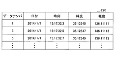
- FIG. 5 is a diagram showing an example of a travel data database.
- the travel data database 210 of the present embodiment is provided in association with the vehicle 10 and is associated with identification information or the like that identifies the vehicle 10. Therefore, when the travel data storage server 200 receives travel data for a plurality of vehicles, the travel data storage server 200 has the number of travel data databases 210 corresponding to the number of vehicles.
- the travel data database 210 of this embodiment may be provided in the auxiliary storage device 24 of the travel data storage server 200, for example.
- the travel data database 210 includes a data number, date, time, latitude, and longitude as information items.
- the value of the item “data number” is associated with the values of other items.
- information including the value of the item “data number” and the values of other items is referred to as point data.
- position information a combination of latitude and longitude included in the point data is referred to as position information. That is, the location data is included in the point data.
- the value of the item “data number” is an identifier for specifying point data.
- the value of the item “date” indicates the date when the values of the items “latitude” and “longitude” are acquired.
- the value of the item “time” indicates the time when the values of the items “latitude” and “longitude” are acquired.
- the values of the item “latitude” and the item “longitude” are the latitude and longitude acquired by the mobile terminal 300 at predetermined intervals.
- FIG. 6 is a diagram for explaining the function of the travel data storage server.
- the travel data storage server 200 of the present embodiment includes a travel data storage processing unit 230 and a drawing processing unit 240.
- the travel data storage processing unit 230 of the present embodiment is realized by the arithmetic processing unit 26 of the travel data storage server 200 executing a travel data storage program.
- the drawing processing unit 240 of the present embodiment is realized, for example, when the arithmetic processing device 26 of the travel data storage server 200 executes a drawing program.
- the travel data storage processing unit 230 of the present embodiment includes a travel data reception unit 231, a spot selection unit 232, a linear calculation unit 233, an exclusion determination unit 234, and a drawing point data storage unit 235.
- the travel data reception unit 231 of the present embodiment receives travel data input and stores it in the travel data database 210.
- the point selection unit 232 refers to the travel data database 210 and selects three points to be subjected to determination processing by the exclusion determination unit 234 described later in order from the point that is the starting point (departure point) of the travel route indicated by the travel data. To do.
- the straight line calculation unit 233 obtains position information of the three points selected by the point selection unit 232, and calculates a value for determining whether or not the three points are considered to be on the same straight line. Based on the value calculated by the linear equation calculation unit 233, the exclusion determination unit 234 determines whether the point data of the middle point among the three points is to be excluded or not.
- the point selection unit 232, the linear calculation unit 233, and the exclusion determination unit 234 of the present embodiment play a role of the generation unit 250 that generates drawing point data. Details of the linear calculation unit 233 and the exclusion determination unit 234 will be described later.
- the drawing point data storage unit 235 stores the point data of the points determined as non-exclusion targets by the exclusion determination unit 234 in the drawing travel data database 220.
- the drawing processing unit 240 of this embodiment includes a screen data generation unit 241 and a screen data output unit 242.
- the screen data generation unit 241 receives a travel route display request of the vehicle 10
- the screen data generation unit 241 generates screen data of a screen in which the travel route of the vehicle 10 is drawn on the map with reference to the drawing travel data database 220. To do.
- the screen data output unit 242 transmits the screen data generated by the screen data generation unit 241 to the device that has requested display of the travel route.
- the expression (1) is referred to as a linear expression.
- the linear formula is based on the premise that the grid on the coordinate plane is square when the scales are marked on the X axis and the Y axis and the grid lines are drawn along the scales of both axes.
- latitude and longitude are used as coordinate axes, and the length per degree of latitude and the length per degree of longitude may not be the same. That is, when latitude and longitude are used for the coordinate axes, the grid in the coordinate plane is often not a square, and the linear calculation result is generally not zero.
- the travel route of the vehicle 10 is a straight line.
- the travel route is preferably determined to be a straight line if the meandering width is within the width of the road.
- the three points are the same from the relationship between the distance from the straight line connecting the starting point and the ending point of the three points to the middle point and the absolute value of the linear calculation result.
- a threshold value used for determining whether or not they are on a straight line is set. In this embodiment, when the absolute value of the linear calculation result is equal to or less than the threshold value, the three points are considered to be on the same straight line.
- FIG. 7 is a diagram for explaining the relationship between the distance from the line connecting the start point and end point of the three points to the middle point and the absolute value of the linear calculation result.
- the grid on the coordinate plane is assumed to be a square.
- FIG. 7A shows an example in which the coordinates of the point A are (1, 1), the coordinates of the point B are (2, 3), and the coordinates of the point C are (3, 3).
- the absolute value ⁇ is 2 when the absolute value of the linear calculation result is ⁇ .
- the distance d between the point 71 and the straight line 71 connecting the point A and the point C and the point B is ⁇ 2 / 2.
- FIG. 7B shows an example in which the coordinates of the point A are (1, 1), the coordinates of the point B are (3, 1), and the coordinates of the point C are (3, 3). Also in this case, the relationship between the absolute value ⁇ of the calculation result of the linear equation and the distance d is Equation (2).
- Equation (2) the relationship between the absolute value ⁇ of the calculation result of the linear equation and the distance d is expressed by Equation (2).
- the threshold for the absolute value ⁇ of the linear calculation result is set by setting the distance d.
- the absolute value of the linear calculation result ⁇ 2.8 (rounded to the second decimal place). Therefore, in this embodiment, when the middle point of the three points is within a width of 2 [m] centered on the straight line connecting the start point and the end point of the three points, the three points are on the same straight line.
- the threshold value for the absolute value ⁇ of the linear calculation result may be 2.8.
- d 3.5 and the absolute value of the linear calculation result
- the threshold value for ⁇ may be 9.9.
- the middle point among the three points when the middle point among the three points is within a predetermined range from the straight line connecting the start point and the end point, it is determined that the three points are on the same straight line, Excludes the point data of the point.
- the center point when the center point is outside the predetermined range from the straight line connecting the start point and the end point, it is determined that these three points are not on the same straight line, and the point data of the center point is not stored. Excluded.
- the exclusion determination unit 234 of the present embodiment has three points on the same straight line when the absolute value ⁇ of the linear expression calculation result calculated by the linear expression calculation unit 233 is equal to or less than a threshold value.
- the point data of the middle point is excluded.
- the exclusion determination unit 234 of the present embodiment considers that the three points are not on the same straight line when the absolute value ⁇ of the calculation result of the linear equation calculated by the linear equation calculation unit 233 is larger than the threshold value, The point data in the middle is not excluded.
- FIG. 8 is a flowchart for explaining the operation of the travel data storage server.
- the travel data storage server 200 of this embodiment refers to the travel data database 210 in which the travel data received by the travel data receiving unit 231 is stored (step S801). Subsequently, the travel data storage server 200 uses the exclusion determination unit 234 to determine the point data of the top point of the travel data database 210 as a non-exclusion target (step S802). The leading point data is point data of the starting point of the travel route.
- the travel data storage server 200 selects three consecutive points from the top in the travel data database 210 by the point selection unit 232 (step S803). Subsequently, the travel data storage server 200 acquires position information (latitude and longitude) of each point from the point data of the three selected points by the linear calculation unit 233 (step S804).
- the linear equation calculation unit 233 substitutes the acquired position information of the three points into the linear equation, and calculates the absolute value ⁇ of the linear equation calculation result (step S805).
- the travel data storage server 200 determines whether or not the absolute value ⁇ of the linear calculation result is equal to or less than a preset threshold value by the exclusion determination unit 234 (step S806). If it is greater than the threshold value in step S806, the process proceeds to step S810 described later. In step S806, if it is equal to or less than the threshold value, the exclusion determining unit 234 determines the point data of the second point (middle point) among the three points as the point data to be excluded (step S807).
- step S807 the travel data storage server 200 determines whether or not the next location data exists in the travel data database 210 by the location selection unit 232 (step S808). If it is determined in step S808 that there is no next point, the process proceeds to step S813 described later.
- step S808 when there is a next point, the travel data storage server 200 selects one point ahead of the third point among the three points selected in step S803 by the point selection unit 232, The first, third, and fourth points are set as new three points (step S809), and the process returns to step S804. That is, the point selection unit 232 reads the point data of the fourth point where the times are continuous, and sets the first, third, and fourth points as new three points.
- step S806 when larger than the threshold value, the travel data storage server 200 determines the point data of the second point (middle point) among the three points as non-exclusion target point data (step S810).
- the travel data storage server 200 determines whether or not the next location data exists in the travel data database 210 by the location selection unit 232 (step S811). In step S811, when there is no next point, the process proceeds to step S813 described later.
- step S811 if there is a next point, the travel data storage server 200 selects a point that is the third point ahead of the three points selected in step S803 by the point selection unit 232, The second, third, and fourth points are set as new three points (step S812), and the process returns to step S804.
- step S808 and step S811 when the next point does not exist, the traveling data storage server 200 determines the point data of the third point as non-exclusion target point data by the exclusion determination unit 234 (step S813).
- the point data of the third point in step S813 is the point data at the end of the travel data database 210, that is, the point data of the end point (arrival point) of the travel route.
- the travel data storage server 200 stores the spot data determined as a non-exclusion target in the drawing travel data database 220 by the drawing spot data storage unit 235 (step S814), and ends the process.
- FIG. 9 is a diagram for explaining the operation of the travel data storage server.
- the point selection unit 232 determines the top spot data in the travel data database 210 as a non-exclusion target.
- the top spot data in the travel data database 210 of the present embodiment is spot data with a data number “1” (see FIG. 5).
- the point data of the data number “1” is the point data of the starting point of the travel route.
- the point selection unit 232 selects three point data from the data number “1” to the data number “3” in the travel data database 210, and acquires a latitude value and a longitude value from each point data. Then, the linear calculation unit 233 obtains the absolute value ⁇ of the linear calculation result, and the exclusion determination unit 234 determines whether or not the point data of the data number “2” is to be excluded.
- the point indicated by the point data with the data number “2” is determined to be on the same straight line as the point indicated by the point data with the data numbers “1” and “3”. To be confirmed.
- the point selection unit 232 selects the data number “1”, the data number “3”, and the data number “4” that is the point data next to the point data of the data number “3”, and performs the same processing. And determine whether or not the data number “3” is an exclusion target.
- the point indicated by the point data with the data number “3” is determined not to be on the same straight line as the point indicated by the point data with the data numbers “1” and “4”. Confirmed with data.
- the point selection unit 232 selects the three point data in order from the point data of the data number “3” that is the point data that is not excluded after the data number “1”. Therefore, the point data with the data numbers “3” to “5” are selected here.
- the traveling data storage server 200 performs the same processing on the three point data, and determines whether or not the data number “4” is an exclusion target.
- the travel data storage server 200 of the present embodiment stores the spot data determined as a non-exclusion target in the drawing travel data database 220.
- FIG. 10 is a diagram showing an example of the drawing travel data database.
- the drawing travel data database 220 of this embodiment is provided in association with the travel data database 210. Therefore, the drawing travel data database 220 may store information indicating the association with the travel data database 210.
- the drawing travel data database 220 stores the identification information of the vehicle 10 included in the travel data database 210, and may be associated with the travel data database 210 by the identification information of the vehicle 10.
- the drawing travel data database 220 of the present embodiment stores spot data that is not subject to exclusion from the spot data stored in the travel data database 210.
- the point data of the data number “1” that is the starting point of the travel route, the point data of the data number “3” that is not excluded, and the data number “5” as shown in FIG. Point data is stored.
- the number of spot data stored in the drawing travel data database 220 of this embodiment is smaller than the number of spot data stored in the travel data database 210, and the amount of data is reduced.
- the drawing processing unit 240 of the present embodiment draws a travel route with reference to the drawing travel data database 220, the load related to the drawing processing is reduced compared to the drawing processing with reference to the travel data database 210.
- FIG. 11 is a flowchart for explaining processing of the drawing processing unit.
- the travel data storage server 200 of the present embodiment determines whether or not the drawing processing unit 240 has received a display request for the travel route of the vehicle 10 (step S111). In step S111, when a display request is not received, it waits until a display request is received.
- step S111 when the display request is accepted, the drawing processing unit 240 refers to the drawing travel data database 220 corresponding to the vehicle that has received the travel route display request by the screen data generation unit 241 (step S112).
- the drawing processing unit 240 uses the point data stored in the drawing travel data database 220 to generate screen data of a screen in which the travel route is drawn on the map (step S113).
- the map data for displaying the map may be stored in the travel data storage server 200, or may be acquired from an external server or the like.
- the drawing processing unit 240 outputs the generated screen data to the device that has requested display by the screen data output unit 242 (step S114), and ends the process.
- the drawing processing unit 240 displays drawing travel data obtained by excluding point data of points other than the start point and the end point of the route regarded as a straight line from all the point data acquired by the mobile terminal 300. Therefore, the amount of data to be handled is reduced, and the load of drawing processing is reduced.
Landscapes
- Engineering & Computer Science (AREA)
- Radar, Positioning & Navigation (AREA)
- Remote Sensing (AREA)
- Automation & Control Theory (AREA)
- Physics & Mathematics (AREA)
- General Physics & Mathematics (AREA)
- Navigation (AREA)
- Traffic Control Systems (AREA)
- Instructional Devices (AREA)
Abstract
出発地点から到着地点までの車両の緯度及び経度を所定時間毎に取得して、該緯度及び経度を取得した時刻に対応付けた第一の走行データを受け付け、前記第一の走行データの内の時間が連続する3以上の緯度及び経度のデータを読み出し、該連続する3以上の緯度及び経度のデータの内の両端の2点を結ぶ直線から所定の範囲以内に存在するデータについて削除する制御を行うことで第二の走行データを生成し、生成した該第二の走行データを記憶部に格納する、処理をコンピュータに実行させる。
Description
本発明は、走行データを記憶する走行データ記憶プログラム、走行データ記憶方法及び走行データ記憶装置に関する。
従来から、道路の整備や補修等の一環として、路面の状態等を調査する調査用の車両に携帯端末を搭載して道路を走行し、携帯端末が所定時間毎に収集した位置情報に応じて地図上に走行したルートを描画する技術が知られている。
従来の技術では、走行したルートを描画する際に、携帯端末が取得した全ての位置情報を用いるため、描画の処理負荷が高い。
1つの側面では、ルートを描画する際の処理負荷を軽減することが可能な走行データ記憶プログラム、走行データ記憶方法及び走行データ記憶装置を提供することを目的としている。
一様態によれば、出発地点から到着地点までの車両の緯度及び経度を所定時間毎に取得して、該緯度及び経度を取得した時刻に対応付けた第一の走行データを受け付け、前記第一の走行データの内の時間が連続する3以上の緯度及び経度のデータを読み出し、該連続する3以上の緯度及び経度のデータの内の両端の2点を結ぶ直線から所定の範囲以内に存在するデータについて削除する制御を行うことで第二の走行データを生成し、生成した該第二の走行データを記憶部に格納する、処理をコンピュータに実行させる。
上記各処理は、上記各処理を実現する機能部、各処理を手順としてコンピュータにより実行させる方法、プログラムを記憶したコンピュータ読み取り可能な記憶媒体とすることもできる。
ルートを描画する際の処理負荷を軽減できる。
以下に図面を参照して実施形態について説明する。図1は、走行データ記憶システムの一例を示す図である。
本実施形態の走行データ記憶システム100は、走行データ記憶サーバ200と、携帯端末300と、を有する。走行データ記憶サーバ200は、携帯端末300とネットワーク等を介して接続される。
本実施形態の走行データ記憶サーバ200は、走行データデータベース210と、描画用走行データデータベース220と、走行データ記憶処理部230と、描画処理部240と、を有する。
本実施形態の携帯端末300は、例えば道路を走行して路面の状態を調査する調査用の車両10等に搭載され、所定時間毎に車両10の位置情報を取得する。次に携帯端末300は、位置情報と位置情報を取得した時刻とを対応付けた地点データの集合を、車両10の走行ルートを示す走行データとして走行データ記憶サーバ200へ送信する。本実施形態の位置情報は、緯度と経度で示されるものであり、携帯端末300の有するGPS(Global Positioning System)機能により取得される。
本実施形態の走行データ記憶サーバ200は、携帯端末300から走行データを受信すると、走行データデータベース210に格納する。
また、本実施形態の走行データ記憶サーバ200は、走行データデータベース210に格納された走行データから、走行ルートにおける直線部分の始点と終点以外の地点の地点データを間引く処理を行う。そして、走行データ記憶サーバ200は、この処理により除外(削除)されなかった残りの地点データの集合を、描画用走行データとして描画用走行データデータベース220に格納する。
言い換えれば、本実施形態の走行データ記憶サーバ200は、受け付けた第一の走行データから、走行ルートにおける直線部分の始点と終点以外の地点の地点データを削除した第二の走行データを生成し、第二の走行データを描画用走行データデータベース220に格納する。
したがって、本実施形態では、描画用走行データは、走行データよりもデータ量が削減されたものとなる。
また、本実施形態の走行データ記憶サーバ200は、端末装置400から、車両10の走行ルートの表示要求を受けて、描画処理部240に、描画用走行データデータベース220を参照させる。描画処理部240は、描画用走行データデータベース220に基づき、地図上に走行ルートを描画した画面の画面データを生成し、端末装置400へ送信する。
すなわち本実施形態では、走行ルートを描画する際に、走行データのデータ量を削減した描画用走行データに基づき描画処理を行う。よって、本実施形態によれば、描画処理の際に読み出すデータ量を削減することができ、さらに削減されたデータにより描画処理を行うため、処理の負荷を軽減できる。
尚、図1の例では、端末装置400は走行データ記憶システム100に含まれないものとしたが、端末装置400は、走行データ記憶システム100に含まれても良い。
また、図1の例では、走行ルートが描画された画面データの送信先を端末装置400としたが、これに限定されない。走行データ記憶サーバ200は、例えば携帯端末300から車両10の走行ルートの表示要求を受けた場合には、携帯端末300に画面データを送信しても良いし、走行データ記憶サーバ200の表示装置に走行ルートを描画した画面を表示させても良い。
また、図1の例では、走行データ記憶サーバ200は、携帯端末300から走行データを受信するものとしたが、これに限定されない。本実施形態の走行データ記憶サーバ200は、例えば携帯端末300が取得した走行データが格納された記憶媒体等から、走行データを読み取っても良い。
また、図1の例では、描画処理部240は、走行データ記憶サーバ200に設けられるものとしたが、これに限定されない。描画処理部240は、例えば携帯端末300や端末装置400が有しても良い。この場合、走行データ記憶サーバ200は、例えば端末装置400から車両10の走行ルートの表示要求を受けた際に、端末装置400の描画処理部に対して、描画用走行データデータベース220を参照するように指示すれば良い。
以下に、図2及び図3を参照して、直線部分の始点と終点以外の地点の地点データを間引く処理の概要を説明する。
図2は、直線部分の始点と終点以外の地点の地点データを間引く処理の概要を説明する第一の図である。
本実施形態では、走行データデータベース210に格納されている走行データから、直線の始点の地点データと、終点の地点データ及びカーブを描く地点の地点データのみを用いて走行ルートを描画する。
図2の例では、走行ルートR1に直線L1、カーブC1、直線L2が含まれる。この場合、本実施形態では、直線L1の始点P1と終点P2の間の地点の地点データを除外する。また、本実施形態では、カーブC1の始点P2とカーブC1の終点P4の間の地点P3の地点データは除外しない。本実施形態では、直線L2についても同様に、直線L2の始点P4と終点P5の間の地点の地点データを除外する。
したがって、図2に示す走行ルートR1の描画用走行データは、地点P1と地点P2の間の地点の地点データと、地点P4と地点P5の間の地点の地点データとが除外された、地点P1、P2、P3、P4、P5の地点データとなる。
図3は、直線部分の始点と終点以外の地点の地点データを間引く処理の概要を説明する第二の図である。
本実施形態の走行データ記憶サーバ200は、走行データデータベース210から、3つの地点データを選択する(ステップS1)。ここで選択される地点データは、携帯端末300によりn番目に取得された位置情報が示す地点31の地点データ、n+1番目に取得された位置情報が示す地点32の地点データ、n+2番目に取得された位置情報が示す地点33の地点データである。
以下の説明では、位置情報が取得された順が連続する地点データを連続する地点データと呼ぶ。ここで、本実施形態では、連続する3つの地点データのうち、始点となる地点31の地点データは、非除外対象の地点データとする。非除外対象の地点データとは、描画用走行データデータベース220に格納されることが確定している地点データである。
続いて、走行データ記憶サーバ200は、選択された3地点が同一の直線上にあるか否かを判定する(ステップS2)。
ステップS2において、3つの地点が同一の直線上にある場合、走行データ記憶サーバ200は、3つの地点のうち、真ん中に位置する地点32の地点データを除外対象とする。そして、走行データ記憶サーバ200は、地点33と連続する地点34を選択し、ステップS2へ戻る(ステップS3)。尚、本実施形態では、除外対象とされた地点データは、描画用走行データデータベース220に格納されない。
ステップS2において、3つの地点が同一の直線上にない場合、走行データ記憶サーバ200は、地点32の地点データを非除外対象の地点データとする。そして、走行データ記憶サーバ200は、地点32を始点とした連続する3つの地点32、33、34を選択し、ステップS2に戻る(ステップS4)。
本実施形態の走行データ記憶サーバ200は、この処理を繰り返すことで、走行データから直線上の終点と始点以外の地点の地点データを除外した描画用走行データデータベース220を作成する。
次に図4を参照し、本実施形態の走行データ記憶サーバ200のハードウェア構成について説明する。図4は、走行データ記憶サーバのハードウェア構成の一例を示す図である。
本実施形態の走行データ記憶サーバ200は、それぞれバスBで相互に接続されている入力装置21、出力装置22、ドライブ装置23、補助記憶装置24、メモリ装置25、演算処理装置26及びインターフェース装置27を含む。
入力装置21はキーボードやマウス等を含み、各種信号を入力するために用いられる。出力装置22はディスプレイ装置等を含み、各種ウインドウやデータ等を表示するために用いられる。インターフェース装置27は、モデム、LANカード等を含み、ネットワークに接続する為に用いられる。
走行データ記憶プログラムは、走行データ記憶サーバ200を制御する各種プログラムの少なくとも一部である。走行データ記憶プログラムは例えば記録媒体28の配布やネットワークからのダウンロードなどによって提供される。走行データ記憶プログラムを記録した記録媒体28は、CD-ROM、フレキシブルディスク、光磁気ディスク等の様に情報を光学的、電気的或いは磁気的に記録する記録媒体、ROM、フラッシュメモリ等の様に情報を電気的に記録する半導体メモリ等、様々なタイプの記録媒体を用いることができる。
また、走行データ記憶プログラムは、走行データ記憶プログラムを記録した記録媒体28がドライブ装置23にセットされるとは記録媒体28からドライブ装置23を介して補助記憶装置24にインストールされる。ネットワークからダウンロードされた走行データ記憶プログラムは、インターフェース装置27を介して補助記憶装置24にインストールされる。
補助記憶装置24は、インストールされた走行データ記憶プログラムを格納すると共に、必要なファイル、データ等を格納する。メモリ装置25は、コンピュータの起動時に補助記憶装置24から走行データ記憶プログラムを読み出して格納する。そして、演算処理装置26はメモリ装置25に格納された走行データ記憶プログラムに従って、後述するような各種処理を実現している。
また、本実施形態の携帯端末300と端末装置400は、例えば一般的なコンピュータやタブレット等であり、そのハードウェア構成は走行データ記憶サーバ200と同様であるから説明を省略する。尚、携帯端末300がタブレットやスマートフォン等であった場合には、入力装置21と出力装置22の代わりに、表示機能を有する表示操作装置を有していても良い。
図5は、走行データデータベースの一例を示す図である。本実施形態の走行データデータベース210は、車両10と対応付けられて設けられるものであり、車両10を特定する識別情報等が対応付けられている。したがって、走行データ記憶サーバ200は、複数の車両の走行データを受け付けた場合には、車両の数と対応する数の走行データデータベース210を有することになる。
本実施形態の走行データデータベース210は、例えば走行データ記憶サーバ200の補助記憶装置24等に設けられていても良い。
本実施形態の走行データデータベース210は、情報の項目として、データナンバと、日付と、時刻と、緯度と、経度とを有する。本実施形態では、項目「データナンバ」の値と、他の項目の値とが対応付けられている。以下の説明では、項目「データナンバ」の値と、他の項目の値とを含む情報を地点データと呼ぶ。また、以下の説明では、地点データに含まれる緯度及び経度の組を、位置情報と呼ぶ。すなわち、地点データには位置情報が含まれる。
項目「データナンバ」の値は、地点データを特定するための識別子である。項目「日付」の値は、項目「緯度」及び「経度」の値を取得した日を示す。項目「時刻」の値は、項目「緯度」及び「経度」の値を取得した時刻を示す。項目「緯度」及び項目「経度」の値は、携帯端末300が所定間隔毎に取得した緯度及び経度である。
図6は、走行データ記憶サーバの機能を説明する図である。本実施形態の走行データ記憶サーバ200は、走行データ記憶処理部230と、描画処理部240と、を有する。本実施形態の走行データ記憶処理部230は、走行データ記憶サーバ200の演算処理装置26が走行データ記憶プログラムを実行することにより実現される。本実施形態の描画処理部240は、例えば走行データ記憶サーバ200の演算処理装置26が描画プログラムを実行することにより実現される。
本実施形態の走行データ記憶処理部230は、走行データ受付部231、地点選択部232、直線式演算部233、除外判定部234、描画用地点データ格納部235を有する。
本実施形態の走行データ受付部231は、走行データの入力を受け付け、走行データデータベース210に格納する。
地点選択部232は、走行データデータベース210を参照し、走行データが示す走行ルートの始点(出発地点)となる地点から順に、後述する除外判定部234による判定処理の対象となる3つの地点を選択する。
直線式演算部233は、地点選択部232により選択された3つの地点の位置情報を取得し、3つの地点が同一直線上にあると見なすか否かを判定するための値を算出する。除外判定部234は、直線式演算部233により算出された値に基づき、3つの地点のうち真ん中の地点の地点データを除外対象とするか、又は非除外対象とするかを判定する。
すなわち、本実施形態の地点選択部232と、直線式演算部233と、除外判定部234とは、描画用地点データを生成する生成部250の役割を果たす。
直線式演算部233と除外判定部234の詳細は後述する。
直線式演算部233と除外判定部234の詳細は後述する。
描画用地点データ格納部235は、除外判定部234により、非除外対象と判定された地点の地点データを描画用走行データデータベース220に格納する。
本実施形態の描画処理部240は、画面データ生成部241と、画面データ出力部242とを有する。本実施形態の画面データ生成部241は、車両10の走行ルートの表示要求を受け付けると、描画用走行データデータベース220を参照し、車両10の走行ルートを地図上に描画した画面の画面データを生成する。
画面データ出力部242は、画面データ生成部241が生成した画面データを、走行ルートの表示要求を行った装置へ送信する。
以下に、本実施形態の直線式演算部233と除外判定部234の処理について説明する。
地点A、B、Cの3点が同一直線上にあるための必要十分条件は、地点Aの座標を(Xa,Ya)とし、地点Bの座標を(Xb,Yb)とし、地点Cの座標を(Xc,Yc)とした場合、数学的には、以下の式(1)を満たすことである。
Ya(Xb-Xc)+Yb(Xc-Xa)+Yc(Xa-Xb)=0 式(1)
本実施形態では、式(1)を直線式と呼ぶ。直線式は、X軸とY軸とに目盛りを打ち、両軸の目盛りに沿ってグリッド線を引いた際の座標平面における格子が正方形になることが前提である。
しかしながら、本実施形態では、緯度と経度を座標軸に用いており、緯度1度当たりの長さと、経度1度当たりの長さは同じではない場合がある。すなわち、緯度と経度を座標軸に用いた場合、座標平面における格子は正方形とはならないことが多く、直線式の演算結果が0にならないことが一般的である。
さらに、本実施形態では、車両10の走行ルートが直線であるか否かを判定することを前提としている。この判定では、例えば車両10の走行ルートが車線変更等により蛇行していても、蛇行の幅が道路の幅以内であれば走行ルートを直線と判定することが好ましい。
本実施形態では、これらの点に着目し、3つの地点の始点と終点を結んだ直線から真ん中の地点までの距離と、直線式の演算結果の絶対値との関係から、3つの地点が同一直線上にあるか否かの判定に用いる閾値を設定する。そして、本実施形態では、直線式の演算結果の絶対値が閾値以下である場合に3つの地点は同一直線上にあるものと見なす。
図7は、3つの地点の始点と終点を結んだ線から真ん中の地点までの距離と、直線式の演算結果の絶対値との関係を説明する図である。尚、図7の例では、座標平面上の格子は正方形であるものとした。
図7(A)は、地点Aの座標を(1,1)、地点Bの座標を(2,3)、地点Cの座標を(3,3)とした場合の例である。
この場合、直線式の演算結果の絶対値をβとしたとき、絶対値βは2となる。また、地点Aと地点Cとを結んだ直線71と、地点Bとの距離dは√2/2である。
したがって、直線式の演算結果の絶対値βと、距離dとの関係は、以下の式(2)で示される。
β=2√2d 式(2)
図7(B)は、地点Aの座標を(1,1)、地点Bの座標を(3,1)、地点Cの座標を(3,3)とした場合の例である。この場合も、直線式の演算結果の絶対値βと、距離dとの関係は、式(2)となる。
図7(B)は、地点Aの座標を(1,1)、地点Bの座標を(3,1)、地点Cの座標を(3,3)とした場合の例である。この場合も、直線式の演算結果の絶対値βと、距離dとの関係は、式(2)となる。
これらの例から、直線式の演算結果の絶対値βと距離dとの関係は、式(2)で示されることがわかる。
そこで、本実施形態では、距離dを設定することで、直線式の演算結果の絶対値βに対する閾値を設定する。
例えば、距離d=1[m]とした場合、直線式の演算結果の絶対値β=2.8(小数点第二位以下四捨五入)である。したがって、本実施形態では、3つの地点の真ん中の地点が、3つの地点の始点と終点を結んだ直線を中心とした幅2[m]以内にある場合に、3つの地点を同一直線上と判定させる場合には、直線式の演算結果の絶対値βに対する閾値を2.8とすれば良い。
この場合、本実施形態では、直線式の演算結果の絶対値βが2.8以下の場合に、3つの地点が同一直線上であると判定される。
さらに、例えば幅が3.5mの車線を片側2車線有する直線道路において、車線変更を無視して走行ルートから直線部分を検出する場合、d=3.5とし、直線式の演算結果の絶対値βに対する閾値を9.9とすれば良い。
このように、本実施形態では、3つの地点のうち真ん中の地点が、始点と終点を結ぶ直線から所定の範囲内にある場合に、この3つの地点を同一直線上にあると判定し、真ん中の地点の地点データを除外対象とする。また、本実施形態では、真ん中の地点が、始点と終点を結ぶ直線から所定の範囲外にある場合に、この3つの地点を同一直線上にないと判定し、真ん中の地点の地点データを非除外対象とする。
言い換えれば、本実施形態の除外判定部234は、直線式演算部233により算出された直線式の演算結果の絶対値βが、閾値以下である場合に、3つの地点を同一直線上にあるものと見なし、真ん中の地点の地点データを除外対象とする。また、本実施形態の除外判定部234は、直線式演算部233により算出された直線式の演算結果の絶対値βが、閾値より大きい場合に、3つの地点が同一直線上にないと見なし、真ん中の地点の地点データを非除外対象とする。
以下に、図8を参照して本実施形態の走行データ記憶サーバ200の動作について説明する。
図8は、走行データ記憶サーバの動作を説明するフローチャートである。本実施形態の走行データ記憶サーバ200は、走行データ受付部231により受け付けた走行データが格納された走行データデータベース210を参照する(ステップS801)。続いて、走行データ記憶サーバ200は、除外判定部234により、走行データデータベース210の先頭の地点の地点データを非除外対象に確定する(ステップS802)。先頭の地点データは、走行ルートの始点の地点データである。
続いて、走行データ記憶サーバ200は、地点選択部232により、走行データデータベース210において先頭から連続する3つの地点を選択する(ステップS803)。続いて走行データ記憶サーバ200は、直線式演算部233により、選択された3つの地点の地点データから、それぞれの地点の位置情報(緯度と経度)を取得する(ステップS804)。
続いて走行データ記憶サーバ200は、直線式演算部233は、取得した3つの地点の位置情報を直線式に代入し、直線式の演算結果の絶対値βを算出する(ステップS805)。
続いて走行データ記憶サーバ200は、除外判定部234により、直線式の演算結果の絶対値βが、予め設定された閾値以下であるか否かを判定する(ステップS806)。ステップS806において、閾値より大きい場合、後述するステップS810へ進む。ステップS806において、閾値以下であった場合、除外判定部234は、3つの地点のうち、2つ目の地点(真ん中の地点)の地点データを除外対象の地点データに確定する(ステップS807)。
ステップS807に続いて、走行データ記憶サーバ200は、地点選択部232により、走行データデータベース210に、次の地点データが存在するか否かを判定する(ステップS808)。ステップS808において、次の地点が存在しない場合、後述するステップS813へ進む。
ステップS808において、次の地点が存在する場合、走行データ記憶サーバ200は、地点選択部232により、ステップS803で選択した3地点のうち、3つ目の地点の1つ先の地点を選択し、1つ目、3つ目、4つ目の地点を新たな3地点とし(ステップS809)、ステップS804へ戻る。すなわち、地点選択部232は、時刻が連続する4つ目の地点の地点データを読み出し、1つ目、3つ目、4つ目の地点を新たな3地点とする。
ステップS806において、閾値より大きい場合、走行データ記憶サーバ200は、3つの地点のうち、2つ目の地点(真ん中の地点)の地点データを非除外対象の地点データに確定する(ステップS810)。
続いて走行データ記憶サーバ200は、地点選択部232により、走行データデータベース210に、次の地点データが存在するか否かを判定する(ステップS811)。ステップS811において、次の地点が存在しない場合、後述するステップS813へ進む。
ステップS811において、次の地点が存在する場合、走行データ記憶サーバ200は、地点選択部232により、ステップS803で選択した3地点のうち、3つ目の地点の1つ先の地点を選択し、2つ目、3つ目、4つ目の地点を新たな3地点とし(ステップS812)、ステップS804へ戻る。
ステップS808及びステップS811において、次の地点が存在しない場合、走行データ記憶サーバ200は、除外判定部234により、3つ目の地点の地点データを非除外対象の地点データに確定する(ステップS813)。ステップS813における3つ目の地点の地点データは、走行データデータベース210の末尾の地点データ、すなわち走行ルートの終点(到着地点)の地点データである。
続いて走行データ記憶サーバ200は、描画用地点データ格納部235により、非除外対象に確定された地点データを描画用走行データデータベース220に格納し(ステップS814)、処理を終了する。
以下に、図9及び図10を参照し、本実施形態の走行データ記憶サーバ200の処理について具体的に説明する。
図9は、走行データ記憶サーバの動作を説明する図である。本実施形態の走行データ記憶サーバ200は、地点選択部232により、走行データデータベース210の先頭の地点データを非除外対象に確定する。本実施形態の走行データデータベース210の先頭の地点データとは、データナンバ「1」の地点データである(図5参照)。ここでは、データナンバ「1」の地点データは、走行ルートの始点の地点データである。
続いて地点選択部232は、走行データデータベース210のデータナンバ「1」からデータナンバ「3」までの3つの地点データを選択し、各地点データから緯度の値と経度の値を取得する。そして、直線式演算部233により、直線式の演算結果の絶対値βを求め、除外判定部234によりデータナンバ「2」の地点データを除外対象とするか否かを判定する。
図9の例では、データナンバ「2」の地点データが示す点は、データナンバ「1」及び「3」の地点データか示す点と同一直線上にあると判定されたため、除外対象の地点データに確定される。
続いて、地点選択部232は、データナンバ「1」、データナンバ「3」と、データナンバ「3」の地点データの次の地点データであるデータナンバ「4」を選択し、同様の処理を行い、データナンバ「3」が除外対象であるか否かを判定する。
図9の例では、データナンバ「3」の地点データが示す点は、データナンバ「1」及び「4」の地点データが示す点と同一直線上にないと判定されたため、非除外対象の地点データに確定される。
続いて、地点選択部232は、データナンバ「1」の次に非除外対象とされた地点データであるデータナンバ「3」の地点データから順に、3つの地点データを選択する。よって、ここでは、データナンバ「3」~「5」の地点データが選択される。
走行データ記憶サーバ200は、この3つの地点データについて、同様の処理を行い、データナンバ「4」が除外対象であるか否かを判定する。
図9の例では、データナンバ「4」の地点データが示す点は、データナンバ「3」及び「5」の地点データが示す点と同一直線上にあると判定されたため、除外対象の地点データに確定される。
本実施形態では、以上のように、走行データデータベース210に格納された各地点データについて、除外対象となるか否かを判定する。そして、本実施形態の走行データ記憶サーバ200は、非除外対象に確定された地点データを描画用走行データデータベース220に格納する。
図10は、描画用走行データデータベースの一例を示す図である。本実施形態の描画用走行データデータベース220は、走行データデータベース210と対応付けて設けられるものである。したがって、描画用走行データデータベース220は、走行データデータベース210との対応付けを示す情報が格納されていても良い。また、描画用走行データデータベース220には、走行データデータベース210が有する車両10の識別情報が格納されており、車両10の識別情報により、走行データデータベース210と対応付けられても良い。
本実施形態の描画用走行データデータベース220は、走行データデータベース210に格納されている地点データのうち、非除外対象とされた地点データが格納されている。
図10の例では、走行ルートの始点となるデータナンバ「1」の地点データと、図9に示すように、非除外対象とされたデータナンバ「3」の地点データ、データナンバ「5」の地点データが格納されている。
また、図10に示す描画用走行データデータベース220では、除外対象とされたデータナンバ「2」及びデータナンバ「4」の地点データは格納されていないことがわかる。したがって、本実施形態の描画用走行データデータベース220に格納される地点データの数は、走行データデータベース210に格納される地点データの数よりも少なくなり、データ量が削減される。
本実施形態の描画処理部240は、描画用走行データデータベース220を参照して走行ルートの描画を行うため、走行データデータベース210を参照した描画処理と比較して、描画処理に係る負荷が軽減される。
以下に、図11を参照し、本実施形態の描画処理部240の処理について説明する。図11は、描画処理部の処理を説明するフローチャートである。
本実施形態の走行データ記憶サーバ200は、描画処理部240により、車両10の走行ルートの表示要求を受け付けたか否かを判定する(ステップS111)。ステップS111において、表示要求を受け付けない場合、表示要求を受け付けるまで待機する。
ステップS111において、表示要求を受け付けると、描画処理部240は、画面データ生成部241により、走行ルートの表示要求を受け付けた車両と対応する描画用走行データデータベース220を参照する(ステップS112)。
続いて描画処理部240は、描画用走行データデータベース220に格納された地点データを用いて、地図上に走行ルートが描画された画面の画面データを生成する(ステップS113)。尚、地図を表示させるための地図データは、走行データ記憶サーバ200に格納されていても良いし、外部のサーバ等から取得しても良い。
続いて描画処理部240は、画面データ出力部242により、生成した画面データを、表示要求を行った装置に対して出力し(ステップS114)、処理を終了する。
以上のように、本実施形態の描画処理部240は、携帯端末300が取得した全ての地点データから、直線と見なされるルートの始点と終点以外の地点の地点データを除外した描画用走行データを参照するため、取り扱うデータ量が削減され、描画処理の負荷が軽減される。
本発明は、具体的に開示された実施形態に限定されるものではなく、特許請求の範囲から逸脱することなく、種々の変形や変更が可能である。
本出願は、2015年2月26日に出願された日本国特許出願第2015-36901号に基づきその優先権を主張するものであり、同日本国特許出願の全内容を参照することにより本願に援用する。
100 走行データ記憶システム
200 走行データ記憶サーバ
210 走行データデータベース
220 描画用走行データデータベース
230 走行データ記憶処理部
232 地点選択部
233 直線式演算部
234 除外判定部
235 描画用地点データ格納部
240 描画処理部
241 画面データ生成部
242 画面データ取出力部
300 携帯端末
400 端末装置
200 走行データ記憶サーバ
210 走行データデータベース
220 描画用走行データデータベース
230 走行データ記憶処理部
232 地点選択部
233 直線式演算部
234 除外判定部
235 描画用地点データ格納部
240 描画処理部
241 画面データ生成部
242 画面データ取出力部
300 携帯端末
400 端末装置
Claims (9)
- 出発地点から到着地点までの車両の緯度及び経度を所定時間毎に取得して、該緯度及び経度を取得した時刻に対応付けた第一の走行データを受け付け、
前記第一の走行データの内の時間が連続する3以上の緯度及び経度のデータを読み出し、
該連続する3以上の緯度及び経度のデータの内の両端の2点を結ぶ直線から所定の範囲以内に存在するデータについて削除する制御を行うことで第二の走行データを生成し、
生成した該第二の走行データを記憶部に格納する、処理をコンピュータに実行させる走行データ記憶プログラム。 - 前記出発地点から前記到着地点までの走行ルートの表示要求を受けて、
前記走行ルートを描画した画面の画面データを生成する描画処理部に、前記第二の走行データが格納された前記記憶部を参照させる、処理を前記コンピュータに実行させる請求項1記載の走行データ記憶プログラム。 - 前記第二の走行データを生成する処理は、
前記第一の走行データの内の時間が連続する3の緯度及び経度のデータを読み出し、
前記3の緯度及び経度のデータの内の両端の2点を結ぶ直線と、中間にある点との距離が、前記所定の範囲内にあるか否かを判定し、
前記距離が前記所定の範囲内にある場合に、前記中間にある点のデータを削除し、
前記連続する3の緯度及び経度のデータのうち、最も取得された時刻の遅いデータの次に取得された緯度及び経度のデータを読み出し、
前記中間にある点のデータを除く3の緯度及び経度のデータに対し、前記判定する処理を繰り返す、請求項2記載の走行データ記憶プログラム。 - 前記第二の走行データを生成する処理は、
前記距離が前記所定の範囲内にない場合に、前記中間にある点を含み、且つ前記中間にある点から連続する3の緯度及び経度のデータを読み出し、
前記判定する処理を繰り返す、請求項3記載の走行データ記憶プログラム。 - 前記判定する処理は、
前記3の緯度及び経度のデータを、平面上で3点が1直線上にあるための必要十分条件を示す式に代入した際の演算結果の絶対値が、前記距離に応じて設定された閾値以下である場合に、
前記距離が前記所定の範囲内にあると判定する請求項4記載の走行データ記憶プログラム。 - 前記第二の走行データを生成する処理は、
前記出発地点から到着地点の緯度及び経度のデータを前記第二の走行データに含める請求項5記載の走行データ記憶プログラム。 - コンピュータによる走行データ記憶方法であって、該コンピュータが、
出発地点から到着地点までの車両の緯度及び経度を所定時間毎に取得して、該緯度及び経度を取得した時刻に対応付けた第一の走行データを受け付け、
前記第一の走行データの内の時間が連続する3以上の緯度及び経度のデータを読み出し、
該連続する3以上の緯度及び経度のデータの内の両端の2点を結ぶ直線から所定の範囲以内に存在するデータについて削除する制御を行うことで第二の走行データを生成し、
生成した該第二の走行データを記憶部に格納する、走行データ記憶方法。 - 出発地点から到着地点までの車両の緯度及び経度を所定時間毎に取得して、該緯度及び経度を取得した時刻に対応付けた第一の走行データを受け付ける走行データ受付部と、
前記第一の走行データの内の時間が連続する3以上の緯度及び経度のデータを読み出し、
該連続する3以上の緯度及び経度のデータの内の両端の2点を結ぶ直線から所定の範囲以内に存在するデータについて削除する制御を行うことで第二の走行データを生成する生成部と、
生成した該第二の走行データを記憶部に格納する格納部と、を有する走行データ記憶装置。 - 出発地点から到着地点までの車両の緯度及び経度を所定時間毎に取得して、該緯度及び経度を取得した時刻に対応付けた地点データを含む第一の走行データを受け付け、
前記第一の走行データの内の時間が連続する3以上の地点データを読み出し、
該連続する3以上の地点データの内の、各地点データが示す地点の両端を結ぶ直線から所定の範囲以内に存在する地点の地点データを、前記第一の走行データから除外した第二の走行データを生成し、
前記第二の走行データを記憶部に格納する、処理をコンピュータに実行させる走行データ記憶プログラム。
Priority Applications (1)
| Application Number | Priority Date | Filing Date | Title |
|---|---|---|---|
| US15/684,473 US20170350710A1 (en) | 2015-02-26 | 2017-08-23 | Computer-readable recording medium, method, and apparatus for storing traveling data |
Applications Claiming Priority (2)
| Application Number | Priority Date | Filing Date | Title |
|---|---|---|---|
| JP2015036901A JP6485111B2 (ja) | 2015-02-26 | 2015-02-26 | 走行データ記憶プログラム、走行データ記憶方法及び走行データ記憶装置 |
| JP2015-036901 | 2015-02-26 |
Related Child Applications (1)
| Application Number | Title | Priority Date | Filing Date |
|---|---|---|---|
| US15/684,473 Continuation US20170350710A1 (en) | 2015-02-26 | 2017-08-23 | Computer-readable recording medium, method, and apparatus for storing traveling data |
Publications (1)
| Publication Number | Publication Date |
|---|---|
| WO2016136303A1 true WO2016136303A1 (ja) | 2016-09-01 |
Family
ID=56789253
Family Applications (1)
| Application Number | Title | Priority Date | Filing Date |
|---|---|---|---|
| PCT/JP2016/050708 Ceased WO2016136303A1 (ja) | 2015-02-26 | 2016-01-12 | 走行データ記憶プログラム、走行データ記憶方法及び走行データ記憶装置 |
Country Status (3)
| Country | Link |
|---|---|
| US (1) | US20170350710A1 (ja) |
| JP (1) | JP6485111B2 (ja) |
| WO (1) | WO2016136303A1 (ja) |
Citations (2)
| Publication number | Priority date | Publication date | Assignee | Title |
|---|---|---|---|---|
| JP2005249443A (ja) * | 2004-03-02 | 2005-09-15 | Xanavi Informatics Corp | ナビゲーションシステム、ナビゲーション装置 |
| JP2013140425A (ja) * | 2011-12-28 | 2013-07-18 | Jvc Kenwood Corp | 車載器、位置情報送信方法、及び位置情報送信プログラム |
Family Cites Families (2)
| Publication number | Priority date | Publication date | Assignee | Title |
|---|---|---|---|---|
| JP5633632B2 (ja) * | 2011-03-17 | 2014-12-03 | 富士通株式会社 | 電子装置、情報配信システム、コンピュータプログラム及び位置依存情報提供方法 |
| US9863780B2 (en) * | 2012-06-10 | 2018-01-09 | Apple Inc. | Encoded representation of traffic data |
-
2015
- 2015-02-26 JP JP2015036901A patent/JP6485111B2/ja not_active Expired - Fee Related
-
2016
- 2016-01-12 WO PCT/JP2016/050708 patent/WO2016136303A1/ja not_active Ceased
-
2017
- 2017-08-23 US US15/684,473 patent/US20170350710A1/en not_active Abandoned
Patent Citations (2)
| Publication number | Priority date | Publication date | Assignee | Title |
|---|---|---|---|---|
| JP2005249443A (ja) * | 2004-03-02 | 2005-09-15 | Xanavi Informatics Corp | ナビゲーションシステム、ナビゲーション装置 |
| JP2013140425A (ja) * | 2011-12-28 | 2013-07-18 | Jvc Kenwood Corp | 車載器、位置情報送信方法、及び位置情報送信プログラム |
Also Published As
| Publication number | Publication date |
|---|---|
| US20170350710A1 (en) | 2017-12-07 |
| JP2016161278A (ja) | 2016-09-05 |
| JP6485111B2 (ja) | 2019-03-20 |
Similar Documents
| Publication | Publication Date | Title |
|---|---|---|
| CN110260867B (zh) | 一种机器人导航中位姿确定、纠正的方法、设备及装置 | |
| JP7211605B2 (ja) | 地形を考慮したルート計画 | |
| JP6427908B2 (ja) | 地図情報生成システム、方法およびプログラム | |
| US7460952B2 (en) | Navigation apparatus, and data processing method and computer program used therewith | |
| CN106598054B (zh) | 机器人路径调整方法及装置 | |
| EP3951700A1 (en) | Method, apparatus, and computer program product for generating an overhead view of an environment from a perspective image | |
| CN101750081B (zh) | 移动体的地图匹配装置及其方法 | |
| EP3023740B1 (en) | Method, apparatus and computer program product for route matching | |
| WO2011068070A1 (ja) | 車載情報処理装置および走行支援装置 | |
| US20080228389A1 (en) | Route-selection-supporting device, method, and program | |
| EP3859716B1 (en) | Map data high refinement system, and server and method for same | |
| CN109932738A (zh) | 用于确定对象位置的方法和设备 | |
| WO2019188165A1 (ja) | 地図提供装置 | |
| WO2020105189A1 (ja) | 経路計画装置、経路計画方法、及びコンピュータ読み取り可能な記録媒体 | |
| JP2011076279A (ja) | 走行リンク確定装置及びリンク旅行時間算出装置 | |
| CN111627249A (zh) | 驾驶辅助系统、驾驶辅助方法和非暂时性计算机可读介质 | |
| CN104034338A (zh) | 一种动态导航方法及装置 | |
| US11598645B2 (en) | Driving assistance system, route guidance system, driving assistance method, and driving assistance program | |
| WO2014020886A1 (ja) | センタ装置、プログラム、地図情報送信方法、及びナビゲーション装置 | |
| JP2004004029A (ja) | ナビゲーション装置 | |
| JP6485111B2 (ja) | 走行データ記憶プログラム、走行データ記憶方法及び走行データ記憶装置 | |
| JP6936673B2 (ja) | 地図データ更新システムおよび地図データ更新プログラム | |
| JP6607657B2 (ja) | 新規道路推定支援装置、新規道路推定支援方法、コンピュータプログラム及びコンピュータプログラムを記録した記録媒体 | |
| CN116714604A (zh) | 车辆绕行方向决策方法、装置、车辆及存储介质 | |
| CN111308997A (zh) | 用于生成行驶路径的方法和装置 |
Legal Events
| Date | Code | Title | Description |
|---|---|---|---|
| 121 | Ep: the epo has been informed by wipo that ep was designated in this application |
Ref document number: 16755053 Country of ref document: EP Kind code of ref document: A1 |
|
| NENP | Non-entry into the national phase |
Ref country code: DE |
|
| 122 | Ep: pct application non-entry in european phase |
Ref document number: 16755053 Country of ref document: EP Kind code of ref document: A1 |