WO2012064036A9 - Method for providing a custom map via an information block - Google Patents
Method for providing a custom map via an information block Download PDFInfo
- Publication number
- WO2012064036A9 WO2012064036A9 PCT/KR2011/008107 KR2011008107W WO2012064036A9 WO 2012064036 A9 WO2012064036 A9 WO 2012064036A9 KR 2011008107 W KR2011008107 W KR 2011008107W WO 2012064036 A9 WO2012064036 A9 WO 2012064036A9
- Authority
- WO
- WIPO (PCT)
- Prior art keywords
- information
- user
- providing
- information block
- local
- Prior art date
Links
Images


Classifications
-
- G—PHYSICS
- G01—MEASURING; TESTING
- G01C—MEASURING DISTANCES, LEVELS OR BEARINGS; SURVEYING; NAVIGATION; GYROSCOPIC INSTRUMENTS; PHOTOGRAMMETRY OR VIDEOGRAMMETRY
- G01C21/00—Navigation; Navigational instruments not provided for in groups G01C1/00 - G01C19/00
- G01C21/38—Electronic maps specially adapted for navigation; Updating thereof
- G01C21/3863—Structures of map data
- G01C21/3867—Geometry of map features, e.g. shape points, polygons or for simplified maps
-
- G—PHYSICS
- G01—MEASURING; TESTING
- G01C—MEASURING DISTANCES, LEVELS OR BEARINGS; SURVEYING; NAVIGATION; GYROSCOPIC INSTRUMENTS; PHOTOGRAMMETRY OR VIDEOGRAMMETRY
- G01C21/00—Navigation; Navigational instruments not provided for in groups G01C1/00 - G01C19/00
- G01C21/26—Navigation; Navigational instruments not provided for in groups G01C1/00 - G01C19/00 specially adapted for navigation in a road network
- G01C21/34—Route searching; Route guidance
- G01C21/36—Input/output arrangements for on-board computers
- G01C21/3667—Display of a road map
- G01C21/367—Details, e.g. road map scale, orientation, zooming, illumination, level of detail, scrolling of road map or positioning of current position marker
Definitions
- the present invention relates to a method for providing specific local information using a user terminal in a wired / wireless network environment.
- the present invention provides a method for easily utilizing local information by providing local information in a method customized to an individual user.
- the present invention relates to a method of providing a customized map by using an information block.
- the local information currently being serviced through the mobile terminal allows the user to display the location requested by the user on the actual map screen, and to obtain detailed information, the user selects the local information displayed on the map and provides detailed local information. It is common to use it.
- the mobile terminal has a narrow screen, relatively slow hardware, and is used in a relatively slow network environment due to its inherent characteristics to be suitable for mobility. You will have considerable difficulties.
- the present invention has been proposed in order to solve the above problems, and an object of the present invention is to provide a local information in an optimally customized way to the user information block, characterized in that to facilitate the use of local information
- the purpose of the present invention is to provide a customized map providing method.
- a method of providing a customized map by an information block of the present invention provides local information based on geographic information to a user terminal connected to a local information providing system through a network, and generates a specific area. And receiving the received local information from the providing system at the request of the user and displaying the personalized area information on the user terminal, wherein the provided personalized area information is displayed on the user terminal. Calculating the bearing and distance of each personalized area information from the user's real-time location, and determining and displaying the location according to the relative bearing and distance between the area information in the previously displayed area information frame arranged in a honeycomb form.
- the personalized area information is displayed in the form of a hexagon in consideration of the position and distance relative to the honeycomb area information frame, thereby providing a customized map to the user so that the local information can be easily utilized.
- the user can intuitively check and select the area information displayed efficiently by the information block, and maintain and manage his / her own personalized area information.
- the local information can be easily utilized.
- the present invention is not limited to the provision of the closed local information service, and has the effect of providing a basis for creating a personalized local information of its own by being linked to various other applications utilizing other local information in three dimensions.
- the sharing of local information between users through Twitter, etc., and the effect of improving the chances of human exchange are provided, which allows users to implement a wider social network.
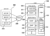
- FIG. 1 is a structural diagram in which a system enabling a method of providing a customized map by an information block according to the present invention is connected through a network.
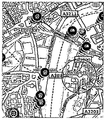
- FIG. 2 is a screen diagram for providing local information using a conventional map.
- FIG. 3 is a screen diagram for providing local information by the method according to the present invention.
- FIG. 4 is a screen diagram showing the addition of a new information block in FIG.
- 5 and 6 are screen diagrams showing that the method according to the present invention is linked to a road guide application service.
- FIG. 7 is a screen diagram showing that an information block includes additional information in providing local information according to the present invention.
- FIG. 8 is a screen diagram illustrating a process of including an information block from multimedia content according to the present invention.
- FIG. 9 is a screen diagram illustrating a process of including location information of a user as additional information in an information block according to the present invention.
- a method of providing a customized map by an information block according to the present invention is performed by each user accessing a local information providing system through his / her terminal 300 or 310 using a wired / wireless network 200, wherein the local information providing system
- the local information providing system As an example, as shown in Figure 1 is made as follows.
- the system is composed of a DB server 110, a local information providing server 120 and an application service providing server 130, the DB server 110 has a basic geographic information such as by name, phone number, place name Geographic information section 111 is stored and provides basic data for the generation of local information, and a local information data field for storing the regional information generated for a specific region by the user's request, etc., each data field in each user Personalized data fields 112 personalized by request are stored in a separate folder.
- the local information providing server 120 processes the personalized local information into information blocks and relocates the information based on the user's real time location in consideration of the relative positions and distances between the information blocks, and the user's request. Accordingly, the information block and the additional area information is provided to the user terminal, and according to the additional request consists of a local information management unit 121 that manages the connection to the application service.
- the application service providing server 130 drives a separate application service linked to the map service according to the user's request and provides necessary support, and typically includes a road guide unit 131 for guiding a route from the current location of the user terminal to a selected destination. ), An event unit 132 for providing advertisements, events, discount information, and the like to the user terminal in the local information, and a social network unit 133 linked to a social network service such as Twitter.
- a social network service such as Twitter.
- any service using the local information can be linked to the customized map providing method of the present invention, of course.
- the present invention is intended to enable users to intuitively use their own personalized local information in utilizing a variety of local information based on geographic information by using a user's own terminal, and only the essential local information for this information block By displaying on the screen with the concept of 'necessary' all unnecessary local information is excluded.
- the local information may be a specific address, a concept of a specific office, or a location of a specific person. If the local information is displayed on a general map, as shown in FIG. It is displayed in the form of a point based on geographic information.
- the actual geographic information can be helpful in confirming the absolute location of specific local information.
- it may be an obstacle to confirming the necessary local information. It is rather desirable to provide only.
- the personalized area information selected by the user and personalized as a kind of bookmark is displayed on the screen, but the standardized area having a predetermined area is not a simple point.
- the standardized area having a predetermined area is not a simple point.
- the shape of the information block can be standardized in a variety of forms, such as a circle, a square or a star or a specific figure.
- FIG. It was illustrated that the arrangement in the form of a honeycomb as a whole having a hexagonal shape that can be appropriately and efficiently reflected.
- each one of the personalized local information appears as a hexagonal information block and the relative position around the user's real-time location
- the location is determined and displayed on the local information frame 311 which is arranged and displayed in a honeycomb form on the screen.
- the personalized local information is stored in a personalized data field assigned to each user and provided to the user terminal upon request.
- the process of storing a specific local information in the personalized data field is an example of a user address or name. It can be added to the personalized data field automatically by searching for, intentionally add a specific place to the personalized data field in the form of favorites, or can be forcibly added to the personalized data field by recommendation of others as described below. have. Alternatively, it may be excluded by deleting from the personalized data field by the choice.
- the relative orientation and distance of each region are calculated and displayed on the user's screen based on the real-time location of the user. Calculate the direction and distance of each personalized area information from the user's real-time location, and determine and display the location according to the relative direction and distance between the area information in the previously displayed area information frame arranged in a honeycomb form. After displaying the local information on the screen, whenever the change in the user's location is reflected, the user can always maintain a spatial sense of the personalized local information centered on his location.
- the method of providing a customized map according to the present invention is not a closed service but is linked with other services using local information, so that all services related to the map are provided, and a gate interface for accessing the service more easily. ) Can utilize the method of providing a customized map of the present invention.
- the information block displayed on the screen of the user generally indicates the name of the region, but the present invention is not limited thereto, and various additional information may be displayed on the name to provide various additional applications.
- the temporary block 30% discount event is presented as an example in the name of the information block. The user can easily recognize and select this to easily receive event information.
- the present invention may provide additional benefits by not only providing local information for the user's convenience of checking local information but also by allowing commercial activities, and deleting such additional information from personalized local information when not needed. By doing so, it can no longer appear in the user's local information, thereby minimizing user's rejection.
- the local information displayed as an information block on the screen of the user may be added to the personalized local information by searching for an address or a name or intentionally added through contents including geographic information.
- an information block can be added from photo content stored in a user terminal and include geographic information.
- the user can designate a photo stored in his terminal through an information block addition option.
- the user can add an information block displayed as a picture by selecting the picture. In this case, the location of the picture is displayed on the screen relative to the user.
- the information block may be added through an Open Source social network service represented by 'Twitter', 'Foursqure', 'Gowalla', etc.
- an Open Source social network service represented by 'Twitter', 'Foursqure', 'Gowalla', etc.
- FIG. In the process of using the user or other people, including the geographic information registered 'Flamingo Cantiana' by selecting the local information is added to the personalized local information is available to the user.
- the fixed location or the real time location of another user may be represented by an information block displayed on the screen of the user according to the present invention.
- the information block displayed on the screen of the user indicates the user
- the information can be easily delivered to the user through the transfer between the information blocks.
- the present invention is characterized in that it provides optimally and efficiently only the local information that is essential to each user-including the location information of the user-so that it is easy to identify the local information that is important to them and to easily use them. Will be.
- the personalized local information stored as a separate personalized data field for each user may be provided as an open source so that other users can check the contents by searching.
- each user can easily and intuitively recognize only the local information necessary for the user, and can easily use and manage it. .
Landscapes
- Engineering & Computer Science (AREA)
- Radar, Positioning & Navigation (AREA)
- Remote Sensing (AREA)
- Physics & Mathematics (AREA)
- Automation & Control Theory (AREA)
- General Physics & Mathematics (AREA)
- Geometry (AREA)
- Information Transfer Between Computers (AREA)
- Instructional Devices (AREA)
- Mobile Radio Communication Systems (AREA)
- Digital Computer Display Output (AREA)
- User Interface Of Digital Computer (AREA)
- Navigation (AREA)
Abstract
Description
Claims (6)
- 네트워크를 통하여 지역정보 제공시스템에 연결된 사용자 단말기에 지리정보를 기반으로 한 맞춤형 지도를 제공하는 방법에 있어서,In the method for providing a customized map based on geographic information to the user terminal connected to the local information providing system through a network,특정 지역에 대하여 생성된 지역정보를 상기 사용자의 요청에 의하여 제공시스템으로부터 제공받아 사용자 단말기에 개인화 지역정보로 표시하는 과정을 포함하여 이루어지되,Including the process of displaying the local information generated for a specific area from the providing system at the request of the user to display the personalized area information on the user terminal,상기 제공된 개인화 지역정보가 사용자 단말기에 표시되는 과정은,The process of displaying the provided personalized area information on the user terminal,사용자의 실시간 위치를 산출하는 과정과, 사용자 실시간 위치로부터 각각의 개인화 지역정보의 방위 및 거리를 산출하고, 벌집 형태로 배열된채 미리 표시된 지역정보틀에서 지역정보들간의 상대적인 방위 및 거리에 따라 위치를 결정하여 표시하는 과정을 포함하여 이루어져,The process of calculating the user's real-time location, and calculating the direction and distance of each personalized area information from the user's real-time location, the position according to the relative orientation and distance between the area information in the pre-displayed area information frame arranged in a honeycomb form Including the process of determining and displaying the,사용자 단말기의 실시간 위치를 중심으로 상기 개인화 지역정보를 벌집 형태의 지역정보틀에 상대적인 위치와 거리를 고려하여 육각형의 형태로 표시함으로써, 자신에게 맞춤화된 지도를 제공하여 지역정보를 용이하게 활용할 수 있도록 하는 것을 특징으로 하는 정보블록에 의한 맞춤형 지도 제공방법.Based on the real-time location of the user terminal, the personalized area information is displayed in the form of a hexagon in consideration of the position and distance relative to the honeycomb area information frame, so that the user can easily utilize the local information by providing a customized map. Customized map providing method by the information block, characterized in that.
- 청구항 1에 있어서,The method according to claim 1,상기 표시된 특정 정보블록을 선택하면 실시간 위치로부터 해당 지역정보까지 안내하는 길안내 모드로 연동되는 과정을 더 포함하는 것을 특징으로 하는 정보블록에 의한 맞춤형 지도 제공방법.The method of providing a customized map according to an information block, further comprising the step of interlocking with a road guide mode for guiding from the real-time location to the corresponding local information when the specific information block is displayed.
- 청구항 1에 있어서,The method according to claim 1,상기 표시된 특정 정보블록은 해당 지역정보의 부가 정보를 더 표시함으로써 정보블록을 선택하면 부가 정보를 제공받는 것을 특징으로 하는 정보블록에 의한 맞춤형 지도 제공방법.The displayed specific information block further displays additional information of the corresponding local information, so that when the information block is selected, additional information is provided.
- 청구항 1에 있어서,The method according to claim 1,다수의 지역에 분산하여 위치하는 특정 지역정보에 대하여는 사용자 단말기의 실시간 위치에서 가장 근접한 지역정보만을 추출하여 제공하는 과정을 더 포함하는 것을 특징으로 하는 정보블록에 의한 맞춤형 지도 제공방법.The method for providing customized maps according to an information block, comprising: extracting and providing only local information closest to the real-time location of the user terminal with respect to specific local information distributed in a plurality of regions.
- 청구항 1에 있어서,The method according to claim 1,상기 특정 지역정보는 타 사용자의 현재 위치정보에 관한 것으로, 소셜 네트워크 서비스에 연동하거나 전화번호정보에 연동하여 타 사용자의 위치정보를 추가로 제공받는 것을 특징으로 하는 정보블록에 의한 맞춤형 지도 제공방법.The specific area information relates to the current location information of another user, and provides a customized map by the information block, characterized in that additionally provided with the location information of another user in conjunction with a social network service or phone number information.
- 청구항 5에 있어서,The method according to claim 5,일 정보블록을 타 사용자의 위치정보에 관한 정보블록으로 드래그 앤드 드롭을 하면 해당 정보블록의 지역정보가 타 사용자에게 제공되는 동시에 피제공 사용자의 개인화 데이터필드에 해당 지역정보가 추가되는 것을 특징으로 하는 정보블록에 의한 맞춤형 지도 제공방법.Dragging and dropping an information block to an information block related to the location information of another user provides local information of the corresponding information block to other users and adds the corresponding local information to the personalized data field of the provided user. How to provide customized map by information block.
Priority Applications (3)
| Application Number | Priority Date | Filing Date | Title |
|---|---|---|---|
| JP2013536519A JP5802759B2 (en) | 2010-11-12 | 2011-10-28 | How to provide a ready-to-use map with information blocks |
| US13/879,777 US9074893B2 (en) | 2010-11-12 | 2011-10-28 | Method for providing a custom map via an information block |
| CN201180054142.0A CN103270530B (en) | 2010-11-12 | 2011-10-28 | The offer method of self-defined map based on chunk |
Applications Claiming Priority (2)
| Application Number | Priority Date | Filing Date | Title |
|---|---|---|---|
| KR20100112796A KR101045252B1 (en) | 2010-11-12 | 2010-11-12 | Providing method of regional information by information block |
| KR10-2010-0112796 | 2010-11-12 |
Publications (3)
| Publication Number | Publication Date |
|---|---|
| WO2012064036A2 WO2012064036A2 (en) | 2012-05-18 |
| WO2012064036A3 WO2012064036A3 (en) | 2012-07-19 |
| WO2012064036A9 true WO2012064036A9 (en) | 2012-08-16 |
Family
ID=44406261
Family Applications (1)
| Application Number | Title | Priority Date | Filing Date |
|---|---|---|---|
| PCT/KR2011/008107 WO2012064036A2 (en) | 2010-11-12 | 2011-10-28 | Method for providing a custom map via an information block |
Country Status (5)
| Country | Link |
|---|---|
| US (1) | US9074893B2 (en) |
| JP (1) | JP5802759B2 (en) |
| KR (1) | KR101045252B1 (en) |
| CN (1) | CN103270530B (en) |
| WO (1) | WO2012064036A2 (en) |
Families Citing this family (6)
| Publication number | Priority date | Publication date | Assignee | Title |
|---|---|---|---|---|
| CN103257991A (en) * | 2012-02-16 | 2013-08-21 | 吉菲斯股份有限公司 | Method and system for associating user interests with zones and maps |
| US10025468B2 (en) * | 2013-11-15 | 2018-07-17 | Google Llc | Personalization of map content via an application programming interface |
| CN104020998B (en) * | 2014-06-13 | 2018-01-30 | 百度在线网络技术(北京)有限公司 | A kind of generation method and device of User Defined map |
| US10337876B2 (en) | 2016-05-10 | 2019-07-02 | Microsoft Technology Licensing, Llc | Constrained-transportation directions |
| US10386197B2 (en) | 2016-05-17 | 2019-08-20 | Microsoft Technology Licensing, Llc | Calculating an optimal route based on specified intermediate stops |
| US10060752B2 (en) | 2016-06-23 | 2018-08-28 | Microsoft Technology Licensing, Llc | Detecting deviation from planned public transit route |
Family Cites Families (19)
| Publication number | Priority date | Publication date | Assignee | Title |
|---|---|---|---|---|
| JP3594673B2 (en) * | 1994-12-21 | 2004-12-02 | 株式会社ハドソン | Traffic information display |
| JP3724108B2 (en) * | 1997-04-02 | 2005-12-07 | 株式会社デンソー | Traffic information display device |
| US6144920A (en) * | 1997-08-29 | 2000-11-07 | Denso Corporation | Map displaying apparatus |
| JPH11282863A (en) * | 1998-03-30 | 1999-10-15 | Seiko Epson Corp | Information presentation system and information presenting method |
| JP2002116044A (en) * | 2000-10-10 | 2002-04-19 | Alpine Electronics Inc | Navigation device |
| JP2004070773A (en) * | 2002-08-08 | 2004-03-04 | Mazda Motor Corp | Information center and computer program for providing information |
| TWI220508B (en) * | 2003-05-02 | 2004-08-21 | Sin Etke Technology Co Ltd | Easy vehicle navigation method and system |
| JP4470094B2 (en) * | 2003-11-05 | 2010-06-02 | ソニー株式会社 | Map direction display method |
| JP5592594B2 (en) * | 2004-03-23 | 2014-09-17 | グーグル インコーポレイテッド | Digital mapping system |
| KR100655090B1 (en) * | 2004-04-28 | 2006-12-08 | 팅크웨어(주) | A method for managing informarion of registration points by category in navigation system and a system thereof |
| KR100667489B1 (en) * | 2004-10-28 | 2007-01-10 | 주식회사 현대오토넷 | Apparatus for displaying location information of a mobile phone user by a car navigation system and method thereof |
| KR101091308B1 (en) * | 2005-05-20 | 2011-12-07 | 엘지전자 주식회사 | Methods and apparatus of hexagonal menu interface for mobile phone |
| KR100879661B1 (en) * | 2006-02-22 | 2009-01-20 | (주)케이티에프테크놀로지스 | Mobile Terminal of sorting Address Data according to Position of User |
| US7881864B2 (en) * | 2006-05-31 | 2011-02-01 | Garmin Switzerland Gmbh | Method and apparatus for utilizing geographic location information |
| JP4891691B2 (en) * | 2006-07-31 | 2012-03-07 | ヤフー株式会社 | Method and system for retrieving data with location information added |
| US8903936B2 (en) * | 2006-12-21 | 2014-12-02 | Blackberry Limited | Sharing user defined location based zones |
| JP4929114B2 (en) * | 2007-09-28 | 2012-05-09 | 日産自動車株式会社 | Vehicle information notifying device, information providing system, and information notifying method |
| JP5233320B2 (en) * | 2008-02-27 | 2013-07-10 | ソニー株式会社 | Data processing system and data processing method |
| JP5175709B2 (en) * | 2008-12-08 | 2013-04-03 | ヤフー株式会社 | Direction display device, direction display method, and direction display program |
-
2010
- 2010-11-12 KR KR20100112796A patent/KR101045252B1/en active IP Right Grant
-
2011
- 2011-10-28 US US13/879,777 patent/US9074893B2/en active Active
- 2011-10-28 JP JP2013536519A patent/JP5802759B2/en not_active Expired - Fee Related
- 2011-10-28 WO PCT/KR2011/008107 patent/WO2012064036A2/en active Application Filing
- 2011-10-28 CN CN201180054142.0A patent/CN103270530B/en active Active
Also Published As
| Publication number | Publication date |
|---|---|
| JP2014502386A (en) | 2014-01-30 |
| CN103270530A (en) | 2013-08-28 |
| WO2012064036A2 (en) | 2012-05-18 |
| CN103270530B (en) | 2016-08-17 |
| WO2012064036A3 (en) | 2012-07-19 |
| KR101045252B1 (en) | 2011-06-29 |
| US9074893B2 (en) | 2015-07-07 |
| JP5802759B2 (en) | 2015-11-04 |
| US20130218454A1 (en) | 2013-08-22 |
Similar Documents
| Publication | Publication Date | Title |
|---|---|---|
| WO2012064036A2 (en) | Method for providing a custom map via an information block | |
| Ratti et al. | Mobile landscapes: using location data from cell phones for urban analysis | |
| Kaasinen | User needs for location-aware mobile services | |
| AU2012360730B2 (en) | An apparatus, method and computer program for displaying points of interest | |
| WO2012044025A2 (en) | Method of creating and joining social group, user device for executing the method, server, and storage medium | |
| US9537961B2 (en) | Open type POI service system using SNS method and method thereof | |
| WO2014176897A1 (en) | Method and device for displaying detailed map information | |
| JP2011040012A (en) | Passenger information providing system for sales car | |
| CN103248671B (en) | A kind of service providing method, service providing apparatus and server | |
| JP2014112426A (en) | Passenger information providing system for business vehicle | |
| KR101045690B1 (en) | Residential parking management system | |
| JP4956651B2 (en) | Navigation system, route search server, terminal device, and route guidance method | |
| Steiniger et al. | Foundations of LBS | |
| WO2020184750A1 (en) | Trip record generating server and method | |
| WO2013077540A1 (en) | Real-time location based mobile local social service system and method for providing mobile local social service using same | |
| CN109584705B (en) | Map display method and device | |
| Vrček et al. | User acceptance of location-based services | |
| KR20120137617A (en) | System for providing a social network service based on a position using a smart phone | |
| WO2015167136A1 (en) | Virtual padlock providing system | |
| JP2013117905A (en) | Information display medium with rfid tag and information display medium system with rfid tag | |
| JP5920140B2 (en) | Information sharing system, information sharing method, and terminal device | |
| JP7267137B2 (en) | Information processing equipment | |
| JP2009002821A (en) | Navigation system, route search server and terminal device and route guiding method | |
| Zhang et al. | A metro smart card data-based analysis of group travel behaviour in Shanghai, China | |
| WO2018018199A1 (en) | Shortest distance-based hotel reservation method and room reservation system |
Legal Events
| Date | Code | Title | Description |
|---|---|---|---|
| 121 | Ep: the epo has been informed by wipo that ep was designated in this application |
Ref document number: 11839703 Country of ref document: EP Kind code of ref document: A2 |
|
| WWE | Wipo information: entry into national phase |
Ref document number: 13879777 Country of ref document: US |
|
| ENP | Entry into the national phase |
Ref document number: 2013536519 Country of ref document: JP Kind code of ref document: A |
|
| NENP | Non-entry into the national phase |
Ref country code: DE |
|
| 122 | Ep: pct application non-entry in european phase |
Ref document number: 11839703 Country of ref document: EP Kind code of ref document: A2 |