WO2005001794A1 - Coordinate mutual converting module - Google Patents
Coordinate mutual converting module Download PDFInfo
- Publication number
- WO2005001794A1 WO2005001794A1 PCT/JP2004/009006 JP2004009006W WO2005001794A1 WO 2005001794 A1 WO2005001794 A1 WO 2005001794A1 JP 2004009006 W JP2004009006 W JP 2004009006W WO 2005001794 A1 WO2005001794 A1 WO 2005001794A1
- Authority
- WO
- WIPO (PCT)
- Prior art keywords
- mesh
- code
- unit
- digits
- longitude
- Prior art date
Links
Classifications
-
- G—PHYSICS
- G09—EDUCATION; CRYPTOGRAPHY; DISPLAY; ADVERTISING; SEALS
- G09B—EDUCATIONAL OR DEMONSTRATION APPLIANCES; APPLIANCES FOR TEACHING, OR COMMUNICATING WITH, THE BLIND, DEAF OR MUTE; MODELS; PLANETARIA; GLOBES; MAPS; DIAGRAMS
- G09B29/00—Maps; Plans; Charts; Diagrams, e.g. route diagram
- G09B29/10—Map spot or coordinate position indicators; Map reading aids
- G09B29/102—Map spot or coordinate position indicators; Map reading aids using electrical means
Definitions
- the present invention provides position information, which has conventionally been expressed in a difficult-to-use coordinate system such as the latitude and longitude of new and old geodetic system coordinates and X and Y coordinates, and a decimal system and an integer display that are easy for humans to understand.
- the mobile phone, geographic information, crisis management, distribution, services and leisure tourism are converted into and out of the N-code disclosed in Japanese Patent Application Laid-Open No. 2000-181345, which can represent the whole world in one system.
- a coordinate interconversion module that enables efficient location information in areas such as disaster prevention, education, environmental research, welfare, resource research, the military, and other locations that involve location information.
- the world mesh code in Japanese Patent Application Laid-Open No. 2000-181345 is referred to as N code, and "mesh” and “fine mesh” used in the world mesh code are referred to as "unit” and “mesh”, respectively. Change the name.
- the Japanese geodetic system coordinates are expressed as the old geodetic system, and the coordinate system of the new geodetic system coordinates is expressed as the new geodetic system. Note that the new geodetic coordinate system is the result of correcting the deviation of the Japanese geodetic system from the world geodetic system, and is actually the same as the world geodetic system.
- latitude and longitude are used as global representation methods.
- latitude and longitude are forces that are suitable for expressing the position of a sphere and are in the hexadecimal system, they are not suitable as a coordinate system for measuring difficult-to-use distances and areas. Therefore, for surveying purposes, plane orthogonal coordinates (X, Y coordinates) that consider the spherical surface as a pseudo plane are required, and internationally the earth is divided into 60 bands along the meridian and the central meridian of each band UTM (Universal traversal Mercator) coordinate system, whose origin is the intersection point between the equator and the equator, is used.
- UTM Universal traversal Mercator
- Japan Since Japan straddles five bands, there are five coordinate origins. However, Japan has the disadvantage that the distance from the origin on the equator is farther, the distortion becomes larger, and the number of digits increases. For this reason, 19 coordinate systems in which several prefectures share one origin are used as public survey coordinate systems in Japan. This coordinate system is, as the name implies, 19 coordinate sources throughout Japan. (Hereinafter, the 19 coordinate system and the UTM coordinate system are collectively referred to as X and Y coordinates.)
- a drawback of the planar rectangular coordinate system is that many origins and reference points for correction are required to regard a spherical surface as a pseudo plane, and can be used only for local applications within each origin. .
- the whole of Japan cannot be expressed as a system. For this reason, it can be used only for limited uses such as public surveying, and cannot be used for many uses closely related to daily life such as transportation and distribution.
- Latitude 'longitude and the coordinate values of the X and Y coordinates are used to express the position itself or to measure the distance or area, but any of these coordinate systems only indicates point information. It is. However, when used for statistical processing such as population distribution, it must have an area instead of a point. That is, it is necessary to have a mesh structure.
- Worldwide mesh codes include the Marsden Square 'code and the GEBCO (General Bathymetric Chart of the Oceans) mesh code.
- the latitude and longitude are first divided into 10 degrees and numbers are assigned.However, this numbering lacks regularity, and it is divided into four equal parts in the process of further subdivision. Because of the lack of continuity, it is difficult to use.
- Oracle uses its own world-class mesh code to repeat the force S 4 equalization, which is mathematically efficient, but difficult for humans to understand.
- Disaster information is mainly transmitted by voice using a telephone or the like, but information on an address or a target that is usually used cannot be promptly dealt with by a person who is familiar with the area. For this reason, information on commonly used addresses and landmarks is not a problem if it is in the same town, but if the name of the town is different, even if it is the next town, the positional relationship of each other's location will be familiar to the area. This includes the problem that those who do not understand can only deal with those who are familiar with the area that is difficult to understand. Also, this commonly used address and landmark information is time-consuming and inaccurate because it is a method that is not human-friendly. And when the area goes beyond local governments and becomes a response at the prefectural and national levels as in the case of the Great Hanshin Earthquake, most of the people are not familiar with the area. Not It became a major problem in crisis management.
- One of the problems of the current car navigation system is that it is not possible to input a destination simply and accurately.
- Current methods for searching for destinations include searching on a map on the screen or searching by address, postal code, telephone number, or facility name.
- the search method on the screen is good in the area where there are easy-to-use and easy-to-read landmarks in the city area, but if there are no landmarks in the suburbs, mountainous areas, coastline, etc., it becomes difficult to input.
- address and postal code searches can only be performed at a rough level up to the town block.
- telephone number searches and facility name searches pinpoint searches are possible but cannot be used unless registered. There is a disadvantage that the hit rate is low. In the case of telephone number search, the telephone number may change.
- these methods can only deal with places where people live. For example, places where garbage is illegally dumped are in the mountains, riverbeds, coastlines, etc., and it is often impossible to search suburban tourist spots.
- the current car navigation system has a disadvantage that it is not possible to transmit the self-location. For example, during a meeting or trouble, the user cannot pinpoint their position on the screen and explain their position to the other party on a mobile phone.
- the current navigation system is based on the map screen as described above, and the pedestrian ITS, which displays coarse information on a small screen of a mobile phone, is for the elderly and the visually impaired who have difficulty seeing the map. Or, it is not a system that can be used by those who are not good at maps. Also, the ability to attract foreign tourists by making it possible for foreign tourists to use the mobile navigation system in Japan.
- maps in Roman characters are not used. — Because it requires four times the number of characters, it is considered difficult to create a practical map for mobile screens. Therefore, it is difficult to develop a navigation system for foreigners using the current method based on maps.
- the method of expressing the position uses an individual method without unifying the address, place name, landmark, latitude / longitude, 19 coordinate system, or map method, depending on the purpose and use.
- the common language of this position is coordinates that can be easily understood by humans. Coordinates that can represent the whole country continuously. To utilize the vast accumulated GIS assets, it is necessary to use latitude and longitude. Based on, In GIS, many are arranged in 19 coordinate systems, but this coordinate system is a local coordinate, and there is no versatility to express the whole country as one system, but the relationship with latitude * longitude can be processed by computer. is there. Therefore, this asset can be used basically by converting the latitude and longitude into a coordinate system that is easy for humans to contribute.
- Japanese Patent Application Laid-Open No. 2000-181345 does not sufficiently disclose how to use the world mesh code (N code), and a system for disseminating the method is required.
- the present invention converts the N code into a coordinate system selected from the group consisting of the latitude and longitude coordinates of the new and old geodetic system coordinates and the corresponding X and Y coordinates, It is an object of the present invention to provide a coordinate mutual conversion module that can easily use N codes.
- a geographic information system a global positioning system, a mobile terminal, an imaging device, a navigation system, a navigation control system, an on-site imaging television camera, and a vehicle management system to which a coordinate interconversion module is applied are provided.
- the purpose is to provide.
- the coordinate mutual conversion module of the present invention includes a plurality of numbered units that divide the earth into six east-west directions along meridians every 60 degrees of longitude and at least three north-south directions along latitude lines. Blocks, each block is divided into 100 in a substantially square shape in the east-west direction and the north-south direction, and a plurality of numbered units, and each unit is divided into the east-west direction and the south direction.
- Input means for inputting each latitude-longitude and a coordinate value; block number selection means for determining in which of the blocks the respective latitude'longitude and the coordinate value are located; 'A unit number selecting means for determining in which unit in the block the longitude and the coordinate value are found by the block number selecting means, and each latitude' longitude, A mesh number selection means for determining which of the meshes in the unit selected by the unit number selection means the standard value is, and a latitude, longitude and coordinate value corresponding to the position by the mesh code are output.
- Output means for inputting each latitude-longitude and a coordinate value;
- the coordinate mutual conversion module of the present invention has a home position setting means for setting an arbitrary position as a home position and defining a range of substantially the same size as the unit with the home position as a center. You may.
- the coordinate mutual conversion module of the present invention has mesh code input means for inputting a mesh code of a number of digits selected according to a use among a block number, a unit number, and a mesh number. There may be.
- the coordinate mutual conversion module of the present invention provides a mesh code output means for selecting and outputting a required number of digits according to a use from a mesh code composed of a block number, a unit number, and a mesh number. May be provided.
- the coordinate interconversion module of the present invention having the above-described configuration can easily exchange the mesh code and the coordinate values of the X and Y coordinates based on the latitude and longitude of the new and old geodetic system coordinates or the 19 coordinate system. Can be converted to
- the GSI uses the X, Y coordinates based on the latitude 'longitude of the old Japanese geodetic system, the latitude' longitude of the new geodetic system coordinates, and the 19 coordinate system corresponding to both.
- TKY2JGD is provided as a program that shows the relationship between coordinates.
- the coordinate mutual conversion module according to the present invention uses one of the selected coordinate systems and a mesh code (for example, Japanese Patent Laid-Open No. 2000-18 / 2000). It provides a module that performs mutual conversion with the N code disclosed in Japanese Patent Publication No. 1345.
- the coordinate conversion module of the present invention can also convert UTM coordinates instead of a 19-coordinate system into mesh codes. Due to the structure of the mesh code, for example, when used in Japan, block number 6A is unnecessary, and since the unit size is about 50 km square, you can talk with one outside area code It can cover a much larger area than the area. For this reason, the mesh code can be reduced in the number of digits because the block number and the unit number can be omitted in an area of about 50 km, that is, within the range of activity in daily life. On the other hand, the mesh code can omit the mesh number when accuracy of about 50 km is sufficient, such as when indicating typhoon information or foreign locations.
- the expression "mesh code” basically means a mesh code having the number of digits selected as necessary as described above.
- the geographic information system of the present invention has the coordinate mutual conversion module of the present invention, and a database including latitude and longitude, and X and Y coordinate values, and manages a digitized map on a computer.
- This is a geographic information system that displays the position, and the coordinate mutual conversion module uses the database by converting the latitude 'longitude and X, Y coordinate values of the database into mesh codes, and uses the latitude' longitude and ⁇ ⁇ ⁇ , Y It converts coordinate values into mesh codes and creates a database using mesh codes.
- the geographic information system of the present invention converts a database organized by the latitude and longitude of the old geodetic system coordinates, the X and Y coordinates, and the latitude and longitude of the new geodetic system coordinates, ⁇ , and ⁇ coordinates into mesh codes.
- a database organized by the latitude and longitude of the old geodetic system coordinates, the X and Y coordinates, and the latitude and longitude of the new geodetic system coordinates, ⁇ , and ⁇ coordinates into mesh codes.
- the number of input digits of the mesh code to the coordinate conversion module of the present invention can be selected as required according to the application, so that the input can be made much larger than in the past. Less work is required.
- the geographic information system having the coordinate conversion module of the present invention can select the required number of digits of the mesh code according to the application.
- the geographic information system of the present invention includes a display means for superimposing and displaying a map and a mesh code, a direct input means for inputting an arbitrary position as a mesh code of a selected number of digits, And a means for searching for a position based on the mesh code at one of the positions and the mesh code inputted by the direct input means.
- the global positioning system of the present invention is a global positioning system that includes the coordinate mutual conversion module of the present invention, and obtains information on the current position from the coordinate system for the global positioning system.
- 'Longitude information is assumed to be the same as the latitude of the new geodetic system coordinates' longitude, and is converted to a mesh code by the coordinate mutual conversion module and output.
- the global positioning system currently used outputs WGS84 latitude / longitude coordinates.
- Latitude and longitude are generally difficult to use, and almost all maps on the market in Japan are based on the old geodetic system.
- Based on the latitude and longitude of WGS84 there is a difference between this coordinate system and 400-500 m, so there are various problems in practical use.
- the global positioning system of the present invention provides a means for solving these problems, and uses the coordinate conversion module of the present invention as a method.
- the global positioning system using the coordinate conversion module of the present invention is capable of outputting information output in the latitude and longitude of WGS84 in a selected coordinate system or a mesh code of a selected number of digits. It is possible to make it possible and improve convenience.
- the global positioning system currently used in Japan uses the time information transmitted from a plurality of artificial satellites converted to the latitude and longitude of WGS84.
- the positioning system can directly calculate and output the mesh code from the time information without converting it to the WGS84 latitude / longitude information.
- Galileo project that competes with the U.S. GPS
- Japan there is also a plan for a geodetic satellite.
- the global positioning system of the present invention can convert such position information into a mesh code and output it. Noh.
- the portable terminal of the present invention is a portable terminal equipped with the global positioning system of the present invention, and is provided with direct input means for inputting an arbitrary position as a mesh code of a selected number of digits. It has a function to display the current location and a map around the destination as necessary, together with the mesh code of the number of digits, and to display the distance and direction to the destination.
- the portable terminal of the present invention can directly input a position of a destination manually by a mesh code of a selected number of digits, thereby simplifying an input operation. Further, the mobile terminal of the present invention displays the position information acquired by the global positioning system in the form of a mesh code of the selected number of digits, so that the display can be performed in such a manner that the direction of the destination and the distance to the destination are separated. It is easy to read and easy to read.
- the mobile terminal of the present invention may have a means for inputting / outputting a mesh code of the number of digits selected according to the application by voice. In this case, it is difficult to view a map. It is possible to provide a convenient function for the elderly, the visually impaired, the elderly, and the like.
- the portable terminal of the present invention may be configured such that any one of imaging means for imaging an image, a mesh code of an imaging location acquired by the global positioning system, and a mesh code input by the direct input means.
- An image recording means for imprinting the mesh code on an imaged image and recording the image may be provided, and a transmitting means for transmitting the image recorded in the image recording means.
- the imaging device of the present invention is an imaging device provided with the global positioning system of the present invention, which records a captured image, and includes a direct input unit for inputting a current position as a mesh code having a selected number of digits. And a means for imprinting one of the mesh code of the position information of the imaging location acquired by the global positioning system and the mesh code input by the direct input means on the captured image.
- This imaging device also includes a television camera.
- the imaging device of the present invention includes a calculating unit that calculates a mesh code of a position of the subject based on a distance from the imaging device to the subject and a direction of the subject with respect to the imaging device.
- a means for displaying the mesh code thus selected in an image captured with the selected number of digits may be provided. That is, the imaging apparatus of the present invention
- the mesh code of the position of the subject may be calculated by combining the position, the distance to the subject obtained by the automatic focusing device, and the like, and the mesh code may be displayed in a part of the captured image. .
- the imaging apparatus of the present invention calculates a mesh code at the position in an image of a stricken area taken from the sky at the time of a disaster, for example, by calculating the depression angle when taking an image from an aircraft. Is also good.
- the navigation system of the present invention provides means for solving these problems.
- the navigation system of the present invention is a navigation system that includes the global positioning system of the present invention, detects a current position of a moving object, and searches for a moving route from the detected current position to a destination.
- Direct input means for inputting the ground as a mesh code of the selected number of digits means for displaying the current position using the mesh code of the selected number of digits, and searching for the position using the mesh code of the selected number of digits Means for performing the following.
- the navigation system of the present invention can easily transmit position information by simply displaying the current location information as a point on the map screen and displaying the mesh code.
- the navigation system of the present invention is provided with direct input means for manually inputting a destination by a mesh code.
- the navigation system is not limited to an urban area, but has an address such as a mountain area, a telephone number, and a place where there is no target. Even with this, it is possible to input with a small number of digits that are easily understood by the mesh code.
- the navigation system of the present invention has means for transmitting either the mesh code of the position information obtained by the global positioning system or the mesh code input by the direct input means. Is also good. In this case, by transmitting the acquired location information or mesh code, it is possible to efficiently respond to an accident or the like.
- the navigation system of the present invention may have a means for recording and printing the acquired mesh code at an arbitrary position.
- the navigation system of the present invention when navigation is installed in a taxi, the passenger's boarding position and getting off position can be described on the receipt, and the destination can be easily communicated at the next boarding. Service becomes possible.
- the moving object of the present invention is a moving object provided with the global positioning system of the present invention, and is one moving object selected from the group consisting of a ship and an aircraft.
- the television camera of the present invention is a television camera for on-site shooting provided with the global positioning system of the present invention, and directly inputs the current position of the television camera as a mesh code having a selected number of digits. And a display means for displaying either one of the mesh code of the position information of the television camera obtained by the global positioning system and the mesh code input by the direct input means on a captured image. I can do it.
- the vehicle management system of the present invention is a vehicle management system that includes a vehicle and a management center that manages the operation of the vehicle.
- the vehicle has the global positioning system of the present invention, and the global positioning system is a display means for displaying a current position and a destination, a moving route from the current position to the destination, and a map by using a mesh code of a selected number of digits.
- Search means for searching the vehicle's travel route, current position and destination position using the selected number of mesh codes, input means for inputting the destination using the selected number of mesh codes, and
- the management center has a means for receiving the transmitted mesh code, a transmitting means for transmitting a signal indicating the current location, and a recording means for recording various information including the position information of the vehicle at each time.
- Means for inputting the destination by the mesh code of the selected number of digits means for displaying the current location of the vehicle, and selection of the current location and the destination of the vehicle. It has been the number of digits Messi And means for transmitting a mesh code having the selected number of digits to the vehicle, and management means having information recording means for recording various information including vehicle position information at each time.
- a server for managing the operation of a vehicle having the global positioning system of the present invention a means for inputting a destination by a mesh code of a selected number of digits, and a means for displaying a current position of the vehicle. And means for searching the current position and the destination of the vehicle using the selected number of digits of the mesh code, and means for transmitting the selected number of digits of the mesh code to the vehicle.
- the invention having direct input means in the present invention is applicable even when the global positioning system cannot obtain information on the mesh code, such as when information from an artificial satellite cannot be obtained indoors or the like. If the mesh code at that location is known, the user can manually input the mesh code using direct input means.
- the program of the present invention is a program for dividing a world map into six parts in the east-west direction along meridians at every 60 degrees of longitude, and at least three parts in the north-south direction along the latitude line.
- block you 100 each divided into a substantially square shape each block in the east-west direction and the north-south direction, a plurality of units numbered, and each 10 n divided into a substantially square shape each unit in the east-west direction and the north-south direction ,
- a mesh code that displays the position by combining the block number of the block, the unit number of the unit, and the mesh number of the mesh, and the new geodetic system coordinates and the old geodetic system coordinates.
- the coordinate conversion module of the present invention can apply the N code to a geographic information system, a global positioning system, a portable terminal, an imaging device, a navigation system, a television camera for shooting on site, and a vehicle management system. It is possible to enhance these conveniences.
- FIG. 1 is a N-code world block diagram applicable to a conversion module according to an embodiment of the present invention.
- FIG. 2 A map showing an area 32 to 64 in the east-west direction and 64 95 in the north-south direction in block 6A shown in FIG.
- FIG. 3 This is a map showing the unit numbers around 4986, including the 23 wards of Tokyo, Kawasaki I and Yokohama I.
- Figure 4 This is a map in which unit number 4288 is divided into 10 sections in the east-west direction and the north-south direction using a 5-km mesh.
- FIG. 5 A map showing a 50m mesh near Sakai ⁇ government office.
- FIG. 6 is a block configuration of a conversion module according to an embodiment of the present invention.
- FIG. 7 is an example of a monitor screen when a conversion module according to an embodiment of the present invention is incorporated in a geographic information system.
- FIG. 8 is a flowchart showing a conversion process of a conversion module according to an embodiment of the present invention.
- FIG.9 This is a 5km mesh of N code, which is divided into 10 units of east, west, south and north of 6A, 4288 of the unit corresponding to the vicinity of Osaka prefecture shown in Fig. 4.
- FIG. 10 This is a 500 m mesh of N code obtained by dividing mesh number 4-2 shown in FIG.
- Fig.11 This is a 50m mesh obtained by dividing mesh number 49-27 shown in Fig.10 into 10 parts every 5m in east, west, south and north.
- FIG. 12 A 5 m mesh obtained by dividing the mesh numbers 493-270 shown in FIG.
- FIG. 13 is a diagram directly showing 6A, 4288 / 4935-2702, which is near the central station ticket gate of Osaka Station, in units 6A and 4288 corresponding to the vicinity of Osaka Prefecture shown in FIG.
- FIG. 14 is a block diagram showing a GIS including a conversion module according to an embodiment of the present invention.
- FIG. 15 is a block configuration diagram of a GPS including a conversion module according to an embodiment of the present invention.
- FIG. 16 is a block diagram of a navigation system and a vehicle management system including a conversion module according to an embodiment of the present invention.
- FIG. 17 is a block diagram of a mobile terminal including a conversion module according to an embodiment of the present invention.
- FIG. 18 is a GPS initial screen of the mobile terminal shown in FIG.
- FIG. 19 is a block diagram of an imaging apparatus including a conversion module according to an embodiment of the present invention.
- FIG. 20 is a diagram for explaining a home position function.
- the present invention provides a block divided into six in the east-west direction along meridians every 60 degrees of longitude and divided into at least three in the north-south direction along the latitude line, and each block is formed into a substantially square in the east-west direction and the north-south direction.
- a unit 100 each divided into Jo discloses the units the world map by a mesh to 10 n divided substantially square shape in the east-west direction and the north-south direction mesh divided Messi Yukodo, for example Japanese Patent 2000-181345 JP
- This module converts between world mesh codes (N codes), world geodetic coordinates (WGS84), Japanese geodetic coordinates (old geodetic system), and geodetic results 20000 (new geodetic system).
- FIG. 1 is a world block diagram using N codes.
- the N code divides the world map into 6 east-west directions along a meridian at every 60 degrees of longitude by a block 80 indicated by block numbers 1A-6C having a basic shape of a square area in the east-west-south-north direction. , And is divided into three parts in the north-south direction along the latitude line, and each block 80 is divided into 100 units in the east-west direction (00-99), and divided into 100 units in the north-south direction (00-99). are doing.
- the N code can be described in a grid pattern on an electronic map and a paper map, and the block 80 of the N code divides the world very well into almost cultural regions. As shown in Figure 1, the Far East is located at 6A, Europe is at 4A, North America is at 2A, South America is at 3B, Africa is at 4B, India is at 5B, and Indonesia is at 6B.
- FIG. 2 is a map showing an area of 32 to 64 in the east-west direction and 64 to 95 in the north-south direction of the unit 80 in the block 6A shown in FIG. Figure 2 shows the entire area of Japan.
- N-code unit numbers for example, Tokyo is a 4-digit combination of the number 49 in the east-west direction and the number 86 in the north-south direction. Is represented by unit number 4986.
- Sapporo is 5270 and Osaka is 4288. Since the N code can represent the entire area of Japan continuously by a single system based on the number of consecutive N codes, its effectiveness in wide-area administration is greater than that of plane rectangular coordinates that divide Japan into 19 origins. I can recall.
- Fig. 3 is a map showing units 81 near unit number 4986, including 23 wards of Tokyo, Kawasaki I, and Yokohama I.
- One unit 81 is located outside the area where one area code can talk. It has a much larger area. That is, unit 81 of the N code indicates that it is used at the municipal level, or that it has a region that is sufficiently effective for expressing the range of activity in daily life.
- the N code represents units and meshes by continuous decimal numbers, even in prefectures that straddle units, the adjacent code numbers can be easily estimated, The force can be adjusted to the position.
- Fig. 4 is a map obtained by dividing a unit number 4288 of 50km square force, which is a unit number 4288, into a east-west direction and a north-south direction by a 5km mesh which is a mesh 311 of 5km on each side.
- unit number 4288 includes the main parts of Osaka Prefecture, such as Osaka City and Sakai, so within one administrative division, the telephone area code is omitted.
- the unit information 4288 can be omitted to indicate the position information.
- the N code can comprehensively represent the position regardless of whether it is on land or Shanghai, and the relative direction and distance between two points can be estimated based on the difference in the numbers.
- FIG. 5 is a map showing a 50 m mesh (mesh 3111 with a side length of 50 m) near Sakai Office. (4) The direction and distance of the relative position of buildings and the surrounding areas of the government office and its surroundings can be perceptually estimated based on the N code difference.
- the arrangement of the numbers of the N-code described in the use of the N-code in Japan is the same as that of spreadsheet software, and is a code system covering the whole world. Therefore, the convenience of using the N code in foreign countries is described.
- the N code has been very well segmented for the Western Hemisphere, such as the European and North American cultural spheres.
- the longitude increases from right to left in the western hemisphere, which is opposite to the normal number sequence, making it difficult to use intuitively.
- the arrangement of N-code numbers is a normal number arrangement in which numbers increase from left to right in the east and west, and numbers increase in the north and south in the north and south.
- the conversion module of the present embodiment converts the N code having the above-mentioned features, and the latitude and longitude and the X and Y coordinates of the old Japan geodetic coordinate system and the new geodetic coordinate system mutually. It's a mod.
- FIGS. 6A and 6B are a block relation diagram and a functional diagram of the conversion module of the present embodiment.
- the FIG. 7 is a diagram showing a monitor screen when a conversion module for converting an N code and a latitude / longitude or X, Y coordinate mutually, which is one embodiment of the present invention, is incorporated in a geographic information system.
- Tables 1a and 1b are tables showing arguments of a conversion module that converts between N code and latitude and longitude, which are one embodiment of the present invention.
- PANcdNToB (table, Jb, Jl, Jx, Jv, Wb, Wl, Wx, Wy, Int, Nb, Nu'New, Nnw)
- PANcdBToN (table, Nb, Nu, New, Nnw, Jb, Jl, Jx, Jv, Wb, Wl, Wx, Wy)
- the conversion module 1 includes an input unit lal for inputting the latitude and longitude of the old Japanese geodetic system coordinates and the new geodetic system coordinates or the corresponding X and Y coordinates, an N code (a digit selected according to the application).
- Input section la that has an N code input section la2 for inputting a block number, etc. (including N codes of numbers), and a block selection section that selects a block corresponding to the input latitude and longitude.
- the latitude and longitude corresponding to the N code consisting of the block number, unit number, and mesh number input at the code output unit lcl that outputs the N code generated from the number and mesh number, and the N code input unit la2 are obtained.
- An output unit lc having a latitude 'longitude output unit lc2 for output is provided.
- the conversion module of the present embodiment indicated by PANcdNToB (table, Jb, Jl, Jx, Jy, Wb, Wl, Wx, Wy, Int, Nb, Nu, New, Nns)
- the N code is output by inputting the latitude / longitude of the new geodetic system coordinates or the X / Y coordinates of the new geodetic system coordinates to the conversion module of the present invention.
- the conversion module of the present embodiment includes, as arguments, a latitude / longitude N code conversion table, a latitude i3 ⁇ 4b, a longitude 3 ⁇ 4n of the old Japan Geodetic System, and an X coordinate Jx and a y coordinate Jy of plane orthogonal coordinates of the old Japan Geodetic System.
- the latitude Wb and longitude Wl of the new geodetic system coordinates, the X coordinate Wx and the y coordinate Wy of the rectangular coordinates of the new geodetic system coordinates as input arguments, and the N code, mesh scale Int, block number Nb, unit number Nu
- the output arguments are the east-west mesh number New and the north-south mesh number Nns.
- the conversion module of the present embodiment represented by PANcdBToN (table, Nb, Nu, New, Nns, Jb, Jl, Jx, Jy, Wb, Wl, Wx, Wy) is as shown in Table 1 Contrary to the conversion module shown in a, by inputting the N code as input data to the conversion module of the present invention, the latitude / longitude of the old Japan geodetic coordinate system and the new geodetic coordinate system or the X and Y coordinates are output Is what you do.
- the N code, block number Nb, unit number Nu, east-west mesh number New, and north-south mesh number Nns are input arguments.
- the latitude i3 ⁇ 4b, longitude 3 ⁇ 4n of the old Japanese geodetic system, the X coordinate Jx, the y coordinate Jy of the rectangular coordinate system of the old Japanese geodetic system, the latitude Wb, the longitude Wl of the new geodetic system coordinate, and the rectangular coordinate system of the new geodetic system coordinate X-coordinate Wx and y-coordinate Wy are output arguments.
- FIG. 7 An arrow 41 indicates the conversion between the plane orthogonal coordinates Jx and Jy of the old Japanese geodetic system and the latitudes i3 ⁇ 4b and i3 ⁇ 4l of the old Japanese geodetic system.
- Arrow 42 indicates the location of the old Japan Geodetic System ⁇ ⁇ b, longitude i and the new geodetic coordinates latitude Wb, longitude W1 are shown.
- the arrow 43a indicates the conversion between the latitude Wb and the longitude W1 of the new geodetic system coordinates and the plane orthogonal coordinates Wx and Wy of the new geodetic system coordinates.
- the arrow 43b indicates the conversion between the latitude Wb and the longitude W1 of the new geodetic coordinate system and the N code of the block number Nb, the unit number Nu, the east-west mesh number New, and the north-south mesh number Nns.
- the arrow 43c indicates the conversion of the new geodetic coordinates Wx, Wy, and the N code into the block number Nb, unit number Nu, east-west mesh number New, and north-south mesh number N ns.
- the N-code For example, to obtain the N-code by inputting the position information of the plane rectangular coordinate system of the old Japanese geodetic system from the geographic information system, input the plane rectangular coordinates Jx and Jy, and execute the mesh scale of the N-code. Perform by specifying Int. For example, for a 5km mesh, the user would specify 10 as 1/10 of a 50km square of the unit. Similarly, the user specifies 100 for a 500m mesh, 1000 for a 50m mesh, and 10,000 for a 5m mesh. The conversion module of this embodiment returns TRUE as a return value if the input result is correct information, and returns FALSE if it is not correct.
- the conversion module of the present embodiment is correct input information, as a result, an N code including the position specified in the input information is calculated, and the block number Nb of the N code, the unit number Nu, and the specified mesh scale Int are calculated. Outputs the east-west mesh number New and the north-south mesh number Nns.
- the conversion module of the present embodiment returns TRUE as a return value if the input result is correct information, returns FALSE if the processing is abnormal, and converts the converted data and the center of the mesh if the processing is normal. Calculate the position. In addition, the conversion module of the present embodiment calculates the northwestern end of the mesh unless 5 is calculated.
- Table 2 Table 11 used in the following explanation is a calculation table for the southern latitude of the unit in the Northern Hemisphere, the northern latitude and the unit shape in the Southern Hemisphere, and Tables 12 and 13 show the eastern end of each block of the N code. It is a longitude calculation table. Tables 4 and 5 correspond to block A in Fig. 1, tables 6 and 7 correspond to block B in Fig. 1, and tables 8 and 9 correspond to block C in Fig. 1.
- Tables 2 and 3 are calculation tables corresponding to X blocks obtained by dividing the Arctic Circle
- Tables 10 and 11 are calculation tables corresponding to Y blocks obtained by dividing the Antarctic Circle. These X and Y blocks follow the rules for creating the N code.
- 100 lines are drawn to form a square mesh along the parallels in the polar region.
- Block and Antarctic Circle are Y blocks. That is, the blocks used in the present embodiment are obtained by dividing the blocks in the Arctic and Antarctic spheres, which are not divided into blocks by the world mesh code disclosed in JP-A-2000-181345, according to the same rule.
- Tables 4, 5, and 6 are reprints of Tables 1 to 3 disclosed in Japanese Patent Application Laid-Open No. 2000-181345.
- the conversion method is different for each of the four hemispheres.
- This conversion is performed by the following step S1 by the block selection unit lbl of the selection unit lb of the conversion module 1, the unit selection unit 1 b2 and the mesh selection unit lb3, and the N code output unit lcl of the output unit lc. — Made through S8 processing.
- the block selector lbl compares the longitude of the point to be found with Tables 12 and 13, and enters the range of the zone number of the position force VI and the two-digit east-west number in the block. (Step Sl).
- the unit selection unit lb2 compares the latitude of the point to be calculated with Table 11 in Table 2 to determine the range of the block number and the two-digit north-south number (step S2).
- the unit selection section lb2 determines the block number of the point from the above process, and arranges the two-digit east-west number up to 00 99 and the two-digit north-south number up to 00-99 in the block.
- the 4-digit numerical value is set as the unit number of the point (step S3).
- the mesh selection unit lb3 converts the difference obtained by subtracting the obtained western end longitude from the longitude of the point into seconds, and divides 36 minutes by 2160 seconds converted into seconds (step S4). .
- the mesh selection unit lb3 multiplies the numerical value obtained above by 10 to the nth power and sets the integer part as the east-west number of the mesh (step S5)
- the mesh selection unit lb3 finds the difference in latitude at the point from the northern latitude of the unit obtained, converts it into seconds, and calculates the difference A between units obtained from any of Table 2 to Table 11. Is divided by the number converted to the number of seconds (step S6).
- the mesh selection unit lb3 multiplies the obtained value by 10 to the nth power and sets the integer part to the north-south number of the mesh (step S7). .
- the N-code output unit lcl uses the N-code of the point as the block number, unit number, east-west number, and north-south number in this order (step S8). For example, taking Osaka Station as an example, it is expressed as 6A, 4288 / 502-266.
- step S8 a mesh code for selecting and outputting the required number of digits according to the application from the N code consisting of the block number, the unit number, and the mesh number May be output.
- a mesh code having the number of digits selected according to the application may be input and processed.
- Atlases currently on the market are displayed in the old geodetic system.
- the central exit of Osaka Station is 135 degrees 29 minutes 56 seconds east longitude and 34 degrees 41 minutes 57 seconds north latitude.
- the N code corresponds to the latitude and longitude of the new geodetic system coordinates, when converted to the new geodetic system's latitude and longitude using the new and old conversion software TKY2JGD disclosed by the Geographical Survey Institute, 135 degrees 29 minutes east longitude Expressed as 46 seconds, latitude 34 degrees 42 minutes 09 seconds north.
- step S1 When this latitude and longitude are converted in accordance with the above rules, first, from step S1, the longitude is applied to Table 12 and Table 13 and the zone is VI and the east-west number is 42.
- step S3 the block number and unit number are represented as 6A and 4288. That is, the unit number is expressed by combining the east-west number 42 and the north-south number 88.
- step S4 a difference of 17 minutes 46 seconds obtained by subtracting the west longitude of east-west number 42 in Table 12, that is, 135 degrees 12 minutes east longitude of the east edge of east-west number 41, from the longitude, in accordance with step S4, Dividing 1066 hectares converted to seconds by 2160 yields 0.4935185.
- step S5 when it is desired to set the number of digits of the east-west mesh number to 3 digits, an integer 493 of 493.518 which is obtained by multiplying the above-mentioned number by 10 to the third power is obtained. So the number is 493, and if you want to make it 4 digits, you get 4935 by doing the same.
- step S6 the difference between the northern latitude of north-south number 88 in Table 5, that is, the southern latitude of north-south number 87, 34 degrees, 50 minutes, and 10 seconds minus the latitude of Osaka Station, 8 minutes and 01 seconds, is converted to seconds. Dividing the converted 481 seconds by 1780 seconds, which is 29 minutes and 40 seconds, the difference A between north and south number 88 in Table 5, converted to seconds, the result is 0.27022.
- step S7 if it is desired to set the number of digits of the north-south mesh number to 3 digits, the integer value of 270.22 of the value obtained by multiplying the above numerical value by 10 to the third power is obtained. Is 270, and 4 digits If you want to do that, you can get 2702 by doing the same.
- step S8 by arranging the block number, unit number, and mesh number obtained as described above, the N code at the central entrance of Osaka Station changes the number of digits of the mesh number to three digits (approximately
- accuracy is 50m, it will be expressed as 6A, 4288 / 493-270, and if it is 4 digits (accuracy of about 5m), it will be displayed as 6A, 4288 / 4935-2702.
- Fig. 9 shows 6A and 4288 of the unit corresponding to the vicinity of Osaka prefecture shown in Fig. 4,
- FIG. 9 is a diagram showing an N-code 5 km mesh, which is divided into 0 parts and numbered 09 from east to west and 0 to 9 from north to south.
- a 50km mesh 31 is obtained by dividing the 50km unit 3 into meshes every 5km. If the target is narrowed down to the vicinity of Osaka city, the 50 km mesh 31 in the vicinity of Osaka city will correspond to the mesh of 4 in the east-west direction and 2 in the north-south direction, that is, mesh number 4-2 (5 km mesh 311).
- FIG. 10 4-2 shown in Fig. 9 (5km mesh 311 * The left side is 31, which is shifted by one digit below) is further divided into 10 parts by 500m in east, west, south and north This shows the N-code 5km mesh. 4-2 (5km mesh 311) If the target is narrowed down to the vicinity of Osaka Station, the area near Osaka Station corresponds to the mesh of 5km mesh 311 in the east-west direction 9, the north-south direction 7 mesh, and the mesh number 9-7. .
- the mesh numbers 412 shown in FIG. 9 and the mesh numbers 9_7 shown in FIG. 10 the vicinity of Osaka Station is represented as a mesh number 49_27 (500m mesh 3111).
- Fig. 11 shows a 500m mesh obtained by dividing the mesh number 49-27 (500m mesh 3111) shown in Fig. 10 into 10 sections every 50m in east, west, south and north. If the target is narrowed down to Osaka Station Central Exit at mesh number 49-27 (500m mesh 3111), Osaka Station Central Exit has 500m mesh 3111 mesh 3 in east-west direction, 0 in north-south direction, mesh number 3-0. It becomes.
- the Osaka Station central entrance is represented as a mesh number 493-270 (50m mesh 31 111).
- FIG. 12 shows a 50m mesh obtained by dividing the mesh number 493-270 (50m mesh) shown in Fig. 11 into 10 sections every 5m in east, west, south and north.
- Mesh number 493—270 (50 m mesh 31111) narrowing down the target near the Osaka Station central exit ticket gate, the Osaka Station central ticket gate is 5 m mesh 31111, 5 east-west directions, 5 north-south mesh, Mesh numbers 5-2 will correspond.
- the Osaka Station central exit ticket gate is represented as a mesh number 4935-2702 (5m mesh).
- Fig. 13 directly shows 6A, 4288Z4935_2702 (5m mesh) near the central station ticket gate of Osaka Station at 6A, 4288 (50km mesh) of the unit indicating Osaka Prefecture.
- the mesh when narrowing down the target, the mesh can be refined by repeating the subdivision of the mesh by 1/10, or the area directly required by 1Z1000 etc. It can be expressed freely, and the required area of the required position can be selected by the number of decimal digits.
- mesh west end 4935 of mesh number 4935—2702 near the Osaka Station central exit ticket gate as shown in the following equations, each digit of mesh west end 4935 is 1/10 as shown on the left side. It is possible to express freely by narrowing down repeatedly or by directly indicating the necessary area with 1/10000 like the right side.
- the conversion module according to the present embodiment is applied to fields that require location representation in all fields, and N-codes are placed from the world's cultural sphere to locations that are suitable for the purpose on the earth, including the sea. Can be used to represent the position.
- the conversion module according to the present embodiment can express an intricate position expression that can be understood only by an expert by using a continuous 10-digit number called N code, so that it can be easily understood by the general public. Can be.
- the conversion module according to the present embodiment can represent all positions on the earth in decimal numbers, such as the location of a mountain, a riverbed, and a body of water without an address, in addition to confirming the position of an urban area.
- the location could be represented by address display, but the location of garbage collection points on the road, the location of manholes and accident sites could only be expressed in relative locations. could not.
- accurate positions could not be specified in all places, and they had to be expressed relatively.
- the N-code can be expressed as a continuous decimal number in all of them, and its effects are: administration, disaster prevention, firefighting, police, transportation, logistics, tourism, news, welfare, resource development, business, Education, environment, defense, agriculture, forestry and fisheries, and culture.
- the relative direction and distance between two points can be easily grasped.
- the conversion module of the present embodiment can convert almost all positions on the earth to the N-code having such characteristics, so that ordinary citizens can easily indicate any position on the earth. You will get.
- the conversion module of the present embodiment outputs the old Japan geodetic coordinate system, the new geodetic coordinate system, and the X and Y coordinates for each by inputting the N code as input data to the conversion module. I do.
- the conversion module of the present embodiment uses the N-code, which is easy for the user to understand because of the small number of decimal digits and power digits, as input data, and uses geographic information based on the old Japan geodetic coordinate system and the new geodetic coordinate system. The specified map can be searched directly from the system.
- the N code managed as the position key can be an effective means of notifying the general public of the position by displaying the position of the news information on the television or the like in the N code.
- the conversion module of the present embodiment is also applicable to a GIS (Geographic Information System) that manages and displays a digitized map on a computer.
- FIG. 14 is a diagram showing a block diagram of a GIS provided with the conversion module of the present embodiment.
- the GIS 10 includes a conversion module 1, a database 11 arranged in 19 coordinate systems, old Japanese geodetic system coordinates, or new geodetic system coordinates, and a recording unit for recording N codes in images and the like as necessary.
- the conversion module 1 converts the database 11 into N codes and displays them on a display unit (not shown).
- the GIS10 does not bother with the distinction of latitude and longitude and the three units of degrees, minutes, and seconds for a target that has been conventionally searched for in latitude and longitude or 19 coordinate systems.
- the minus display like the 19 coordinate system is possible, and the search by the integer can be performed.
- the GIS 10 also displays the position of the target on the screen with an N-code, so that the position can be easily conveyed by voice such as by telephone.
- the database organized in latitude and longitude and the 19 coordinate system was difficult to cover a wide area in the 19 coordinate system and had the problem of difficulty in latitude and longitude. Since the applied GIS rearranges the locations using N codes, it is possible to provide GIS suitable for wide-area use and easy to recognize locations.
- the GIS 10 uses the database 11 by converting the 19 coordinate system of the database 11, the old Japanese geodetic coordinate system, the new geodetic coordinate system, and the like into N code by the conversion module 1, and uses the database 11.
- Create a database by converting the latitude, longitude, and coordinate values of the 19 coordinate system, the old Japanese geodetic coordinate system, or the new geodetic coordinate system that constitutes the above into N codes.
- GIS10 converts the database organized by the latitude, longitude, X, Y coordinates of the old geodetic system coordinates and the latitude 'longitude, X, Y coordinates of the new geodetic system coordinates into N codes, and organizes them. By entering the N code, you can use the existing database assets.
- the GIS 10 may have a function of superimposing and displaying geographic information including a feature, an N code, and a mesh on a display unit.
- the GIS 10 has a function to specify the absolute position of the N code as well as the function of recognizing the relative position between features that a normal GIS has. Therefore, the user can easily recognize the relative position between the features and also specify the absolute position of the feature by the superimposed display displayed on the display unit. In addition, GIS 10 can identify global positions, including locations where relative positions cannot be identified, and can also determine the size of features from the number of N-code digits.
- the GIS 10 may have a position search function that enables global position search by directly inputting the N code manually by the user, in addition to specifying the position by GPS. .
- the GIS 10 may have a position search function that enables global position search by directly inputting the N code manually by the user, in addition to specifying the position by GPS. .
- the present invention in displaying and searching for an N code within a limited range, the number of digits specified by the home position setting function described later can be minimized.
- the conversion module 1 can also convert UTM coordinates, which are not in the 19 coordinate system, into N codes.
- the N-code has a smaller number of digits than other coordinate systems, so its structure does not require block number 6A when used in Japan, and the unit size is about 50 km. Because it has four sides, it can cover a much larger area than the area where one area code can talk. Therefore, the N code can omit the block number and unit number in about 50 km square, that is, within the range of activity in daily life. On the other hand, the N code can omit the mesh number when the accuracy of about 50 km is sufficient, such as when indicating typhoon information or foreign locations.
- the GIS 10 with the conversion module 1 can select the required number of N-code digits according to the application, so that it can be used in any scale, such as in the world cultural sphere, countries, cities, regions, buildings, and street lights. Make search easier.
- the conversion module 1 can also freely select the required number of digits in the mesh, and when any precision is required, as described above, the addition of the decimal point, There is no decimal integer representation. Therefore, the GIS 10 equipped with the conversion module 1 can improve the efficiency of inputting the position information, and it is difficult to use the conventional latitude and longitude. A database organized in a coordinate system becomes easier to contribute and the ability to effectively use the vast assets of the past is a good word.
- the conversion module of the present embodiment is also applicable to GPS used for vehicles, ships, and aircraft.
- the present invention can be applied to a GPS used for a vehicle that moves along a predetermined track such as a railway, a cable car, and a ropeway (these vehicles are referred to as track vehicles).
- FIG. 15 is a diagram showing a block configuration diagram of a GPS including a conversion module.
- the GPS 20 includes a conversion module 1 and a position acquisition unit 21 that obtains information on the current position from a coordinate system for a global positioning system such as the WGS84 coordinate system. It is displayed on a display unit (not shown).
- the output of GPS is output by WGS84, and even if it is output as numerical information of latitude and longitude, it is difficult to use it in Japan. Difficult, Therefore, for general use of a car navigation system or the like, there was only a display method as a position on a map screen.
- the conversion module of the present embodiment is applicable to GPS, and by outputting the output of GPS in the form of being converted into an N code, the acquired position can be handled as numerical information.
- FIG. 16 is a block diagram showing a navigation system including a conversion module.
- the navigation system 40 is mounted on a mobile object 50, and includes a GPS 20 having a conversion module 1 and a position acquisition unit 21, and a current position, a destination, and a destination based on an N code of a selected number of digits.
- a display unit 41 that displays the travel route to the ground, a map, etc., a search unit 42 that searches the travel route, the position, etc.
- the navigation system 40 may include a printing unit 46 that prints and outputs the N code as needed, and a navigation control unit 47 that controls the navigation of the moving body 50.
- the navigation system 40 incorporating the GPS 20 to which the conversion module 1 of the present embodiment is applied is provided with the transmission unit 44, so that when a trouble such as a failure or accident occurs in the moving body 50, the navigation system 40 acquires the trouble with the GPS 20.
- the transmitted location information, the N code of the location information, and the N code directly input by the user from the input unit 43 can be transmitted to the outside.
- the GPS 20 can display the current location information in the form of an N-code, so that the current location can be accurately and easily reported. Further, since the navigation system 40 can input a destination using an N code, the input of the destination is also facilitated.
- the navigation system 40 having the printing unit 46 can provide more comfortable services.
- the taxi occupant gives the customer a printed document such as a receipt printed with the N code of the boarding position and the getting off position by the printing unit 46, and the customer will print the N code of the target place at the next time getting on the board.
- the crew enters the N code into the navigation system 40. Since the navigation to the destination is guided by the shortest automatic search system that has already been developed, taxi operators can quickly and inexpensively get the taxi service without having to receive explanations on the destination and the route to the destination. We can provide services to arrive at the ground.
- the navigation system 40 allows you to enter destinations accurately, Since only the numbers are displayed on the display, foreigners and language-disabled people using taxis can also show their destination memos and the driver simply enters the codes into the navigation system.
- the navigation system 40 having the navigation control unit 47 may be mounted.
- the navigation system 40 can also function as a business vehicle management system.
- the commercial vehicle management system includes a mobile unit 50 as a commercial vehicle, which includes a transmitting / receiving unit 51 and a navigation system 40 connectable to a network 52, and a server connectable to the network 52. And a management center 53 that manages the operation of the moving body 50.
- the recording unit of the navigation unit 45 also records various data such as position information of the mobile unit 50 at each time.
- the management means 54 of the management center 53 searches the means for inputting the destination with the N code, the means for displaying the current location of the mobile unit 50, and the current location and the destination of the mobile unit 50 using the N code. It has a searching unit, a transmitting unit for transmitting the N code to the mobile unit 50 via the network 52, and an information recording unit for recording various information including the position information of the vehicle at each time.
- the commercial vehicle management system according to the present embodiment is operated, for example, as follows.
- the destination to which the moving object 50 is to head is input to the management means 54 of the management center 53 by the N code.
- the management means 54 indicates the destination to the mobile unit 50 by the N code.
- the navigation system 40 of the mobile unit 50 which has received the signal from the management unit 54 via the network 52 by the transmission / reception unit 51, displays on the display unit 41 the N-code of the selected number of digits.
- the current location and destination, the travel route from the current location to the destination, a map, etc. are displayed.
- the moving body 50 is operated by the driver based on this information and moves to the destination.
- the navigation system 40 of the mobile unit 50 converts the N code of the selected number of digits input by the driver from the input unit 43 into the N code. Based on the input of the location information such as the destination, longitude and latitude, the search unit 42 searches for the moving route, the position of the moving body 50, and the like, and displays this information on the display unit 41. Various data such as the position information of the moving body 50 at each time during this time are recorded in the recording unit of the navigation unit 45. After the information recorded in the recording unit can be transmitted / received to / from the management center 53, the information is transmitted from the mobile unit 50 to the management center 53 and recorded in the information recording unit of the management unit 54.
- the management unit 54 of the management center 53 transmits a signal indicating the current location transmitted from the transmission unit 44 of the navigation system 40 mounted on the mobile unit 50. And records it in the information recording unit. Thereby, the management center 53 grasps the behavior of the mobile unit 50 at each time.
- the management center 53 which knows the behavior of the mobile unit 50, can easily cope with unexpected situations. For example, if an unexpected situation occurs in which the mobile unit 50 cannot reach the destination, the management center 53 uses the data on the behavior of the mobile unit 50 at each time recorded in the information recording unit to determine the current The current location of another moving object 50 closest to the ground is searched by the search unit using the N code. As a result of the search, if the other mobile unit 50 can face the destination, the N code of the destination is transmitted to the other mobile unit 50. The other mobile 50 receives this and goes to the destination. If the other mobile unit 50 cannot face the destination, the search unit searches for another mobile unit 50 and gives a similar instruction.
- the commercial vehicle management system indicates and manages the destination, the current location of the moving body 50, the movement history, and the like using the N code.
- the business vehicle management system of the present embodiment which pinpoints and displays each house with a regular N code and displays it, conventionally listens to a report of the position, and issues an instruction by radio as easily as possible on a map. Problems that could not be exchanged as voice information from mobile phones, mobile phones, etc., or that it was only possible to perform a rough search on a per-chome basis by zip code, etc., and it was not possible to adequately cope with unexpected situations. , An efficient system.
- the position expression using a map has the following problems. Even if a large-scale map is displayed, the user does not know where his current location is. Therefore, the position on the map
- the map representation requires a large amount of information even on a single screen, but requires maps of several different scales, which requires a large amount of information. Further, since the user scrolls the displayed map to see the surrounding area, the amount of information becomes very large. As a result, the pedestrian ITS had a problem in that it took a very long time to download the map and the usage fee was high.
- the conventional navigation system is based on the assumption that a map is always displayed. Of course, there is nothing better than displaying a map. Displaying a map is not always essential for navigation. The ability of the user to know his / her own position by GPS. What he really wants to know is not where he is and what address he is, but in what direction and how far the destination is. That is.
- a map is used only when necessary, and a navigation system that does not normally use a map requires only a few bytes of information exchange.
- the system is easy to use.
- Such a system can be configured by applying the conversion module of the present embodiment.
- a navigation system to which the conversion module according to the present embodiment is applied will be described with reference to FIG. 17 and FIG.
- FIG. 17 is a diagram showing a block configuration diagram of a mobile terminal including the conversion module of the present embodiment.
- the mobile terminal 60 includes a GPS 20 having the conversion module 1 and the position acquisition unit 21, an imaging unit 61 for capturing an image, and an image recording unit 62 for recording the captured image and recording an N code in the image. And a transmitting unit 63 for transmitting data, voice, etc., an audio input / output unit 64 for inputting an N code by voice or outputting an N code as voice, and an N code, etc. And a display unit 65 shown in FIG. Examples of the mobile terminal 60 include a mobile phone, a PHS (Personal Handyphone System), and a PDA (Personal Digital Assistant).
- PHS Personal Handyphone System
- PDA Personal Digital Assistant
- FIG. 18 (a) is a diagram showing a GPS initial screen of the mobile terminal 60.
- buttons for a current location input 6a, a destination input 6b, and a map display 6c are displayed.
- the current location acquired by GPS will be displayed on the current location display 6d, and if the position can not be acquired , "Position cannot be obtained” is displayed.
- the mobile terminal 60 can input the position by clicking the current position input 6a on the screen. It is.
- the N code “4288 * 2345 # 5678” of the current location 6d is displayed, and above it is displayed the destination input 7a for inputting the N code of the destination.
- the mobile terminal 60 clicks and selects the destination button 7dl from the destination button 7dl, the previous button 7d2, and the search button 7d3 displayed above the destination input 7a.
- the N code of the destination is input, the distance and direction from the current position to the destination are displayed on the distance display 7c and the direction display 7b, respectively.
- Each unit has an area of about 50 km square, and the same mesh number does not appear within 50 km square from east to west and north and south around an arbitrary point. Since the position of the destination in the navigation on the portable terminal is usually within this range, the user omits the unit number and replaces the mesh number with the destination input 7a in FIG. 18 (b). You just have to enter
- the previous button 7d2 When the previous button 7d2 is clicked, the previous position is input to the destination input 7a. This function is useful when you want to see the direction and distance of the destination many times along the way.
- the previous position When switching from the GPS initial screen in Fig. 18 (a), the previous position is input to the destination input 7a, and if the previous button 7d2 is repeatedly clicked, the position retroactive to the past is input in order.
- the mobile terminal 60 to which the conversion module according to the present embodiment is applied can be used for sightseeing guidance.
- the N code is written in a tourist guidebook, a sightseeing map, a guide plate of a sightseeing spot or a prominent place together with fixed information, and the user inputs the N code into the mobile phone 60.
- the mobile phone 60 guides the currently held event and information to be recommended now along with the N-code position information.
- the navigation system to which the conversion module of the present embodiment, which guides the information on the tourist spot by the N code, is applied because the map is not forcibly displayed on the small screen and the communication cost is not increased. , Tourism navigation can be used effectively.
- the mobile terminal 60 to which the conversion module of the present embodiment is applied can use the voice input / output unit 64 to listen to the N code of the current location by voice and to input the destination by voice. It may be.
- the mobile terminal 60 can input the position information by voice or listen to the position information by voice by the voice input / output unit 64, it is highly convenient for the elderly and the visually impaired.
- the portable terminal 60 is highly convenient for the elderly and the visually impaired in that the portable terminal 60 can display not a map but a direction arrow and a distance on a screen.
- the conversion module of the present embodiment is also applicable to imaging devices such as a silver halide camera, a digital camera, and a television camera for on-site shooting.
- FIG. 19 is a diagram illustrating a block configuration diagram of an imaging apparatus including the conversion module according to the present embodiment.
- the imaging device 70 includes a GPS 20 having the conversion module 1 and the position acquiring unit 21, an imaging unit 71 for capturing an image, an image recording unit 72 for recording the captured image, and an N code for manual input. And an input unit 73.
- the imaging device 70 such as a silver halide camera, incorporating the GPS20 to which the conversion module 1 is applied uses a function of imprinting the date and time when the position information acquired at the time of photography was photographed with an N code on a photograph,
- the N code can be imprinted on the photograph.
- the N code has a precision of about 500m with a simple display of 4288 / 23-45, two digits each for east, west, north and south, and can express the position with sufficient accuracy as a travel record Therefore, for example, a convenient function can be realized by displaying the date and two columns.
- the imaging device 70 cannot acquire the position by the GPS 20 in indoor photographing or the like, but when the N code of the location is known, the N code can be manually input by the input unit 73.
- the conversion module of the present embodiment can be applied to a television camera for on-site shooting.
- the imaging device 70 incorporating the GPS20 to which the conversion module 1 is applied which is a television camera for on-site shooting, is configured to display an 8 to 10-digit N code at the corner of the screen by a display unit (not shown). It becomes possible to accurately display the position of 50-500m. Typhoon information or the location of the epicenter can be displayed with unit numbers with a precision of about 50 km, rather than the conventional rough representation of about 500 km south of Ashizuri Cape, so that the positional relationship with the home can be easily grasped. Become like This is because the N code can be applied to the marine area. In some cases, such location information may need to be displayed on GPS films or past video films.
- the display unit of the imaging device 70 converts the database of the address, the place name, and each coordinate system into N codes, or the current position of the television camera input from the input unit 73 by manual input to the image recording unit 72.
- the information may be displayed and recorded on the recorded image.
- the location information is converted into N-code by converting the database of the address, place name, and each coordinate system into N-code by a broadcasting GIS facility capable of systematically displaying N-code, for example, the recording unit 12 of GIS 10 shown in FIG. It may be displayed on a video film or the like.
- the position displayed on the image becomes the position of the camera if the position information of the GPS attached to the camera is displayed on the screen as it is.
- the imaging device 70 measures the distance to the subject using an automatic focusing device, a laser measuring device, or the like, and can calculate and display the N code of the position of the subject by combining it with an azimuth measuring instrument. Further, when the imaging device 70 is combined with a device for measuring a depression angle, the N code of the position of the subject can be displayed even when photographing from an aircraft.
- the imaging device 70 captures, for example, the position of the center point of the tornado and the state of volcanic activity from an aircraft when capturing a tornado from a long distance, and accurately and instantaneously positions the tip of the pyroclastic flow. It will be possible to inform the residents, and it will be possible to provide effective, real-time disaster prevention information that is comparable to conventional methods.
- the coordinate conversion module of the present invention may be a program that causes a computer to execute the operations described in the present embodiment.
- the conversion module 1 of the present embodiment may have a home position function.
- the home position function is to set an arbitrary position as the home position and define a range (about 50 km square) of the same size as the unit centered on the home position.
- FIG. 20 shows the unit numbers 4885—4887, 4985 4987, and 5085 5087, and the home position HP is indicated by a stamp.
- the area P surrounding the mark indicates the same size as the unit centered on the Home Position HP, and is approximately 50 km square.
- the X mark in the upper left corner of each unit indicates the mesh number 1-1 in each unit.
- the home position HP is set to the position of mesh number 1-1 of unit number 4986.
- the mesh number 111 cannot mean the mesh number 1-1 other than the mesh number 111 of the unit number 4986 in the range P. That is, since only mesh number 111 of unit number 4986 exists in range P, even if unit number 4986 is omitted, it is not confused with mesh number 111 of another unit number. Therefore, the conversion module 1 of the present embodiment can omit the unit number by setting the home position HP.
- the conversion module 1 of the present embodiment can specify the mesh number by omitting the unit number for the mesh number positioned over the unit number by setting the home position HP. it can.
- the home position HP is set to the mesh number 1_1 of the unit number 4986.
- mesh numbers 3-8 indicated by ⁇ are located within unit number 4985. That is, the home position HP and the mesh number 3-8 indicated by ⁇ are the forces included in the same range P.
- the home position HP is located at the unit number 4986, and the mesh number 3-8 indicated by ⁇ is The unit is located within the unit number 4985 adjacent to the unit number 4986, and is located across the unit.
- the conversion module 1 of the present embodiment sets the home position HP so that the mesh numbers 3 to 8 in the range P are marked with the marks in the unit number 4985. Since there is no other than mesh number 3-8 indicated by, the unit number can be omitted and mesh number 3-8 indicated by ⁇ can be specified.
- the mesh number can be uniquely determined as described above even if the unit number is omitted within the range of activity in daily life.
- This function is preferably applied to the mobile phone 60 in particular.
- a range of 50 km square is defined around the current position of the user. The size of this range sufficiently covers the range of activities in daily life, that is, the range of activities in which a mobile phone is used. Therefore, the user of the mobile phone 60 does not need to input the unit number when using the conversion module 1.
- the mobile phone 60 can output the mesh code with the unit number omitted. When used in Japan, block number 6A is obviously unnecessary.
Abstract
Description


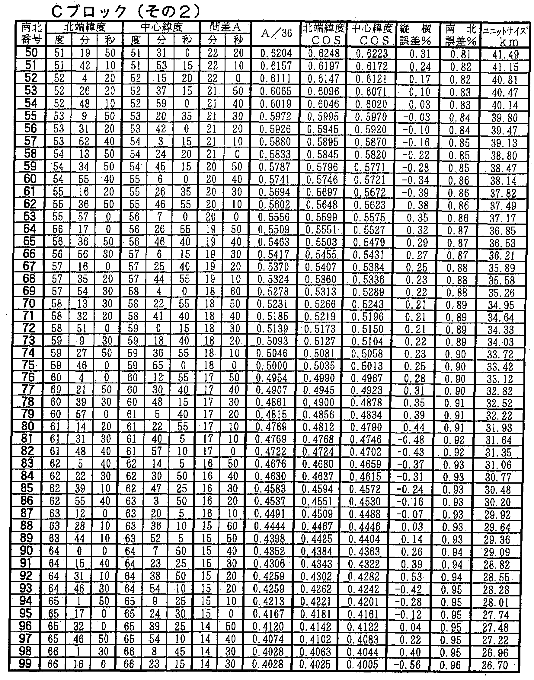


Claims
Priority Applications (3)
| Application Number | Priority Date | Filing Date | Title |
|---|---|---|---|
| EP04746475A EP1640941A1 (en) | 2003-06-27 | 2004-06-25 | Coordinate mutual converting module |
| JP2005511052A JP4384118B2 (en) | 2003-06-27 | 2004-06-25 | Coordinate conversion module |
| US10/562,002 US7676534B2 (en) | 2003-06-27 | 2004-06-25 | Coordinate mutual converting module |
Applications Claiming Priority (2)
| Application Number | Priority Date | Filing Date | Title |
|---|---|---|---|
| JP2003-185021 | 2003-06-27 | ||
| JP2003185021 | 2003-06-27 |
Publications (1)
| Publication Number | Publication Date |
|---|---|
| WO2005001794A1 true WO2005001794A1 (en) | 2005-01-06 |
Family
ID=33549636
Family Applications (1)
| Application Number | Title | Priority Date | Filing Date |
|---|---|---|---|
| PCT/JP2004/009006 WO2005001794A1 (en) | 2003-06-27 | 2004-06-25 | Coordinate mutual converting module |
Country Status (4)
| Country | Link |
|---|---|
| US (1) | US7676534B2 (en) |
| EP (1) | EP1640941A1 (en) |
| JP (1) | JP4384118B2 (en) |
| WO (1) | WO2005001794A1 (en) |
Cited By (9)
| Publication number | Priority date | Publication date | Assignee | Title |
|---|---|---|---|---|
| JP2006319379A (en) * | 2005-05-10 | 2006-11-24 | Hitachi Kokusai Electric Inc | Radio communication system |
| JP2008165096A (en) * | 2006-12-31 | 2008-07-17 | Toru Nishioka | Position information calculating method and program |
| JP2009109415A (en) * | 2007-10-31 | 2009-05-21 | Sanyo Electric Co Ltd | Navigation device |
| JP2011070574A (en) * | 2009-09-28 | 2011-04-07 | Hitachi Automotive Systems Ltd | Vehicle management system, server device, and navigation device |
| KR101499006B1 (en) * | 2013-11-08 | 2015-03-05 | 재단법인 한국형수치예보모델개발사업단 | Coordinates conversion method of conservative physical parameters from latitude-longitude coordinates system to rotated cubed-sphere coordinates system and hardware device performing the same |
| JP2016520903A (en) * | 2013-04-19 | 2016-07-14 | ワットスリーワーズ リミテッド | Method and apparatus for location and communication |
| JP2020061134A (en) * | 2018-10-05 | 2020-04-16 | パロ アルト リサーチ センター インコーポレイテッド | Hierarchical geographical naming |
| WO2020090510A1 (en) * | 2018-11-01 | 2020-05-07 | ソニーセミコンダクタソリューションズ株式会社 | Information processing device and method, and program |
| WO2023219014A1 (en) * | 2022-05-09 | 2023-11-16 | Ap Tech株式会社 | Encoding device and decoding device |
Families Citing this family (27)
| Publication number | Priority date | Publication date | Assignee | Title |
|---|---|---|---|---|
| US6751553B2 (en) * | 2000-06-14 | 2004-06-15 | Vermeer Manufacturing Company | Utility mapping and data distribution system and method |
| US7353034B2 (en) | 2005-04-04 | 2008-04-01 | X One, Inc. | Location sharing and tracking using mobile phones or other wireless devices |
| US9646415B2 (en) * | 2006-05-16 | 2017-05-09 | Underground Imaging Technologies, Inc. | System and method for visualizing multiple-sensor subsurface imaging data |
| US8089390B2 (en) | 2006-05-16 | 2012-01-03 | Underground Imaging Technologies, Inc. | Sensor cart positioning system and method |
| US8198980B1 (en) | 2007-09-21 | 2012-06-12 | Luger Dale J | Numeric geodesic locator |
| US7978132B2 (en) | 2008-03-14 | 2011-07-12 | Itt Manufacturing Enterprises, Inc. | GPS signal data converter for providing GPS signals to a plurality of connection ports |
| US20090254270A1 (en) * | 2008-04-02 | 2009-10-08 | O2Micro, Inc. | System and method for tracking a path of a vehicle |
| US20100138156A1 (en) * | 2008-12-01 | 2010-06-03 | Rubin-De-Cervens Bertrand | User Interactive GPS Locating Device |
| US8774468B2 (en) * | 2009-09-08 | 2014-07-08 | Schlumberger Technology Corporation | Dynamic shape approximation |
| EP3522081A1 (en) | 2009-12-04 | 2019-08-07 | Uber Technologies, Inc. | System and method for arranging transport amongst parties through use of mobile devices |
| US9230292B2 (en) | 2012-11-08 | 2016-01-05 | Uber Technologies, Inc. | Providing on-demand services through use of portable computing devices |
| WO2011106128A1 (en) * | 2010-02-25 | 2011-09-01 | Brennan Peter S | Location identification systems and methods |
| US20130132246A1 (en) * | 2010-12-06 | 2013-05-23 | Uber Technologies, Inc. | Providing a summary or receipt for on-demand services through use of portable computing devices |
| GB201117901D0 (en) * | 2011-10-18 | 2011-11-30 | Tomtom Int Bv | Map code: a public location encoding standard |
| US9342735B2 (en) * | 2011-12-01 | 2016-05-17 | Finding Rover, Inc. | Facial recognition lost pet identifying system |
| WO2013138388A1 (en) | 2012-03-12 | 2013-09-19 | Vermeer Corporation | Offset frequency homodyne ground penetrating radar |
| US9671233B2 (en) | 2012-11-08 | 2017-06-06 | Uber Technologies, Inc. | Dynamically providing position information of a transit object to a computing device |
| EP2932193A4 (en) * | 2012-12-12 | 2016-07-27 | Merton G Hale | Coding system for satellite navigation system |
| US9739133B2 (en) | 2013-03-15 | 2017-08-22 | Vermeer Corporation | Imaging underground objects using spatial sampling customization |
| US9264857B1 (en) * | 2013-10-15 | 2016-02-16 | Google Inc. | Compact codes for geographic locations |
| CN106716064B (en) * | 2014-09-16 | 2020-10-16 | 古野电气株式会社 | Ship-based surrounding information display device and ship-based surrounding information display method |
| CN104462860B (en) * | 2014-12-31 | 2017-12-22 | 宇龙计算机通信科技(深圳)有限公司 | The processing method and processing unit of location data |
| US10026506B1 (en) | 2015-02-06 | 2018-07-17 | Brain Trust Innovations I, Llc | System, RFID chip, server and method for capturing vehicle data |
| CN105101296A (en) * | 2015-07-14 | 2015-11-25 | 海能达通信股份有限公司 | Positioning information transmission method and communication device |
| JP7000296B2 (en) * | 2018-10-31 | 2022-01-19 | トヨタ自動車株式会社 | Demand forecast information display control method, display control device, and display control program |
| CN111061726B (en) * | 2019-11-18 | 2023-03-31 | 内蒙古师范大学 | Space vector data storage method based on point M value and coordinate system conversion system |
| CN111460071B (en) * | 2020-03-31 | 2023-09-26 | 北京百度网讯科技有限公司 | Deflection method, deflection device, deflection equipment and readable storage medium for high-precision map |
Citations (4)
| Publication number | Priority date | Publication date | Assignee | Title |
|---|---|---|---|---|
| JPH11184374A (en) * | 1997-12-20 | 1999-07-09 | Aisin Aw Co Ltd | Device and method for geographic coordinate representation, geometric information storage medium, device and method for geometric coordinate transformation, and storage medium storing program for geometric coordinate transformation |
| JP2000181345A (en) * | 1998-12-17 | 2000-06-30 | Toru Nishioka | World mesh code generating method and world mesh code |
| JP2002183263A (en) * | 2000-12-11 | 2002-06-28 | Asia Air Survey Co Ltd | Transportation business management system using new geocode |
| WO2002082014A2 (en) * | 2001-04-05 | 2002-10-17 | Patrick Segur | Measuring and locating system using bases three and nine and corresponding uses |
Family Cites Families (19)
| Publication number | Priority date | Publication date | Assignee | Title |
|---|---|---|---|---|
| JPH05164557A (en) | 1991-12-11 | 1993-06-29 | Fujita Corp | System for calculating coordinates of two-dimensional position of object to be measured |
| US5742297A (en) * | 1994-11-04 | 1998-04-21 | Lockheed Martin Corporation | Apparatus and method for constructing a mosaic of data |
| JPH08286257A (en) | 1995-04-18 | 1996-11-01 | Konica Corp | Data recorder for camera |
| JPH09305108A (en) * | 1996-03-11 | 1997-11-28 | Denso Corp | Method and device for specifying location, and method and device for displaying map using them |
| EP0798540B1 (en) * | 1996-03-25 | 2001-08-22 | MANNESMANN Aktiengesellschaft | Method to reference localized objects |
| JPH1114384A (en) * | 1997-06-24 | 1999-01-22 | Mitsubishi Electric Corp | Navigation system, position information code creating device for navigation system, information presenting system and its print medium |
| JP3045713B1 (en) * | 1998-12-09 | 2000-05-29 | 富士通株式会社 | Vehicle-mounted vehicle guidance device, communication server system, and alternative vehicle guidance system |
| US6961096B1 (en) * | 1998-12-25 | 2005-11-01 | Canon Kabushiki Kaisha | Apparatus for and method of converting location information, and computer program product that is used therefor |
| JP2002183149A (en) * | 2000-12-12 | 2002-06-28 | Denso Corp | Method and device for specifying spot, method and device for displaying map, spot reporting method, printed matter, computer-readable recoding medium, and unique code output method |
| JP2002183148A (en) * | 2000-12-12 | 2002-06-28 | Denso Corp | Method and device for specifying spot and its object |
| JP4572034B2 (en) | 2000-12-22 | 2010-10-27 | 株式会社富士通ソーシアルサイエンスラボラトリ | Computer-readable recording medium having recorded geographical alternative point determination system and geographical alternative point determination program |
| JP2002312368A (en) * | 2001-04-18 | 2002-10-25 | Nihon Kajo Publishing Co Ltd | Address position indication system |
| JP4275326B2 (en) * | 2001-05-16 | 2009-06-10 | 富士フイルム株式会社 | Imaging apparatus and position information detection system |
| JP2002351307A (en) * | 2001-05-30 | 2002-12-06 | Denso Corp | Method and device for map display |
| JP2003346285A (en) * | 2002-03-20 | 2003-12-05 | Vehicle Information & Communication System Center | Road information transmitter, method of transmitting road information, road information transmission program, road information receiver, method of receiving road information, and road information reception program |
| CN100449266C (en) * | 2002-08-09 | 2009-01-07 | 爱信艾达株式会社 | Map display device and program for map display |
| US7302343B2 (en) * | 2003-07-31 | 2007-11-27 | Microsoft Corporation | Compact text encoding of latitude/longitude coordinates |
| US7050903B1 (en) * | 2003-09-23 | 2006-05-23 | Navteq North America, Llc | Method and system for developing traffic messages |
| US7272500B1 (en) * | 2004-03-25 | 2007-09-18 | Avaya Technology Corp. | Global positioning system hardware key for software licenses |
-
2004
- 2004-06-25 WO PCT/JP2004/009006 patent/WO2005001794A1/en active Search and Examination
- 2004-06-25 EP EP04746475A patent/EP1640941A1/en not_active Withdrawn
- 2004-06-25 US US10/562,002 patent/US7676534B2/en active Active
- 2004-06-25 JP JP2005511052A patent/JP4384118B2/en active Active
Patent Citations (4)
| Publication number | Priority date | Publication date | Assignee | Title |
|---|---|---|---|---|
| JPH11184374A (en) * | 1997-12-20 | 1999-07-09 | Aisin Aw Co Ltd | Device and method for geographic coordinate representation, geometric information storage medium, device and method for geometric coordinate transformation, and storage medium storing program for geometric coordinate transformation |
| JP2000181345A (en) * | 1998-12-17 | 2000-06-30 | Toru Nishioka | World mesh code generating method and world mesh code |
| JP2002183263A (en) * | 2000-12-11 | 2002-06-28 | Asia Air Survey Co Ltd | Transportation business management system using new geocode |
| WO2002082014A2 (en) * | 2001-04-05 | 2002-10-17 | Patrick Segur | Measuring and locating system using bases three and nine and corresponding uses |
Cited By (9)
| Publication number | Priority date | Publication date | Assignee | Title |
|---|---|---|---|---|
| JP2006319379A (en) * | 2005-05-10 | 2006-11-24 | Hitachi Kokusai Electric Inc | Radio communication system |
| JP2008165096A (en) * | 2006-12-31 | 2008-07-17 | Toru Nishioka | Position information calculating method and program |
| JP2009109415A (en) * | 2007-10-31 | 2009-05-21 | Sanyo Electric Co Ltd | Navigation device |
| JP2011070574A (en) * | 2009-09-28 | 2011-04-07 | Hitachi Automotive Systems Ltd | Vehicle management system, server device, and navigation device |
| JP2016520903A (en) * | 2013-04-19 | 2016-07-14 | ワットスリーワーズ リミテッド | Method and apparatus for location and communication |
| KR101499006B1 (en) * | 2013-11-08 | 2015-03-05 | 재단법인 한국형수치예보모델개발사업단 | Coordinates conversion method of conservative physical parameters from latitude-longitude coordinates system to rotated cubed-sphere coordinates system and hardware device performing the same |
| JP2020061134A (en) * | 2018-10-05 | 2020-04-16 | パロ アルト リサーチ センター インコーポレイテッド | Hierarchical geographical naming |
| WO2020090510A1 (en) * | 2018-11-01 | 2020-05-07 | ソニーセミコンダクタソリューションズ株式会社 | Information processing device and method, and program |
| WO2023219014A1 (en) * | 2022-05-09 | 2023-11-16 | Ap Tech株式会社 | Encoding device and decoding device |
Also Published As
| Publication number | Publication date |
|---|---|
| JPWO2005001794A1 (en) | 2006-08-10 |
| JP4384118B2 (en) | 2009-12-16 |
| EP1640941A1 (en) | 2006-03-29 |
| US7676534B2 (en) | 2010-03-09 |
| US20060161346A1 (en) | 2006-07-20 |
Similar Documents
| Publication | Publication Date | Title |
|---|---|---|
| JP4384118B2 (en) | Coordinate conversion module | |
| US6525768B2 (en) | Positional camera and GPS data interchange device | |
| US8154440B2 (en) | GPS pathfinder cell phone and method | |
| EP1253400A2 (en) | Geographic location referencing system and method | |
| US20080278311A1 (en) | Advanced Emergency Geographical Information System | |
| RU2645918C1 (en) | Navigation system with geo-referencing (with top view) | |
| JP2001202577A (en) | Monitoring camera system for vehicle in accident | |
| Vahidnia et al. | Crowdsource mapping of target buildings in hazard: The utilization of smartphone technologies and geographic services | |
| JP2017010038A (en) | Survey type navigation system | |
| KR20010044730A (en) | System and the way how to provide realtime traffic information with motion pictures in mobile internet | |
| KR102512261B1 (en) | Location information sharing system and methods for the same | |
| KR101183519B1 (en) | System and method of generating poi information | |
| Saputra et al. | Implementation of Location Based Service on Monito ring System of Visually Impaired Position with A-GPS Method | |
| JP2019164350A (en) | Survey type navigation system | |
| JP2002163765A (en) | Geographical information processor | |
| Une et al. | Recent innovation of geospatial information technology to support disaster risk management and responses | |
| KR101217870B1 (en) | Method for creating or checking course information using smart phone with gps, wi-fi and smart phone a linear touch coordinates recognition and gis service using thereof | |
| JP2002108204A (en) | Map data distributing device and terminal device | |
| Kuboye et al. | Locating Global System for Mobile Communication (GSM) Base Stations Using Geographic Information System (GIS) | |
| Mick et al. | Remote sensing and the Mississippi high accuracy reference network | |
| Frančula et al. | Google earth | |
| Yagoub | Web-based and Mobile Geographic Information Systems (GIS) in the United Arab Emirates (UAE) | |
| González et al. | Information and Navigation System for Mountaineers: The Paramount Project | |
| Anai et al. | A Security Solution by 3D-GIS | |
| WO2004072924A1 (en) | Global notification/display/search system |
Legal Events
| Date | Code | Title | Description |
|---|---|---|---|
| AK | Designated states |
Kind code of ref document: A1 Designated state(s): AE AG AL AM AT AU AZ BA BB BG BR BW BY BZ CA CH CN CO CR CU CZ DE DK DM DZ EC EE EG ES FI GB GD GE GH GM HR HU ID IL IN IS JP KE KG KP KR KZ LC LK LR LS LT LU LV MA MD MG MK MN MW MX MZ NA NI NO NZ OM PG PH PL PT RO RU SC SD SE SG SK SL SY TJ TM TN TR TT TZ UA UG US UZ VC VN YU ZA ZM ZW |
|
| AL | Designated countries for regional patents |
Kind code of ref document: A1 Designated state(s): BW GH GM KE LS MW MZ NA SD SL SZ TZ UG ZM ZW AM AZ BY KG KZ MD RU TJ TM AT BE BG CH CY CZ DE DK EE ES FI FR GB GR HU IE IT LU MC NL PL PT RO SE SI SK TR BF BJ CF CG CI CM GA GN GQ GW ML MR NE SN TD TG |
|
| 121 | Ep: the epo has been informed by wipo that ep was designated in this application | ||
| WWE | Wipo information: entry into national phase |
Ref document number: 2005511052 Country of ref document: JP |
|
| ENP | Entry into the national phase |
Ref document number: 2006161346 Country of ref document: US Kind code of ref document: A1 |
|
| WWE | Wipo information: entry into national phase |
Ref document number: 2004746475 Country of ref document: EP Ref document number: 10562002 Country of ref document: US |
|
| WWP | Wipo information: published in national office |
Ref document number: 2004746475 Country of ref document: EP |
|
| DPEN | Request for preliminary examination filed prior to expiration of 19th month from priority date (pct application filed from 20040101) | ||
| WWP | Wipo information: published in national office |
Ref document number: 10562002 Country of ref document: US |