US8311558B2 - Real-time network node location system and method - Google Patents
Real-time network node location system and method Download PDFInfo
- Publication number
- US8311558B2 US8311558B2 US12/728,966 US72896610A US8311558B2 US 8311558 B2 US8311558 B2 US 8311558B2 US 72896610 A US72896610 A US 72896610A US 8311558 B2 US8311558 B2 US 8311558B2
- Authority
- US
- United States
- Prior art keywords
- location
- tag
- routers
- router
- directional
- Prior art date
- Legal status (The legal status is an assumption and is not a legal conclusion. Google has not performed a legal analysis and makes no representation as to the accuracy of the status listed.)
- Expired - Fee Related, expires
Links
Images


Classifications
-
- G—PHYSICS
- G01—MEASURING; TESTING
- G01S—RADIO DIRECTION-FINDING; RADIO NAVIGATION; DETERMINING DISTANCE OR VELOCITY BY USE OF RADIO WAVES; LOCATING OR PRESENCE-DETECTING BY USE OF THE REFLECTION OR RERADIATION OF RADIO WAVES; ANALOGOUS ARRANGEMENTS USING OTHER WAVES
- G01S5/00—Position-fixing by co-ordinating two or more direction or position line determinations; Position-fixing by co-ordinating two or more distance determinations
- G01S5/02—Position-fixing by co-ordinating two or more direction or position line determinations; Position-fixing by co-ordinating two or more distance determinations using radio waves
- G01S5/12—Position-fixing by co-ordinating two or more direction or position line determinations; Position-fixing by co-ordinating two or more distance determinations using radio waves by co-ordinating position lines of different shape, e.g. hyperbolic, circular, elliptical or radial
-
- G—PHYSICS
- G01—MEASURING; TESTING
- G01S—RADIO DIRECTION-FINDING; RADIO NAVIGATION; DETERMINING DISTANCE OR VELOCITY BY USE OF RADIO WAVES; LOCATING OR PRESENCE-DETECTING BY USE OF THE REFLECTION OR RERADIATION OF RADIO WAVES; ANALOGOUS ARRANGEMENTS USING OTHER WAVES
- G01S5/00—Position-fixing by co-ordinating two or more direction or position line determinations; Position-fixing by co-ordinating two or more distance determinations
- G01S5/02—Position-fixing by co-ordinating two or more direction or position line determinations; Position-fixing by co-ordinating two or more distance determinations using radio waves
- G01S5/0257—Hybrid positioning
- G01S5/0268—Hybrid positioning by deriving positions from different combinations of signals or of estimated positions in a single positioning system
-
- G—PHYSICS
- G01—MEASURING; TESTING
- G01S—RADIO DIRECTION-FINDING; RADIO NAVIGATION; DETERMINING DISTANCE OR VELOCITY BY USE OF RADIO WAVES; LOCATING OR PRESENCE-DETECTING BY USE OF THE REFLECTION OR RERADIATION OF RADIO WAVES; ANALOGOUS ARRANGEMENTS USING OTHER WAVES
- G01S5/00—Position-fixing by co-ordinating two or more direction or position line determinations; Position-fixing by co-ordinating two or more distance determinations
- G01S5/02—Position-fixing by co-ordinating two or more direction or position line determinations; Position-fixing by co-ordinating two or more distance determinations using radio waves
- G01S5/14—Determining absolute distances from a plurality of spaced points of known location
-
- H—ELECTRICITY
- H04—ELECTRIC COMMUNICATION TECHNIQUE
- H04W—WIRELESS COMMUNICATION NETWORKS
- H04W4/00—Services specially adapted for wireless communication networks; Facilities therefor
- H04W4/02—Services making use of location information
- H04W4/029—Location-based management or tracking services
-
- G—PHYSICS
- G01—MEASURING; TESTING
- G01S—RADIO DIRECTION-FINDING; RADIO NAVIGATION; DETERMINING DISTANCE OR VELOCITY BY USE OF RADIO WAVES; LOCATING OR PRESENCE-DETECTING BY USE OF THE REFLECTION OR RERADIATION OF RADIO WAVES; ANALOGOUS ARRANGEMENTS USING OTHER WAVES
- G01S13/00—Systems using the reflection or reradiation of radio waves, e.g. radar systems; Analogous systems using reflection or reradiation of waves whose nature or wavelength is irrelevant or unspecified
- G01S13/02—Systems using reflection of radio waves, e.g. primary radar systems; Analogous systems
- G01S13/06—Systems determining position data of a target
- G01S13/46—Indirect determination of position data
- G01S2013/466—Indirect determination of position data by Trilateration, i.e. two antennas or two sensors determine separately the distance to a target, whereby with the knowledge of the baseline length, i.e. the distance between the antennas or sensors, the position data of the target is determined
Definitions
- the invention relates to the field of wireless local area networks (WLAN), and more particularly, to a wireless system for locating mobile nodes within a monitored environment using a combination of RSSI (received signal-strength indicator) and sector discrimination using an array of limited-field-of-view antennas.
- WLAN wireless local area networks
- Wireless area networks are becoming more commonplace as wireless devices decrease in size, cost, and power consumption. As these devices slowly replace their wired counterparts in the areas of sensors and personal wireless devices, networks grow from a few devices to become facility-wide webs, where information really is only a few wireless hops away.
- the ZigBee wireless protocol built on the IEEE 802.15.4 standard, allows for the easy formation of such networks and is becoming increasingly prevalent in the creation of facility-wide mesh networks.
- the growth of these networks provides a plethora of information that can be analyzed to determine attributes of a node (or wireless network device) on the system. One of these attributes is the location of the node.
- RTLS Real-time location systems
- ToFA time-of-flight arrival
- RSSI received signal-strength indicator
- AoA angle of arrival
- a radio location system suitable for tracking objects over shorter distances is proposed in U.S. Pat. No. 5,119,104.
- a fixed array of receivers is distributed over the area and a transmitter is attached to the object to be tracked.
- Time-of-arrival measurements of transmitted signals at the distributed receivers are used to locate the object.
- this system does not take into account multi-path effects or signal propagation differences.
- ToF measurements typically require synchronous clock signals on all devices making them prohibitively complicated and expensive.
- Omni-directional RSSI systems use the relative power of received signals from a plurality of nodes to determine relative distances between the nodes. This is described in U.S. Pat. No. 6,963,289 with an RFID system.
- omni-directional RSSI-based systems do not solve the problem of multipath effects or singularities that arise from these multipath effects.
- the typical solution to this flaw is to use so-called “finger printing” systems that require extensive site surveys to create “heat maps” of the facility.
- the relative signal strengths measured in real-time are compared to the heat map to determine the most likely point of positioning. Additionally, these systems typically rely on past positions as a predictor of future position. This requires that the solution be real-time in nature. Privacy concerns as well as data management concerns arise with required real-time location tracking.
- AoA systems are currently too expensive due to the signal processing power needed to recognize small differences in phase.
- AoA systems are focusing on getting exact angles to measure location such as described in U.S. Pat. No. 7,233,799.
- a real-time network node location system includes: a tag to broadcast a plurality of signals; a plurality of routers each including at least one omni-directional antenna to receive at least a first part of the plurality of signals and at least one directional antenna to receive at least a second part of the plurality of signals, the plurality of routers to transmit information identifying signal strengths of the at least the first part and the at least the second part of the plurality of signals; and a location engine to: process at least the information identifying the signal strengths of the at least the first part of the plurality of signals to determine a position of location of the tag; and process at least the information identifying the signal strengths of the at least the second part of the plurality of signals to determine an area of location of the tag.
- a method for real-time determination of the location of a tag includes: (a) broadcasting, from the tag, a plurality of signals to a plurality of routers, each of the routers comprising one or more omni-directional antennas and one or more directional antennas; (b) receiving, by the one or more omni-directional antennas of each of the plurality of routers, at least a first part of the plurality of signals; (c) receiving, by the one or more omni-directional antennas of each of the plurality of routers, at least a second part of the plurality of signals; (d) transmitting, by each of the plurality of routers, to a location engine, information identifying signal strengths of the first part and the second part of the plurality of signals received; (e) processing, by the location engine, at least the information representing the signal strengths of the first part of the plurality of signals received by each router to determine a position of location of the tag; and (f) processing, by the location engine, at least the information representing the signal strengths of
- a system for determining a position of location of a tag includes: a plurality of routers each including at least one omni-directional antenna, the plurality of routers comprising at least three routers; and a location engine to: (a) determine for at least one router, from at least a part of signals sent by the one router and received by the at least one omni-directional antenna of each of at least one other of the routers, an average path loss of signal strength; (b) optimize, for at least the one router, multipath parameters in a radio-frequency signal propagation equation using the average path loss for each of the at least one other of the routers and known distance between the router and each of the at least one other of the routers; and (c) determine the position of location of the tag using at least the optimized multipath parameters.
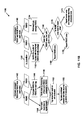
- FIG. 1 is a flow chart outlining the operation of a received signal-strength indicator location determination system, in accordance with an embodiment
- FIG. 2 is a flow chart outlining the operation of a real-time network node location system, in accordance with an embodiment
- FIG. 3 is a flow chart outlining the operation of a real-time network node location system in the context of the communicative entities associated therewith, in accordance with an embodiment
- FIG. 4 is a schematic of a real-time network node location system, including the communicative entities of FIG. 3 and the functionality associated therewith within a facility, in accordance with an embodiment
- FIG. 5 is a key for use with FIGS. 6-8 , in accordance with an embodiment
- FIG. 6 depicts a 90° directional antenna response in a real-time network node location system, in accordance with an embodiment
- FIG. 7 depicts sector establishment via the 90° directional antenna response of FIG. 6 , in accordance with an embodiment
- FIG. 8 depicts a directional antenna filtering system of a real-time network node location system, in accordance with an embodiment
- FIG. 9 is a flow chart outlining a method of calculating multipath parameters for use in determining an omni-directionally calculated position of a tag, in accordance with an embodiment
- FIG. 10 is a flow chart outlining a method of determining an omni-directionally calculated position of a tag, in accordance with an embodiment
- FIGS. 11A-11B are a flow chart outlining a method of determining an area of location of the tag, in accordance with an embodiment.
- FIG. 12 is a flow chart outlining a method of calculating a final position of a tag using omni-directionally calculated position and location area, in accordance with an embodiment.
- the system of the present invention utilizes the potential accuracy of an RSSI-based positional location finding system with the reliability of a system that provides sector or other area locating.
- the RSSI data may be collected using router omni-directional) (360°) antennas, while the sector or other area forming data may be collected by router antennas that provide a limited directional response.
- the limited responses of these antennas may create a sector-based or other area-based system that can be used to check the results of the position-finding RSSI system.
- the area locating system may also be based, at least in part, on RSSI or other signal strength determinations.
- FIG. 1 is a flow chart 100 outlining the operation of an RSSI location determination system.
- the RSSI location determination system may include a computer that may be connected to a wireless gateway, routers, and a smart wireless device or other tag.
- a request to locate a tag may be made.
- the location request may be made by the computer by a user's prompt at 102 or automatically at 104 , such as by polling initiated by a controlling program.
- the location engine may transmit the location request to the tag by wireless signal.
- the tag may then respond, at 108 , by broadcasting a “blast incoming” notification, notifying the routers to be ready to receive radio frequency (RF) blasts.
- RF blast incoming notification notifying the routers to be ready to receive radio frequency (RF) blasts.
- the tag broadcasts RF blasts to all of the routers.
- the routers receive the blasts and, at 112 , determine the average signal strength (e.g., average RSSI) of the RF blasts.
- each of the routers wirelessly transmits that average signal strength of the RF blasts to the location engine.
- the computer using the average signal strength of the RF blasts from each router, calculates the relative distance of the tag from each router.
- the computer uses those relative distances to calculate the position of the tag.
- position engine is also referred to herein as a “location engine.”
- the position engine or location engine may be a dedicated personal computer or any other computer and may be, in an embodiment, connected to a wireless gateway connecting to a system, such as any embodiment of a real-time network node location system described herein.
- the position engine or location engine may be placed on one or more routers and/or one or more tags.
- the position engine or location engine may be a single computer or a distributed computing system in which multiple computers collaborate over a network.
- the position engine or location engine may have software or firmware that runs a real-time network node location system such as described herein.
- the router may be a wireless device that is used to extend the wireless network, and to take signal strength and directional antenna measurements using omni-directional and directional antennas, respectively.
- the tag may be a smart wireless device, which may be powered by battery or by power harvesting techniques, and which may be placed on an object to be tracked if desired.
- the tag may be any other mobile or other device that can receive wireless signals, and that can transmit wireless signals that may be used to track the location of that device or area in which that device is located.
- a circle denotes the position engine 410
- a triangle denotes a router 420
- a diamond denotes the tag 430 .
- FIG. 2 is a flow chart 200 outlining the operation of an embodiment of a real-time network node location system, such as the real-time network node location system 400 of FIG. 4 .
- FIG. 3 is a flow chart 300 outlining the operation of a real-time network node location system in the context of the communicative entities associated therewith, in accordance with an embodiment.
- FIG. 4 is a schematic of a real-time network node location system 400 , including the communicative entities of FIG. 3 and the functionality associated therewith within a facility, in accordance with an embodiment. Though FIG.
- the first input into the system is, at 302 , the user's (or controlling program's) request for a location of a specific tag 430 .
- This message may be routed or otherwise transmitted to the location engine 410 .
- That location request at 302 may thus be made by the location engine 410 via a user's prompt at 302 , though in an embodiment, as in FIG. 2 at 204 , the location request may be made automatically, such as by polling initiated by the controlling program.
- the location engine 410 at this point may send the location request to the tag 430 that is specified. This is shown in FIG. 4 by the arrow extending from the location engine 410 to the tag 430 .
- this arrow does not follow the exact path of a real mesh network.
- Mesh networks typically contain short hops to route the message through the network. To simplify the figure, it is assumed that hopping occurs and the arrow is drawn between the source and the destination, though in other embodiments, the location request signal may be travel by other methods.
- the tag 430 may receive the location request at 307 .
- the tag 430 may broadcast to all routers 420 that it is ready to send signals to begin the process of determining the location of the tag 430 using signal strength, such as by trilateration.
- the signals the tag 430 sends are shown by the ring around the tag 430 labeled 308 .
- the routers 420 may, at 309 , receive this message and ready themselves to receive the signals with which to measure signal strength by enabling their omni-directional antennas.
- these signal strength communications originating at the tag 430 are called blasts because they represent a characteristic radio-frequency (RF) signal that may be currently meaningless except to identify the node from which they have come.
- the tag 430 may transmit information during the blast sequence.
- the tag 430 may release a designated number of blasts.
- the release of the blasts is shown in FIG. 4 by the ring around the tag 430 labeled 310 .
- This may allow routers 420 , at 312 , to collect the blasted RF signals and determine an RSSI for each signal.
- the routers 420 at 312 , take an average signal strength measurement from the RSSIs of all the signals received, though the routers 420 may not take that average in other embodiments.
- the RSSI values received, or average RSSI in an embodiment may be stored on each router 420 until all of the information is collected and the directional measurement, described below, is taken.
- the tag 430 may then, at 314 , broadcast a command to all routers 420 to switch over to the directional system, as shown in FIG. 4 by the ring labeled 314 .
- the routers 420 may then, at 316 , switch to receive information from the directional system by enabling their directional antennas.
- the tag 430 may blast a designated number of times. The blasts are shown in FIG. 4 by the fourth ring around the tag 430 labeled 318 .
- the routers 420 may, at 320 , receive and collect the blasts and determine directional RSSIs therefrom.
- the directional measurements may be highly reliable in an embodiment, and may be more reliable than the omni-directional RSSI measurements.
- the routers 420 may, at 322 , send both pieces of information, the omni-directional and directional signal strength measurements, back to the location engine 410 . If the omni-directional or directional RSSIs were not averaged by the router 420 , each router 420 may send all those RSSI values it collected to the location engine 410 . Alternatively, in the embodiment in which the router 420 averaged those RSSI values, the router 420 may send the averaged RSSI values to the location engine 410 .
- the omni-directional RSSI values may be turned into distance estimations between the routers 420 and the tag 430 .
- the location engine 410 may, for each router 420 , average the RSSI values the router 420 sent in the embodiment in which the router 420 did not already average the RSSI values.
- the location engine 410 may, at 324 , use the average signal strength of the RF blasts received by the omni-directional antenna from each router to calculate the relative distance of the tag 430 from each router 420 .
- These distance measurements may, at 326 , be used by the location engine 410 to calculate the position of the tag 430 , such as by trilateration or as described by the methods 900 and 1000 described below with respect to FIGS.
- the location engine 410 may compile the directional measurements to calculate a location area (referred to as P 2 in FIG. 3 ) in which the tag 430 is located, such as by the method described with respect to FIGS. 6-8 , the method 1100 described with respect to FIGS. 11A and 11B , or another method.
- the position of the tag 430 determined using the omni-directional RSSI values may then be compared to the determined location area of the tag 430 . If the position of the tag 430 calculated using the omni-directional RSSI values is within the location area, the position calculated using the RSSI values may be likely correct within meters. Conversely, if the position calculated using the RSSI values is outside of the location area, the location area may be provided as the location of the tag 430 , with a degree of error.
- the determined location area may be built on the directional responses of the directional antenna system, as will now be described with respect to FIGS. 5-8 , in which FIG. 5 is a key for use with FIGS. 6-8 .
- the omni-directional antenna response for RSSI measure shown in the key is not shown in FIGS. 6-8 , and merely demonstrates that the omni-directional antennas of the routers 420 in FIGS. 6-8 can receive blasts arriving from any angle, i.e., any direction.
- An example for creating such a real-time network node location system is an embodiment with a regular array of 90° antennas, and thus directional antennas with a 90° half-power beamwidth (HPBW). The responses of these antennas superimposed on an example floor plan are shown in FIG.
- FIG. 6 which depicts a 90° directional antenna response in a real-time network node location system, such as the real-time network location system 400 , in accordance with an embodiment.
- the directional antennas create overlapping areas of coverage. This serves to create sectors of coverage that can be seen by the checkerboard pattern shown in FIG. 7 , which depicts sector establishment via the 90° directional antenna response of FIG. 6 , in accordance with an embodiment.
- FIG. 7 depicts sector establishment via the 90° directional antenna response of FIG. 6 , in accordance with an embodiment.
- These squares of coverage are created by simple comparison. From the overhead view of FIG. 7 , each router 420 (using the 90° directional antenna) covers all squares to its right and below, such that each router 420 is positioned at the upper left corner of the upper left square it covers.
- the router 420 at the upper left corner of the square C 2 covers, or “sees,” the squares C 2 , C 3 , C 4 , C 5 , D 2 , D 3 , D 4 , and D 5
- the router 420 at the upper left corner of the square C 4 covers, or “sees,” only the squares C 4 , C 5 , D 4 , and D 5
- the routers 420 may, in an embodiment, also cover some of the area outside that 90° half-power beamwidth (HPBW), though the drop-off in reception outside that HPBW may be, in an embodiment, significant.
- methods may be used to determine the location and sector of the tag, such as described below with respect to methods 900 - 1200 of FIGS. 9-12 , respectively.
- each router 420 may determine a signal strength measurement from its omni-directional antenna and the directional antenna. These two measurements may be compared, such as by the location engine 410 , to determine whether the tag 430 is inside the 90° HPBW of the directional antenna. This determination may be made for each router 420 and a binary decision may be made as to whether or not the router “sees” the tag 430 . As is shown in FIG.
- routers 420 that are not at the upper left of certain squares (A 1 , A 2 , A 3 , B 1 , B 2 , B 3 , C 1 , C 2 , C 3 ) are likely to see the tag 430 , whereas all other routers 420 (at the upper left of a shaded square) are not. Additionally, the router 420 at the upper left corner of the square C 3 is the highest router to communicate with the tag 430 . Therefore, the tag 430 can be said with some reliability to be in or near the square C 3 .
- the directional antenna of a router may receive blasts outside its HPBW, but the received signal strength of the blasts may be dropped off (or significantly dropped off in an embodiment) outside that HPBW.
- additional routers may “see” the tag, so the returned square in which the tag is determined to be located may be merely near the actual square of location. The possibility of that error in this embodiment may be reduced, such as by using the methods 900 - 1200 of FIGS. 9-12 , respectively, to determine the final position of location of the tag 430 . Those methods are described below.
- the aforementioned systems and methods detailed above are only examples of a more reliable location determination based, at least in part, on a directional antenna system. Many different angles can be substituted for the 90° system detailed above in various embodiments.
- the HPBWs of the directional antennas of the routers may be the same or differ between one or more routers. It is further to be understood that the square pattern shown in FIGS. 6 , 7 , and 8 is only an embodiment of the various shapes that may be used as sectors, and thus used as areas of location each associated with a router.
- the HPBWs of the directional antennas of one or more of the routers may be oriented in different directions.
- the area of location associated with each router may be considered an area within the HPBW of its directional antenna. That area of location may be bounded by a selected distance, e.g., radius, from the router, such as the distance to which the nearest router within that HPBW is located, the distance to the perimeter of the selected search area, or any other selected distance or distances. In those embodiments, the areas of location associated with the routers may overlap.
- the determined area of coverage may be considered to be associated with any router that “sees” the tag, as described herein, or the router, among all the routers that “see” the tag, that has the highest average RSSI determined from blasts received with its directional antenna.
- Such an embodiment may have its area of location and final position calculated, if desired, using the methods 900 - 1200 of FIGS. 9-12 , respectively.
- the HPBWs of the directional antennas of the routers in any of the embodiments herein, such as in the embodiments of one or more of FIGS. 2-8 , for example, may be at least substantially 80°, and in another embodiment, at least substantially 85°.
- some directional antennas may be able to receive blasted signals outside of their HPBWs. Those antennas may not have a significant drop-off in the ability to receive those signals before the blasted signals are a number of degrees, such as up to about 10° in an embodiment, outside their HPBWs.
- the HPBWs of those antennas may be substantially 80° or greater, up to substantially about 90°, and yet still operate to receive blasted signals as in those embodiments of FIGS. 2-8 or in other embodiments herein.
- the HPBWs of the directional antennas of the routers may be at least about 80° or substantially about 90° and oriented in the same direction, but the routers may be variously positioned such that areas of location of those routers vary.
- the routers in those embodiments may be aligned such that one or more of the columns A-B and/or rows 1 - 5 have different widths.
- FIG. 9 is a flow chart outlining a method 900 of calculating multipath parameters for use in determining an omni-directionally calculated position of a tag (e.g., tag 430 ), such as described in the method 1000 of FIG. 10 below, in accordance with an embodiment.
- the method 900 may calculate the multipath parameters, as described below, without use of a tag.
- the method 900 may be used, in an embodiment, in a real-time network node location system, such as described herein with respect to FIGS. 2-8 , including the real-time network node location system 400 , for example.
- the method 900 may be used, in an embodiment, by the location engine 410 described herein or another location engine.
- the multipath parameters may be used in the method 900 , in an embodiment, in one or more equations to approximate distances and determine a position of location of a tag or router from signal strength measurements determined by the omni-directional antenna of one or more routers, such as one or more routers 420 described herein.
- the one or more equations involve two multipath parameters, a path loss exponent (n) and a path loss constant (A).
- a location engine sends a location request, initiated by a user prompt or automatically by polling, for example, to a specific router.
- the location request may be sent via short hops between routers, instead of directly, to the specific router.
- the specific router may receive the location request and send a designated number of blasts for the other routers to receive by their omni-directional patterns that are envisioned.
- the routers 420 may be set in different locations and may have directional antennas with various fields of view, and thus various areas of coverage.
- the specific router that received the location request at 902 may broadcast to the other routers, such as at 308 of FIG. 3 , for example, that it is ready to send blasts to the other routers for use in measuring omni-directional signal strength.
- the other routers may then enable their omni-directional antennas. In another embodiment, however, the other routers may already have their omni-directional antennas enabled.
- One or more other routers may, at 906 , receive and collect the blasts (RF signals) with their omni-directional antennas and each determine a signal strength, such as an RSSI, for each of those received signals.
- a signal strength such as an RSSI
- the other routers that receive the blasts may take an average signal strength measurement from the RSSIs of all the signals received.
- Those determined omni-directional RSSIs, or average RSSI in an embodiment may be stored on those other routers until all of the information is collected and, as described below, the directional measurement is taken.
- the router (that had sent the blasts at 904 ) or the location engine may then, at 908 , broadcast a command to all other routers to be ready to receive blasts by their directional antennas, and thus to switch over to the directional system.
- the other routers may, at 908 , enable their directional antennas.
- the router may, at 910 , blast a designated number of times.
- One or more other routers may, at 912 , receive and collect the blasts (RF signals) with their directional antennas and each determine a signal strength, such as an RSSI, for each signal.
- RF signals radio frequency
- the other routers that received the blasts may, at 914 , send information identifying both signal strength measurements, e.g., omni-directional and directional RSSIs, to the location engine.
- each of the other routers may send a signal identifying the average omni-directional and directional RSSIs to the location engine.
- each of the other routers that received the blasts may, at 914 , also send a signal that identifies its position, e.g., the three-dimensional position (x, y, z), or some identification of that other router if the location engine already has the positions of the routers stored or can access them.
- only the other routers on the same floor (of a building in which the routers may be located) as that of the blasting router may be considered in the method 900 , and thus only the two-dimensional position of those other routers may be sent if not already stored on, or otherwise accessible by, the location engine.
- the blasting router may send, or may have sent at any time, a signal to the location engine providing information identifying its three-dimensional or two-dimensional position if that information is not already stored on, or otherwise accessible by, the location engine.
- the location engine may receive the RSSIs the other routers transmitted at 914 .
- the location engine may receive those RSSIs via a ZigBee coordinator if the system is operative in compliance with the ZigBee protocol.
- the location engine determines if at least three of the other routers received the blasts, and thus whether at least three other routers sent information identifying RSSIs and possibly their position, as described above at 914 , to the location engine. If not, then, at 920 , the location engine may return to 902 to send a new location request. If at least three other routers did respond and send the aforementioned information at 914 , then, at 922 , the location engine may keep the received position, omni-directional RSSIs, and directional RSSIs.
- 918 , 920 , and 922 is otherwise performed as described above, but the determination and subsequent associated function is performed with respect to whether at least one other router (as opposed to at least three other routers) received the blasts.
- the location engine filters out (discards) outlying or very low omni-directional RSSIs.
- the location engine may filter out omni-directional RSSIs that were, for each other router, much lower or otherwise much different (e.g., off more than one standard deviation or another determined difference) in omni-directional RSSI value than the rest of the omni-directional RSSI values collected by that other router.
- the average RSSI for each router may thus be considered the average of the RSSIs of all blasts received with the omni-directional antenna of that router and not filtered out in one embodiment, though in another embodiment, the average may be that of all of those RSSIs for that router.
- the location engine may, if the omni-directional RSSIs were not separately averaged by each other router, as described above, average the omni-directional RSSIs for each router.
- 924 and 926 may be performed to filter outlying or very low directional RSSIs and then average the remaining directional RSSIs for each other router.
- multipath parameters may be optimized in various embodiments using a desired optimization algorithm or algorithms, such as an RF signal propagation model equation, which is considered herein to encompass one or more equations.
- multipath parameters are optimized to best fit an RF propagation model equation, such that the router that sent the blasts is calculated close to its actual position, such as close as possible to its actual position, subject to the constraints of that optimization process.
- the multipath parameters may be a path loss exponent (n) and a path loss constant (A) that accounts for system losses.
- L is the average path loss of signal strength from the signals the blasting router sent at 904 to the signals received by the omni-directional antenna of the other router. Since the signal strength (and thus average signal strengths) of the blasts are known, and the average omni-directional RSSI from each other router has been determined in the method 900 , e.g., at 926 , the average path loss L may be the difference between those average signal strengths.
- the path loss exponent n and path loss constant A may be optimized by repeatedly calculating a distance d by running the path loss equation above, using a trial path loss exponent n and trial path loss constant A, with respect to each other router that received the blasts.
- the calculated distance d and the error in that distance with respect to the actual, known distance between each blasting router and blast-receiving router may then be applied in the method 1000 , as described below with respect to FIG. 10 , to calculate a position of the blasting router.
- the average error between the calculated distances d and actual distances between the blasting router and each of the other, blast-receiving routers may be determined and applied in the method 1000 , such that the average error is used as the error in the distance between all routers.
- the process at 928 may be repeated, each time with a new trial path loss exponent n and path loss constant A until the error in the calculated position of the blasting router is minimized and n and A are thus optimized, subject to the constraints of that optimization process.
- That optimized path loss exponent n and optimized path loss constant A may be used in the combined method of methods 1000 - 1200 described below with respect to FIGS. 10-12 , respectively, in determining a final position of a tag 430 or other tag.
- the final position may be close, or as close as possible, subject to the constraints of any of the embodiments of that combined method, to the actual position of the tag.
- the optimization process described above may be performed and for each trial path loss exponent n and path loss constant A, the calculated distances d and errors (or average error) with respect to the actual distances may be used in the method 1000 as described above. But in this embodiment, the method 1100 of FIGS. 11A and 11B may be additionally applied by the location engine in determining a position of the blasting router. Again, the process in this embodiment may be repeated, each time with a new trial path loss exponent n and path loss constant A, until the error in the calculated position of the blasting router is minimized and the path loss exponent n and path loss constant A are thus optimized.
- the method 900 from 902 to 926 may be repeated, which may include the process described below with respect to 930 and 932 , each time such that a different router will send blasts to the other routers, and appropriate data will be collected and processed as described.
- the embodiments described above at 928 may then be used to optimize the path loss exponent n and path loss constant A separately for each blasting router with respect to either all blast-receiving routers or only the blast-receiving routers within a selected region.
- the path loss exponent n and path loss constant A may be different for each router.
- the method 900 from 902 to 926 may be repeated after determining at 930 that all routers have not been located and then initiating a location request at 932 , each time with a different router. But, at 934 , the embodiments at 928 may then be used to optimize the path loss exponent n and path loss constant A for all the blasting routers together or all the blasting routers together in a specified region. In that case, the optimization process may minimize, in an embodiment, the sum of the square of the errors in the calculated position and actual distance between every specified router with respect to each other specified router. In that case, the path loss exponent n and path loss constant A may be the same for all specified routers. However, any other optimization process may be used as desired.
- the path loss equation above may be applied to optimize the path loss exponent n and path loss constant A to best fit an RF propagation model equation, such that the router that sent the blasts is calculated close to its actual distance, such as close to its actual position as possible, subject to the constraints of that optimization.
- the average path loss L may be the difference between those average signal strengths and may be known.
- the path loss exponent n and path loss constant A may be optimized by repeatedly calculating a distance d by running the path loss equation above, using a trial path loss exponent n and trial path loss constant A, with respect to each other router that received the blasts.
- the sum of the squares of the errors between each calculated distance d and the actual, known distance between the blasting router and blast-receiving router may be determined. That process at 936 may be repeated, each time with a new trial path loss exponent n and path loss constant A, until the resulting sum of the squares of the distance errors has been minimized, and thus the path loss exponent n and path loss constant A has been optimized.
- Other optimization processes may be used as desired.
- the method 900 from 902 to 926 may be repeated, along with 930 and 932 as described above, each time such that a different router will send blasts to the other routers, and appropriate data will be collected and processed as described.
- the path loss exponent n and path loss constant A can be optimized separately for each blasting router with respect to either all blast-receiving routers or only the blast-receiving routers within a selected region.
- the path loss exponent n and path loss constant A may be different for each router.
- the path loss exponent n and path loss constant A can be optimized for all the routers together in a region or all the routers. In that case, in an embodiment, the sum of the squares of the errors for all the specified routers with respect to all those routers may thus be minimized.
- the path loss exponent n and path loss constant A may thus, in that case, be the same for all specified routers. However, any other optimization process may be used as desired.
- the path loss constant A may be held constant throughout the optimization process.
- the path loss constant A may be chosen, then left unchanged such that only the path loss exponent n is changed during the optimization process. That process is still considered, in an embodiment, optimizing multipath parameters.
- the determined path loss exponent n and path loss constant A may be used by the location engine to locate a tag 430 or other tag, as described below in the processes 1000 - 1200 of FIGS. 10-12 , respectively, for the entire search area or individual sectors or another area.
- FIG. 10 is a flow chart outlining a method 1000 of determining an omni-directionally calculated position of a tag, in accordance with an embodiment.
- the method 1000 may be used, in an embodiment, in a real-time network node location system, such as described herein with respect to FIGS. 2-8 , including the real-time network node location system 400 , for example.
- the method 1000 may be used, in an embodiment, by the location engine 410 and with one or more routers 420 and a tag 430 .
- the process at 1002 through 1026 may proceed the same as or similarly to the method 900 of FIG. 9 from 902 through 926 , respectively, except that in the method 1000 , a tag, instead of a router, sends the blasts. If desired, then additionally at this time, at 1023 , the location engine may determine a sector or other area in which the tag is located, such as by trilateration or as described below with respect to the method 1100 of FIGS. 11A and 11B .
- the multipath parameters determined by the method 900 of FIG. 9 may be input at 1028 into the RF signal propagation model equation or equations at 1030 .
- the location engine may calculate an approximate distance between the tag and each router that received the blasts from the tag using an RF signal propagation model equation.
- the distance d from each router to the tag may be calculated.
- the final errors in the distance between that router and the other routers that received its blasts or a final average error in the distance between that router and the other routers, as determined in the method 900 of FIG. 9 may be applied, at 1032 , in a probability density function (e.g., having a normal distribution) schematically to a search area array in a ring around that router. Peaks in the ring may be present at array positions representing the calculated tag radial distance.
- a probability density function e.g., having a normal distribution
- a density function may be positioned perpendicular to the ring and may have a width related to the aforementioned final distance error or average distance error, such as double the error width or another width. This process at 1032 may be repeated for all routers, and their resulting rings with peaks and density function may be superimposed in the search area array. If needed or desired, the search area array, which may represent a designated search area, may, before at 1034 , have all values set to zero. In this embodiment, the routers and tag may be located on the same floor, though in another embodiment in which the tag and routers are not all located on the same floor, a probability density function for determining three-dimensional position of the tag or another desired equation may be used.
- the final errors for each router or average error applied at 1032 above may be determined at 928 , 934 , or 936 of FIG. 9 , for example, or by the same or another method that determined final errors or a final average error in distances between the blasting router and blast-receiving routers when the path loss exponent n and path loss constant A were optimized in the method 900 .
- the location engine may search the search area array to find the overall peak value.
- the location engine may determine the location of that peak value as the omni-directionally calculated position of location of the tag.
- the methods 900 - 1200 of FIGS. 9-12 may not all be performed to determine the final position of location of the tag. In this embodiment, only the methods 900 - 1000 of FIGS. 9-10 may be performed, and the position of location determined at 1038 may be considered the final position of location of the tag.
- the search area may be all or a portion of the total search area. If the search area is selected to be just a portion of the total search area, the method may be limited to the routers positioned within that selected portion.
- FIGS. 11A and 11B are a flow chart outlining a method 1100 of determining an area of location of the tag, in accordance with an embodiment.
- the method 1100 may be used, in an embodiment, in a real-time network node location system, such as described herein with respect to FIGS. 2-8 , including the real-time network node location system 400 , for example.
- the method 1100 may be used, in an embodiment, by the location engine 410 and with respect to one or more routers 420 and a tag 430 .
- the method 1100 may proceed the same or similar as that of the method 900 of FIG. 9 from 902 through 916 , except that in the method 1100 , a tag, instead of a router, sends the blasts to all of the routers.
- the location engine may receive, from each router, a position ((x,y,z) for multi-floor positioning or (x, y) for single floor positioning), omni-directional RSSIs, and directional RSSIs.
- that information may have already been provided at 1023 of FIG. 9 by the three or more routers that responded, at 1018 , to the location request.
- the routers may, in an embodiment, average the omni-directional RSSIs and average the directional RSSIs and send those average RSSIs to the location engine.
- the location engine filters out (discards) outlying or very low omni-directional and directional RSSIs.
- the location engine may filter out omni-directional and directional RSSIs that were, for each router, much lower or otherwise much different (e.g., off more than one standard deviation or another determined difference) in omni-directional and directional RSSIs than the rest of the omni-directional and directional RSSIs collected by that router.
- the location engine may average, for each router, the omni-directional RSSIs and directional RSSIs that were not filtered out.
- the location engine may use the router positions, average omni-directional and directional RSSIs, and the angular orientations of the routers in one of multiple embodiments of a method to determine a sector or other area, within the search area, in which the tag is located.
- the angular orientations of the routers may be known and defined by the half-power beamwidths (HPBW) of the directional antennas connected to the routers.
- HPBWs of the directional antennas of the routers may be 90° and oriented in the substantially the same direction, such as shown and described with respect to FIGS. 6-8 .
- the ability of the directional antennas to receive blasts may drop off (significantly in an embodiment) outside their HPBWs.
- the directional antennas may still receive blasts outside the HPBW, and the combined method of methods 900 - 1200 of FIGS. 9-12 , respectively, may reduce the likelihood of determining an incorrect area of location (e.g., a square in the embodiment of FIGS. 6-8 or another area of location such as described herein) of the tag.
- an incorrect area of location e.g., a square in the embodiment of FIGS. 6-8 or another area of location such as described herein
- the location engine may, at 1142 , for each router, prepare to make comparisons between the average omni-directional and/or directional RSSIs (labeled RSSIO and RSSID in FIG. 11A ).
- the location engine may compare the average omni-directional and directional RSSIs for each router.
- the location engine may rank the areas of location by ranking the associated routers by increasing difference in average omni-directional and directional RSSI. Thus, for example, the least such difference has the highest rank.
- the routers receive a value from zero to X minus one, with zero as the highest rank and Xminus one as the lowest, where X equals the number of routers that received blasts to determine both omni-directional and directional RSSIs and were not discarded.
- An area of location may be determined as desired by placement of the routers, such as shown in FIGS. 6-8 , for example, or otherwise as discussed.
- the routers may have directional antennas having varied HPBWs that may or may not all be oriented in substantially the same direction.
- the area of location associated with each router may be some selected area within its HPBW, may differ with respect to the area of location of other routers, and may overlap with the area of location associated with one or more other routers.
- a tag may be positioned within the directional area of location of that router.
- the omni-directional RSSI between the tag and this router may be minus 40 dBm (power in decibels referenced to one milliwatt), for example.
- the directional RSSI might be minus 32 dBm, since there may be a gain difference in this direction of 8 dBm, increasing the directional RSSI by 8 dBm. If that tag had been outside of the directional antenna's HPBW, but the directional antenna still received that signal, the directional RSSI might have been minus 42 dBm. This is because there may be an 8-dBm difference in antenna gain between the omni-directional antenna and directional antenna.
- the directional average RSSI may be attenuated by 8 dBm, so if the tag is positioned close to a router and within that router's area of location, the omni-directional and directional RSSI determinations from the received blasts would be about minus 40 dBm, whereas if the tag were out of the area of location, the omni-directional RSSIs may still be minus 40 dBm while the directional RSSIs would be about 50 dBm.
- those dBm numbers and the extent of attenuation will differ. This attenuation can be done, for example, on the location engine in hardware or in software. This attenuation may be excluded in other embodiments.
- some routers may not receive directional RSSIs, or may receive very low directional RSSIs, if the blasts from the tag to those routers were not transmitted within the HPBW.
- some routers may have very large differences between their average omni-directional and directional RSSIs, and their associated areas may be discarded, in an embodiment, as possible areas in which the tag may be located.
- the areas of location of routers having such differences of at least 3 dBm are discarded.
- such differences of at least between 8 and 10 dBm are discarded.
- the minimum difference in dBm for discarding may be selected as desired.
- the routers are ranked by average omni-directional RSSI, such that the highest RSSI has the highest ranking
- the routers may receive a value from zero to X minus one, with zero as the highest rank and Xminus one as the lowest, and where X equals the number of total routers that received blasts to determine both omni-directional and directional RSSIs and were not discarded.
- the routers from each ranked list i.e., the ranked routers determined at 1146 and the ranked routers determined at 1148 , are compared.
- the overall top ranked router (and associated area of location) combined between both lists is returned as the area of location, associated with that router, in which the tag is located.
- the overall top ranked router is determined to be the router having the lowest sum between the ranked lists, e.g., a router with zero at 1146 and one at 1148 for a total of one when no other router has a sum less than two. If two routers tie for the lowest sum, the areas of location associated with those routers may be returned as two of the possible areas of location.
- the location engine may, at 1160 , for each router, compare the average omni-directional and directional RSSIs.
- a cluster of routers with each router identified by an inputted position (e.g., (x, y)) at 1161 , having the highest omni-directional RSSI average is identified.
- a cluster may be that router and the eight most closely surrounding routers.
- the router with the maximum average directional RSSI, and its associated area is determined.
- the location engine determines if that area associated with the maximum average directional RSSI is within the perimeter of the cluster, e.g., within the four squares, in FIG. 6 for a router, that its eight most closely surrounding routers surround, or, in an embodiment, overlaps that area, or, in another embodiment, is within the areas of location of any of the eight surrounding routers. If so, then that area associated with the maximum average directional RSSI is reported, at 1168 , as the area in which the tag is located. If not, then, at 1170 , if that area associated with the maximum average directional RSSI is closest to that cluster, then that area is reported, at 1172 , as the area of location of the tag. If that area is not close to the cluster, then at 1174 , the cluster area is reported as the area in which the tag is located and a message reports that there is a directional error.
- FIG. 12 is a flow chart outlining a method 1200 of determining a final position of a tag using the omni-directionally calculated position and location area, in accordance with an embodiment.
- the omni-directionally calculated position at 1202 and location area at 1204 are input for comparison.
- the location engine may, at 1206 , compare the omni-directional position of the tag determined by using the methods 900 - 1000 of FIGS. 9-10 , respectively, and the sector or other area of location in which the tag is located as determined by the method 1100 of FIG. 11 . If that omni-directional position falls within that area of location, then, at 1208 , that omni-directional position is given as the final position of location of the tag.
- the methods 900 - 1100 of FIGS. 9-11 may be repeated, and then the method 1200 may be repeated.
- Other methods may be used, as desired, to determined the final position of location of the tag
- the areas of location associated with those routers may be returned as two of the possible areas of location. In that case, then at 1206 , both of those areas of location can be compared with the omni-directional position of location at 1206 . If that omni-directional position falls within either area of location, then, at 1208 , that omni-directional position may be given as the final calculated position of the tag. If that omni-directional position does not fall within either area of location, then, at 1210 , the methods 900 - 1100 of FIGS. 9-11 , respectively, may be repeated, and then the method 1200 may be repeated.
- the omni-directional and directional antennas in an embodiment, may be embodied in a single device.
- those antennas may be considered separate devices or just a single device that can switch its function between that of an omni-directional and directional antenna.
- An embodiment of such a single device is a smart antenna.
- the signals sent in the form of blasts by a router may be sent as a single set of blasts that may be received by both the omni-directional and directional antenna of each router. In that case, the omni-directional and directional antennas may both be enabled.
- a single set of blasts may be sent, but at least a first part of those signals may be received by the omni-directional antenna, and at least a second part may be received by the directional antenna.
- the first part of the signals may be different than, the same, or partly the same (i.e., some but not all signals are the same) as the second part of the signals.
- Receiving “at least” a first or second part of the signals means receiving one or more, up to all, of the total blast signals broadcast by the router or tag.
- the omni-directional antenna and/or directional antenna may be already enabled, and thus may not need to receive a command, such as from the tag or router, to enable either antenna.
- each router may have more than one omni-directional antenna and/or more than one directional antenna.
- the blasts may be received by each of the omni-directional and/or directional antennas.
- each omni-directional antenna and each directional antenna of each router may receive a part of the blast signals sent from a router (e.g., in the method 900 of FIG. 9 ) or a tag, as described herein.
- the first part may be different for each omni-directional antenna and the second part may be different for each directional antenna.
- those antennas may each receive at least a part of the blasts, and those parts may be different, the same, or partly the same.
- the two or more directional antennas may each determine RSSIs and send those RSSIs to the location engine.
- the location engine may average the RSSIs for each of the two or more directional antennas.
- the location engine may then treat, such as in any of the embodiments herein, each average RSSI and associated directional antenna from one router as belonging to a different router having the same location.
- the location engine may use the omni-directional RSSIs with each such “different router” (i.e., with each directional antenna on one router being treated as another router) in any of the determinations herein, such as, for example, determining a location of a tag through the combined methods 900 - 1200 of FIGS. 9-12 , respectively.
- the location engine may determine one average for all the RSSI readings combined for all the directional antennas and treat that average as belonging to just a single router.
- a router has two or more omni-directional antennas. Those antennas may each receive at least a part of the blast signals, and those parts may be different than each other, the same, or partly the same.
- each omni-directional antenna may determine RSSIs for the blast signals and send those RSSIs to the location engine.
- the location engine determines one average for all the RSSI determinations for all omni-directional antennas of the one router or, in another embodiment, the location engine averages the RSSI readings from one or more, but not all, of the omni-directional antennas.
- the location engine may then use that average omni-directional RSSI in any of the determinations herein, such as, for example, determining a location of a tag through the combined methods 900 - 1200 of FIGS. 9-12 , respectively.
- the location engine determines an average RSSI for each of those antennas and, as with one embodiment of a router having multiple directional antennas as described above, treats each average RSSI as belonging to an omni-directional antenna of a different router in any determination herein.
- Embodiments described herein may reduce error affecting signal travel indoors, and may thus improve the accuracy of locating a tag in buildings and other structures.
- the present invention includes a wireless real-time location system that uses signal strength and angle information to calculate mobile device location, the system including (a) a plurality of stationary wireless network routers that utilize omni-directional and directional antennas to measure signal strength from mobile devices and to identify an angle that mobile devices are from each router; (b) mobile devices to be tracked capable of broadcasting signals to said stationary wireless network routers for signal strength measurements and angle determination; and (c) a network node acting as a location processor that receives signal strength and angle information from stationary routers of known locations and subsequently computes mobile device location.
- the stationary wireless network routers may use multiple omni-directional antennas or multiple directional antennas or both.
- a phased array of antennas may be used to form a directional beam.
- the signal strength measurements may be used to determine the RSSIs. Any communication signals transmitted by the mobile devices may be used by stationary routers for signal strength measurements and angle determination.
- the location processing may occur on the mobile devices upon receipt of signal strength and angle information from stationary routers. The location processing may occur on designated stationary routers in a distributed fashion.
- the location processor which in an embodiment may be the location engine as described herein, may be operative for processing the maximum likelihood estimation for determining location probabilities using signal strength information.
- the location processor may be operative for processing the maximum likelihood estimation for determining location probabilities using measurements from directional antennas.
- Mobile devices may be located automatically according to a regular time cycle or a regularly occurring event. Mobile devices may be located when polled by a physical stimulation on the mobile device or a wireless signal sent to a mobile device from another network device.
- the network devices may communicate and may be operative in compliance with the IEEE 802.15.4 standard.
- the network devices may communicate and may be operative in compliance with the ZigBee protocol.
- Physical stimulation on the mobile device may come from the press of an actuator (e.g., button) or may be information from a connected sensor.
- an actuator e.g., button
- Angle determination of the directional antennas may be defined by the half-power beamwidths (HPBWs) of the antennas connected to stationary wireless network routers.
- HPBW half-power beamwidths
- the HPBW may be ninety degrees or another angle.
- a wireless real-time location system may include (a) a plurality of stationary wireless network routers that utilize omni-directional antennas for typical network communication as well as to measure the signal strength from mobile devices; (b) directional antennas individually connected to said stationary wireless network routers and activated to measure the signal strength from mobile devices to determine direction; (c) mobile devices to be tracked that broadcast signals to said stationary routers for signal strength measurements and directional antenna readings; and (d) a network node acting as a location processor that receives signal strength measurements resulting from said omni-directional antennas, signal strength measurements resulting from said directional antennas, and the known locations of responding said stationary routers.
- the directional antennas may have HPBW of ninety degrees or another angle.
Priority Applications (2)
| Application Number | Priority Date | Filing Date | Title |
|---|---|---|---|
| US12/728,966 US8311558B2 (en) | 2009-03-20 | 2010-03-22 | Real-time network node location system and method |
| US13/646,925 US8818408B2 (en) | 2009-03-20 | 2012-10-08 | Real-time network node location system and method |
Applications Claiming Priority (2)
| Application Number | Priority Date | Filing Date | Title |
|---|---|---|---|
| US16202909P | 2009-03-20 | 2009-03-20 | |
| US12/728,966 US8311558B2 (en) | 2009-03-20 | 2010-03-22 | Real-time network node location system and method |
Related Child Applications (1)
| Application Number | Title | Priority Date | Filing Date |
|---|---|---|---|
| US13/646,925 Continuation US8818408B2 (en) | 2009-03-20 | 2012-10-08 | Real-time network node location system and method |
Publications (2)
| Publication Number | Publication Date |
|---|---|
| US20100238862A1 US20100238862A1 (en) | 2010-09-23 |
| US8311558B2 true US8311558B2 (en) | 2012-11-13 |
Family
ID=42357448
Family Applications (2)
| Application Number | Title | Priority Date | Filing Date |
|---|---|---|---|
| US12/728,966 Expired - Fee Related US8311558B2 (en) | 2009-03-20 | 2010-03-22 | Real-time network node location system and method |
| US13/646,925 Expired - Fee Related US8818408B2 (en) | 2009-03-20 | 2012-10-08 | Real-time network node location system and method |
Family Applications After (1)
| Application Number | Title | Priority Date | Filing Date |
|---|---|---|---|
| US13/646,925 Expired - Fee Related US8818408B2 (en) | 2009-03-20 | 2012-10-08 | Real-time network node location system and method |
Country Status (2)
| Country | Link |
|---|---|
| US (2) | US8311558B2 (fr) |
| WO (1) | WO2010108185A2 (fr) |
Cited By (3)
| Publication number | Priority date | Publication date | Assignee | Title |
|---|---|---|---|---|
| US20100060452A1 (en) * | 2008-09-05 | 2010-03-11 | DearlerMesh, Inc. | Using a mesh of radio frequency identification tags for tracking entities at a site |
| US9651656B2 (en) | 2014-02-28 | 2017-05-16 | Tyco Fire & Security Gmbh | Real-time location system in wireless sensor network |
| US11510070B2 (en) * | 2020-01-24 | 2022-11-22 | Nokia Solutions And Networks Oy | Device for deploying access points in a wireless network and a method therefor |
Families Citing this family (44)
| Publication number | Priority date | Publication date | Assignee | Title |
|---|---|---|---|---|
| KR100848139B1 (ko) * | 2006-12-08 | 2008-07-23 | 한국전자통신연구원 | 근접한 무선 단말 간의 네트워크 자동 설정 장치 및 그 방법 |
| GB0900929D0 (en) * | 2009-01-20 | 2009-03-04 | Sonitor Technologies As | Acoustic position-determination system |
| WO2011051972A2 (fr) * | 2009-10-30 | 2011-05-05 | Tata Consultancy Services Ltd. | Système d'estimation d'emplacements sans fil au moyen d'émetteurs-récepteurs radio à diversité de polarisation |
| US8669902B2 (en) * | 2010-09-03 | 2014-03-11 | Cisco Technology, Inc. | Location estimation for wireless devices |
| WO2012119233A1 (fr) * | 2011-03-09 | 2012-09-13 | Solantro Semiconductor Corp. | Système de matrice photovoltaïque à cartographie automatique |
| CN102183930B (zh) * | 2011-03-18 | 2012-08-29 | 杭州电子科技大学 | 一种化工场景下人员定位监测系统及定位方法 |
| US8548493B2 (en) | 2011-04-14 | 2013-10-01 | Navteq B.V. | Location tracking |
| US8761028B2 (en) * | 2011-08-29 | 2014-06-24 | Texas Instruments Incorporated | Dynamic channel estimation apparatus, systems and methods |
| US9055450B2 (en) * | 2011-09-23 | 2015-06-09 | Xirrus, Inc. | System and method for determining the location of a station in a wireless environment |
| US20130155102A1 (en) * | 2011-12-20 | 2013-06-20 | Honeywell International Inc. | Systems and methods of accuracy mapping in a location tracking system |
| FR2988970A1 (fr) * | 2012-03-29 | 2013-10-04 | France Telecom | Routage de donnees dans un reseau de capteurs |
| CN104508509A (zh) * | 2012-07-06 | 2015-04-08 | 奈达科技瑞典有限公司 | 设备定位的方法、节点和计算机程序 |
| US9148849B2 (en) * | 2013-06-03 | 2015-09-29 | King Fahd University Of Petroleum And Minerals | Coverage, connectivity and communication (C3) protocol method for wireless sensor networks |
| GB2517201A (en) * | 2013-08-16 | 2015-02-18 | Here Global Bv | 3D sectorized path-loss models for 3D positioning of mobile terminals |
| US10289877B2 (en) | 2013-09-23 | 2019-05-14 | Hand Held Products, Inc. | Directional antenna for RFID tag finder |
| CN103792511A (zh) * | 2014-02-17 | 2014-05-14 | 博彦科技股份有限公司 | 一种基于无线传感网的集装箱内立体定位系统及其方法 |
| US10284299B2 (en) * | 2014-06-02 | 2019-05-07 | Belkin International, Inc. | Optimizing placement of a wireless range extender |
| US10313892B2 (en) * | 2015-12-17 | 2019-06-04 | Belkin International, Inc. | Optimizing placement of a wireless range extender |
| US9736711B2 (en) * | 2014-11-10 | 2017-08-15 | Xiaomi Inc. | Methods and devices for adjusting signal strength of router |
| US9882774B2 (en) | 2015-02-02 | 2018-01-30 | Eero Inc. | Systems and methods for intuitive home networking |
| KR20160131914A (ko) * | 2015-05-07 | 2016-11-16 | 빈터투르 가스 앤 디젤 아게 | 엔진을 모니터링하거나 제어하기 위한 방법 및 시스템 |
| US10514437B2 (en) * | 2015-09-22 | 2019-12-24 | Mitsubishi Electric Research Laboratories, Inc. | Device localization using RSS based path loss exponent estimation |
| US10524225B1 (en) * | 2016-08-08 | 2019-12-31 | A9.Com, Inc. | System and method for locating a mobile electronic device |
| US11550024B2 (en) * | 2016-09-20 | 2023-01-10 | Deeyook Location Technologies Ltd. | Interferometric location sensing |
| JP6737955B2 (ja) | 2016-09-27 | 2020-08-12 | エーナイン・ドット・コム インコーポレイテッドA9.com, Inc. | ネットワーク設定を共有する方法 |
| US20180227721A1 (en) * | 2016-11-14 | 2018-08-09 | WiSilica Inc. | Multichannel reciever with adaptive antenna for improving advertising packets |
| WO2018112224A1 (fr) | 2016-12-14 | 2018-06-21 | Denso International America, Inc. | Procédé et système d'établissement de zones de microlocalisation |
| CN107396320B (zh) * | 2017-07-05 | 2020-02-18 | 河海大学 | 一种基于缓存队列的多探测源分布式室内实时定位方法 |
| CN107318162A (zh) * | 2017-08-04 | 2017-11-03 | 广东工业大学 | 基于物联网技术的WiFi设备定位方法、装置及系统 |
| FR3072180B1 (fr) * | 2017-10-06 | 2019-11-01 | Commissariat A L'energie Atomique Et Aux Energies Alternatives | Procede de localisation d'une borne d'acces a un reseau de communication |
| CN108732559B (zh) * | 2018-03-30 | 2021-09-24 | 北京邮电大学 | 一种定位方法、装置、电子设备及可读存储介质 |
| CN110515035A (zh) * | 2018-05-21 | 2019-11-29 | 开利公司 | 用于学习部署环境特定特征以进行无缝访问的方法 |
| US10429485B1 (en) * | 2018-06-07 | 2019-10-01 | Vacus Tech Private Limited | Systems, devices and methods for location identification and reporting using radio frequency |
| CN108834053B (zh) * | 2018-06-20 | 2021-03-12 | 北京邮电大学 | 一种定位方法、装置及设备 |
| CN108896958B (zh) * | 2018-06-27 | 2022-05-24 | 华南理工大学 | 一种基于电厂安全管理的定位系统及方法 |
| CN109342996B (zh) * | 2018-10-22 | 2023-03-28 | 重庆邮电大学 | 基于rfid全域正交旋转天线的手机精确定位搜寻装置及方法 |
| US11317459B1 (en) * | 2018-11-13 | 2022-04-26 | L3Vel, Llc | Systems and methods for improving wireless mesh network resilience |
| WO2020103039A1 (fr) * | 2018-11-21 | 2020-05-28 | 深圳市柔宇科技有限公司 | Routeur sans fil et système et procédé de mouvement autonome d'un routeur sans fil |
| CN109525940B (zh) * | 2018-12-18 | 2021-10-22 | 京信网络系统股份有限公司 | 基于天线的定位方法、装置及电子设备 |
| US11032121B1 (en) * | 2020-09-15 | 2021-06-08 | Palo Alto Research Center Incorporated | System and method for compression of RF IQ data |
| CN112261573B (zh) * | 2020-10-15 | 2023-04-07 | 戴建荣 | 一种智能设备间相对定位方法、装置及系统 |
| US20220286805A1 (en) * | 2021-03-05 | 2022-09-08 | Comcast Cable Communications, Llc | Locating devices within a premises |
| GB2614744A (en) * | 2022-01-18 | 2023-07-19 | Crfs Ltd | Radio location finding |
| CN115473844B (zh) * | 2022-09-14 | 2023-10-13 | 河南捷茂电子科技有限公司 | 一种通信网络连接用路由器组件 |
Citations (22)
| Publication number | Priority date | Publication date | Assignee | Title |
|---|---|---|---|---|
| US4656479A (en) | 1984-02-08 | 1987-04-07 | Mitsubishi Denki Kabushiki Kaisha | Radar system |
| US4728959A (en) | 1986-08-08 | 1988-03-01 | Ventana Sciences Inc. | Direction finding localization system |
| US5293642A (en) | 1990-12-19 | 1994-03-08 | Northern Telecom Limited | Method of locating a mobile station |
| US6259406B1 (en) | 1996-03-22 | 2001-07-10 | Matsushita Electric Industrial Co., Ltd. | Wireless communication system and method and system for detection of position of radio mobile station |
| US6342854B1 (en) | 1995-09-19 | 2002-01-29 | Cambridge Positioning Systems Ltd. | Position determining system |
| US6529164B1 (en) | 2000-03-31 | 2003-03-04 | Ge Medical Systems Information Technologies, Inc. | Object location monitoring within buildings |
| US6552661B1 (en) | 2000-08-25 | 2003-04-22 | Rf Code, Inc. | Zone based radio frequency identification |
| US6674403B2 (en) | 2001-09-05 | 2004-01-06 | Newbury Networks, Inc. | Position detection and location tracking in a wireless network |
| US6799047B1 (en) | 1999-02-25 | 2004-09-28 | Microsoft Corporation | Locating and tracking a user in a wireless network through environmentally profiled data |
| US6850761B2 (en) | 1996-05-27 | 2005-02-01 | Nokia Corporation | Method for determining the position of a mobile station |
| US20050227703A1 (en) | 2004-03-30 | 2005-10-13 | Cheng Steven D | Method for using base station power measurements to detect position of mobile stations |
| US6963301B2 (en) | 2002-08-19 | 2005-11-08 | G-Track Corporation | System and method for near-field electromagnetic ranging |
| US20060044134A1 (en) | 2004-08-25 | 2006-03-02 | Elliott Robert O | Wireless item location monitoring system and method |
| US7053830B2 (en) | 2003-06-30 | 2006-05-30 | Microsoft Corproration | System and methods for determining the location dynamics of a portable computing device |
| US20060132352A1 (en) | 2004-12-21 | 2006-06-22 | Q-Track, Inc. | Near field location system and method |
| US7298327B2 (en) | 1996-09-09 | 2007-11-20 | Tracbeam Llc | Geographic location using multiple location estimators |
| US7312752B2 (en) | 2003-10-22 | 2007-12-25 | Awarepoint Corporation | Wireless position location and tracking system |
| US20080130604A1 (en) * | 2006-12-05 | 2008-06-05 | Wherenet Corp. | Location system for wireless local area network (wlan) using rssi and time difference of arrival (tdoa) processing |
| US20080261614A1 (en) * | 2007-04-18 | 2008-10-23 | Mia Rashidus S | Sparsed U-TDOA Wireless Location Networks |
| JP2009243988A (ja) | 2008-03-29 | 2009-10-22 | Brother Ind Ltd | 位置検出システム |
| US20100150038A1 (en) * | 2006-06-06 | 2010-06-17 | Qualcomm Incorporated | Apparatus and method for wireless communication via at least one of directional and omni-direction antennas |
| US20110222448A1 (en) * | 2003-04-07 | 2011-09-15 | Yoram Ofek | Directional Antenna Sectoring System And Methodology |
Family Cites Families (6)
| Publication number | Priority date | Publication date | Assignee | Title |
|---|---|---|---|---|
| US5119104A (en) | 1990-05-04 | 1992-06-02 | Heller Alan C | Location system adapted for use in multipath environments |
| US6963289B2 (en) | 2002-10-18 | 2005-11-08 | Aeroscout, Ltd. | Wireless local area network (WLAN) channel radio-frequency identification (RFID) tag system and method therefor |
| US7233799B2 (en) | 2003-02-24 | 2007-06-19 | Polaris Wireless, Inc. | Location estimation of wireless terminals based on combinations of signal strength measurements and geometry-of-arrival measurements |
| US7205938B2 (en) * | 2004-03-05 | 2007-04-17 | Airespace, Inc. | Wireless node location mechanism responsive to observed propagation characteristics of wireless network infrastructure signals |
| KR20070042149A (ko) * | 2004-07-22 | 2007-04-20 | 코닌클리케 필립스 일렉트로닉스 엔.브이. | 모바일 노드 사이의 제어기 유닛, 통신 디바이스 및 통신시스템, 및 통신 방법 |
| US8787949B2 (en) * | 2011-01-04 | 2014-07-22 | General Motors Llc | Method for controlling a mobile communications device while located in a mobile vehicle |
-
2010
- 2010-03-22 US US12/728,966 patent/US8311558B2/en not_active Expired - Fee Related
- 2010-03-22 WO PCT/US2010/028173 patent/WO2010108185A2/fr active Application Filing
-
2012
- 2012-10-08 US US13/646,925 patent/US8818408B2/en not_active Expired - Fee Related
Patent Citations (22)
| Publication number | Priority date | Publication date | Assignee | Title |
|---|---|---|---|---|
| US4656479A (en) | 1984-02-08 | 1987-04-07 | Mitsubishi Denki Kabushiki Kaisha | Radar system |
| US4728959A (en) | 1986-08-08 | 1988-03-01 | Ventana Sciences Inc. | Direction finding localization system |
| US5293642A (en) | 1990-12-19 | 1994-03-08 | Northern Telecom Limited | Method of locating a mobile station |
| US6342854B1 (en) | 1995-09-19 | 2002-01-29 | Cambridge Positioning Systems Ltd. | Position determining system |
| US6259406B1 (en) | 1996-03-22 | 2001-07-10 | Matsushita Electric Industrial Co., Ltd. | Wireless communication system and method and system for detection of position of radio mobile station |
| US6850761B2 (en) | 1996-05-27 | 2005-02-01 | Nokia Corporation | Method for determining the position of a mobile station |
| US7298327B2 (en) | 1996-09-09 | 2007-11-20 | Tracbeam Llc | Geographic location using multiple location estimators |
| US6799047B1 (en) | 1999-02-25 | 2004-09-28 | Microsoft Corporation | Locating and tracking a user in a wireless network through environmentally profiled data |
| US6529164B1 (en) | 2000-03-31 | 2003-03-04 | Ge Medical Systems Information Technologies, Inc. | Object location monitoring within buildings |
| US6552661B1 (en) | 2000-08-25 | 2003-04-22 | Rf Code, Inc. | Zone based radio frequency identification |
| US6674403B2 (en) | 2001-09-05 | 2004-01-06 | Newbury Networks, Inc. | Position detection and location tracking in a wireless network |
| US6963301B2 (en) | 2002-08-19 | 2005-11-08 | G-Track Corporation | System and method for near-field electromagnetic ranging |
| US20110222448A1 (en) * | 2003-04-07 | 2011-09-15 | Yoram Ofek | Directional Antenna Sectoring System And Methodology |
| US7053830B2 (en) | 2003-06-30 | 2006-05-30 | Microsoft Corproration | System and methods for determining the location dynamics of a portable computing device |
| US7312752B2 (en) | 2003-10-22 | 2007-12-25 | Awarepoint Corporation | Wireless position location and tracking system |
| US20050227703A1 (en) | 2004-03-30 | 2005-10-13 | Cheng Steven D | Method for using base station power measurements to detect position of mobile stations |
| US20060044134A1 (en) | 2004-08-25 | 2006-03-02 | Elliott Robert O | Wireless item location monitoring system and method |
| US20060132352A1 (en) | 2004-12-21 | 2006-06-22 | Q-Track, Inc. | Near field location system and method |
| US20100150038A1 (en) * | 2006-06-06 | 2010-06-17 | Qualcomm Incorporated | Apparatus and method for wireless communication via at least one of directional and omni-direction antennas |
| US20080130604A1 (en) * | 2006-12-05 | 2008-06-05 | Wherenet Corp. | Location system for wireless local area network (wlan) using rssi and time difference of arrival (tdoa) processing |
| US20080261614A1 (en) * | 2007-04-18 | 2008-10-23 | Mia Rashidus S | Sparsed U-TDOA Wireless Location Networks |
| JP2009243988A (ja) | 2008-03-29 | 2009-10-22 | Brother Ind Ltd | 位置検出システム |
Cited By (5)
| Publication number | Priority date | Publication date | Assignee | Title |
|---|---|---|---|---|
| US20100060452A1 (en) * | 2008-09-05 | 2010-03-11 | DearlerMesh, Inc. | Using a mesh of radio frequency identification tags for tracking entities at a site |
| US8471706B2 (en) * | 2008-09-05 | 2013-06-25 | John Schuster | Using a mesh of radio frequency identification tags for tracking entities at a site |
| US9651656B2 (en) | 2014-02-28 | 2017-05-16 | Tyco Fire & Security Gmbh | Real-time location system in wireless sensor network |
| US11747430B2 (en) | 2014-02-28 | 2023-09-05 | Tyco Fire & Security Gmbh | Correlation of sensory inputs to identify unauthorized persons |
| US11510070B2 (en) * | 2020-01-24 | 2022-11-22 | Nokia Solutions And Networks Oy | Device for deploying access points in a wireless network and a method therefor |
Also Published As
| Publication number | Publication date |
|---|---|
| US20100238862A1 (en) | 2010-09-23 |
| WO2010108185A3 (fr) | 2010-11-25 |
| WO2010108185A2 (fr) | 2010-09-23 |
| US20130028131A1 (en) | 2013-01-31 |
| US8818408B2 (en) | 2014-08-26 |
Similar Documents
| Publication | Publication Date | Title |
|---|---|---|
| US8311558B2 (en) | Real-time network node location system and method | |
| US7373154B2 (en) | System and method for asset location in wireless networks | |
| Kulaib et al. | An overview of localization techniques for wireless sensor networks | |
| KR101108749B1 (ko) | 다수의 송신기들을 구비한 무선 시스템에서의 모바일 무선수신기 위치 찾기 시스템 및 방법 | |
| Khodayari et al. | A RSS-based fingerprinting method for positioning based on historical data | |
| Liu et al. | Survey of wireless based indoor localization technologies | |
| CN111669707B (zh) | 一种基于5g有源室分实现室内外连续定位的方法 | |
| Pandey et al. | A survey on localization techniques for wireless networks | |
| US20130023278A1 (en) | Rss-based doa indoor location estimation system and method | |
| EP3100069A1 (fr) | Appareil et procédé de détermination de l'emplacement d'un dispositif mobile à l'aide de plusieurs points d'accès sans fil | |
| WO2007011697A2 (fr) | Systemes et procedes de detection d'installations de transmission | |
| Stella et al. | Fingerprinting based localization in heterogeneous wireless networks | |
| TWI435100B (zh) | 使用接收訊號強度為基礎的信號到達方向之室內定位追蹤演算法與系統 | |
| KR101121907B1 (ko) | 지향성 안테나를 이용한 실시간 위치추적 시스템 및 방법 | |
| CN104735781A (zh) | 一种室内定位系统及其定位方法 | |
| Reza et al. | Tracking via square grid of RFID reader positioning and diffusion algorithm | |
| Koubaa et al. | Taxonomy of fundamental concepts of localization in cyber-physical and sensor networks | |
| Li et al. | RSSI fingerprinting based iPhone indoor localization system without Apple API | |
| Krishnakumar et al. | The theory and practice of signal strength-based location estimation | |
| Rahman et al. | Design of fingerprinting technique for indoor localization using AM radio signals | |
| Das et al. | TDOA based localization architecture for M2M communications over cellular networks | |
| Moghtadaiee et al. | Indoor positioning based on fm signals and wi-fi signals | |
| Papapostolou et al. | Exploiting multi-modality and diversity for localization enhancement: WiFi & RFID usecase | |
| Papapostolou et al. | Simulation-based analysis for a heterogeneous indoor localization scheme | |
| Zhang et al. | A feasible localization algorithm for wireless sensor networks using directional antenna |
Legal Events
| Date | Code | Title | Description |
|---|---|---|---|
| AS | Assignment |
Owner name: BUZBY NETWORKS, LLC, PENNSYLVANIA Free format text: ASSIGNMENT OF ASSIGNORS INTEREST;ASSIGNORS:DAVIDSON, ERIK J.;BILEN, SVEN J.;WEISS, DANIEL R.;AND OTHERS;REEL/FRAME:025794/0443 Effective date: 20110124 |
|
| STCF | Information on status: patent grant |
Free format text: PATENTED CASE |
|
| REMI | Maintenance fee reminder mailed | ||
| FPAY | Fee payment |
Year of fee payment: 4 |
|
| SULP | Surcharge for late payment | ||
| FEPP | Fee payment procedure |
Free format text: MAINTENANCE FEE REMINDER MAILED (ORIGINAL EVENT CODE: REM.); ENTITY STATUS OF PATENT OWNER: SMALL ENTITY |
|
| LAPS | Lapse for failure to pay maintenance fees |
Free format text: PATENT EXPIRED FOR FAILURE TO PAY MAINTENANCE FEES (ORIGINAL EVENT CODE: EXP.); ENTITY STATUS OF PATENT OWNER: SMALL ENTITY |
|
| STCH | Information on status: patent discontinuation |
Free format text: PATENT EXPIRED DUE TO NONPAYMENT OF MAINTENANCE FEES UNDER 37 CFR 1.362 |
|
| FP | Lapsed due to failure to pay maintenance fee |
Effective date: 20201113 |