US10732816B2 - Map interface interaction - Google Patents
Map interface interaction Download PDFInfo
- Publication number
- US10732816B2 US10732816B2 US16/405,343 US201916405343A US10732816B2 US 10732816 B2 US10732816 B2 US 10732816B2 US 201916405343 A US201916405343 A US 201916405343A US 10732816 B2 US10732816 B2 US 10732816B2
- Authority
- US
- United States
- Prior art keywords
- location
- map
- distance
- search
- point
- Prior art date
- Legal status (The legal status is an assumption and is not a legal conclusion. Google has not performed a legal analysis and makes no representation as to the accuracy of the status listed.)
- Active
Links
Images


Classifications
-
- G—PHYSICS
- G06—COMPUTING OR CALCULATING; COUNTING
- G06F—ELECTRIC DIGITAL DATA PROCESSING
- G06F16/00—Information retrieval; Database structures therefor; File system structures therefor
- G06F16/20—Information retrieval; Database structures therefor; File system structures therefor of structured data, e.g. relational data
- G06F16/29—Geographical information databases
-
- G—PHYSICS
- G06—COMPUTING OR CALCULATING; COUNTING
- G06F—ELECTRIC DIGITAL DATA PROCESSING
- G06F3/00—Input arrangements for transferring data to be processed into a form capable of being handled by the computer; Output arrangements for transferring data from processing unit to output unit, e.g. interface arrangements
- G06F3/01—Input arrangements or combined input and output arrangements for interaction between user and computer
- G06F3/048—Interaction techniques based on graphical user interfaces [GUI]
- G06F3/0484—Interaction techniques based on graphical user interfaces [GUI] for the control of specific functions or operations, e.g. selecting or manipulating an object, an image or a displayed text element, setting a parameter value or selecting a range
- G06F3/0486—Drag-and-drop
-
- G—PHYSICS
- G06—COMPUTING OR CALCULATING; COUNTING
- G06F—ELECTRIC DIGITAL DATA PROCESSING
- G06F16/00—Information retrieval; Database structures therefor; File system structures therefor
- G06F16/20—Information retrieval; Database structures therefor; File system structures therefor of structured data, e.g. relational data
- G06F16/24—Querying
- G06F16/248—Presentation of query results
-
- G—PHYSICS
- G06—COMPUTING OR CALCULATING; COUNTING
- G06F—ELECTRIC DIGITAL DATA PROCESSING
- G06F16/00—Information retrieval; Database structures therefor; File system structures therefor
- G06F16/90—Details of database functions independent of the retrieved data types
- G06F16/95—Retrieval from the web
- G06F16/953—Querying, e.g. by the use of web search engines
- G06F16/9537—Spatial or temporal dependent retrieval, e.g. spatiotemporal queries
-
- G—PHYSICS
- G06—COMPUTING OR CALCULATING; COUNTING
- G06F—ELECTRIC DIGITAL DATA PROCESSING
- G06F3/00—Input arrangements for transferring data to be processed into a form capable of being handled by the computer; Output arrangements for transferring data from processing unit to output unit, e.g. interface arrangements
- G06F3/01—Input arrangements or combined input and output arrangements for interaction between user and computer
- G06F3/048—Interaction techniques based on graphical user interfaces [GUI]
- G06F3/0481—Interaction techniques based on graphical user interfaces [GUI] based on specific properties of the displayed interaction object or a metaphor-based environment, e.g. interaction with desktop elements like windows or icons, or assisted by a cursor's changing behaviour or appearance
-
- G—PHYSICS
- G06—COMPUTING OR CALCULATING; COUNTING
- G06F—ELECTRIC DIGITAL DATA PROCESSING
- G06F16/00—Information retrieval; Database structures therefor; File system structures therefor
- G06F16/90—Details of database functions independent of the retrieved data types
- G06F16/95—Retrieval from the web
- G06F16/951—Indexing; Web crawling techniques
-
- G—PHYSICS
- G06—COMPUTING OR CALCULATING; COUNTING
- G06Q—INFORMATION AND COMMUNICATION TECHNOLOGY [ICT] SPECIALLY ADAPTED FOR ADMINISTRATIVE, COMMERCIAL, FINANCIAL, MANAGERIAL OR SUPERVISORY PURPOSES; SYSTEMS OR METHODS SPECIALLY ADAPTED FOR ADMINISTRATIVE, COMMERCIAL, FINANCIAL, MANAGERIAL OR SUPERVISORY PURPOSES, NOT OTHERWISE PROVIDED FOR
- G06Q30/00—Commerce
- G06Q30/02—Marketing; Price estimation or determination; Fundraising
Definitions
- the present application relates to the field of data processing technologies, and in particular, to a method, an apparatus, a system, a server, and a terminal for map interaction, search, and display.
- An objective of the present application is to provide a method, an apparatus, a system, a server, and a terminal for map interaction, search, and display, to display a map search result based on a demarcated range, and improve user experience.
- a map interaction method including: obtaining a map search operation; determining a demarcated range and a target object based on the map search operation; and showing one or more target objects in the demarcated range as a search result set.
- a map search method including: receiving a map search operation; determining a demarcated range and a target object based on the map search operation; and pushing one or more target objects in the demarcated range to a terminal side as a search result.
- a map display method including: obtaining a map search operation; sending the map search operation to a server, where the map search operation carries a demarcated range and a target object; and receiving and displaying a search result returned by the server in response to the map search operation, where the search result includes one or more target objects in the demarcated range.
- a map interaction method including: obtaining a map search operation, where the map search operation carries a first location and a second location; determining a distance between the first location and the second location in response to the map search operation; and marking the first location and the second location on a map interface, and drawing a line between the first location and the second location, where the distance between the first location and the second location is marked on the line.
- a map interaction apparatus including: an acquisition module, configured to obtain a map search operation; a determining module, configured to determine a demarcated range and a target object based on the map search operation; and a showing module, configured to show one or more target objects in the demarcated range as a search result set.
- a server including: a receiving module, configured to receive a map search operation; a determining module, configured to determine a demarcated range and a target object based on the map search operation; and a push module, configured to push one or more target objects in the demarcated range to a terminal side as a search result.
- a terminal including: an acquisition module, configured to obtain a map search operation; a sending module, configured to send the map search operation to a server, where the map search operation carries a demarcated range and a target object; and a display module, configured to receive and display a search result returned by the server in response to the map search operation, where the search result includes one or more target objects in the demarcated range.
- a map interaction system including the server and the terminal.
- a map interaction apparatus including: an acquisition module, configured to obtain a map search operation, where the map search operation carries a first location and a second location; a determining module, configured to determine a distance between the first location and the second location in response to the map search operation; and a display module, configured to mark the first location and the second location on a map interface and draw a line between the first location and the second location, where the distance between the first location and the second location is marked on the line.
- the map search operation is obtained; the demarcated range and the target object are determined based on the map search operation; and one or more target objects in the demarcated range are shown as a search result set.
- a target object in the demarcated range is selected as a search result, so that a user can intuitively see a distance relationship between an initial location and the search result set by using one search process, to effectively improve user experience.
- An unnecessary search result does not need to be displayed, and a system resource is saved.
- FIG. 1 is a schematic structural diagram illustrating a map interaction system, according to the present application.
- FIG. 2 is a flowchart illustrating a map display method, according to the present application.
- FIG. 3 is a schematic diagram illustrating a search request input interface, according to the present application.
- FIG. 4 is a schematic diagram illustrating an interface obtained after a search request is entered, according to the present application.
- FIG. 5 is a schematic diagram illustrating a mark of a first location on a map interface, according to the present application.
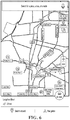
- FIG. 6 is a schematic diagram illustrating a conversion of a drag operation into distance information, according to the present application.
- FIG. 7 is a schematic diagram illustrating a display after a first location and a second location are selected, according to the present application.
- FIG. 8 is a schematic diagram illustrating a determined circular demarcated range, according to the present application.
- FIG. 9 is a schematic diagram illustrating a determined square demarcated range, according to the present application.
- FIG. 10 is a schematic diagram illustrating a determined sectorial demarcated range, according to the present application.
- FIG. 11 is a schematic diagram illustrating a search result, according to the present application.
- FIG. 12 is another flowchart illustrating a map display method, according to the present application.
- FIG. 13 is a schematic diagram illustrating distance information between a start point and an end point, according to the present application.
- FIG. 14 is a schematic diagram illustrating a map interaction method in a specific scenario, according to the present application.
- FIG. 15 is a schematic diagram illustrating hardware of a terminal, according to the present application.
- FIG. 16 is a schematic diagram illustrating a software module of a terminal, according to the present application.
- FIG. 17 is a schematic diagram illustrating another software module of a terminal, according to the present application.
- FIG. 18 is a schematic diagram illustrating hardware of a server, according to the present application.
- FIG. 19 is a schematic diagram illustrating a software module of a server, according to the present application.
- FIG. 20 is a flowchart illustrating an example of a computer-implemented method for map interface interaction, according to an implementation of the present disclosure.
- the present application provides a map interaction system.
- the system can include a user client 100 and a map server 200 , and the user client 100 is coupled to the map server 200 .
- the map interaction system can include one or more user clients 100 .
- the present application further provides a map interaction system, and the system can include a user client 100 .
- the user client 100 has locally stored map information, after the user client receives a search request, the user client does not need to request the map information from a map server, but directly extracts the information from the user client for a search and determining.
- the user client 100 can be a removable device.
- the user client 100 can be a mobile phone or a tablet computer.
- the user client 100 can be a desktop device such as a desktop personal computer (PC) or an all-in-one machine.
- PC desktop personal computer
- a user can obtain data information on a map distribution server 200 by using different user clients 100 in different scenarios, to plan a route.
- a current location can be used as an initial location, or a location can be entered as an initial location, or a location can be directly tapped on a map interface and used as an initial location. How to select the initial location can be determined based on an actual need, and is not limited in the present application.
- a map display method is provided. As shown in FIG. 2 , the method can include the following steps.
- Step 201 Obtain a map search operation.
- the map search operation can be a search operation generated by using information entered by a user in a search input box, or can be a search operation generated by using location information and distance information that are marked by a user on a map interface.
- the user can enter, on an interface shown in FIG. 3 , a target object and a distance range that the user wants to search, to obtain a presentation result shown in FIG. 4 .
- a bus station and 4 kilometers are entered.
- a corresponding map search operation is to search for a bus station within 4 kilometers of a current location.
- a final search result is a bus station within 4 kilometers.
- an initial location is the current location.
- a search input box can be set for entering an initial location. For example, if “Tianchao Company”, “Supermarket”, and “5 kilometers” are entered, a search operation is to search for a supermarket within 5 kilometers of Tianchao Company.
- the initial location, the target object, or the distance range can be entered in a plurality of methods.
- the methods are not limited to the several listed methods, for example:
- the initial location can be entered in a text form, can be selected by directly tapping a map, can be selected by the user from a provided list of frequent sites, etc.
- the target object can be entered in a text form, or can be selected from a specified target object list. For example, the user can make a tap operation in the target object list, and the target object can be displayed as “selected”.
- the distance range can be entered in a text form, can be marked through dragging on a map display interface by using a mouse or a touchscreen.
- Step 202 Determine a demarcated range and a target object based on the map search operation.
- the determining a demarcated range based on the map search operation can include: extracting a first location and a selected distance from the map search operation; and determining the demarcated range based on the first location and the selected distance.
- the first location can correspond to the initial location
- the selected distance can correspond to a distance selected or entered by the user.
- the extracting a first location and a selected distance from the map search operation can include the following steps:
- the user can directly mark a location on the map interface as the first location (namely, the initial location).
- the marking operation can be implemented by using a predetermined operation such as a tap operation or a double-tap operation.
- one distance determining point can be determined, to determine the selected distance. In other words, one straight line is determined by using two points, or one distance is determined by using two points.
- the distance determining point can be determined in one of the following methods:
- a drag operation whose start point is the first location on the map interface is identified, and an end point of the drag operation is used as the distance determining point.
- dragging can start from the first location, and a stop location is determined as the distance determining point; or after the first location is determined, one point is directly selected as the distance determining point.
- a drag operation can be converted into distance information in real time, to remind the user of a distance between a current location and the first location, so that the user determines whether dragging can be stopped.
- the current location is used as a drag stop location.
- a point selected by a user after the first location on the map interface is used as the distance determining point.
- “Longshan Mount” is selected as the first location
- “Huqiu District Government” can be further tapped and selected as a second location.
- the second location is used as the distance determining point.
- a linear distance between the second location and the first location can be displayed, so that the user can know an approximate distance between the two locations.
- the demarcated range can be determined by using methods that include but are not limited to the following methods:
- Method 1 As shown in FIG. 8 , a circle area is used as the demarcated range, and the circle area is generated by using the first location as a center and by using the distance between the first location and the distance determining point as a radius.
- Method 2 As shown in FIG. 9 , a square area is used as the demarcated range, and the square area is generated by using the first location as a center and by using the distance determining point as a vertex of a square.
- Method 3 As shown in FIG. 10 , a circular sector area with a predetermined angle is used as the demarcated range, and the circular sector area is generated by using the first location as a start point of the circular sector area, by using the distance between the first location and the distance determining point as a radius of the circular sector area, and by using a direction of the drag operation as a central direction of the circular sector area.
- the predetermined angle is 120°.
- another angle can be selected based on an actual need.
- a specific selected angle is not limited in the present application.
- Step 203 Show one or more target objects in the demarcated range as a search result set.
- the one or more target objects in the demarcated range can be shown as the search result set, and the demarcated range can be marked on the map interface.
- a plurality of search results can be obtained based on the first location, the demarcated range, and a target search object (fast food), and all the search results are fast food restaurants within 4 km of the first location, so that the search results are presented in the demarcated range. Therefore, when searching for an object in a predetermined range, the user can roughly determine a distance between each target search result and a start point, so that a distance parameter becomes more controllable, and the user can plan a search range more conveniently.
- the existing technology when a user searches a map for content such as a hotel or a scenic spot that has a strong location attribute, a relative distance is usually extremely concerned, but a distance parameter in a current interaction method for searching a map can hardly be controlled. According to the method provided in the previous example, the existing problem is alleviated, and the user can know a relative location better during a search, so that the user can more intuitively and conveniently make a search in a demarcated range.
- FIG. 12 is a flowchart of an implementation of another map display method according to the present application.
- the present application provides method operation steps or apparatus structures shown in the following implementations or accompanying drawings, conventionally or without creative efforts, the method can include more or fewer operation steps, or the apparatus can include more or fewer module units.
- an execution sequence of the steps or a module structure of the apparatus is not limited to an execution sequence or a module structure shown in the implementations or the accompanying drawings of the present application.
- the method or the module structure When the method or the module structure is applied to an actual apparatus or an actual terminal product, the method or the module structure can be executed based on the sequence of the method or the module structure in the implementations or the accompanying drawings, or can be executed in parallel (for example, a parallel processor, a multithreaded processing environment, or even a distributed processing environment).
- the another map display method provided in the present implementation of the present application can include the following steps.
- S 1203 Mark the first location and the second location on a map interface, and draw a line between the first location and the second location, where the distance between the first location and the second location is marked on the line.
- FIG. 13 is a schematic diagram illustrating an actual application scenario of the map display method.
- a user selects a start point (a first location) and an end point (a second location). Then a route search result is generated in a search state.
- a route is displayed as a line between the start point and the end point. A distance between the start point and the end point is directly displayed on the line, so that the user can more intuitively determine the distance between the two locations. Therefore, the user can immediately determine the route and the distance between the start point and the end point only from a graph display interface of the search result, improving user experience.
- Case 1 The user locally stores map information.
- a map package has been locally downloaded.
- a client After the user initiates a search request, a client does not need to initiate a search request to a map server, and only needs to obtain the map information from the client for identification and a search. As such, the client completes a search and interaction with the user.
- Case 2 The user does not locally store corresponding map information.
- a client of the user When a client of the user is connected to a network, the user initiates a search request by using the client, the client sends the search request to a map server, and the map server makes a search and match, and returns a search result to the client of the user for display.
- the client completes interaction with the user, and the map server completes a search and match.
- Case 3 The user does not locally store corresponding map information, and a client of the user is not connected to a network. In such a case, a map search function cannot be performed.
- a processing method and whether search and match operations are made by a terminal or a server can be determined based on an actual storage case, a networking status, etc. of the client of the user.
- a distance serving as a result filtering item is separated from a search action, so that repeated operations are made, and an operation method is not intuitive and easy for the user.
- a map interaction method including the following steps.
- S 1 A user taps and holds a location on a map to trigger range demarcation, and a prompt pops up.
- a presented interaction change can be shown in FIG. 14 .
- the user selects a point and taps and holds the point, to trigger a range demarcation operation.
- “Drag to select a search range” can be provided as a prompt below.
- the user demarcates the search range through dragging. During dragging, a dragged distance is converted into an actual distance on the map in real time. After the user stops dragging, a drag stop point is used as a boundary of a finally determined search range, and a search result in the search range is displayed.
- FIG. 15 is a schematic structural diagram illustrating a client, according to an example implementation of the present application.
- the client includes a processor, an internal bus, a network interface, a memory, and a nonvolatile memory, and certainly can further include hardware needed by other services.
- the processor reads a corresponding computer program from the nonvolatile memory to the memory for running, and a map interaction apparatus is logically formed.
- the present application does not exclude another implementation, for example, a logic device or a combination of hardware and software.
- an execution body of the following processing procedure is not limited to each logical unit, and can be hardware or a logic device.
- the map interaction apparatus is applied to a client terminal and can include an acquisition module, a determining module, and a showing module.
- the acquisition module is configured to obtain a map search operation.
- the determining module is configured to determine a demarcated range and a target object based on the map search operation.
- the showing module is configured to show one or more target objects in the demarcated range as a search result set.
- the map interaction apparatus is applied to a client terminal and can further include an acquisition module, a determining module, and a display module.
- the acquisition module is configured to obtain a map search operation.
- the sending module is configured to send the map search operation to a server, where the map search operation carries a demarcated range and a target object.
- the display module is configured to receive and display a search result returned by the server in response to the map search operation, where the search result includes one or more target objects in the demarcated range.
- the map interaction apparatus is applied to a client terminal and can further include an acquisition module, a determining module, and a display module.
- the acquisition module is configured to obtain a map search operation, where the map search operation carries a first location and a second location.
- the determining module is configured to determine a distance between the first location and the second location in response to the map search operation.
- the display module is configured to mark the first location and the second location on a map interface and draw a line between the first location and the second location, where the distance between the first location and the second location is marked on the line.
- FIG. 18 is a schematic structural diagram illustrating a server, according to an example implementation of the present application.
- the server includes a processor, an internal bus, a network interface, a memory, and a nonvolatile memory, and certainly can further include hardware needed by other services.
- the processor reads a corresponding computer program from the nonvolatile memory to the memory for running, and a map interaction apparatus is logically formed.
- the present application does not exclude another implementation, for example, a logic device or a combination of hardware and software.
- an execution body of the following processing procedure is not limited to each logical unit, and can be hardware or a logic device.
- the map interaction apparatus is applied to the server and can include a receiving module, a determining module, and a push module.
- the receiving module is configured to receive a map search operation.
- the determining module is configured to determine a demarcated range and a target object based on the map search operation.
- the push module is configured to push one or more target objects in the demarcated range to a terminal side as a search result.
- the apparatus, the system, the server, and the terminal for map interaction, search, and display provided in the present application, interaction, search, and display are based on the demarcated range.
- the search result is presented, only a result in the demarcated range is displayed. Therefore, a system resource is saved. Further, when the search result is displayed, the demarcated range of the user is also displayed, so that the user can clearly know a relative distance of each search result, etc. through one search, to effectively improve user experience.
- the apparatuses or modules described in the previous implementations can be implemented by a computer chip or an entity, or can be implemented by a product with a certain function.
- the previous apparatus is described by dividing the functions into various modules.
- the functions of all modules can be implemented in one or more pieces of software and/or hardware.
- a module that implements a certain function can be implemented by using a combination of a plurality of submodules or subunits.
- a controller can be implemented in any appropriate way.
- the controller can take the form of, for example, a microprocessor, a processor, a computer readable medium storing computer readable program code (for example, software or firmware) that can be executed by the microprocessor or the processor, a logic gate, a switch, an application-specific integrated circuit (ASIC), a programmable logic controller, or an embedded microcontroller.
- the controller include but are not limited to the following microcontrollers: ARC 625D, Atmel AT91SAM, Microchip PIC18F26K20, and Silicone Labs C8051F320.
- a memory controller can be implemented as a part of control logic of a memory.
- a person skilled in the art also knows that, in addition to implementing the controller by using the computer readable program code, method steps can be logically programmed to allow the controller to implement the same function in forms of the logic gate, the switch, the application-specific integrated circuit, the programmable logic controller, and the embedded microcontroller. Therefore, the controller can be considered as a hardware component, and an apparatus included in the controller and configured to implement various functions can also be considered as a structure in the hardware component. Or the apparatus configured to implement various functions can even be considered as both a software module implementing the method and a structure in the hardware component.
- modules of the apparatus in the present application can be described in the general context of a computer executable instruction executed by a computer, for example, a program module.
- the program module includes a routine, a program, an object, a component, a data structure, a type, etc. that executes a specific task or implements a specific abstract data type.
- the present application can also be practiced in distributed computing environments. In the distributed computing environments, tasks are performed by remote processing devices connected through a communications network. In the distributed computing environment, the program module can be located in both local and remote computer storage media including storage devices.
- the present application can be implemented by using software and necessary hardware. Based on such an understanding, the technical solutions of the present application essentially, or the part contributing to the existing technologies can be implemented in the form of a software product or can be implemented during a data migration implementation process.
- the computer software product can be stored in a storage medium, such as a ROM/RAM, a magnetic disk, or an optical disc, and includes several instructions for instructing a computer device (which can be a personal computer, a mobile device, a server, a network device, etc.) to perform the methods described in the implementations of the present application or some parts of the implementations.
- FIG. 20 is a flowchart illustrating an example of a computer-implemented method 2000 for map interface interaction, according to an implementation of the present disclosure.
- method 2000 can be performed, for example, by any system, environment, software, and hardware, or a combination of systems, environments, software, and hardware, as appropriate.
- steps of method 2000 can be run in parallel, in combination, in loops, or in any order.
- receiving the user input specifying the map search operation includes identifying a drag operation whose start point is the first location on the map interface, and using an end point of the drag operation as the distance determining point.
- receiving the user input specifying the map search operation includes identifying a point selected by a user after the first location on the map interface as the distance determining point.
- receiving the user input specifying the map search operation includes receiving text entered by a user in a text form, the text representing the first location and the selected distance.
- a selected distance between the first location and the distance determining point is determined, wherein the selected distance represents a physical distance between the physical locations represented by the first location and the distance determining point.
- a demarcated range is determined based on the first location and the selected distance, the demarcated range representing a subset of the physical area.
- determining the demarcated range based on the first location and the selected distance includes generating a circle area as the demarcated range, the circle area having the first location as a center and the distance between the first location and the distance determining point as a radius.
- determining the demarcated range based on the first location and the selected distance includes generating a square area as the demarcated range, the square area having the first location as a center and the distance determining point as a vertex of the square area.
- determining the demarcated range based on the first location and the selected distance includes generating circular sector area with a predetermined angle as the demarcated range, the circular sector area having the first location as a start point, the distance between the first location and the distance determining point as a radius, and a drag operation received as user input as a central direction.
- one or more target objects in the demarcated range are displayed as a search result set, each target object associated with a physical location in the subset of the physical area represented by the demarcated range.
- receiving the user input specifying the map search operation includes receiving touch input representing the first location and the selected distance from a visual map interface displayed on a touchscreen display, and wherein displaying the one or more target objects in the demarcated range as a search result set includes displaying the demarcated range on the visual map interface.
- the method 2000 include prior to displaying the one or more target objects: sending a search request to a map server, the search request including the demarcated range; and receiving a search response from the server including the one or more target objects in the demarcated range.
- the present techniques relate to user interaction with a visual map interface, such as a visual map interface displayed on a touchscreen display of a user device.
- the techniques enable a user to search for target objects (e.g., types of businesses, landmarks, etc.) within a specified distance of a particular location.
- a user can input the specified distance and the particular location into the visual map interface (e.g., by touching points on the screen or entering text).
- a demarcated range is then generated from the specified distance and the particular location.
- the demarcated range is a geometric shape (e.g., a circle, square, etc.) representing a portion of the physical area represented by the displayed map.
- Target objects meeting search criteria provided by the user that are within the demarcated range are displayed as search results (e.g., displayed as points in the visual map interface).
- Embodiments and the operations described in this specification can be implemented in digital electronic circuitry, or in computer software, firmware, or hardware, including the structures disclosed in this specification or in combinations of one or more of them.
- the operations can be implemented as operations performed by a data processing apparatus on data stored on one or more computer-readable storage devices or received from other sources.
- a data processing apparatus, computer, or computing device may encompass apparatus, devices, and machines for processing data, including by way of example a programmable processor, a computer, a system on a chip, or multiple ones, or combinations, of the foregoing.
- the apparatus can include special purpose logic circuitry, for example, a central processing unit (CPU), a field programmable gate array (FPGA) or an application-specific integrated circuit (ASIC).
- CPU central processing unit
- FPGA field programmable gate array
- ASIC application-specific integrated circuit
- the apparatus can also include code that creates an execution environment for the computer program in question, for example, code that constitutes processor firmware, a protocol stack, a database management system, an operating system (for example an operating system or a combination of operating systems), a cross-platform runtime environment, a virtual machine, or a combination of one or more of them.
- the apparatus and execution environment can realize various different computing model infrastructures, such as web services, distributed computing and grid computing infrastructures.
- a computer program (also known, for example, as a program, software, software application, software module, software unit, script, or code) can be written in any form of programming language, including compiled or interpreted languages, declarative or procedural languages, and it can be deployed in any form, including as a stand-alone program or as a module, component, subroutine, object, or other unit suitable for use in a computing environment.
- a program can be stored in a portion of a file that holds other programs or data (for example, one or more scripts stored in a markup language document), in a single file dedicated to the program in question, or in multiple coordinated files (for example, files that store one or more modules, sub-programs, or portions of code).
- a computer program can be executed on one computer or on multiple computers that are located at one site or distributed across multiple sites and interconnected by a communication network.
- processors for execution of a computer program include, by way of example, both general- and special-purpose microprocessors, and any one or more processors of any kind of digital computer.
- a processor will receive instructions and data from a read-only memory or a random-access memory or both.
- the essential elements of a computer are a processor for performing actions in accordance with instructions and one or more memory devices for storing instructions and data.
- a computer will also include, or be operatively coupled to receive data from or transfer data to, or both, one or more mass storage devices for storing data.
- a computer can be embedded in another device, for example, a mobile device, a personal digital assistant (PDA), a game console, a Global Positioning System (GPS) receiver, or a portable storage device.
- PDA personal digital assistant
- GPS Global Positioning System
- Devices suitable for storing computer program instructions and data include non-volatile memory, media and memory devices, including, by way of example, semiconductor memory devices, magnetic disks, and magneto-optical disks.
- the processor and the memory can be supplemented by, or incorporated in, special-purpose logic circuitry.
- Mobile devices can include handsets, user equipment (UE), mobile telephones (for example, smartphones), tablets, wearable devices (for example, smart watches and smart eyeglasses), implanted devices within the human body (for example, biosensors, cochlear implants), or other types of mobile devices.
- the mobile devices can communicate wirelessly (for example, using radio frequency (RF) signals) to various communication networks (described below).
- RF radio frequency
- the mobile devices can include sensors for determining characteristics of the mobile device's current environment.
- the sensors can include cameras, microphones, proximity sensors, GPS sensors, motion sensors, accelerometers, ambient light sensors, moisture sensors, gyroscopes, compasses, barometers, fingerprint sensors, facial recognition systems, RF sensors (for example, Wi-Fi and cellular radios), thermal sensors, or other types of sensors.
- the cameras can include a forward- or rear-facing camera with movable or fixed lenses, a flash, an image sensor, and an image processor.
- the camera can be a megapixel camera capable of capturing details for facial and/or iris recognition.
- the camera along with a data processor and authentication information stored in memory or accessed remotely can form a facial recognition system.
- the facial recognition system or one-or-more sensors for example, microphones, motion sensors, accelerometers, GPS sensors, or RF sensors, can be used for user authentication.
- embodiments can be implemented on a computer having a display device and an input device, for example, a liquid crystal display (LCD) or organic light-emitting diode (OLED)/virtual-reality (VR)/augmented-reality (AR) display for displaying information to the user and a touchscreen, keyboard, and a pointing device by which the user can provide input to the computer.
- LCD liquid crystal display
- OLED organic light-emitting diode
- VR virtual-reality
- AR pointing device
- Other kinds of devices can be used to provide for interaction with a user as well; for example, feedback provided to the user can be any form of sensory feedback, for example, visual feedback, auditory feedback, or tactile feedback; and input from the user can be received in any form, including acoustic, speech, or tactile input.
- a computer can interact with a user by sending documents to and receiving documents from a device that is used by the user; for example, by sending web pages to a web browser on a user's client device in response
- Embodiments can be implemented using computing devices interconnected by any form or medium of wireline or wireless digital data communication (or combination thereof), for example, a communication network.
- interconnected devices are a client and a server generally remote from each other that typically interact through a communication network.
- a client for example, a mobile device, can carry out transactions itself, with a server, or through a server, for example, performing buy, sell, pay, give, send, or loan transactions, or authorizing the same.
- Such transactions may be in real time such that an action and a response are temporally proximate; for example an individual perceives the action and the response occurring substantially simultaneously, the time difference for a response following the individual's action is less than 1 millisecond (ms) or less than 1 second (s), or the response is without intentional delay taking into account processing limitations of the system.
- ms millisecond
- s 1 second
- Examples of communication networks include a local area network (LAN), a radio access network (RAN), a metropolitan area network (MAN), and a wide area network (WAN).
- the communication network can include all or a portion of the Internet, another communication network, or a combination of communication networks.
- Information can be transmitted on the communication network according to various protocols and standards, including Long Term Evolution (LTE), 5G, IEEE 802, Internet Protocol (IP), or other protocols or combinations of protocols.
- LTE Long Term Evolution
- 5G Fifth Generation
- IEEE 802 Internet Protocol
- IP Internet Protocol
- the communication network can transmit voice, video, biometric, or authentication data, or other information between the connected computing devices.
Landscapes
- Engineering & Computer Science (AREA)
- Theoretical Computer Science (AREA)
- Databases & Information Systems (AREA)
- General Engineering & Computer Science (AREA)
- General Physics & Mathematics (AREA)
- Physics & Mathematics (AREA)
- Data Mining & Analysis (AREA)
- Remote Sensing (AREA)
- Human Computer Interaction (AREA)
- Computational Linguistics (AREA)
- User Interface Of Digital Computer (AREA)
- Navigation (AREA)
- Instructional Devices (AREA)
Priority Applications (2)
| Application Number | Priority Date | Filing Date | Title |
|---|---|---|---|
| US16/914,065 US10963152B2 (en) | 2016-11-07 | 2020-06-26 | Map interface interaction |
| US17/213,729 US11099730B2 (en) | 2016-11-07 | 2021-03-26 | Map interface interaction |
Applications Claiming Priority (4)
| Application Number | Priority Date | Filing Date | Title |
|---|---|---|---|
| CN201610976063 | 2016-11-07 | ||
| CN201610976063.X | 2016-11-07 | ||
| CN201610976063.XA CN106933940A (zh) | 2016-11-07 | 2016-11-07 | 地图交互、搜索、显示方法、装置和系统、服务器、终端 |
| PCT/CN2017/107481 WO2018082475A1 (zh) | 2016-11-07 | 2017-10-24 | 地图交互、搜索、显示方法、装置和系统、服务器、终端 |
Related Parent Applications (1)
| Application Number | Title | Priority Date | Filing Date |
|---|---|---|---|
| PCT/CN2017/107481 Continuation WO2018082475A1 (zh) | 2016-11-07 | 2017-10-24 | 地图交互、搜索、显示方法、装置和系统、服务器、终端 |
Related Child Applications (1)
| Application Number | Title | Priority Date | Filing Date |
|---|---|---|---|
| US16/914,065 Continuation US10963152B2 (en) | 2016-11-07 | 2020-06-26 | Map interface interaction |
Publications (2)
| Publication Number | Publication Date |
|---|---|
| US20190258374A1 US20190258374A1 (en) | 2019-08-22 |
| US10732816B2 true US10732816B2 (en) | 2020-08-04 |
Family
ID=59444463
Family Applications (3)
| Application Number | Title | Priority Date | Filing Date |
|---|---|---|---|
| US16/405,343 Active US10732816B2 (en) | 2016-11-07 | 2019-05-07 | Map interface interaction |
| US16/914,065 Active US10963152B2 (en) | 2016-11-07 | 2020-06-26 | Map interface interaction |
| US17/213,729 Active US11099730B2 (en) | 2016-11-07 | 2021-03-26 | Map interface interaction |
Family Applications After (2)
| Application Number | Title | Priority Date | Filing Date |
|---|---|---|---|
| US16/914,065 Active US10963152B2 (en) | 2016-11-07 | 2020-06-26 | Map interface interaction |
| US17/213,729 Active US11099730B2 (en) | 2016-11-07 | 2021-03-26 | Map interface interaction |
Country Status (8)
| Country | Link |
|---|---|
| US (3) | US10732816B2 (enExample) |
| EP (1) | EP3537309A4 (enExample) |
| JP (1) | JP7106559B2 (enExample) |
| KR (1) | KR102268942B1 (enExample) |
| CN (1) | CN106933940A (enExample) |
| SG (1) | SG10202101144XA (enExample) |
| TW (1) | TWI676905B (enExample) |
| WO (1) | WO2018082475A1 (enExample) |
Cited By (2)
| Publication number | Priority date | Publication date | Assignee | Title |
|---|---|---|---|---|
| USD911377S1 (en) * | 2017-03-07 | 2021-02-23 | CommuniCare Technology, Inc. | Display screen or portion thereof with a graphical user interface of an electronic device |
| US10963152B2 (en) | 2016-11-07 | 2021-03-30 | Advanced New Technologies Co., Ltd. | Map interface interaction |
Families Citing this family (18)
| Publication number | Priority date | Publication date | Assignee | Title |
|---|---|---|---|---|
| CN107491489A (zh) * | 2017-07-18 | 2017-12-19 | 深圳天珑无线科技有限公司 | 一种地图搜索方法、装置及计算机可读存储介质 |
| CN107506376B (zh) * | 2017-07-18 | 2021-02-09 | 口碑控股有限公司 | 获取区域内信息点数据的客户端 |
| CN116204733A (zh) * | 2017-09-22 | 2023-06-02 | 阿里巴巴集团控股有限公司 | 多目的地的查看方法和装置、用于查看的设备和存储介质 |
| CN109300006B (zh) * | 2018-09-21 | 2021-09-03 | 北京京东尚科信息技术有限公司 | 住宿场所推荐方法和系统、计算机可读存储介质 |
| CN112985373B (zh) * | 2019-12-18 | 2023-08-01 | 中国移动通信集团四川有限公司 | 路径规划方法、装置及电子设备 |
| CN111125287A (zh) * | 2019-12-25 | 2020-05-08 | 深圳集智数字科技有限公司 | 一种确定目标地图范围的方法和相关装置 |
| CN111414447A (zh) * | 2020-03-26 | 2020-07-14 | 北京明略软件系统有限公司 | 一种地图圈选方法和装置 |
| CN111931044A (zh) * | 2020-07-23 | 2020-11-13 | 北京字节跳动网络技术有限公司 | 信息展示方法、装置和电子设备 |
| TWI819289B (zh) * | 2021-03-30 | 2023-10-21 | 財團法人工業技術研究院 | 分散式協作運算方法及系統 |
| CN113198178B (zh) * | 2021-06-03 | 2023-05-26 | 腾讯科技(深圳)有限公司 | 虚拟对象的位置提示方法、装置、终端及存储介质 |
| CN116340649A (zh) * | 2021-12-24 | 2023-06-27 | 上海博泰悦臻网络技术服务有限公司 | 复合目的地的地图搜索方法、装置、存储介质及电子设备 |
| CN114553526A (zh) * | 2022-02-22 | 2022-05-27 | 国网河北省电力有限公司电力科学研究院 | 网络安全漏洞位置检测方法及系统 |
| CN114880557B (zh) * | 2022-04-25 | 2025-09-19 | 厦门云评众联科技有限公司 | 目标资源的搜索方法和搜索装置、电子设备 |
| CN114637798A (zh) * | 2022-05-07 | 2022-06-17 | 北京金堤科技有限公司 | 商业信息的地图查询方法和装置 |
| CN115064169B (zh) * | 2022-08-17 | 2022-12-13 | 广州小鹏汽车科技有限公司 | 语音交互方法、服务器和存储介质 |
| CN115494990A (zh) * | 2022-09-09 | 2022-12-20 | 贝壳找房(北京)科技有限公司 | 辅助交互的方法和装置 |
| CN116415080A (zh) * | 2023-03-29 | 2023-07-11 | 一汽奔腾轿车有限公司 | 一种确定地点搜索范围方法 |
| CN119743636A (zh) * | 2024-12-06 | 2025-04-01 | 北京字跳网络技术有限公司 | 界面交互的方法、装置、设备和存储介质 |
Citations (22)
| Publication number | Priority date | Publication date | Assignee | Title |
|---|---|---|---|---|
| US20080104027A1 (en) | 2006-11-01 | 2008-05-01 | Sean Michael Imler | System and method for dynamically retrieving data specific to a region of a layer |
| US20090210416A1 (en) | 2007-08-29 | 2009-08-20 | Bennett James D | Search engine using world map with whois database search restrictions |
| CN101996256A (zh) | 2010-11-25 | 2011-03-30 | 杨军辉 | 搜索方法、移动信息终端集成子系统及搜索系统 |
| US20110093458A1 (en) * | 2009-09-25 | 2011-04-21 | Microsoft Corporation | Recommending points of interests in a region |
| US20110167058A1 (en) * | 2010-01-06 | 2011-07-07 | Van Os Marcel | Device, Method, and Graphical User Interface for Mapping Directions Between Search Results |
| US20110193795A1 (en) | 2010-02-09 | 2011-08-11 | Yahoo! Inc. | Haptic search feature for touch screens |
| US20120068943A1 (en) | 2010-09-16 | 2012-03-22 | Mstar Semiconductor, Inc. | Method and Electronic Device for Retrieving Geographic Information |
| CN102473179A (zh) | 2009-07-17 | 2012-05-23 | 瑞典爱立信有限公司 | 数字地图的显现 |
| CN102708214A (zh) | 2012-06-15 | 2012-10-03 | 深圳市凯立德科技股份有限公司 | 一种搜索兴趣点的方法及终端 |
| CN102915348A (zh) | 2012-09-27 | 2013-02-06 | 北京百度网讯科技有限公司 | 在地图中向用户推荐搜索信息的方法及系统 |
| CN103092965A (zh) | 2013-01-22 | 2013-05-08 | 百度在线网络技术(北京)有限公司 | 基于移动终端中地图进行搜索的方法、系统、终端和服务器 |
| US20130173577A1 (en) | 2009-12-04 | 2013-07-04 | Tak Keung Cheng | Location-Based Searching Using a Search Area That Corresponds to a Geographical Location of a Computing Device |
| US20130176321A1 (en) | 2012-01-06 | 2013-07-11 | Google Inc. | System and method for displaying information local to a selected area |
| CN103425655A (zh) | 2012-05-16 | 2013-12-04 | 腾讯科技(深圳)有限公司 | 基于位置服务的场馆信息搜索方法和装置 |
| CN103955534A (zh) | 2014-05-13 | 2014-07-30 | 百度在线网络技术(北京)有限公司 | 地图查询方法及装置 |
| CN104731783A (zh) | 2013-12-18 | 2015-06-24 | 高德软件有限公司 | 一种展示兴趣点的方法和装置 |
| CN104915393A (zh) | 2015-05-26 | 2015-09-16 | 百度在线网络技术(北京)有限公司 | 一种用于方向定向搜索的方法与设备 |
| CN105302886A (zh) | 2015-10-15 | 2016-02-03 | 百度在线网络技术(北京)有限公司 | 实体对象的处理方法及装置 |
| US20160097654A1 (en) * | 2011-02-02 | 2016-04-07 | Mapquest, Inc. | Systems and methods for generating electronic map displays with points-of-interest information based on reference locations |
| TWM530444U (zh) | 2016-05-27 | 2016-10-11 | Sinyi Realty Inc | 距離可選的生活機能顯示處理裝置 |
| CN106933940A (zh) | 2016-11-07 | 2017-07-07 | 阿里巴巴集团控股有限公司 | 地图交互、搜索、显示方法、装置和系统、服务器、终端 |
| US20190271555A1 (en) * | 2014-06-27 | 2019-09-05 | Google Llc | Generating Turn-By-Turn Direction Previews |
Family Cites Families (5)
| Publication number | Priority date | Publication date | Assignee | Title |
|---|---|---|---|---|
| JP3879659B2 (ja) | 2002-11-27 | 2007-02-14 | ブラザー工業株式会社 | 文書読み上げ装置、同装置用プログラム及び記録媒体 |
| JP2009015388A (ja) * | 2007-06-29 | 2009-01-22 | Casio Comput Co Ltd | 電子式計算機および制御プログラム |
| US9141640B2 (en) * | 2008-07-09 | 2015-09-22 | MLSListings, Inc. | Methods and systems of advanced real estate searching |
| JP2011192123A (ja) * | 2010-03-16 | 2011-09-29 | Yanmar Co Ltd | 薬剤散布管理システム |
| JP2014164316A (ja) | 2013-02-21 | 2014-09-08 | Honda Motor Co Ltd | 車載カメラを用いた情報提供システム |
-
2016
- 2016-11-07 CN CN201610976063.XA patent/CN106933940A/zh active Pending
-
2017
- 2017-09-13 TW TW106131348A patent/TWI676905B/zh not_active IP Right Cessation
- 2017-10-24 KR KR1020197016089A patent/KR102268942B1/ko active Active
- 2017-10-24 WO PCT/CN2017/107481 patent/WO2018082475A1/zh not_active Ceased
- 2017-10-24 JP JP2019544962A patent/JP7106559B2/ja active Active
- 2017-10-24 SG SG10202101144XA patent/SG10202101144XA/en unknown
- 2017-10-24 EP EP17868085.6A patent/EP3537309A4/en not_active Withdrawn
-
2019
- 2019-05-07 US US16/405,343 patent/US10732816B2/en active Active
-
2020
- 2020-06-26 US US16/914,065 patent/US10963152B2/en active Active
-
2021
- 2021-03-26 US US17/213,729 patent/US11099730B2/en active Active
Patent Citations (22)
| Publication number | Priority date | Publication date | Assignee | Title |
|---|---|---|---|---|
| US20080104027A1 (en) | 2006-11-01 | 2008-05-01 | Sean Michael Imler | System and method for dynamically retrieving data specific to a region of a layer |
| US20090210416A1 (en) | 2007-08-29 | 2009-08-20 | Bennett James D | Search engine using world map with whois database search restrictions |
| CN102473179A (zh) | 2009-07-17 | 2012-05-23 | 瑞典爱立信有限公司 | 数字地图的显现 |
| US20110093458A1 (en) * | 2009-09-25 | 2011-04-21 | Microsoft Corporation | Recommending points of interests in a region |
| US20130173577A1 (en) | 2009-12-04 | 2013-07-04 | Tak Keung Cheng | Location-Based Searching Using a Search Area That Corresponds to a Geographical Location of a Computing Device |
| US20110167058A1 (en) * | 2010-01-06 | 2011-07-07 | Van Os Marcel | Device, Method, and Graphical User Interface for Mapping Directions Between Search Results |
| US20110193795A1 (en) | 2010-02-09 | 2011-08-11 | Yahoo! Inc. | Haptic search feature for touch screens |
| US20120068943A1 (en) | 2010-09-16 | 2012-03-22 | Mstar Semiconductor, Inc. | Method and Electronic Device for Retrieving Geographic Information |
| CN101996256A (zh) | 2010-11-25 | 2011-03-30 | 杨军辉 | 搜索方法、移动信息终端集成子系统及搜索系统 |
| US20160097654A1 (en) * | 2011-02-02 | 2016-04-07 | Mapquest, Inc. | Systems and methods for generating electronic map displays with points-of-interest information based on reference locations |
| US20130176321A1 (en) | 2012-01-06 | 2013-07-11 | Google Inc. | System and method for displaying information local to a selected area |
| CN103425655A (zh) | 2012-05-16 | 2013-12-04 | 腾讯科技(深圳)有限公司 | 基于位置服务的场馆信息搜索方法和装置 |
| CN102708214A (zh) | 2012-06-15 | 2012-10-03 | 深圳市凯立德科技股份有限公司 | 一种搜索兴趣点的方法及终端 |
| CN102915348A (zh) | 2012-09-27 | 2013-02-06 | 北京百度网讯科技有限公司 | 在地图中向用户推荐搜索信息的方法及系统 |
| CN103092965A (zh) | 2013-01-22 | 2013-05-08 | 百度在线网络技术(北京)有限公司 | 基于移动终端中地图进行搜索的方法、系统、终端和服务器 |
| CN104731783A (zh) | 2013-12-18 | 2015-06-24 | 高德软件有限公司 | 一种展示兴趣点的方法和装置 |
| CN103955534A (zh) | 2014-05-13 | 2014-07-30 | 百度在线网络技术(北京)有限公司 | 地图查询方法及装置 |
| US20190271555A1 (en) * | 2014-06-27 | 2019-09-05 | Google Llc | Generating Turn-By-Turn Direction Previews |
| CN104915393A (zh) | 2015-05-26 | 2015-09-16 | 百度在线网络技术(北京)有限公司 | 一种用于方向定向搜索的方法与设备 |
| CN105302886A (zh) | 2015-10-15 | 2016-02-03 | 百度在线网络技术(北京)有限公司 | 实体对象的处理方法及装置 |
| TWM530444U (zh) | 2016-05-27 | 2016-10-11 | Sinyi Realty Inc | 距離可選的生活機能顯示處理裝置 |
| CN106933940A (zh) | 2016-11-07 | 2017-07-07 | 阿里巴巴集团控股有限公司 | 地图交互、搜索、显示方法、装置和系统、服务器、终端 |
Non-Patent Citations (4)
| Title |
|---|
| Crosby et al., "BlockChain Technology: Beyond Bitcoin," Sutardja Center for Entrepreneurship & Technology Technical Report, Oct. 16, 2015, 35 pages. |
| Extended European Search Report issued in European Application No. 17868085.6 dated Jul. 18, 2019, 11 pages. |
| Nakamoto, "Bitcoin: A Peer-to-Peer Electronic Cash System," www.bitcoin.org, 2005, 9 pages. |
| PCT International Search Report issued in International Application No. PCT/CN2017/107481 dated Feb. 1, 2018, 16 pages (with English translation). |
Cited By (3)
| Publication number | Priority date | Publication date | Assignee | Title |
|---|---|---|---|---|
| US10963152B2 (en) | 2016-11-07 | 2021-03-30 | Advanced New Technologies Co., Ltd. | Map interface interaction |
| US11099730B2 (en) | 2016-11-07 | 2021-08-24 | Advanced New Technologies Co., Ltd. | Map interface interaction |
| USD911377S1 (en) * | 2017-03-07 | 2021-02-23 | CommuniCare Technology, Inc. | Display screen or portion thereof with a graphical user interface of an electronic device |
Also Published As
| Publication number | Publication date |
|---|---|
| KR102268942B1 (ko) | 2021-06-28 |
| TW201818276A (zh) | 2018-05-16 |
| EP3537309A1 (en) | 2019-09-11 |
| KR20190072646A (ko) | 2019-06-25 |
| US10963152B2 (en) | 2021-03-30 |
| CN106933940A (zh) | 2017-07-07 |
| JP2019537178A (ja) | 2019-12-19 |
| EP3537309A4 (en) | 2019-09-11 |
| US20210216181A1 (en) | 2021-07-15 |
| JP7106559B2 (ja) | 2022-07-26 |
| US11099730B2 (en) | 2021-08-24 |
| TWI676905B (zh) | 2019-11-11 |
| US20190258374A1 (en) | 2019-08-22 |
| SG10202101144XA (en) | 2021-03-30 |
| WO2018082475A1 (zh) | 2018-05-11 |
| US20200326825A1 (en) | 2020-10-15 |
Similar Documents
| Publication | Publication Date | Title |
|---|---|---|
| US11099730B2 (en) | Map interface interaction | |
| US11157585B2 (en) | Information display method and device | |
| US10691794B2 (en) | Method, apparatus, and electronic device for detecting model security | |
| US10827010B2 (en) | Information presentation method and apparatus | |
| US20190279425A1 (en) | Augmented-reality-based offline interaction method and apparatus | |
| US10643615B2 (en) | Voice function control method and apparatus | |
| US10664289B2 (en) | Loading sub-applications for a terminal application | |
| US10831740B2 (en) | Parallel processing of service data corresponding to multiple target objects | |
| EP3745642B1 (en) | Blockchain data processing method and apparatus | |
| US11100442B2 (en) | Method and device for implementing service function | |
| US10989559B2 (en) | Methods, systems, and devices for displaying maps | |
| US20200201719A1 (en) | Blockchain-based consensus method and device | |
| US10831344B2 (en) | Page positioning method and apparatus for erroneous input information | |
| US10782867B2 (en) | Controlling method and device for slider control, and slider selector | |
| WO2019014592A1 (en) | METHOD AND DEVICE FOR PROCESSING DATA BASED ON BLOCK CHAIN | |
| US10904707B2 (en) | Location-based service implementing method and apparatus | |
| US11064112B2 (en) | Image display method and device, and electronic device | |
| US10846355B2 (en) | Method and device for page display | |
| US20190287081A1 (en) | Method and device for implementing service operations based on images | |
| CN108151748A (zh) | 飞行装置测绘作业航线规划方法、装置和终端 |
Legal Events
| Date | Code | Title | Description |
|---|---|---|---|
| FEPP | Fee payment procedure |
Free format text: ENTITY STATUS SET TO UNDISCOUNTED (ORIGINAL EVENT CODE: BIG.); ENTITY STATUS OF PATENT OWNER: LARGE ENTITY |
|
| STPP | Information on status: patent application and granting procedure in general |
Free format text: SPECIAL NEW |
|
| STPP | Information on status: patent application and granting procedure in general |
Free format text: NON FINAL ACTION MAILED |
|
| STPP | Information on status: patent application and granting procedure in general |
Free format text: RESPONSE TO NON-FINAL OFFICE ACTION ENTERED AND FORWARDED TO EXAMINER |
|
| AS | Assignment |
Owner name: ALIBABA GROUP HOLDING LIMITED, CAYMAN ISLANDS Free format text: ASSIGNMENT OF ASSIGNORS INTEREST;ASSIGNOR:ZHANG, SHUHONG;REEL/FRAME:051408/0936 Effective date: 20191231 |
|
| STPP | Information on status: patent application and granting procedure in general |
Free format text: NOTICE OF ALLOWANCE MAILED -- APPLICATION RECEIVED IN OFFICE OF PUBLICATIONS |
|
| STPP | Information on status: patent application and granting procedure in general |
Free format text: DOCKETED NEW CASE - READY FOR EXAMINATION |
|
| STPP | Information on status: patent application and granting procedure in general |
Free format text: NON FINAL ACTION MAILED |
|
| STPP | Information on status: patent application and granting procedure in general |
Free format text: NOTICE OF ALLOWANCE MAILED -- APPLICATION RECEIVED IN OFFICE OF PUBLICATIONS |
|
| STPP | Information on status: patent application and granting procedure in general |
Free format text: PUBLICATIONS -- ISSUE FEE PAYMENT VERIFIED |
|
| STCF | Information on status: patent grant |
Free format text: PATENTED CASE |
|
| AS | Assignment |
Owner name: ADVANTAGEOUS NEW TECHNOLOGIES CO., LTD., CAYMAN ISLANDS Free format text: ASSIGNMENT OF ASSIGNORS INTEREST;ASSIGNOR:ALIBABA GROUP HOLDING LIMITED;REEL/FRAME:053743/0464 Effective date: 20200826 |
|
| AS | Assignment |
Owner name: ADVANCED NEW TECHNOLOGIES CO., LTD., CAYMAN ISLANDS Free format text: ASSIGNMENT OF ASSIGNORS INTEREST;ASSIGNOR:ADVANTAGEOUS NEW TECHNOLOGIES CO., LTD.;REEL/FRAME:053754/0625 Effective date: 20200910 |
|
| MAFP | Maintenance fee payment |
Free format text: PAYMENT OF MAINTENANCE FEE, 4TH YEAR, LARGE ENTITY (ORIGINAL EVENT CODE: M1551); ENTITY STATUS OF PATENT OWNER: LARGE ENTITY Year of fee payment: 4 |