RU2413959C2 - Method for position finding by cross linking measurements - Google Patents
Method for position finding by cross linking measurements Download PDFInfo
- Publication number
- RU2413959C2 RU2413959C2 RU2008139422/09A RU2008139422A RU2413959C2 RU 2413959 C2 RU2413959 C2 RU 2413959C2 RU 2008139422/09 A RU2008139422/09 A RU 2008139422/09A RU 2008139422 A RU2008139422 A RU 2008139422A RU 2413959 C2 RU2413959 C2 RU 2413959C2
- Authority
- RU
- Russia
- Prior art keywords
- measurement
- pseudorange
- subset
- reference stations
- filter
- Prior art date
Links
Images


Classifications
-
- G—PHYSICS
- G01—MEASURING; TESTING
- G01S—RADIO DIRECTION-FINDING; RADIO NAVIGATION; DETERMINING DISTANCE OR VELOCITY BY USE OF RADIO WAVES; LOCATING OR PRESENCE-DETECTING BY USE OF THE REFLECTION OR RERADIATION OF RADIO WAVES; ANALOGOUS ARRANGEMENTS USING OTHER WAVES
- G01S19/00—Satellite radio beacon positioning systems; Determining position, velocity or attitude using signals transmitted by such systems
- G01S19/01—Satellite radio beacon positioning systems transmitting time-stamped messages, e.g. GPS [Global Positioning System], GLONASS [Global Orbiting Navigation Satellite System] or GALILEO
- G01S19/03—Cooperating elements; Interaction or communication between different cooperating elements or between cooperating elements and receivers
- G01S19/05—Cooperating elements; Interaction or communication between different cooperating elements or between cooperating elements and receivers providing aiding data
- G01S19/06—Cooperating elements; Interaction or communication between different cooperating elements or between cooperating elements and receivers providing aiding data employing an initial estimate of the location of the receiver as aiding data or in generating aiding data
-
- G—PHYSICS
- G01—MEASURING; TESTING
- G01S—RADIO DIRECTION-FINDING; RADIO NAVIGATION; DETERMINING DISTANCE OR VELOCITY BY USE OF RADIO WAVES; LOCATING OR PRESENCE-DETECTING BY USE OF THE REFLECTION OR RERADIATION OF RADIO WAVES; ANALOGOUS ARRANGEMENTS USING OTHER WAVES
- G01S19/00—Satellite radio beacon positioning systems; Determining position, velocity or attitude using signals transmitted by such systems
- G01S19/01—Satellite radio beacon positioning systems transmitting time-stamped messages, e.g. GPS [Global Positioning System], GLONASS [Global Orbiting Navigation Satellite System] or GALILEO
- G01S19/13—Receivers
- G01S19/24—Acquisition or tracking or demodulation of signals transmitted by the system
- G01S19/25—Acquisition or tracking or demodulation of signals transmitted by the system involving aiding data received from a cooperating element, e.g. assisted GPS
-
- G—PHYSICS
- G01—MEASURING; TESTING
- G01S—RADIO DIRECTION-FINDING; RADIO NAVIGATION; DETERMINING DISTANCE OR VELOCITY BY USE OF RADIO WAVES; LOCATING OR PRESENCE-DETECTING BY USE OF THE REFLECTION OR RERADIATION OF RADIO WAVES; ANALOGOUS ARRANGEMENTS USING OTHER WAVES
- G01S19/00—Satellite radio beacon positioning systems; Determining position, velocity or attitude using signals transmitted by such systems
- G01S19/01—Satellite radio beacon positioning systems transmitting time-stamped messages, e.g. GPS [Global Positioning System], GLONASS [Global Orbiting Navigation Satellite System] or GALILEO
- G01S19/13—Receivers
- G01S19/35—Constructional details or hardware or software details of the signal processing chain
-
- G—PHYSICS
- G01—MEASURING; TESTING
- G01S—RADIO DIRECTION-FINDING; RADIO NAVIGATION; DETERMINING DISTANCE OR VELOCITY BY USE OF RADIO WAVES; LOCATING OR PRESENCE-DETECTING BY USE OF THE REFLECTION OR RERADIATION OF RADIO WAVES; ANALOGOUS ARRANGEMENTS USING OTHER WAVES
- G01S19/00—Satellite radio beacon positioning systems; Determining position, velocity or attitude using signals transmitted by such systems
- G01S19/38—Determining a navigation solution using signals transmitted by a satellite radio beacon positioning system
- G01S19/39—Determining a navigation solution using signals transmitted by a satellite radio beacon positioning system the satellite radio beacon positioning system transmitting time-stamped messages, e.g. GPS [Global Positioning System], GLONASS [Global Orbiting Navigation Satellite System] or GALILEO
- G01S19/42—Determining position
-
- G—PHYSICS
- G01—MEASURING; TESTING
- G01S—RADIO DIRECTION-FINDING; RADIO NAVIGATION; DETERMINING DISTANCE OR VELOCITY BY USE OF RADIO WAVES; LOCATING OR PRESENCE-DETECTING BY USE OF THE REFLECTION OR RERADIATION OF RADIO WAVES; ANALOGOUS ARRANGEMENTS USING OTHER WAVES
- G01S5/00—Position-fixing by co-ordinating two or more direction or position line determinations; Position-fixing by co-ordinating two or more distance determinations
- G01S5/02—Position-fixing by co-ordinating two or more direction or position line determinations; Position-fixing by co-ordinating two or more distance determinations using radio waves
- G01S5/0294—Trajectory determination or predictive filtering, e.g. target tracking or Kalman filtering
Landscapes
- Engineering & Computer Science (AREA)
- Radar, Positioning & Navigation (AREA)
- Remote Sensing (AREA)
- Physics & Mathematics (AREA)
- General Physics & Mathematics (AREA)
- Computer Networks & Wireless Communication (AREA)
- Signal Processing (AREA)
- Position Fixing By Use Of Radio Waves (AREA)
- Navigation (AREA)
- Mobile Radio Communication Systems (AREA)
- Radio Relay Systems (AREA)
Abstract
Description
Ссылка на родственные заявкиLink to related applications
Данная заявка притязает на приоритет совместно рассматриваемой предварительной патентной заявки США №60/779,935 под названием "Measurement Stitching for Improved Position Location in Wireless Communication System", поданной 6 марта 2006 г., права на которую принадлежат заявителю настоящей заявки и которая включена сюда посредством ссылки.This application claims priority to the co-pending U.S. provisional patent application No. 60 / 779,935 entitled "Measurement Stitching for Improved Position Location in Wireless Communication System", filed March 6, 2006, which is owned by the applicant of this application and which is incorporated herein by reference .
Область техникиTechnical field
Данное раскрытие относится к системам определения положения и, в частности, к вычислению решений относительно положения для мобильных приемников.This disclosure relates to position determination systems and, in particular, to the calculation of position decisions for mobile receivers.
Уровень техникиState of the art
Глобальная система определения положения (GPS) - это спутниковая навигационная система, или спутниковая система определения положения, призванная предоставлять информацию положения, скорости и времени практически в любой точке мира. GPS была разработана министерством обороны США и в настоящее время включает в себя группировку из двадцати четырех работоспособных спутников. Другие типы спутниковых навигационных систем включают в себя региональную систему радиоопределения местоположения со спутниковыми ответчиками на частоте запроса (WAAS), Глобальную навигационную спутниковую систему (ГЛОНАСС), развернутую Российской Федерацией, и систему Galileo, планируемую Евросоюзом. Здесь, понятие "спутниковая система определения положения" (SPS) применяется в отношении GPS, Galileo, ГЛОНАСС, NAVSTAR, GNSS, системы, которая использует спутники из комбинации этих систем, псевдоспутниковых систем или любых SPS, которые будут созданы в будущем.The Global Positioning System (GPS) is a satellite-based navigation system, or satellite-based positioning system, designed to provide position, speed and time information almost anywhere in the world. GPS was developed by the US Department of Defense and currently includes a constellation of twenty-four operational satellites. Other types of satellite navigation systems include a regional positioning system with satellite-based transponders at the request frequency (WAAS), the Global Navigation Satellite System (GLONASS), deployed by the Russian Federation, and the Galileo system planned by the European Union. Here, the term "satellite positioning system" (SPS) is applied to GPS, Galileo, GLONASS, NAVSTAR, GNSS, a system that uses satellites from a combination of these systems, pseudo-satellite systems, or any SPS that will be created in the future.
Различные приемники были спроектированы для декодирования сигналов, передаваемых со спутников, для определения положения, скорости или времени. В целом, для дешифровки сигналов и вычисления окончательного положения приемник должен захватывать сигналы от спутников, находящихся в пределах прямой видимости, измерять и отслеживать принимаемые сигналы и извлекать навигационные данные из сигналов. Благодаря точному измерению расстояния от трех разных спутников, приемник триангулирует свое положение, т.е. находит широту, долготу и высоту. В частности, приемник измеряет расстояние путем измерения времени, необходимого для распространения каждого сигнала от соответствующего спутника к приемнику. Для этого требуется информация точного времени. По этой причине обычно необходимы измерения с четвертого спутника, которые позволяют определить общие ошибки измерения времени, например ошибки, обусловленные погрешностями схем отсчета времени на приемнике.Various receivers have been designed to decode signals transmitted from satellites to determine position, speed or time. In general, in order to decrypt the signals and calculate the final position, the receiver must capture signals from satellites within line of sight, measure and track received signals, and extract navigation data from the signals. Due to the accurate measurement of the distance from three different satellites, the receiver triangulates its position, i.e. finds latitude, longitude and altitude. In particular, the receiver measures the distance by measuring the time required to propagate each signal from the corresponding satellite to the receiver. This requires accurate time information. For this reason, measurements from the fourth satellite are usually necessary, which make it possible to determine general errors of time measurement, for example, errors caused by errors in the time reference circuits at the receiver.
В некоторых местах, например в городах с высокими зданиями, приемник может быть способен улавливать сигналы лишь от трех или менее спутников. В этих ситуациях приемник будет неспособен найти все четыре параметра решения относительно положения: широту, долготу, высоту и время. Если приемник способен улавливать сигналы от трех спутников, приемник может, например, отказаться от вычисления высоты, чтобы найти широту, долготу и время. Альтернативно, если высоту можно получить внешними средствами, все четыре переменные можно найти из трех спутниковых сигналов. Если доступно меньше трех сигналов, приемник может оказаться не способным вычислить свое положение.In some places, such as cities with tall buildings, the receiver may be able to pick up signals from only three or less satellites. In these situations, the receiver will be unable to find all four decision parameters regarding the position: latitude, longitude, altitude and time. If the receiver is capable of picking up signals from three satellites, the receiver may, for example, refuse to calculate altitude to find latitude, longitude and time. Alternatively, if altitude can be obtained by external means, all four variables can be found from three satellite signals. If fewer than three signals are available, the receiver may not be able to calculate its position.
Для преодоления этого ограничения во многих приемниках применяется гибридная технология определения положения, которая предусматривает использование сигналов от базовых станций системы беспроводной связи. Как и для спутниковых сигналов, гибридные приемники измеряют задержки по времени беспроводных сигналов для измерения расстояний от базовых станций сети. Гибридные приемники используют сигналы от базовых станций, а также любые полученные сигналы со спутников GPS, для нахождения переменных положения и времени. Гибридный метод определения положения нередко позволяет приемнику вычислять решение относительно положения в широком круге положений, где традиционные методы определения положения терпят неудачу. В беспроводных мобильных системах множественного доступа с кодовым разделением (CDMA), например, эта часть гибридного метода, связанная с измерением сигналов базовых станций, называется Advanced Forward Link Trilateration [усовершенствованная трилатерация на основе сигналов прямой линии связи] (AFLT).To overcome this limitation, many receivers use hybrid positioning technology, which uses signals from the base stations of a wireless communication system. As with satellite signals, hybrid receivers measure the time delays of wireless signals to measure distances from network base stations. Hybrid receivers use signals from base stations, as well as any received signals from GPS satellites, to find variable position and time. The hybrid positioning method often allows the receiver to compute a solution for a position in a wide range of positions where traditional positioning methods fail. In wireless code division multiple access (CDMA) mobile systems, for example, this part of the hybrid method for measuring base station signals is called Advanced Forward Link Trilateration (AFLT).
Точность нахождения положения на приемнике зависит от точности измерения времени в системе. В синхронизированных системах, например, существующих системах CDMA, информация хронирования, передаваемая сотовыми базовыми станциями, синхронизируется с информацией хронирования от спутников GPS, благодаря чему точное время оказывается доступным во всей системе. В некоторых системах, например Глобальной системе мобильной связи (GSM), информация хронирования не синхронизируется между базовыми станциями и спутниками GPS. В этих системах устройства измерения положения (LMU) добавлены в существующую инфраструктуру для обеспечения точной информации хронирования для беспроводной сети.The accuracy of finding the position on the receiver depends on the accuracy of measuring time in the system. In synchronized systems, such as existing CDMA systems, the timing information transmitted by the cellular base stations is synchronized with the timing information from GPS satellites, so that the exact time is available throughout the system. In some systems, such as the Global System for Mobile Communications (GSM), timing information is not synchronized between base stations and GPS satellites. In these systems, position measuring devices (LMUs) are added to existing infrastructure to provide accurate timing information for a wireless network.
Другой подход, который часто используется в системах и алгоритмах определения положения, предусматривает применение фильтров Калмана. Как известно, фильтр Калмана (ФК) представляет собой оптимальный рекурсивный алгоритм оценивания данных. Он часто используется для моделирования атрибутов движущихся тел, например самолетов, людей, автомобилей и т.д. Эти атрибуты могут включать в себя, например, скорость и положение. Текущее состояние системы и текущее измерение используются для оценивания нового состояния системы. На практике, фильтр Калмана объединяет все доступные данные измерений плюс заранее известную информацию о системе, измерительных устройствах и статистике ошибок для выработки оценки нужных переменных таким образом, чтобы статистически минимизировать ошибку.Another approach that is often used in positioning systems and algorithms involves the use of Kalman filters. As you know, the Kalman filter (FC) is an optimal recursive data estimation algorithm. It is often used to model the attributes of moving bodies, such as airplanes, people, cars, etc. These attributes may include, for example, speed and position. The current state of the system and the current measurement are used to evaluate the new state of the system. In practice, the Kalman filter combines all available measurement data plus pre-known information about the system, measuring devices and error statistics to generate an estimate of the required variables in such a way as to statistically minimize the error.
В прошлом фильтр Калмана, используемый в устройстве мобильной связи, обычно требовал определенных параметров инициализации от сопутствующей системы определения положения приемник. Например, при использовании приемника GPS обычно получали одновременные измерения от, по меньшей мере, трех разных спутников, прежде чем можно было инициализировать фильтр Калмана. Это означает, что в одном периоде измерения сигналы от, по меньшей мере, трех разных спутников принимаются и успешно обрабатываются устройством мобильной связи. Это требование снижает производительность мобильного устройства, поскольку на получение сигналов от трех спутников может потребоваться порядка десятков секунд, особенно в городских условиях. Если необходимые сигналы не получены или не получены вовремя, то часть мобильного устройства, отвечающая за определение положения, может потерпеть неудачу в инициализации и может не работать правильно или эффективно.In the past, the Kalman filter used in a mobile communication device typically required certain initialization parameters from a companion receiver positioning system. For example, when using a GPS receiver, simultaneous measurements were usually taken from at least three different satellites before the Kalman filter could be initialized. This means that in one measurement period, signals from at least three different satellites are received and successfully processed by a mobile communication device. This requirement reduces the performance of the mobile device, since it may take tens of seconds to receive signals from three satellites, especially in urban environments. If the necessary signals are not received or not received on time, the part of the mobile device responsible for determining the position may fail to initialize and may not work correctly or efficiently.
Таким образом, обычная инициализация фильтра Калмана, используемого для определения положения мобильного устройства, требует, чтобы полное начальное состояние в некоторое время было сначала получено, чтобы можно было оценить обновленную информацию состояния определения положения для времени t>t0. Это ограничение подразумевает, что для мобильных приемников GPS в пограничных условиях распространения сигнала, например, с изменяющимися со временем препятствиями на линии распространения сигнала от спутников может быть затруднительно или долго получать одновременные (т.е. в течение одного и того же периода) измерения дальности от, по меньшей мере, 3 GPS спутников, необходимые для инициализации фильтра Калмана. Весьма желательно повысить производительность определения положения для мобильных приемников GPS в неблагоприятных условиях распространения сигнала, когда одновременность измерений дальности может своевременно не проявляться.Thus, the usual initialization of the Kalman filter used to determine the position of the mobile device requires that the full initial state at some time be first obtained so that updated status information of the position determination for time t> t 0 can be evaluated. This limitation implies that for mobile GPS receivers in the boundary conditions of signal propagation, for example, with obstacles varying over time on the signal propagation line from satellites, it may be difficult or long to obtain simultaneous (i.e. during the same period) range measurements from at least 3 GPS satellites needed to initialize the Kalman filter. It is highly desirable to increase the performance of positioning for mobile GPS receivers in adverse propagation conditions when the simultaneity of range measurements may not occur in a timely manner.
Соответственно, сохраняется необходимость в повышении возможностей определения положения для устройств мобильной связи, и чтобы они делали это своевременно и эффективно.Accordingly, there remains a need to improve positioning capabilities for mobile communication devices, and to do so in a timely and efficient manner.
Сущность изобретенияSUMMARY OF THE INVENTION
Один аспект настоящего изобретения предусматривает способ оценивания положения устройства мобильной связи, содержащий этапы, на которых: задают начальное состояние фильтра определения положения посредством приближенного положения; обновляют фильтр определения положения посредством первого набора измерений, полученного в течение первого периода измерения из первого поднабора опорных станций, в котором первый поднабор включает в себя менее трех разных опорных станций; обновляют фильтр определения положения посредством второго набора измерений, полученного в течение второго периода измерения из второго поднабора опорных станций; и определяют оценку положения для устройства мобильной связи на основании обновленного фильтра определения положения.One aspect of the present invention provides a method for estimating a position of a mobile communication device, comprising the steps of: setting an initial state of a position determining filter by an approximate position; updating the positioning filter by a first set of measurements obtained during a first measurement period from a first subset of reference stations in which the first subset includes less than three different reference stations; updating the positioning filter by a second set of measurements obtained during the second measurement period from the second subset of reference stations; and determining a position estimate for the mobile communication device based on the updated position determination filter.
Еще один аспект настоящего изобретения предусматривает способ оценивания положения устройства мобильной связи, содержащий этапы, на которых: задают начальное состояние фильтра определения положения посредством приближенного положения; обновляют фильтр определения положения посредством первого набора измерений, полученного в течение первого периода измерения из первого поднабора источников определения псевдодальности, в котором первый поднабор включает в себя менее трех разных источников определения псевдодальности; обновляют фильтр определения положения посредством второго набора измерений, полученного в течение второго периода измерения из второго поднабора источников определения псевдодальности; и определяют оценку положения для устройства мобильной связи на основании обновленного фильтра определения положения.Another aspect of the present invention provides a method for estimating the position of a mobile communication device, comprising the steps of: setting an initial state of a position determining filter by means of an approximate position; updating the positioning filter by a first set of measurements obtained during the first measurement period from the first subset of pseudorange detection sources, in which the first subset includes less than three different pseudorange detection sources; updating the positioning filter by a second set of measurements obtained during the second measurement period from the second subset of pseudorange detection sources; and determining a position estimate for the mobile communication device based on the updated position determination filter.
Еще один аспект настоящего изобретения предусматривает способ оценивания положения устройства мобильной связи, содержащий этапы, на которых: сохраняют набор измерений псевдодальности из набора опорных станций, снабженных метками времени согласно местному времени; затем устанавливают соотношение между местным временем и спутниковым системным временем; определяют спутниковое системное время сохраненного набора измерений псевдодальности; и используют сохраненный набор измерений псевдодальности и спутниковое системное время этого набора измерений для определения положения мобильного устройства.Another aspect of the present invention provides a method for estimating the position of a mobile communication device, comprising the steps of: storing a set of pseudorange measurements from a set of reference stations provided with time stamps according to local time; then establish the relationship between local time and satellite system time; determining a satellite system time of a stored set of pseudorange measurements; and use the stored set of pseudorange measurements and satellite system time of this set of measurements to determine the position of the mobile device.
Еще один аспект настоящего изобретения предусматривает способ оценивания положения устройства мобильной связи, содержащий этапы, на которых: сохраняют набор измерений псевдодальности из набора опорных станций; затем определяют эфемеридную информацию для набора опорных станций; и используют сохраненный набор измерений псевдодальности и вновь определенную эфемеридную информацию для определения положения мобильного устройства.Another aspect of the present invention provides a method for estimating the position of a mobile communication device, comprising the steps of: storing a set of pseudorange measurements from a set of reference stations; then determining the ephemeris information for the set of reference stations; and using the stored set of pseudorange measurements and newly defined ephemeris information to determine the position of the mobile device.
Еще один аспект настоящего изобретения предусматривает способ оценивания положения устройства мобильной связи, содержащий этапы, на которых задают начальное состояние фильтра определения положения посредством приближенного положения, обновляют фильтр определения положения посредством первого измерения псевдодальности, полученного в течение первого периода измерения из первого поднабора опорных станций, в котором первый поднабор включает в себя менее трех разных опорных станций; обновляют фильтр определения положения посредством второго измерения псевдодальности, полученного в течение второго периода измерения из второго поднабора опорных станций; определяют оценку положения для устройства мобильной связи на основании обновленного фильтра определения положения; и с использованием обратного распространения определяют время для первого поднабора и второго поднабора.Another aspect of the present invention provides a method for estimating a position of a mobile communication device, comprising the steps of: setting an initial state of a position-determining filter by means of an approximate position, updating a position-determining filter by a first pseudorange measurement obtained during a first measurement period from a first subset of reference stations, in wherein the first subset includes less than three different reference stations; updating the positioning filter by a second pseudorange measurement obtained during the second measurement period from the second subset of reference stations; determining a position estimate for the mobile communication device based on the updated position determination filter; and using back propagation, time is determined for the first subset and the second subset.
Еще один аспект настоящего изобретения предусматривает устройство мобильной связи, содержащее первый приемник, способный принимать сигналы, относящиеся к спутниковой системе определения положения; второй приемник, способный принимать сигналы, относящиеся к сети связи; процессор, осуществляющий связь с первым и вторым приемниками; процессор способен: a) задавать начальное состояние фильтра определения положения посредством первого измерения псевдодальности, полученного в течение первого периода измерения из первого поднабора опорных станций спутниковой системы определения положения, в котором первый поднабор включает в себя менее трех разных опорных станций; b) обновлять фильтр определения положения посредством второго измерения псевдодальности, полученного в течение второго периода измерения из второго поднабора опорных станций спутниковой системы определения положения; и c) определять оценку положения для устройства мобильной связи на основании обновленного фильтра определения положения.Another aspect of the present invention provides a mobile communication device comprising: a first receiver capable of receiving signals related to a satellite positioning system; a second receiver capable of receiving signals related to the communication network; a processor communicating with the first and second receivers; the processor is capable of: a) setting the initial state of the positioning filter by a first pseudorange measurement obtained during the first measurement period from the first subset of reference stations of the satellite positioning system in which the first subset includes less than three different reference stations; b) update the positioning filter by a second pseudorange measurement obtained during the second measurement period from the second subset of reference stations of the satellite positioning system; and c) determine a position estimate for the mobile communication device based on the updated position determination filter.
На основании нижеследующего подробного описания, где в порядке иллюстрации показаны и описаны различные варианты осуществления, специалисты в данной области техники могут предложить другие варианты осуществления. Чертежи и подробное описание следует рассматривать как иллюстративные по природе и не ограничительные.Based on the following detailed description, where various embodiments are shown and described by way of illustration, those skilled in the art may propose other embodiments. The drawings and detailed description should be considered as illustrative in nature and not restrictive.
Краткое описание чертежейBrief Description of the Drawings
Фиг.1 - общая схема, демонстрирующая мобильное устройство, которое осуществляет связь с сотовой телефонной сетью и спутниковой системой определения положения.Figure 1 is a General diagram showing a mobile device that communicates with a cellular telephone network and a satellite positioning system.
Фиг.2 - участки устройства мобильной связи согласно принципам настоящего изобретения.Figure 2 - sections of a mobile communication device in accordance with the principles of the present invention.
Фиг.3 - временная шкала измерений, принимаемых от различных спутников спутниковой системы определения положения.Figure 3 - timeline measurements taken from various satellites of the satellite positioning system.
Фиг.4 - логическая блок-схема иллюстративного способа определения положения мобильного устройства согласно принципам настоящего изобретения.4 is a flowchart of an illustrative method for determining the position of a mobile device according to the principles of the present invention.
Фиг.5 - диаграмма, демонстрирующая повышение производительности благодаря использованию моделирования методом Монте-Карло, объединенного по множественным местам.5 is a diagram illustrating a performance increase due to the use of Monte Carlo simulation combined in multiple places.
Фиг.6 - дополнительное уточнение усовершенствованного способа сшивания фильтров Калмана.6 is a further refinement of an improved method for stitching Kalman filters.
Фиг.7 - гипотетический пример, когда сеанс имеет тайм-аут в 16 секунд.7 is a hypothetical example when a session has a timeout of 16 seconds.
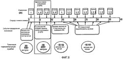
Фиг.8 - гипотетический случай, когда после захвата лишь 2 спутников можно получить усовершенствованное исходное положение до получения измерений от 3 разных спутников.Fig. 8 is a hypothetical case when, after capturing only 2 satellites, it is possible to obtain an improved initial position before receiving measurements from 3 different satellites.
Фиг.9 - гипотетический случай, когда время GPS невозможно получить раньше, чем около 20 секунд после начала сеанса.Fig.9 is a hypothetical case when the GPS time cannot be obtained earlier than about 20 seconds after the start of the session.
ПОДРОБНОЕ ОПИСАНИЕDETAILED DESCRIPTION
Подробное описание, приведенное ниже совместно с прилагаемыми чертежами, призвано описывать различные варианты осуществления настоящего изобретения и не призвано представлять только варианты осуществления, в которых настоящее изобретение можно осуществлять на практике. Каждый вариант осуществления, описанный в этом раскрытии, представляет собой лишь пример или иллюстрацию настоящего изобретения и не обязательно является предпочтительным или преимущественным над другими вариантами осуществления. Подробное описание включает в себя конкретные детали в целях обеспечения полного понимания настоящего изобретения. Однако специалистам в данной области техники очевидно, что настоящее изобретение можно осуществлять на практике без этих конкретных деталей. В ряде случаев общеизвестные структуры и устройства показаны в виде блок-схемы, чтобы не затемнять принципы настоящего изобретения. Акронимы и другие специальные термины могут использоваться лишь для удобства и ясности и не призваны ограничивать объем изобретения. Кроме того, в целях этого раскрытия термин "присоединенный" означает "подключенный", и такое подключение может быть прямым, когда это применимо в контексте, или косвенным, например, через промежуточные или переходные устройства и другие средства.The detailed description below, together with the accompanying drawings, is intended to describe various embodiments of the present invention and is not intended to represent only embodiments in which the present invention can be practiced. Each embodiment described in this disclosure is only an example or illustration of the present invention and is not necessarily preferred or advantageous over other embodiments. The detailed description includes specific details in order to provide a thorough understanding of the present invention. However, it will be apparent to those skilled in the art that the present invention can be practiced without these specific details. In some cases, well-known structures and devices are shown in block diagram form in order not to obscure the principles of the present invention. Acronyms and other special terms can be used only for convenience and clarity and are not intended to limit the scope of the invention. In addition, for the purposes of this disclosure, the term “connected” means “connected”, and such a connection may be direct, when applicable in the context, or indirect, for example, through intermediate or transition devices and other means.
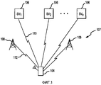
Согласно фиг.1, мобильное устройство 104 может иметь вид любого из различных мобильных приемников, способных принимать навигационные сигналы (например, навигационные сигналы 110 спутников или сигналы 112 беспроводной связи) от опорных станций, например спутников 106 и/или базовых станций 108, для вычисления решения относительно положения. Примеры включают в себя мобильный телефон, карманный навигационный приемник, приемник, установленный на транспортном средстве, например самолете, автомобиле, грузовике, танке, корабле и т.п. Базовые станции 108 могут осуществлять связь с мобильным устройством 104 согласно любому из нескольких протоколов беспроводной связи. Один распространенный протокол беспроводной связи представляет собой протокол множественного доступа с кодовым разделением (CDMA), в котором мобильная связь одновременно осуществляется в радиочастотном (РЧ) спектре. В среде CDMA, методы можно рассматривать как механизм расширенной усовершенствованной трилатерации на основе сигналов прямой линии связи (AFLT). Другие примеры включают в себя Глобальную систему мобильной связи (GSM), в которой используется узкополосный режим множественного доступа с временным разделением (TDMA) для передачи данных, и общая радиослужба пакетной передачи (GPRS). В некоторых вариантах осуществления, мобильное устройство 104 может объединять в себе приемник GPS и устройство беспроводной связи для передачи речи или данных. Таким образом, хотя в этом документе описан конкретный пример системы GPS, принципы и подходы настоящего изобретения применимы к любой спутниковой системе определения положения или наземной системе определения положения, например беспроводной сети.1, the
Мобильное устройство 104 вычисляет решение определения положения на основании сигналов 110, 112, принятых от спутников 106 и базовых станций 108, соответственно. Мобильное устройство 104 принимает сигналы 110 со спутников 106, находящихся в пределах прямой видимости, и измеряет расстояние от каждого спутника путем измерения времени, необходимого для распространения каждого сигнала от соответствующего спутника к мобильному устройству 104, для определения измерения псевдодальности. Аналогично, мобильное устройство 104 также может принимать сигналы 112 от базовых станций 108 системы беспроводной связи 107 и измерять расстояния от базовых станций 108 на основании времени, необходимого для распространения каждого беспроводного сигнала от базовых станций к мобильному устройству. Мобильное устройство 104 обычно находит переменные положения и времени на основании измерений.
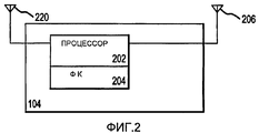
На фиг.2 показана блок-схема участков устройства мобильной связи 104 согласно принципам изобретения, которые относятся к определению положения мобильного устройства 104. Мобильное устройство 104 может включать в себя антенну 220, способную принимать сигналы от спутниковой навигационной системы или спутниковой системы определения положения, и другую антенну 206, способную принимать сигналы от наземной сети связи. Эти сигналы поступают на процессор 202, который включает в себя программные и аппаратные компоненты, обеспечивающие функции обработки сигнала в отношении сигналов. В частности, фильтр Калмана 204 реализован в составе мобильного устройства 104, который осуществляет функции определения положения мобильного устройства 104.FIG. 2 shows a block diagram of portions of a
Как известно из уровня техники, фильтр определения положения, например фильтр Калмана 204, принимает входные измерения и реализует алгоритм нахождения нужных переменных на основании входных измерений и исторического состояния системы. Память, хотя и не показана, часто используется для хранения информации состояния и значений ковариационной матрицы для фильтра Калмана, которые обеспечивают меру ошибки, или определенности, оценок состояния, обеспечиваемых фильтром Калмана.As is known from the prior art, a position determination filter, such as a
Мобильное устройство 104 может представлять собой, например, сотовый телефон или аналогичное устройство мобильной связи. Соответственно, существуют дополнительные функциональные блоки и устройства, которые являются частью мобильного устройства 104, которые не показаны на фиг.2. Эти дополнительные блоки и/или устройства обычно связаны с обработкой сигналов, поступающих от антенн 206, 220; обеспечением пользовательского интерфейса, обеспечением речевой связи; обеспечением передачи данных и другими аналогичными функциями. Многие из этих функциональных блоков и устройств не связаны непосредственно с определением положения и поэтому не включены, чтобы не затемнять принципы настоящего изобретения.
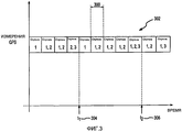
Как было кратко объяснено выше, сигналы обычно принимаются со спутников посредством антенны 220. Затем эти сигналы декодируются и преобразуются в информацию положения с использованием общеизвестных алгоритмов и методов. В прошлом, для генерации засечки положения требовались сигналы от, по меньшей мере, трех спутников в течение одного периода измерения, с использованием модели взвешенных наименьших квадратов (WLS), которую можно использовать для инициализации фильтра Калмана 204. После инициализации фильтра Калмана можно продолжать вырабатывать оценки положения на основании дальнейших измерений GPS. На фиг.3 показан сценарий, в котором измерения GPS 302 (от 1, 2 или 3 спутников) принимаются в течение отдельных периодов измерения 300 и ни одно из самых ранних измерений не включает в себя одновременные сигналы от трех разных спутников. Таким образом, несмотря на постоянное получение сигналов, которые включают в себя информацию положения, фильтр Калмана, используемый ранее, невозможно было инициализировать до получения измерений GPS от трех разных спутников в течение одного периода измерения (что обычно происходит в момент 306).As was briefly explained above, signals are usually received from satellites via
Напротив, варианты осуществления настоящего изобретения предусматривают использование информации определения положения, полученной в течение разных периодов измерения, для инициализации фильтра Калмана. Таким образом, три разных измерения из множественных неодновременных периодов измерения доступны в момент 304 (значительно более ранний, чем момент 306), и фильтр Калмана способен обеспечивать засечку хорошего качества в более ранний момент времени. Предыдущее объяснение опирается на предположение, что для генерации засечки положения приемника требуются только три спутниковых сигнала измерения. Это предположение базируется на информации высоты, которая доступна из альтернативных источников, например сети связи и пр. Альтернативно, если информация высоты недоступна, тот же принцип применяется для четырех спутников, вместо трех.In contrast, embodiments of the present invention provide for using position determination information obtained during different measurement periods to initialize a Kalman filter. Thus, three different measurements from multiple non-simultaneous measurement periods are available at time 304 (much earlier than 306), and the Kalman filter is able to provide good quality notch at an earlier point in time. The previous explanation is based on the assumption that only three satellite measurement signals are required to generate a notch of the receiver position. This assumption is based on altitude information that is available from alternative sources, such as a communications network, etc. Alternatively, if altitude information is not available, the same principle applies for four satellites, instead of three.
Еще до того как станут доступны три спутниковых измерения определения положения, варианты осуществления настоящего изобретения могут использовать два измерения для значительного улучшения оценки на основании начального положения. Например, используя измерения от двух спутников, можно обеспечить оценку горизонтального положения, которая обычно, по меньшей мере, на 30% точнее начального положения и часто находится в пределах 100-500 метров.Before three satellite position measurements are available, embodiments of the present invention can use two measurements to significantly improve estimates based on the starting position. For example, using measurements from two satellites, it is possible to provide an estimate of the horizontal position, which is usually at least 30% more accurate than the initial position and often within 100-500 meters.
На фиг.4 показана логическая блок-схема иллюстративного способа использования разных спутниковых измерений для обеспечения информации положения согласно принципам настоящего изобретения. На этапе 402, мобильное устройство начинает получать любую информацию, позволяющую определить положение, которая доступна из сети связи или из памяти. Например, высота в пределах 50 метров может быть доступна, как и положение в пределах нескольких сотен метров, при наличии вспомогательной системы GPS. Затем, на этапе 404, эта информация используется для инициализации состояния фильтра Калмана и ковариационной матрицы. Фильтр Калмана способен обеспечивать прогнозирование положения и скорости, а также корректировать предыдущий прогноз для обеспечения текущих положения и скорости. Таким образом, сеть связи, память устройства или другие источники могут обеспечивать начальное положение и оценки ошибки, которые задают начальное состояние фильтра Калмана.Figure 4 shows a logical block diagram of an illustrative method of using different satellite measurements to provide position information in accordance with the principles of the present invention. At step 402, the mobile device begins to receive any information that allows you to determine the position that is available from the communication network or from memory. For example, a height within 50 meters may be available, as well as a position within a few hundred meters, with an auxiliary GPS system. Then, at step 404, this information is used to initialize the state of the Kalman filter and the covariance matrix. The Kalman filter is capable of predicting position and speed, as well as adjusting the previous forecast to provide current position and speed. Thus, a communication network, device memory, or other sources can provide an initial position and error estimates that specify the initial state of the Kalman filter.
Затем, на этапе 406, состояние фильтра Калмана и ковариационная матрица обновляются любой информацией положения, полученной от любого спутника. Например, если положение мобильного устройства на относительно малом участке земной поверхности (например, в секторе соты беспроводной сети) известно, то информацию псевдодальности от двух спутников можно использовать для идентификации сравнительно короткого прямолинейного отрезка, на котором располагается мобильное устройство. В порядке внутренней работы фильтра Калмана, ковариационные матрицы автоматически обновляются, и эти обновления отражают новую оценку ошибки для прогнозируемых значений. Таким образом, фильтр Калмана обеспечивает оценку, например, на этапе 408 широты и долготы мобильного устройства совместно с оценкой ошибки или неопределенности. Кроме того, фильтр Калмана обеспечивает высоту мобильного устройства. На этапе 409 производится тестирование для определения, отвечают ли оценочные ошибки требованиям приложения. Если да, осуществляется переход к этапу 410, на котором приложению передаются оценочные значения широты, долготы и высоты. Если нет, осуществляется возврат к этапу 406. Специалисту в данной области техники очевидно, что различные математические манипуляции и преобразования координат можно осуществлять, чтобы гарантировать надлежащий формат загружаемой и обновляемой информации о состоянии и ковариационных матриц.Then, at step 406, the state of the Kalman filter and the covariance matrix are updated with any position information received from any satellite. For example, if the position of the mobile device on a relatively small portion of the earth’s surface (for example, in the cell sector of a wireless network) is known, then the pseudorange information from the two satellites can be used to identify the relatively short straight line segment on which the mobile device is located. In order of the internal operation of the Kalman filter, the covariance matrices are automatically updated, and these updates reflect a new error estimate for the predicted values. Thus, the Kalman filter provides an estimate, for example, at 408 of the latitude and longitude of the mobile device, together with an estimate of error or uncertainty. In addition, the Kalman filter provides the height of the mobile device. At 409, testing is performed to determine if the estimated errors meet the requirements of the application. If so, proceeds to step 410, where the estimated latitude, longitude, and altitude values are transmitted to the application. If not, it returns to step 406. It will be apparent to those skilled in the art that various mathematical manipulations and coordinate transformations can be performed to guarantee the proper format for the downloaded and updated status information and covariance matrices.
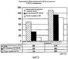
На фиг.5 показана диаграмма, демонстрирующая повышение производительности благодаря использованию моделирования методом Монте-Карло, объединенного по множественным местам. Горизонтальная ошибка (HE) для 68-го процентиля снижается с 333 м для WLS до 124 м для сшивания ФК. HE для 95-го процентиля снижается с 942 м для WLS до 838 м для сшивания ФК.Fig. 5 is a diagram showing a performance increase due to the use of Monte Carlo simulations combined in multiple places. The horizontal error (HE) for the 68th percentile decreases from 333 m for WLS to 124 m for crosslinking. HE for the 95th percentile is reduced from 942 m for WLS to 838 m for crosslinking of FC.
Согласно фиг.3, измерения GPS из последовательных периодов можно использовать для уменьшения ошибки (через фильтр Калмана) даже в отсутствие данных от других спутников. Таким образом, например, фильтр Калмана может использовать два соседних измерения от спутника "1" даже в отсутствие информации от другого спутника. В конечном итоге, при получении информации от дополнительных спутников оценку от фильтра Калмана можно обновлять, соответственно, несмотря на то, что измерения не были приняты в течение одного и того же периода измерения. Наконец, после достаточного количества обновлений, фильтр Калмана сможет предсказать положение и скорость на уровне неопределенности, приемлемом для приложения.According to figure 3, GPS measurements from successive periods can be used to reduce errors (through the Kalman filter) even in the absence of data from other satellites. Thus, for example, the Kalman filter can use two adjacent measurements from satellite "1" even in the absence of information from another satellite. Ultimately, when receiving information from additional satellites, the estimate from the Kalman filter can be updated, respectively, despite the fact that the measurements were not taken during the same measurement period. Finally, after a sufficient number of updates, the Kalman filter will be able to predict the position and speed at the level of uncertainty acceptable for the application.
Дополнительное уточнение усовершенствованного способа сшивания фильтров Калмана показано на фиг.6. Верхняя схема иллюстрирует традиционный сценарий временной шкалы измерения GPS для мобильного приемника, где фильтр Калмана невозможно инициализировать без, по меньшей мере, 3 одновременных измерений GPS. Засечка положения методом WLS с использованием 3 спутников необходима для запуска процесса оценивания ФК, который в этом гипотетическом примере происходит примерно через 30 секунд после начала сеанса. Затем ФК продолжает обновлять засечки положения, даже если в данный период доступно менее 3 спутниковых измерений. Напротив, нижняя схема показывает сценарий временной шкалы измерения GPS согласно изобретению, где фильтр Калмана может вырабатывать решение относительно положения с качеством, типичным для GPS, при наличии 3 неодновременных измерений GPS с использованием возможностей "сшивания", предусмотренных настоящим изобретением. В этом случае, процесс оценивания ФК начинается примерно через 10 секунд после начала сеанса, когда, по меньшей мере, 3 спутника успешно наблюдаются, хотя и в разные периоды. Кроме того, после этой успешной инициализации ФК продолжает обновлять засечки положения, даже если в данный период доступно менее 3 спутниковых измерений.Further refinement of an improved method for stitching Kalman filters is shown in FIG. 6. The top diagram illustrates a traditional GPS timeline scenario for a mobile receiver, where the Kalman filter cannot be initialized without at least 3 simultaneous GPS measurements. A position notch using the WLS method using 3 satellites is necessary to start the FC estimation process, which in this hypothetical example occurs approximately 30 seconds after the start of the session. Then the FC continues to update the position cut-offs, even if less than 3 satellite measurements are available in a given period. In contrast, the bottom diagram shows a GPS measurement timeline scenario according to the invention, where the Kalman filter can decide on a position with a quality typical of GPS when there are 3 non-simultaneous GPS measurements using the “stitching” capabilities of the present invention. In this case, the FC estimation process begins approximately 10 seconds after the start of the session, when at least 3 satellites are successfully observed, although at different periods. In addition, after this successful initialization, the FC continues to update position fixes, even if less than 3 satellite measurements are available during this period.
Таким образом, усовершенствованный способ сшивания ФК, проиллюстрированный выше, позволяет значительно сократить время до первой засечки для мобильных приемников GPS в неблагоприятных условиях распространения сигнала. Кроме того, как описано выше, можно добиться повышенной точности определения горизонтального положения.Thus, the improved method of stitching the FC, illustrated above, can significantly reduce the time to the first notch for mobile GPS receivers in adverse propagation conditions of the signal. In addition, as described above, it is possible to achieve increased accuracy in determining the horizontal position.
Еще одно преимущество этого изобретения состоит в улучшенном получении решения в неблагоприятных условиях распространения сигнала. Например, на фиг.7 показан тот же гипотетический пример, что и на фиг.6, но с добавлением гипотетического тайм-аута сеанса в 16 секунд. Традиционная засечка положения на основании оценки WLS не достигает правильного положения до засечки тайм-аут вследствие ее задержки около 30 секунд. С другой стороны, начальная засечка положения на основании сшивания ФК согласно этому изобретению может достигать правильной засечки за время, меньшее предела тайм-аута. Таким образом, этот способ может обеспечивать более высокую вероятность успешной засечки положения для мобильных приемников GPS в трудных условиях распространения сигнала.Another advantage of this invention is the improved solution in adverse propagation conditions. For example, FIG. 7 shows the same hypothetical example as in FIG. 6, but with the addition of a hypothetical session timeout of 16 seconds. The traditional position fix based on the WLS estimate does not reach the correct position before the cutoff timeout due to its delay of about 30 seconds. On the other hand, the initial position notch based on the stitching of the PK according to this invention can achieve the correct notch in a time shorter than the timeout limit. Thus, this method can provide a higher likelihood of a successful position fix for mobile GPS receivers in difficult propagation conditions.
Другим аспектом этого изобретения является улучшение в неопределенности исходного положения с использованием линии положения 2-GPS. На фиг.8 показан гипотетический случай, когда после захвата лишь 2 спутников можно получить усовершенствованное исходное положение до получения измерений от 3 разных спутников. Эта особенность основана на геометрическом свойстве, состоящем в том, что определение трехмерного положения, имеющее два правильных измерения псевдодальности плюс высота, приводит к одномерной линии решения относительно положения. Это решение имеет только одну остаточную степень свободы по сравнению с полной засечкой положения, что приводит к снижению линейно неопределенности и существенному снижению неопределенности по площади по сравнению с исходным положением.Another aspect of this invention is the improvement in the uncertainty of the starting position using the 2-GPS position line. Fig. 8 shows a hypothetical case where, after capturing only 2 satellites, it is possible to obtain an improved initial position before obtaining measurements from 3 different satellites. This feature is based on the geometric property that the definition of a three-dimensional position, having two correct measurements of pseudorange plus height, leads to a one-dimensional solution line relative to the position. This solution has only one residual degree of freedom compared to a complete notch of position, which leads to a decrease in linear uncertainty and a significant reduction in uncertainty over the area compared to the initial position.
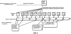
Еще один пример преимуществ этого изобретения состоит в том, что, если точное время GPS неизвестно в начале сеанса, можно использовать обратное распространение для использования прежних, сохраненных, измерений после получения точного времени GPS (с точностью до долей миллисекунды). Например, на фиг.9 показан гипотетический случай, когда время GPS невозможно получить раньше, чем около 20 секунд после начала сеанса. Другими словами, первый набор измерений дальности GPS можно получить и сохранить, но не сразу использовать, из-за недостатка информации время GPS. После определения времени GPS устанавливается соотношение между местным временем и временем GPS, после чего ранее сохраненные измерения GPS можно связать с точным временем GPS и обработку обратного распространения можно использовать для извлечения ранее сохраненных данных для усовершенствованного определения положения. Таким образом, обратное распространение позволяет приемнику GPS полностью использовать все правильные спутниковые измерения GPS, даже если время GPS не получено сразу, что приводит к повышению производительности и точности.Another example of the advantages of this invention is that if the exact GPS time is not known at the beginning of the session, you can use back propagation to use the previous, saved, measurements after obtaining the exact GPS time (accurate to a fraction of a millisecond). For example, FIG. 9 shows a hypothetical case where the GPS time cannot be obtained earlier than about 20 seconds after the start of the session. In other words, the first set of GPS range measurements can be obtained and saved, but not immediately used, due to lack of information, GPS time. After determining the GPS time, a relationship is established between local time and GPS time, after which previously saved GPS measurements can be associated with the exact GPS time and back propagation processing can be used to extract previously stored data for improved positioning. Thus, backpropagation allows the GPS receiver to fully utilize all the correct GPS satellite measurements, even if GPS time is not immediately obtained, resulting in improved performance and accuracy.
Еще один пример преимуществ этого изобретения состоит в том, что, если точные эфемеридные данные спутника недоступны в начале сеанса, можно использовать обратное распространение для использования прежних, сохраненных, измерений после получения точных эфемерид. После получения эфемеридных данных положение спутника известно, и затем ранее сохраненные измерения GPS можно связать с точными эфемеридными данными спутника и обработку обратного распространения можно использовать для извлечения ранее сохраненных данных для усовершенствованного определения положения. Таким образом, обратное распространение позволяет приемнику GPS полностью использовать все правильные спутниковые измерения GPS, даже если эфемеридные данные спутника не получены сразу, что приводит к повышению производительности и точности.Another example of the advantages of this invention is that if accurate satellite ephemeris data are not available at the start of the session, back propagation can be used to use the previous, saved measurements after obtaining the exact ephemeris. After receiving the ephemeris data, the position of the satellite is known, and then previously stored GPS measurements can be associated with accurate satellite ephemeris data, and backpropagation processing can be used to extract previously stored data for improved positioning. Thus, backpropagation allows the GPS receiver to fully utilize all the correct GPS satellite measurements, even if the ephemeris data of the satellite are not immediately received, resulting in improved performance and accuracy.
На практике, информация положения фильтра Калмана передается, на этапе 410, одному или нескольким приложениям, которые могут выполняться на мобильном устройстве. Например, службы на основе положения, например местная служба погоды, могут использовать оценки положения с неопределенностью порядка километра или более. Напротив, службы "911" могут требовать, чтобы определенность оценок положения достигала 50 метров или менее. Соответственно, оценки положения (и скорости) можно передавать приложениями совместно с любыми оценками неопределенности или ошибки. Таким образом, каждое приложение может выбирать, достаточна ли оценка положения от фильтра Калмана для его требований.In practice, the position information of the Kalman filter is transmitted, at step 410, to one or more applications that can run on a mobile device. For example, location-based services, such as a local weather service, may use position estimates with uncertainties of the order of a kilometer or more. In contrast, 911 services may require certainty of position estimates to reach 50 meters or less. Accordingly, position (and speed) estimates can be transmitted by applications in conjunction with any estimates of uncertainty or error. Thus, each application can choose whether the position estimate from the Kalman filter is sufficient for its requirements.
Описанные здесь методы вещания разных типов передачи в эфире можно реализовать различными средствами. Например, эти методы можно реализовать в оборудовании, программном обеспечении или их комбинации. Для аппаратной реализации, устройства обработки на базовой станции, используемой для вещания разных типов передачи, можно реализовать в одной(м) или нескольких специализированных интегральных схемах (ASIC), цифровых сигнальных процессорах (DSP), устройствах цифровой обработки сигнала (DSPD), программируемых логических устройствах (PLD), вентильных матрицах, программируемых пользователем (FPGA), процессорах, контроллерах, микроконтроллерах, микропроцессорах, других электронных устройствах, способных осуществлять описанные здесь функции, или их комбинациях. Устройства обработки на беспроводном устройстве, используемом для приема разных типов передачи, также можно реализовать в одной(м) или нескольких ASIC, DSP и т.д.The broadcasting methods described here for different types of broadcasts can be implemented by various means. For example, these methods can be implemented in hardware, software, or a combination thereof. For hardware implementation, the processing device at the base station used for broadcasting different types of transmission can be implemented in one (m) or several specialized integrated circuits (ASIC), digital signal processors (DSP), digital signal processing devices (DSPD), programmable logic devices (PLDs), user-programmable gate arrays (FPGAs), processors, controllers, microcontrollers, microprocessors, other electronic devices capable of performing the functions described here, or their mbinatsiyah. Processing devices on a wireless device used to receive different types of transmission can also be implemented in one (m) or several ASICs, DSPs, etc.
Для программной реализации, описанные здесь методы можно реализовать посредством модулей (например, процедур, функций и т.д.), которые осуществляют описанные здесь функции. Программные коды могут храниться в запоминающем устройстве и выполняться процессором. Запоминающее устройство можно реализовать в процессоре или вне процессора, в каковом случае оно может присоединяться к процессору с возможностью обмена данными через различные средства, известные в технике.For a software implementation, the methods described here can be implemented using modules (e.g., procedures, functions, etc.) that perform the functions described here. Software codes may be stored in a memory device and executed by a processor. The storage device can be implemented in the processor or outside the processor, in which case it can be connected to the processor with the ability to exchange data through various means known in the art.
Вышеприведенное описание позволяет специалистам в данной области техники применять на практике различные описанные здесь варианты осуществления. Специалисту в данной области должны быть очевидны различные модификации этих вариантов осуществления, и раскрытые здесь общие принципы можно применять к другим вариантам осуществления. Таким образом, формула изобретения не должна ограничиваться представленными здесь вариантами осуществления, но подлежит рассмотрению в полном объеме, согласующемся с языком формулы изобретения, где упоминание элемента в единственном числе не означает "один и только один", если конкретно не указано обратное, но означает "один или несколько." Все структурные и функциональные эквиваленты элементов различных вариантов осуществления, описанных в этом раскрытии, которые известны или станут известны позже специалистам в данной области техники, в явном виде включены сюда посредством ссылки и подлежат охвату формулой изобретения. Кроме того, раскрытая здесь информация не подлежит публичному оглашению независимо от того, упомянуто ли явно такое раскрытие в формуле изобретения. Ни один элемент формулы изобретения не подлежит толкованию согласно положениям 35 U.S.C. §112, параграф шесть, если элемент не упомянут явно с использованием выражения "средство для", или, применительно к пункту способа, элемент не упомянут с использованием выражения "этап, на котором".The above description allows those skilled in the art to practice the various embodiments described herein. Various modifications to these embodiments will be apparent to those skilled in the art, and the general principles disclosed herein can be applied to other embodiments. Thus, the claims should not be limited to the embodiments presented here, but should be considered in full, consistent with the language of the claims, where the mention of the element in the singular does not mean "one and only one" unless specifically indicated otherwise, but means " one or more. " All structural and functional equivalents of the elements of the various embodiments described in this disclosure that are known or will become known to those skilled in the art are expressly incorporated herein by reference and are intended to be covered by the claims. In addition, the information disclosed herein is not publicly disclosed, regardless of whether such disclosure is explicitly mentioned in the claims. No element of the claims is construed in accordance with the provisions of 35 U.S.C. §112, paragraph six, if the element is not explicitly mentioned using the expression "means for", or, in relation to the method point, the element is not mentioned using the expression "stage where".
Claims (40)
Applications Claiming Priority (2)
| Application Number | Priority Date | Filing Date | Title |
|---|---|---|---|
| US77993506P | 2006-03-06 | 2006-03-06 | |
| US60/779,935 | 2006-03-06 |
Related Child Applications (1)
| Application Number | Title | Priority Date | Filing Date |
|---|---|---|---|
| RU2010122371/07A Division RU2543618C2 (en) | 2006-03-06 | 2007-03-06 | Method to determine position by linkage of measurements |
Publications (2)
| Publication Number | Publication Date |
|---|---|
| RU2008139422A RU2008139422A (en) | 2010-04-20 |
| RU2413959C2 true RU2413959C2 (en) | 2011-03-10 |
Family
ID=39033535
Family Applications (2)
| Application Number | Title | Priority Date | Filing Date |
|---|---|---|---|
| RU2008139422/09A RU2413959C2 (en) | 2006-03-06 | 2007-03-06 | Method for position finding by cross linking measurements |
| RU2010122371/07A RU2543618C2 (en) | 2006-03-06 | 2007-03-06 | Method to determine position by linkage of measurements |
Family Applications After (1)
| Application Number | Title | Priority Date | Filing Date |
|---|---|---|---|
| RU2010122371/07A RU2543618C2 (en) | 2006-03-06 | 2007-03-06 | Method to determine position by linkage of measurements |
Country Status (9)
| Country | Link |
|---|---|
| US (2) | US9354321B2 (en) |
| EP (2) | EP1991883A2 (en) |
| JP (2) | JP5425478B2 (en) |
| KR (2) | KR101216551B1 (en) |
| CN (2) | CN102866410B (en) |
| BR (1) | BRPI0708496B1 (en) |
| CA (1) | CA2641335C (en) |
| RU (2) | RU2413959C2 (en) |
| WO (1) | WO2008019172A2 (en) |
Families Citing this family (38)
| Publication number | Priority date | Publication date | Assignee | Title |
|---|---|---|---|---|
| US9354321B2 (en) * | 2006-03-06 | 2016-05-31 | Qualcomm Incorporated | Method for position determination with measurement stitching |
| US20080180315A1 (en) * | 2007-01-26 | 2008-07-31 | Sige Semiconductor (Europe) Limited | Methods and systems for position estimation using satellite signals over multiple receive signal instances |
| US7586441B2 (en) * | 2007-06-27 | 2009-09-08 | Mediatek Inc. | Methods and apparatuses for searching for satellite signals |
| US8368588B2 (en) * | 2007-11-26 | 2013-02-05 | Mediatek Inc. | Method and apparatus for updating transformation information parameters used in global navigation satellite system |
| JP4470994B2 (en) * | 2007-12-14 | 2010-06-02 | トヨタ自動車株式会社 | Audio system for vehicles |
| US20100090893A1 (en) * | 2008-10-09 | 2010-04-15 | Takayuki Hoshizaki | User based positioning aiding network by mobile GPS station/receiver |
| GB2469444A (en) * | 2009-04-14 | 2010-10-20 | Vodafone Plc | Terminal positioning |
| US9074897B2 (en) * | 2009-06-15 | 2015-07-07 | Qualcomm Incorporated | Real-time data with post-processing |
| US8838132B2 (en) * | 2009-08-12 | 2014-09-16 | Qualcomm Incorporated | Enhanced positioning assistance data for reduced signaling |
| EP2561635B1 (en) * | 2010-04-20 | 2016-06-22 | Telefonaktiebolaget LM Ericsson (publ) | Method and arrangement of increasing impairment co-variance matrix estimation accuracy |
| US8704707B2 (en) | 2010-06-02 | 2014-04-22 | Qualcomm Incorporated | Position determination using measurements from past and present epochs |
| US9052202B2 (en) | 2010-06-10 | 2015-06-09 | Qualcomm Incorporated | Use of inertial sensor data to improve mobile station positioning |
| GB2491547A (en) * | 2010-07-15 | 2012-12-12 | Peepo Gps Ltd | A guidance device using fixed and mobile transmitters |
| US20120046863A1 (en) * | 2010-08-12 | 2012-02-23 | The Government Of The Us, As Represented By The Secretary Of The Navy | Orbit covariance, estimation and analysis tool |
| US9031572B2 (en) * | 2010-12-22 | 2015-05-12 | Qualcomm Incorporated | Method and apparatus for estimating satellite positioning reliability |
| US20120249373A1 (en) * | 2011-01-17 | 2012-10-04 | Qualcomm Incorporated | Populating Non-Positional Transmitter Location Databases Using Information about Recognized Positional Transmitters |
| JP5742450B2 (en) * | 2011-05-10 | 2015-07-01 | セイコーエプソン株式会社 | Position calculation method and position calculation apparatus |
| US10386490B2 (en) | 2012-07-16 | 2019-08-20 | Microsoft Technology Licensing, Llc | Reduced sampling low power GPS |
| US9344990B1 (en) | 2012-12-03 | 2016-05-17 | Sprint Communications Company L.P. | Device location accuracy metrics for applications on wireless communication devices |
| FR3002032B1 (en) * | 2013-02-08 | 2016-02-12 | Dassault Aviat | SYSTEM AND METHOD FOR AIDING NAVIGATION OF AN AIRCRAFT |
| US10126429B2 (en) * | 2013-03-15 | 2018-11-13 | etherwhere Corporation | Method and apparatus for determining device location |
| WO2014149042A1 (en) * | 2013-03-20 | 2014-09-25 | International Truck Intellectual Property Company, Llc | Smart cruise control system |
| US10317538B2 (en) | 2013-08-27 | 2019-06-11 | Microsoft Technology Licensing, Llc | Cloud-offloaded global satellite positioning |
| US9671499B2 (en) * | 2013-10-30 | 2017-06-06 | Microsoft Technology Licensing, Llc | High-sensitivity GPS device with directional antenna |
| JP5794646B2 (en) * | 2013-12-27 | 2015-10-14 | 日本電気株式会社 | Satellite positioning system, positioning terminal, positioning method, and program |
| WO2015141291A1 (en) | 2014-03-19 | 2015-09-24 | 日産自動車株式会社 | Shared vehicle management device and program |
| US9309631B2 (en) | 2014-03-26 | 2016-04-12 | Caterpillar Trimble Control Technologies Llc | Enhanced control of road construction equipment |
| US9574320B2 (en) * | 2014-03-26 | 2017-02-21 | Trimble Navigation Limited | Blended position solutions |
| US10809365B2 (en) * | 2014-08-25 | 2020-10-20 | Texas Instruments Incorporated | Vibration parameters monitoring using FMCW radar |
| CN104796984B (en) * | 2015-04-29 | 2018-07-13 | 百度在线网络技术(北京)有限公司 | Base station positioning method and device |
| EP3109673B1 (en) * | 2015-06-24 | 2020-01-08 | Centre National d'Etudes Spatiales | Gnss receiver with an improved capability to resolve sub-carrier tracking ambiguities |
| EP3109671B1 (en) * | 2015-06-24 | 2018-12-05 | Centre National d'Etudes Spatiales | Device for tracking a satellite radionavigation signal in a multipath environment |
| CN105699998A (en) * | 2016-01-13 | 2016-06-22 | 广东欧珀移动通信有限公司 | Mobile terminal positioning method and apparatus thereof, and mobile terminal |
| US10670732B2 (en) * | 2016-03-31 | 2020-06-02 | Apple Inc. | Navigation device and method for determining navigation information |
| US10274607B2 (en) * | 2016-09-13 | 2019-04-30 | Qualcomm Incorporated | Fast recovery from incorrect carrier phase integer locking |
| DE102016218655A1 (en) * | 2016-09-28 | 2018-03-29 | Airbus Defence and Space GmbH | Batch processing for GNSS signal processing in a user satellite |
| US11353566B2 (en) * | 2018-04-26 | 2022-06-07 | Navico Holding As | Sonar transducer having a gyroscope |
| US11617059B1 (en) | 2021-05-28 | 2023-03-28 | T-Mobile Usa, Inc. | Mobile device geographic location determination for emergency services |
Family Cites Families (108)
| Publication number | Priority date | Publication date | Assignee | Title |
|---|---|---|---|---|
| GB2215932A (en) * | 1988-03-26 | 1989-09-27 | Gec Traffic Automation | Radio position finding system |
| AU642638B2 (en) | 1989-12-11 | 1993-10-28 | Caterpillar Inc. | Integrated vehicle positioning and navigation system, apparatus and method |
| US5452211A (en) * | 1992-08-10 | 1995-09-19 | Caterpillar Inc. | Method and system for determining vehicle position |
| US5646857A (en) * | 1995-03-31 | 1997-07-08 | Trimble Navigation Limited | Use of an altitude sensor to augment availability of GPS location fixes |
| US5508708A (en) * | 1995-05-08 | 1996-04-16 | Motorola, Inc. | Method and apparatus for location finding in a CDMA system |
| AU7396596A (en) * | 1995-10-09 | 1997-04-30 | Precision Tracking, Inc. | Method and apparatus for determining the location of an object which may have an obstructed view of the sky |
| US6133871A (en) * | 1995-10-09 | 2000-10-17 | Snaptrack, Inc. | GPS receiver having power management |
| DE69638262D1 (en) * | 1995-10-09 | 2010-10-28 | Snaptrack Inc | GPS receiver and method for processing GPS signals |
| FR2741159B1 (en) | 1995-11-14 | 1998-01-23 | Centre Nat Etd Spatiales | GLOBAL SPATIAL RADIO-LOCATION AND RADIONAVIGATION SYSTEM, BEACON, AND RECEIVER USED IN SUCH A SYSTEM |
| US5774829A (en) * | 1995-12-12 | 1998-06-30 | Pinterra Corporation | Navigation and positioning system and method using uncoordinated beacon signals in conjunction with an absolute positioning system |
| US5862511A (en) * | 1995-12-28 | 1999-01-19 | Magellan Dis, Inc. | Vehicle navigation system and method |
| US6393046B1 (en) * | 1996-04-25 | 2002-05-21 | Sirf Technology, Inc. | Spread spectrum receiver with multi-bit correlator |
| US5884220A (en) * | 1996-07-16 | 1999-03-16 | Trimble Navigation Limited | Method and apparatus to improve overall performance of a DGPS receiver |
| SE506759C2 (en) | 1996-09-30 | 1998-02-09 | Ericsson Telefon Ab L M | Device and method for locating a mobile station in a cellular mobile telephone system |
| US5883594A (en) * | 1997-02-20 | 1999-03-16 | Trimble Navigation Limited | GPS receiver using a message system for reducing power consumption |
| FR2764708B1 (en) * | 1997-06-17 | 1999-09-03 | Dassault Sercel Navigation Pos | IMPROVEMENTS TO REAL-TIME RADIO-SATELLITE LOCATION METHODS AND SYSTEMS, IN PARTICULAR OF THE GPS TYPE |
| US5983159A (en) * | 1997-09-30 | 1999-11-09 | Trimble Navigation | Location determination using signals from fewer than four satellites |
| US6433739B1 (en) * | 1998-03-17 | 2002-08-13 | Qualcomm, Incorporated | Method and apparatus for synchronizing base stations using remote synchronizing stations |
| US6081229A (en) | 1998-03-17 | 2000-06-27 | Qualcomm Incorporated | System and method for determining the position of a wireless CDMA transceiver |
| US5999124A (en) * | 1998-04-22 | 1999-12-07 | Snaptrack, Inc, | Satellite positioning system augmentation with wireless communication signals |
| US6252543B1 (en) * | 1998-05-28 | 2001-06-26 | Ericsson Inc. | Location system combining ranging measurements from GPS and cellular networks |
| KR100264977B1 (en) | 1998-07-02 | 2000-09-01 | 이계철 | Method for the real-time estimation of user position in dgps |
| US6246960B1 (en) | 1998-11-06 | 2001-06-12 | Ching-Fang Lin | Enhanced integrated positioning method and system thereof for vehicle |
| US6449559B2 (en) * | 1998-11-20 | 2002-09-10 | American Gnc Corporation | Fully-coupled positioning process and system thereof |
| US6741863B1 (en) | 1998-12-18 | 2004-05-25 | Lucent Technologies Inc. | Method and apparatus for locating a wireless mobile unit |
| US6331835B1 (en) * | 1999-02-02 | 2001-12-18 | The Charles Stark Draper Laboratory, Inc. | Deeply-integrated adaptive GPS-based navigator with extended-range code tracking |
| US6295024B1 (en) * | 1999-02-19 | 2001-09-25 | Motorola, Inc. | Autonomous data aided GPS signal acquisition method and system |
| US6408178B1 (en) | 1999-03-29 | 2002-06-18 | Ericsson Inc. | Systems and methods for resolving GPS pseudo-range ambiguity |
| US6608589B1 (en) * | 1999-04-21 | 2003-08-19 | The Johns Hopkins University | Autonomous satellite navigation system |
| TW448304B (en) | 1999-04-22 | 2001-08-01 | Lin Ching Fang | Fully-coupled positioning process and system |
| US6225942B1 (en) | 1999-07-30 | 2001-05-01 | Litton Systems, Inc. | Registration method for multiple sensor radar |
| JP4301472B2 (en) | 1999-09-16 | 2009-07-22 | 日本無線株式会社 | GPS receiver |
| US6490456B1 (en) * | 1999-10-12 | 2002-12-03 | Lucent Technologies Inc. | Locating a mobile unit in a wireless time division multiple access system |
| US6731237B2 (en) * | 1999-11-09 | 2004-05-04 | The Charles Stark Draper Laboratory, Inc. | Deeply-integrated adaptive GPS-based navigator with extended-range code tracking |
| US6535833B1 (en) * | 1999-11-22 | 2003-03-18 | Nokia Mobile Phones Ltd. | Method and apparatus for filtering measurements used in a generalized positioning system |
| JP2003520968A (en) | 2000-01-18 | 2003-07-08 | セルガイド リミテッド | Positioning of mobile devices using satellite signals by interference processing combined with signals from stationary beacons |
| US6285316B1 (en) * | 2000-06-02 | 2001-09-04 | Cellguide Ltd. | Locating a mobile unit using signals from both mobile beacons and stationary beacons |
| US6587692B1 (en) * | 2000-03-30 | 2003-07-01 | Lucent Technologies Inc. | Location determination using weighted ridge regression |
| US6489922B1 (en) * | 2000-04-22 | 2002-12-03 | American Gnc Corporation | Passive/ranging/tracking processing method for collision avoidance guidance and control |
| JP2001305210A (en) | 2000-04-25 | 2001-10-31 | Matsushita Electric Works Ltd | Position detection device |
| US6259398B1 (en) * | 2000-05-19 | 2001-07-10 | Sri International | Multi-valued variable ambiguity resolution for satellite navigation signal carrier wave path length determination |
| US6735523B1 (en) * | 2000-06-19 | 2004-05-11 | American Gnc Corp. | Process and system of coupled real-time GPS/IMU simulation with differential GPS |
| JP3721964B2 (en) * | 2000-09-12 | 2005-11-30 | 三菱電機株式会社 | GPS receiver |
| US7613917B1 (en) * | 2000-09-18 | 2009-11-03 | Navteq North America, Llc | Method and system for mass distribution of geographic data for navigation systems |
| EP1203966A3 (en) | 2000-11-01 | 2003-01-29 | Nokia Corporation | Position determination |
| WO2002052225A2 (en) | 2000-12-22 | 2002-07-04 | The Charles Stark Draper Laboratory, Inc. | Geographical navigation using multipath wireless navigation signals |
| US6424914B1 (en) * | 2000-12-26 | 2002-07-23 | American Gnc Corporation | Fully-coupled vehicle positioning method and system thereof |
| US6429809B1 (en) * | 2001-01-30 | 2002-08-06 | Qualcomm Incorporated | Method and apparatus for determining location using a coarse position estimate |
| US6452541B1 (en) * | 2001-02-20 | 2002-09-17 | Motorola, Inc. | Time synchronization of a satellite positioning system enabled mobile receiver and base station |
| US6570530B2 (en) | 2001-03-05 | 2003-05-27 | Qualcomm Incorporated | Method and apparatus providing improved position estimate based on an initial coarse position estimate |
| US6493631B1 (en) * | 2001-05-31 | 2002-12-10 | Mlho, Inc. | Geophysical inertial navigation system |
| US6853909B2 (en) * | 2001-12-03 | 2005-02-08 | Applanix Corporation, Inc | Walking stick navigator for position determination |
| US7813311B2 (en) * | 2002-02-05 | 2010-10-12 | Interdigital Technology Corporation | Method and apparatus for synchronizing base stations |
| US6697736B2 (en) * | 2002-02-06 | 2004-02-24 | American Gnc Corporation | Positioning and navigation method and system thereof |
| US7623871B2 (en) * | 2002-04-24 | 2009-11-24 | Qualcomm Incorporated | Position determination for a wireless terminal in a hybrid position determination system |
| US7460870B2 (en) * | 2002-04-25 | 2008-12-02 | Qualcomm Incorporated | Method and apparatus for location determination in a wireless assisted hybrid positioning system |
| US20040025277A1 (en) * | 2002-08-12 | 2004-02-12 | Timmy Chen | Smoother with a friction sleeve on handle |
| US6664923B1 (en) * | 2002-09-24 | 2003-12-16 | Novatel, Inc. | Position and velocity Kalman filter for use with global navigation satelite system receivers |
| US7660588B2 (en) * | 2002-10-17 | 2010-02-09 | Qualcomm Incorporated | Method and apparatus for improving radio location accuracy with measurements |
| KR100498480B1 (en) * | 2003-01-23 | 2005-07-01 | 삼성전자주식회사 | Method and apparatus for estimating position utilizing GPS satellite signal |
| KR100591751B1 (en) * | 2003-03-06 | 2006-06-22 | 삼성전자주식회사 | Complex navigation system and neural network application method using neural network |
| US6975266B2 (en) | 2003-06-17 | 2005-12-13 | Global Locate, Inc. | Method and apparatus for locating position of a satellite signal receiver |
| US8483717B2 (en) * | 2003-06-27 | 2013-07-09 | Qualcomm Incorporated | Local area network assisted positioning |
| US8971913B2 (en) | 2003-06-27 | 2015-03-03 | Qualcomm Incorporated | Method and apparatus for wireless network hybrid positioning |
| JP4105614B2 (en) * | 2003-09-08 | 2008-06-25 | 測位衛星技術株式会社 | RTK positioning system and positioning method thereof |
| WO2005072458A2 (en) * | 2004-01-28 | 2005-08-11 | Delorme Publishing Company, Inc. | Method and device for processing raw gps data |
| FR2866423B1 (en) * | 2004-02-13 | 2006-05-05 | Thales Sa | DEVICE FOR MONITORING THE INTEGRITY OF THE INFORMATION DELIVERED BY AN INS / GNSS HYBRID SYSTEM |
| US7158882B2 (en) * | 2004-03-01 | 2007-01-02 | Global Locate, Inc | Method and apparatus for locating position of a mobile receiver |
| US7254404B2 (en) * | 2004-04-13 | 2007-08-07 | Global Locate, Inc | Method and apparatus for processing position information in a mobile device |
| JP2005326225A (en) | 2004-05-13 | 2005-11-24 | Sony Corp | Information processor, method, and program |
| US7412248B2 (en) * | 2004-06-15 | 2008-08-12 | Technocom Corporation | System and method for location determination |
| US7528770B2 (en) | 2004-07-15 | 2009-05-05 | Novatel Inc. | Method for positioning using GPS in a restrictive coverage environment |
| US7012564B2 (en) * | 2004-08-05 | 2006-03-14 | Global Locate, Inc. | Method and apparatus for adjusting a measurement cycle in a satellite positioning system signal receiver |
| US8013789B2 (en) * | 2004-10-06 | 2011-09-06 | Ohio University | Systems and methods for acquisition and tracking of low CNR GPS signals |
| EP1869728B1 (en) * | 2005-03-14 | 2014-02-26 | The Alfred E Mann Foundation for Scientific Research | System and method for locating objects and communicating with the same |
| US7395156B2 (en) * | 2005-06-23 | 2008-07-01 | Raytheon Company | System and method for geo-registration with global positioning and inertial navigation |
| KR100769252B1 (en) | 2005-07-04 | 2007-10-23 | 삼성전자주식회사 | System and method for positioning using portable internet signal |
| WO2007004788A1 (en) * | 2005-07-04 | 2007-01-11 | Samsung Electronics Co., Ltd. | Position measuring system and method using wireless broadband (wibro) signal |
| US7474962B2 (en) * | 2005-07-13 | 2009-01-06 | Honeywell International Inc. | Methods and systems of relative navigation for shipboard landings |
| KR100742612B1 (en) | 2005-08-19 | 2007-07-25 | 한국전자통신연구원 | Apparatus and Method for Complex Navigation Using Dead Reckoning and GPS |
| US9354321B2 (en) * | 2006-03-06 | 2016-05-31 | Qualcomm Incorporated | Method for position determination with measurement stitching |
| EP2369360A3 (en) | 2006-03-28 | 2013-12-04 | BlackBerry Limited | Estimating locations of cells and mobile devices |
| EP2047290A2 (en) | 2006-08-01 | 2009-04-15 | Qualcomm Incorporated | System and/or method for providing information updates to a location server |
| US7865299B2 (en) * | 2006-09-14 | 2011-01-04 | Toyota Motor Engineering & Manufacturing North America, Inc. | Method and system for predicting a future position of a vehicle using numerical integration |
| US7626544B2 (en) * | 2006-10-17 | 2009-12-01 | Ut-Battelle, Llc | Robust low-frequency spread-spectrum navigation system |
| US8068984B2 (en) * | 2006-10-17 | 2011-11-29 | Ut-Battelle, Llc | Triply redundant integrated navigation and asset visibility system |
| US8493267B2 (en) * | 2006-11-10 | 2013-07-23 | Qualcomm Incorporated | Method and apparatus for position determination with extended SPS orbit information |
| US7439907B2 (en) * | 2006-11-20 | 2008-10-21 | Sirf Technology Holdihgs, Inc. | Navigation signal receiver trajectory determination |
| US7835863B2 (en) * | 2007-04-18 | 2010-11-16 | Mitac International Corporation | Method and system for navigation using GPS velocity vector |
| US7869948B2 (en) * | 2007-04-27 | 2011-01-11 | Sirf Technology, Inc. | Method and apparatus in positioning without broadcast ephemeris |
| US8260036B2 (en) * | 2007-05-09 | 2012-09-04 | Honeywell International Inc. | Object detection using cooperative sensors and video triangulation |
| US20090287414A1 (en) * | 2007-05-14 | 2009-11-19 | Zupt, Llc | System and process for the precise positioning of subsea units |
| US7855678B2 (en) * | 2007-05-16 | 2010-12-21 | Trimble Navigation Limited | Post-mission high accuracy position and orientation system |
| US7586441B2 (en) * | 2007-06-27 | 2009-09-08 | Mediatek Inc. | Methods and apparatuses for searching for satellite signals |
| JP4976948B2 (en) * | 2007-07-25 | 2012-07-18 | 古野電気株式会社 | Attitude measurement device |
| US20090093959A1 (en) * | 2007-10-04 | 2009-04-09 | Trimble Navigation Limited | Real-time high accuracy position and orientation system |
| US7994971B2 (en) * | 2008-01-09 | 2011-08-09 | Mayflower Communications Company, Inc. | GPS-based measurement of roll rate and roll angle of spinning platforms |
| US9366763B2 (en) * | 2009-02-04 | 2016-06-14 | Qualcomm Incorporated | Method and apparatus for position determination with hybrid SPS orbit data |
| US7940210B2 (en) * | 2008-06-26 | 2011-05-10 | Honeywell International Inc. | Integrity of differential GPS corrections in navigation devices using military type GPS receivers |
| US8134497B2 (en) * | 2008-09-30 | 2012-03-13 | Trimble Navigation Limited | Method and system for location-dependent time-specific correction data |
| US7978130B1 (en) * | 2009-05-01 | 2011-07-12 | Coherent Navigation, Inc. | Practical method for upgrading existing GNSS user equipment with tightly integrated Nav-Com capability |
| US8296065B2 (en) * | 2009-06-08 | 2012-10-23 | Ansaldo Sts Usa, Inc. | System and method for vitally determining position and position uncertainty of a railroad vehicle employing diverse sensors including a global positioning system sensor |
| US9074897B2 (en) * | 2009-06-15 | 2015-07-07 | Qualcomm Incorporated | Real-time data with post-processing |
| EP2339378B1 (en) * | 2009-12-17 | 2013-03-20 | u-blox AG | Hybrid satellite positioning receiver |
| US8704707B2 (en) * | 2010-06-02 | 2014-04-22 | Qualcomm Incorporated | Position determination using measurements from past and present epochs |
| EP2530488B1 (en) * | 2011-06-01 | 2016-04-13 | u-blox AG | Hybrid satellite positioning with prediction |
| US8626198B2 (en) * | 2011-11-16 | 2014-01-07 | Qualcomm Incorporated | Characterizing an indoor structure based on detected movements and/or position locations of a mobile device |
| US8983492B2 (en) * | 2012-06-21 | 2015-03-17 | Qualcomm Incorporated | Methods and apparatuses for affecting a motion model within a mobile device |
-
2007
- 2007-03-06 US US11/682,830 patent/US9354321B2/en active Active
- 2007-03-06 RU RU2008139422/09A patent/RU2413959C2/en active
- 2007-03-06 KR KR1020117002605A patent/KR101216551B1/en active IP Right Grant
- 2007-03-06 EP EP07840141A patent/EP1991883A2/en not_active Ceased
- 2007-03-06 CN CN201210323400.7A patent/CN102866410B/en active Active
- 2007-03-06 WO PCT/US2007/063428 patent/WO2008019172A2/en active Application Filing
- 2007-03-06 CN CN2007800074959A patent/CN101395491B/en active Active
- 2007-03-06 RU RU2010122371/07A patent/RU2543618C2/en active
- 2007-03-06 CA CA2641335A patent/CA2641335C/en active Active
- 2007-03-06 JP JP2008558511A patent/JP5425478B2/en active Active
- 2007-03-06 EP EP11001325A patent/EP2333583A1/en not_active Ceased
- 2007-03-06 BR BRPI0708496-0A patent/BRPI0708496B1/en active IP Right Grant
- 2007-03-06 KR KR1020087024374A patent/KR101042730B1/en active IP Right Grant
-
2009
- 2009-04-16 US US12/425,309 patent/US20100117897A1/en not_active Abandoned
-
2013
- 2013-10-02 JP JP2013207760A patent/JP5778233B2/en active Active
Non-Patent Citations (1)
| Title |
|---|
| Под ред. B.C. ШЕБШАЕВИЧА. Сетевые спутниковые радионавигационные системы, 2-е изд. - М.: Радио и связь, 1993, с.186-211, 235-245, 285-291. * |
Also Published As
| Publication number | Publication date |
|---|---|
| EP1991883A2 (en) | 2008-11-19 |
| KR20110017018A (en) | 2011-02-18 |
| WO2008019172A3 (en) | 2008-06-19 |
| JP5425478B2 (en) | 2014-02-26 |
| EP2333583A1 (en) | 2011-06-15 |
| US9354321B2 (en) | 2016-05-31 |
| CN102866410B (en) | 2015-05-13 |
| JP2014055959A (en) | 2014-03-27 |
| CA2641335A1 (en) | 2008-02-14 |
| US20100117897A1 (en) | 2010-05-13 |
| JP2009529677A (en) | 2009-08-20 |
| RU2010122371A (en) | 2011-12-10 |
| WO2008019172A2 (en) | 2008-02-14 |
| JP5778233B2 (en) | 2015-09-16 |
| KR20080108522A (en) | 2008-12-15 |
| CA2641335C (en) | 2016-08-16 |
| US20070205941A1 (en) | 2007-09-06 |
| KR101216551B1 (en) | 2012-12-31 |
| RU2008139422A (en) | 2010-04-20 |
| CN102866410A (en) | 2013-01-09 |
| CN101395491A (en) | 2009-03-25 |
| BRPI0708496B1 (en) | 2020-02-18 |
| BRPI0708496A2 (en) | 2011-05-31 |
| KR101042730B1 (en) | 2011-06-20 |
| CN101395491B (en) | 2012-10-24 |
| RU2543618C2 (en) | 2015-03-10 |
Similar Documents
| Publication | Publication Date | Title |
|---|---|---|
| RU2413959C2 (en) | Method for position finding by cross linking measurements | |
| KR101183753B1 (en) | Tdoa/gps hybrid wireless location system | |
| JP5522645B2 (en) | Method and apparatus for improving radio positioning accuracy | |
| EP2144079B1 (en) | Method and system for using altitude information in a satellite positioning system | |
| RU2327303C2 (en) | Positioning of wireless communication terminal device in mixed positioning system | |
| US6570529B2 (en) | Autonomous calibration of a wireless-global positioning system | |
| US9316740B2 (en) | Method and system for localizing mobile communications terminals | |
| CN108008426B (en) | Pseudolite based positioning system and method | |
| KR101964241B1 (en) | Method and apparatus for determining a position of a gnss receiver | |
| CN115917251A (en) | Matching of GNSS signals | |
| KR102311606B1 (en) | Apparatus for positioning using satellite information and method thereof | |
| CN118655601A (en) | Positioning method and device | |
| CN117917588A (en) | Local remote GNSS positioning | |
| Sairo | Error Detection in Personal Satellite Navigation |