KR101216551B1 - Method for position determination with measurement stitching - Google Patents
Method for position determination with measurement stitching Download PDFInfo
- Publication number
- KR101216551B1 KR101216551B1 KR1020117002605A KR20117002605A KR101216551B1 KR 101216551 B1 KR101216551 B1 KR 101216551B1 KR 1020117002605 A KR1020117002605 A KR 1020117002605A KR 20117002605 A KR20117002605 A KR 20117002605A KR 101216551 B1 KR101216551 B1 KR 101216551B1
- Authority
- KR
- South Korea
- Prior art keywords
- satellite
- time
- transmitters
- location
- communication device
- Prior art date
Links
Images


Classifications
-
- G—PHYSICS
- G01—MEASURING; TESTING
- G01S—RADIO DIRECTION-FINDING; RADIO NAVIGATION; DETERMINING DISTANCE OR VELOCITY BY USE OF RADIO WAVES; LOCATING OR PRESENCE-DETECTING BY USE OF THE REFLECTION OR RERADIATION OF RADIO WAVES; ANALOGOUS ARRANGEMENTS USING OTHER WAVES
- G01S19/00—Satellite radio beacon positioning systems; Determining position, velocity or attitude using signals transmitted by such systems
- G01S19/01—Satellite radio beacon positioning systems transmitting time-stamped messages, e.g. GPS [Global Positioning System], GLONASS [Global Orbiting Navigation Satellite System] or GALILEO
- G01S19/13—Receivers
- G01S19/24—Acquisition or tracking or demodulation of signals transmitted by the system
- G01S19/25—Acquisition or tracking or demodulation of signals transmitted by the system involving aiding data received from a cooperating element, e.g. assisted GPS
-
- G—PHYSICS
- G01—MEASURING; TESTING
- G01S—RADIO DIRECTION-FINDING; RADIO NAVIGATION; DETERMINING DISTANCE OR VELOCITY BY USE OF RADIO WAVES; LOCATING OR PRESENCE-DETECTING BY USE OF THE REFLECTION OR RERADIATION OF RADIO WAVES; ANALOGOUS ARRANGEMENTS USING OTHER WAVES
- G01S19/00—Satellite radio beacon positioning systems; Determining position, velocity or attitude using signals transmitted by such systems
- G01S19/01—Satellite radio beacon positioning systems transmitting time-stamped messages, e.g. GPS [Global Positioning System], GLONASS [Global Orbiting Navigation Satellite System] or GALILEO
- G01S19/03—Cooperating elements; Interaction or communication between different cooperating elements or between cooperating elements and receivers
- G01S19/05—Cooperating elements; Interaction or communication between different cooperating elements or between cooperating elements and receivers providing aiding data
- G01S19/06—Cooperating elements; Interaction or communication between different cooperating elements or between cooperating elements and receivers providing aiding data employing an initial estimate of the location of the receiver as aiding data or in generating aiding data
-
- G—PHYSICS
- G01—MEASURING; TESTING
- G01S—RADIO DIRECTION-FINDING; RADIO NAVIGATION; DETERMINING DISTANCE OR VELOCITY BY USE OF RADIO WAVES; LOCATING OR PRESENCE-DETECTING BY USE OF THE REFLECTION OR RERADIATION OF RADIO WAVES; ANALOGOUS ARRANGEMENTS USING OTHER WAVES
- G01S19/00—Satellite radio beacon positioning systems; Determining position, velocity or attitude using signals transmitted by such systems
- G01S19/01—Satellite radio beacon positioning systems transmitting time-stamped messages, e.g. GPS [Global Positioning System], GLONASS [Global Orbiting Navigation Satellite System] or GALILEO
- G01S19/13—Receivers
- G01S19/35—Constructional details or hardware or software details of the signal processing chain
-
- G—PHYSICS
- G01—MEASURING; TESTING
- G01S—RADIO DIRECTION-FINDING; RADIO NAVIGATION; DETERMINING DISTANCE OR VELOCITY BY USE OF RADIO WAVES; LOCATING OR PRESENCE-DETECTING BY USE OF THE REFLECTION OR RERADIATION OF RADIO WAVES; ANALOGOUS ARRANGEMENTS USING OTHER WAVES
- G01S19/00—Satellite radio beacon positioning systems; Determining position, velocity or attitude using signals transmitted by such systems
- G01S19/38—Determining a navigation solution using signals transmitted by a satellite radio beacon positioning system
- G01S19/39—Determining a navigation solution using signals transmitted by a satellite radio beacon positioning system the satellite radio beacon positioning system transmitting time-stamped messages, e.g. GPS [Global Positioning System], GLONASS [Global Orbiting Navigation Satellite System] or GALILEO
- G01S19/42—Determining position
-
- G—PHYSICS
- G01—MEASURING; TESTING
- G01S—RADIO DIRECTION-FINDING; RADIO NAVIGATION; DETERMINING DISTANCE OR VELOCITY BY USE OF RADIO WAVES; LOCATING OR PRESENCE-DETECTING BY USE OF THE REFLECTION OR RERADIATION OF RADIO WAVES; ANALOGOUS ARRANGEMENTS USING OTHER WAVES
- G01S5/00—Position-fixing by co-ordinating two or more direction or position line determinations; Position-fixing by co-ordinating two or more distance determinations
- G01S5/02—Position-fixing by co-ordinating two or more direction or position line determinations; Position-fixing by co-ordinating two or more distance determinations using radio waves
- G01S5/0294—Trajectory determination or predictive filtering, e.g. target tracking or Kalman filtering
Abstract
본 발명의 양상은, 로컬 클럭 시간으로 타임스탬핑된, 참조 스테이션들의 세트로부터 의사거리 측정들의 세트를 저장하는 단계; 로컬 클럭 시간 및 SV(satellite vehicle(위성 이동체)) 시스템 시간 간의 관계를 추후 설정하는 단계; 상기 저장된 의사거리 측정 세트의 상기 SV 시스템 시간을 결정하는 단계; 및 상기 이동 디바이스의 상기 위치를 결정하기 위해 상기 저장된 의사거리 측정 세트 및 상기 SV 시스템 시간을 사용하는 단계를 포함하는 이동 통신 디바이스들의 위치를 추정하기 위한 방법에 관한 것이다.Aspects of the invention include storing a set of pseudorange measurements from a set of reference stations, time stamped with a local clock time; Subsequently establishing a relationship between a local clock time and a satellite vehicle (SV) system time; Determining the SV system time of the stored pseudorange measurement set; And using the stored pseudorange measurement set and the SV system time to determine the location of the mobile device.
Description
본 발명은 위치지정 시스템들에 관한 것이며, 보다 구체적으로는, 이동 수신기들을 위한 위치 솔루션들의 계산에 관한 것이다.The present invention relates to positioning systems, and more particularly, to the calculation of position solutions for mobile receivers.
본 출원은 출원 일련 번호가 60/779,935이고 발명의 명칭이 "Measurement Stitching for Improved Position Location in Wireless Communication System"이며, 출원일이 2006년 3월 6일이고, 공동 계류중인 미국 가출원의 우선권을 주장하며, 상기 미국 가출원은 본 발명의 양수인에게 양도되었으며, 또한 본 명세서에 참조로써 통합된다. This application has the application serial number of 60 / 779,935 and entitled "Measurement Stitching for Improved Position Location in Wireless Communication System", filed March 6, 2006, and claims priority of a co-pending US provisional application; The United States provisional application is assigned to the assignee of the present invention and is also incorporated herein by reference.
글로벌 위치지정 시스템(GPS)은 세계 거의 어디에서나 위치, 속도 및 시간 정보를 제공하기 위해 설계된 위성 네비게이션 시스템 혹은 위성 위치지정 시스템이다. GPS는 미국 국방부에 의해 개발되었으며, 현재 24개의 동작 위성들의 좌표를 포함한다. 다른 타입들의 위성 네비게이션 시스템들은 WAAS(Wide Area Augmentation System), 러시아 연방에 의해 배치된 GLONASS(글로벌 네비게이션 위성 시스템(Global Navigation Satellite System)) 및 유럽 연합에 의해 계획된 갈릴레오 시스템을 포함한다. 본 명세서에서 사용된 바와 같이, "위성 위치지정 시스템(SPS)"은 GPS, 갈릴레오. GLONASS, NAVSTAR, GNSS, 이러한 시스템들의 결합, 의사위성 시스템들, 혹은 향후 개발되는 임의의 SPS를 지칭하는 것으로 이해될 것이다.Global Positioning System (GPS) is a satellite navigation system or satellite positioning system designed to provide position, speed and time information from almost anywhere in the world. GPS was developed by the US Department of Defense and currently includes the coordinates of 24 operating satellites. Other types of satellite navigation systems include the Wide Area Augmentation System (WAAS), the Global Navigation Satellite System (GLONASS) deployed by the Russian Federation, and the Galileo system planned by the European Union. As used herein, "satellite positioning system" (SPS) refers to GPS, Galileo. It will be understood to refer to GLONASS, NAVSTAR, GNSS, a combination of these systems, pseudosatellite systems, or any SPS developed in the future.
다양한 수신기들은 위치, 속도 혹은 시간을 결정하기 위해 위성들로부터 전송된 신호들을 디코딩하도록 설계되었다. 일반적으로, 상기 신호들을 암호해독하고 최종 위치를 계산하기 위해, 상기 수신기는 관측되는 위성들로부터의 신호를 시각적으로 획득하고, 상기 수신된 신호들을 측정하고 트래킹하며, 상기 신호들로부터 네비게이션 데이터를 복원해야 한다. 3개의 상이한 위성들로부터의 거리를 정확하게 측정함에 의해, 상기 수신기는 자신의 위치를 삼각측량하는데, 즉, 위도, 경도 및 고도에 대해 풀어낸다. 구체적으로, 상기 수신기는 개별 위성으로부터 상기 수신기까지 이동하는 각 신호에 대해 획득된 시간을 측정함으로써 거리를 측정한다. 이는 정확한 시간 정보를 요구한다. 이러한 이유로, 제 4 위성으로부터의 측정들이 공통 시간 에러들, 예를 들어 상기 수신기 내에 있는 타이밍 회로들의 부정확성들로 인해 생성된 에러들을 결정하는 것을 보조하기 위해 통상적으로 요구된다. Various receivers are designed to decode signals transmitted from satellites to determine position, speed or time. In general, to decrypt the signals and calculate the final position, the receiver visually acquires signals from observed satellites, measures and tracks the received signals, and recovers navigation data from the signals. Should be. By accurately measuring the distance from three different satellites, the receiver triangulates its position, i.e. solves for latitude, longitude and altitude. Specifically, the receiver measures the distance by measuring the time obtained for each signal traveling from an individual satellite to the receiver. This requires accurate time information. For this reason, measurements from a fourth satellite are typically required to assist in determining errors generated due to common time errors, for example, inaccuracies in the timing circuits in the receiver.
특정 로케이션들, 예를 들어, 높은 빌딩들이 있는 도심 환경들에서, 상기 수신기는 단지 3개 이하의 위성들로부터 신호들을 획득할 수 있다. 상기 수신기가 3개의 위성들로부터 신호들을 획득할 수 있다면, 예를 들어, 상기 수신기는 위도, 경도 및 시간을 결정하기 위해 고도 계산을 포기할 수 있다. 이러한 상황들에서, 상기 수신기는 상기 위치 솔루션의 모든 4개의 변수들, 즉, 위도, 경도, 고도 및 시간을 결정할 수 없을 것이다. 대안적으로, 고도가 외부 수단을 통해 획득되는 경우, 모든 4개의 변수들이 3개의 위성 신호들로부터 결정될 수 있다. 만약 3개 미만의 신호들이 사용가능하다면, 상기 수신기는 자신의 위치를 계산할 수 없을 수 있다.In certain locations, for example in urban environments with tall buildings, the receiver can only acquire signals from less than three satellites. If the receiver can obtain signals from three satellites, for example, the receiver may abandon the altitude calculation to determine latitude, longitude and time. In such situations, the receiver will not be able to determine all four variables of the location solution, ie latitude, longitude, altitude and time. Alternatively, if altitude is obtained via external means, all four variables may be determined from three satellite signals. If less than three signals are available, the receiver may not be able to calculate its position.
이러한 한계를 해소하기 위해, 많은 수신기들은 통신 시스템의 기지국들로부터의 신호들을 사용하는 하이브리드 로케이션 기술을 사용한다. 위성 신호들과 같이, 상기 하이브리드 수신기들은 네트워크의 기지국들로부터의 거리를 측정하기 위해 무선 신호들의 시간 지연들을 측정한다. 상기 하이브리드 수신기들은, 상기 위치 및 시간 변수들을 결정하기 위해, 기지국들로부터의 신호들 및 GPS 위성들로부터 획득된 모든 신호들을 사용한다. 상기 하이브리드 로케이션 기술은 종종 수신기로 하여금 종래의 위치지정 시스템이 실패하는 광범위한 로케이션들에서 위치 솔루션을 계산하도록 허용한다. 예를 들어, 코드 분할 다중화 접속(CDMA) 이동 통신 시스템들에 있어서, 이러한 하이브리드 기술의 이러한 기지국 측정부는 어드밴스트 순방향 링크 삼각측량(Advanced Forward Link Trilateration(AFLT))으로 지칭된다.To address this limitation, many receivers use hybrid location technology that uses signals from base stations in a communication system. Like satellite signals, the hybrid receivers measure the time delays of the wireless signals to measure the distance from the base stations of the network. The hybrid receivers use signals from base stations and all signals obtained from GPS satellites to determine the position and time variables. The hybrid location technology often allows the receiver to calculate a location solution at a wide range of locations where conventional positioning systems fail. For example, in code division multiple access (CDMA) mobile communication systems, this base station measurement of this hybrid technology is referred to as Advanced Forward Link Trilateration (AFLT).
수신기에 의해 결정되는 로케이션 솔루션의 정확도는 시스템 내에서의 시간(time)의 정확도에 의해 영향을 받는다. CDMA 시스템들과 같은 동기화 시스템들에서, 셀룰러 기지국들에 의해 전송되는 타이밍 정보는 상기 GPS 위성들로부터의 타이밍 정보와 동기화되고, 따라서 상기 시스템 전반에서 정확한 시간이 제공될 수 있다. 이동통신용 글로벌 시스템(GSM)과 같은 몇몇 시스템들에 있어서, 상기 타이밍 정보는 기지국들과 GPS 위성들 사이에서 동기화되지 않는다. 이들 시스템들에 있어서, 무선 네트워크에 정확한 타이밍 정보를 제공하기 위해 로케이션 측정 유닛(LMU)들이 기존의 기반구조에 부가된다.The accuracy of the location solution determined by the receiver is influenced by the accuracy of time in the system. In synchronization systems such as CDMA systems, the timing information transmitted by cellular base stations is synchronized with the timing information from the GPS satellites, so that an accurate time can be provided throughout the system. In some systems, such as Global System for Mobile Communications (GSM), the timing information is not synchronized between base stations and GPS satellites. In these systems, location measurement units (LMUs) are added to existing infrastructure to provide accurate timing information to the wireless network.
위치 결정 시스템들 및 알고리즘들에 일반적으로 사용되는 또다른 기술은 칼만 필터들의 사용이다. 잘 알려진 바와 같이, 칼만 필터(KF)는 최적의 반복적 데이터 추정 알고리즘이다. 이는, 항공, 사람, 차량들 등과 같은 움직이는 엔티티들의 속성들을 모델링하는데 자주 사용된다. 이러한 속성들은 예를 들면 속도, 위치 모두를 포함할 수 있다. 상기 시스템의 현재 상태 및 현재 측정은 상기 시스템의 새로운 상태를 추정하는데 사용된다. 실제로, 칼만 필터는, 에러가 통계적으로 최소화되는 방식으로 요구되는 변수들의 추정을 생성하기 위해, 시스템, 측정장치, 및 에러 통계치에 대한 기존 정보에 부가하여 모든 사용가능한 측정 데이터를 결합시킨다.Another technique commonly used in positioning systems and algorithms is the use of Kalman filters. As is well known, Kalman filter (KF) is an optimal iterative data estimation algorithm. It is often used to model the properties of moving entities such as aviation, people, vehicles and the like. These attributes may include both velocity and position, for example. The current state and current measurement of the system are used to estimate the new state of the system. Indeed, the Kalman filter combines all available measurement data in addition to existing information about the system, the measuring device, and the error statistics to produce an estimate of the required variables in such a way that the error is statistically minimized.
과거에는, 이동 원격통신 디바이스 내에서 사용되는 칼만 필터는 통상적으로 수반하는 위치 시스템 수신기로부터 특정 초기화 파라미터들을 요구하였다. 예를 들어, GPS 수신기가 사용되는 경우, 적어도 3개의 위성 이동체(satellite vehicle)들로부터의 동시적인 측정들이 상기 칼만 필터가 초기화될 수 있기 전에 획득되었다. 이는, 하나의 측정 에포크에 있어서, 적어도 3개의 상이한 위성 이동체들로부터의 신호들이 상기 이동 통신 디바이스에 의해 수신되고 성공적으로 처리됨을 의미한다. 이러한 요건은 이동 디바이스의 성능을 저하시키는데, 왜냐하면 특히 도심 환경에서는 3개의 위성 이동체들로부터 신호들을 획득하는데 수십초 정도가 걸릴 수 있기 때문이다. 만약 필요한 신호들이 획득되지 않거나 혹은 적시에(timely: 適時) 획득되지 않는다면, 상기 이동 디바이스의 위치 결정부는 초기화에 실패할 수 있고 또한 적절하게 혹은 효율적으로 동작하지 않을 수 있다. In the past, Kalman filters used within mobile telecommunication devices typically required certain initialization parameters from the accompanying location system receiver. For example, when a GPS receiver is used, simultaneous measurements from at least three satellite vehicles were obtained before the Kalman filter could be initialized. This means that in one measurement epoch, signals from at least three different satellite mobiles are received and successfully processed by the mobile communication device. This requirement degrades the performance of the mobile device because it may take several tens of seconds to acquire signals from three satellite mobiles, especially in urban environments. If the necessary signals are not obtained or are not obtained timely, the positioning unit of the mobile device may fail to initialize and may not operate properly or efficiently.
따라서, 이동 유닛의 위치 결정을 위해 사용되는 칼만 필터의 통상적인 초기화는, 업데이트된 위치 상태 정보가 t>t0 시간 동안 추정될 수 있기 전에, 특정 시간 t0에서 완전한 초기 상태가 먼저 획득될 것을 요구한다. 이러한 제약은, 예를 들어, 상기 위성들의 가시선(line of sight)에 대해 시변적인(time-varying) 장애물을 가지는, 마진(marginal) 신호 환경들에 있는 이동 GPS 수신기들에 대해, 칼만 필터 초기화에 필요한 적어도 3개의 GPS 위성들로부터 동시적인(즉, 동일한 에포크 내에) 거리 측정들을 획득하는 것이 어렵거나 혹은 시간 소모적일 수 있다는 점을 포함한다. 거리 측정들의 동시성이 적시적인 방식으로 발생할 수 없는 어려운 신호 환경들에 있는 이동 GPS 수신기들에 대한 위치 결정 성능을 향상시키는 것이 매우 바람직하다.Thus, a typical initialization of the Kalman filter used for positioning of the mobile unit requires that the complete initial state is first obtained at a specific time t 0 before the updated position state information can be estimated for t> t 0 time. Require. This constraint applies to Kalman filter initialization, for example, for mobile GPS receivers in marginal signal environments that have a time-varying obstacle to the line of sight of the satellites. It may be difficult or time consuming to obtain distance measurements simultaneously (ie within the same epoch) from the at least three GPS satellites required. It is highly desirable to improve positioning performance for mobile GPS receivers in difficult signal environments where the concurrency of distance measurements cannot occur in a timely manner.
따라서, 이동 통신 디바이스들의 위치 결정 성능들을 향상시키고 이를 적시에 그리고 효율적인 방식으로 수행할 필요성이 존재한다.Thus, there is a need to improve the positioning capabilities of mobile communication devices and to do this in a timely and efficient manner.
본 발명의 양상은, 로컬 클럭 시간으로 타임스탬핑된, 참조 스테이션들의 세트로부터 의사거리 측정들의 세트를 저장하는 단계; 로컬 클럭 시간 및 SV(satellite vehicle(위성 이동체)) 시스템 시간 간의 관계를 추후 설정하는 단계; 상기 저장된 의사거리 측정 세트의 상기 SV 시스템 시간을 결정하는 단계; 및 상기 이동 디바이스의 상기 위치를 결정하기 위해 상기 저장된 의사거리 측정 세트 및 상기 SV 시스템 시간을 사용하는 단계를 포함하는 이동 통신 디바이스들의 위치를 추정하기 위한 방법에 관한 것이다.Aspects of the invention include storing a set of pseudorange measurements from a set of reference stations, time stamped with a local clock time; Subsequently establishing a relationship between a local clock time and a satellite vehicle (SV) system time; Determining the SV system time of the stored pseudorange measurement set; And using the stored pseudorange measurement set and the SV system time to determine the location of the mobile device.
본 발명의 또 다른 양상은, 참조 스테이션들의 세트로부터 의사거리 측정들의 세트를 저장하는 단계; 상기 참조 스테이션들의 세트에 대한 천문(ephemeris) 정보를 추후 결정하는 단계; 및 상기 이동 통신 디바이스의 위치를 결정하기 위해 상기 저장된 의사거리 측정의 세트 및 새로 결정된 천체 위치 정보(ephemeris information)를 사용하는 단계를 포함하는 이동 통신 디바이스의 위치를 추정하기 위한 방법에 관한 것이다.Another aspect of the invention includes storing a set of pseudorange measurements from a set of reference stations; Subsequently determining ephemeris information for the set of reference stations; And using the stored set of pseudorange measurements and newly determined ephemeris information to determine the location of the mobile communication device.
본 발명이 속한 기술분야에서 통상의 지식을 가진 자들에게, 예시에 의해 다양한 실시예들이 도시되고 설명되는, 후속하는 상세한 설명으로부터 다른 실시예들이 즉시 명백해질 것임이 이해된다. It is understood by those skilled in the art that other embodiments will immediately become apparent from the following detailed description, in which various embodiments are shown and described by way of illustration.
도 1은 셀룰러 폰 네트워크 및 위성 기반 위치지정 시스템과 통신하는 이동 디바이스의 일반적인 개념도를 도시하는 도면.
도 2는 본 발명의 원리들에 따라 이동 통신 디바이스의 부분들을 도시하는 도면.
도 3은 본 발명의 원리들에 따라, 이동 유닛의 위치를 결정하기 위한 예시적인 방법의 타임라인을 도시하는 도면.
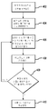
도 4는 본 발명의 원리들에 따라 이동 유닛의 위치를 결정하기 위한 예시적인 방법의 흐름도를 도시하는 도면.
도 5는 복수의 장소(site)들을 통해 집합된 몬테 카를로(Monte Carlo) 시뮬레이션을 이용하는 성능 개선을 요약하여 도시한 도면.
도 6은 개선된 칼만 필터 스티치 방법의 더 상세한 내용을 도시하는 도면.
도 7은 세션이 16초의 타임아웃을 가지는 가상(hypothetical) 상황을 예시하는 도면.
도 8은 단지 2개의 위성들만 획득된 후, 3개의 상이한 위성 측정들을 가지기 이전에 개선된 시드 위치가 획득될 수 있는 가상 상황을 예시하는 도면.
도 9는 세션 시작 후 GPS 시간이 약 20초까지 획득되지 못하는 가상 경우를 도시하는 도면.1 illustrates a general conceptual diagram of a mobile device in communication with a cellular phone network and a satellite based positioning system.
2 illustrates portions of a mobile communication device in accordance with the principles of the present invention.
3 shows a timeline of an exemplary method for determining the position of a mobile unit, in accordance with the principles of the present invention.
4 shows a flowchart of an exemplary method for determining a position of a mobile unit in accordance with the principles of the invention.
FIG. 5 summarizes performance improvements using Monte Carlo simulations aggregated across a plurality of sites. FIG.
6 shows more details of the improved Kalman filter stitch method.
7 illustrates a hypothetical situation in which a session has a timeout of 16 seconds.
FIG. 8 illustrates a hypothetical situation in which an improved seed position may be obtained after only two satellites have been acquired and before having three different satellite measurements.
9 illustrates a hypothetical case in which GPS time is not obtained until about 20 seconds after the start of a session.
첨부되는 도면과 관련하여 아래에서 설명되는 상세한 설명은 본 발명의 다양한 실시예들의 설명으로서 의도되며, 본 발명이 구현될 수 있는 유일한 실시예들을 나타내는 것으로 의도되지 않는다. 본 출원에서 설명되는 각 실시예는 단순히 본 발명의 예 혹은 예시로서 제공되며, 다른 실시예들보다 바람직하거나 우월한 것으로서 반드시 해석되지는 않아야 한다. 상세한 설명은 본 발명의 완전한 이해를 제공하기 위한 목적으로 특정 상세항목을 포함한다. 그러나, 본 발명이 속한 기술 분야에서 통상의 지식을 가진 자에게는 본 발명이 이들 측정 상세항목들 없이도 실시될 수 있다는 점이 명백할 것이다. 몇몇 경우들에서, 본 발명의 개념들을 모호하게 하는 것을 회피하기 위해 잘 알려진 구조들 및 디바이스들이 블록도의 형태로 도시된다. 약어들 및 다른 설명적인 용어들은 단지 편의성 및 명료성을 위해 사용될 수 있으며, 본 발명의 범위를 제한하는 것으로 의도되지 않는다. 더욱이, 본 발명의 목적들을 위해, 상기 용어 "결합된"은 " 연결된"을 의미하며, 이러한 연결은, 직접적이거나, 혹은 상황에 적합한 경우, 예를 들어 중재 혹은 중간 디바이스들 혹은 다른 디바이스들을 통해 간접적일 수 있다.The detailed description set forth below in connection with the appended drawings is intended as a description of various embodiments of the invention and is not intended to represent the only embodiments in which the invention may be implemented. Each embodiment described in this application is provided merely as an example or illustration of the present invention and should not necessarily be construed as preferred or superior to other embodiments. The detailed description includes specific details for the purpose of providing a thorough understanding of the present invention. However, it will be apparent to one of ordinary skill in the art that the present invention may be practiced without these measurement details. In some instances, well known structures and devices are shown in block diagram form in order to avoid obscuring the concepts of the present invention. Abbreviations and other descriptive terms may be used only for convenience and clarity, and are not intended to limit the scope of the invention. Moreover, for the purposes of the present invention, the term "coupled" means "connected", which connection is direct or, where appropriate, indirectly, for example through mediation or intermediate devices or other devices. Can be.
도 1에 도시된 바와 같이, 이동 유닛(104)은 위치 솔루션을 계산하기 위해, 위성 이동체들(106) 및/또는 기지국들(108)과 같은 참조 스테이션들로부터 네비게이션 신호들(예를 들어, 위성 네비게이션 신호들(110) 혹은 무선 통신 신호들(112))을 수신할 수 있는 다양한 이동 수신기들 중 임의의 하나의 형태를 취할 수 있다. 예들로는, 이동 전화, 핸드헬드 네비게이션 수신기, 비행기, 오토바이, 트럭, 탱크, 선박 등과 같은 차량 내에 장착된 수신기를 포함한다. 기지국들(108)은 다수의 무선 통신 프로토콜들 중 하나에 따라 이동 유닛(104)과 통신할 수 있다. 하나의 일반적인 무선 통신 프로토콜은, 복수의 통신들이 무선 주파수(RF) 스펙트럼을 통해 동시에 접속되는 코드 분할 다중화 접속(CDMA)이다. CDMA 환경에서, 상기 기술들은 개선된 어드밴스드 순방향 링크 삼각 측량을 위한 메커니즘으로 보여질 수 있다. 다른 예들은 데이터를 전송하기 위해 협대역 시분할 다중 접속(TDMA)을 이용하는 이동 통신용 글로벌 시스템(GSM) 및 범용 패킷 무선 서비스(General Packet Radio Service(GPRS))를 포함한다. 몇몇 실시예들에서, 이동 유닛(104)은 음성 혹은 데이터 통신을 위해 GPS 수신기 및 무선 통신 디바이스 모두를 일체화할 수 있다. 따라서, GPS 시스템의 특정 예가 본 명세서 내에 설명될 수 있지만, 본 발명의 원리들 및 기술들은 임의의 위성 위치지정 시스템 혹은 무선 네트워크와 같은 지상 위치지정 시스템에 적용가능하다.As shown in FIG. 1, the
이동 유닛(104)은 위성들(106) 및 기지국들(108)로부터 개별적으로 수신된 신호들(110,112)에 기반하여 위치지정 솔루션을 계산하는 기술들을 적용한다. 이동 유닛(104)은 관측되는 위성들(106)로부터 신호들(110)을 획득하고, 의사거리 측정을 결정하기 위해 상기 개별적인 위성으로부터 이동 유닛(104)으로 이동하는 각 신호에 대해 획득된 시간을 측정함으로써 각 위성으로부터의 거리를 측정한다. 유사하게, 이동 유닛(104)은 또한, 무선 통신 시스템(107)의 기지국들(108)로부터 신호들(112)을 수신할 수 있고, 상기 기지국들로부터 상기 이동 유닛으로 이동하는 각 무선 신호에 대해 획득된 시간에 기반하여 기지국들(108)로부터의 거리를 측정한다. 이동 유닛(104)은 통상적으로 상기 측정들에 기반하여 위치 및 시간 변수들을 결정한다.
도 2는 본 발명의 원리들에 따라, 상기 이동 유닛(104)에 대한 위치 결정과 관련한 이동 통신 디바이스(104)의 일부에 대한 블록도를 도시한다. 상기 이동 유닛(104)은 위성 네비게이션 시스템 혹은 위성 위치지정 시스템으로부터 신호들을 수신하도록 구성된 안테나(220) 및 지상 통신 네트워크로부터 신호들을 수신하도록 구성된 또다른 안테나(206)를 포함할 수 있다. 이들 신호들은, 상기 신호들에 대해 신호 처리 기능을 제공하기 위해 소프트웨어 및 하드웨어 컴포넌트들 둘 다를 포함하는 프로세서(202)에 제공된다. 특정하게, 상기 이동 유닛(104) 위치 결정 기능들을 보조하기 위해 상기 이동 유닛(104)의 일 부분으로서 칼만 필터(204)가 구현된다.2 shows a block diagram of a portion of a
당해 기술분야에 잘 알려진 바와 같이, 칼만 필터(204)와 같은 위치지정 필터는 입력 측정들을 수신하고, 상기 입력 측정들 및 시스템의 히스토리 상태에 기반하여 요구되는 변수들을 측정하기 위한 알고리즘을 구현한다. 도시되지는 않았지만, 메모리는, 칼만 필터에 의해 제공되는 상태 추정들의 에러의 정도 혹은 확실성의 정도를 제공하는 상기 칼만 필터에 대한 공분산 매트릭스 값들 및 상태 정보를 저장하는데 종종 사용된다.As is well known in the art, a positional filter such as
상기 이동 유닛(104)은 예를 들어, 셀룰러 폰 혹은 유사한 셀룰러 통신 디바이스일 수 있다. 따라서, 도 2에 도시되지 않은 상기 이동 유닛(104)의 일부분들인 부가적인 기능 블록들 및 디바이스들이 존재한다. 이들 부가적인 블록들 및/또는 디바이스들은 상기 안테나들(206,220)로부터 수신된 신호들을 처리하는 것; 사용자 인터페이스를 제공하는 것, 스피치 통신들을 제공하는 것, 데이터 통신들을 제공하는 것, 및 다른 성능들과 통상적으로 관련한다. 이들 기능 블록들 및 디바이스들 중 많은 것들이 위치 결정에 직접적으로 관련되지는 않으며, 따라서, 본 발명의 원리들을 모호하게 하지 않기 위해 포함되지 않는다.The
앞서 간단히 설명된 바와 같이, 신호들은 통상적으로 안테나(220)에 의해 위성 이동체들로부터 수신된다. 이후 이들 신호들이 디코딩되고 잘 알려진 알고리즘들 및 기술들을 사용하여 위치 정보로 처리된다. 과거에는, 칼만 필터(204)를 초기화하는데 이용될 수 있는 가중치 부여 최소 제곱(WLS) 모델을 사용하여 위치 픽스(fix)를 생성하기 위해, 적어도 3개의 위성 이동체들로부터의 신호들이 단일 측정 에포크동안 요구되었다. 일단 상기 칼만 필터가 초기화되면, 추후 이루어지는 GPS 측정들에 기반하여 위치 추정들을 계속 생성할 수 있다. 도 3은 (1,2, 혹은 3개의 위성들로부터의) GPS 측정들(302)이 개별 측정 에포크들(300)동안 수신되고, 최초의 측정들중 어느 것도 3개의 상이한 위성 이동체로부터의 동시적인 신호들을 포함하지 않는 시나리오를 도시한다. 따라서, 위치 정보를 포함하는 신호들이 계속해서 획득하더라도 과거의 칼만 필터는 GPS 측정들이 (시간(306)에서 발생하는) 단일 측정 에포크 동안 3개의 상이한 위성들로부터 획득될 때가지 초기화 될 수 없었다.As briefly described above, signals are typically received from satellite mobiles by
반면, 본 발명의 실시예들은 칼만 필터를 초기화하기 위해 상이한 측정 에포크동안 획득되는 위치픽스 정보를 사용한다. 따라서, 복수의, 비-동시적인 측정 에포크들로부터의 3개의 상이한 측정들은 (시간 (306)보다 훨씬 이른) 시간(304)에서 사용가능하며, 칼만 필터는 이러한 더 이른 포인트에서 우수한 품질의 픽스를 제공할 수 있다. 이전 설명은 단지 3개의 위성 측정 신호들만이 수신기의 위치 픽스를 생성하는데 필요하다는 가정에 의존했다. 상기 가정은 고도 정보가 통신 네트워크등과 같은 대체 소스들로부터 사용가능하다는 점에 기초한다. 대안적으로, 만약 어떠한 고도 정보도 사용가능하지 않다면, 동일한 원리가 3개 대신 4개의 위성들에 적용된다.In contrast, embodiments of the present invention use position fix information obtained during different measurement epochs to initialize the Kalman filter. Thus, three different measurements from a plurality of non-simultaneous measurement epochs are available at time 304 (much earlier than time 306), and the Kalman filter provides a good quality fix at this earlier point. Can provide. The previous description relies on the assumption that only three satellite measurement signals are needed to generate the position fix of the receiver. The assumption is based on the fact that altitude information is available from alternative sources such as communication networks and the like. Alternatively, if no altitude information is available, the same principle applies to four satellites instead of three.
3개의 위치 지정 측정들이 사용가능하기 전이라 할지라도, 본 발명의 실시예들은 초기 위치에 대해 현저하게 개선하도록 2개의 측정들을 사용할 수 있다. 예를 들어, 2개의 위성으로부터의 측정들을 사용하는 것은, 통상적으로 초기 위치보다 적어도 30% 이상 정확한, 종종 100 - 500 미터 내에 드는 수평 위치 추정을 제공할 수 있다.Even before three positioning measurements are available, embodiments of the present invention may use two measurements to significantly improve the initial position. For example, using measurements from two satellites can provide a horizontal position estimate that often falls within 100-500 meters, typically at least 30% more accurate than the initial position.
도 4는 본 발명의 원리들에 따라, 위치 정보를 제공하기 위해 상이한 위성 측정들을 사용하는 예시적인 방법의 흐름도를 도시한다. 단계(402)에서, 이동 유닛은 통신 네트워크 혹은 메모리로부터 사용가능한 임의의 어시스턴스(assistance) 정보를 획득함으로써 시작한다. 예를 들어, 50미터 이내의 고도는, 어시스트된- GPS 시스템이 현재 존재하는 경우 수백 미터내에 위치될 수 있기에 사용가능할 수 있다. 다음으로, 단계 404에서, 이러한 정보는 칼만 필터 상태 및 공분산 매트릭스를 시드하는데 사용된다. 상기 칼만 필터는 위치 예측을 제공하고, 또한 현재 위치 및 속도를 제공하기 위해 이전 예측을 수정하도록 설계된다. 따라서, 상기 통신 네트워크, 디바이스 메모리, 혹은 다른 소스들이 상기 칼만 필터를 시딩하는 에러 추정들 및 초기 위치를 제공할 수 있다. 4 shows a flowchart of an exemplary method of using different satellite measurements to provide location information, in accordance with the principles of the present invention. In
다음으로, 단계 406에서, 칼만 필터 상태 및 공분산 메트릭스는 임의의 위성 이동체로부터 획득된 임의의 위치 정보를 사용하여 업데이트된다. 예를 들어, 만약 지구의 비교적 작은 부분(예를 들어 무선 네트워크 셀 섹터) 내에 있는 상기 이동 유닛의 위치가 알려져 있는 경우, 2개의 위성으로부터의 의사거리 정보가 상기 이동 유닛이 위치되는 비교적 짧은 직선 라인 세그먼트를 식별하기 위해 사용될 수 있다. 상기 칼만 필터의 고유한 동작의 일부분으로서, 공분산 매트릭스들은 예측된 값들에 대한 새로운 에러 추정을 반영하도록 자동으로 업데이트된다. 따라서, 칼만 필터는, 예를 들어, 단계 408에서, 상기 에러 또는 불확실성의 추정과 함께 상기 이동 유닛의 위도 및 경도의 추정을 제공한다. 상기 이동 유닛의 고도 역시 상기 칼만 필터에 의해 제공된다. 단계 409는 상기 추정된 에러들이 상기 어플리케이션 요건을 충족하는지의 여부를 결정하기 위한 테스트를 제공한다. 만약 그러하다면(yes), 단계 410으로 진행하여, 상기 어플리케이션으로 상기 추정된 위도, 경도 및 고도를 제공한다. 만약 아니라면(no), 단계 406으로 되돌아간다. 본 발명이 속한 분야에서 통상의 지식을 가진 자라면 상기 상태 및 공분산 매트릭스들에서 로딩되고 업데이트된 정보가 적절한 포맷임을 보장하도록 다양한 수학적 처리 및 좌표 변환들이 수행될 수 있다는 점을 인지할 것이다.Next, at
도 5는 복수의 사이트들에 걸쳐 종합된 몬테 카를로 시뮬레이션을 사용하는 성능 개선을 요약한다. 68 퍼센트에 대한 수평 에러(HE)는 WLS에 대해 333m로부터 KF스티치에 대해 124m로 개선된다. 95퍼센트에 대한 HE는 WLS에 대해 942m로부터 KF 스티치에 대해 838m로 개선된다. 5 summarizes performance improvements using Monte Carlo simulations aggregated across multiple sites. The horizontal error (HE) for 68 percent is improved from 333 m for WLS to 124 m for KF stitches. HE for 95 percent improves from 942 m for WLS to 838 m for KF stitches.
도 3으로 잠시 돌아가면, 후속적인 에포크들로부터의 GPS 측정들은 다른 위성들로부터의 데이터가 사용가능하지 않는 경우라 할지라도 (칼만 필터를 통해) 상기 추정을 정제(refine)하는데 사용될 수 있다. 따라서, 예를 들어, 위성 이동체"1"로부터의 두 개의 인접한 측정들은, 또다른 위성 이동체로부터의 어떠한 정보도 사용가능하지 않는다 할지라도 상기 칼만 필터에 의해 사용될 수 있다. 결국, 추가적인 위성들로부터의 정보가 획득되는 경우, 이러한 측정들이 상기 동일한 측정 에포크동안 수신되지 않는다 할지라도, 상기 칼만 필터로부터의 추정이 그에 따라 업데이트될 수 있다. 궁극적으로, 충분한 업데이트들 후에, 상기 칼만 필터는 어플리케이션-수용가능한 불확실성 레벨 내에서 위치 및 속도를 예측할 수 있을 것이다.Turning back to FIG. 3, GPS measurements from subsequent epochs can be used to refine the estimate (via Kalman filter) even if data from other satellites is not available. Thus, for example, two adjacent measurements from satellite mover " 1 " can be used by the Kalman filter even if no information from another satellite mover is available. As a result, if information from additional satellites is obtained, even if these measurements are not received during the same measurement epoch, the estimate from the Kalman filter can be updated accordingly. Ultimately, after sufficient updates, the Kalman filter will be able to predict position and velocity within an application-acceptable level of uncertainty.
상기 개선된 칼만 필터 스티치 방법의 추가적인 상세 내용(elaboration)이 도 6에 도시된다. 상부(top) 다이어그램은 적어도 3개의 동시적인 GPS 측정들이 사용가능해질 때까지 상기 칼만 필터가 초기화될 수 없는 이동 수신기에 대한 종래의 GPS 측정 타임라인 시나리오를 예시한다. KF 추정 프로세스를 시작하기 위해 3개 위성을 이용하는 WLS 위치 픽스가 필요하고, 본 가상 예에서 이는 세션이 시작한지 거의 30초 후에 발생한다. 후속적으로, 상기 KF는 주어지 에포크에서 사용가능한 3개 미만의 위치 측정들을 사용하여 위치 픽스들을 계속 업데이트한다. 반면, 하부(bottom) 다이어그램은 상기 칼만 필터가 본 발명의 "스티칭(stitching)" 성능들을 사용하여 3개의 비-동시적인 GPS 측정들을 사용하여 전형적-GPS-품질 위치 솔루션을 생성하는 본 발명의 GPS 측정 타임라인을 도시한다. 이 경우, 상기 KF 추정 프로세스는, 적어도 3개의 위성들이 비록 상이한 에포크들에서지만 성공적으로 관측되는 경우, 상기 세션이 시작한지 대략 10초 후에 시작한다. 더욱이, 이러한 성공적인 초기화 후, 상기 KF는, 심지어 주어진 에포크에서 사용가능한 3개 미만의 위성 측정들을 사용하여 위치 픽스들을 계속 업데이트한다.Further elaboration of the improved Kalman filter stitch method is shown in FIG. 6. The top diagram illustrates a conventional GPS measurement timeline scenario for a mobile receiver in which the Kalman filter cannot be initialized until at least three simultaneous GPS measurements are available. A WLS location fix using three satellites is needed to begin the KF estimation process, which in this hypothetical example occurs almost 30 seconds after the session started. Subsequently, the KF continues to update the position fixes using less than three position measurements available at a given epoch. On the other hand, the bottom diagram shows that the Kalman filter uses the present invention's "stitching" capabilities to create a typical-GPS-quality location solution using three non-simultaneous GPS measurements. Show the measurement timeline. In this case, the KF estimation process begins approximately 10 seconds after the session starts if at least three satellites are successfully observed, but only at different epochs. Moreover, after this successful initialization, the KF continues to update the location fixes even with less than three satellite measurements available at a given epoch.
따라서, 위에서 예시된 상기 개선된 KF 스티치 방법은 불리한 신호 환경들에서 이동 GPS 수신기들에 대한 제 1 픽스를 위해 필요한 시간을 매우 감소시킬 수 있다. 또한, 더 앞서 논의된 바와 같이, 개선된 수평 위치지정 정확성 역시 유지될 수 있다.Thus, the improved KF stitch method illustrated above can greatly reduce the time required for the first fix for mobile GPS receivers in adverse signal environments. In addition, as discussed earlier, improved horizontal positioning accuracy may also be maintained.
본 발명의 또다른 이점은 험난한 신호 환경에서의 개선된 솔루션을 제공한다. 예를 들어, 도 7은 16초의 가상 세션 타임아웃을 부가하는 도 6에서와 동일한 가상 예를 도시한다. WLS 추정에 기반하는 종래의 위치 픽스는 거의 30초의 지연으로 인해 상기 타임아웃 픽스 이전에 유효한 위치를 획득하지 않을 것이다. 반면, 본 발명의 상기 KF 스티치에 기반하는 초기 위치 픽스는 타임아웃 한계 미만에서 유효한 픽스를 획득할 수 있다. 따라서, 본 발명의 이러한 방법은 어려운 신호 환경들에 있는 이동 GPS 수신기들을 위한 훨씬 큰 성공적인 위치 고정 확률을 획득할 수 있다. Another advantage of the present invention provides an improved solution in a harsh signal environment. For example, FIG. 7 shows the same virtual example as in FIG. 6 adding a 16 second virtual session timeout. Conventional location fixes based on WLS estimation will not obtain a valid location before the timeout fix due to a delay of nearly 30 seconds. On the other hand, an initial position fix based on the KF stitch of the present invention may obtain a valid fix below a timeout limit. Thus, this method of the present invention can obtain a much larger successful position fix probability for mobile GPS receivers in difficult signal environments.
본 발명의 또다른 양상은 2-GPS 라인-오브-포지션(2-GPS line-of-position)을 사용하는 시드 위치 불확실성에서의 개선이다. 도 8은 단 2개의 위성들이 획득되는 가상 상황을 예시하며, 개선된 시드 위치는 3개의 상이한 위성 측정들을 가지기에 앞서 획득될 수 있다. 이러한 특징은 3차원 위치지정에 있어서, 2개의 유효 의사거리 측정들 더하기 고도를 가지는 것이 1차원의 라인 오브 포지션 솔루션을 야기하는 지오메트릭 특성에 기반한다. 이러한 해법은 완전한 위치 픽스에 비해 단지 하나의 잔여 자유도만을 가지며, 이로 인해 시드 위치에 비해 선형 불확실성이 감소되고, 영역 불확실성이 실질적으로 감소된다. Another aspect of the invention is an improvement in seed position uncertainty using 2-GPS line-of-position. 8 illustrates a hypothetical situation where only two satellites are obtained, and an improved seed position may be obtained prior to having three different satellite measurements. This feature is based on the geometrical properties that, in three-dimensional positioning, having two effective pseudorange measurements plus altitude results in a one-dimensional line of position solution. This solution has only one residual degree over the full position fix, which reduces linear uncertainty and substantially reduces region uncertainty compared to the seed position.
본 발명의 이점들 중 다른 한 예는, 정확한 GPS 시간이 세션 시작시 사용가능하지 않는 경우, 정확한(서브 밀리초) GPS 시간이 획득된 후, 전에 저장된 측정들을 사용하기 위해 역 전파를 사용할 수 있다는 점이다. 예를 들어, 도 9는 GPS 시간이 세션 시작 이후 약 20초까지 획득되지 않는 가상 경우를 도시한다. 다시 말해, GPS 레인징 측정들의 제 1 세트가 획득되고 저장될 수 있지만, GPS 시간 정보의 부족으로 인해 즉시 사용될 수는 없다. GPS 시간이 결정되면, 로컬 클럭 시간과 GPS 시간 간의 관계가 설정되고, 그 다음, 이전에 저장된 GPS 측정들은 올바른 GPS 시간과 연관될 수 있으며, 역 전파 처리는 개선된 위치 결정을 위해 이전에 저장된 데이터를 복원하도록 사용될 수 있다. 따라서, 역 전파는 상기 GPS 수신기로 하여금, GPS 시간이 즉시 획득되지 않는다 할지라도, 모든 유효한 GPS 위성 측정들을 모두 사용하여, 개선된 수율과 정확성을 야기하도록 한다. Another example of the advantages of the present invention is that if the exact GPS time is not available at the beginning of the session, after the exact (sub millisecond) GPS time has been obtained, the backpropagation may be used to use previously stored measurements. Is the point. For example, FIG. 9 illustrates a hypothetical case where GPS time is not obtained until about 20 seconds after the start of the session. In other words, a first set of GPS ranging measurements can be obtained and stored, but cannot be used immediately due to lack of GPS time information. Once the GPS time is determined, a relationship between the local clock time and the GPS time is established, and then previously stored GPS measurements can be associated with the correct GPS time, and the backpropagation process previously stored data for improved positioning. It can be used to restore. Thus, back propagation causes the GPS receiver to use all of the valid GPS satellite measurements, even if GPS time is not obtained immediately, resulting in improved yield and accuracy.
본 발명의 이점들 중 또다른 예는, 정확한 위성 천문 데이터가 세션 시작시 사용가능하지 않는 경우, 정확한 천문 데이터가 획득된 후, 이전에 저장된 측정들을 사용하도록 역 전파를 사용할 수 있다는 점이다. 천문 데이터가 획득되면, 상기 위성 위치가 알려지고, 그 다음, 이전에 저장된 GPS 측정들이 올바른 위성 천문 데이터와 연관될 수 있으며, 역 전파 처리가 개선된 위치 결정을 위해 이전에 저장된 데이터를 복원하는데 사용될 수 있다. 따라서, 역 전파는 상기 GPS 수신기로 하여금, 위성 천문 데이터가 즉시 획득되지 않는다 할지라도, 모든 유효한 GPS 위성 특징들을 모두 사용하여, 개선된 수율 및 정확도를 초래하는 것을 허용한다.Another example of the advantages of the present invention is that if accurate satellite astronomical data is not available at the beginning of a session, after the correct astronomical data is obtained, it may use back propagation to use previously stored measurements. Once astronomical data is obtained, the satellite position is known, and then previously stored GPS measurements can be associated with the correct satellite astronomical data, and back propagation processing can be used to restore the previously stored data for improved positioning. Can be. Thus, back propagation allows the GPS receiver to use all of the valid GPS satellite features, resulting in improved yield and accuracy, even if satellite astronomical data is not obtained immediately.
실제로, 칼만 필터의 위치 정보가 상기이동 유닛에서 실행중일 수 있는 하나 이상의 어플리케이션들로 제공된다(단계 410). 예를 들어, 지역 날씨(localized weather)와 같은 로케이션 기반 서비스들은 1킬로미터 이상에 근접하는 불확실성을 가지는 위치 추정들을 사용할 수 있다. 반면 "911"서비스들은 50 미터 이하에 근접하는 위치 추정의 불확실성을 요구할 수 있다. 따라서, 상기 위치( 및 속도) 추정들 모두 임의의 불확실성, 혹은 에러 추정들에 따라 어플리케이션에 제공될 수 있다. 이러한 방식으로, 각 어플리케이션은 상기 칼만 필터로부터의 위치 추정이 요건에 충분한지의 여부를 선택할 수 있다.Indeed, positional information of the Kalman filter is provided to one or more applications that may be running in the mobile unit (step 410). For example, location based services, such as localized weather, may use location estimates with uncertainty approaching more than one kilometer. "911" services, on the other hand, may require uncertainty in location estimates approaching 50 meters or less. Thus, all of the position (and velocity) estimates may be provided to the application according to any uncertainty or error estimates. In this way, each application can select whether the position estimate from the Kalman filter is sufficient for the requirements.
무선을 통한 다양한 타입들의 브로드캐스팅을 위해 본 명세서에 설명된 기술들은 다양한 수단들에 의해 구현될 수 있다. 예를 들어, 이들 기술들은 하드웨어, 소프트웨어 및 이들의 결합으로 구현될 수 있다. 하드웨어 구현에 있어서, 상이한 타입들의 전송을 브로드캐스트하는데 사용되는 기지국에 있는 상기 처리 유닛들은 하나 이상의 주문형 반도체(ASIC)들, 디지털 신호 처리기들(DSP), 디지털 신호 처리 디바이스들(DSPD), 프로그래머블 로직 디바이스들(PLD), 필드 프로그래머블 게이트 어레이들(FPGA), 프로세서들, 처리기들, 마이크로처리기들, 마이크로 프로세서들, 본 명세서에 설명된 기능들을 수행하도록 설계된 다른 전자 유닛들 혹은 이들의 결합 내에서 구현될 수 있다. 상이한 타입들의 전송을 수신하기 위해 사용된 무선 디바이스에 있는 처리 유닛들은 또한 하나 이상의 ASIC들, DPS들 등 내에서 구현될 수 있다.The techniques described herein for various types of broadcasting over wireless may be implemented by various means. For example, these techniques can be implemented in hardware, software, and combinations thereof. In a hardware implementation, the processing units at the base station used to broadcast different types of transmissions may include one or more application specific semiconductors (ASICs), digital signal processors (DSPs), digital signal processing devices (DSPDs), programmable logic. Implements in devices PLD, field programmable gate arrays (FPGA), processors, processors, microprocessors, microprocessors, other electronic units designed to perform the functions described herein, or a combination thereof Can be. Processing units in a wireless device used to receive different types of transmissions may also be implemented within one or more ASICs, DPSs, and the like.
소프트웨어 구현에 대해, 본 명세서에서 설명된 기술들은 본 명세서에 설명된 기능들을 수행하는 모듈들(예를 들어, 프로시저들, 기능들 등)로써 구현될 수 있다. 상기 소프트에어 코드들은 메모리에 저장되고 프로세서에 의해 실행될 수 있다. 상기 메모리 유닛은, 프로세서내에서 혹은 상기 프로세서의 외부에서 구현될 수 있으며, 어느 경우에서건, 당해 분야에 알려진 다양한 수단을 통해 상기 프로세서에 결합하여 통신할 수 있다. For software implementation, the techniques described herein may be implemented as modules (eg, procedures, functions, etc.) that perform the functions described herein. The software codes may be stored in a memory and executed by a processor. The memory unit may be implemented within the processor or external to the processor, and in either case may be coupled to and communicate with the processor via various means known in the art.
이전 설명은 본 발명이 속한 기술분야에서 통상의 지식을 가진 자가 본 명세서에 설명된 다양한 실시예들을 구현할 수 있도록 제공된다. 이들 실시예들의 다양한 수정은 본 발명이 속한 기술분야에서 통상의 지식을 가진 자에게는 즉시 명백할 것이며, 본 명세서에서 정의된 일반 원리들은 다른 실시예들에 적용될 수 있다. 따라서, 청구항들은 본 명세서에서 보여진 상기 실시예들에 제한되는 것으로 의도되지 않고, 청구항 용어와 일치하는 전체 범위에 따르며, 엘리먼트에 대한 단수의 특정하게 언급되지 않는 이상 "하나만"을 의미하는 것이 아니라 "하나 이상"을 의미하는 것으로 의도된다. 본 발명이 속한 기술 분야에서 통상의 지식을 가지 자에게 알려졌거나 추후 알려지게 될 본 명세서 전체에 걸쳐 설명된 상기 다양한 실시예의 모든 구조적인 그리고 기능적인 등가물은 본 명세서에 참조로 명시적으로 포함되며, 청구항들에 의해 포함되는 것으로 의도된다. 더욱이, 본 발명이 청구항에서 명시적으로 인용되었는지의 여부와는 무관하게, 본 발명에 개시된 어떠한 것도, 공중에 전용되도록 의도되지 않는다. 35 U.S.C.§112 조항 6번째 문단 하에서, 엘리먼트가 상기 구문 "~를 위한 수단"을 사용하여 명시적으로 인용되지 않는 이상, 방법 청구항인 경우, 상기 엘리먼트가 구문 "~하기 위한 단계"를 사용하여 인용되지 않는 이상, 어떠한 청구항 엘리먼트도 해석되지 않아야 한다.
The previous description is provided to enable any person skilled in the art to practice the various embodiments described herein. Various modifications to these embodiments will be readily apparent to those skilled in the art, and the generic principles defined herein may be applied to other embodiments. Accordingly, the claims are not intended to be limited to the embodiments shown herein and are to be accorded the full scope consistent with the terms of the claims, and do not mean "one only" unless specifically stated in the singular to the element ". One or more ". All structural and functional equivalents of the various embodiments described throughout this specification, which will be known to one of ordinary skill in the art or will be known later, are expressly incorporated herein by reference, It is intended to be covered by the claims. Moreover, nothing disclosed herein is intended to be dedicated to the public regardless of whether the invention is expressly recited in the claims. 35 Under USC§112 clause 6, if an element is a method claim, unless the element is expressly recited using the phrase "means for," the element is quoted using the phrase "step to do". Unless otherwise stated, no claim element should be construed.
Claims (18)
로컬 클럭 시간으로 타임스탬핑된, 하나 이상의 전송기로부터 획득된 측정 정보를 저장하는 단계;
위성 이동체(SV: satellite vehicle) 시스템 시간이 획득되는 경우, 상기 로컬 클럭 시간 및 상기 위성 이동체 시스템 시간 간의 시간 관계를 설정하는 단계;
상기 로컬 클럭 시간 및 상기 위성 이동체 시스템 시간 간의 상기 시간 관계에 기반하여 상기 저장된 측정 정보의 상기 위성 이동체 시스템 시간을 결정하는 단계; 및
상기 이동 통신 디바이스의 상기 위치를 결정하기 위해 상기 저장된 측정 정보, 및 상기 저장된 측정 정보의 상기 위성 이동체 시스템 시간을 사용하는 단계를 포함하는,
이동 통신 디바이스의 위치를 추정하기 위한 방법.A method for estimating a location of a mobile communication device, performed by a mobile communication device,
Storing measurement information obtained from one or more transmitters, time stamped with a local clock time;
When a satellite vehicle (SV) system time is obtained, establishing a time relationship between the local clock time and the satellite vehicle system time;
Determining the satellite mobile system time of the stored measurement information based on the time relationship between the local clock time and the satellite mobile system time; And
Using the stored measurement information and the satellite mobile system time of the stored measurement information to determine the location of the mobile communication device,
A method for estimating a location of a mobile communication device.
천체 위치 정보(ephemeris information) 없이 하나 이상의 전송기로부터 획득된 측정 정보를 저장하는 단계;
상기 하나 이상의 전송기에 대한 천체 위치 정보를 결정하는 단계; 및
상기 이동 통신 디바이스의 위치를 결정하기 위해, 상기 결정된 천체 위치 정보를 사용하여 상기 저장된 측정 정보를 복원하는 단계를 포함하는,
이동 통신 디바이스의 위치를 추정하기 위한 방법.A method for estimating a location of a mobile communication device, performed by a mobile communication device,
Storing measurement information obtained from one or more transmitters without ephemeris information;
Determining celestial position information for the one or more transmitters; And
Recovering the stored measurement information using the determined celestial position information to determine a location of the mobile communication device,
A method for estimating a location of a mobile communication device.
상기 하나 이상의 전송기는 위성 이동체들에 위치하는, 이동 통신 디바이스의 위치를 추정하기 위한 방법.The method of claim 1,
And wherein the one or more transmitters are located in satellite mobiles.
상기 하나 이상의 전송기는 기지국들에 위치하는, 이동 통신 디바이스의 위치를 추정하기 위한 방법.The method of claim 1,
And wherein the one or more transmitters are located in base stations.
상기 하나 이상의 전송기는 위성 이동체들에 위치하는, 이동 통신 디바이스의 위치를 추정하기 위한 방법.The method of claim 2,
And wherein the one or more transmitters are located in satellite mobiles.
상기 하나 이상의 전송기는 기지국들에 위치하는, 이동 통신 디바이스의 위치를 추정하기 위한 방법.The method of claim 2,
And wherein the one or more transmitters are located in base stations.
로컬 클럭 시간으로 타임스탬핑된, 하나 이상의 전송기로부터 획득된 측정 정보를 저장하기 위한 수단;
위성 이동체(SV: satellite vehicle) 시스템 시간이 획득되는 경우, 상기 로컬 클럭 시간 및 상기 위성 이동체 시스템 시간 간의 시간 관계를 설정하기 위한 수단;
상기 로컬 클럭 시간 및 상기 위성 이동체 시스템 시간 간의 상기 시간 관계에 기반하여 상기 저장된 측정 정보의 상기 위성 이동체 시스템 시간을 결정하기 위한 수단; 및
상기 이동 통신 디바이스의 상기 위치를 결정하기 위해 상기 저장된 측정 정보, 및 상기 저장된 측정 정보의 상기 위성 이동체 시스템 시간을 사용하기 위한 수단을 포함하는,
이동 통신 디바이스의 위치를 추정하기 위한 장치.An apparatus for estimating a location of a mobile communication device,
Means for storing measurement information obtained from one or more transmitters, time stamped with a local clock time;
Means for establishing a time relationship between the local clock time and the satellite vehicle system time when a satellite vehicle (SV) system time is obtained;
Means for determining the satellite mobile system time of the stored measurement information based on the time relationship between the local clock time and the satellite mobile system time; And
Means for using the stored measurement information and the satellite mobile system time of the stored measurement information to determine the location of the mobile communication device;
An apparatus for estimating a location of a mobile communication device.
천체 위치 정보(ephemeris information) 없이 하나 이상의 전송기로부터 획득된 측정 정보를 저장하기 위한 수단;
상기 하나 이상의 전송기에 대한 천체 위치 정보를 결정하기 위한 수단; 및
상기 이동 통신 디바이스의 위치를 결정하기 위해, 상기 결정된 천체 위치 정보를 사용하여 상기 저장된 측정 정보를 복원하기 위한 수단을 포함하는,
이동 통신 디바이스의 위치를 추정하기 위한 장치.An apparatus for estimating a location of a mobile communication device,
Means for storing measurement information obtained from one or more transmitters without ephemeris information;
Means for determining celestial position information for the one or more transmitters; And
Means for recovering the stored measurement information using the determined celestial position information to determine a location of the mobile communication device,
An apparatus for estimating a location of a mobile communication device.
상기 하나 이상의 전송기는 위성 이동체들에 위치하는, 이동 통신 디바이스의 위치를 추정하기 위한 장치.The method of claim 7, wherein
And the one or more transmitters are located in satellite mobiles.
상기 하나 이상의 전송기는 기지국들에 위치하는, 이동 통신 디바이스의 위치를 추정하기 위한 장치.The method of claim 7, wherein
And the one or more transmitters are located at base stations.
상기 하나 이상의 전송기는 위성 이동체들에 위치하는, 이동 통신 디바이스의 위치를 추정하기 위한 장치.9. The method of claim 8,
And the one or more transmitters are located in satellite mobiles.
상기 하나 이상의 전송기는 기지국들에 위치하는, 이동 통신 디바이스의 위치를 추정하기 위한 장치.9. The method of claim 8,
And the one or more transmitters are located at base stations.
로컬 클럭 시간으로 타임스탬핑된, 하나 이상의 전송기로부터 획득된 측정 정보를 저장하기 위한 명령;
위성 이동체(SV: satellite vehicle) 시스템 시간이 획득되는 경우, 상기 로컬 클럭 시간 및 상기 위성 이동체 시스템 시간 간의 시간 관계를 설정하기 위한 명령;
상기 로컬 클럭 시간 및 상기 위성 이동체 시스템 시간 간의 상기 시간 관계에 기반하여 상기 저장된 측정 정보의 상기 위성 이동체 시스템 시간을 결정하기 위한 명령; 및
상기 이동 통신 디바이스의 상기 위치를 결정하기 위해 상기 저장된 측정 정보, 및 상기 저장된 측정 정보의 상기 위성 이동체 시스템 시간을 사용하기 위한 명령을 포함하는,
컴퓨터 판독가능한 매체.A computer readable medium comprising a set of instructions for causing a computer to perform a method for estimating a location of a mobile communication device, wherein the instructions are
Instructions for storing measurement information obtained from one or more transmitters, time stamped with a local clock time;
Instructions for establishing a time relationship between the local clock time and the satellite vehicle system time when a satellite vehicle (SV) system time is obtained;
Determining the satellite mobile system time of the stored measurement information based on the time relationship between the local clock time and the satellite mobile system time; And
Instructions for using the stored measurement information and the satellite mobile system time of the stored measurement information to determine the location of the mobile communication device,
Computer readable medium.
천체 위치 정보(ephemeris information) 없이 하나 이상의 전송기로부터 획득된 측정 정보를 저장하기 위한 명령;
상기 하나 이상의 전송기에 대한 천체 위치 정보를 결정하기 위한 명령; 및
상기 이동 통신 디바이스의 위치를 결정하기 위해, 상기 결정된 천체 위치 정보를 사용하여 상기 저장된 측정 정보를 복원하기 위한 명령을 포함하는,
컴퓨터 판독가능한 매체.A computer readable medium comprising a set of instructions for causing a computer to perform a method for estimating a location of a mobile communication device, wherein the instructions are
Instructions for storing measurement information obtained from one or more transmitters without ephemeris information;
Instructions for determining celestial position information for the one or more transmitters; And
Instructions for restoring the stored measurement information using the determined celestial position information to determine a location of the mobile communication device,
Computer readable medium.
상기 하나 이상의 전송기는 위성 이동체들에 위치하는, 컴퓨터 판독가능한 매체.The method of claim 13,
And the one or more transmitters are located in satellite mobiles.
상기 하나 이상의 전송기는 기지국들에 위치하는, 컴퓨터 판독가능한 매체.The method of claim 13,
And the one or more transmitters are located at base stations.
상기 하나 이상의 전송기는 위성 이동체들에 위치하는, 컴퓨터 판독가능한 매체.15. The method of claim 14,
And the one or more transmitters are located in satellite mobiles.
상기 하나 이상의 전송기는 기지국들에 위치하는, 컴퓨터 판독가능한 매체.
15. The method of claim 14,
And the one or more transmitters are located at base stations.
Applications Claiming Priority (3)
| Application Number | Priority Date | Filing Date | Title |
|---|---|---|---|
| US77993506P | 2006-03-06 | 2006-03-06 | |
| US60/779,935 | 2006-03-06 | ||
| PCT/US2007/063428 WO2008019172A2 (en) | 2006-03-06 | 2007-03-06 | Method for position determination with measurement stitching |
Related Parent Applications (1)
| Application Number | Title | Priority Date | Filing Date |
|---|---|---|---|
| KR1020087024374A Division KR101042730B1 (en) | 2006-03-06 | 2007-03-06 | Method for position determination with measurement stitching |
Publications (2)
| Publication Number | Publication Date |
|---|---|
| KR20110017018A KR20110017018A (en) | 2011-02-18 |
| KR101216551B1 true KR101216551B1 (en) | 2012-12-31 |
Family
ID=39033535
Family Applications (2)
| Application Number | Title | Priority Date | Filing Date |
|---|---|---|---|
| KR1020117002605A KR101216551B1 (en) | 2006-03-06 | 2007-03-06 | Method for position determination with measurement stitching |
| KR1020087024374A KR101042730B1 (en) | 2006-03-06 | 2007-03-06 | Method for position determination with measurement stitching |
Family Applications After (1)
| Application Number | Title | Priority Date | Filing Date |
|---|---|---|---|
| KR1020087024374A KR101042730B1 (en) | 2006-03-06 | 2007-03-06 | Method for position determination with measurement stitching |
Country Status (9)
| Country | Link |
|---|---|
| US (2) | US9354321B2 (en) |
| EP (2) | EP1991883A2 (en) |
| JP (2) | JP5425478B2 (en) |
| KR (2) | KR101216551B1 (en) |
| CN (2) | CN101395491B (en) |
| BR (1) | BRPI0708496B1 (en) |
| CA (1) | CA2641335C (en) |
| RU (2) | RU2543618C2 (en) |
| WO (1) | WO2008019172A2 (en) |
Families Citing this family (37)
| Publication number | Priority date | Publication date | Assignee | Title |
|---|---|---|---|---|
| KR101216551B1 (en) * | 2006-03-06 | 2012-12-31 | 콸콤 인코포레이티드 | Method for position determination with measurement stitching |
| US20080180315A1 (en) * | 2007-01-26 | 2008-07-31 | Sige Semiconductor (Europe) Limited | Methods and systems for position estimation using satellite signals over multiple receive signal instances |
| US7586441B2 (en) * | 2007-06-27 | 2009-09-08 | Mediatek Inc. | Methods and apparatuses for searching for satellite signals |
| US8368588B2 (en) * | 2007-11-26 | 2013-02-05 | Mediatek Inc. | Method and apparatus for updating transformation information parameters used in global navigation satellite system |
| JP4470994B2 (en) * | 2007-12-14 | 2010-06-02 | トヨタ自動車株式会社 | Audio system for vehicles |
| US20100090893A1 (en) * | 2008-10-09 | 2010-04-15 | Takayuki Hoshizaki | User based positioning aiding network by mobile GPS station/receiver |
| GB2469444A (en) * | 2009-04-14 | 2010-10-20 | Vodafone Plc | Terminal positioning |
| US9074897B2 (en) * | 2009-06-15 | 2015-07-07 | Qualcomm Incorporated | Real-time data with post-processing |
| US8838132B2 (en) * | 2009-08-12 | 2014-09-16 | Qualcomm Incorporated | Enhanced positioning assistance data for reduced signaling |
| EP2561635B1 (en) * | 2010-04-20 | 2016-06-22 | Telefonaktiebolaget LM Ericsson (publ) | Method and arrangement of increasing impairment co-variance matrix estimation accuracy |
| US8704707B2 (en) | 2010-06-02 | 2014-04-22 | Qualcomm Incorporated | Position determination using measurements from past and present epochs |
| US9052202B2 (en) | 2010-06-10 | 2015-06-09 | Qualcomm Incorporated | Use of inertial sensor data to improve mobile station positioning |
| GB2491547A (en) * | 2010-07-15 | 2012-12-12 | Peepo Gps Ltd | A guidance device using fixed and mobile transmitters |
| WO2012021760A2 (en) * | 2010-08-12 | 2012-02-16 | The Government Of The United States Of America As Represented By The Secretary Of The Navy | Improved orbit covariance estimation and analysis (ocean) system and method |
| US9031572B2 (en) * | 2010-12-22 | 2015-05-12 | Qualcomm Incorporated | Method and apparatus for estimating satellite positioning reliability |
| US20120249373A1 (en) * | 2011-01-17 | 2012-10-04 | Qualcomm Incorporated | Populating Non-Positional Transmitter Location Databases Using Information about Recognized Positional Transmitters |
| JP5742450B2 (en) * | 2011-05-10 | 2015-07-01 | セイコーエプソン株式会社 | Position calculation method and position calculation apparatus |
| US10386490B2 (en) | 2012-07-16 | 2019-08-20 | Microsoft Technology Licensing, Llc | Reduced sampling low power GPS |
| US9344990B1 (en) | 2012-12-03 | 2016-05-17 | Sprint Communications Company L.P. | Device location accuracy metrics for applications on wireless communication devices |
| FR3002032B1 (en) * | 2013-02-08 | 2016-02-12 | Dassault Aviat | SYSTEM AND METHOD FOR AIDING NAVIGATION OF AN AIRCRAFT |
| US10126429B2 (en) * | 2013-03-15 | 2018-11-13 | etherwhere Corporation | Method and apparatus for determining device location |
| WO2014149042A1 (en) * | 2013-03-20 | 2014-09-25 | International Truck Intellectual Property Company, Llc | Smart cruise control system |
| US10317538B2 (en) | 2013-08-27 | 2019-06-11 | Microsoft Technology Licensing, Llc | Cloud-offloaded global satellite positioning |
| US9671499B2 (en) * | 2013-10-30 | 2017-06-06 | Microsoft Technology Licensing, Llc | High-sensitivity GPS device with directional antenna |
| JP5794646B2 (en) * | 2013-12-27 | 2015-10-14 | 日本電気株式会社 | Satellite positioning system, positioning terminal, positioning method, and program |
| WO2015141291A1 (en) | 2014-03-19 | 2015-09-24 | 日産自動車株式会社 | Shared vehicle management device and program |
| US9574320B2 (en) * | 2014-03-26 | 2017-02-21 | Trimble Navigation Limited | Blended position solutions |
| US9309631B2 (en) | 2014-03-26 | 2016-04-12 | Caterpillar Trimble Control Technologies Llc | Enhanced control of road construction equipment |
| US10809365B2 (en) * | 2014-08-25 | 2020-10-20 | Texas Instruments Incorporated | Vibration parameters monitoring using FMCW radar |
| CN104796984B (en) * | 2015-04-29 | 2018-07-13 | 百度在线网络技术(北京)有限公司 | Base station positioning method and device |
| EP3109673B1 (en) * | 2015-06-24 | 2020-01-08 | Centre National d'Etudes Spatiales | Gnss receiver with an improved capability to resolve sub-carrier tracking ambiguities |
| EP3109671B1 (en) * | 2015-06-24 | 2018-12-05 | Centre National d'Etudes Spatiales | Device for tracking a satellite radionavigation signal in a multipath environment |
| CN105699998A (en) * | 2016-01-13 | 2016-06-22 | 广东欧珀移动通信有限公司 | Mobile terminal positioning method and apparatus thereof, and mobile terminal |
| US10670732B2 (en) * | 2016-03-31 | 2020-06-02 | Apple Inc. | Navigation device and method for determining navigation information |
| US10274607B2 (en) * | 2016-09-13 | 2019-04-30 | Qualcomm Incorporated | Fast recovery from incorrect carrier phase integer locking |
| DE102016218655A1 (en) * | 2016-09-28 | 2018-03-29 | Airbus Defence and Space GmbH | Batch processing for GNSS signal processing in a user satellite |
| US11617059B1 (en) | 2021-05-28 | 2023-03-28 | T-Mobile Usa, Inc. | Mobile device geographic location determination for emergency services |
Citations (3)
| Publication number | Priority date | Publication date | Assignee | Title |
|---|---|---|---|---|
| US5452211A (en) | 1992-08-10 | 1995-09-19 | Caterpillar Inc. | Method and system for determining vehicle position |
| JP2001305210A (en) | 2000-04-25 | 2001-10-31 | Matsushita Electric Works Ltd | Position detection device |
| US20040257277A1 (en) * | 2003-06-17 | 2004-12-23 | Global Locate Inc. | Method and apparatus for locating position of a satellite signal receiver |
Family Cites Families (105)
| Publication number | Priority date | Publication date | Assignee | Title |
|---|---|---|---|---|
| GB2215932A (en) * | 1988-03-26 | 1989-09-27 | Gec Traffic Automation | Radio position finding system |
| WO1991009375A1 (en) | 1989-12-11 | 1991-06-27 | Caterpillar Inc. | Integrated vehicle positioning and navigation system, apparatus and method |
| US5646857A (en) * | 1995-03-31 | 1997-07-08 | Trimble Navigation Limited | Use of an altitude sensor to augment availability of GPS location fixes |
| US5508708A (en) * | 1995-05-08 | 1996-04-16 | Motorola, Inc. | Method and apparatus for location finding in a CDMA system |
| US5663734A (en) * | 1995-10-09 | 1997-09-02 | Precision Tracking, Inc. | GPS receiver and method for processing GPS signals |
| ES2191115T3 (en) * | 1995-10-09 | 2003-09-01 | Snaptrack Inc | GPS RECEIVER AND METHOD FOR GPS SIGNAL PROCESSING. |
| WO1997014055A1 (en) * | 1995-10-09 | 1997-04-17 | Snaptrack, Inc. | Method and apparatus for determining the location of an object which may have an obstructed view of the sky |
| FR2741159B1 (en) | 1995-11-14 | 1998-01-23 | Centre Nat Etd Spatiales | GLOBAL SPATIAL RADIO-LOCATION AND RADIONAVIGATION SYSTEM, BEACON, AND RECEIVER USED IN SUCH A SYSTEM |
| US5774829A (en) | 1995-12-12 | 1998-06-30 | Pinterra Corporation | Navigation and positioning system and method using uncoordinated beacon signals in conjunction with an absolute positioning system |
| US5862511A (en) * | 1995-12-28 | 1999-01-19 | Magellan Dis, Inc. | Vehicle navigation system and method |
| US6393046B1 (en) * | 1996-04-25 | 2002-05-21 | Sirf Technology, Inc. | Spread spectrum receiver with multi-bit correlator |
| US5884220A (en) * | 1996-07-16 | 1999-03-16 | Trimble Navigation Limited | Method and apparatus to improve overall performance of a DGPS receiver |
| SE9603561L (en) | 1996-09-30 | 1998-02-09 | Ericsson Telefon Ab L M | Device and method for locating a mobile station in a cellular mobile telephone system |
| US5883594A (en) * | 1997-02-20 | 1999-03-16 | Trimble Navigation Limited | GPS receiver using a message system for reducing power consumption |
| FR2764708B1 (en) * | 1997-06-17 | 1999-09-03 | Dassault Sercel Navigation Pos | IMPROVEMENTS TO REAL-TIME RADIO-SATELLITE LOCATION METHODS AND SYSTEMS, IN PARTICULAR OF THE GPS TYPE |
| US5983159A (en) * | 1997-09-30 | 1999-11-09 | Trimble Navigation | Location determination using signals from fewer than four satellites |
| US6081229A (en) * | 1998-03-17 | 2000-06-27 | Qualcomm Incorporated | System and method for determining the position of a wireless CDMA transceiver |
| US6433739B1 (en) * | 1998-03-17 | 2002-08-13 | Qualcomm, Incorporated | Method and apparatus for synchronizing base stations using remote synchronizing stations |
| US5999124A (en) | 1998-04-22 | 1999-12-07 | Snaptrack, Inc, | Satellite positioning system augmentation with wireless communication signals |
| US6252543B1 (en) * | 1998-05-28 | 2001-06-26 | Ericsson Inc. | Location system combining ranging measurements from GPS and cellular networks |
| KR100264977B1 (en) | 1998-07-02 | 2000-09-01 | 이계철 | Method for the real-time estimation of user position in dgps |
| US6246960B1 (en) | 1998-11-06 | 2001-06-12 | Ching-Fang Lin | Enhanced integrated positioning method and system thereof for vehicle |
| US6449559B2 (en) * | 1998-11-20 | 2002-09-10 | American Gnc Corporation | Fully-coupled positioning process and system thereof |
| US6741863B1 (en) | 1998-12-18 | 2004-05-25 | Lucent Technologies Inc. | Method and apparatus for locating a wireless mobile unit |
| US6331835B1 (en) * | 1999-02-02 | 2001-12-18 | The Charles Stark Draper Laboratory, Inc. | Deeply-integrated adaptive GPS-based navigator with extended-range code tracking |
| US6295024B1 (en) * | 1999-02-19 | 2001-09-25 | Motorola, Inc. | Autonomous data aided GPS signal acquisition method and system |
| US6408178B1 (en) | 1999-03-29 | 2002-06-18 | Ericsson Inc. | Systems and methods for resolving GPS pseudo-range ambiguity |
| US6608589B1 (en) * | 1999-04-21 | 2003-08-19 | The Johns Hopkins University | Autonomous satellite navigation system |
| TW448304B (en) | 1999-04-22 | 2001-08-01 | Lin Ching Fang | Fully-coupled positioning process and system |
| US6225942B1 (en) | 1999-07-30 | 2001-05-01 | Litton Systems, Inc. | Registration method for multiple sensor radar |
| JP4301472B2 (en) | 1999-09-16 | 2009-07-22 | 日本無線株式会社 | GPS receiver |
| US6490456B1 (en) | 1999-10-12 | 2002-12-03 | Lucent Technologies Inc. | Locating a mobile unit in a wireless time division multiple access system |
| US6731237B2 (en) * | 1999-11-09 | 2004-05-04 | The Charles Stark Draper Laboratory, Inc. | Deeply-integrated adaptive GPS-based navigator with extended-range code tracking |
| US6535833B1 (en) * | 1999-11-22 | 2003-03-18 | Nokia Mobile Phones Ltd. | Method and apparatus for filtering measurements used in a generalized positioning system |
| US6285316B1 (en) * | 2000-06-02 | 2001-09-04 | Cellguide Ltd. | Locating a mobile unit using signals from both mobile beacons and stationary beacons |
| AU2001221092A1 (en) | 2000-01-18 | 2001-07-31 | Cellguide Ltd. | Locating a mobile unit using coherently processed satellite signals combined with signals from stationary beacons |
| US6587692B1 (en) * | 2000-03-30 | 2003-07-01 | Lucent Technologies Inc. | Location determination using weighted ridge regression |
| US6489922B1 (en) * | 2000-04-22 | 2002-12-03 | American Gnc Corporation | Passive/ranging/tracking processing method for collision avoidance guidance and control |
| US6259398B1 (en) * | 2000-05-19 | 2001-07-10 | Sri International | Multi-valued variable ambiguity resolution for satellite navigation signal carrier wave path length determination |
| US6735523B1 (en) * | 2000-06-19 | 2004-05-11 | American Gnc Corp. | Process and system of coupled real-time GPS/IMU simulation with differential GPS |
| JP3721964B2 (en) * | 2000-09-12 | 2005-11-30 | 三菱電機株式会社 | GPS receiver |
| US7613917B1 (en) * | 2000-09-18 | 2009-11-03 | Navteq North America, Llc | Method and system for mass distribution of geographic data for navigation systems |
| EP1203966A3 (en) | 2000-11-01 | 2003-01-29 | Nokia Corporation | Position determination |
| WO2002052225A2 (en) | 2000-12-22 | 2002-07-04 | The Charles Stark Draper Laboratory, Inc. | Geographical navigation using multipath wireless navigation signals |
| US6424914B1 (en) * | 2000-12-26 | 2002-07-23 | American Gnc Corporation | Fully-coupled vehicle positioning method and system thereof |
| US6429809B1 (en) * | 2001-01-30 | 2002-08-06 | Qualcomm Incorporated | Method and apparatus for determining location using a coarse position estimate |
| US6452541B1 (en) * | 2001-02-20 | 2002-09-17 | Motorola, Inc. | Time synchronization of a satellite positioning system enabled mobile receiver and base station |
| US6570530B2 (en) | 2001-03-05 | 2003-05-27 | Qualcomm Incorporated | Method and apparatus providing improved position estimate based on an initial coarse position estimate |
| US6493631B1 (en) * | 2001-05-31 | 2002-12-10 | Mlho, Inc. | Geophysical inertial navigation system |
| US6853909B2 (en) * | 2001-12-03 | 2005-02-08 | Applanix Corporation, Inc | Walking stick navigator for position determination |
| US7813311B2 (en) * | 2002-02-05 | 2010-10-12 | Interdigital Technology Corporation | Method and apparatus for synchronizing base stations |
| US6697736B2 (en) * | 2002-02-06 | 2004-02-24 | American Gnc Corporation | Positioning and navigation method and system thereof |
| US7623871B2 (en) * | 2002-04-24 | 2009-11-24 | Qualcomm Incorporated | Position determination for a wireless terminal in a hybrid position determination system |
| US7460870B2 (en) * | 2002-04-25 | 2008-12-02 | Qualcomm Incorporated | Method and apparatus for location determination in a wireless assisted hybrid positioning system |
| US20040025277A1 (en) * | 2002-08-12 | 2004-02-12 | Timmy Chen | Smoother with a friction sleeve on handle |
| US6664923B1 (en) * | 2002-09-24 | 2003-12-16 | Novatel, Inc. | Position and velocity Kalman filter for use with global navigation satelite system receivers |
| US7660588B2 (en) * | 2002-10-17 | 2010-02-09 | Qualcomm Incorporated | Method and apparatus for improving radio location accuracy with measurements |
| KR100498480B1 (en) * | 2003-01-23 | 2005-07-01 | 삼성전자주식회사 | Method and apparatus for estimating position utilizing GPS satellite signal |
| KR100591751B1 (en) * | 2003-03-06 | 2006-06-22 | 삼성전자주식회사 | Complex navigation system and neural network application method using neural network |
| US8971913B2 (en) * | 2003-06-27 | 2015-03-03 | Qualcomm Incorporated | Method and apparatus for wireless network hybrid positioning |
| US8483717B2 (en) | 2003-06-27 | 2013-07-09 | Qualcomm Incorporated | Local area network assisted positioning |
| JP4105614B2 (en) * | 2003-09-08 | 2008-06-25 | 測位衛星技術株式会社 | RTK positioning system and positioning method thereof |
| WO2005072458A2 (en) * | 2004-01-28 | 2005-08-11 | Delorme Publishing Company, Inc. | Method and device for processing raw gps data |
| FR2866423B1 (en) * | 2004-02-13 | 2006-05-05 | Thales Sa | DEVICE FOR MONITORING THE INTEGRITY OF THE INFORMATION DELIVERED BY AN INS / GNSS HYBRID SYSTEM |
| US7158882B2 (en) * | 2004-03-01 | 2007-01-02 | Global Locate, Inc | Method and apparatus for locating position of a mobile receiver |
| US7254404B2 (en) * | 2004-04-13 | 2007-08-07 | Global Locate, Inc | Method and apparatus for processing position information in a mobile device |
| JP2005326225A (en) | 2004-05-13 | 2005-11-24 | Sony Corp | Information processor, method, and program |
| US7412248B2 (en) * | 2004-06-15 | 2008-08-12 | Technocom Corporation | System and method for location determination |
| US7528770B2 (en) | 2004-07-15 | 2009-05-05 | Novatel Inc. | Method for positioning using GPS in a restrictive coverage environment |
| US7012564B2 (en) * | 2004-08-05 | 2006-03-14 | Global Locate, Inc. | Method and apparatus for adjusting a measurement cycle in a satellite positioning system signal receiver |
| US8013789B2 (en) * | 2004-10-06 | 2011-09-06 | Ohio University | Systems and methods for acquisition and tracking of low CNR GPS signals |
| USRE45061E1 (en) * | 2005-03-14 | 2014-08-05 | Santa Monica Semiconductor, Llc | System and method for locating objects and communicating with the same |
| US7395156B2 (en) * | 2005-06-23 | 2008-07-01 | Raytheon Company | System and method for geo-registration with global positioning and inertial navigation |
| KR100769252B1 (en) | 2005-07-04 | 2007-10-23 | 삼성전자주식회사 | System and method for positioning using portable internet signal |
| CA2612746A1 (en) * | 2005-07-04 | 2007-01-11 | Samsung Electronics Co., Ltd. | Position measuring system and method using wireless broadband (wibro) signal |
| US7474962B2 (en) * | 2005-07-13 | 2009-01-06 | Honeywell International Inc. | Methods and systems of relative navigation for shipboard landings |
| KR100742612B1 (en) | 2005-08-19 | 2007-07-25 | 한국전자통신연구원 | Apparatus and Method for Complex Navigation Using Dead Reckoning and GPS |
| KR101216551B1 (en) * | 2006-03-06 | 2012-12-31 | 콸콤 인코포레이티드 | Method for position determination with measurement stitching |
| EP2369360A3 (en) | 2006-03-28 | 2013-12-04 | BlackBerry Limited | Estimating locations of cells and mobile devices |
| WO2008016901A2 (en) | 2006-08-01 | 2008-02-07 | Qualcomm Incorporated | System and/or method for providing information updates to a location server |
| US7865299B2 (en) * | 2006-09-14 | 2011-01-04 | Toyota Motor Engineering & Manufacturing North America, Inc. | Method and system for predicting a future position of a vehicle using numerical integration |
| US8068984B2 (en) * | 2006-10-17 | 2011-11-29 | Ut-Battelle, Llc | Triply redundant integrated navigation and asset visibility system |
| US7626544B2 (en) * | 2006-10-17 | 2009-12-01 | Ut-Battelle, Llc | Robust low-frequency spread-spectrum navigation system |
| US8493267B2 (en) * | 2006-11-10 | 2013-07-23 | Qualcomm Incorporated | Method and apparatus for position determination with extended SPS orbit information |
| US7439907B2 (en) * | 2006-11-20 | 2008-10-21 | Sirf Technology Holdihgs, Inc. | Navigation signal receiver trajectory determination |
| US7835863B2 (en) * | 2007-04-18 | 2010-11-16 | Mitac International Corporation | Method and system for navigation using GPS velocity vector |
| US7869948B2 (en) * | 2007-04-27 | 2011-01-11 | Sirf Technology, Inc. | Method and apparatus in positioning without broadcast ephemeris |
| US8260036B2 (en) * | 2007-05-09 | 2012-09-04 | Honeywell International Inc. | Object detection using cooperative sensors and video triangulation |
| US20090287414A1 (en) * | 2007-05-14 | 2009-11-19 | Zupt, Llc | System and process for the precise positioning of subsea units |
| US7855678B2 (en) * | 2007-05-16 | 2010-12-21 | Trimble Navigation Limited | Post-mission high accuracy position and orientation system |
| US7586441B2 (en) * | 2007-06-27 | 2009-09-08 | Mediatek Inc. | Methods and apparatuses for searching for satellite signals |
| JP4976948B2 (en) * | 2007-07-25 | 2012-07-18 | 古野電気株式会社 | Attitude measurement device |
| US20090093959A1 (en) * | 2007-10-04 | 2009-04-09 | Trimble Navigation Limited | Real-time high accuracy position and orientation system |
| US7994971B2 (en) * | 2008-01-09 | 2011-08-09 | Mayflower Communications Company, Inc. | GPS-based measurement of roll rate and roll angle of spinning platforms |
| US9366763B2 (en) * | 2009-02-04 | 2016-06-14 | Qualcomm Incorporated | Method and apparatus for position determination with hybrid SPS orbit data |
| US7940210B2 (en) * | 2008-06-26 | 2011-05-10 | Honeywell International Inc. | Integrity of differential GPS corrections in navigation devices using military type GPS receivers |
| US8134497B2 (en) * | 2008-09-30 | 2012-03-13 | Trimble Navigation Limited | Method and system for location-dependent time-specific correction data |
| US7978130B1 (en) * | 2009-05-01 | 2011-07-12 | Coherent Navigation, Inc. | Practical method for upgrading existing GNSS user equipment with tightly integrated Nav-Com capability |
| US8296065B2 (en) * | 2009-06-08 | 2012-10-23 | Ansaldo Sts Usa, Inc. | System and method for vitally determining position and position uncertainty of a railroad vehicle employing diverse sensors including a global positioning system sensor |
| US9074897B2 (en) * | 2009-06-15 | 2015-07-07 | Qualcomm Incorporated | Real-time data with post-processing |
| EP2339378B1 (en) * | 2009-12-17 | 2013-03-20 | u-blox AG | Hybrid satellite positioning receiver |
| US8704707B2 (en) * | 2010-06-02 | 2014-04-22 | Qualcomm Incorporated | Position determination using measurements from past and present epochs |
| EP2530488B1 (en) * | 2011-06-01 | 2016-04-13 | u-blox AG | Hybrid satellite positioning with prediction |
| US8626198B2 (en) * | 2011-11-16 | 2014-01-07 | Qualcomm Incorporated | Characterizing an indoor structure based on detected movements and/or position locations of a mobile device |
| US8983492B2 (en) * | 2012-06-21 | 2015-03-17 | Qualcomm Incorporated | Methods and apparatuses for affecting a motion model within a mobile device |
-
2007
- 2007-03-06 KR KR1020117002605A patent/KR101216551B1/en active IP Right Grant
- 2007-03-06 CN CN2007800074959A patent/CN101395491B/en active Active
- 2007-03-06 RU RU2010122371/07A patent/RU2543618C2/en active
- 2007-03-06 RU RU2008139422/09A patent/RU2413959C2/en active
- 2007-03-06 EP EP07840141A patent/EP1991883A2/en not_active Ceased
- 2007-03-06 CN CN201210323400.7A patent/CN102866410B/en active Active
- 2007-03-06 KR KR1020087024374A patent/KR101042730B1/en active IP Right Grant
- 2007-03-06 EP EP11001325A patent/EP2333583A1/en not_active Ceased
- 2007-03-06 BR BRPI0708496-0A patent/BRPI0708496B1/en active IP Right Grant
- 2007-03-06 WO PCT/US2007/063428 patent/WO2008019172A2/en active Application Filing
- 2007-03-06 JP JP2008558511A patent/JP5425478B2/en active Active
- 2007-03-06 CA CA2641335A patent/CA2641335C/en active Active
- 2007-03-06 US US11/682,830 patent/US9354321B2/en active Active
-
2009
- 2009-04-16 US US12/425,309 patent/US20100117897A1/en not_active Abandoned
-
2013
- 2013-10-02 JP JP2013207760A patent/JP5778233B2/en active Active
Patent Citations (3)
| Publication number | Priority date | Publication date | Assignee | Title |
|---|---|---|---|---|
| US5452211A (en) | 1992-08-10 | 1995-09-19 | Caterpillar Inc. | Method and system for determining vehicle position |
| JP2001305210A (en) | 2000-04-25 | 2001-10-31 | Matsushita Electric Works Ltd | Position detection device |
| US20040257277A1 (en) * | 2003-06-17 | 2004-12-23 | Global Locate Inc. | Method and apparatus for locating position of a satellite signal receiver |
Also Published As
| Publication number | Publication date |
|---|---|
| CN102866410B (en) | 2015-05-13 |
| CN101395491B (en) | 2012-10-24 |
| WO2008019172A2 (en) | 2008-02-14 |
| RU2010122371A (en) | 2011-12-10 |
| US20100117897A1 (en) | 2010-05-13 |
| CA2641335A1 (en) | 2008-02-14 |
| RU2008139422A (en) | 2010-04-20 |
| CN101395491A (en) | 2009-03-25 |
| BRPI0708496A2 (en) | 2011-05-31 |
| WO2008019172A3 (en) | 2008-06-19 |
| RU2543618C2 (en) | 2015-03-10 |
| US9354321B2 (en) | 2016-05-31 |
| RU2413959C2 (en) | 2011-03-10 |
| JP2014055959A (en) | 2014-03-27 |
| CA2641335C (en) | 2016-08-16 |
| JP5425478B2 (en) | 2014-02-26 |
| JP5778233B2 (en) | 2015-09-16 |
| CN102866410A (en) | 2013-01-09 |
| EP2333583A1 (en) | 2011-06-15 |
| BRPI0708496B1 (en) | 2020-02-18 |
| KR20080108522A (en) | 2008-12-15 |
| US20070205941A1 (en) | 2007-09-06 |
| KR20110017018A (en) | 2011-02-18 |
| EP1991883A2 (en) | 2008-11-19 |
| JP2009529677A (en) | 2009-08-20 |
| KR101042730B1 (en) | 2011-06-20 |
Similar Documents
| Publication | Publication Date | Title |
|---|---|---|
| KR101216551B1 (en) | Method for position determination with measurement stitching | |
| KR101183753B1 (en) | Tdoa/gps hybrid wireless location system | |
| US7463979B2 (en) | Method and apparatus for initializing an approximate position in a GPS receiver | |
| KR100984369B1 (en) | Supporting an assisted satellite based positioning | |
| US7639179B2 (en) | Transfer of position information to a mobile terminal | |
| KR101037059B1 (en) | Global navigation satellite system | |
| JP5009905B2 (en) | Support for assisted satellite positioning | |
| MXPA01001659A (en) | Method and apparatus for compressing gps satellite broadcast message information. | |
| JP2012230111A (en) | Global navigation satellite system | |
| US20070120737A1 (en) | Method and system for providing location assistance information to a mobile station | |
| WO2006060074A2 (en) | Reporting satellite positioning system assistance integrity information in wireless communication networks | |
| AU2001261816B2 (en) | Methods and apparatuses for using mobile GPS stations to synchronize basestations | |
| Wirola et al. | On the feasibility of adding carrier phase–assistance to cellular GNSS assistance standards |
Legal Events
| Date | Code | Title | Description |
|---|---|---|---|
| A107 | Divisional application of patent | ||
| A201 | Request for examination | ||
| E902 | Notification of reason for refusal | ||
| E701 | Decision to grant or registration of patent right | ||
| GRNT | Written decision to grant | ||
| FPAY | Annual fee payment |
Payment date: 20150930 Year of fee payment: 4 |
|
| FPAY | Annual fee payment |
Payment date: 20161125 Year of fee payment: 5 |
|
| FPAY | Annual fee payment |
Payment date: 20170929 Year of fee payment: 6 |
|
| FPAY | Annual fee payment |
Payment date: 20180928 Year of fee payment: 7 |